
Local Government
Cue
Region
Midwest
Cue
South-east of town allotment
Cue
Midwest
| Type | Status | Date | Documents | More information |
|---|---|---|---|---|
| (no listings) |
| Type | Status | Date | Documents |
|---|---|---|---|
| RHP - Does not warrant assessment | Current | 02 Apr 2024 |
| Type | Status | Date | Grading/Management | More information | |
|---|---|---|---|---|---|
| Category | Description | ||||
| Municipal Inventory | Adopted | 28 Nov 1996 | 2 |
2 |
Shire of Cue |
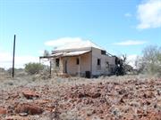
Cue Battery and Office comprises remnant battery infrastructure, including crushing facilities, steam engine, concrete footings and water tank. A former tailing dump was located to the south of the infrastructure, having been removed in 2022. The office, referenced in the LHS listing as a local landmark, was demolished between 2007 and 2014. Topography of the area is flat, and vegetation consists mainly of low scrub and grasses.
The original grant for the site was established in July 1919 as C Class Crown Land Reserve (ID 17275) and was identified as a ‘battery site’. The area of the reserve was increased in September 1919 to include Lots 194 and 196 (now known as 2 Railway Street) with the total area of the site listed as 30 acres (12.16 ha) in September 2020. The reserve was then vested to the Minister for Mines in September 1980 before being vested to Western Australian Mint for 21 years for ‘mineral processing’. In December 1992, the site was identified as Lot 590 (as seen today) and the site area was stated as being 11.68 ha. As of March 2015, the current vesting is listed as ‘Management order Western Australian Mint’ and the site area is stated as being 12.37 ha.
From a review of historical aerial photographs, battery buildings and tailings are shown to be present on the site from the earliest photograph with evidence of surface run off into the creek line to the southeast. By 1976, the buildings are absent (in line with information from the Shire of Cue that the battery infrastructure was destroyed by fire in 1968). By 1995, the tailings were shown to have been arranged into cells, which were subsequently removed from the site by 2022 (in line with information from the Shire of Cue that the residual tailings were removed by Westmill in 2018 and processed at an unspecified off-site facility). Areas of fly-tipped waste were present across offsite areas adjacent to the northeastern site boundary in the earliest historical photograph from 1962 and were observed to expand over the proceeding years.
A likely battery office and worker residences were present on the Marshall Street
reserve, 2 Railway Street and 1 Kinsella Street adjacent to the northeastern boundary
of the site. These buildings were demolished sometime between 2007 and 2014.
The MI notes condition as poor.
Individual Building or Group
| Epoch | General | Specific |
|---|---|---|
| Present Use | VACANT\UNUSED | Vacant\Unused |
| Original Use | MINING | Mining Battery |
| Original Use | MINING | Mine Office |
| Type | General | Specific |
|---|---|---|
| Roof | METAL | Corrugated Iron |
| Wall | METAL | Corrugated Iron |
| General | Specific |
|---|---|
| Economy | Mining and Mineral Resources |
| OCCUPATIONS | Mining {incl. mineral processing} |
This information is provided voluntarily as a public service. The information provided is made available in good faith and is derived from sources believed to be reliable and accurate. However, the information is provided solely on the basis that readers will be responsible for making their own assessment of the matters discussed herein and are advised to verify all relevant representations, statements and information.