

Local Government
Swan
Region
Metropolitan

10250 West Swan Rd Henley Brook
Municipal Inventory No: 503
Swan Valley Oasis Tourist Resort & Restaurant
Swan
Metropolitan
Constructed from 1900
| Type | Status | Date | Documents | More information |
|---|---|---|---|---|
| (no listings) |
| Type | Status | Date | Documents |
|---|---|---|---|
| (no listings) |
| Type | Status | Date | Grading/Management | More information | |
|---|---|---|---|---|---|
| Category | Description | ||||
| Municipal Inventory | Adopted | 25 Jun 1997 | Significant |
Significant |
|
| Municipal Inventory | Adopted | 30 Aug 2017 | Category 3 |
Category 3 |
|
| Local Heritage Survey | Adopted | 08 Apr 2026 | Category 3 |
Category 3 |
|
Henley Park Homestead (fmr) has cultural heritage significance for the following reasons:
• The place has some aesthetic value that, although substantially modified, has representative characteristics
of the Federation Bungalow style of architecture.
• The place has historical value reflecting the history of the settlement of the Swan Valley.
• The site has historical significance as part of the original Henley Park Estate.
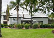
Henley Park Homestead (fmr) is a single storey brick building with a corrugated steel hipped roof displaying characteristics of the Federation Bungalow style of architecture.
The place now functions as the Swan Valley Hotel and Supa Golf facility. The original homestead has been adapted and incorporated into the current multi-use complex. The original dwelling functions as the reception for the hotel and is located along the western side of the complex towards the north-west corner.
The form of the original dwelling is still largely discernible, however, has been extended and adapted along the original southern elevation.
The place has an asymmetrical form with a “U” shaped hipped roof addressing the east. The hip and valley roof form suggests the original frontage may have addressed the south. The roof features four painted brick chimneys with decorative corbelling. The western elevation addresses West Swan Road and now features two projecting hipped bays connected by an enclosed bullnose verandah. The southern-most bay does not appear to be original and has likely been extended. The verandah is enclosed with glazing and serves as the main reception and entryway to the hotel.
The external walls are painted brick. The northern elevation features two original timber double hung windows with brick voussoirs.
A contemporary two storey hotel wing has been constructed to the north of the original dwelling. The hotel returns along the east and forms a central courtyard between the hotel and reception building.
To the south of the original dwelling, the complex has been extended to form a large recreational complex and restaurant. The east of the site features a large 9 hole “Supa Golf” course .
In late September 1829, Captain Stirling and Surveyor General Roe travelled to the head of the Swan River above Guildford with a group of European settlers to whom permission had been given to select land. These were the first rural grants in the Colony.
Land was granted to the settlers at a rate of 40 acres for every 3 pounds invested in the new colony. The original grants were along the navigable part of the Swan River between Upper Swan and Guildford. Henley Park, one of the grants, was so named by James Stirling for its resemblance to the estate of a kinsman in Surrey, England. It was an area of 3240 acres and was granted in 1830, to Military Commandant W. H. Mackie and Judge F. C. Irwin.
Most of the original grants, known as ‘ribbon grants’ from their elongated form, were between 6 and 18 miles long, running from the fertile alluvial land by the river. In 1829, carving incisions on trees at the riverbank marked the boundaries of the grants. No complete survey of the grants along the Swan and Helena Rivers was undertaken until the early 1840s. The grantees were required to fulfil location duties requiring the expenditure of 1s 6d on permanent improvements to the satisfaction of the Government before receiving freehold title to their grants.
From 1830 to 1837, Richard Edwards was employed as manager at Henley Park, where he built a two storey house for Irwin, utilising his skills as a brick-maker. On completion, it was reputed to be the finest in the Colony at that period. Further research is required to determine the location of this original two storey house.1
During the early days of European Settlement in the Swan Valley, the distance to travel to Perth and the barrier formed by the Swan River made it difficult for settlers living on the west side of the river to attend church. Since 1830, F. C. Irwin, a devout Anglican, had been holding services on his Henley Park property.
It was decided that a church would be built on the west side of the river at Upper Swan. The acre on which James Stirling had camped in 1827 was donated by Irwin and Mackie for the building of All Saints Anglican Church. The Church was constructed in 1839, by Richard Edwards, Irwin’s manager at Henley Park.2
The existing homestead is single storey and was likely constructed during the early 20th century. Aerial imagery indicates that the place remained relatively intact until the 1990s. In the early 1990s an extension was built to the south of the building. It appears that during this time the beginnings of a golf course were being constructed. By 2000 the site had been transformed into a ‘Supa Golf’ course and the residential property redeveloped for commercial use. The building was further extended to the east to accommodate a cafe and golf hire facilities, and to the north to accommodate hotel facilities. The homestead is still extant, however, has been extensively modified. In 2007 an additional mini-golf course was constructed to the east of the original homestead.3
Integrity - Moderate: The place has undergone numerous alterations and extensions.
Authenticity - Low: The place is no longer a private residence and is now a hotel and recreational venue.
Good.
| Ref Number | Description |
|---|---|
| 417 | Local Government Inventory 2019 |
Individual Building or Group
| Epoch | General | Specific |
|---|---|---|
| Present Use | FARMING\PASTORAL | Homestead |
| Original Use | FARMING\PASTORAL | Homestead |
| Type | General | Specific |
|---|---|---|
| Wall | BRICK | Common Brick |
| Roof | METAL | Corrugated Iron |
| General | Specific |
|---|---|
| DEMOGRAPHIC SETTLEMENT & MOBILITY | Settlements |
This information is provided voluntarily as a public service. The information provided is made available in good faith and is derived from sources believed to be reliable and accurate. However, the information is provided solely on the basis that readers will be responsible for making their own assessment of the matters discussed herein and are advised to verify all relevant representations, statements and information.