Local Government
Augusta/Margaret River
Region
South West
Leeuwin Rd Cape Leeuwin
Augusta/Margaret River
South West
Constructed from 1896 to 1970
| Type | Status | Date | Documents |
|---|---|---|---|
| Heritage List | Adopted | 08 Aug 2012 | |
| Commonwealth List | YES | 22 Jun 2004 | |
| State Register | Registered | 13 May 2005 | HCWebsite.Listing+ListingDocument, HCWebsite.Listing+ListingDocument |
| Type | Status | Date | Documents |
|---|---|---|---|
| (no listings) |
| Type | Status | Date | Grading/Management | |
|---|---|---|---|---|
| Category | ||||
| Municipal Inventory | Adopted | 01 Jul 2012 | Exceptional Significance | |
| Municipal Inventory | Adopted | 17 Jun 1996 | Criterion 1 | |
| Classified by the National Trust | Classified | 02 Jun 1970 | ||
| Survey of 20th Ctry Architecture | Completed | 01 Mar 1988 | ||
| Register of the National Estate | Permanent | 21 Oct 1980 | ||
| Name | Type | Year From | Year To |
|---|---|---|---|
| George Temple Poole | Architect | - | - |
| Library Id | Title | Medium | Year Of Publication |
|---|---|---|---|
| 7189 | Very much on watch : the Percy Willmott photos : Augusta, Margaret River, Busselton 1901 - 1919. | Book | 2003 |
| 5195 | Opportunity to develop visitor accommodation, facilities and services at the Cape Leeuwin Lighthouse and Cape Naturaliste Lighthouse precincts : guidelines for submissions. | Report | 2001 |
| 3519 | Leeuwin lighthouse : a brief history. | Book | 1996 |
| 482 | Historical sites in the Margaret River Augusta region : a photographic survey of documented and undocumented historical sites in the region carried out by students of the University of Western Australia, Department of Architecture. | Heritage Study {Other} | 1980 |
| 5468 | Review of improvements to meet building code of Australia for the Cape Leeuwin and Cape Naturaliste lighthouses. | Report | 2001 |
| 3423 | Conservation plan : Cape Leeuwin Lightstation Western Australia. | Heritage Study {Cons'n Plan} | 1992 |
| 7183 | Lighthouses of Australia : images from the end of an era. | Book | 2001 |
| 8667 | Leeuwin Lighthouse Precinct site plan. | Heritage Study {Other} | 2006 |
Individual Building or Group
| Epoch | General | Specific |
|---|---|---|
| Original Use | Transport\Communications | Water: Lighthouse |
| Present Use | Transport\Communications | Water: Lighthouse |
| Type | General | Specific |
|---|---|---|
| Roof | METAL | Corrugated Iron |
| Wall | ASBESTOS | Fibrous Cement, flat |
| Wall | STONE | Limestone |
| Wall | STONE | Granite |
| General | Specific |
|---|---|
| OUTSIDE INFLUENCES | Water, power, major t'port routes |
| TRANSPORT & COMMUNICATIONS | River & sea transport |
| OCCUPATIONS | Timber industry |
| OUTSIDE INFLUENCES | Tourism |
This information is provided voluntarily as a public service. The information provided is made available in good faith and is derived from sources believed to be reliable and accurate. However, the information is provided solely on the basis that readers will be responsible for making their own assessment of the matters discussed herein and are advised to verify all relevant representations, statements and information.
Constructed from 1895
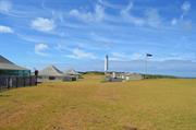
The following is an extract from the Heritage Council of WA’s Assessment Documentation for the place:Cape Leeuwin Lighthouse and Quarters, a small precinct which contains a stone lighthouse, keepers’ quarters (stone) and various service buildings, has cultural heritage significance for the following reasons:• the place is part of a system of coastal lights that was developed at the end of the nineteenth century by the various Australian colonies to improve the safety to shipping operating in Australian territorial waters. Although recognised as being of major importance to the eastern colonies, it was fully funded by the state government of Western Australia and the fourth coastal lighthouse constructed by the state government; • the place, in particular the lighthouse, has retained a high degree of authenticity and integrity; • the place has aesthetic value both in its design and as a striking landmark on Cape Leeuwin; • the place was historically important to the local timber industry which relied on small ships to transport the timber to other ports. As Cape Leeuwin could be treacherous in bad weather, the light was a valuable navigational aide; • the place represents a way of life that is no longer practised in Western Australia and one which is rapidly becoming scarce in other parts of Australia and the world; • the place has strong associations with John Forrest who tried for many years to establish a new light near Cape Leeuwin; with M.C. Davies, an important entrepreneur in Augusta, who pushed for a light on Cape Leeuwin and George Temple Poole who supervised the construction of the light and was responsible for the design of the keepers’ quarters; • the place is socially important to the people of Augusta-Margaret River for its tourist potential; • the place has the potential to reveal archaeological evidence about how people lived in isolated conditions; • the lighthouse is a fine example of the type of stone towers erected during the nineteenth century to house lights; and • the place at one time had the most powerful lamps in Australia and it was also the last to receive a modern tungsten lamp. While the new service buildings on the western side of the cottages are considered to have some historic importance, they are architecturally intrusive and are assessed as having low significance.
The following is an extract from the Heritage Council of WA’s Assessment Documentation for the place: Cape Leeuwin Lighthouse and Quarters comprises the stone lighthouse tower and oil store (1896), three stone cottages (1896) detached stone laundries to the cottages (1896), two asbestos cement garages (1953), asbestos cement store (former fuel room 1954), asbestos cement office (former power house, 1954), asbestos cement weather room (former radio hut 1954) and a new brick power house and beacon room (1970s). Detailed descriptions of each of the key elements of the site are included in the Heritage Council’s Assessment Documentation (available on-line at www.heritage.gov.au) The quarry used for the construction of the original buildings is still visible near the lighthouse site and is an integral feature for the purpose of this place record.
Agitation for a lighthouse in the south-west began around 1880, with one of the first sites suggested being St Alouarn Island. However the Forrest Government finally accepted the tender of Davies and Wishart (who had been pushing for the lighthouse) in 1895. The selection for the Cape Leeuwin site was influenced not only for its excellent location but also because of the availability of limestone in the area, making construction much easier and less costly. A good description of the lighthouse and cottages was given not long after its erection by George Hope in his study of the south-western districts in 1898: A sharp descent brings us to the level of the cape. The waters from the hills has formed a grassy swamp at their base, which we skirt, and, bowling along a well-made road, we drive out down the peninsular of rock and draw rein at one of the three comfortable stone cottages which have been built for the use of the lighthouse keepers on the east side of the cape. The lighthouse itself stands at the extreme point of Cape Leeuwin, in latitude 34 deg. 24 min. south, and longitude 115 deg. 09 min, east, the site chosen is about 70 feet above high water mark. The foundations are carried down 23 feet to the granite bed-rock, and the contract for erect was let to Messrs Davies and Wishart in April, 1895, the price being just under £8000, exclusive of the dome and light. The tower is cylindrical in form, and is 135 feet high from base to vane. The focal plane of the light is 185 feet above water level. The stone was all quarried within a half a mile of the building, and is handsome white politic ironstone rock. From the ground floor a door opens into the oil room where 10 large cylinders, five aside, with a capacity of 300 galloons each, hold the heavy mineral oil, of 240 deg. Test, which is specially adapted for lighthouse work…..Inside the walls, seven feet in thickness on the ground floor, an iron spiral staircase runs around the building to the summit, broken by seven floors at intervals. In the centre is a hollow iron column, which holds the chain and three-quarters of a ton weights propelling the clock-work that causes the lantern to revolve. On the fifth floor are the telephones connecting the lighthouse with the men’s quarters, and also with the post office at Karridale, whence all messages are forwarded onto the proper quarter by telegraph….Just overhead is a tank, which catches the rainfall from the dome, and from which it is drawn by a tap on this floor. Down the wall is a lightning conductor. The culminating point of interest is, of course, the lighting apparatus. This is on the sixth floor, and was furnished by Chance Bros and Co, Limited, of Birmingham, and was the first of its kind made…..There is a raised balcony on the top of the masonry at the sixth floor, outside the dome, from which a grand view is obtained up the coast north towards Hamelin Bay, and east past the mouth of the Blackwood……At the north-east corner of the structure is a large block of stone, inscribed on its northern aspect “Foundation stone laid by the Hon. Sir John Forrest, Premier of the Colony, 13th December, 1895,” and on its eastern side, “Dedicated to the world’s mariners, 10th December, 1896”. This is commemorative of the two ceremonies which marked the commencement of the undertaking. The lantern for the lighthouse cost £425 and the optical apparatus, £4.069. During the opening ceremony, newspapers of the colony and coins were placed in a jar and buried under the foundation stone and Mr Wishart presented the Premier with a silver trowel, suitably engraved, from the contracting firm, Davies and Wishart. The trowel is now in the Augusta Historical Museum.The two southerly cottages were built of the same stone as the lighthouse, but the third northern cottage was constructed of granite/gneiss, also from the site. There was also a timber cottage erected at the time, though this is no longer standing.An important associated feature, dating from the original development of the site, is the Cape Leeuwin Waterwheel (Place # CL-02).Cape Leeuwin Lighthouse was automated in 1982 and the keepers were withdrawn.As at 2012 the lighthouse continues to operate and has also been developed as a very popular tourist attraction.
High: The original use has been maintained. Varies across the site: High (The original/significant fabric is largely intact) to Medium (The place has had some alterations, but the original intent/character is still clearly evident).
Good *Assessed from streetscape survey only
| Name | Type | Year From | Year To |
|---|---|---|---|
| George Temple Poole | Architect | - | - |
| Ref ID No | Ref Name | Ref Source | Ref Date |
|---|---|---|---|
| George Hope;"Westralia: South Western Districts" p 48 | Geraldton express | 1898 | |
| HCWA Assessment Documentation | Cape Leeuwin Lightouse and Quarters | ||
| Cresswell,Gail J,The Light of Leeuwin:theAugusta/Margaret River Shire History | Augusta/Margaret River Shire History Group | 1989 | |
| Municipal Heritage Inventory | 1996 |
| Ref Number | Description |
|---|---|
| CL-01 | MI Place No. |
| A9915 | LGA Site No. |
| Reserve | Lot/Location | Plan/Diagram | Vol/Folio |
|---|---|---|---|
| 44660 | 5049 |
This information is provided voluntarily as a public service. The information provided is made available in good faith and is derived from sources believed to be reliable and accurate. However, the information is provided solely on the basis that readers will be responsible for making their own assessment of the matters discussed herein and are advised to verify all relevant representations, statements and information.
Leeuwin Rd Cape Leeuwin
Augusta/Margaret River
South West
| Type | Status | Date | Documents |
|---|---|---|---|
| (no listings) |
| Type | Status | Date | Documents |
|---|---|---|---|
| (no listings) |
| Type | Status | Date | Grading/Management | |
|---|---|---|---|---|
| Category | ||||
| Municipal Inventory | Adopted | 17 Jun 1996 | Criterion 5 | |
| Municipal Inventory | Adopted | 01 Jul 2012 | Historic Site 3 | |
00104 Cape Leeuwin Lighthouse and Quarters
Other Built Type
| Epoch | General | Specific |
|---|---|---|
| Original Use | MONUMENT\CEMETERY | Monument |
| Present Use | MONUMENT\CEMETERY | Monument |
| General | Specific |
|---|---|
| TRANSPORT & COMMUNICATIONS | River & sea transport |
This information is provided voluntarily as a public service. The information provided is made available in good faith and is derived from sources believed to be reliable and accurate. However, the information is provided solely on the basis that readers will be responsible for making their own assessment of the matters discussed herein and are advised to verify all relevant representations, statements and information.
Constructed from 1993, Constructed from 1945
HMAS Nizam Memorial is of significance: • As a war memorial erected by the "N" Class Destroyers Assn. of Australia to commemorate a tragic maritime event, the loss of life and the sacrifices made during World War Two.
This memorial has been constructed as roughly hewn, vertical stone plinth overlooking the ocean. The memorial plaques read:On the night of February 11, 1945 the destroyer HMAS NIZAM was struck by a freak wave at 22:15 hours, 11 miles due south of this point. Tragically, 10 ratings were swept overboard and lost at sea.The memorial was erected in their memory by the "N" Class Destroyers Assn. of Australia./ Lest We Forget./ Dedicated on 11th February 1993 by Captain W. F. Cook, L. V. O. R.A.N. (RTD) who was Commanding Officer of HMAS NIZAM.
In February 1945, HMAS Nizam was hit by a heavy squall as she rounded Cape Leeuwin in Western Australia. A huge sea from the starboard quarter caused the ship to keel over an estimated 60 to 70 degrees, burying the whole of her port side in the water. The ship was travelling at 21 knots and the water swept down the ship sweeping boats, davits and sailors overboard. Ten were lost at sea and no trace of them has ever been found. On 11 February 1993, a plaque was erected near the tip of Cape Leeuwin by the "N" Class Destroyers Association of Australia to commemorate this tragic war time event.
High: The original use has been maintained. High: The original/significant fabric is largely intact.
Good
| Ref ID No | Ref Name | Ref Source | Ref Date |
|---|---|---|---|
| Cresswell, Gail J,The Light of Leeuwin:the Augusta/Margaret River Shire History | Augusta/Margaret River Shire History Group | 1989 | |
| Augusta Historical Society Heritage Booklet | 2010 | ||
| Municipal Heritage Inventory | 1996 |
| Ref Number | Description |
|---|---|
| CL-03 | MI Place No. |
| A9915 | LGA Site No. |
| Reserve | Lot/Location | Plan/Diagram | Vol/Folio |
|---|---|---|---|
| 44660 | 5049 |
This information is provided voluntarily as a public service. The information provided is made available in good faith and is derived from sources believed to be reliable and accurate. However, the information is provided solely on the basis that readers will be responsible for making their own assessment of the matters discussed herein and are advised to verify all relevant representations, statements and information.

Leeuwin Rd, Quarry Bay Cape Leeuwin
Via Augusta
Augusta/Margaret River
South West
Constructed from 1895
| Type | Status | Date | Documents |
|---|---|---|---|
| Heritage List | Adopted | 08 Aug 2012 | |
| State Register | Registered | 14 May 2002 | HCWebsite.Listing+ListingDocument, HCWebsite.Listing+ListingDocument |
| Type | Status | Date | Documents |
|---|---|---|---|
| (no listings) |
| Type | Status | Date | Grading/Management | |
|---|---|---|---|---|
| Category | ||||
| Register of the National Estate | Interim | 21 Mar 1978 | ||
| Classified by the National Trust | Classified | 11 Dec 2000 | ||
| Register of the National Estate | Registered | 21 Mar 1978 | ||
| Municipal Inventory | Adopted | 17 Jun 1996 | Criterion 2 | |
| Municipal Inventory | Adopted | 07 Jul 2012 | Exceptional Significance | |
Undergoing process of calcification
| Library Id | Title | Medium | Year Of Publication |
|---|---|---|---|
| 482 | Historical sites in the Margaret River Augusta region : a photographic survey of documented and undocumented historical sites in the region carried out by students of the University of Western Australia, Department of Architecture. | Heritage Study {Other} | 1980 |
Historic site
| Epoch | General | Specific |
|---|---|---|
| Original Use | Transport\Communications | Water: Other |
| Present Use | SOCIAL\RECREATIONAL | Other |
| Type | General | Specific |
|---|---|---|
| Other | STONE | Limestone |
| Other | TIMBER | Other Timber |
| General | Specific |
|---|---|
| TRANSPORT & COMMUNICATIONS | River & sea transport |
| OCCUPATIONS | Timber industry |
| DEMOGRAPHIC SETTLEMENT & MOBILITY | Technology & technological change |
This information is provided voluntarily as a public service. The information provided is made available in good faith and is derived from sources believed to be reliable and accurate. However, the information is provided solely on the basis that readers will be responsible for making their own assessment of the matters discussed herein and are advised to verify all relevant representations, statements and information.
Constructed from 1895
The following is an extract from the Heritage Council of WA’s Assessment Documentation for the place: Cape Leeuwin Waterwheel, comprising a timber waterwheel, supported on a limestone base together with a timber flume that carries water from a nearby spring, is considered to have cultural heritage significance for the following reasons: • the use of a waterwheel to drive a pump to deliver fresh water is unique in Western Australia; • the place was an essential part of the Cape Leeuwin Lighthouse precinct which became an important component in a national system of coastal lights and therefore, by association, contributed to the safety of mariners and coastal shipping; • the industrial aesthetic of the gradually calcifying waterwheel, together with the adjacent lighthouse, provide a visual contrast to the surrounding natural environment; • the place has strong social significance for the local community who have continued to maintain the structure over the years; • the place displays an innovative use of waterwheel technology and is an excellent representative example of waterwheel technology; and, • the place has strong associations with M.C. Davies who built the lighthouse and quarters and may have designed the waterwheel.
The following is an extract from the Heritage Council of WA’s Assessment Documentation for the place:The water wheel sits just above the high tide line in a small cove approximately one kilometre to the north of the Cape Leeuwin Lighthouse Quarters. This area lies within the Leeuwin–Naturaliste National Park. The lighthouse can just be seen when looking south from the water wheel. The timber flume, which carried the water to the wheel, extends out eastward from the wheel and disappears in the low brush which is found throughout this area.The flume consists of three timber planks that have been screwed together to form a base and two sides. Cross-ties have been screwed to the top of the flume at regular intervals. The wheel assembly is located just above the high water mark. The flume rests on the ground, except close to the wheel where it is supported on limestone piers, as the land falls down towards sea level.At the base of the water wheel, on the southern side, there is evidence of the remains of the hydraulic ram. The air chamber is still in situ. Beyond the waterwheel, to the south, a small portion of concrete remains on the shoreline, displaying a long impression which was probably made by a pipe. This evidence indicates the line that the water pipe took from the waterwheel to the lighthouse keeper’s quarters.The waterwheel’s shaft rests between two limestone walls. Both the wheel and the walls have become heavily encrusted with lime which has been deposited over the years by the water which flows over the wheel. This accumulation has led to the wheel gradually becoming inoperable. Seepage along the wooden flume has also encrusted the limestone piers.The limestone coating affords the timber wheel some protection. It is considered to be in a stable condition at present. The flume appears to be a recent reconstruction, possibly dating from 1998 when CALM carried out work to allow water to flow over the wheel again. The timber flume extends some 60 metres into the scrub at which point it is replaced by a fibreglass trough. It is not known how far this trough extends into the scrub.
The following is an extract from the Heritage Council of WA’s Assessment Documentation for the place:Maurice Davies grew up in the Victorian goldfields and became a building supplier and contractor. He moved to Adelaide where he went into partnership with John Wishart. In 1875, Davies moved to Western Australia and as M C Davies & Co established a large timber milling business in the south west.Following the European settlement of Australia in 1788, lighthouses had gradually been erected at strategic locations around the coast. The majority of these lights were erected in the eastern colonies, generally at the expense of the colony in which the light was located. In 1873, at an inter-colonial conference, it was agreed that there was a need for two new lighthouses at Cape Naturaliste and Cape Hamelin that would benefit shipping heading towards the eastern colonies, and that the cost of erecting them should be borne by all the colonies and not just Western Australia.M C Davies also saw a need for a light near the south-west cape as his timber mills exported large quantities of timber from ports in this area. He began urging the construction of a light in 1881.However, when Sir John Forrest sought monetary support from the eastern colonies, he found themunwilling to assist. It was not until 1893 that the Western Australian Government was able to afford the cost of erecting a light with Cape Leeuwin being chosen as the most suitable site.Cape Leeuwin was a remote location in the 1890s and the only reliable water source was a fresh water spring located some miles to the north of the lighthouse site. One component of the contract stipulated the construction of a waterwheel which would provide water to the site. Maurice Davies and his partner John Wishart won the tender to erect a lighthouse, quarters and a waterwheel to supply water to the site, for the sum of £7,782.11s.6p. The contract period was to run from 2 April 1895 to 1 February 1896. The cost of erecting the wheel was to be borne by the contractors.The waterwheel was completed by the time the lighthouse was officially dedicated on 10 December 1896 and after the opening of the lighthouse, the official party visited the waterwheel for an inspection of the apparatus. Water was drawn from a freshwater spring lying to the east, located slightly above sea level and carried via a wooden flume to the waterwheel. The wheel supplied power to a hydraulic ram which then pumped water up to the lighthouse keepers quarters.In the 1920s an oil engine was included in this operation. The wheel was bypassed by pipe leading to the hydraulic ram directly. In 1978 the lighthouse and cottages were connected to the Augusta town water supply. Cape Leeuwin Lighthouse was automated in 1982 and the keepers were withdrawn. Cape Leeuwin Waterwheel has become a popular tourist spot that is visited regularly by national and international tourists and also members of the local community. The Department of Conservation and Land management (CALM) began rudimentary maintenance operations in the late eighties in a bid to halt the deterioration of the waterwheel due to the decline in the amount of water available from Leeuwin Spring. The use of the spring water for the town water supply and the increasing draw down on the water resource led to the drying out of the timber flume and the waterwheel. This caused some of the lime deposit to flake off, exposing the timber to weathering. The local business association and CALM staff replaced the timber sections of the flume and extended its length in an attempt to obtain additional water flow over the wheel. Following this, CALM installed a pipeline from a toilet block to the east of the site and erected a trickle irrigation sprinkler system, which was designed to prevent the flume timbers from splitting. This proved ineffective due to the insufficient volume of water available through the water supply system from the toilet block. In 1999, the Water Corporation and CALM staff erected a separate pipeline directly from Leeuwin Spring to the flume in a bid to ensure the flume and waterwheel were kept moist at all times.In 2002 the place was entered on the HCWA Register of Heritage Places.
Medium: The use has been altered, but the original use is still clearly evident through interpretation of the fabric. Medium: The place has had some alterations, but the original intent/character is still clearly evident.
Fair *Assessed from streetscape survey only
| Ref ID No | Ref Name | Ref Source | Ref Date |
|---|---|---|---|
| Cape Leeuwin Waterwheel | HCWA Assessment Documentation | ||
| Cresswell, Gail J, The Light of Leeuwin: the Augusta/Margaret River Shire History | Augusta/Margaret River Shire History Group | 1989 | |
| Municipal Heritage Inventory | 1996 |
| Ref Number | Description |
|---|---|
| A11023 | LGA Site No. |
| CL-02 | MI Place No. |
| Reserve | Lot/Location | Plan/Diagram | Vol/Folio |
|---|---|---|---|
| 8428 | 304 |
This information is provided voluntarily as a public service. The information provided is made available in good faith and is derived from sources believed to be reliable and accurate. However, the information is provided solely on the basis that readers will be responsible for making their own assessment of the matters discussed herein and are advised to verify all relevant representations, statements and information.
Lot 303 Ellen Brook Rd Gracetown
7km NW of Margaret River on an unnamed road, off Caves Rd. On the right bank of Ellen Brook, near its mouth.
Ellensbrook Farm Home for Aboriginal Children
Ellensbrook Farmhouse, Dam & Waterfall
Augusta/Margaret River
South West
Constructed from 1857 to 1903
| Type | Status | Date | Documents |
|---|---|---|---|
| Heritage List | Adopted | 08 Aug 2012 | |
| State Register | Registered | 17 Aug 2012 | HCWebsite.Listing+ListingDocument, HCWebsite.Listing+ListingDocument |
| Type | Status | Date | Documents |
|---|---|---|---|
| (no listings) |
| Type | Status | Date | Grading/Management | |
|---|---|---|---|---|
| Category | ||||
| Municipal Inventory | Adopted | 17 Jun 1996 | Criterion 1 | |
| Municipal Inventory | Completed\Draft | 01 Jul 2012 | Exceptional Significance | |
| Classified by the National Trust | Classified {Lscpe} | |||
| Aboriginal Heritage Sites Register | Permanent | |||
| Classified by the National Trust | Classified | 01 May 1978 | ||
| Register of the National Estate | Permanent | 21 Oct 1980 | ||
| Aboriginal Heritage Sites Register | Interim | |||
The place is in good condition following substantial restoration works in the 1980s and ongoing maintenance by the National Trust and Department of Conservation and Land Management/ Department of Environment and Conservation.
| Name | Type | Year From | Year To |
|---|---|---|---|
| Alfred & Ellen Bussell | Architect | - | - |
| Bussell, A.P. | Architect | - | - |
| Library Id | Title | Medium | Year Of Publication |
|---|---|---|---|
| 12248 | Final report : Conservation of Ellensbrook Homestead Margaret River | Conservation works report | 1990 |
| 4636 | A Nyungar interpretation of Ellensbrook and Wonnerup homesteads. | Heritage Study {Other} | 1994 |
| 471 | Ellensbrook | Heritage Study {Other} | 198 |
| 541 | Preliminary report on the proposed restoration of Ellensbrook. | Heritage Study {Other} | 1989 |
| 7040 | Ellensbrook : conservation plan. | Heritage Study {Cons'n Plan} | 2004 |
| 2012 | Conservation study Ellensbrook Margaret River Western Australia. | Heritage Study {Other} | 1992 |
| 482 | Historical sites in the Margaret River Augusta region : a photographic survey of documented and undocumented historical sites in the region carried out by students of the University of Western Australia, Department of Architecture. | Heritage Study {Other} | 1980 |
Individual Building or Group
| Epoch | General | Specific |
|---|---|---|
| Original Use | FARMING\PASTORAL | Homestead |
| Present Use | FARMING\PASTORAL | Homestead |
| Style |
|---|
| Vernacular |
| Type | General | Specific |
|---|---|---|
| Roof | METAL | Corrugated Iron |
| Wall | EARTH | Wattle and Daub |
| Wall | PLASTER | Lathe and Plaster |
| Wall | TIMBER | Weatherboard |
| General | Specific |
|---|---|
| DEMOGRAPHIC SETTLEMENT & MOBILITY | Land allocation & subdivision |
| OCCUPATIONS | Grazing, pastoralism & dairying |
| DEMOGRAPHIC SETTLEMENT & MOBILITY | Workers {incl. Aboriginal, convict} |
| DEMOGRAPHIC SETTLEMENT & MOBILITY | Aboriginal Occupation |
| SOCIAL & CIVIC ACTIVITIES | Institutions |
| OUTSIDE INFLUENCES | Tourism |
| OCCUPATIONS | Hospitality industry & tourism |
| OCCUPATIONS | Domestic activities |
| DEMOGRAPHIC SETTLEMENT & MOBILITY | Racial contact & interaction |
| PEOPLE | Local heroes & battlers |
| PEOPLE | Early settlers |
This information is provided voluntarily as a public service. The information provided is made available in good faith and is derived from sources believed to be reliable and accurate. However, the information is provided solely on the basis that readers will be responsible for making their own assessment of the matters discussed herein and are advised to verify all relevant representations, statements and information.
Constructed from 1855
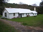
The 2002 Conservation Plan for Ellensbrook found that it is of exceptional significance because: • The place is an excellent and rare representative example of original settlement in the Margaret River district and with the pioneering development of dairy farming and sheep and cattle grazing in the Augusta-Margaret River area in the colonial period; • The place has association with the Bussell family, and other pioneer settlers at Augusta and Busselton; • The place reflects pioneer building techniques and the use of local materials; • The place has association with the pioneering development of tourism in the Augusta-Yallingup area; • The place demonstrates changing land-uses from pre-settlement to the present time as well as the application of changing government policy and land regulations in the 19th and 20th centuries; • The place demonstrates the functions and processes of natural physical systems and for specific features which include: the coastal dunes; caves and waterfall; geologic formations of the Leeuwin-Naturaliste Ridge; Ellen Brook indigenous flora and fauna; • The place is significant as a cultural landscape which demonstrates the successive impacts of Aboriginal and white settlement on the natural environment; • The place has Aboriginal associations which include the archaeological site; Meekadarribee legend; waterfall and cave; Aboriginal people linked with building and working on Ellensbrook and Ellensbrook Farm Home for Aboriginal children.
The following description is an extract from the Heritage Council’s assessment documentation for the place: Comprises: a single storey vernacular style homestead constructed of local materials including field granite, locally quarried limestone, paperbark, hand-split timber slabs, driftwood and a timber roof beam from the rig of a small ship, located in a grassed clearing alongside Ellen Brook in a natural bush setting behind the coastal dune system, and including a family grave site (1850s-1860s), stone dam wall, flume and waterwheel (1950s), remnant Tea Tree hedge (Leptospermum laevigatum) (date unknown) [destroyed by bushfire in November 2011], Mulberry tree (Morus sp.) (date unknown) and 1950s plantings of Moreton Bay Fig (Ficus macrophylla), Norfolk Island Pine (Araucaria excelsa), Flame Tree (Erythrina sp), Pepper Tree (Schinus terebinthifolia) and Hydrangeas (Hydrangea sp.) At the time of inspection (February 2012) the immediate bush setting was in the very early stages of recovery from a major bushfire.
Ellensbrook is a small cluster of wattle and daub buildings built for Alfred and Ellen Bussell. Construction began in 1855 when the Bussells had left their home in the Vasse to settle near the Margaret River on a 10 acre land grant given to Alfred. They chose a site, close to the sea, which had a brook (Ellen Brook) running through the property. This is where the new house was located. Driftwood was used as a ridge beam and rough bush poles and paperbark were used to create a framework for the house which was later sealed with a special type of plaster. With the help of the local Aboriginals they created a plaster by burning limestone from nearby dunes.Ellen established a dairy and a garden at their home, and there were also crops of potatoes and other vegetables, oats, barley and wheat. As the years passed, Ellensbrook grew as the family grew. The additions to the house took on an L-shape, following the contours of the land.In the early years at Ellensbrook, until they were able to grow their own crops successfully, life was not easy for the Bussells. They were isolated and supplies were short and expensive. Ellen was often left alone with the children, especially as Alfred kept adding to his property and had to erect many miles of post and rail fence, as well as bridges. By 1858, the Bussells had outgrown Ellensbrook and had to look for other land upon which to build a new home. This new home was known as Wallcliffe (Pace # PR-02).In addition to the house, the Ellensbrook property also holds a gravesite in Ellen’s peppermint grove where three of the Bussell’s sons were buried – Jasper, Christopher and Hugh. William Cheesewell, who was a servant of the Bussells is also buried there. There are remains of a post and rail fence which was part of the Ellensbrook original fencing south of the Cowaramup Bay turnoff. The Noongar know the place as Mokidup, a place which had been a traditional summer camping spot for thousands of years. Just 500 metres away from the homestead is the Mika Darabi (Meekadarribee) which means ‘place where the moon rests.’ The Dreaming story goes that ‘the waterfall flowed down the hillside, past the cave, where the moon came ‘when she vanished from the sky to bathe and recover her gleaming silver in the hidden store within the cavern.’ The cave is home to Aboriginal spirits of Mitanne and Nobel, lovers who are reunited and the waterfall ‘echoes their laughter.’ After Alfred and his family moved from Ellensbrook to Wallcliffe the property was taken over by his sisters Fanny and Edith. In 1898 Edith established an Aboriginal Mission on the property, the ‘Ellensbrook Farm Home for Aboriginal Children.’’ Noongar people were allowed to stay and work on the property in return for food and shelter. The mission operated until 1917. To the Noongar Ellensbrook stands as a ghost house, representing the pain suffered by their people.Ellensbrook continued to be owned and mostly occupied by direct descendents of the Bussell family until 1956, including Frances (Fanny) Brockman, Edith Bussell, and Lennox and Frances Terry.In 1979 the homestead was donated to the National Trust and since then major restoration works have taken place. In 1992 Ellensbrook Farmhouse, Dam and Waterfall (0115) were added onto the Heritage Council of Western Australia’s Register of Heritage Place (Interim Status). As at 2012 the place is a National Trust managed property, open to the public.
Medium: The use has been altered, but the original use is still clearly evident through interpretation of the fabric. High: The original/significant fabric is largely intact.
Good *Assessed from streetscape survey only
| Ref ID No | Ref Name | Ref Source | Ref Date |
|---|---|---|---|
| Cresswell, Gail J,The Light of Leeuwin:the Augusta/Margaret River Shire History | Augusta/Margaret River Shire History Group | 1989 | |
| Frances Terry, They came to the Margaret | Bunbury | 1978 | |
| Emails correspondence | National Trust of Australia (WA) tothe Shire of Augusta-Margaret River | 18/6/2012 | |
| Department of Education website | http://www.det.wa.edu.au/aboriginaleducation | ||
| Australian Institute of Aboriginal and Torres Strait Islander Studies | http://www.aiatsis.gov.au/ | ||
| Ellensbrook | Conservation Plan, | 2002 | |
| Collard, Len, A Nyungar Interpretation of Ellensbrook & Wonnerup Homesteads, | National Trust of Australia (WA) | 1994 |
| Ref Number | Description |
|---|---|
| GR-01 | MI Place No. |
| A4420 | LGA Site No. |
| Reserve | Lot/Location | Plan/Diagram | Vol/Folio |
|---|---|---|---|
| 22673 |
This information is provided voluntarily as a public service. The information provided is made available in good faith and is derived from sources believed to be reliable and accurate. However, the information is provided solely on the basis that readers will be responsible for making their own assessment of the matters discussed herein and are advised to verify all relevant representations, statements and information.

134 Old Ellen Brook Rd Gracetown
Augusta/Margaret River
South West
Constructed from 1888 to 1950
| Type | Status | Date | Documents |
|---|---|---|---|
| Heritage List | Adopted | 08 Aug 2012 | |
| State Register | Registered | 27 Nov 1998 | HCWebsite.Listing+ListingDocument, HCWebsite.Listing+ListingDocument |
| Type | Status | Date | Documents |
|---|---|---|---|
| (no listings) |
| Type | Status | Date | Grading/Management | |
|---|---|---|---|---|
| Category | ||||
| Municipal Inventory | Adopted | 17 Jun 1996 | Criterion 1 | |
| Municipal Inventory | Adopted | 01 Jul 2012 | Exceptional Significance | |
| Classified by the National Trust | Recorded | 01 Sep 1978 | ||
| Register of the National Estate | Indicative Place | |||
Partly demolished, 1995
| Name | Type | Year From | Year To |
|---|---|---|---|
| Keenan, Stewart | Architect | - | - |
| Library Id | Title | Medium | Year Of Publication |
|---|---|---|---|
| 5400 | Glenbourne homestead, Margaret River : conservation works | Conservation works report | 2002 |
| 482 | Historical sites in the Margaret River Augusta region : a photographic survey of documented and undocumented historical sites in the region carried out by students of the University of Western Australia, Department of Architecture. | Heritage Study {Other} | 1980 |
| 4458 | Glenbourne Homestead : conservation plan. | Heritage Study {Cons'n Plan} | 2000 |
| 226 | Glenbourne House Margaret River : heritage assessment. | Heritage Study {Other} | 1993 |
Individual Building or Group
| Epoch | General | Specific |
|---|---|---|
| Original Use | COMMERCIAL | Hotel, Tavern or Inn |
| Present Use | FARMING\PASTORAL | Homestead |
| Style |
|---|
| Vernacular |
| Type | General | Specific |
|---|---|---|
| Roof | METAL | Corrugated Iron |
| Wall | EARTH | Wattle and Daub |
| Wall | STONE | Granite |
| Wall | TIMBER | Weatherboard |
| Wall | TIMBER | Slab |
| Other | STONE | Granite |
| General | Specific |
|---|---|
| OCCUPATIONS | Hospitality industry & tourism |
| DEMOGRAPHIC SETTLEMENT & MOBILITY | Settlements |
| OCCUPATIONS | Grazing, pastoralism & dairying |
This information is provided voluntarily as a public service. The information provided is made available in good faith and is derived from sources believed to be reliable and accurate. However, the information is provided solely on the basis that readers will be responsible for making their own assessment of the matters discussed herein and are advised to verify all relevant representations, statements and information.
Constructed from 1888, Constructed from 2002
The following is an extract from the Heritage Council of WA’s Assessment Documentation for the place: Glenbourne Homestead, a timber slab, stone and weatherboard farm house (partly demolished) and associated stone oven, has cultural heritage significance for the following reasons: • the place has potential to yield information about, and promote the understanding of, a range of nineteenth century construction techniques used by early settlers in the South West region; • the place contributes to an understanding of the pattern of European settlement in the South West of the State and is associated with the development of the dairying, agricultural, timber and hospitality industries in that region; and, • the place is highly valued by the local community for its associations with the Keenan family and the development of Margaret River and the South West region.
The following is an extract from the Heritage Council of WA’s Assessment Documentation for the place (dated 1998):Glenbourne Homestead is situated on a grassy rise in established farmland to the north of the Ellens Brook water course.The homestead is in a semi-demolished state, with only three of the rooms with any semblance of intactness. The homestead is located in a fenced area peppered with peach, apple and almond trees and a large mulberry tree. The remains of a concrete path approaches the verandah from the east. Two corrugated iron cement lined water tanks stand on the south-west corner of the house in very poor condition.A rough stone oven [ruin] is located to the south west of the house just outside the existing fence line. This oven consists of uncut local stone piled up and mortared together, with iron bar lintels supporting the fire box roof. Several materials have been used to clad the exterior walls of the house: timber slab, weatherboard, stone and asbestos cement. Slab wall construction was used on the eastern, northern and western elevations, stone work on a small area of the south western corner, and weatherboard on the southern elevation and an enclosed portion of the verandah. Asbestos cement cladding is confined to wet area additions constructed in the 1950s. Wall construction is chiefly vertically placed split timber slab. This also determines the oldest part of the structure. The slabs are earth fast and fixed at the top with a dressed timber rail or plate. Dressed corner posts and intermediate studwork (for openings) have also been used. The external face of the slabs has been left undressed and the internal face lined with lath and plaster. Ti-Tree timber laths are rough split in the traditional way, and fixed to the slabs with flat head nails. Plaster appears to have been made from lime and sand and then coated with lime wash. Internal slab walls are lined with lath and plaster on both sides.Since that time extensive conservation works have been undertaken and the place has been restored to a weather tight condition, including the repair of walls, the replacement of fibrous cement sheeting with square-edged weatherboards, the installation of new casement windows, and a new corrugated profile roof. The immediate area includes the old fruit trees and new vegetable gardens and retains an informal setting. The place is overlooked by (but well-separated from) a large new residential building further up the hillside.There is no evidence that the place is actively used.
In 1870 Stewart Keenan took up a cattle run at the Margaret, securing 4000 acres around the area of Margaret River. The original lease was for a Mr Forrest and Mr Abbey as well as Keenan, but eventually Keenan took over the whole lease.In 1887 Keenan took up a 200 acre block on the north bank of Ellensbrook,facing Spring Road [now Caves Rd] and in 1888, together with his son-in-law, James Armstrong, began splitting timber for the building of a home.The original structure consisted of a large dining/living area at the south end, another good sized room and an adjoining sitting room. A gable roof covered this part of the building. At the rear of these rooms, under a skillion roof, were two small bedrooms and a kitchen with a stone floor. A door opened from the kitchen to a cobble stoned area at the back of the house and washing facilities were arranged on a rough wooden slab running along the outside of the kitchen wall.The family moved into their new home in the winter of 1889, and commenced dairy farming operations and a large, associated, cattle run consisting of 2000 acres in Rosa Brook area, and 2000 acres north of Margaret River, up to Bramley. About the turn of the century, Grace and Jack Catherall (niece and nephew to Keenan) lived at Glenbourne and added two more rooms higher up the hill at the north end of the front veranda. Although the Catheralls stayed only a short time this part of Glenbourne became known as ‘Jack’s House’ (demolished in the 1960s). The Keenan’s two daughters later cut a track between Glenbourne and the railway (north of the Margaret River) so that produce could be transported by horse and cart instead of by horseback. This track is now called Carters Road.During this early period, Glenbourne also had an association with the local Noongar community. It was visited by Aboriginals, and Queen Jinny stayed there on a number of occasions. It is believed that Queen Jinny and Isabella Keenan formed a strong relationship, particularly after King Bungitch died. Of Stewart and Isabella Keenan’s nine children, Robert John and Mary Ellen (a.k.a. Minnie) were the only ones to remain at Glenbourne. They inherited the property after Isabella's death and Minnie stayed on at the property until 1958, when it was sold due to her failing health. Glenbourne was purchased by John Williams, who owned it for two years before selling it to Robert and Thelma Brooke. The Brookes owned the property for fourteen years, during which time caretaker Albert Atkins occupied Glenbourne Homestead.The Margaret River Conservation Farming Club then purchased the property, in March 1977. One of the conditions of sale was that Albert be allowed to live in Glenbourne Homestead for as long as he wished. The Margaret River Conservation Farming Club, one of several established in the South-west during the 1970s, acquired Glenbourne with the object of combining simple farming with recreation and nature conservation. The Club built a large Clubhouse, which extends along a ridge above Glenbourne Homestead, and did not used the old farmhouse, aside from the occasional storage of timber.By the early 1990s, Glenbourne Homestead had become derelict and some members of the Club, who feared it could be dangerous to children, decided to commence demolition. Other members opposed this action, but by the time the demolition was halted considerable damage had been done to the fabric. When inspected in September 1997, the house remained fenced-off, unused, and in a semi-collapsed condition. Glenbourne was entered in the Sate Register of Heritage Places in 1998. A conservation plan was written in 2000 and major conservation works were undertaken in 2002.
Medium: The use has been altered, but the original use is still clearly evident through interpretation of the fabric. Medium: The place has had some alterations, but the original intent/character is still clearly evident.
Good to Fair *Assessed from streetscape survey only
| Ref ID No | Ref Name | Ref Source | Ref Date |
|---|---|---|---|
| Glenbourne Homestead | conservation works | 2002 | |
| Glenbourne Homestead (00116) | HCWA Assessment Documentation | ||
| Municipal Heritage Inventory | 1996 | ||
| Tamblyn M, 'Johns, Joseph Bolitho (1827–1900),' Australian Dictionary of Biography, National Centre of Biography, Australian National University | http://adb.anu.edu.au/biography/johns-joseph-bolitho-3859/text6139 | ||
| Cresswell, Gail J, The Light of Leeuwin: the Augusta/Margaret River Shire History | Augusta/Margaret River Shire History Group, | 1989 | |
| Hocking Planning and Architecture | Glenbourne Homestead: Conservation Plan | 1999-2000 |
| Ref Number | Description |
|---|---|
| A2799 | LGA Site No. |
| GR-02 | MI Place No. |
| Reserve | Lot/Location | Plan/Diagram | Vol/Folio |
|---|---|---|---|
| 354 |
This information is provided voluntarily as a public service. The information provided is made available in good faith and is derived from sources believed to be reliable and accurate. However, the information is provided solely on the basis that readers will be responsible for making their own assessment of the matters discussed herein and are advised to verify all relevant representations, statements and information.

Caves Rd Karridale
Old Karridale Caves Road
Karridale Townsite Chimney
Old Karridale Townsite Chimney
Augusta/Margaret River
South West
Constructed from 1883
| Type | Status | Date | Documents |
|---|---|---|---|
| Heritage List | Adopted | 08 Aug 2012 | |
| State Register | Registered | 21 Sep 2001 | HCWebsite.Listing+ListingDocument, HCWebsite.Listing+ListingDocument |
| Type | Status | Date | Documents |
|---|---|---|---|
| (no listings) |
| Type | Status | Date | Grading/Management | |
|---|---|---|---|---|
| Category | ||||
| Classified by the National Trust | Classified | 01 May 1978 | ||
| Municipal Inventory | Adopted | 17 Jun 1996 | Criterion 1 | |
| Municipal Inventory | Adopted | 01 Jul 2012 | Exceptional Significance | |
| Library Id | Title | Medium | Year Of Publication |
|---|---|---|---|
| 9958 | Tempered by fire. Stories from the firefighters and survivors of the 1961 Western Australian bushfires. | Book | 2012 |
Historic site
| Epoch | General | Specific |
|---|---|---|
| Present Use | VACANT\UNUSED | Vacant\Unused |
| Original Use | FORESTRY | Timber Mill |
| Style |
|---|
| Victorian Egyptian |
| Type | General | Specific |
|---|---|---|
| Wall | BRICK | Common Brick |
| Wall | EARTH | Other Earth |
| Wall | STONE | Granite |
| General | Specific |
|---|---|
| DEMOGRAPHIC SETTLEMENT & MOBILITY | Resource exploitation & depletion |
| OCCUPATIONS | Timber industry |
| DEMOGRAPHIC SETTLEMENT & MOBILITY | Technology & technological change |
This information is provided voluntarily as a public service. The information provided is made available in good faith and is derived from sources believed to be reliable and accurate. However, the information is provided solely on the basis that readers will be responsible for making their own assessment of the matters discussed herein and are advised to verify all relevant representations, statements and information.
Constructed from 1982, Constructed from 1882
The following is an extract from the Heritage Council of WA’s Assessment Documentation for the place: Davies Park and Foundry Chimney, a culturally modified landscape containing a substantial and massively proportioned part of a furnace flue, oven ruin, donkey engine boiler, and other archaeological material relating to Karridale Mill, has cultural heritage significance for the following reasons: • the foundry flue was constructed in c. 1883, by M C Davies shortly after he founded the mill at Karridale, and it was an integral part of the timber company’s operation from its completion until the early twentieth century and is the only substantial evidence of the mill; • the remaining evidence of the industrial processes associated with timber milling in the late nineteenth and early twentieth century are amongst. the few remaining of their type and therefore have rarity value; • it is closely associated with M C Davies and his family, whose company developed the place, and after whom the site is now named Davies Park. The place is also associated with Millars' Karri and Jarrah Company, which owned and operated the mill following the amalgamation of 1902; and, • the stone construction remaining section of flue is a finely constructed piece of Victorian industrial architecture. The park entrance portal, stone construction barbecue and fences to parts of the site perimeter, together with re-growth plant material have little significance.
Davies Park and Foundry Chimney is located in a reserve to the east of Caves Road. It comprises the remains of a furnace chimney, remains of an oven, and a donkey engine, in a setting of re-growth forest. The area is likely to contain other archaeological material relating to the milling operation and related uses.The cultural features are all located at the far eastern side of the site, alongside the old rail permanent way, and set within a zone between 9 and 21 metres from the boundary fence. The foundry furnace (constructed of random rubble granite) is located in the north-eastern corner, the oven (also random rubble granite) in the south-eastern corner, and the cast iron donkey engine a few metres west of the oven.Other features relating to the development of the site as a park include a stone barbecue, and an entry portal to the Caves Road frontage, constructed in bushpoles, with a cattle grid under it.The site is quite overgrown, with re-growth Jarrah, Peppermint trees, Acacia and bracken ferns. The vegetation obscures clear views of all the cultural material, and the main feature, the foundry chimney, can no longer be seen from the road.For a more detailed description of the place, see the HCWA Assessment Documentation Davies Park and Foundry Chimney (00124) at http://register.heritage.wa.gov.au/.
In 1875, Maurice Coleman Davies, a contractor in Adelaide, visited Western Australia to inspect the timber industry. Davies was to become the driving force behind the timber industry in the South West, promoting Western Australian timber in Australia and internationally.Davies’ first mill was operating at Coodardup by 1881 and at around the same time he built a jetty at Hamelin Bay and laid a 3'6" gauge railway (with steel rails) to connect the harbour with the locality of Karridale. In 1882, work commenced on a new jetty at Flinders Bay, also to be connected by rail to Karridale, therefore providing Davies' operations with alternative ports for shipment of timber - Flinders Bay used in winter, and Hamelin Bay used in summer.The Coodardup mill was moved to Karridale in early 1882 and increased to double the capacity. Over the next twenty years a self-contained private mill town was developed to accommodate the timber workers.In 1902, M.C. Davies and seven other timber companies in operation in Western Australia amalgamated into Millars' Karri and Jarrah Co. Ltd. However, the era of prosperity in timber was coming to an end with market changes and reduced viability of the local timber practices. The Karridale mill closed in c1905 and a number of buildings and materials were subsequently removed from the site, as was common practice.On 23 December 1948, the place was declared Public Reserve 22875. In 1961, bush fires raged in many areas of Western Australia. On 3 March, the 60 Karridale residents were evacuated. The hall, post office and general store, St. Augustine's Church, and two houses were destroyed. The only remaining buildings in the town were the CWA Rest Room, and seven houses. At the former mill site, the stone foundry chimney was almost all that remained after the fire. The only other remains at the mill site were a boiler which stood horizontal, supported by sections of rail line, and a nearby brick oven. The town was never rebuilt.Circa 1982, a tall timber archway was erected at the entrance to the Public Reserve, on which was painted the name by which the park is now known, Davies Park, in commemoration of the Davies family. A memorial plaque made by Wilsons Engraving Works was laid at the foundry chimney as a reminder of the timber industry (which was the reason for the town’s existence), of the town itself and the people that worked and lived there.On 19 August 1988, a change of purpose for the Reserve was gazetted, changing it from Public Utility to Parklands and Historical Site; and the site was vested in the Shire of Augusta-Margaret River in trust for that purpose. As at 2012, the place continues as a park and historic site.For a more detailed history of the M C Davies Karridale mill from its establishment in 1883 to its closure in 1913, see the HCWA Assessment Documentation Davies Park and Foundry Chimney (00124) at http://register.heritage.wa.gov.au/.
Medium: The use has been altered, but the original use is still clearly evident through interpretation of the fabric. Low: The place has been considerably altered, with the loss of significant fabric. The original intent/character is no longer clearly evident.
Variously Fair to Poor *Assessed from streetscape survey only
| Ref ID No | Ref Name | Ref Source | Ref Date |
|---|---|---|---|
| Cresswell, Gail J, The Light of Leeuwin: the Augusta/Margaret River Shire History | Augusta/Margaret River Shire History Group | 1989 | |
| Municipal Heritage Inventory | 1996 | ||
| Davies Park and Foundry Chimney(00124) | HCWA Assessment Documentation |
| Ref Number | Description |
|---|---|
| A4422 | LGA Site No. |
| KA-01 | MI Place No. |
| Reserve | Lot/Location | Plan/Diagram | Vol/Folio |
|---|---|---|---|
| 22875 | 3702 |
This information is provided voluntarily as a public service. The information provided is made available in good faith and is derived from sources believed to be reliable and accurate. However, the information is provided solely on the basis that readers will be responsible for making their own assessment of the matters discussed herein and are advised to verify all relevant representations, statements and information.

125 Bussell Hwy Margaret River
Cnr Willmott Av
Augusta/Margaret River
South West
Constructed from 1936, Constructed from 1985
| Type | Status | Date | Documents |
|---|---|---|---|
| Heritage List | Adopted | 08 Aug 2012 | |
| State Register | Registered | 18 Nov 2008 | HCWebsite.Listing+ListingDocument, HCWebsite.Listing+ListingDocument |
| Type | Status | Date | Documents |
|---|---|---|---|
| (no listings) |
| Type | Status | Date | Grading/Management | |
|---|---|---|---|---|
| Category | ||||
| Statewide Hotel Survey | Completed | 01 Nov 1997 | ||
| Classified by the National Trust | Classified | 28 Aug 1995 | ||
| Art Deco Significant Bldg Survey | Completed | 30 Jun 1994 | ||
| Municipal Inventory | Adopted | 01 Jul 2012 | Exceptional Significance | |
| Municipal Inventory | Adopted | 17 Jun 1996 | Criterion 1 | |
Margaret River Hotel is in good condition as a result of ongoing maintenance and care. The building has been in continuous use since its construction in 1936, and over that period has been managed to a high standard by successive owners and managers.
| Name | Type | Year From | Year To |
|---|---|---|---|
| F G B Hawkins | Architect | 1936 | 1936 |
| F.G.B. Hawkins & Desmond Sands (alterations) | Architect | 1963 | 1965 |
Individual Building or Group
| Epoch | General | Specific |
|---|---|---|
| Present Use | COMMERCIAL | Hotel, Tavern or Inn |
| Original Use | COMMERCIAL | Hotel, Tavern or Inn |
| Style |
|---|
| Federation Arts and Crafts |
| Inter-War Old English |
| Inter-War Art Deco |
| Type | General | Specific |
|---|---|---|
| Roof | TILE | Terracotta Tile |
| Wall | BRICK | Rendered Brick |
| General | Specific |
|---|---|
| OUTSIDE INFLUENCES | Tourism |
| DEMOGRAPHIC SETTLEMENT & MOBILITY | Settlements |
| OCCUPATIONS | Hospitality industry & tourism |
| SOCIAL & CIVIC ACTIVITIES | Sport, recreation & entertainment |
This information is provided voluntarily as a public service. The information provided is made available in good faith and is derived from sources believed to be reliable and accurate. However, the information is provided solely on the basis that readers will be responsible for making their own assessment of the matters discussed herein and are advised to verify all relevant representations, statements and information.
Constructed from 1985, Constructed from 1936
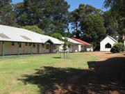
The following is an extract from the Heritage Council of WA’s Assessment Documentation for the place: Margaret River Hotel (1936), a two storey rendered brick and tile building located in the Margaret River town centre exhibiting elements of the Inter-War Old English style, together with evidence of the influence of the Inter-War Art Deco and Arts and Crafts styles, with substantial extensions built in 1985, has cultural heritage significance for the following reasons: • the place’s initial and continued development has been closely associated with major developments in the region, in the first instance Group Settlement, tourism to the caves, and the development of viticulture in the region in the late twentieth and early twenty-first centuries; • the 1936 hotel building is a rare and good example of the Inter-War Old English architectural style with elements of the Inter-War Art Deco and Arts and Crafts styles, designed and executed to high standards externally and internally; • the place is a fine example of the work of architect F.G.B. Hawkins, and builder, C.W. Arnott, both highly accomplished in their respective fields; • the place was the second hotel built in the Shire of Augusta-Margaret River, and has been an integral part of the town of Margaret River and the district, both physically and socially, since 1936; and, • the place was built for Bernard McKeown, whose family became significant local identities and continued to own and operate the hotel for 36 years. The 1985 additions to the Margaret River Hotel are of little cultural heritage significance in their own right. They are, however, in keeping with the original design style of the hotel and are not intrusive.
The following description is based on extracts from the Heritage Council’s Assessment documentation for the place. A more detailed description is available at www.heritage.wa.gov.au: Margaret River Hotel is a two storey rendered brick and tile building that exhibits elements of the Inter-War Old English architectural style together with evidence of the influence of the Inter-War Art Deco and Arts and Crafts styles in both its architectural composition and detailing. The original (1936) portion of Margaret River Hotel is L shaped in plan and comprises the northern portion of the building addressing Bussell Highway and the eastern wing that extends into the carpark area to the rear of the building. The southern portion of the building addressing Bussell Highway was added in 1985, together with the single storey bottle shop. At the front of the building the front setback contains a series of outdoor courtyards. On the northern end of the building, at the corner of Willmott Avenue and Bussell Highway, is a beer garden enclosed behind a painted rendered masonry boundary wall with masonry piers. The external fabric of the building comprises painted and rendered masonry walls, autumn blend coloured terracotta roof tiles, timber joinery to the 1936 section and metal framed windows to the more recent sections of the building. The hotel was originally constructed of face brickwork but was rendered and painted following the 1985 works. The tiled roof is hipped with half-timbered gables. There are three gables on the main western facade, two to the 1936 section and one to the 1985 section of the building. On the eastern side there is a gable to the roof of the original eastern wing, another to the roof of the single storey bottle shop and a third to the main roof of the two storey southern addition. The roof has two large chimneys on the east, one on the north and one on the west elevation of the 1936 section. These are rendered masonry and simply proportioned with a suggestion of Art Deco design influence in their design and proportions. There is a similarly detailed chimney on the west elevation of the 1985 addition. There are two large balconies at first floor level on the western elevation of the 1936 building. These are heavily proportioned with solid masonry balustrade walls, with vertical banding decoration to the northernmost balcony, and pairs of timber posts supporting the tiled gabled roofs above. The building has covered verandahs on the northern and western facades over the beer garden and along the front of the building in front of the new bar area. These are not original, but are reconstructions to original detail carried out in 1985. The interior of the building is finely detailed with elements that derive from the Arts and Crafts style evident particularly in the detail of fireplaces in the lounge and dining room on the ground floor and in the first floor sitting room.
Bernard McKeown, the original owner and manager of the Margaret River Hotel, purchased lots 17 to 20, building the hotel on 19 and 20. McKeown’s wife Sarah, and family helped him run the hotel, which was officially opened on 11 April 1936. As the Hotel was built prior to electricity being supplied to the town, the hotel originally ran from a semi-diesel powered generator. Cool drinks for the hotel and for retail sale were made in the hotel yard, where a small aerated water plant was housed in a shed. There was also a hotel truck, which would meet guests at the railway station and transport them to the hotel. In 1985, seven new motel units and extensions were built and the whole building was rendered. More modifications and renovations were undertaken in 2001/2002. As at 2012, the place is still a Hotel and is a landmark in the main street of Margaret River. For more detail on the history of the Hotel since its construction in 1936, see the HCWA Assessment Documentation.
High: The original use has been maintained. Medium: The place has had some alterations, but the original intent/character is still clearly evident.
Good *Assessed from streetscape survey only
| Name | Type | Year From | Year To |
|---|---|---|---|
| F G B Hawkins | Architect | - | - |
| Ref ID No | Ref Name | Ref Source | Ref Date |
|---|---|---|---|
| Cresswell, Gail J,The Light of Leeuwin:the Augusta/Margaret River Shire History | Augusta/Margaret River Shire History Group | 1989 | |
| Margaret River Hotel (00108). | HCWA Assessment Documentation | ||
| Municipal Heritage Inventory | 1996 |
| Ref Number | Description |
|---|---|
| A5670 | LGA Site No. |
| MR(T)-08 | MI Place No. |
| Reserve | Lot/Location | Plan/Diagram | Vol/Folio |
|---|---|---|---|
| 1 |
This information is provided voluntarily as a public service. The information provided is made available in good faith and is derived from sources believed to be reliable and accurate. However, the information is provided solely on the basis that readers will be responsible for making their own assessment of the matters discussed herein and are advised to verify all relevant representations, statements and information.
27 Tunbridge St Margaret River
Margaret Cecil Building, Nurses Quarters
Margaret River Resource Centre
Augusta/Margaret River
South West
Constructed from 1924 to 1990
| Type | Status | Date | Documents |
|---|---|---|---|
| Heritage List | Adopted | 08 Aug 2012 | |
| State Register | Registered | 06 Sep 1996 | HCWebsite.Listing+ListingDocument, HCWebsite.Listing+ListingDocument |
| Type | Status | Date | Documents |
|---|---|---|---|
| (no listings) |
| Type | Status | Date | Grading/Management | |
|---|---|---|---|---|
| Category | ||||
| Municipal Inventory | Adopted | 01 Jul 2012 | Exceptional Significance | |
| Municipal Inventory | Adopted | 17 Jun 1996 | Criterion 3A | |
| Library Id | Title | Medium | Year Of Publication |
|---|---|---|---|
| 3798 | Conservation Plan for the Old Margaret River Hospital | Heritage Study {Cons'n Plan} | 1997 |
| 11872 | The Old Margaret River Hospital | Heritage Study {Cons'n Plan} | 2021 |
Individual Building or Group
| Epoch | General | Specific |
|---|---|---|
| Original Use | HEALTH | Housing or Quarters |
| Present Use | SOCIAL\RECREATIONAL | Other Community Hall\Centre |
| Original Use | HEALTH | Hospital |
| Style |
|---|
| Federation Bungalow |
| Type | General | Specific |
|---|---|---|
| Roof | METAL | Corrugated Iron |
| Wall | TIMBER | Weatherboard |
| General | Specific |
|---|---|
| SOCIAL & CIVIC ACTIVITIES | Community services & utilities |
| DEMOGRAPHIC SETTLEMENT & MOBILITY | Settlements |
This information is provided voluntarily as a public service. The information provided is made available in good faith and is derived from sources believed to be reliable and accurate. However, the information is provided solely on the basis that readers will be responsible for making their own assessment of the matters discussed herein and are advised to verify all relevant representations, statements and information.
Constructed from 1924, Constructed from 1990
The following is an extract from the Heritage Council of WA’s Assessment Documentation for the place: Old Hospital Complex, comprising: the Hospital Building (1924), the Doctor's Surgery (1925), Margaret Cecil Rest House (1929) and the Nurses' Quarters (1929); all timber framed buildings clad with Jarrah weatherboard and roofed with corrugated iron; other ancillary buildings and bushland setting, has cultural heritage significance for the following reasons: • the place forms an historical precinct which facilitates an understanding of the development of the region; • the place is representative of buildings constructed during the period of the group settlement era; • the place reinforces the image of Margaret River and represents a link with the original character of a town in a forest; and, • Margaret Cecil Rest House is of historical importance for its close association with the provision of services to women who pioneered the development of the south-west in the 1920s.
The following description is based on extracts from the Heritage Council’s Assessment documentation for the place. A more detailed description of the place and its component parts is available at www.heritage.wa.gov.au: There are seven single storey buildings within Old Hospital Complex. Three of the earlier buildings face Tunbridge Street and the other buildings are grouped in an informal manner behind. Old Hospital Complex comprises: • the Hospital Building [1924], - a single storey weatherboard cottage costing £1,100 • the Doctor's Surgery and Residence [1925], - a four room cottage built for Dr Rigby • Margaret Cecil Rest House [May 1929], - a single storey weatherboard cottage which cost £1,200 funded by the 'Margaret's of Britain' • the Nurses' Quarters [December 1929] • alterations [1930s] to the hospital building added an operating theatre and dining room wing • the matron's residence [1930s] included additions to the nurses quarters • several additions to the Hospital and Margaret Cecil Rest House occurred but no details are available, this includes the morgue, orderlies room and drying shed • alterations [1951] added a children's ward to the main building • alterations [1965] added toilet facilities to the main building • the laundry building [early 1970s] is a red brick, flat roofed building that replaced an old laundry of which no details are available • alterations [1975] to the hospital building added a birth suite and boiler room • alterations [1975] to the Margaret Cecil building added ablutions and other facilities for permanent care of the aged • alterations [1993] to all buildings occurred to facilitate community usage The Hospital building (west), the Doctor's Surgery (centre) and Nurses' Quarters (east) were all built with a similar (7.5 - 9 metre) setback from Tunbridge Street, with the Margaret Cecil Rest House , laundry, drying shed and morgue all located behind (south) the hospital building. The four main buildings (Hospital, Surgery, Nurses Quarters and Margaret Cecil Rest House) and the morgue are similar in style and construction to other buildings from the group settlement era which used local jarrah for framing, flooring, weatherboards and skirtings. Roofs are galvanised iron and internal wall linings are either plasterboard, masonite or cement sheeting with battens. The style of the buildings could best be described as 'Victorian-Federation Carpenter Bungalow' although the economy in construction of the original buildings and the naivety of the builders construction technique produced a vernacular that has either deleted or modified the usual features of this style.
In 1922, following the establishment of a group settlement in the Margaret River district, the local Progress Association approached the Health Department on the subject of securing a doctor for their district, as the nearest medical aid was Busselton. In order to facilitate this, a medical scheme was established whereby settlers contributed one shilling per week. Before a medical officer was appointed the local MLA, Mr Pickering, approached the Health Department to discuss a hospital for the district. The department agreed to provide a hospital on a pound for pound basis, but advised that first the district must establish a medical officer. In August 1923, Dr Rigby was appointed as District Medical Officer and not long after the Health Department had their principal architect draw up plans for a weatherboard cottage hospital. The estimate submitted by the architect was for ₤1100 and the building of the hospital was completed in May 1924.In December 1929, additional nurses’ quarters was provided, a new dining room was added in the 1930s, as well as an extra bathroom for nurses, an operating theatre accommodation and sterilising facilities. These additions were funded by the Lotteries Commission, State Government and the community.An important addition to the hospital occurred in 1929. This was the Margaret Cecil Rest House, which was built at the rear of the hospital. The rest house was named for Lady Alicia Cecil and her daughter, Margaret, who upon visiting the district found the facilities for pregnant women inadequate. When Lady Alicia and Margaret returned to England, Margaret sent out an appeal to the ‘Margarets of Britain’ to support a fund for a Rest House in Margaret River. In her letter she wrote:.by voluntary effort these rest houses have been built in other Group Settlement centres. If the Margarets of England and Scotland would build the one in Margaret River, not only would it be the greatest help to the mothers, but it would be a tangible link of Empire which Australians would appreciate and it would make the families feel that those in the old country had not forgotten them.Money was also raised by card evenings and the sale of some of the water colours done by Margaret Cecil.Trustees were appointed in the Margaret River district to oversee the building of the rest house and the expenditure of funds, and a committee of ladies was organised to raise funds and maintain the building. The house was furnished and fully equipped, linen, blankets were sent from England, as well as a complete monogrammed dinner set, books and a gramophone. Even during the war years Margaret Cecil (later Mrs Lane) sent food parcels for distribution, and continued her association with the Rest House until her death in 1963.By the 1960s it was realised that a new hospital building was required. After much discussion between the government, the hospital, the shire and community groups – lasting nearly three decades – work finally commenced on the new hospital in 1989.The Margaret River Community Resource Centre Inc. had its genesis in theMargaret River Community Resource Centre (Inc) at 1 Station Road, Margaret River. It was established in 1985 to service the region’s high proportion of pensioners, unemployed, single parents, children and community groups, the vast majority of whom are women. However it soon became apparent that the resources were inadequate to meet the needs of one of the fastest growing areas of Western Australia. A group of 40 people, including representatives of the community resource centre and 12 other community groups, formed the resource centre in January 1990 with the purpose of obtaining and maintaining the soon to be vacated old hospital site in Tunbridge St, for community purposes. After much negotiation with various government bodies the old hospital site was secured under a vesting order to the Augusta/Margaret River Shire for community purposes on 7 February 1991. The resource centre in fact began leasing the site from the interim responsible body – the South West Development Authority – on 1 September 1990. On 26 June 1991 the community resource centre and the resource centre were amalgamated. The new resource centre rents the site from the Shire Council.
Medium: The use has been altered, but the original use is still evident through interpretation of the fabric. Medium: The place has had some alterations, but the original intent/character is still clearly evident
Good *Assessed from streetscape survey only
| Name | Type | Year From | Year To |
|---|---|---|---|
| Linton Hodsdon | Architect | - | - |
| Ref ID No | Ref Name | Ref Source | Ref Date |
|---|---|---|---|
| Municipal Heritage Inventory | 1996 | ||
| Old Hospital Complex, Margaret River (03314) | HCWA Assessment Documentation | ||
| Cresswell, Gail J, The Light of Leeuwin: the Augusta/Margaret River Shire History | The L Augusta/Margaret River Shire History Group | 1989 |
| Ref Number | Description |
|---|---|
| MR(T)-13 | MI Place No. |
| A4947 | LGA Site No. |
| Reserve | Lot/Location | Plan/Diagram | Vol/Folio |
|---|---|---|---|
| 295 |
This information is provided voluntarily as a public service. The information provided is made available in good faith and is derived from sources believed to be reliable and accurate. However, the information is provided solely on the basis that readers will be responsible for making their own assessment of the matters discussed herein and are advised to verify all relevant representations, statements and information.

187 Wallcliffe Rd Margaret River
Augusta/Margaret River
South West
Constructed from 1912 to 1980
| Type | Status | Date | Documents |
|---|---|---|---|
| Heritage List | Adopted | 08 Aug 2012 | |
| State Register | Registered | 07 Oct 1997 | HCWebsite.Listing+ListingDocument, HCWebsite.Listing+ListingDocument |
| Type | Status | Date | Documents |
|---|---|---|---|
| (no listings) |
| Type | Status | Date | Grading/Management | |
|---|---|---|---|---|
| Category | ||||
| Classified by the National Trust | Classified | 01 May 1978 | ||
| Restrictive Covenant | YES | |||
| Register of the National Estate | Permanent | 21 Oct 1980 | ||
| Municipal Inventory | Adopted | 17 Jun 1996 | Criterion 1 | |
| Municipal Inventory | Adopted | 01 Jul 2012 | Exceptional Significance | |
| Library Id | Title | Medium | Year Of Publication |
|---|---|---|---|
| 489 | Buildings places and things of national or local importance in the Shire of Augusta-Margaret River. | Report | 1975 |
| 7612 | Proposed Farm Stay accommodation Lot 100 Wallcliffe Road, Margaret River, Shire of Augusta-Margaret River : Development Application. | Report | 2005 |
| 482 | Historical sites in the Margaret River Augusta region : a photographic survey of documented and undocumented historical sites in the region carried out by students of the University of Western Australia, Department of Architecture. | Heritage Study {Other} | 1980 |
| 3144 | Basildene : conservation plan. | Heritage Study {Cons'n Plan} | 1997 |
| 7189 | Very much on watch : the Percy Willmott photos : Augusta, Margaret River, Busselton 1901 - 1919. | Book | 2003 |
Individual Building or Group
| Epoch | General | Specific |
|---|---|---|
| Present Use | RESIDENTIAL | Two storey residence |
| Original Use | FARMING\PASTORAL | Homestead |
| Present Use | COMMERCIAL | Restaurant |
| Present Use | COMMERCIAL | Hotel, Tavern or Inn |
| Style |
|---|
| Victorian Georgian |
| Type | General | Specific |
|---|---|---|
| Roof | METAL | Corrugated Iron |
| Wall | STONE | Local Stone |
| Roof | METAL | Tin |
| Wall | TIMBER | Other Timber |
| General | Specific |
|---|---|
| OCCUPATIONS | Hospitality industry & tourism |
| DEMOGRAPHIC SETTLEMENT & MOBILITY | Technology & technological change |
| TRANSPORT & COMMUNICATIONS | River & sea transport |
This information is provided voluntarily as a public service. The information provided is made available in good faith and is derived from sources believed to be reliable and accurate. However, the information is provided solely on the basis that readers will be responsible for making their own assessment of the matters discussed herein and are advised to verify all relevant representations, statements and information.
Constructed from 1912, Constructed from 1980
The following is an extract from the Heritage Council of WA’s Assessment Documentation for the place: Basildene Farmhouse, a two-storey stone house with modern ground floor extensions, has cultural heritage significance for the following reasons: • the place is highly valued by the community in its own right and for its potential tourist value; • the place has aesthetic value in its harmonious proportions and generous volumes • the place has historic significance because of its association with several generations of the farming Willmott family; • the place demonstrates excellence in design and workmanship in the jarrah staircase and the large central hall; and, • the building contributes to the community's sense of place. The 1980 ground floor extensions are of little heritage significance.
The following is based on extracts from the Heritage Council of WA’s Assessment Documentation for the place. A more detailed description of the interior and exterior is available online at www.heritage.wa.au: Basildene Farmhouse is located in a small, steep valley on the south side of Wallcliffe Road, about 1.5km from the township of Margaret River and 200m east of Yalgardup Creek.Basildene Farmhouse was built in two stages. The original house was built in 1912 in the Victorian Georgian style. Large extensions were built in the late twentieth/early twenty-first century (relating to its use as a guest house).The construction of the original house is as follows. The floor construction consists of timber floorboards, probably on traditional bearers and stumps. The walls are of random stone. The haunched sashes of the double hung timber windows are divided into two panes each. Windows and doors have stucco surrounds.The design of the roof is such that the ridge line is parallel to the east, north and west external walls giving the appearance of a normal hipped roof. However, when viewed from the south or rear of the building, two box gutters and three separate hipped roofs are evident. The boxed gutters run north-south and are located over the southern part of the east and west walls of the central hallway.
The following is an extract from the Heritage Council of WA’s Assessment Documentation for the place: Basildene Farmhouse was built in 1912 by William Henry Percival Willmott, who was commonly known as Percy. Willmott became the first Head Lightkeeper of Cape Leeuwin Lighthouse when it was completed in 1895 and spent fourteen years in that capacity, residing with his wife and growing family in one of the lighthouse cottages, before taking up land at Margaret River. Sussex Location 632 on Yalgardup Brook was originally surveyed in December 1908 for T.E. Higgins who initially took up the land under Conditional Purchase Lease 18736/55. Records cannot be located detailing the transfer of this lease to Willmott, but this probably took place about 1910 when he reputedly moved onto the property. The family are said to have lived in a shack made from flattened kerosene tins while they cleared the land and decided where to build.In 1911, the family sailed for England where they spent twelve months holidaying and visiting relatives. It was during this period that Willmott is thought to have designed the house he planned to build on his Margaret River land. The design was based on a relative's property near Reading called 'Basildon'. On his return to Western Australia, Willmott engaged Yallingup builder Robert Donald to construct his house, a two-storey edifice with four rooms upstairs and four downstairs. It was built of local stone and locally milled jarrah and karri timber with a jarrah staircase leading to the upper rooms. The large central hallway occupying a two-storey space in the centre of the building was a distinctive feature of the design.Percy Willmott died in February 1920. Willmott's descendants continued to live there and farm the property, which eventually passed into the hands of his grandson, Ross Willmott, in 1972.The house was classified by the National Trust in 1978. In 1984, Basildene Farmhouse was sold for $850 000 to Amberwave Pty Ltd, a subsidiary of the Colonial Development Corporation. This company announced plans for restoration of the building, which was to be converted to a BYO restaurant and holiday accommodation. In 1991, Basildene Farmhouse was purchased by Ron and Kay Macfarlane who commenced renovations which were completed in 1992. The main changes made to the building at that time were the addition of ensuites to each guest room.In 1997 the place was added into the HCWA Register of Heritage Places. A ‘Heritage Wing’ was later added featuring Courtyard Suites with enclosed patios, and Balcony/Lakeview Suites with private balconies, overlooking farmlands, the lake and gardens. As at 2012, the place is ‘Grand Mecure Basildene Manor.’
Medium: The use has been altered, but the original use is still clearly evident through interpretation of the fabric. Medium: The place has had some alterations, but the original intent/character is still clearly evident.
Good *Assessed from streetscape survey only
| Ref ID No | Ref Name | Ref Source | Ref Date |
|---|---|---|---|
| Basildene Manor | http://www.basildene.com.au | ||
| Basildene Farmhouse (00107) | HCWA Assessment Documentation | ||
| Municipal Heritage Inventory | 1996 | ||
| Cresswell, Gail J, The Light of Leeuwin: the Augusta/Margaret River Shire History | Augusta/Margaret River Shire History Group | 1989 |
| Ref Number | Description |
|---|---|
| A1029 | LGA Site No. |
| MR(L)-01 | MI Place No. |
| Reserve | Lot/Location | Plan/Diagram | Vol/Folio |
|---|---|---|---|
| 100 |
This information is provided voluntarily as a public service. The information provided is made available in good faith and is derived from sources believed to be reliable and accurate. However, the information is provided solely on the basis that readers will be responsible for making their own assessment of the matters discussed herein and are advised to verify all relevant representations, statements and information.

Wallcliffe Rd Prevelly
Wallcliffe
Augusta/Margaret River
South West
Constructed from 1865
| Type | Status | Date | Documents |
|---|---|---|---|
| Heritage List | Adopted | 08 Aug 2012 | |
| State Register | Registered | 26 Aug 2005 | HCWebsite.Listing+ListingDocument, HCWebsite.Listing+ListingDocument |
| Type | Status | Date | Documents |
|---|---|---|---|
| (no listings) |
| Type | Status | Date | Grading/Management | |
|---|---|---|---|---|
| Category | ||||
| Register of the National Estate | Permanent | 21 Mar 1978 | ||
| Aboriginal Heritage Sites Register | Permanent | |||
| Aboriginal Heritage Sites Register | Interim | |||
| Classified by the National Trust | Classified | 16 Dec 1976 | ||
| Municipal Inventory | Adopted | 17 Jun 1996 | Criterion 1 | |
| Municipal Inventory | Adopted | 01 Jul 2012 | Exceptional Significance | |
The house was substantially destroyed by fire in 2011
| Name | Type | Year From | Year To |
|---|---|---|---|
| Bussell, A.P. | Architect | - | - |
| Library Id | Title | Medium | Year Of Publication |
|---|---|---|---|
| 489 | Buildings places and things of national or local importance in the Shire of Augusta-Margaret River. | Report | 1975 |
| 482 | Historical sites in the Margaret River Augusta region : a photographic survey of documented and undocumented historical sites in the region carried out by students of the University of Western Australia, Department of Architecture. | Heritage Study {Other} | 1980 |
| 3666 | Wallcliffe : conservation plan. + Annexure by Marcus Collins Architects. | Heritage Study {Cons'n Plan} | 1998 |
| 471 | Ellensbrook | Heritage Study {Other} | 198 |
| 12302 | Wallcliffe House - archaeological management plan | Heritage Study {Other} | 2025 |
| 9694 | Assessment of the Wallcliffe landscape, Wallcliffe Road, Prevelly. | Heritage Study {Other} | 2004 |
Individual Building or Group
| Epoch | General | Specific |
|---|---|---|
| Original Use | FARMING\PASTORAL | Homestead |
| Present Use | FARMING\PASTORAL | Homestead |
| Style |
|---|
| Victorian Georgian |
| Type | General | Specific |
|---|---|---|
| Wall | STONE | Limestone |
| Roof | TIMBER | Shingle |
| Roof | METAL | Corrugated Iron |
| Wall | STONE | Limestone |
| Roof | TIMBER | Shingle |
| General | Specific |
|---|---|
| DEMOGRAPHIC SETTLEMENT & MOBILITY | Environmental change |
| DEMOGRAPHIC SETTLEMENT & MOBILITY | Workers {incl. Aboriginal, convict} |
| PEOPLE | Early settlers |
| OUTSIDE INFLUENCES | Tourism |
| DEMOGRAPHIC SETTLEMENT & MOBILITY | Racial contact & interaction |
| DEMOGRAPHIC SETTLEMENT & MOBILITY | Aboriginal Occupation |
| OCCUPATIONS | Grazing, pastoralism & dairying |
This information is provided voluntarily as a public service. The information provided is made available in good faith and is derived from sources believed to be reliable and accurate. However, the information is provided solely on the basis that readers will be responsible for making their own assessment of the matters discussed herein and are advised to verify all relevant representations, statements and information.
Constructed from 1865
The following is an extract from the Heritage Council of WA’s Assessment Documentation for the place: Wallcliffe House & Landscape, consisting of Wallcliffe House, a two storey stone, shingle and corrugated iron homestead designed in the Victorian Georgian style, remaining outbuildings and designed landscape setting, together with the adjacent Bushland, Wallcliffe Cliffs, Wallcliffe Cave and the Bushland Scarp on the northern side of Margaret River which represents the original view from the property,has cultural heritage significance for the following reasons: • the place is important in bringing together a diverse range of exceptional elements significant for their Aboriginal, European and natural values; • the place is a site of great beauty. The attractive natural landscape first drew settlers to this area and many of the views and vistas have changed little since the start of European settlement. The picturesque siting of Wallcliffe House marks a European influence on the landscape, without intruding on the natural magnificence of the site; • the establishment of the dairy and pastoral industries at Wallcliffe House & Landscape by the women of the Bussell family represents the important role that women played in the early rural development of the Colony; • Wallcliffe House is an excellent and well-crafted example of a Victorian Georgian homestead, and its design represents the aspiration of many early colonists to emulate a British country gentleman’s residence. It is rare as a two-storey residence of this type constructed in stone; • the place marks the beginning of agricultural development in the Margaret River region and was the focus of the pioneering agricultural enterprise of the family of Alfred and Ellen Bussell; • Wallcliffe House is a distinct and important landmark due to its isolated location and the contrast of its limestone walls against the darker bushland vegetation; • the place has long associations with the Terry and Hohnen families, each long standing families in the Margaret River community and in WA business circles; and, • the place demonstrates changes in land use and agricultural practices, and the economic fortunes of owners from first settlement to the present time. Note: In November 2011 the house bushfires gutted the building, leaving only the ruins of the walls standing. However, its significance remains embodied in its important historical associations and through an interpretation of the surviving fabric.
Prior to the 2011 bushfire Wallcliffe House was noted an excellent example of a homestead in the Victorian Georgian style. It displayed considerable finesse in its siting and design against a backdrop of bushland and limestone cliffs, and in the materials and level of craftsmanship employed in its original construction and restoration. A detailed description of the place prior to the fire is included in ‘Wallcliffe Conservation Plan’ (prepared by Hocking Planning & Architecture in association with Barbara Dundas, on behalf of M. A. & C. A. Hohnen (1998).As at February 2012 some walls and chimneys stand as part of an extensively damaged ruin.
Wallcliffe was a stately residence situated above the bank of the Margaret River, about one kilometre from where it enters the sea. The house was built for Alfred and Ellen Bussell, and was imposing with six large stone chimneys, limestone walls, wide verandas and cellars. Downstairs included a large kitchen, dining, reception and music rooms. The upstairs bedrooms featured protruding alcoves overlooking the river. The house had a shingle roof and jarrah floorboards. Wallcliffe was the second house built in the Margaret River area, the first being Ellensbrook, which was also built by Alfred Bussell. By 1858, their first home, Ellensbrook could no longer cope with the number of residents and stock, so Alfred decided to build a larger house on a new site. The site chosen was south of Ellensbrook. It took many years to build, not only because of its size, but also because the Bussells had to fit in their normal farm duties. The limestone used was quarried from the Margaret River bank and the chalk was quarried near Gnarabup. The original timber shingle roof has since been replaced by sheet shingles. After nearly eight years, Wallcliffe was finally ready, and in 1865 the family shifted in. Ellen Bussell had built a dairy at Wallcliffe, which was eventually turned into a restaurant. One important part of Wallcliffe's history was that it was the house that the survivors from the ‘Georgette’ were taken, after being rescued by Grace Bussell and Sam Isaacs. After the death of Alfred Bussell in 1882 the estate was left to John and Fred Bussell, with Fanny managing it until John reached the age of 23 years. Fanny stayed on for approximately seven years, but the estate was later broken up and sold out of the Bussell family.After the Union Bank foreclosed on the Bussell Brothers, Wallcliffe was leased and then sold, in 1902, to A C Loaring and N McLeod. Loaring and McLeod ran the property as a farm, but also operated the house as a guesthouse. This business expanded as more tourists came to the area following the opening of the caves to the public. It was not until 1910 that Wallcliffe came back into the Bussell family, when Marmaduke Terry bought it from Loaring and McLeod for his wife Filumena Bussell. Unfortunately they could not secure all of the original property, mainly because of the mismanagement of John Bussell previously, who lost much of the original lease to the Government. When Terry purchased the property 29,000 acres of leasehold land reverted to the State, but the two partners retained 1,500 acres of freehold and conditional purchase land. Filumena and Marmaduke only secured some of the original property, which was Class A reserve lease of 1000 acres of coastal land. It was after this that a further 800 acres were added to the estate, as well as 200 acres bought by Filumena, which eventually became the part of the estate known as Garthowen. In this time the shingles were replaced with corrugated iron. Upon the death of Marmaduke in 1932, his son, Brian, ran the property.In early 1953, returned soldier Geoffrey Edwards and his wife purchased a southern coastal portion of the Wallcliffe property from the Terrys to establish a caravan park and holiday ‘resort’. Initially this consisted of only 30 acres, and was little more than a few tent sites. Later the land holding was increased, holiday cabins built, and a caravan park established. The access road, a fishing track that also serviced Wallcliffe House, was gradually improved, and tourist numbers in the area increased. In the early 1960s, the Edwards began to subdivide their land, and the settlement of Prevelly was established on land that had formerly been part of Wallcliffe. Sometime in the 1970s the dairy was converted into a restaurant.The Terrys sold the property in 1987 to Mark & Catherine (Cate) Hohnen. Mark was a founding member of Margaret River Land Holdings Ltd, a prominent Western Australian businessman and head of a hotel chain in the 1980s, and a significant investor in and developer of the Margaret River Area. In 1970, he and his brother David established the local Cape Mentelle Wines, one of the earliest commercial vineyards to operate in an area that has come to be characterised by this industry. In 1998, a conservation plan followed by a program of restoration and adaptation of Wallcliffe House was undertaken. The works were awarded a Royal Australian Institute of Architects Award for Conservation. Mrs Rosemary Chaney purchased Wallcliffe from the Hohnens in November 2001. Michael Chaney, a leading Australian businessman andNAB Chairman, built a new house and workshop adjacent to the house in a similar style, including the use of shingles for the roof. Wallcliffe House continued to be used as a residence, with the former dairy adapted for use as a guest house and occasional meeting room.On 23-24 November 2011, Wallcliffe House was extensively damaged in bushfire which destroyed over 30 properties in the Prevelly area. Also lost was a large collection of hand crafted jarrah furniture originally owned by the Bussell family, lithographs, water colours and historic papers.
Medium: The use has been altered, but the original use is still clearly evident through interpretation of the fabric. Low: The place has been considerably altered through the extensive damage caused by the 2011 bushfire, with major loss of significant fabric.
Poor (ruin)
| Ref ID No | Ref Name | Ref Source | Ref Date |
|---|---|---|---|
| Municipal Heritage Inventory | 1996 | ||
| Terry, Frances They Came to the Margaret (Southwest Printing & Publishing,Bunbury | 1978 | ||
| Cresswell, Gail J, The Light of Leeuwin: the Augusta/Margaret River Shire History | Augusta/Margaret River Shire History Group | 1989 | |
| Wallcliffe House and Landscape (0114) | HCWA Assessment Documentation | ||
| MA & CA Hohnen | Hocking Planning and Architecture Wallcliffe Conservation Plan | 1998 | |
| Augusta Margaret River Mail | online | 7/12/2011 | |
| Judi Price, ‘The History of Wallcliffe, Margaret River,’ Thesis | RWAHS Lee Steere Competition entry | 1967 |
| Ref Number | Description |
|---|---|
| PR-02 | MI Place No. |
| A9395 | LGA Site No. |
| Reserve | Lot/Location | Plan/Diagram | Vol/Folio |
|---|---|---|---|
| 101 |
This information is provided voluntarily as a public service. The information provided is made available in good faith and is derived from sources believed to be reliable and accurate. However, the information is provided solely on the basis that readers will be responsible for making their own assessment of the matters discussed herein and are advised to verify all relevant representations, statements and information.

3 Redgate Rd Witchcliffe
Fearn's Cash Store
Augusta/Margaret River
South West
Constructed from 1927 to 1928
| Type | Status | Date | Documents |
|---|---|---|---|
| Heritage List | Adopted | 08 Aug 2012 | |
| State Register | Registered | 05 Jan 2001 | HCWebsite.Listing+ListingDocument, HCWebsite.Listing+ListingDocument |
| Type | Status | Date | Documents |
|---|---|---|---|
| (no listings) |
| Type | Status | Date | Grading/Management | |
|---|---|---|---|---|
| Category | ||||
| Municipal Inventory | Adopted | 17 Jun 1996 | Criterion 2 | |
| Municipal Inventory | Adopted | 01 Jul 2012 | Exceptional Significance | |
The seed store at Darnells Store at Witchcliffe has collapsed. It appears that the building has collapsed of its own accord. The owner that the notice on the building will now be removed. Kim Luciano, Shire of Augusta Margaret River.
| Library Id | Title | Medium | Year Of Publication |
|---|---|---|---|
| 8885 | Darnell's General Store, Witchcliffe. Conservation works. | Conservation works report | 2007 |
Individual Building or Group
| Epoch | General | Specific |
|---|---|---|
| Original Use | SOCIAL\RECREATIONAL | Other Community Hall\Centre |
| Present Use | COMMERCIAL | Shop\Retail Store {single} |
| Original Use | COMMERCIAL | Shop\Retail Store {single} |
| Style |
|---|
| Vernacular |
| Type | General | Specific |
|---|---|---|
| Wall | TIMBER | Weatherboard |
| Roof | METAL | Corrugated Iron |
| General | Specific |
|---|---|
| TRANSPORT & COMMUNICATIONS | Mail services |
| DEMOGRAPHIC SETTLEMENT & MOBILITY | Settlements |
| DEMOGRAPHIC SETTLEMENT & MOBILITY | Immigration, emigration & refugees |
This information is provided voluntarily as a public service. The information provided is made available in good faith and is derived from sources believed to be reliable and accurate. However, the information is provided solely on the basis that readers will be responsible for making their own assessment of the matters discussed herein and are advised to verify all relevant representations, statements and information.
Constructed from 1927
The following is an extract from the Heritage Council of WA’s Assessment Documentation for the place: Darnell’s General Store, a group of buildings comprising a retail store, with two w.c.'s, a chemical store (former single men's quarters), and a seed store, all constructed of timber, with iron roofs, with floors and verandahs of timber, and retaining much of the early fitout and examples of stock on display, has cultural heritage significance for the following reasons:• the place exhibits the aesthetic characteristics of a simple vernacular collection of buildings typical of the modest structures built in Group Settlement hamlets and timber towns in the South-West of Western Australia. Its simple underlying design overlaid with alterations, wear and tear, and decay, make the place a visually rich experience. It is its ordinariness, the adaptations, and patination that give it much of its aesthetic interest and is very much a part of its significance; • the place has a high degree of integrity and authenticity and is an integral part of a South-West hamlet, where almost all the buildings are simple timber framed structures; • the place is a fine representative example of building construction associated with timber towns and Group Settlements; • the place is a good representative example of a mode of trading that was once common in the late nineteenth century to the middle of the twentieth century, but is now rare, where goods and services were offered over the counter and from display cabinets by sales assistants; • the early period fitout and stock has been retained on display to reinforce the 'old fashioned character and charm' of the place; • the place was constructed in 1927, and was associated with the Group Settlement Scheme in Western Australia following World War One; • the place was owned and run by George Shervington and Bill Darnell, the joint owners of the place from 1941 to 1960, and following the death of Shervington, Bill Darnell as sole owner; and, • the place is highly valued by the community of the Shire of Augusta Margaret River, for the important role it has played in the development of the district. The carport attached to the former single men’s quarters, the present chemical store is considered to be of little significance.
The following is an extract from the Heritage Council of WA’s Assessment Documentation for the place. A more detailed description of the site and interior is available in that documentation. The store is rendered in a simple vernacular manner, occasionally using elements of the Federation Bungalow style, and comprises four major elements: the gable roofed main space, the two lean-to flanking spaces, and the verandah. The main store is a double volume timber framed structure with a gabled corrugated iron roof, without gutters and the roof runs along the north-south axis. Clerestories comprising fixed glass lights and translucent sheeting run the full length of the east and west flanks of the main building structure. The front of the building has a full-length verandah with a bitumen-paved floor, timber posts and a low pitched iron roof. The front of the shopfront is symmetrically disposed with a pair of glazed and panel doors at the centre flanked by large fixed glazed shop windows then double hung sash windows and two four panel doors, one leading into the post office and the other to the office. The whole of the front of the building is clad with painted jarrah weatherboards.The eastern and western flanks of the building are weatherboard clad and this cladding is in fair condition. The eastern side has few windows in it, and at a point midway along its length there is what remains of a brick oven, with the flue removed. The west elevation has a series of doors and windows along its length, with clear evidence of many alterations to the location and size of openings in the length of the elevation. There is a pair of sliding timber framed and boarded doors on the rear elevation.
In the early 1920s this area was closely settled as part of the Group Settlement Scheme (Group 57 – Witchcliffe and Group 72 - Walgine). During the same period a sawmill and mill settlement were established at Walgine (East Witchcliffe). On the 20th of October 1924, the government extended the railway from Margaret River to Witchcliffe to help service the saw mill. At first the siding was named Narawary but, as there was already a Post Office named Witchcliffe, the siding was renamed in February 1925.In 1924 interest was shown in blocks of land at Witchcliffe Siding, and after investigation a scheme of subdivision was planned, lots surveyed, and a townsite gazetted in 1926.On 27 June 1927, Lot 6 Witchcliffe was granted by the Crown to Thomas Hopson, storekeeper of Witchcliffe, for the sum of £20. In 1927 Hopson built a general store, post office, dance hall and meeting place to serve the small town of Witchcliffe and the nearby group settlements. The main building comprised a single-storey timber weatherboard building, with an iron roof supported by 40' karri beams, timber floors and a front verandah. It was built like a hay shed, with the stumps set down into the ground, and the timber floor resting on 5" timber bearers.There were no ceilings.The outbuildings included two timber and iron w.c.'s; single men's quarters; a store with a timber landing and a baker's oven.The store became the centre of community life for the small town of Witchcliffe and the surrounding district. The hall was used for dances; for picture shows; for roller skating; for Congregational Church services prior to the building of the church in 1933; and for the whole gamut of social events. Thomas Hopson died in 1930 and the business was then taken over by Mrs Vera Fearn and her mother Mrs Dolly, who rented the premises from Mrs Hopson.By 1937, the town of Witchcliffe had grown somewhat and there were a number of other stores in town including a Butcher, Grocery, Drapery, Fruit and Vegetable Store, and Refreshment Rooms. Bill Darnell with George Shervington took over Mrs. Mutton's store at Lot 7, renting the premises from Mrs. Tonkin.They had calculated that there were approximately 100 properties within a five mile radius of Witchcliffe, and therefore it was a worthwhile proposition. George Shervington ran the store at Witchcliffe, whilst Bill Darnell ran his other store at Rosa Brook (see Place # RB-01).In 1938, Vera Fearn, bought the building she had operated her store in since 1930. During World War two she also operated a Post Office from this site.In 1941, Bill Darnell and George Shervington purchased Fearn's Cash Store, which was subsequently re-named 'Darnell's General Store'. George Shervington ran Darnell’s General Store at Witchcliffe until his death in 1960. He was also active in the local community, serving as a member of the Augusta-Margaret River Roads Board, and as first president of the Rotary Club, which was founded in 1959-60.During the period 1941 to 1960, minor alterations were made to the interior of the store, comprising the construction of a wall between the retail portion of the store and the storage area to the rear, the construction of shelving and counters, and the central display cabinet, all constructed of top quality jarrah from the local timber mill.After George Shervington died Bill Darnell took over the running of the store at Witchcliffe, whilst his son, William H. (also known as ‘Bill’), ran Darnell's store at Rosa Brook. On 12 August 1998, the Augusta Margaret River Times reported that as a result of ill health Bill Darnell had to sell Darnell’s Trading Post and Post Office Witchcliffe, signalling the end of an era. It went on to state that the Witchcliffe Progress Association was working to form a co-operative to purchase the place, 'the town's landmark'. The sale of the place did not eventuate, but the business continued in operation for some time, with Bill Darnell regularly spending time there, and a number of people employed in the store as shop assistants.Bill Darnell passed away in November 2011. He was a loved and respected by the community of Witchcliffe and the Shire of Augusta- Margaret River, for his support through the tough times, for his service in his store, as postmaster of Witchcliffe for over 50 years, and as a member of the Roads Board for 33 years. As at 2012, the store is vacant.
Medium: The use has been altered, but the original use is still clearly evident through interpretation of the fabric. High: The original/significant fabric is largely intact.
Poor *Assessed from streetscape survey only
| Ref ID No | Ref Name | Ref Source | Ref Date |
|---|---|---|---|
| Municipal Heritage Inventory | 1996 | ||
| Darnell’s General Store (04946) | HCWA Assessment Documentation | ||
| Cresswell, Gail J, The Light of Leeuwin: the Augusta/Margaret River Shire History | The L Augusta/Margaret River Shire History Group | 1989 | |
| Unidentified newspaper clippings, 21 July 1991 | Margaret River Local History Collection Files. | 9/1998 | |
| Augusta Margaret River Times, | 12/8/1998 |
| Ref Number | Description |
|---|---|
| WI-01 | MI Place No. |
| A336 | LGA Site No. |
| Reserve | Lot/Location | Plan/Diagram | Vol/Folio |
|---|---|---|---|
| 6 |
This information is provided voluntarily as a public service. The information provided is made available in good faith and is derived from sources believed to be reliable and accurate. However, the information is provided solely on the basis that readers will be responsible for making their own assessment of the matters discussed herein and are advised to verify all relevant representations, statements and information.