Local Government
Augusta/Margaret River
Region
South West
Leeuwin Rd Cape Leeuwin
Augusta/Margaret River
South West
Constructed from 1896 to 1970
| Type | Status | Date | Documents |
|---|---|---|---|
| Heritage List | Adopted | 08 Aug 2012 | |
| Commonwealth List | YES | 22 Jun 2004 | |
| State Register | Registered | 13 May 2005 | HCWebsite.Listing+ListingDocument, HCWebsite.Listing+ListingDocument |
| Type | Status | Date | Documents |
|---|---|---|---|
| (no listings) |
| Type | Status | Date | Grading/Management | |
|---|---|---|---|---|
| Category | ||||
| Municipal Inventory | Adopted | 01 Jul 2012 | Exceptional Significance | |
| Municipal Inventory | Adopted | 17 Jun 1996 | Criterion 1 | |
| Classified by the National Trust | Classified | 02 Jun 1970 | ||
| Survey of 20th Ctry Architecture | Completed | 01 Mar 1988 | ||
| Register of the National Estate | Permanent | 21 Oct 1980 | ||
| Name | Type | Year From | Year To |
|---|---|---|---|
| George Temple Poole | Architect | - | - |
| Library Id | Title | Medium | Year Of Publication |
|---|---|---|---|
| 7189 | Very much on watch : the Percy Willmott photos : Augusta, Margaret River, Busselton 1901 - 1919. | Book | 2003 |
| 5195 | Opportunity to develop visitor accommodation, facilities and services at the Cape Leeuwin Lighthouse and Cape Naturaliste Lighthouse precincts : guidelines for submissions. | Report | 2001 |
| 3519 | Leeuwin lighthouse : a brief history. | Book | 1996 |
| 482 | Historical sites in the Margaret River Augusta region : a photographic survey of documented and undocumented historical sites in the region carried out by students of the University of Western Australia, Department of Architecture. | Heritage Study {Other} | 1980 |
| 5468 | Review of improvements to meet building code of Australia for the Cape Leeuwin and Cape Naturaliste lighthouses. | Report | 2001 |
| 3423 | Conservation plan : Cape Leeuwin Lightstation Western Australia. | Heritage Study {Cons'n Plan} | 1992 |
| 7183 | Lighthouses of Australia : images from the end of an era. | Book | 2001 |
| 8667 | Leeuwin Lighthouse Precinct site plan. | Heritage Study {Other} | 2006 |
Individual Building or Group
| Epoch | General | Specific |
|---|---|---|
| Original Use | Transport\Communications | Water: Lighthouse |
| Present Use | Transport\Communications | Water: Lighthouse |
| Type | General | Specific |
|---|---|---|
| Roof | METAL | Corrugated Iron |
| Wall | ASBESTOS | Fibrous Cement, flat |
| Wall | STONE | Limestone |
| Wall | STONE | Granite |
| General | Specific |
|---|---|
| OUTSIDE INFLUENCES | Water, power, major t'port routes |
| TRANSPORT & COMMUNICATIONS | River & sea transport |
| OCCUPATIONS | Timber industry |
| OUTSIDE INFLUENCES | Tourism |
This information is provided voluntarily as a public service. The information provided is made available in good faith and is derived from sources believed to be reliable and accurate. However, the information is provided solely on the basis that readers will be responsible for making their own assessment of the matters discussed herein and are advised to verify all relevant representations, statements and information.
Constructed from 1895
The following is an extract from the Heritage Council of WA’s Assessment Documentation for the place:Cape Leeuwin Lighthouse and Quarters, a small precinct which contains a stone lighthouse, keepers’ quarters (stone) and various service buildings, has cultural heritage significance for the following reasons:• the place is part of a system of coastal lights that was developed at the end of the nineteenth century by the various Australian colonies to improve the safety to shipping operating in Australian territorial waters. Although recognised as being of major importance to the eastern colonies, it was fully funded by the state government of Western Australia and the fourth coastal lighthouse constructed by the state government; • the place, in particular the lighthouse, has retained a high degree of authenticity and integrity; • the place has aesthetic value both in its design and as a striking landmark on Cape Leeuwin; • the place was historically important to the local timber industry which relied on small ships to transport the timber to other ports. As Cape Leeuwin could be treacherous in bad weather, the light was a valuable navigational aide; • the place represents a way of life that is no longer practised in Western Australia and one which is rapidly becoming scarce in other parts of Australia and the world; • the place has strong associations with John Forrest who tried for many years to establish a new light near Cape Leeuwin; with M.C. Davies, an important entrepreneur in Augusta, who pushed for a light on Cape Leeuwin and George Temple Poole who supervised the construction of the light and was responsible for the design of the keepers’ quarters; • the place is socially important to the people of Augusta-Margaret River for its tourist potential; • the place has the potential to reveal archaeological evidence about how people lived in isolated conditions; • the lighthouse is a fine example of the type of stone towers erected during the nineteenth century to house lights; and • the place at one time had the most powerful lamps in Australia and it was also the last to receive a modern tungsten lamp. While the new service buildings on the western side of the cottages are considered to have some historic importance, they are architecturally intrusive and are assessed as having low significance.
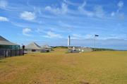
The following is an extract from the Heritage Council of WA’s Assessment Documentation for the place: Cape Leeuwin Lighthouse and Quarters comprises the stone lighthouse tower and oil store (1896), three stone cottages (1896) detached stone laundries to the cottages (1896), two asbestos cement garages (1953), asbestos cement store (former fuel room 1954), asbestos cement office (former power house, 1954), asbestos cement weather room (former radio hut 1954) and a new brick power house and beacon room (1970s). Detailed descriptions of each of the key elements of the site are included in the Heritage Council’s Assessment Documentation (available on-line at www.heritage.gov.au) The quarry used for the construction of the original buildings is still visible near the lighthouse site and is an integral feature for the purpose of this place record.
Agitation for a lighthouse in the south-west began around 1880, with one of the first sites suggested being St Alouarn Island. However the Forrest Government finally accepted the tender of Davies and Wishart (who had been pushing for the lighthouse) in 1895. The selection for the Cape Leeuwin site was influenced not only for its excellent location but also because of the availability of limestone in the area, making construction much easier and less costly. A good description of the lighthouse and cottages was given not long after its erection by George Hope in his study of the south-western districts in 1898: A sharp descent brings us to the level of the cape. The waters from the hills has formed a grassy swamp at their base, which we skirt, and, bowling along a well-made road, we drive out down the peninsular of rock and draw rein at one of the three comfortable stone cottages which have been built for the use of the lighthouse keepers on the east side of the cape. The lighthouse itself stands at the extreme point of Cape Leeuwin, in latitude 34 deg. 24 min. south, and longitude 115 deg. 09 min, east, the site chosen is about 70 feet above high water mark. The foundations are carried down 23 feet to the granite bed-rock, and the contract for erect was let to Messrs Davies and Wishart in April, 1895, the price being just under £8000, exclusive of the dome and light. The tower is cylindrical in form, and is 135 feet high from base to vane. The focal plane of the light is 185 feet above water level. The stone was all quarried within a half a mile of the building, and is handsome white politic ironstone rock. From the ground floor a door opens into the oil room where 10 large cylinders, five aside, with a capacity of 300 galloons each, hold the heavy mineral oil, of 240 deg. Test, which is specially adapted for lighthouse work…..Inside the walls, seven feet in thickness on the ground floor, an iron spiral staircase runs around the building to the summit, broken by seven floors at intervals. In the centre is a hollow iron column, which holds the chain and three-quarters of a ton weights propelling the clock-work that causes the lantern to revolve. On the fifth floor are the telephones connecting the lighthouse with the men’s quarters, and also with the post office at Karridale, whence all messages are forwarded onto the proper quarter by telegraph….Just overhead is a tank, which catches the rainfall from the dome, and from which it is drawn by a tap on this floor. Down the wall is a lightning conductor. The culminating point of interest is, of course, the lighting apparatus. This is on the sixth floor, and was furnished by Chance Bros and Co, Limited, of Birmingham, and was the first of its kind made…..There is a raised balcony on the top of the masonry at the sixth floor, outside the dome, from which a grand view is obtained up the coast north towards Hamelin Bay, and east past the mouth of the Blackwood……At the north-east corner of the structure is a large block of stone, inscribed on its northern aspect “Foundation stone laid by the Hon. Sir John Forrest, Premier of the Colony, 13th December, 1895,” and on its eastern side, “Dedicated to the world’s mariners, 10th December, 1896”. This is commemorative of the two ceremonies which marked the commencement of the undertaking. The lantern for the lighthouse cost £425 and the optical apparatus, £4.069. During the opening ceremony, newspapers of the colony and coins were placed in a jar and buried under the foundation stone and Mr Wishart presented the Premier with a silver trowel, suitably engraved, from the contracting firm, Davies and Wishart. The trowel is now in the Augusta Historical Museum.The two southerly cottages were built of the same stone as the lighthouse, but the third northern cottage was constructed of granite/gneiss, also from the site. There was also a timber cottage erected at the time, though this is no longer standing.An important associated feature, dating from the original development of the site, is the Cape Leeuwin Waterwheel (Place # CL-02).Cape Leeuwin Lighthouse was automated in 1982 and the keepers were withdrawn.As at 2012 the lighthouse continues to operate and has also been developed as a very popular tourist attraction.
High: The original use has been maintained. Varies across the site: High (The original/significant fabric is largely intact) to Medium (The place has had some alterations, but the original intent/character is still clearly evident).
Good *Assessed from streetscape survey only
| Name | Type | Year From | Year To |
|---|---|---|---|
| George Temple Poole | Architect | - | - |
| Ref ID No | Ref Name | Ref Source | Ref Date |
|---|---|---|---|
| George Hope;"Westralia: South Western Districts" p 48 | Geraldton express | 1898 | |
| HCWA Assessment Documentation | Cape Leeuwin Lightouse and Quarters | ||
| Cresswell,Gail J,The Light of Leeuwin:theAugusta/Margaret River Shire History | Augusta/Margaret River Shire History Group | 1989 | |
| Municipal Heritage Inventory | 1996 |
| Ref Number | Description |
|---|---|
| CL-01 | MI Place No. |
| A9915 | LGA Site No. |
| Reserve | Lot/Location | Plan/Diagram | Vol/Folio |
|---|---|---|---|
| 44660 | 5049 |
This information is provided voluntarily as a public service. The information provided is made available in good faith and is derived from sources believed to be reliable and accurate. However, the information is provided solely on the basis that readers will be responsible for making their own assessment of the matters discussed herein and are advised to verify all relevant representations, statements and information.
Leeuwin Rd Cape Leeuwin
Augusta/Margaret River
South West
| Type | Status | Date | Documents |
|---|---|---|---|
| (no listings) |
| Type | Status | Date | Documents |
|---|---|---|---|
| (no listings) |
| Type | Status | Date | Grading/Management | |
|---|---|---|---|---|
| Category | ||||
| Municipal Inventory | Adopted | 17 Jun 1996 | Criterion 5 | |
| Municipal Inventory | Adopted | 01 Jul 2012 | Historic Site 3 | |
00104 Cape Leeuwin Lighthouse and Quarters
Other Built Type
| Epoch | General | Specific |
|---|---|---|
| Original Use | MONUMENT\CEMETERY | Monument |
| Present Use | MONUMENT\CEMETERY | Monument |
| General | Specific |
|---|---|
| TRANSPORT & COMMUNICATIONS | River & sea transport |
This information is provided voluntarily as a public service. The information provided is made available in good faith and is derived from sources believed to be reliable and accurate. However, the information is provided solely on the basis that readers will be responsible for making their own assessment of the matters discussed herein and are advised to verify all relevant representations, statements and information.
Constructed from 1993, Constructed from 1945
HMAS Nizam Memorial is of significance: • As a war memorial erected by the "N" Class Destroyers Assn. of Australia to commemorate a tragic maritime event, the loss of life and the sacrifices made during World War Two.
This memorial has been constructed as roughly hewn, vertical stone plinth overlooking the ocean. The memorial plaques read:On the night of February 11, 1945 the destroyer HMAS NIZAM was struck by a freak wave at 22:15 hours, 11 miles due south of this point. Tragically, 10 ratings were swept overboard and lost at sea.The memorial was erected in their memory by the "N" Class Destroyers Assn. of Australia./ Lest We Forget./ Dedicated on 11th February 1993 by Captain W. F. Cook, L. V. O. R.A.N. (RTD) who was Commanding Officer of HMAS NIZAM.
In February 1945, HMAS Nizam was hit by a heavy squall as she rounded Cape Leeuwin in Western Australia. A huge sea from the starboard quarter caused the ship to keel over an estimated 60 to 70 degrees, burying the whole of her port side in the water. The ship was travelling at 21 knots and the water swept down the ship sweeping boats, davits and sailors overboard. Ten were lost at sea and no trace of them has ever been found. On 11 February 1993, a plaque was erected near the tip of Cape Leeuwin by the "N" Class Destroyers Association of Australia to commemorate this tragic war time event.
High: The original use has been maintained. High: The original/significant fabric is largely intact.
Good
| Ref ID No | Ref Name | Ref Source | Ref Date |
|---|---|---|---|
| Cresswell, Gail J,The Light of Leeuwin:the Augusta/Margaret River Shire History | Augusta/Margaret River Shire History Group | 1989 | |
| Augusta Historical Society Heritage Booklet | 2010 | ||
| Municipal Heritage Inventory | 1996 |
| Ref Number | Description |
|---|---|
| CL-03 | MI Place No. |
| A9915 | LGA Site No. |
| Reserve | Lot/Location | Plan/Diagram | Vol/Folio |
|---|---|---|---|
| 44660 | 5049 |
This information is provided voluntarily as a public service. The information provided is made available in good faith and is derived from sources believed to be reliable and accurate. However, the information is provided solely on the basis that readers will be responsible for making their own assessment of the matters discussed herein and are advised to verify all relevant representations, statements and information.
Leeuwin Rd nr Cape Leeuwin Lighthouse Cape Leeuwin
Augusta/Margaret River
South West
Constructed from 1803, Constructed from 1801
| Type | Status | Date | Documents |
|---|---|---|---|
| (no listings) |
| Type | Status | Date | Documents |
|---|---|---|---|
| (no listings) |
| Type | Status | Date | Grading/Management | |
|---|---|---|---|---|
| Category | ||||
| Municipal Inventory | Adopted | 01 Jul 2012 | Historic Site 3 | |
| Municipal Inventory | Adopted | 17 Jun 1996 | Criterion 5 | |
Historic site
| Epoch | General | Specific |
|---|---|---|
| Present Use | MONUMENT\CEMETERY | Monument |
| Original Use | MONUMENT\CEMETERY | Monument |
| General | Specific |
|---|---|
| DEMOGRAPHIC SETTLEMENT & MOBILITY | Exploration & surveying |
This information is provided voluntarily as a public service. The information provided is made available in good faith and is derived from sources believed to be reliable and accurate. However, the information is provided solely on the basis that readers will be responsible for making their own assessment of the matters discussed herein and are advised to verify all relevant representations, statements and information.
Mathew Flinders Cairn is of significance: • As a community memorial to a site associated with the discovery and exploration of the south-west of Australia by British maritime explorers.
This site is located in a small carpark and viewing area overlooking the ocean. The memorial has been constructed with roughly squared granite blocks in the form of a small, tapered square plinth. This supports 4 brass plaques. The primary inscription reads: On 6 December 1801 Captain Matthew Flinders R.N. Commander of H.M.S. Investigator sighted Cape Leeuwin and commenced the mapping of the Australian coast. This memorial was erected by the Augusta Branch of the Royal W.A. Historical Society.
Mathew Flinders, at the age of 27, was put in command of the Investigator with instructions to survey and chart the coast of New Holland, particularly the bays and river mouths, with the help of scientists on board his ship.In 1801, and then again in 1803, Flinders made accurate charts of the south-west coast during his circumnavigation of Australia. It was on these journeys that the area known as Cape Leeuwin was sighted and charted.The charts that Flinders made were used for well over a century.A memorial has been erected by the Augusta Historical Society, in the parking area near Groper Bay, to commemorate this event.
High: The original use has been maintained. High: The original/significant fabric is largely intact.
Good *Assessed from streetscape survey only
| Ref ID No | Ref Name | Ref Source | Ref Date |
|---|---|---|---|
| Monument Australia | www.monumentaustralia.org.au | ||
| Municipal Heritage Inventory | 1996 |
| Ref Number | Description |
|---|---|
| CL-04 | MI Place No. |
| A4434 | LGA Site No. |
| Reserve | Lot/Location | Plan/Diagram | Vol/Folio |
|---|---|---|---|
| 25141 | 4125 |
This information is provided voluntarily as a public service. The information provided is made available in good faith and is derived from sources believed to be reliable and accurate. However, the information is provided solely on the basis that readers will be responsible for making their own assessment of the matters discussed herein and are advised to verify all relevant representations, statements and information.

Leeuwin Rd, Quarry Bay Cape Leeuwin
Via Augusta
Augusta/Margaret River
South West
Constructed from 1895
| Type | Status | Date | Documents |
|---|---|---|---|
| Heritage List | Adopted | 08 Aug 2012 | |
| State Register | Registered | 14 May 2002 | HCWebsite.Listing+ListingDocument, HCWebsite.Listing+ListingDocument |
| Type | Status | Date | Documents |
|---|---|---|---|
| (no listings) |
| Type | Status | Date | Grading/Management | |
|---|---|---|---|---|
| Category | ||||
| Register of the National Estate | Interim | 21 Mar 1978 | ||
| Classified by the National Trust | Classified | 11 Dec 2000 | ||
| Register of the National Estate | Registered | 21 Mar 1978 | ||
| Municipal Inventory | Adopted | 17 Jun 1996 | Criterion 2 | |
| Municipal Inventory | Adopted | 07 Jul 2012 | Exceptional Significance | |
Undergoing process of calcification
| Library Id | Title | Medium | Year Of Publication |
|---|---|---|---|
| 482 | Historical sites in the Margaret River Augusta region : a photographic survey of documented and undocumented historical sites in the region carried out by students of the University of Western Australia, Department of Architecture. | Heritage Study {Other} | 1980 |
Historic site
| Epoch | General | Specific |
|---|---|---|
| Original Use | Transport\Communications | Water: Other |
| Present Use | SOCIAL\RECREATIONAL | Other |
| Type | General | Specific |
|---|---|---|
| Other | STONE | Limestone |
| Other | TIMBER | Other Timber |
| General | Specific |
|---|---|
| TRANSPORT & COMMUNICATIONS | River & sea transport |
| OCCUPATIONS | Timber industry |
| DEMOGRAPHIC SETTLEMENT & MOBILITY | Technology & technological change |
This information is provided voluntarily as a public service. The information provided is made available in good faith and is derived from sources believed to be reliable and accurate. However, the information is provided solely on the basis that readers will be responsible for making their own assessment of the matters discussed herein and are advised to verify all relevant representations, statements and information.
Constructed from 1895
The following is an extract from the Heritage Council of WA’s Assessment Documentation for the place: Cape Leeuwin Waterwheel, comprising a timber waterwheel, supported on a limestone base together with a timber flume that carries water from a nearby spring, is considered to have cultural heritage significance for the following reasons: • the use of a waterwheel to drive a pump to deliver fresh water is unique in Western Australia; • the place was an essential part of the Cape Leeuwin Lighthouse precinct which became an important component in a national system of coastal lights and therefore, by association, contributed to the safety of mariners and coastal shipping; • the industrial aesthetic of the gradually calcifying waterwheel, together with the adjacent lighthouse, provide a visual contrast to the surrounding natural environment; • the place has strong social significance for the local community who have continued to maintain the structure over the years; • the place displays an innovative use of waterwheel technology and is an excellent representative example of waterwheel technology; and, • the place has strong associations with M.C. Davies who built the lighthouse and quarters and may have designed the waterwheel.
The following is an extract from the Heritage Council of WA’s Assessment Documentation for the place:The water wheel sits just above the high tide line in a small cove approximately one kilometre to the north of the Cape Leeuwin Lighthouse Quarters. This area lies within the Leeuwin–Naturaliste National Park. The lighthouse can just be seen when looking south from the water wheel. The timber flume, which carried the water to the wheel, extends out eastward from the wheel and disappears in the low brush which is found throughout this area.The flume consists of three timber planks that have been screwed together to form a base and two sides. Cross-ties have been screwed to the top of the flume at regular intervals. The wheel assembly is located just above the high water mark. The flume rests on the ground, except close to the wheel where it is supported on limestone piers, as the land falls down towards sea level.At the base of the water wheel, on the southern side, there is evidence of the remains of the hydraulic ram. The air chamber is still in situ. Beyond the waterwheel, to the south, a small portion of concrete remains on the shoreline, displaying a long impression which was probably made by a pipe. This evidence indicates the line that the water pipe took from the waterwheel to the lighthouse keeper’s quarters.The waterwheel’s shaft rests between two limestone walls. Both the wheel and the walls have become heavily encrusted with lime which has been deposited over the years by the water which flows over the wheel. This accumulation has led to the wheel gradually becoming inoperable. Seepage along the wooden flume has also encrusted the limestone piers.The limestone coating affords the timber wheel some protection. It is considered to be in a stable condition at present. The flume appears to be a recent reconstruction, possibly dating from 1998 when CALM carried out work to allow water to flow over the wheel again. The timber flume extends some 60 metres into the scrub at which point it is replaced by a fibreglass trough. It is not known how far this trough extends into the scrub.
The following is an extract from the Heritage Council of WA’s Assessment Documentation for the place:Maurice Davies grew up in the Victorian goldfields and became a building supplier and contractor. He moved to Adelaide where he went into partnership with John Wishart. In 1875, Davies moved to Western Australia and as M C Davies & Co established a large timber milling business in the south west.Following the European settlement of Australia in 1788, lighthouses had gradually been erected at strategic locations around the coast. The majority of these lights were erected in the eastern colonies, generally at the expense of the colony in which the light was located. In 1873, at an inter-colonial conference, it was agreed that there was a need for two new lighthouses at Cape Naturaliste and Cape Hamelin that would benefit shipping heading towards the eastern colonies, and that the cost of erecting them should be borne by all the colonies and not just Western Australia.M C Davies also saw a need for a light near the south-west cape as his timber mills exported large quantities of timber from ports in this area. He began urging the construction of a light in 1881.However, when Sir John Forrest sought monetary support from the eastern colonies, he found themunwilling to assist. It was not until 1893 that the Western Australian Government was able to afford the cost of erecting a light with Cape Leeuwin being chosen as the most suitable site.Cape Leeuwin was a remote location in the 1890s and the only reliable water source was a fresh water spring located some miles to the north of the lighthouse site. One component of the contract stipulated the construction of a waterwheel which would provide water to the site. Maurice Davies and his partner John Wishart won the tender to erect a lighthouse, quarters and a waterwheel to supply water to the site, for the sum of £7,782.11s.6p. The contract period was to run from 2 April 1895 to 1 February 1896. The cost of erecting the wheel was to be borne by the contractors.The waterwheel was completed by the time the lighthouse was officially dedicated on 10 December 1896 and after the opening of the lighthouse, the official party visited the waterwheel for an inspection of the apparatus. Water was drawn from a freshwater spring lying to the east, located slightly above sea level and carried via a wooden flume to the waterwheel. The wheel supplied power to a hydraulic ram which then pumped water up to the lighthouse keepers quarters.In the 1920s an oil engine was included in this operation. The wheel was bypassed by pipe leading to the hydraulic ram directly. In 1978 the lighthouse and cottages were connected to the Augusta town water supply. Cape Leeuwin Lighthouse was automated in 1982 and the keepers were withdrawn. Cape Leeuwin Waterwheel has become a popular tourist spot that is visited regularly by national and international tourists and also members of the local community. The Department of Conservation and Land management (CALM) began rudimentary maintenance operations in the late eighties in a bid to halt the deterioration of the waterwheel due to the decline in the amount of water available from Leeuwin Spring. The use of the spring water for the town water supply and the increasing draw down on the water resource led to the drying out of the timber flume and the waterwheel. This caused some of the lime deposit to flake off, exposing the timber to weathering. The local business association and CALM staff replaced the timber sections of the flume and extended its length in an attempt to obtain additional water flow over the wheel. Following this, CALM installed a pipeline from a toilet block to the east of the site and erected a trickle irrigation sprinkler system, which was designed to prevent the flume timbers from splitting. This proved ineffective due to the insufficient volume of water available through the water supply system from the toilet block. In 1999, the Water Corporation and CALM staff erected a separate pipeline directly from Leeuwin Spring to the flume in a bid to ensure the flume and waterwheel were kept moist at all times.In 2002 the place was entered on the HCWA Register of Heritage Places.
Medium: The use has been altered, but the original use is still clearly evident through interpretation of the fabric. Medium: The place has had some alterations, but the original intent/character is still clearly evident.
Fair *Assessed from streetscape survey only
| Ref ID No | Ref Name | Ref Source | Ref Date |
|---|---|---|---|
| Cape Leeuwin Waterwheel | HCWA Assessment Documentation | ||
| Cresswell, Gail J, The Light of Leeuwin: the Augusta/Margaret River Shire History | Augusta/Margaret River Shire History Group | 1989 | |
| Municipal Heritage Inventory | 1996 |
| Ref Number | Description |
|---|---|
| A11023 | LGA Site No. |
| CL-02 | MI Place No. |
| Reserve | Lot/Location | Plan/Diagram | Vol/Folio |
|---|---|---|---|
| 8428 | 304 |
This information is provided voluntarily as a public service. The information provided is made available in good faith and is derived from sources believed to be reliable and accurate. However, the information is provided solely on the basis that readers will be responsible for making their own assessment of the matters discussed herein and are advised to verify all relevant representations, statements and information.
Skippy Rock Rd Leeuwin
Listed in MI 2012 is Off Skippy Road (access trail approx. 980m west of Leeuwin Road)
The Spring // Turner Brothers' Cottage
Augusta/Margaret River
South West
| Type | Status | Date | Documents |
|---|---|---|---|
| (no listings) |
| Type | Status | Date | Documents |
|---|---|---|---|
| (no listings) |
| Type | Status | Date | Grading/Management | |
|---|---|---|---|---|
| Category | ||||
| Municipal Inventory | Completed\Draft | 01 Jul 2012 | Historic Site 1a | |
Historic Site
| Epoch | General | Specific |
|---|---|---|
| Other Use | OTHER | Other |
| Original Use | RESIDENTIAL | Single storey residence |
This information is provided voluntarily as a public service. The information provided is made available in good faith and is derived from sources believed to be reliable and accurate. However, the information is provided solely on the basis that readers will be responsible for making their own assessment of the matters discussed herein and are advised to verify all relevant representations, statements and information.
Constructed from 1838
Tom Turner’s Cottage and Turner’s Spring (site) is of significance: • For its associations with the Turner family, who were among the first pioneers of Augusta and instrumental in the original settlement’s development. • For its specific association with Thomas (Tom) Turner, a colonial artist who, amongst other works, painted the first representation by an early European settler of Augusta • For its potential to retain archaeological evidence of the original phase of colonial settlement at and near Augusta. • As a remote bush site that is evocative of the environment that would have been faced by the early colonial settlers in the south-west region.
The former site of Tom Turner’s cottage is accessed by a narrow bush-walking track from Skippy Road down to a lower level of the valley. The site itself is in a small clearing marked by a wooden post with a sketch of the cottage and brass plaque: Here stood Tom Turner’s cottage 1830-1840 Note: Turner’s Spring was not located during the site inspection.
Colonial Settlement (c.1830-1849) • The Establishment of Augusta Tourism (c.1890s-Present) • Wine, Food, Natural Environment and Cultural Heritage Tourism. Thomas Turner came to Augusta in 1830 as a 16 year old, with his father James, stepmother Maria and six siblings, aboard the ‘Emily Taylor.’ The family had substantial capital and seven labourers, three of whom were accompanied by their own families.James Turner built ‘Albion’ as his family home at the Augusta townsite.(See Place # AU-23). As an 18 year old, Thomas Turner established a property four miles up the Blackwood River from ‘Albion’ and, with the help of his younger brother George, he built a cottage, several outhouses and a large shed. He named this property ‘Turnwood.’ The brothers cleared and farmed the land, however ‘Turnwood’ was abandoned in 1836 after local Aborigines burnt the place down. By then many of the Turners’ fellow landholders had abandoned the area, as did most of the indentured labourers.Late in 1838 Thomas, George and John Turner rebuilt at ‘The Spring’. Here they ran cattle, sheep and goats, but again this proved commercially unviable. In 1840 Thomas, George and John Turner resettled at the Vasse, a place Thomas had earlier surveyed and mapped. At Dunsborough, Turner married Elizabeth Heppingstone in 1846. They left for the Victorian goldfields in 1852, later living in Melbourne and then Sydney.Thomas Turner, [painter, architect, surveyor] depicted Augusta in watercolour paintings and maps dating from 1830 to 1845: simple, competent records of the development of this small, isolated and struggling place. His views include Augusta; Hardy’s Inlet; First Settlement May 1830 (Art Gallery of Western Australia [AGWA]) and several views looking across Seine Bay to the homes of the early settlers, including the Turners’ Albion House (1836, c. 1837, 1838, 1840s, AGWA) and the homes of the Bussell and Molloy families (1833, p.c. England). He also drew landscapes in the district, e.g. Limestone Cliff, Turnerian Stream, Sussex, West Australia, 1835 (AGWA). Well able to convey the mood of a place, his Augusta drawings are most evocative of its isolation and poverty. Other sketches were the product of expeditions into the countryside, either on surveys or for his own enjoyment. Turner’s Vasse sketches include views of the major home in the district, the Bussells’ ‘Cattle Chosen’ (1835, 1836, AGWA).The site of Turner brothers’ cottage has now been marked and briefly interpreted for the benefit of tourists visiting Augusta and Cape Leeuwin.
Low: The use has been altered and the original use cannot be readily discerned. Low: The place has been considerably altered, with the loss of significant fabric. The original intent/character is no longer clearly evident.
Historic site only
| Ref ID No | Ref Name | Ref Source | Ref Date |
|---|---|---|---|
| Watson, Rose, ‘James Woodward Turner of Augusta,’ Occasional Paper No 14 | Augusta Historical Society | ||
| Cresswell, Gail J, The Light of Leeuwin: the Augusta/Margaret River Shire History | The L Augusta/Margaret River Shire History Group | 1989 | |
| Design & Art Australia | http://www.daao.org.au/bio/thomas-turner/#artist_biography |
| Ref Number | Description |
|---|---|
| AU-22 | MI Place No. |
| A11023 | LGA Site No. |
| Reserve | Lot/Location | Plan/Diagram | Vol/Folio |
|---|---|---|---|
| 8428 |
This information is provided voluntarily as a public service. The information provided is made available in good faith and is derived from sources believed to be reliable and accurate. However, the information is provided solely on the basis that readers will be responsible for making their own assessment of the matters discussed herein and are advised to verify all relevant representations, statements and information.