Local Government
Mundaring
Region
Metropolitan
1100 Katharine St Bellevue
Corner of Wilkins St.
Belle View
Belle View Farm
Helena Farm
Mundaring
Metropolitan
Constructed from 1887
| Type | Status | Date | Documents |
|---|---|---|---|
| Heritage Agreement | YES | 05 May 2023 | HCWebsite.Listing+ListingDocument |
| Heritage List | YES | 08 Mar 2016 | |
| State Register | Registered | 02 Jun 1998 | HCWebsite.Listing+ListingDocument, HCWebsite.Listing+ListingDocument |
| Type | Status | Date | Documents |
|---|---|---|---|
| (no listings) |
| Type | Status | Date | Grading/Management | |
|---|---|---|---|---|
| Category | ||||
| Aboriginal Heritage Sites Register | Interim | |||
| Aboriginal Heritage Sites Register | Recorded | |||
| Aboriginal Heritage Sites Register | Permanent | |||
| Classified by the National Trust | Classified | 03 Aug 1992 | ||
| Municipal Inventory | Adopted | 22 Apr 1997 | 1 - Exceptional significance | |
18694 Midgegooroo and Kalleep Munday Heritage Precincts
| Library Id | Title | Medium | Year Of Publication |
|---|---|---|---|
| 10293 | Belle View (former Helena Farm) Lot 800 Wilkins and Katherine Streets Bellevue | Heritage Study {Cons'n Plan} | 2014 |
| 8448 | Belle View (former Helena farm) lot 50, Wilkins and Katherine Streets, Bellevue. | Heritage Study {Cons'n Plan} | 2007 |
| 12304 | Belle View - documentation for entry in the Register of Heritage Places | Heritage Study {Other} | 1997 |
Individual Building or Group
| Epoch | General | Specific |
|---|---|---|
| Original Use | FARMING\PASTORAL | Homestead |
| Present Use | RESIDENTIAL | Single storey residence |
| Style |
|---|
| Victorian Regency |
| Type | General | Specific |
|---|---|---|
| Roof | METAL | Corrugated Iron |
| Wall | BRICK | Common Brick |
| General | Specific |
|---|---|
| OCCUPATIONS | Grazing, pastoralism & dairying |
This information is provided voluntarily as a public service. The information provided is made available in good faith and is derived from sources believed to be reliable and accurate. However, the information is provided solely on the basis that readers will be responsible for making their own assessment of the matters discussed herein and are advised to verify all relevant representations, statements and information.
Constructed from 1887
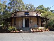
'Belle View' homestead has very high aesthetic, social and historic significance as one of few remaining examples in the metropolitan area of a substantial early farming property that retains high authenticity and integrity and was considered a model farm of its time. As such it is very significant for its rarity and representativeness.
Belle View is still located on a large, urban farm holding whereas most of the surrounding land has long since been subdivided for housing. It sits on an embankment over looking the Helena River flood plain in the western extremity of the Shire of Mundaring whereit borders with the Shire of Swan. The house or homestead is in a very open position and faces north from which it is approached. The rear of the house faces south across the river and some former outbuildings at the edge of the embankment have taken advantage of the fall in land to incorporate a cellar below them. To the north of the house, adjacent to the drive way, is an old weatherboard stable building which is thought to pre-date the house and originally was next to a small mud brick cottage. The stables still contains their original stalls and compartments ans=d have very high authenticity and integrity. The timber is starting to deteriorate at ground level and is in need of stabilising before the damage is irreversible. South of the stables, and closer to the house, is a corrugated iron farm shed, which may be part of, or on the site of, an old barn. The homestead also is in an extremely critical state of disrepair where money and/or the right incentives could easily save it, but where continuing neglect will see it's condition rapidly decline in the coming years. Belle View is a large but simply decorated Federation period, red brick, single storey homestead, having a wide frontage and being only two rooms deep. The front room on the east end projects forward and has a parapet gable end which gives the elevation an asymmetric appearance. The gable has a small rendered panel inscribed "Belle View AD 1887". The projecting room also defines the entry point on the full width of verandah which also surrounds the house. The verandah is in a bad state of repair with the original timber posts, which supported the concave corrugated iron roof sheeting, having been replaced with pine columns. The front north-east corner is unroofed and the deterioration of the verandah across the back has resulted in it's complete removal except for some floor boards.The interior was not inspected however it is believed to be in a deteriorating state. From the outside it appears the layout has formal rooms to the east end of the homestead where two bay windows project onto the verandah. Further assessment is require to determine the extent and significance of the original fabric. Note: In May 1997 the consultants carried out a Heritage Assessment for the Heritage Council of WA following commencement of demolition of the place. A full description of the significance of the place, interiors and the extent of the demolition commenced is noted therein. Demolition was halted and the place entered into the Interim List of the State Register. Mostly the doors, windows, skirtings, architraves and floorboards have been removed whilst the structural fabric remains intact.
In the late 1870's, and prior to his purchase of the area later to be known as 'Belle View', Edward Robinson had pastoral interests in Croyden Station, a sheep run near Roebourne in Western Australia's north-west. 'Belle View' was part of James Stirling's original 4,000 acre Woodbridge Grant, which Henry Brockman purchased in 1883, and subsequently sub-divided. Robinson, uncle of Percy Robinson of Undercliffe (Site 77) bought 750 acres (304ha) and built the single-storey 'Belle View' home. It was constructed of local clay bricks, made on the property and provided a more substantial residence than the mud brick house dating from the 1840's, which was demolished in c. 1973/4. 'Belle View' also featured servants quarters, kitchen, baker's oven and a smoke room for curing meats, attached to the rear of the main building by a wide veranda. The weatherboard and iron roofed stables, located north-west of the house are thought to predate 'Belle View' and include the remnants of a 'blackboy' / grass tree trunk floor. This flooring material, of which few example are thought to remain so close to Perth, was installed to protect horses hooves. The farm which began as a dairy, was considered a model of its era. Edward Robinson was extensively involved in the community, serving as a Justice of the Peace, member of the Greenmount Road Board (1908-1913) and financing the building of the Anglican Church in Clayton Street, Bellevue in memory of his wife. Following her death in 1909 he built a new house called 'Melita' which is of considerable significance and still exists nearby in Clayton Street. After Robinson's death in 1913, the property, minus the northern areas he had already sub-divided and sold, was purchased in 1921, by the pastoral company, Elder Smith. Until his death in 1959, the 'Belle View' property was occupied and managed by Jack Goodchild, Robinson's former coachman and resident stockman for Elder Smith. Nearby Goodchild Oval is named after him. Since writing the original assessment the place has been placed on the Interim List of the State Register to avoid possible demolition of the place (see note above). There have also been talks between the owners of Belle View, local authorities and the Primary School about a possible land swap to relocate the oval adjacent to the school. These negotiations are still on going as at Sept. 1997.
Integrity: High Modifications: Various
Poor
| Ref ID No | Ref Name | Ref Source | Ref Date |
|---|---|---|---|
| Bruce Callow & Assoc.; "Belle View Heritage Assessment". | HCWA | 1997 | |
| I Elliot; ibid. p 221 | |||
| MHHS File; "Belle View". |
This information is provided voluntarily as a public service. The information provided is made available in good faith and is derived from sources believed to be reliable and accurate. However, the information is provided solely on the basis that readers will be responsible for making their own assessment of the matters discussed herein and are advised to verify all relevant representations, statements and information.
ARCHITECURAL & INNOVATIVE The house has architectural merit in siting, orientation and design for climate. This is evident in that the major living rooms have views across to the hills and an encircling verandah shades the walls. The house layout ensures good ventilation. The building is aesthetically competent and accords with similar substantial late 19th Century dwellings. The design of the stables represents a highly organised system of animal husbandry. \ HISTORICAL SIGNIFICANCE \ Historically significant at a local level as the present day suburb of Bellevue was named after Belle View house. The house is also closely associated with the Robinson and Seabrook families. ARCHAEOLOGICAL Excavation of the structure built into the hillside could reveal the function and artefacts which would benefit studies in historical archaeology in W.A. SCARCITY VALUE A fine example of a late 19th Century farm complex. The design and workmanship of the buildings raises the complex above the pedestrian .
A single storey brick building (English Bond) of asymmetrical plan. Awning style verandah on all elevations. The verandah is presently supported by iron posts on east, west and north elevations. Some original wooden posts remain on the south elevation. The roof is galvanised iron. Tuck-pointed brick quoining to corners, front openings and bay windows on east elevation. Stone rubble foundations with bituminous D.P.C. Main entry door has side lights with fanlight above. French doors allow access to the front verandah from a secondary hall. Masonry roof pediment has inscription "Belle View" AD 1887. The main reception areas are evident through a hierarchy of decoration Goinery-plasterwork and mantles) possibly rooms A, B & F. Both the rooms, A & F, had marble fire surrounds (since visit on 15/3/92 these surrounds have been removed). The present bathroom (room H) has fittings which date from 1950s/60s, it is possible this room may have been the original kitchen. The present kitchen (room J) was also renovated at the same time as the bathroom (similar period fittings). Two of the bedrooms (rooms C & E) have fireplaces, only in bedroom C has the mantle survived (wooden). Excavated Structure Stone and brick walls excavated into hillside on south side of house. Unknown function - requires further investigation. Stables These are located c.200m north of the house. Weatherboard construction with corrugated iron roof. The building is divided into several stalls with a passage running behind. Hatches set into the wall allowed access to feeding troughs. The layout of the stables is well considered and displays an attention to planning detail not usually found in this type of building.
Assessment 1992 Construction 1887 Belle View was constructed for Edward Robinson in 1887. Robinson had arrived in Fremantle in Fremantle in 1842 with his widowed mother, (his father died on the voyage out) brother and three sisters. His mother re-married John Seabrook (Sor) and the family moved to Brookton where Edward worked as a shepherd for his step-father. In 1863 he travelled with henry Lefroy as a guide to the Kagoorlie/Boulder area. In 1874 he entered into a partnership with his step brother John Seabrook (Jnr) in the Roebourne area where they established "Croydon." In 1886 he sold his partnership share and purchased 750 acres in the Helena Valley. This land had once been a portion of Stirling's Woodbridge grant. Robinson developed the land as a dairy. The house he built originally had 15 rooms which included servant's quarters, kitchen, baker's oven and a smoke room attached to the rear of the main building by a verandah. (Elliot p.221) The bricks were made om local clay deposits and made on site. There were once extensive outbuildings. The stable\are all that remain. He served on the local Greenmount Road Board 1908-1913. He married a widow, Sophia Bedcock and the couple had no children. After his wife's death in 1909, Robinson donated land to the Anglican Church and built it as a memorial to her memory, the Church of the Good Shepherd in Clayton Street. He then leased the farm and built a new house in Clayton Street, "Melita", where he lived until his death in 1913. On his death the property went to his nephew William E.Robinson, who sold it to Elder Smith & Co. Ltd. During Eider's ownership Jack Goodchild (Robinson's coachman) lived at Belle View until his death in 1959. The house appears to have lain vacant for sometime now.
This information is provided voluntarily as a public service. The information provided is made available in good faith and is derived from sources believed to be reliable and accurate. However, the information is provided solely on the basis that readers will be responsible for making their own assessment of the matters discussed herein and are advised to verify all relevant representations, statements and information.
Hudman Rd Boya
Note: P16787 Mountain Quarry (fmr) was also known as Boya Quarry in an earlier period however this is a separate place to Government Quarries (fmr)
Boya Quarry/ies, Darlington Quarry
Hudman Road Quarry
Mundaring
Metropolitan
Constructed from 1901 to 1950
| Type | Status | Date | Documents |
|---|---|---|---|
| Heritage List | YES | 08 Mar 2016 | |
| State Register | Registered | 07 Sep 2006 | HCWebsite.Listing+ListingDocument, HCWebsite.Listing+ListingDocument |
| Type | Status | Date | Documents |
|---|---|---|---|
| (no listings) |
| Type | Status | Date | Grading/Management | |
|---|---|---|---|---|
| Category | ||||
| Classified by the National Trust | Adopted | 11 Apr 2005 | ||
| Municipal Inventory | Adopted | 22 Apr 1997 | 1 - Exceptional significance | |
All of the structures which have survived on site are in a ruined, but stable condition. The quarry faces are considered to be unstable by the Shire of Mundaring and care is required by abseilors. Government Quarries (fmr) is in fair condition.
| Library Id | Title | Medium | Year Of Publication |
|---|---|---|---|
| 7217 | Images CD No. 25a : assessment images : Statham's Quarry; Govt. Quarries. | C D Rom | 2004 |
| 6999 | Images CD No. 25 : Sacred Heart Church and School, Statham's Quarry, Darlington Quarry, Leithdale. | C D Rom | 2004 |
Landscape
| Epoch | General | Specific |
|---|---|---|
| Original Use | INDUSTRIAL\MANUFACTURING | Other |
| Present Use | PARK\RESERVE | Park\Reserve |
| Style |
|---|
| Other Style |
| Type | General | Specific |
|---|---|---|
| Wall | CONCRETE | Other Concrete |
| General | Specific |
|---|---|
| DEMOGRAPHIC SETTLEMENT & MOBILITY | Resource exploitation & depletion |
| OCCUPATIONS | Mining {incl. mineral processing} |
| TRANSPORT & COMMUNICATIONS | Rail & light rail transport |
This information is provided voluntarily as a public service. The information provided is made available in good faith and is derived from sources believed to be reliable and accurate. However, the information is provided solely on the basis that readers will be responsible for making their own assessment of the matters discussed herein and are advised to verify all relevant representations, statements and information.
government initiative to improve Western Australia’s manufacturing industry and economy prior to and after World War I, and it has the potential to reveal archaeological information about stone crushing technology and quarry operations from the first quarter of the twentieth century; the place is rare as it has retained the physical remains of two separate stone crushing buildings (a pre 1912 crusher and the later 1912 crusher), and the remains of the compressor building which was constructed in several phases; stone from the quarry was used in the construction of the north mole at Fremantle harbour; the place is associated with the development of the quarrying industry, in the Shire of Mundaring, which was first established in the 1870s; and, the scale of the former quarrying operation, in what is now a large bush reserve, has led to strong visual contrasts between the natural bush environment, the individual quarry faces and the remains of the crushing buildings.
Government Quarries (fmr) is a granite and diorite quarry comprising six quarry faces, the remains of two concrete crushing plants (pre 1912 and 1912) and associated concrete engine beds, the remains of a concrete and stone compressor building together with associated concrete engine beds, a short stretch of railway track and the formation for the main spur line which served the quarries. The quarry site is approximately 1 kilometre long and 500 metres deep. The quarry is located to the south of Coulston Road, Boya, at the south-east end of Hudman Road in a residential area. Access to the quarry sites is along the route of the former spur line which served the quarries and the crushing works; there is no evidence of the metal rails. Today, the formation is a dirt track which commences at the south-east end Hudman Road. The track runs along the south-west side of the quarry which is located along a granite and diorite scarp that is aligned approximately east to west. The track formation has been built up with earth fill in some places to create a comparatively level route. There is a slight fall to the east. Due to this infill, the land on the southern side of this track falls away quite steeply in some places. Due to the location of the granite and diorite formations, the rock was quarried on two separate levels. The lower level contains quarries 1, 2 and 3, while quarries 4, 5 and 6 are on the upper level. Quarries 5 and 6 have the largest faces. Natural vegetation is gradually taking over the quarry floors. The remains of the crushing plant (1912, 1927) are restricted to concrete foundations on the northern side of the spur line and associated concrete engine beds. The foundations of the compressor building (1912, 1927) lie in an elevated position to the south of quarries 5 and 6. Only the bottom section of the north wall has survived as it was built into the side of the hill. The remains show smooth faced granite with regularly spaced timber posts. The posts were presumably used to support the roof structure. The 1927 extensions were constructed from concrete form work. Several concrete engine pads remain in situ on the floor. A large proportion of the building has become over-grown with plants. No evidence of the southern section remains.
Assessment 2006 Construction 1912 Alterations/additions: 1912, 1927, 1950 Builder: Public Works Dept The quarries were opened in 1901 by the state’s Public Works Department to provide granite for the construction of the North Mole in Fremantle. State government policy in 1911 saw the development of a number of state owned operations which included the development of the quarry at Boya. Extensions and improvements were made to the plant at the quarries in 1912. These included the construction of a new crushing plant, compressor and power houses, transformer and a new office. Production rose from c.10,000 tons per year between 1912 – 1918 to 15,000 between 1918 – 1921. Increasing demands for rock and blue metal in the 1920s led to upgrades and expansion at the quarries. This work had been completed by 1927. Comparisons between a 1911 plan of the quarries and a 1927 plan show that the quarry faces had grown and additions were made to several of the 1912 buildings. Extensions to the crushing plant saw the 1912 office incorporated into the whole complex, together with further additions on the eastern side. New buildings were added around the quarry faces and the compressor building was extended. New stables and a yard were constructed to the south-west of the crushing complex. During its working period the quarry was operating on a break-even basis and in 1942 it was decided to cease operations. The plant and equipment was sold and the reserve was re-classified in 1957 from ‘Quarries’ to ‘Park and Public Recreation Area’. The site was vested with the Shire of Mundaring in 1976.
This information is provided voluntarily as a public service. The information provided is made available in good faith and is derived from sources believed to be reliable and accurate. However, the information is provided solely on the basis that readers will be responsible for making their own assessment of the matters discussed herein and are advised to verify all relevant representations, statements and information.
The quarry sites of the Shire of Mundaring have varying degrees of significance; however, several have very high social, historic and scientific significance for their role in the development if important, landmark projects in the State including the Fremantle Harbour project, ballast for Stat Railway lines, Kings Park Memorial, Perth GPO, Commonwealth Bank (Forrest Place) and Council House. Over the years, the quarries were important local industries. Over the years, the quarries were important local industries for the region generally and a significant source of employment of convict and immigrant labour.
The physical description of these quarries varies considerably and today several of them no longer exist as they have been filled in or revegetated. The most significant physically and visually are the quarries at Boya and Greenmount, in particular Mountain Quarry at Boya, which has sheer rock faces used recreationally today for rock climbing, abseiling and as examples for geological studies. Boya Quarry: situated 2-3 kms south-east of Greenmount Quarry site are the remnants of two quarries which were important sources of granite.
For almost 100 years, quarries in the area now covered by the Shire of Mundaring were important contributors to the transport and building activiites of Perth and other parts of the State. The most significant of these quarries were at Greenmount, Boya, Snith's Mill (Glen Forrest), Parkerville and mahogany Creek. The quarries supplied crushed granite for road making and rail ballast, rocks for harbour works and granite blocks or slabs for buildings. In other cases gravel (laterite) was mined and used principally for road making. These two quarries were important sources of granite. Eventually both quarries provided blue metal for road base and rail ballast; however, in 1892, when work began on the Fremantle Harbour Scheme, rocks from Boya Quarry were used ro strengthen the limestone north and south moles, The Boya Quarry was south-east of the railway line at the eastern end of what is now Hudman Road. By July 1901, there were about 150 workers living in the area in hessian and iron huts. Their children travelled on the Eastern Railway ti school at Smith's Mill. When the Fremantle harbour works were completed in 1897, the quarry was leased to a Mr Doyle of Boya Quarry and Gravel Comapny Limited. The name 'Boya' was given to the railway siding and is said to be the aboriginal word for 'rock'. Despite Doyle's company going into liquidation in 9110, the Boya Quarry operated intermittently until 1948. In February 1988, the quarry was the setting for several performances for the 9 hour Hindu epic "The Mahabharata", dire
Integrity: Low
| Ref ID No | Ref Name | Ref Source | Ref Date |
|---|---|---|---|
| CT Stannage; "The People of Perth". ppp | |||
| I Molyneaux; "Looking around Perth". pp. 48-49, 56 | |||
| I Elliot; ibid pp.153-154, 163, 168, 174-175, 198-199, 206-207, 247-249, 254. |
This information is provided voluntarily as a public service. The information provided is made available in good faith and is derived from sources believed to be reliable and accurate. However, the information is provided solely on the basis that readers will be responsible for making their own assessment of the matters discussed herein and are advised to verify all relevant representations, statements and information.
2135 Rosedale Rd Chidlow
Chidlow Dam or Chidlow Water Supply
Chidlow's Well Reservoir
Mundaring
Metropolitan
Constructed from 1898, Constructed from 1996
| Type | Status | Date | Documents |
|---|---|---|---|
| Heritage List | YES | 08 Mar 2016 | |
| State Register | Registered | 03 Jun 2005 | HCWebsite.Listing+ListingDocument, HCWebsite.Listing+ListingDocument |
| Type | Status | Date | Documents |
|---|---|---|---|
| (no listings) |
| Type | Status | Date | Grading/Management | |
|---|---|---|---|---|
| Category | ||||
| Municipal Inventory | Adopted | 22 Apr 1997 | 2 -Considerable significance | |
| Classified by the National Trust | Classified | 14 Jun 2004 | ||
| Statewide Railway Heritage Surve | Completed | 01 Mar 1994 | ||
Many of the issues discussed by Gobby in the 1980 Management Plan for the Lake appear to have been implemented and both the Lake, buildings and forest reserve are in good condition.
Landscape
| Epoch | General | Specific |
|---|---|---|
| Present Use | PARK\RESERVE | Park\Reserve |
| Original Use | Transport\Communications | Rail: Water Tower |
| Original Use | GOVERNMENTAL | Reservoir or Dam |
| Style |
|---|
| Other Style |
| Type | General | Specific |
|---|---|---|
| Wall | BRICK | Other Brick |
| Other | TIMBER | Other Timber |
| General | Specific |
|---|---|
| SOCIAL & CIVIC ACTIVITIES | Environmental awareness |
| TRANSPORT & COMMUNICATIONS | Rail & light rail transport |
| SOCIAL & CIVIC ACTIVITIES | Sport, recreation & entertainment |
| OUTSIDE INFLUENCES | Water, power, major t'port routes |
This information is provided voluntarily as a public service. The information provided is made available in good faith and is derived from sources believed to be reliable and accurate. However, the information is provided solely on the basis that readers will be responsible for making their own assessment of the matters discussed herein and are advised to verify all relevant representations, statements and information.
Constructed from 1996, Constructed from 1898
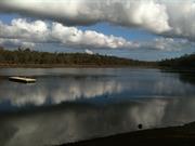
Lake Leschenaultia has very high social and historic significance tot he people, the Shire and the State of Western Australia for it's long established recreational role and it's origins with railway heritage.
townsite and provides a very pleasant, picturesque and "cooling" picnic/recreational facility particularly on hot summer's days away from the coast. Grassed areas with laterite stone retaining walls, picnic tables and shelters are located between the kiosk and lake's edge to the east. Otherwise, the edges of the lake have been left very much in their original naturally landscaped form with large trees coming down close to the waters edge providing extensive shaded areas. The earth dam wall is integrated into a walk trail around the edge of the lake and otherwise, there are few indications of the site's railway heritage. The brick tea room/kiosk building, with ranger's house/office behind, were built in the late 1950s, early 60s. Other than a timber jetty jutting out into the lake, the brick building is one of the few built structures that interrupts the landscape. The kiosk has been designed with little sympathetic acknowledgement of its surroundings and is typical of its period of construction.
Over the period 1897-8, the area now known as Lake Leschenaultia was built as a railway reservoir to supply water for the steam locomotives stopping on the Eastern Railway at Chidlow's Well Station. At a cost of £8,803, the Public Works Department cleared a creek bed north-west of the townsite and constructed an earth embankment to form a 118 million gallon (536,000 cubic metre) reservoir. Two overhead storage tanks at the railway station were supplied by mains from a lakeside steam powered pump, with a full time attendant, who lived in a cottage at the reservoir. As need arose, other railway centres, such as Midland, used tankers to access the water at Chidlow. By 1907, the reservoir's stock of Redfin Perch had become popular with anglers. Initially, 600 pine trees were planted because it was believed they improved the water quality. However, clearing in the catchment area increased the water's salinity and by 1930 (or earlier), it was considered unsuitable for railway use. The Greenmount Road Board acquired the lake in c. 1933, and except for the period 1941-1947, when the reservoir was resumed for possible wartime use, began to develop it as a picnic and resort area. The name "Lake Leschenaultia" was one used locally because the colour of the lake was said to resemble the blue Lechenaultia flower. Throughout the 1950's, the entrance tickets and references in the Mundaring Road Board minutes named the lake as 'Lake Leschenault'. The correct spelling, with "ia" on the end, was restored in 1960. From the 1950's, a small kiosk operated from the lake and sold sweets, cool drinks and local orchard produce. Changes over the last 40 years include the building of a caravan park (now removed), tea room extensions to the kiosk, and a ranger's house. The lake continues to operate as a recreation; area for the local shire and the Perth region.
| Ref ID No | Ref Name | Ref Source | Ref Date |
|---|---|---|---|
| I Elliot; ibid. pp58, 59, 60, 71, 73. | |||
| MHHS File; "Chidlow". |
| Owner | Category |
|---|---|
| Shire of Mundaring | Local Gov't |
This information is provided voluntarily as a public service. The information provided is made available in good faith and is derived from sources believed to be reliable and accurate. However, the information is provided solely on the basis that readers will be responsible for making their own assessment of the matters discussed herein and are advised to verify all relevant representations, statements and information.
Lake Leschenaultia, which comprises a dam, toilet facilities, restaurant, picnic and camping areas and associated natural bushland, has cultural heritage significance for the following reasons: • the place is the only nineteenth century railway reservoir in Western Australia which has been developed into a recreational area which offers a range of activities and attracts large numbers of visitors from overseas and inter and intra state; • the place was constructed in c.1898 as part of the infrastructure of the Eastern Railway line and supplied water for the trains using this line for nearly fifty years. The Eastern Railway line played an important role in the development of the Eastern Goldfields; • the place was the largest reservoir constructed on the Eastern Railway line; • the presence of a lake set in forest surroundings, has led to the place becoming a popular recreational venue since 1949; and, • the place played an important role in the lives of thousands of local children who learnt to swim in the Lake.
Lake Leschenaultia comprises a dam, toilet facilities, restaurant, picnic and camping areas and associated natural bushland. Lake Leschenaultia lies slightly to the north of the village of Chidlow which is approximately 50 km east of Perth. The Lake is surrounded by regenerating forest and partially cleared land. Four creeks feed into the lake with a fifth creek acting as a feeder for one of the primary creeks. The topography around the Lake itself is comparatively flat, with small valleys and ridges associated with the creek systems in the forest reserve. The main vehicular entry is situated off Rosedale Road on the northern side of the Lake. Pedestrian access is possible at various points along the eastern forest reserve. The main entrance is marked by a small timber framed and clad building (with a zincalum roof), where the Lake entry fee is collected. A bitumen road, with concrete curbs, leads to either the eastern or western sides of the Lake. A gravel road encircles the entire Lake and is used only by the park ranger (gates across this road block public access). This track also serves as the pedestrian nature trail. The main picnic area is located on the eastern side of the Lake together with a camping area. A secondary picnic area is located on the western side. Five artificial beaches have been created on the foreshore of the Lake, the largest in front of the main picnic area and four smaller beaches on the western side of the Lake. The dam wall lies directly opposite the main entrance. It rises approximately l0 metres above ground level. The northern face is a steep incline covered mostly with exotic grasses while jarrah trees have become established on the lower section of the slope. The flat area immediately to the north of the wall is a grassed and equipped with a concrete bar be que and picnic table. A poplar tree (Populus nivra var. italica), this was one of the only exotic tree species noted at the Lake, has been planted at the south eastern side of this grassed area. The southern face of the dam is sealed with widely spaced laterite rocks over which has been laid a facing of cement render. The top of the dam wall is approximately 2.5 metres wide with a low stone wall (laid with roughly dressed laterite stones randomly laid) on the northern side. The top of dam, which is a gravel track, forms part of the nature walk. The overflow for the dam is located at the western end of the dam wall. It is spanned with a steel and timber decked bridge. A timber jetty, which is sited approximately mid-way along the wall, extends out into the lake for about 40 metres. Bitumen roads provide access to picnic areas which are located on the north-eastern and north-western sides of the Lake, with that on the north-eastern side being the main area. This area features 'Stoker's Cafe', which was built in 1962 and originally functioned as tea rooms and care taker's residence. The area in front of the Cafe is covered with grass and shaded with widely spaced jarrah (Eucalyptus marginata) and marri (Eucalyptus calophylla) trees. Below the picnic area is a white sandy beach with mature jarrah trees (Eucalyptus marginata) near the lake shore. A shed, where Canadian canoes can be hired, is located at the south eastern end of this beach.
Assessment 2004 Construction c.1898 Alterations/Additions: 1961, 1989, 1996 Lake Leschenaultia was constructed by the Department of Working Railways and Tramways in c. 1898 to suppl y water for trains using the Eastern Railway. The Eastern Railway was completed by the Western Australian government in 1896 and stretched between Guildford and Coolgardie. The discovery of gold in the eastern districts during the 1880s, while beneficial for the state, had the serious drawback of being in fairly arid zone so that adequate water supplies soon became a problem. This problem was essentially solved with the construction of the Goldfields Water Supply Scheme in l 903. However, this scheme was unable to supply the demand made by the steam engines which ran on the Eastern Railway. To solve this problem , a number of reservoirs were constructed at various points along the line. Plans for a reservoir at Chidlow were prepared in l897. The estimated carrying capacity of this dam was estimated at being 118,000,000 gallons; making it the largest reservoir constructed by the Railways Department. As the records make no further reference to the reservoir al Chidlow it has been difficult to determine an exact construction date. However, by 1899, in the annual report to Parliament, the reservoir is listed by the Railways Department as holding 117,000,000 gallons and costi ng £8,803 to construct. Water was fed from the dam to the Chidlow railway platform via a water pipe. The land surrounding the dam was eventually gazetted for water supply purposes in 1901. Salinity problems with the water led to the construction of drainage ditches and an extensive planting programme during the first quarter of the twentieth century. However, over time, the problem appears to have increased and the reservoir ceased to be used as a mai n water supply source by the Department. Eventually, by 1947, the Railways Department agreed to lease the site to the Mundaring Roads Board for recreational purposes. A portion of the reserve was leased to the Board for 21 years and in 1949 the dam was officially named Lake Leschenaultia . The area immediately became popular with local residents and the Board began to supply facilities. Toilets were initially provided. The Shire of Mundaring secured a grant in 1961 to construct better facilities at the site and this resulted i n the construction of a single building which operated as tea rooms with care taker facilities at the rear. Over the years further facilities have been added to the area including trout fishing during the 1970s. Boating continues to be a popular feature on the Lake, although fishing is no longer available. The regenerating bushland has also led to the development of walk and bike trails and the area has become a popular bird watching venue. In 1997, Lake Leschenaultia was placed on the Shire of Mundaring's Municipal Inventory. In 2004, the site continues to be used for publi c recreation purposes.
This information is provided voluntarily as a public service. The information provided is made available in good faith and is derived from sources believed to be reliable and accurate. However, the information is provided solely on the basis that readers will be responsible for making their own assessment of the matters discussed herein and are advised to verify all relevant representations, statements and information.
Darlington Rd Darlington
Just off Darlington Road, between Dalry and Coulson Roads.
Saw Estate
Mundaring
Metropolitan
Constructed from 1890 to 1940
| Type | Status | Date | Documents |
|---|---|---|---|
| Heritage List | YES | 08 Mar 2016 | |
| State Register | Registered | 22 Nov 2005 | HCWebsite.Listing+ListingDocument, HCWebsite.Listing+ListingDocument |
| Type | Status | Date | Documents |
|---|---|---|---|
| (no listings) |
| Type | Status | Date | Grading/Management | |
|---|---|---|---|---|
| Category | ||||
| Classified by the National Trust | Classified | 24 Jul 1980 | ||
| Municipal Inventory | Adopted | |||
Holmesdale is in fair condition with minor cracking to some of the walls and a rising damp problem in one of the interior walls.
| Library Id | Title | Medium | Year Of Publication |
|---|---|---|---|
| 7026 | Images CD No. 30 : assessment images : Blackboy Hill Site, Holmesdale, Mt Helena Tavern, Undercliffe. | C D Rom | 2004 |
Individual Building or Group
| Epoch | General | Specific |
|---|---|---|
| Present Use | RESIDENTIAL | Single storey residence |
| Original Use | RESIDENTIAL | Single storey residence |
| Style |
|---|
| Federation Queen Anne |
| Type | General | Specific |
|---|---|---|
| Other | TIMBER | Weatherboard |
| Roof | METAL | Corrugated Iron |
| Wall | STONE | Granite |
| General | Specific |
|---|---|
| OCCUPATIONS | Rural industry & market gardening |
| DEMOGRAPHIC SETTLEMENT & MOBILITY | Land allocation & subdivision |
| PEOPLE | Early settlers |
This information is provided voluntarily as a public service. The information provided is made available in good faith and is derived from sources believed to be reliable and accurate. However, the information is provided solely on the basis that readers will be responsible for making their own assessment of the matters discussed herein and are advised to verify all relevant representations, statements and information.
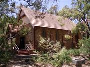
This house is historically important as the first substantial dwelling in the Darlington area and for its association with Waylen and Amherst and the early years of the wine industry. It is well sited with attractive, though neglected, grounds. Architecturally it is of interest as an imposing country residence of the 1890's, retaining typical details of that era e.g. verandah detailing, French doors and louvre shutters, all of which appear to be original.
The property on which this house stands was taken up by Dr A.Waylen in 1884 to be developed as a vineyard as he found Garden Hill at Guildford too small. In 1888 Hon. J.G.A. Amherst, private secretary to Governor Broome who remained in the colony after Broome's departure, joined him in partnership and built the present house described in the West Australian in 1890 as "a neat little chalet of blue granite". Amherst lived on the property and managed it until his death in 1900. A section was added to the back of the house in the 1940's but otherwise it has been little altered.
Assessment 1980 Construction c.1890
This information is provided voluntarily as a public service. The information provided is made available in good faith and is derived from sources believed to be reliable and accurate. However, the information is provided solely on the basis that readers will be responsible for making their own assessment of the matters discussed herein and are advised to verify all relevant representations, statements and information.
Constructed from 1890
Holmesdale has a very high social and historic significance for it's association with Amherst, who was a very important State and local figure, especially in the development of the Darlington community. To a lesser extent, it is also important for it's associations with saw who later donated the adjacent land to the University. The house has a strong social significance for the people of Darlington and has aesthetic significance as an excellent example of early stone houses which characterise the 'village'. This significance is strengthened by it's high authenticity and integrity which give the house added qualities of representativeness and rarity.
Holmesdale is located on a large residential lot just off the low (west) side of Darlington Road, Darlington. Whilst the original land holding was subdivided into smaller lots, the residence still has the feeling of spacious grounds. The house would have originally been approached from the low side, or south-west, but the point of arrival is now from the east off Darlington Road. However the outlook to the west remains much as it would have although the trees obscure some of the view to the west and the city beyond. The house is built of a local granite and dolerite stone laid in rough coursing but with a joint struck in the cement mortar to give an impression of more regular joints. The 'M' roof is of corrugated iron with a wide veranda attached below the eaves on the south-west and north-east sides. The natural ground level drops away sufficiently on the west to facilitate the construction of a cellar below the house and is accessed via a stair from the south-west, "front" veranda. The cellar is of stone construction, however additional basement area under the house has been infilled with weather-boards. An entry portico on the south-east is a later addition but is in keeping with the timber detailing of the veranda. However, a slight variance in the proportions of the portico, compared with the original elements of the house, serves to distinguish between the old and the more recent fabric. Adjacent to the entry, and set into the hill just below Darlington Road, is a stone garage with red brick quoins which contrast rather unsympathetically with the other stonework of the house. Holmesdale has been built in two main stages which are evident from an inspection of the fabric internally and externally in the variation in stone. The original 'Amherst' residence comprises the rooms to the front (south-west) of the house. During the time of the Saw's, major alterations occurred on the rear (north-east), in the form of added rooms. These included an internal kitchen and a veranda across the back which have been further altered and enclosed over the years. The original rooms are simply finished and not highly decorative. They still have complete authenticity and integrity with their timber floors, plastered walls and 'mini-orb' corrugated iron ceilings. The newer section of the house to the rear is identified by a change in floor level (one step up) and plasterboard ceilings. The veranda at the rear has been enclosed to provide additional informal living space and bedrooms.
In cl890 (or late 1880's), 'Holmesdale' was built for the Hon. Josceline Amherst, who came to Western Australia in 1885, as Governor Broome's private secretary and Clerk of the Executive Council. Amherst was drawn to the hills after Surgeon Alfred Waylen's March 1886 offer of shares in the Darlington Vineyard he'd established in 1884. Before building Holmesdale, Amherst may have lived in the vineyard's existing 3 roomed cottage. Holmesdale was built on part of Lot 71, an Eastern Railway allotment purchased by Waylen in October 1886. The "blue" granite for the house was said to have been laid by the same Italian stonemasons (Source: MHHS) supposed to be responsible for the Darlington Vineyard Cellars, now part of the Darlington Hall (Site 139). Amherst is said to have been responsible for some of the carpentry work in both his house and the cellars. Holmesdale was named after his family's estate in Kent, England. Amherst took an active interest in the vine and fruit growing associations in the hills. He also encouraged his gardener, Mauritian Francois Arekion in his tea planting experiments. Arekion came to Holmesdale in 1889, when frost and financial difficulties forced him to abandon his Chittawarra Brook nursery at Smith's Mill. Amherst headed the committee which was responsible for building the Smith's Mill Agricultural Hall in 1897. The name "Amherst" was officially given to the Government townsite at Smith's Mill locality for a brief period in 1902, before it was reverted to the better known local name. Smith's Mill became Glen Forrest in October 1915. Amherst took an active role in local government, being a member of Swan Road Board and, in 1898, the innaugural Chairman of Darling Range Road Board. After Amherst died in February 1900, Holmesdale was purchased by former publican of the Mundaring Hotel, John C Chipper, grandson of the John Chipper who is associated with Chipper's Leap. After Chipper's death in 1906, the property was purchased by William Allnut Saw, of the Department of Lands and Surveys. Between 1924 and 1934, a golf course operated on the western section of Holmesdale, then known as the Saw Estate. After the golf course was no longer used, the Saw family donated the land tot he University of Western Australia which sub-divided the land for housing in the early 1970's. Except for a few changes to the rear of the house c.1950, few alterations to Holmesdale have been made. An assessment and report by the National Trust was completed in 1980.
Integrity: Very high, still used as a private residence. Modifications: Additions and veranda enclosures to rear (east)
good-some rising damp affecting stonework; eaves and quoins damaged in 1969 Meckering earthquake
| Ref ID No | Ref Name | Ref Source | Ref Date |
|---|---|---|---|
| MHHS File; "Darlington". | |||
| I Elliot; ibid pp. 162, 180, 194-197, 277 |
This information is provided voluntarily as a public service. The information provided is made available in good faith and is derived from sources believed to be reliable and accurate. However, the information is provided solely on the basis that readers will be responsible for making their own assessment of the matters discussed herein and are advised to verify all relevant representations, statements and information.
Cnr Hillsden & Darlington Rd Darlington
Mundaring
Metropolitan
Constructed from 1925 to 2001
| Type | Status | Date | Documents |
|---|---|---|---|
| Heritage List | YES | 08 Mar 2016 | |
| State Register | Registered | 03 Jun 2005 | HCWebsite.Listing+ListingDocument, HCWebsite.Listing+ListingDocument |
| Type | Status | Date | Documents |
|---|---|---|---|
| (no listings) |
| Type | Status | Date | Grading/Management | |
|---|---|---|---|---|
| Category | ||||
| Municipal Inventory | Adopted | 22 Apr 1997 | 2 -Considerable significance | |
| Anglican Church Inventory | YES | 31 Jul 1996 | ||
Superficially, St Cuthbert’s Anglican Church, Darlington is in good condition. However, there appears to be an underlying structural problem which has caused cracking to the walls above the windows and in the western façade where the brick and stonework meet.
| Name | Type | Year From | Year To |
|---|---|---|---|
| George Herbert Parry | Architect | - | - |
| Library Id | Title | Medium | Year Of Publication |
|---|---|---|---|
| 10263 | St Cuthbert's Church, Darlington | Heritage Study {Cons'n Plan} | 2013 |
Individual Building or Group
| Epoch | General | Specific |
|---|---|---|
| Present Use | RELIGIOUS | Church, Cathedral or Chapel |
| Original Use | RELIGIOUS | Church, Cathedral or Chapel |
| Style |
|---|
| Inter-War Gothic |
| Type | General | Specific |
|---|---|---|
| Roof | TILE | Other Tile |
| Wall | BRICK | Other Brick |
| Wall | STONE | Local Stone |
| General | Specific |
|---|---|
| DEMOGRAPHIC SETTLEMENT & MOBILITY | Land allocation & subdivision |
| SOCIAL & CIVIC ACTIVITIES | Religion |
| DEMOGRAPHIC SETTLEMENT & MOBILITY | Settlements |
This information is provided voluntarily as a public service. The information provided is made available in good faith and is derived from sources believed to be reliable and accurate. However, the information is provided solely on the basis that readers will be responsible for making their own assessment of the matters discussed herein and are advised to verify all relevant representations, statements and information.
Constructed from 1924
St Cuthbert's Church, Darlington has very high aesthetic and social significance for the Darlington community in its contribution to the sense of place that residents feel for the place and the building's landmark value in the 'village' precinct.
St Cuthbert's Church in Darlington is one of the key, landmark buildings defining the village precinct. The shady wooded site, with low stone boundary walls, lych gate and the stone church itself, makes a significant contribution to the 'village' ambience that characteristically identifies Darlington and which engenders the affection locals have for the place. The tall well proportioned walls of the church are of local granite and earthy tones (not the blue/grey type) with darker stone on the lower half of the wall and lighter stone on the upper section. the stonework is punctuated with red brick quoin, buttresses, steps and surrounds to pointed Gothis arched windows and doors, The long side walls are broken into four structural bays separated by brick buttresses reaching only two thirds of the way up the wall and which have rendered cappings. The southern stone gable end wall of the church has a projecting, half octagon shaped sanctuary of matching stone and brick quoins capped with tiles roof below the eaves of the main roof. The roof is of modestly steep pitch 'Marseilles' pattern terra-cotta tiles. The low front boundary wall and brick lych gate compliment the church building and defines the site; however the stone wall, which has a rendered capping, is unfortunately of a greyer colour than the church walls. A recently constructed outbuilding at the rear of the church isof framed construction and sits uncomfortably alongside the Church building although it was located and modified with council approval.
Before the church was built, Darlington people worshipped at Smith's Mill (now Glen Forrest), or private houses including Leithdale. In early 1924, Lot 24 of the Hillsden Estate was donated for a church by Mrs JF Stone and her daughters. The foundation stone for St Cuthbert's was laid on Sunday 13th September 1924, by Archbishop Charles Riley. The architect was George Herbert Parry and the builder Mr E Bishop. A glass jar with a description of the event was placed in the foundation stone's cavity. The building which cost about 900 pounds was consecrated on March 1st 1925. The original 1924 church bell was stolen and when St George's Church Greenmount closed, a second bell, currently the one in use, was moved to rest in a steel frame at St Cuthbert's. in 1955, a stone wall, donated by Grace Scott-Clark was erected on the Darlington Road frontage. In 1985, a memorial garden was designed and built by Bert Holmes. In 1993, wooden swing gates, replacing the original ones and dedicated to the memory of Squadron Leader Arthur Richard payne (1913-1987) were placed on the lynch gate/
Integrity: Very High Modifications: Lychgate and fence added.
| Name | Type | Year From | Year To |
|---|---|---|---|
| George Herbert Parry, | Architect | 1924 | - |
| Ref ID No | Ref Name | Ref Source | Ref Date |
|---|---|---|---|
| I Elliot; ibid. ch. 11 | |||
| MHHS file "Religious History, Churches". | |||
| Letter from the Anglican Church of Australia, Diocese of Perth | 10^ June 1996, | ||
| P Pearce; "compiled historical evidence from Parish records". |
| Owner | Category |
|---|---|
| The Diocesan Trustees- Anglican Church of WA | Church Property |
This information is provided voluntarily as a public service. The information provided is made available in good faith and is derived from sources believed to be reliable and accurate. However, the information is provided solely on the basis that readers will be responsible for making their own assessment of the matters discussed herein and are advised to verify all relevant representations, statements and information.
St Cuthbert’s Church Darlington has cultural heritage significance for the following reasons: It is significant as a small community church that has ministered to the social and spiritual needs of the Darlington and surrounding community since 1929. It contains important work by the stained-glass Studio of Gowers and Brown and has a good representative example of their technologically innovative dalle de verre work. It adds to the community’s sense of place through its continued support of Christian spirituality, amenity and through its aesthetic contribution to the built environment. It is a simple and well-crafted rustic style building designed by architect George Herbert Parry that merges well with its setting forming a picturesque landmark on the Darlington Road. The lychgate and boundary wall are an important part of the setting of the church and its landmark qualities.
Cuthbert’s Church is located on the corner of Darlington and Hillsden Roads in Darlington on a triangular plot of land that ascends towards the north-east. The property is lot 24 on Hillsden Road (plan 3361) and covers 4274 square metres of well-treed gravel and loamy soil. The picturesque property comprises a stone and clay tile church building linked with a covered walkway to a large brick and clay tile parish hall and facilities building. The block slopes approximately 12 degrees north-east along Hillsden Road and is covered with wild grass, bushland (which includes introduced species) and substantial native trees. Cleared areas are provided for parking and a small patch of grass near the parish hall. A stone wall with a brick and tile roofed lychgate runs for approximately 65 metres along the Darlington Road Boundary. St Cuthbert’s Church has been built in an Inter-War Gothic style with arts and crafts influences in the use of vernacular materials and detailing such as the use of local stone, open eaves with no fascia and half-timbered style battened gable end. The front porch is a recent (2001) steel frame construction with a modern terra cotta Marseilles pattern tiled roof to match the existing church. The porch is linked to a covered walkway of the same construction. The interior features a timber paneled ceiling, seven stained glass windows in the nave section and two concrete and glass windows in the sanctuary, the floor is timber boards. A mosaic depicting the last supper hangs on the eastern sanctuary wall. Recent conservation works to the church include new steps leading on the southern side, water from the downpipes on the southern side is now being discharged away from the building, repairs to cracks in the interior and repainting the interior walls Reverse cycle air-conditioning units have been installed, this comprises two interior units on the interior side of the church’s western wall and two exterior units on the western side of the covered way to facilities buildings. On the northern side of the building, the problem of water discharging directly from the downpipes and onto the ground has not been addressed, nor has the bitumen, which directly abuts the walls, been cut back as recommended in the 2013 Conservation Plan. The crack which have been repaired in the recent works is re-appearing.
Assessment 2022 Construction 1925 Architect/designer: Herbert Parry Builder: Eric Bishop Alterations/additions: Lychgate 1955; Porch and Parish buildings 2001 St Cuthbert’s Church, Darlington is situated in the Perth suburb of Darlington, which is approximately 25 kms to the east of the Perth Central Business District. The place comprises a 1925 stone church together with a stone wall along the north-west boundary of the property which is punctuated midway along its length by a lychgate. A brick, facilities building is located to the north of the church. When settlers began arriving in numbers in the Darlington area in 1883 this area had been the home of the Whadjuk Noongar people for over 50,000 years. Whadjuk people of the Swan and Canning River systems were divided into individual family-based groups that had recognised traditional territory and hunting rights in a complex land ownership system. Imposed European style land systems did not recognise these and abolished that traditional ownership destroying the Noongar’s intimate connections with land/country, essential for their livelihood and health. At the time of the founding of the Swan River Settlement in 1829, the Aboriginal group that occupied the land around Darlington were the Beeloo who had winter camps in the Kalamunda and Mundaring districts. The area around Mundaring Weir was of special significance as the swamp pools (Mundjallena) now inundated by the Weir, were the home of a powerful Waugal associated with destructive weather. As Hughes- Hallet (2010) records there are several significant Aboriginal sites in the vicinity of Darlington and the Helena Valley including places associated with the Sacred and initiation 4 traditions. Noongars used the Helena River as a travelling route and had established places for rest along its length. (p. 69). The suburb was first settled by Europeans in 1883, when Dr Alfred Waylen purchased 150 acres on which he established a vineyard that he named ‘Darlington’. Following the construction of Stage 1 of the Eastern Railway line in 1884, the potential of the area for settlement was realised and land around the railway line was sub-divided and released for sale. The developing suburb took its name from Waylen’s vineyard. The Darlington area rapidly grew over the course of the late nineteenth and early twentieth centuries as a picturesque place in the hills and a popular alternative for Perth businesspeople who favoured a bush setting for their homes, commuting to Perth each day on the train. The place also became a popular holiday destination leading to the establishment of holiday homes and boarding houses. Subdivision of larger parcels of land continued over the early twentieth century including that owned by John F Stone, a government worker who resided in Fremantle. Stone died in 1909 and left the land to his wife Amelia who divided the land and sold it off, donating a block to the Diocesan Trustees of the Church of England in Western Australia. It was not until 13 September 1924 that a foundation stone for an Anglican Church, laid by the Archbishop of Perth Charles Riley, was set. This event was well attended by residents and visitors from nearby Greenmount, Bellevue, Midland Junction and the Swan Valley. Don Newman <donn@iinet.net.au> The church was designed by prominent Perth architect, George Herbert Parry and was built of stone and brick by contractor Eric Bishop. It was named after St. Cuthbert’s Church, Darlington in County Durham apparently on the instigation of local resident A O Neville, one-time Chief Protector of Aborigines and a champion and executor of infamous government policies on the removal of Aboriginal children from their families who are now known as the Stolen Generation. The church was completed and consecrated by the Archbishop of Perth on Sunday 1 March 1925. Various furnishings and memorials have been added to the church over the years including the donation of a bell and tower by Helen Lillian Gaze in 1934, in memory of her husband Frederick Owen Gaze who had been killed in World War One. Her son William Frederick Owen Gaze had a mosaic reredos installed (1955-56) on the eastern nave wall depicting Leonard da Vinci’s Last Supper and dedicated to the memory of Ruth Loxton Bennet. In 1955, Mrs Grace Scott-Clark, the widow of the Rev. Scott-Clark, donated funds to construct a stone wall along the Darlington Road boundary and a lych gate, in memory of her husband. The original timber gates were damaged in 1977 through vandalism and were removed for safe-keeping. Vestry member, Brett Payne requested permission to replace the old gates with a set of new ones dedicated to the memory of his father Arthur Richard Payne. The establishment of the Memorial Garden, an idea first raised in June 1982, was developed by parishioners Bill Jones and Mike Tooby (a landscape architect). It was completed around 1985. A significant feature of the church are stained glass windows by the well-known and distinguished stained glass Studio of Gowers and Brown. This includes a pair of concrete and glass windows installed in the sanctuary. Funds from the sale of the nearby Church of the Good Shepherd in Bellevue (c2000) enabled the construction of a Facilities building on the St Cuthbert’s site that included a meeting hall, Sunday school area, toilets and an office for the Rector. The new building, together with a porch that was added onto the church and a covered walkway extending from the porch to the new building was opened in 2001. In 2012 an additional set of rooms were added onto the western side of the Facilities building
This information is provided voluntarily as a public service. The information provided is made available in good faith and is derived from sources believed to be reliable and accurate. However, the information is provided solely on the basis that readers will be responsible for making their own assessment of the matters discussed herein and are advised to verify all relevant representations, statements and information.
5-7 Lukin Av Darlington
Leithdale Hostel
Mundaring
Metropolitan
Constructed from 1983, Constructed from 1898
| Type | Status | Date | Documents |
|---|---|---|---|
| Heritage List | YES | 08 Mar 2016 | |
| State Register | Registered | 17 Feb 2006 | HCWebsite.Listing+ListingDocument, HCWebsite.Listing+ListingDocument |
| Type | Status | Date | Documents |
|---|---|---|---|
| (no listings) |
| Type | Status | Date | Grading/Management | |
|---|---|---|---|---|
| Category | ||||
| Municipal Inventory | Adopted | 22 Apr 1997 | 1 - Exceptional significance | |
| Library Id | Title | Medium | Year Of Publication |
|---|---|---|---|
| 6999 | Images CD No. 25 : Sacred Heart Church and School, Statham's Quarry, Darlington Quarry, Leithdale. | C D Rom | 2004 |
Individual Building or Group
| Epoch | General | Specific |
|---|---|---|
| Present Use | RESIDENTIAL | Single storey residence |
| Original Use | RESIDENTIAL | Single storey residence |
| Style |
|---|
| Federation Filigree |
| Federation Queen Anne |
| Type | General | Specific |
|---|---|---|
| Roof | METAL | Corrugated Iron |
| Wall | STONE | Granite |
| General | Specific |
|---|---|
| DEMOGRAPHIC SETTLEMENT & MOBILITY | Land allocation & subdivision |
| PEOPLE | Early settlers |
| OCCUPATIONS | Rural industry & market gardening |
| PEOPLE | Famous & infamous people |
This information is provided voluntarily as a public service. The information provided is made available in good faith and is derived from sources believed to be reliable and accurate. However, the information is provided solely on the basis that readers will be responsible for making their own assessment of the matters discussed herein and are advised to verify all relevant representations, statements and information.
Constructed from 1894
'Leithdale' has very high aesthetic, social and historic significance for the Shire of Mundaring and the people of Western Australia. Its aesthetic significance is contained in the authenticity of its style materials and setting. The social and historic significance is found in the association 'Leithdale' had with Allpike, Skinner and D.H. Lawrence and the example the house provides of an early hills residence/lifestyle, and various other social uses benefiting the community such as school, church and convalescent home.
Leithdale sits high on the steep hillside of the escarpment, overlooking Helena Valley, Darlington, and looking west towards the city and the coastal plain. The site has been largely obscured by trees and vegetation until recently when pruning and new landscaping has re-opened vistas to and from the property. Unfortunately, the busy vehicular use of Lukin Avenue, which curves very closely around the southern side of the house, intrudes on the original ambience of the site and the house. The surrounding grounds and gardens have been quite extensive at different times in the life of the house and remnants of stone retaining walls, ponds and other landscape elements variously remain. A fenced swimming pool, off to one side at the front of the house, was an intrusive element in the front gardens but has now been removed. The house is high out of the natural ground level at the front (west) and side (south) requiring large flights of steps to give access up to the front entry and verandas that surround the house. The north side and rear are at ground level or cutting into the hill. Out from the rear veranda there is a small octagonal brick and stone outbuilding thought to have been the dairy or 'cool' room for storing milk etc. The wide timber boarded verandas have a shallow concave curved roof, supported on timber posts with cast iron Iacework to the beams and brackets and timber cross pattern balustrades at the front. The house is basically symmetrical in plan but the external appearance has achieved a typical asymmetrical element of the Federation period with the projection of a bay window to the large living room on the north side of the entry. The half octagon bay window forces the veranda to radiate around the projecting bay, breaking up what would otherwise be a straight facade and, at the same time, giving definition to the entry. Generally the external walls are of local granite laid in random courses with brick quoins at corners and surrounds to openings with the exception of the bay window that is rendered and painted white. This gives further expression to the asymmetry and definition of the entry and appears to be an original feature as evidenced by the earliest photos in the collection of the current owners. There is a veranda enclosure of weatherboard and glass on the south side creating a conservatory effect which appears to be a fairly old, possibly original, feature. A similar enclosure on the north side appears to be a recent addition to provide attached laundry facilities (off the kitchen and scullery) which originally would have been in an external wash-house. The entry into the house is through a large single timber panelled door with stained glass side and highlights and into the end of a wide, central hall running the length of the house. The entry end of the hall is defined by projecting piers with moulded corbels supporting an arch with label moulds and voussoir at the top. The piers either side have moulded capitals giving a belted column effect and have been painted to simulate marble (this appears to be original). The ceilings to the hall are tall and have deep cornices and large centre roses which are new and, one assumes, replace similar originals. Some of the cornices are cracked and coming away and several sections of the lathe and plaster ceilings have been badly water damaged by overflows from the central box gutter in the 'M' shaped roof above. These ceilings require urgent repairs or stabilization before they are beyond saving. (Conservation techniques are available that should allow the ceilings to be restored and not necessarily replaced.) Rooms open off either side of the hallway. Although some of the rooms ar quite small by comparison to others in the house, all are similarly detailed with high ceilings, cornices,ceiling roses ad fireplaces with timber surrounds to virtually every room. The front living room on the north, with bay window, has a marble fireplace surround with detailing similar to the archway supports in the hall. The separate windows of the bay have raised sills whereas the other front room, and several others on the south side, have tall 'step through' double hung windows or French Doors opening onto, and protected by , the wide verandahs. Further down the hall a large kitchen and scullery opens off to the north. The hall terminates with a second, plainly detailed arch at what has been described as a 'ballroom' and is now used as a very large, informal, family living room. Externally the stone work to the walls at the rear of the house indicate that it has been rebuilt or was a later addition. During it's convalescent home period it is thought the ballroom, which had fallen into disrepair, was subdivided into smaller spaces. Subsequently, this section of the house underwent alterations in the early 1980's to provide additional bedroom accommodation in the roof space. This approach was taken o avoid imposing a second storey into the original single storey fabric and external appearance of the house. However, it has been at the expense of creating an intrusion of a stair at the entry into the ballroom from the hall and a very low section of ceiling and vertical bulkhead that extends across about one third of the room. Overall, the extensive 1980 alterations and restorations have been carried out sensitively, using sympathetic and sometimes recycled materials from other sources. However, there is generally little indication or definition between original and introduced fabric to guide future conservation work and this may lead to confusion with interpretation.
In 1894, John Allpike,manager of Padbury, Loton & Company's stores in Terrace Road, Guildford, built 'Leithdale' on part on part of the 19 acres of Lot 32. The house, said to cover 66 squares, and similar in design to 'Holmesdale', was reputed to have been built from stone quarried at nearby Smith's Mill. There were separate cellars, a manager's house known originally as 'Leithdale Cottage' and more recently, as 'Flagstaff'. In addition, the property had at one time contained an extensive vineyard (Established c.1890) and orchard, tennis court and a guest house, thought to have been built c.1919. as with all the area's original homes, periodic subdivisions have substantially reduced the size of the property. As well as being a family home, 'Leithdale' has served the communiyt in many ways. Until it moved to it's present site in Glen Road, Darlington Primary School's 10 students were taught at 'Leithdale' from May 1912 to October 1913. At sometime after 1907, when Vickery K Jones became the owner and before there was a dedicated building, monthly church services were held at Leithdale. During the period 1922-1928, Mollie Skinner and Ellen Beakbane opened Leithdale as a guest house. In May 1922, on thier short visit to Australia DH Lawrence and his wife Freda stayed at Leithdale for two weeks. It is thought they stayed in the 1919 guest house (now in Brook Road) rather than the main residence. In 1924 DH Lawrence published hie re-worked version of Mollie Skinner's manuscript "The Boy in the Bush" under their joint names. In common with other large homes in the hills, such as Ballindown, Leithdale operated as a convalescent home. Between 1932 and 1955, this was operated by Matron Myra Wills. During the 1940's, the French Club from the University of Western Australia held weekends there. After Mollie Skinner died in 1955, the property was owned until 1980 by Dr and Mrs Chester. In 1980, extensive renovation and restoration, under the supervision of national Trust architect John Pigeon, were carried out by the Templeman Family. In 1996, the property changed hands and the present owners have removed the swimming pool.
Integrity: Very high - with most of the original fabric intact; some confusion may exist with introduced fabric. Modifications: Rear of house modified to provide additional accommodation in the roof space.
Very good, but requiring constant upkeep
| Name | Type | Year From | Year To |
|---|---|---|---|
| John Pigeon (National Trust Architect) | Architect | 1980 | - |
| Ref ID No | Ref Name | Ref Source | Ref Date |
|---|---|---|---|
| N Banner; "Leithdale: A History". | 1993 | ||
| I Elliot; ibid. pp 196-197, 201 | |||
| MHHS File; "Darlington". | |||
| T Tuckfield; "Darlington from the Beginning". | 1962 |
This information is provided voluntarily as a public service. The information provided is made available in good faith and is derived from sources believed to be reliable and accurate. However, the information is provided solely on the basis that readers will be responsible for making their own assessment of the matters discussed herein and are advised to verify all relevant representations, statements and information.
52 McGlew Rd Glen Forrest
Agriculture Hall, CWA Hall, Smiths Hall,
Forrest Hall, Octagonal Hall
Mundaring
Metropolitan
Constructed from 1897 to 1990
| Type | Status | Date | Documents |
|---|---|---|---|
| Heritage List | YES | 08 Mar 2016 | |
| State Register | Registered | 14 Dec 2001 | HCWebsite.Listing+ListingDocument, HCWebsite.Listing+ListingDocument |
| Type | Status | Date | Documents |
|---|---|---|---|
| (no listings) |
| Type | Status | Date | Grading/Management | |
|---|---|---|---|---|
| Category | ||||
| Municipal Inventory | Adopted | 22 Apr 1997 | ||
| Register of the National Estate | Identified Through State Process | |||
| Classified by the National Trust | Classified | 10 Nov 1997 | ||
| Classified by the National Trust | Recorded | 14 Apr 1971 | ||
Good condition with small section of rising damp
| Name | Type | Year From | Year To |
|---|---|---|---|
| Henry Eltze-Victor | Architect | - | - |
| Library Id | Title | Medium | Year Of Publication |
|---|---|---|---|
| 221 | Old Glen Forest Octagonal Hall McGlew Road Glen Forrest Shire of Mundaring.Grant applied for by the Eastern Hills Branch of the Wildflower Society of Western Australia | Report | 1992 |
Individual Building or Group
| Epoch | General | Specific |
|---|---|---|
| Other Use | SOCIAL\RECREATIONAL | CWA Hall |
| Present Use | SOCIAL\RECREATIONAL | Other Community Hall\Centre |
| Original Use | SOCIAL\RECREATIONAL | Agricultural Hall |
| Style |
|---|
| Federation Arts and Crafts |
| Type | General | Specific |
|---|---|---|
| Wall | BRICK | Common Brick |
| Roof | METAL | Corrugated Iron |
| General | Specific |
|---|---|
| SOCIAL & CIVIC ACTIVITIES | Cultural activities |
| OCCUPATIONS | Rural industry & market gardening |
This information is provided voluntarily as a public service. The information provided is made available in good faith and is derived from sources believed to be reliable and accurate. However, the information is provided solely on the basis that readers will be responsible for making their own assessment of the matters discussed herein and are advised to verify all relevant representations, statements and information.
Constructed from 1897, Constructed from 1990
The simple, elegant Octagonal Hall sits above McGlew Road behind a brick fence and bitumen paved forecourt. It has a unique style, uncomplicated by the more decorative Late Victorian and Federation styles of the time. The tall octagonal walls are balanced by an open veranda surrounding the walls to provide a balancing horizontal proportion. The veranda has a corrugated iron roof attached below the main roof and supported on timber posts. The brickwork to the walls is very striking, being dichromatic Flemish bond where every alternate brick in each row is a dark tan end brick alongside a cream standard face brick. Plain cream radiating vertical bricks, three courses high, form lintels over windows and doors. Around the veranda double ledge & brace timber doors alternate on each face of the octagon's walls with tall double hung windows. Above each opening is a small highlight window located between the main roof and where the veranda roof attaches lower down on the walls. The main roof has only a narrow overhang and no gutter, the rainwater discharging down onto the veranda roof. Granite steps lead up to the veranda and front entrance from the forecourt which has been unsympathetically paved with black bitumen. The forecourt paving is visually dominant because it slopes up to the building; a gravel colour would be more complementary to the strong colour of the brickwork. Internally finishes are very simple. There is no ceiling and the timber roof framing and underside of the corrugated iron roof sheeting are exposed. The roof framing comes together centrally to a suspended king post. It has been suggested that the king post is the remains of a central column which could have existed when the hall was originally a hessian lined timber framed structure, built for exhibiting agricultural produce around its eight sides. Further evidence is required to confirm the factual basis of the story and to this end investigation below floor level could be revealing. At the rear of the Hall, modifications have been made to enclose some sections of the veranda to provide storage, kitchen and toilet facilities. Underground power connections and more subtle positioning of the meter box away from the front wall would be more respectful of the high heritage value of the building.
Described as the very first agricultural hall in the district, Smiths Mill's Octagonal building was one of the earliest brick structures in the locality. Its construction came as a result of a community effort. Prominent local orchardist, gravel merchant, former coach builder, and substantial landowner, W.H. McGlew, not only donated the site, but also, with Tom Smith, owner of Smith's Mill, and Jacob Hawter, owner of the Darling Nurseries, went guarantor for a £100 pound W.A. Bank overdraft. A local committee, headed by Josceline Amherst of Darlington Vineyards, designed and constructed the Hall, using a £300 contribution from the Government. The money was forthcoming because the Public Works Department failed to accept any tenders from the advertisement process begun in January 1896. The Hall was finally opened in early 1897, with hessian walls which were later replaced by brick. It has been suggested that the octagonal shape was conceived to effectively display agricultural produce. One of the most significant alterations to the Hall's construction is said to have occurred when the internal central support pole was removed on a bet by the local sawyer and his horse (it is yet to be proved whether there is any factual basis for the anecdote). The hall was originally known as Forrest hall, after the Premier, Sir John Forrest. Over it's long history it not only temporarily housed the local Road Board's meetings, but also many community activities, such as dances, concerts, Christmas Trees, picture shows, sporting groups and ANZAC Day Services. Considering it's history, it is surprising that the Hall survived in it;s present condition. By 1913, not only had the original overdraft doubled, but the then Secretary of the Hall Committee, Stationmaster FD Wickstead, wrote to inform the PWD that financial help was needed to repair cracks near the stage. When this request was refused, a public meeting rejected the suggestion to build a new hall, and instead, funds were raised to repair the old hall and discharge McGlew's overdraft. In the 1960's, having long outgrown the original Octagonal Hall, the community spurred on by George Hawke, built a new Community Hall. Threats to bulldoze the decaying old hall were resisted by the community, and it was restored by the Shire for use by the CWA in August 1968. The Hall is leased today by the Eastern Hills Wildflower Society, who sub let it to other community groups.
Integrity: High - the building retains all of its original character and form. Modifications: Rear verandah enclosures and toilets
Very Good
| Name | Type | Year From | Year To |
|---|---|---|---|
| Henry Eltze-Victor | Architect | - | - |
| Ref ID No | Ref Name | Ref Source | Ref Date |
|---|---|---|---|
| I Elliot; ibid pp. 170-171, 188 | |||
| MHHS File; "Glen Forrest". |
| Owner | Category |
|---|---|
| Shire of Mundaring | Local Gov't |
This information is provided voluntarily as a public service. The information provided is made available in good faith and is derived from sources believed to be reliable and accurate. However, the information is provided solely on the basis that readers will be responsible for making their own assessment of the matters discussed herein and are advised to verify all relevant representations, statements and information.
Aesthetic Value The building of cream/pink bricks sits comfortably in the streetscape surrounded by eucalypts which soften its lines. The veranda11 horizontally balances the tall vertical lines of the main walls. It retains a rural atmosphere . Historic Value The Octagonal Hall is a significant symbol of community life in a rural area from around the turn of the 20th Century. It demonstrates the growth of a settlement and the bonding that occurs between people who share similar experiences of hardship and isolation. The design is unusual for an agricultural hall. The building materials were locally produced. Social Value The hall has high social and cultural significance. For sixty years it was the cultural and social centre of the district. Functions both private and public were held there. The display and sale of produce was an important part of community life in an era when transport to other areas was difficult and limited. The importance of the hall to the local community is demonstrated by two successful efforts made by locals to save the hall from abandonment and demolition when it was under threat in 1913 and again in 1960. Rarity It is the only hall of octagonal design in the Mundaring Shire and perhaps in the state. The dichromatic Flemish bond brickwork is distinctive and unusual. Representativeness The hall reflects the life and customs of a rural locality early in the century.
The hall is situated on the high western aspect of McGlew Road, Glen Forrest. It has been built in the centre of the IO 12 square metre block. The ball is of octagonal design built of creamy/pink bricks which came from the Burkenshaw clay pits. They are not kiln fired resulting in a softer brick . The style of the brickwork is dichromatic Flemish bond with the alternating end bricks darker in colour giving an attractive patchwork effect. The hall is surrounded by a verandah attached to the walls part the way down from the main roof. The three rear sections have been enclosed to allow more interior space including an area for a stage. There is no evidence on the main wall of windows being bricked in for the enclosure so it was either done at the time of building or shortly afterwards. The plate from which the verandah is pitched is secured to the main wall with W' black iron bolts with l" square nuts indicating that it is not a recent addition. The walls of the closed in section of the verandah appear to be the same bricks as the main hall. There has been so much repair work and modification done to the walls it is difficult to ascertain the original brickwork style but there are areas of Flemish bond. The bricks used in some of the repair work and in the toilet, now adjacent to the back door which have different markings are kiln fired bricks from a local brickworks still operating in the 1960s the Darling Range Quarries, Fire Brick and Gravel Co. The main roof and that of the verandah is of corrugated iron with a gutter over tbe entrance and the three enclosed sections. There is no gutter over the main roof. The roof has been replaced but is in keeping with the style of the building. The verandah roof is supported on timber posts. The original timber floor has been replaced with cement. The foundations are laterite with two courses of kiln fired bricks on top. Around the edge is a single wooden rail. The front steps are of rough hewn granite with a piping balustrade which replaces the original one of timber. The entire forecourt from the street frontage to the steps has been paved with black asphalt giving a harsh appearance. The metre box and wiring on the wall to the right of the front door is also visually distracting. Around the verandah framed and diagonally panelled doors of a soft timber, possibly pine, alternate with tall single fixed windows set with textured glass. On each wall between the main roof and the verandah roof is a small three paned highlight window. Above each opening plain cream radiating vertical bricks form lintels. The high windows are suggestive of a clerestory and perhaps European influence as does the metric measurements of the doors and windows. Several panes of the upper windows are of drawn glass. The doors are swung on hinges which allow them to open out against the wall. There is a worn mark in the brickwork to the left of each door made by the door knob indicating the softness of the bricks. Corresponding marks on the doors show where these knobs have been removed. To the left of the front door are remains of wrought iron nails set in wooden plugs suggesting that a notice board may have been attached to the wall. Internal finishes are simple and uncluttered. The tall walls with high windows give a sense of spaciousness. At its widest point the hall is approximately 10 metres. As there is no ceiling the corrugated iron of the roof and the supporting timbers, which appear to be original, are exposed. The roof framing comes together centrally to a suspended king post. Steel bracing has been added . The walls have been painted a soft warm cream/beige. An opening in the rear wall of 3060mm steps up to a stage area. Rooms on either side are used as a kitchen and library/storeroom. The walls of the hall are plastered to a height of 1450rnm from the floor with a chair rail attached. The floor is 5" tongue and groove jarrah floor. The low front fence on the street boundary is of granite and has chain looped between the supporting cement posts. The surrounds are pleasant and well kept.
Assessment 1997 Construction 1897 Architect/designer: H Eltze-Victor The Octagonal Hall was officially opened on 16 March 1897. It was built as an agricultural hall to serve the community of the timber town and district of Smiths Mill now known as Glen Forrest. It has had several name changes since then; Smiths Mill Agricultural Hall; Forrest Hall; Glen Forrest Agricultural Hall and finally the Octagonal Hall. The Agricultural Societies which formed throughout the state were an important aspect of community life, concerning themselves with the well-being of the people as well as promoting their produce. Thus agricultural halls became the social and cultural centres for rural communities. In January 1896 the Public Works Department (PWD) called tenders for its construction none of which they accepted. The government contributed three hundred pounds to a committee headed by the Hon. Josceline Amherst of Darlington . This committee was wholly responsible for the design and construction of the building . Local quarryman and orchardist William Henry McGlew donated the land. Later when a further one hundred pounds was needed he, with Thomas Smith, owner of Smith's Mill, and Jacob Hawter, owner of Darling Nurseries, went guarantor for the overdraft at the WA Bank. The octagonal plan was given to the committee by Henry Eltze-Victor. A civil engineer, who had come to Perth as Residential Engineer. He was influenced by a house of this design he built for his family while living in a part of India where predatory tigers were a problem. A house like this allowed a view in all directions and the occupants could not be taken unawares. For the people of Smith's Mill it offered eight walls for display purposes. Eltze-Yictor trained at the London University but was of European origin which may explain the metric measurements of the main doors, windows and walls. The bricks were made from deposits of refactory clay found beneath Burkenshaws 'gravel beds. It was the first agricultural hall and one of the first brick buildings in the district. Flemish bonding brickwork was common at the turn of the century but the use of darker end bricks to create such a strong visual effect is unusual. This in itself makes the building rare. Until replaced by a new hall in 1960 it was a community centre in every sense of the word. Used for private and public functions it hosted a range of activities from wedding receptions, church services, Anzac Day services. Hand-ball practice for the football team, dances to Friday night picture shows as well as the display and sale of produce. It was for a time the official meeting place of the local Road Board. There were few families who did not have some association with the hall. Glen Forrest has a stable population with people living, working and retiring in the district. Second and third generations of those early families are associated with the building . Twice the community has rallied to save the hall from abandonment and demolition. By 1913 the hall was in need of repairs but as the overdraft plus interest had not been paid the PWD was not interested in advancing financial assistance and the committee of the day suggested it might be easier to acquire more land and build a new hall. However the local residents at a public meeting voted unanimously to accept the debt as a public one. The community held fund raising functions, repaired the hall and paid off the debt. After the new hall was built in 1960 the old building fell into disrepair. The Mundaring Shire Council was reluctant to fund any repairs for a building which was not being used. There was no sense of heritage then. In July 1967 the Glen Forrest I Mal1ogany Creek Branch of the Country Womens ' Association took on a 21 year lease making it their centre and once again the old building was serving a community purpose. Among the members was a great grandaughter of W H McG!ew. As it is not a policy of the CWA to put finance into buildings they do not own, the Branch had to rely on the Shire for all maintenance. The National Trust offered assistance in an advisory capacity to the Shire on any restoration undertaken but this offer was refused. The Eastern Hills Branch of the Wildflower Association took over the lease from the CWA when they went into recess. They handle the sub-letting to other community groups as well as maintaining the grounds including the battleaxe block behind which is partly taken up with the remains of one of McGlews gravel pits. Amherst, Eltze-Victor, Hawter, McGlew and Smith, the men prominently associated with the building of the first agricultural hall now known as the Octagonal Hall came from different backgrounds. Two were locally born, the others came from England, Europe via India and Switzerland. All settled or had interests in the area and contributed enormously not only to the development of agriculture and industry in the settlement but o the social and cultural life of the community. Amherst, Hawter and McGlew all served as members of their local Road Board. Smith' Mill was the name given to the locality surrounding the steam operated sawmill established by Alfred Charles Smith on the banks of the Nyaania Creek in 1877. Smith was born in Guildford in l 838 and was the son of Richard Smith of Clayton Fann who arrived in the colony in 1829. Alfred's son Thomas took over the mill in 1884. There were no regulations or restrictions on timber cutting as it was in great demand for both export and local use. When the second stage of the Eastern Railway went through to Chidlow' Well in 1884 their financial success was assured by the easing of transport difficulties. Previously timber had been laboriously transported to Guildford by bullock wagons and then by barge to Fremantle. By the time the sawmill closed early in the century other local industries were thriving and the community did not suffer economically. The advent of the railway line through the area attracted vignerons and orchardists. By 1890 the remaining Crown land around Smith's Mill had been sub-divided. Among those to move into the district was Jacob Hawter, a Swiss born horticulturist, who by 1890 had purchased land from Alfred Smith's brother George near Smith's Mill. Here he established tl1e Darling Nurseries which became the foundation of a vast nursery complex eventually to include large properties at Harvey and Mullalyup. He travelled overseas regularly to increase the quality and variety of trees available in his nurseries. He had over 50,000 trees on his Smith's Mill property. Hawter was a pioneer in this field and made an enormous contribution to the orchard industry of Western Australia. Another to buy into the area was William Henry McGlew, born at Busselton in 1845, he, was a wheelwright, coachbuilder and iron-founder . His ploughs and reaping machines were awarded first prizes at the International Exhibition held in Perth in the 1880s. He had an interest in shooting and horticulture which prompted his purchase of land at Smith's Mill and by I 892 he had moved his family to the area. He ran a herd of dairy cows and established a successful orchard and vineyard, even making his own wine, a sample of which was taken to a Paris show by Jacob Hawter where it won a prize. The discovery of gold at Kalgoorlie in 1892 created a period of rapid growth and expansion in the state not experienced before. McGlew was able to take advantage of this by entering the lucrative gravel trade, quarrying gravel on his own land. He was a generous, public spirited man and contributed to the administration of the district by holding the position of chairman of first the Darling Range Road Board, I 899 to 1902, and tl1en of the Greenmount Road Board from 1903 to 1906. His greatest love however was flowers, which may have prompted his interest in the building of the first agricultural hall of the district. The Hon Josceline G H Amherst was born in Kent in 1846 the son of William Pitt Amherst, Earl of Aracon in the West Indies, Viscount Holmsedale of Holmesdale, Kent, and Baron Amherst of Montreal, Kent. He came to Western Australia in 1885 as a private secretary to Governor Broome and also acted as Clerk to the Executive Council. He formed a partnership with Dr Waylen, who had a vineyard in what is now Darlington, and remained in the colony when the Governor's term of office expired. He had strong agricultural interests and was at one time President of the Royal Agricultural Society as well as the Swan Vine and Fruit Growers' Association. Among those with whom he formed friendships were Jacob Hawter, William McGlew and Henry Eltze-Victor. Henry Eltze-Victor was educated at the London University as a civil and field engineer. He joined the army and travelled to India where he was responsible for the construction of the central section of the Great Indian Peninsular Railway at Ahmadnagar. It was here he built his octagonal house for the safety of his family. He spent some time in Melbourne before coming to Perth as Residential Engineer. He obviously felt comfortable with the octagon as he incorporated a drawing room of this shape into his house. Eltze-Victor entered a competition for the design of tile Perth Mayoral chain and crest. He did not win but when the winning design was discovered to be too difficult to cast his was chosen. He did not however get tile prize money. This design is in the possession of his great-grand-daughter Mrs Pat Shatter of Darlington. Through his interest in vine growing he formed friendships with other growers in the area and an interest in the community leading to his octagonal design for the hall to be erected at Smith's Mill. It is known that Amherst, Hawter and McGlew were on the committee, chaired by Amherst, for the construction of the hall. That they accepted this design shows they were innovative thinkers.
This information is provided voluntarily as a public service. The information provided is made available in good faith and is derived from sources believed to be reliable and accurate. However, the information is provided solely on the basis that readers will be responsible for making their own assessment of the matters discussed herein and are advised to verify all relevant representations, statements and information.
Great Eastern Hwy Greenmount
Address includes: 70 & Lot 136 Throssell Rd, Swan View; Lot 10159 Great Eastern Hwy, Hovea; Lot 11664 Toodyay Rd, Red Hill; Lots 68 & 70 Throssell Rd, Greenmount; Lot 69 Burton Pl, Greenmount; Lot 135 Great Eastern Hwy, Greenmount.
Greenmount National Park
National Park, Darling Range
Mundaring
Metropolitan
Constructed from 1900
| Type | Status | Date | Documents |
|---|---|---|---|
| Heritage List | YES | 08 Mar 2016 | |
| State Register | Registered | 17 Dec 2004 | HCWebsite.Listing+ListingDocument, HCWebsite.Listing+ListingDocument |
| Type | Status | Date | Documents |
|---|---|---|---|
| (no listings) |
| Type | Status | Date | Grading/Management | |
|---|---|---|---|---|
| Category | ||||
| Municipal Inventory | Adopted | 22 Apr 1997 | 1 - Exceptional significance | |
| Register of the National Estate | Registered | 21 Mar 1978 | ||
| Aboriginal Heritage Sites Register | Permanent | |||
| Aboriginal Heritage Sites Register | Interim | |||
| Aboriginal Heritage Sites Register | Recorded | |||
| Art Deco Significant Bldg Survey | Completed | 30 Jun 1994 | ||
| Library Id | Title | Medium | Year Of Publication |
|---|---|---|---|
| 11940 | John Forrest National Park, conservation management strategy and heritgae inmpact statement | Heritage Study {Cons'n Plan} | 2022 |
Landscape
| Epoch | General | Specific |
|---|---|---|
| Present Use | PARK\RESERVE | Park\Reserve |
| Original Use | PARK\RESERVE | Park\Reserve |
| Type | General | Specific |
|---|---|---|
| Roof | TIMBER | Other Timber |
| Wall | TIMBER | Other Timber |
| Other | TIMBER | Log |
| General | Specific |
|---|---|
| DEMOGRAPHIC SETTLEMENT & MOBILITY | Depression & boom |
| SOCIAL & CIVIC ACTIVITIES | Sport, recreation & entertainment |
| OUTSIDE INFLUENCES | Tourism |
This information is provided voluntarily as a public service. The information provided is made available in good faith and is derived from sources believed to be reliable and accurate. However, the information is provided solely on the basis that readers will be responsible for making their own assessment of the matters discussed herein and are advised to verify all relevant representations, statements and information.
Constructed from 1898
The John Forrest National Park has very high historic, social and scientific significance for the State and the Shire of Mundaring.
The John Forrest National park is located on the escarpment tot he north of Greenmount Hill and the Great Eastern Highway. The Jane Brook flows through the heavily treed park providing a focus for the public areas and picnic activities in the park. Whilst being set aside as a national Park to protect the natural beauty of the area, the man made features are also a focus for attention. These include the railway reserves which now provide an accessible and easy grade walk/trail/bridle trail through the park. Major elements of the rail reserves include the Swan View Tunnel to the west and the concrete and steel bridge over the Jane Brook at the main picnic area. Three timber trestle bridges remain but were buried to stabilise them. Other man made features include elements remaining from the work carried out bu the labour camps of the depression years. These comprise stone and timber structures such as car parks, paths amd terraces with stone retaining walls, built up garden beds, picnic and shade shelters (originally with blackboy thatched roofs), bridges and a weir damming the Jane Brook to provide a swimming pool. The use of local materials has resulted in sensitively integrated work that impacts very sympathetically on their surroundings and has mellowed very well with the natural environment over the years. There is however a need for considerable maintenance on many of the structures. Other substantial structures are located off the main car park at the picnic area and consist of the painted weather-board and corrugated iron tea rooms, and brick tavern. In addition, there are some staff houses. Some building have had various alterations and additions carried out over the years and would benefit by modifications to better integrate the various elements.
The first owner of Swan Location 15, part of which forms the area now known as John Forrest National Park, was absentee landlord Sir James Hume. Neither he nor subsequent owner Richard lewis had improved the area enough by the 1840's to prevent it reverting to the crown. Except for bush camps of sawyers and ex-convicts, the main area remained relatively unknown until the early 1890's when two events, both connected tot he Chief Engineer's office, opened up the area. The first event related to attempts by the Chief Engineer CY O'Connor to reduce the cost and lessen the steep, dangerous grades of the original Eastern Railway via Smith's mill (Glen Forrest). In 1893, the new route was chosen and it followed the course of Jane brook. Because of a misunderstanding about the names of the watercourses, it was known as mahogany Creek Deviation. In June 1896, soon after the line opened for passenger trains, a man and eight horses died when a train left the rails in the park after a coupling fracture at Lion Mill (Mt Helena) Station. The second event which affected the area was related to water supply. One of the contractors on the deviation, William Hedges, alerted the premier John Forrest and O'Connor to the possible use for water catchment of the steeper sections of Swan Location 1160 he had purchased from Sam Viveash. At the time O'Connor was looking for a reservoir site for the Coolgardie Water Supply Scheme. Hedges site proved too small for what was required, but it was set aside for water conservation and in March 1896, Surveyor General H.F. Johnston prohibited further sale of crown land in the area. From 1885 to 1895, Crown land in the area south of the Jane Brook was leased to George Smith of Clayton Farm (Site 79), and his nephew Thomas of Smiths Mill. They grazed their horses and bullocks in a paddock known as 'The Glen'. Thomas may have used timber illegally cut from the nearby forest in his mill. When W.H. McGlew took over the lease in 1896, he cleared the area and sank and stone lined the 'Dream Well' for his dairy herd. Despite these grazing rights being cancelled in c 1900, McGlew continued to use 'The Glen' up to c 1920. In 1896, about the same time as McGlew leased 'The Glen', Smiths Mill carpenter William Priest managed to obtain a 10 acre (4 ha) orchard block 1.5 kms south-east of the Swan View Tunnel (Site 178). Freehold title was granted to Priest in 1900, by which time he had cleared the block, built a house and planted fruit trees. His house and orchard were destroyed by fire soon after their resumption in 1928. In 1895, Crown land north of the Jane Brook was granted to William Sexton, and by 1900 he had removed the prime timber to his Parkerville sawmill. The first serious protection for the area came in December 1898. Instead of allowing it to be sub divided, Surveyor General Johnston set aside 3 200 acres (1 295 ha) of Crown land (excluding Priest's land) for a temporary parkland. This temporary reservation was made permanent on 30th November 1900, when it was declared an "A" Class reserve. In reality, the park was still used for grazing, timber cutting and game shooting, and the absence of a park railway station discouraged visits from those without a vehicle. The appointment of William Priest as caretaker was an attempt to protect the park's flora and fauna. Before it assumed control of the National Park in 1915, Greenmount Road Board lobbied unsuccessfully to allow the sub division of the York road frontage. The Greenmount Road Board had carried out very little in the way of 'improvements' to the park, and in 1928, the management of the park passed to the two man State Gardens Board. In 1929, the Greenmount National Park by-laws came into being. Greenmount National Park took on many aspects of its present appearance as a result of the Depression of 1929-1933. It was the State Gardens Board and the labour force available from the unemployed in camps at Blackboy Hill (Site 82) and Hovea which transformed the Park's appearance and increased its popularity. The works included the construction of a scenic road through the Park, the damming of the Jane Brook to create a swimming pool and weir, car parking, terracing paths bridges and the distinctive timber and blackboy thatched picnic shelters. In addition, the 560 or so men at Hovea were employed cutting firewood which was distributed free to the unemployed. The Park was opened to the general public in 1932, and by 1939, 800 trees and shrubs had been planted. In the 1930s in response to increased usage of the Park, Caisley's Darlington Bus Service dropped bush walkers off at the National Park entrance opposite Darlington Road. In 1936, a shelter shed for people on the weekend train services was built at the newly created National Park stop on the Eastern Railway. The post war period saw further development with the completion of a tearooms whose stone foundations were quarried from 'The Glen'. In 1947, to honour the state's first premier and supporter of the park, it was renamed John Forrest National Park. To augment the Park's water supply, two additional dams were built, one of which was on Glen Brook, south of the swimming pool. In 1951, the Mahogany Creek Dam briefly held the state's first introduced platypus and in 1962, it flooded, inundating McGlew's former cow paddocks. In 1978, a tavern / restaurant was built near the main car park area. Today, the 2 500 ha site, which includes the Swan View Tunnel (Site 178), is administered by the Department of CALM.
Integrity: Very High
Good
| Ref ID No | Ref Name | Ref Source | Ref Date |
|---|---|---|---|
| I Elliot; ibid. p 239 | |||
| CALM; "John Forrest national Park management Plan 1994-2004 | CALM | 1994 |
| Owner | Category |
|---|---|
| CALM | State Gov't |
This information is provided voluntarily as a public service. The information provided is made available in good faith and is derived from sources believed to be reliable and accurate. However, the information is provided solely on the basis that readers will be responsible for making their own assessment of the matters discussed herein and are advised to verify all relevant representations, statements and information.
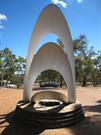
Innamincka Rd Greenmount
Blackboy Hill Camp
Mundaring
Metropolitan
Constructed from 1914 to 1992
| Type | Status | Date | Documents |
|---|---|---|---|
| Heritage List | YES | 08 Mar 2016 | |
| State Register | Registered | 31 Mar 2006 | HCWebsite.Listing+ListingDocument, HCWebsite.Listing+ListingDocument |
| Type | Status | Date | Documents |
|---|---|---|---|
| (no listings) |
| Type | Status | Date | Grading/Management | |
|---|---|---|---|---|
| Category | ||||
| Municipal Inventory | Adopted | 22 Apr 1997 | 1 - Exceptional significance | |
| Statewide War Memorial Survey | Completed | 01 May 1996 | ||
| Register of the National Estate | Permanent | 28 Sep 1982 | ||
| Classified by the National Trust | Classified {Lscpe} | 04 Dec 1980 | ||
Blackboy Hill Memorial is in good condition and appears to be well maintained.
| Name | Type | Year From | Year To |
|---|---|---|---|
| Ean McDonald | Architect | - | - |
| Library Id | Title | Medium | Year Of Publication |
|---|---|---|---|
| 7026 | Images CD No. 30 : assessment images : Blackboy Hill Site, Holmesdale, Mt Helena Tavern, Undercliffe. | C D Rom | 2004 |
Historic Site
| Epoch | General | Specific |
|---|---|---|
| Original Use | MONUMENT\CEMETERY | Monument |
| Present Use | MONUMENT\CEMETERY | Monument |
| Present Use | PARK\RESERVE | Park\Reserve |
| Style |
|---|
| Other Style |
| Type | General | Specific |
|---|---|---|
| Other | STONE | Other Stone |
| Other | STONE | Granite |
| Other | METAL | Other Metal |
| General | Specific |
|---|---|
| DEMOGRAPHIC SETTLEMENT & MOBILITY | Aboriginal Occupation |
| OUTSIDE INFLUENCES | World Wars & other wars |
This information is provided voluntarily as a public service. The information provided is made available in good faith and is derived from sources believed to be reliable and accurate. However, the information is provided solely on the basis that readers will be responsible for making their own assessment of the matters discussed herein and are advised to verify all relevant representations, statements and information.
Constructed from 1962, Constructed from 1914
The Blackboy Hill commemorative site has vey high social and historic significance for it's associations with WWI training camp, sustenance camp for the unemployed during the depression and as an administrative site.
The commemorative or memorial site is contained on a small piece of open parkland adjacent to the Greenmount Primary School and St Anthony's Church/School which are in turn surrounded by new housing subdivisions which have gradually reduced the site to a token of its original size. The site focusses on the commemorative memorial sculpture formed by metallic arcs scribing the sun's orbit through the sky. Low stone walls contain the space around the memorial which, despite the urban encroachment maintains a contemplative atmosphere.
The land on which the Blackboy Hill Commemorative site is located is said to have been used as an aboriginal camp-site. On 30th September 1829, the area became part of Captain James Stirling's 4,000 acre Swan. Location 16, "Woodbridge" Grant. A spring in the vicinity, shown on Surveyor Philip Chauncy's field notes accompanying his 1846 Survey of the York Road (Great Eastern Highway), was later said to have been used as a camp-site by Afghan camel teams. In 1883, Henry Brockman purchased Stirling's land, and in 1884, estate agent James Morrison unsuccessfully advertised the Blackboy Hill Estate and Blackboy Flats for sale. In October 1896, after the auction of adjacent land near the Swan View Tunnel (Site 178) and Hedges' Swan View lots, Morrison made a second more successful attempt to sell his land. However, following the completion of the Eastern Railway, "Mahogany Creek Deviation" and the Swan View Tunnel, little development took place. Part of Morrison's 1896 auction included the sale to Londoner Ernest Wood of Lots 100 (approximate size 62 acres), and the adjacent Lot 115, fronting the newly completed Eastern Railway. When war was declared on 4th August 1914, the Commonwealth Government acquired the land for an initial training camp. After a severe storm, the original bell-shaped canvas tents were eventually replaced by wooden huts, and on 16th October 1915, former State Premier Sir John Forrest, opened a YMCA Social Centre, erected by men from the Midland Junction Railway Workshops. Up until the end of World War I in November 1918, some 32,000 men (approximately 1 in 10, or 1/3 of all men aged 18-44 in Western Australia at that time), passed through the Blackboy Hill Camp. Nine of the ten Victoria Cross recipients trained at the Blackboy Hill Camp. The only exception was Hugo (Jim) Throssell (Sites 80 & 81). Between June and October 1919, the buildings were used as an "isolation hospital" for the treatment of Spanish 'flu (pneumonic influenza). It has been said that 1,519 patients were treated, staying between 4 and 41 days, with the average being a week. There were 79 fatalities. In the 1920's, the area was deserted, except for the annual Greenmount District Show and the Officers' Mess which was used as a dance hall. Early in the 1930's, and until c. 1935, at any one time, an estimated 1,000 unemployed single men were housed there while they undertook sustenance work in road building and the nearby Greenmount National Park, known from 1947 as John Forrest National Park (Site 169). the early stages of WWII (1939-1945), a railway stopping place was made nearby but the camp wasn't used during hte war, and the wooden buildings were relocated. However, after the war between 1945 and 1948, local resident Eric Leighton recalls the area being used for some sort of military training. After the war, the railway stop was relocated and renamed Blackboy Hill. Subsequent plans for the sub-division of the former camp-site for State Housing Commission houses was strongly rejected by returned service men and women and their organisations. As a result protests, early in 1951, partof the site was set aside as an ANZAC memorial reserve. The area was dedicated in Novemeber 1958, and in 1962, a distinctive sculpture was erected. It was designed by Architect Ean McDonald to reflect the ANZAC spirit and has it's axis on the line of the sunset on 24th April, ANZAC eve. Charle Court then Minister for Industrial Development and later Premier opened it, and the dedication was performed by Bishop Charles (Tom) Riley, a former chaplain at the WWI Blackboy Hill Camp. In 1963, an aviation beacon was erected on the site, and in the former camp-site. Other additions to the Blackboy Hill Camp-site include the Gallipoli Legion of ANZAC's seat in 1964; the planting in 1969 of a pine said to be descendant of one at Lone Pine (ANZAC Cove, Turkey) and an entrance structure in 1989. On 25th April each year, the site is used for the Shire fo Mundaring's main dawn service.
Integrity: The site's integrity as a memorial is very high but no element of the earlier uses remains. Modifications: none of the original camp buildings remain
Very Good
| Ref ID No | Ref Name | Ref Source | Ref Date |
|---|---|---|---|
| G Bolton; "A Fine Country to Starve In". 2nd Edition pp. 106-109, 136, 161-162, 179-180, 182, 184, 187 | UWA Press | 1994 | |
| MJ Bourke; "On the Swan". pp. 292-293. p.299 | |||
| Letters; Eric Leighton of Greenmount. | 1996 | ||
| I Elliot; ibid pp. 120, 212, 213, 228-231, 241 |
| Owner | Category |
|---|---|
| Shire of Mundaring | Local Gov't |
This information is provided voluntarily as a public service. The information provided is made available in good faith and is derived from sources believed to be reliable and accurate. However, the information is provided solely on the basis that readers will be responsible for making their own assessment of the matters discussed herein and are advised to verify all relevant representations, statements and information.
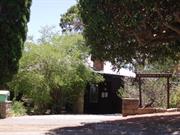
11 Old York Rd Greenmount
Katharine's Place
Megalong
Mundaring
Metropolitan
Constructed from 1896 to 1929
| Type | Status | Date | Documents |
|---|---|---|---|
| Heritage List | YES | 08 Mar 2016 | |
| State Register | Registered | 28 Feb 1995 | HCWebsite.Listing+ListingDocument, HCWebsite.Listing+ListingDocument |
| Type | Status | Date | Documents |
|---|---|---|---|
| (no listings) |
| Type | Status | Date | Grading/Management | |
|---|---|---|---|---|
| Category | ||||
| Municipal Inventory | Adopted | 22 Apr 1997 | 1 - Exceptional significance | |
| Register of the National Estate | Permanent | 16 Apr 1991 | ||
| Classified by the National Trust | Classified | 04 Nov 1983 | ||
| Survey of Women's Employment AHC | Recorded | 01 Sep 2002 | ||
| Library Id | Title | Medium | Year Of Publication |
|---|---|---|---|
| 12157 | Katharine's place - Greenmount, Architectural evaluation for the Western Australian Heritage Committee | Heritage Study {Other} | 1987 |
| 81 | Katharine's Place, Greenmount : conservation report. | Heritage Study {Cons'n Plan} | 1993 |
Individual Building or Group
| Epoch | General | Specific |
|---|---|---|
| Present Use | SOCIAL\RECREATIONAL | Other Community Hall\Centre |
| Original Use | RESIDENTIAL | Single storey residence |
| Type | General | Specific |
|---|---|---|
| Other | STONE | Granite |
| Wall | TIMBER | Weatherboard |
| Roof | METAL | Corrugated Iron |
| General | Specific |
|---|---|
| PEOPLE | Famous & infamous people |
| DEMOGRAPHIC SETTLEMENT & MOBILITY | Settlements |
This information is provided voluntarily as a public service. The information provided is made available in good faith and is derived from sources believed to be reliable and accurate. However, the information is provided solely on the basis that readers will be responsible for making their own assessment of the matters discussed herein and are advised to verify all relevant representations, statements and information.
For 50 years,,,,, 1919- 1969, The distinguished Australian and International writer, Katherine Susannah Prichard (wife of Capt. Hugo Throssel V.C>) lived and worked in this simple cottage and adjacent workroom where she wrote on social conditions against Western Australian backgrounds. The buildings are regarded as an important memorial by organisation of writers, the Shire of Mundaring and visitors from overseas. The wild garden is an important characteristic of the setting.
The original, 1896 cottage of typical period timber construction with iron roof consisted of 4 small rooms with surrounding verandahs. The western verandah has been converted into a pergola, that on the south enclosed and that on the east replaced recently by two lightly constructed rooms. The parlour and the kitchen have been opened into one room. About 30 metres to the east a timber work room was built for the writer. The garden and buildings lie on a steep slope to the north west looking through trees to the coastal plain.
Assessment 2011 Construction 1896
This information is provided voluntarily as a public service. The information provided is made available in good faith and is derived from sources believed to be reliable and accurate. However, the information is provided solely on the basis that readers will be responsible for making their own assessment of the matters discussed herein and are advised to verify all relevant representations, statements and information.
Constructed from 1929, Constructed from 1896
Katharine's Place has very high historic significance for it's associations with Katharine Susannah Pritchard, Hugo Throssell VC and the Rev. Percy U Henn; very high social significance as a writer's centre, an illustration of a writer's way of life and as a typical turn of the century semi-rural house/lifestyle; and high aesthetic significance for the house in it's rambling garden setting complete with very large, old pine tree that provides something of a local landmark.
Katharine's Place is located in rambling gardens moulded around the natural slope and granite features of its Greenmount site. A very large old pine tree on the site provides a landmark for the surrounding neighbourhood. Various elements of granite stonework such as the pergola columns and low walls provide a comfortable transition between the timber, weatherboard house and its 'natural' garden setting. The 1896 weatherboard house, originally of typical four roomed plan with central passage and surrounding verandas is still intact although some veranda enclosures have modified its form. The roof is of corrugated iron, in typical hipped form. Outbuildings, comprising wash-house, WC and Katharine Susannah Prichard's 1929 writing studio are also of weatherboard and compliment the house. The exception is the modern carport attached to the old wash-house. Unfortunately the old WC is collapsing under the weight of an old pine tree and vines. Internally, the four main rooms of the house retain their lath and plaster walls and ceilings, unadorned by ceiling roses or cornices. Floors and skirting are of timber and doors are four panelled type. For more complete descriptions of the place and its significance, see the Heritage Council of WA descriptions for Interim Register Entry and Campbell, R.McK., and van Bremen I.H., Katharine's Place, Greenmount: Conservation Report (June 1993).
Katharine Susannah Prichard's house in Old York Road, Greenmount, was built in c. 1896 by a tenant on land owned by auctioneer and former Visiting Magistrate, James Morrison. The land had been part of Captain James Stirling's original 4,000 acre Swan Location 16, later owned by Henry Brockman. In 1910, part of the land, including Lot 51, which contained the four room home, and the adjoining Lot 52, were purchased and used as a weekender by Guildford Grammar School founding Headmaster, Rev. Percy Henn. In c. 1919/1920, the 2 lots, and 140 acres to the south of the York Road (Great Eastern Highway) were purchased by Hugo (Jim) Throssell, V.C. Winner and son of former State Premier and Northam identity, George Throssell. In Melbourne in January 1919, Hugo Throssell had married Fijian-born writer, Katharine Susannah Prichard, and moved to Western Australia. Their association with the Greenmount house continued until Katharine died in October 1969. Katharine Susannah Prichard's writing reflected her interests in social and political issues, and whilst at Greenmount she enhanced her already established literary reputation with novels such as Working Bullocks (1926) and Coonardoo (1928). She helped establish the W.A. Branch of the Communist Party and was actively involved in the W.A. Fellowship of Writers. During the 1920's and 1930's, changes tot he property included the establishment of the garden addition of a northern aspect verandah, and a separate weatherboard workroom, financed by prize money Katharine received fo rthe novel "Coonardoo". Following Jim Throssell's suicide in 1933, few changes were made to the house until the 1970's, when after Katharine Susannah Pritchard's death, P & S Lewis altered the garden and house, opening it as "Megalong Gallery" in 1974. A plaque was placed on the house to celebrate the centenary of Katharine Susannah Pritchard's birth in 1884. In 1984, the State Government purchased Lot 51 and vested it in the Shire of Mundaring. At Present the house is on a 21 year lease to the Katharine Susannah Pritchard Foundation who use the property for a Writer in Residence programme and literary meetings.
Integrity: High, despite modifications over the years and adaption as a writer's centre. Modifications: Verandah enclosures.
good, sound condition
| Ref ID No | Ref Name | Ref Source | Ref Date |
|---|---|---|---|
| HCWA assessment for Katharine Place1681 | HCWA | ||
| R MCK Campbell, IH van Bremen; "Katharine's Place Greenmount: Conservation Report". | 1993 | ||
| I Elliot; ibid pp. 212-213 |
| Owner | Category |
|---|---|
| WA Government | State Gov't |
| Vested in the Shire of Mundaring | Local Gov't |
This information is provided voluntarily as a public service. The information provided is made available in good faith and is derived from sources believed to be reliable and accurate. However, the information is provided solely on the basis that readers will be responsible for making their own assessment of the matters discussed herein and are advised to verify all relevant representations, statements and information.
1240 Mundaring Weir Rd Hacketts Gully
Mundaring
Metropolitan
Constructed from 1902
| Type | Status | Date | Documents |
|---|---|---|---|
| (no listings) |
| Type | Status | Date | Documents |
|---|---|---|---|
| (no listings) |
| Type | Status | Date | Grading/Management | |
|---|---|---|---|---|
| Category | ||||
| Municipal Inventory | Adopted | 22 Apr 1997 | 1 - Exceptional significance | |
16610 Goldfields Water Supply Scheme
| Name | Type | Year From | Year To |
|---|---|---|---|
| C.Y. O'Connor | Architect | - | - |
| Library Id | Title | Medium | Year Of Publication |
|---|---|---|---|
| 7353 | Conservation plan for Goldfields Water Supply Scheme. Volume II, place B : No. 2 Pumping Station, O'Connor. | Heritage Study {Cons'n Plan} | 1999 |
Historic Site
| Epoch | General | Specific |
|---|---|---|
| Original Use | GOVERNMENTAL | Pumping Station |
| Present Use | GOVERNMENTAL | Pumping Station |
| General | Specific |
|---|---|
| SOCIAL & CIVIC ACTIVITIES | Community services & utilities |
This information is provided voluntarily as a public service. The information provided is made available in good faith and is derived from sources believed to be reliable and accurate. However, the information is provided solely on the basis that readers will be responsible for making their own assessment of the matters discussed herein and are advised to verify all relevant representations, statements and information.
Constructed from 1902
The No. 2 Pumping Station has high historic significance for it's associations with the history of the Goldfields Pipeline.
The old No. 2 Pumping Station site comprises only the remains of footings and floor slabs of several buildings together with some concrete machinery dotted around the site amongst several significantly large Norfolk Island and Radiata pine trees.. The site houses some large sections of pipeline, some purported to be lengths of the original pipe.
The No. 2 Pump was part of the 1898-1903 Goldfields Water Supply Scheme which pumped water fromt he Helena Reservoir created by the Mundaring Weir, tot he Eastern Goldfields at Coolgardie and kalgoorlie. In common with all seven other pumping stations, it was built of brick with a corrugated iron roof and concrete floor. The boilers for this pumping station were originally wood fired and required in an average month 317 tonnes (215 cords) compared to 392 tonnes for the No. 1 Pumping Station. From 1902-1926, 3650 acres (1,477 hectares) were cut to supply to No. 2 pump. Cut wood specified as solid, dry, jarrah logs measuring between 6 and 61/2 feet long and less than 7 inches in diameter was cut bu contractors and stacked up near the pumping station. In 1927, the railway platform adjacent to the No. 2 Pumping Station was named O'Connor in memory of Charles Yelverton O'Connor, the State's Engineer-In-Chief who designed the water supply scheme but did not live to see the first successful pumping of water in April 1902. In 1954, both the No. 1 No. 2 Pumps were phased out and replaced by one electric pump at the Weir.
Integrity: Low
Ruins
| Name | Type | Year From | Year To |
|---|---|---|---|
| C.Y. O'Connor | Architect | 1898 | 1902 |
| Ref ID No | Ref Name | Ref Source | Ref Date |
|---|---|---|---|
| MHHS File; "Mundaring Weir". | |||
| I Elliot; ibid pp. 121, 130-140 |
This information is provided voluntarily as a public service. The information provided is made available in good faith and is derived from sources believed to be reliable and accurate. However, the information is provided solely on the basis that readers will be responsible for making their own assessment of the matters discussed herein and are advised to verify all relevant representations, statements and information.
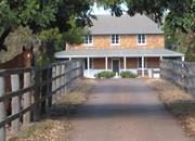
Clayton Rd Helena Valley
Clayton Rd West access from Samson Street
Mundaring
Metropolitan
Constructed from 1861 to 1971
| Type | Status | Date | Documents |
|---|---|---|---|
| Heritage List | YES | 08 Mar 2016 | |
| State Register | Registered | 14 Mar 2008 | HCWebsite.Listing+ListingDocument, HCWebsite.Listing+ListingDocument |
| Type | Status | Date | Documents |
|---|---|---|---|
| (no listings) |
| Type | Status | Date | Grading/Management | |
|---|---|---|---|---|
| Category | ||||
| Classified by the National Trust | Classified | 12 May 2003 | ||
| Register of the National Estate | Indicative Place | |||
| Municipal Inventory | Adopted | 22 Apr 1997 | 1 - Exceptional significance | |
The various structures which comprise Clayton Farm are generally in good condition. While the lower brick courses of Clayton Farm House have been rendered there is no sign in the brickwork above the render of fretting mortar or bricks. There is fretting to some of the bricks on the south east side of the chimney stack but this is not extensive and may represent wind erosion. The cellar of the small cottage displays evidence of rising damp but this appears to be under control at present. Both the brick lined wells are in good condition. The well near the house was repaired in 1972 when a new coping and a gable roof were installed.
Individual Building or Group
| Epoch | General | Specific |
|---|---|---|
| Present Use | RESIDENTIAL | Two storey residence |
| Original Use | FARMING\PASTORAL | Homestead |
| Original Use | FARMING\PASTORAL | Servants or Shearers Quarters |
| Style |
|---|
| Victorian Georgian |
| Vernacular |
| Type | General | Specific |
|---|---|---|
| Wall | RENDER | Other Render |
| Roof | TIMBER | Shingle |
| Roof | METAL | Corrugated Iron |
| Wall | BRICK | Handmade Brick |
| General | Specific |
|---|---|
| DEMOGRAPHIC SETTLEMENT & MOBILITY | Land allocation & subdivision |
| DEMOGRAPHIC SETTLEMENT & MOBILITY | Immigration, emigration & refugees |
| OCCUPATIONS | Grazing, pastoralism & dairying |
| PEOPLE | Early settlers |
This information is provided voluntarily as a public service. The information provided is made available in good faith and is derived from sources believed to be reliable and accurate. However, the information is provided solely on the basis that readers will be responsible for making their own assessment of the matters discussed herein and are advised to verify all relevant representations, statements and information.
Clayton Farm, which consists of a double storey brick and iron residence in the Victorian Georgian style, a single storey brick and iron cottage and a brick lined well have cultural heritage significance for the following reasons: . the place represents part of the original system of grants that were first established in Western Australia; . the place is associated with the development of Western Australia's agricultural industry and the fledgling colony's efforts to become self-sufficient; . the place has retained a high degree of integrity and authenticity and is the oldest farmhouse on the Helena River; . the place is associated with Richard and Mary Smith who were amongst the earliest colonists to arrive in Western Australia; . the place is ideally placed in its rural environment and is a fine example of the Victorian Georgian style; . the place has the potential to contain archaeological deposits which would provide additional information on early colonial life; and, . the place is held in high esteem by the Smith's descendants.
Clayton Farm comprises a double storey brick and iron residence in the Victoria Georgian style, a single storey brick and iron cottage with cellar, a brick lined well on the northern side of the residence and the remains of a well, orchard and possible habitation site to the south of the residence on the banks of the Helena River. The place is located in a semi-rural environment on the floodplain of the Helena River. The residence is constructed of soft fired bricks laid in flemish bond. The front section of the building, which is only room deep, is double storey while the rear portion of the building ,s single storey. The double storey section is covered with a hipped roof, while a steeply pitched skillion roof covers the single storey section. A single storey, skillion roofed verandah protects the front and sides of the house. The verandahs have concrete floors with stop chamfered posts set into metal stirrups. The lower part of the walls have been rendered to a height of approximately 80 cm above the verandah floor. A single storey addition was made to the rear of the house in 1971 using soft fired bricks rescued from a demolished building in Guildford. The addition is covered with a flat roof. This section has incorporated the original, detached kitchen wing into the main house. The wing has a gable roof and the eastern wall has been rendered. The front facade has three easement windows, evenly spaced across the upper floor white the lower floor has easement windows set on either side of the main door. A double hung sash window is located towards the rear on the southern side. This window is not original. The front door features a solid, six panel front door, with rim lock and a three paned fanlight. A brick chimney stack rises from the eastern edge of the hipped roof towards the southern side of the house. The upper storey brickwork features four diamond patterns (formed from header bricks), evenly spaced across the facade between the windows. The two outer diamonds feature dark coloured header bricks, while the two inner diamonds are light coloured header bricks. The brickwork within these diamonds contains the initials of Richard and Mary Smith's children and the date that the house was constructed (1861). The front door opens onto a wide entry hall with a staircase on the northern side and single rooms on either side of the hall. The staircase leads up to single rooms on either side of the stair lobby. The interior was renovated during the 1990s and the original brickwork covered with gyprock sheeting and the ceilings replaced with gyprock sheeting and plaster cornices. The original floorboards, staircase and timber joinery have survived. The front bedroom on the southern side has a timber mantle piece with a cast iron firebox. These are not original. The central hall on the ground floor opens out onto a lounge room with a kitchen on the northern side. The ceiling in this section of the house is open leaving the original shingles (which are now covered with CGI) visible. Some of the original floorboards have been replaced in the lounge room, the boards in the kitchen are covered with vinyl. The fireplace features an elaborate Federation style timber mantle piece which is not original. The kitchen has modem fittings and fixtures. On the eastern side of these two rooms is a large sunroom which stretches across the width of the house. This was constructed in 1971 and features recycled timber boards, french doors on the eastern and northern sides a set of three easement windows on the southern side, plaster walls and ceiling. The formerly detached kitchen wing has been renovated to function as a laundry and bathroom. It has new fittings and fixtures. The brick cottage to the east of the house also features flemish bond brickwork with the lower section of the wall rendered. A skillion roofed verandah on the western side is supported by treated pine posts. The roof is covered with new shingles. Access to the building is via a ledged, braced and sheeted door on the western side of the building which is accessed via two steps. The door leads into a single room with easement windows on the western and eastern sides. The floor is tongued and grooved boards, with a coved, tongued and grooved ceiling. A modern laundry and bathroom annex (constructed with vertical, timber boarding), has been built on the northern side. A cellar is located beneath the main room and is accessed by exterior steps on the southern side. The walls are rendered to approximately 80 cm above a concrete floor. A small opening, with bars, is located on the western side. The room floods regularly in winter and has been fitted with a pump to prevent this. A brick lined well is located on the north side of the house. Renovations were made to this well in 1972 and included the construction of a new stone coping, approximately 80 cm above ground, surmounted by an open gable roof supported on treated pine posts and clad with shingles. A plaque records that the well was 'restored' to mark the reunion of descendants of Richard and Mary Smith on 22 October 1972. Approximately 500 metres to the south west of the house, near the bank of the Helena River, are the remains of an orchard, a cleared open space and a filled in well. This well was originally used by the Smith family and had better quality water than the well close to the house. An old orange tree and mulberry tree are all that remain of the orchard. The Smith family may have occupied this site when they first moved out to Clayton Farm in the 1840s.
Assessment 2003 Construction 1861 Architect/designer: Richard Smith Builder: Smith family Henry Camfield arrived in the Swan River colony in October 1829 aboard the Caroline. He was accompanied by Richard and Mary Smith, Frederick and Frances Friend and Richard Bardon his indentured servants. Camfield was initially granted Swan Loc. 35 (1,000 acres) which Camfield called Burrswood'. In November 1829 he was also granted Helena LOG. 20b (1,186 acres) on the Helena River. Camfield leased his Helena Location to a settler to carry out his location duties, but by 1839 no buildings or yards had been constructed on the grant. During this early period, settlers experienced cash flow problems and Camfield was no exception, By November 1830, Camfield had cancelled Smith's indenture, probably because he was unable to provide for him. Smith was a carpenter by trade and he managed to survive by getting commissions, such as building Stirling's 'cottage ornee' at Woodbridge. Camfield sold the Helena property to Smith in April 1854. However, the Smith family (by this stage Richard and Mary had six children), appear to have occupied the location prior to this date as Chauncey's survey of York Road in 1846 notes a 'track to Smith's' on the southern side of York Road. The name Clayton's Farm was apparently given to the property by one of Camfield's earlier leasees. RichardSmith established a thriving farm on the property and by 1861 had completed his two storey house. The bricks for the house were apparently made on the property. Smith was assisted by a number of ticket-of-leave-men between 1857 - 1870 who no doubt assisted with the construction of the house and a number of out buildings: a five stall stable, a separate cottage with coach house attached for farm hands, barns and pig pens. During the early years, Smith had his wheat ground at Cruse's mill at Upper Swan. Richard died in 1878 and the running of the farm passed to his third son George. His eldest son John had established a property out at Northam and Alfred had initially purchased a farm at 'Wongamine' before coming back to establish a sawmill at Smith's Mill (Glen Forrest). When Mary Smith died in 1891, Alfred moved with his family down to Clayton and assisted his brother George with the running of the farm. The brothers started to sell off portions of land in 1902, although the bulk of the property was sold to Katharine Samson in April 1906. During the 1920s, Mrs Samson sub-divided the location into orchard blocks. The land on which the farmhouse and outbuildings was now located, Lot 27, was reduced to 26 acres and 3 perches. Lot 27 was purchased by Goldsborough Mort in April 1924. They had also purchased lots 18 19, 24, 25 and 26 which contained riverside pastures which were used by Goldsborough Morth (which later became Elders Goldsborough Mart) as holding paddocks for stock prior auction at the sale yards at Midland Junction. Clayton Farm was used as a manager's residence. The property was sold at auction to Innes Pty Ltd in November 1968. Prior to the auction the various outbuildings were demolished, with the exception of the small brick cottage to the east of the house. Innes Pty Ltd was owned by the Dick Family (David and Dorothy Dick). The house had been unoccupied for approximately a year before the Dick family's purchase and before they moved in, the Dicks renovated the house, adding a sun room across the rear of the house. The addition of this sun room incorporated the detached kitchen into the house. A modern asbestos cement house was placed on the north east corner of the lot in 1971. Initially this house was used by caretakers until David and Dorothy Dick moved there in the 1990s. The original 1861 house is currently occupied by David and Dorothy's son Graeme and his family. A family re-union of the descendants of Richard and Mary Smith was held in the grounds of Clayton Farm in October 1972. The place was placed on the National Trust's Recorded list in August 1971 and on the Shire of Mundaring's Municipal Inventory in April 1997
This information is provided voluntarily as a public service. The information provided is made available in good faith and is derived from sources believed to be reliable and accurate. However, the information is provided solely on the basis that readers will be responsible for making their own assessment of the matters discussed herein and are advised to verify all relevant representations, statements and information.
Constructed from 1861, Constructed from 1971
Clayton Farm has very high social, historic and aesthetic significance for the Shire of Mundaring and State as. one of few remaining examples of early colonial lifestyle and building. Its aesthetic significance is advanced considerably in having survived on a larger 'urban' farm lot which also provides an interpretation of its social and historic context.
Clayton Farm is located on an urban farm property above the north bank of the river in the Helena Valley. The retention of horse paddocks around the house has kept the property in a contextual setting as adjacent land has gradually been subdivided for housing. The property is approached along a driveway from Samson Street, on the west, giving a full view of the two-storey house in a garden setting. Formerly the house was approached from the north. The property still retains a brick outbuilding, possibly servants' quarters or schoolroom, which is raised several steps above ground level over a brick cellar. More recent outbuildings in the form of garages and workshop are sympathetically built of unpainted weatherboard and corrugated iron. Several old wells remain on the property, including a brick lined well some 5-6 metres deep to the north of the house which is thought to have supplied stock and washing water and is never dry. A timber-lined well/soak in a paddock to the south is thought to have supplied excellent qualitydrinking water. A third well, brick lined and also continuous in supply, existed close to the river, but has now been filled in. The two storey clay brick house, with surrounding verandas, is an important example (as well as one of few remaining in such excellent condition) of the simple Colonial Georgian character of the early days of the colony. Decoration is minimal and simple. The veranda is probably original but could have been a very early addition, prior to which possibly only a typical Georgian entry porch may have graced the front of the house. Decoration externally is limited to the incorporation of diamond shapes into the bonding of the brickwork between windows on the upper walls. The two end diamonds are of darker bricks forming a contrast in the wall. Etched, unobtrusively, into the bricks at the centre of each diamond are the date 1861 and the initials of Richard Smith and his family members. The original section of the house has four rooms; two either side of a front door and central hall which incorporates a narrow stair to the first floor. To the rear, on the ground floor a circa late 1960's flat roof addition has provided additional living space and extended the house out to meet what was previously the separate brick (now rendered) kitchen pavilion, (now bathroom). The walls of the extension are built of matching recycled bricks and it has been carefully integrated despite its flat roof. It could be argued the extension would have been more sympathetic with a pitched roof, however this may have been at the expense of greater interference with the original fabric and the flat roof now serves to identify the new from the original work. The lower half of the external walls have been rendered to control fretting bricks which are quite soft; however, the problem may have been exacerbated by the earlier replacement of the timber veranda with concrete which could have aggravated rising damp problems. Of the four original rooms on the ground floor, the two to the rear are single storey and forma lean-to against the front two storey section. The two storey section of the house is only one room deep, comprising two bedrooms on the first floor, one either side of the stair over similar sized rooms on the ground floor. However, their integrity remians intact whilst their authenticity, which may be less evident, can still be reasonably ascertained. Original shingles are still exposed on the underside of the rear lean-to roof, which has never had aceiling lining. According tot he current owners (since 1968), the two front rooms on both floors originally had low 'mini-orb' ceilings which have now been replaced with flat plasterboard and coved cornices. Internal doorways are low and some of the mullioned casement windows have larger panes at the centre and smaller (narrower) panes to the outside.
Integrity: Very High- although legitimate adaption over the years has diminished some original uses of element. Modifications: Rear flat roofed addition.
Very Good
| Ref ID No | Ref Name | Ref Source | Ref Date |
|---|---|---|---|
| I Elliot; ibid. pp 216-217, 224 | |||
| MHHS, Elliot Research Notes on "Helena Valley", |
This information is provided voluntarily as a public service. The information provided is made available in good faith and is derived from sources believed to be reliable and accurate. However, the information is provided solely on the basis that readers will be responsible for making their own assessment of the matters discussed herein and are advised to verify all relevant representations, statements and information.
Lot 10159 Great Eastern Hwy Hovea
John Forrest National Park PERMANENTLY REGISTERED 14/2/03 AS PART OF 2660
Bridle/Walk Trail
Mundaring
Metropolitan
Constructed from 1882, Constructed from 1894
| Type | Status | Date | Documents |
|---|---|---|---|
| Heritage List | YES | 08 Mar 2016 | |
| State Register | Registered | 24 Jul 1992 | HCWebsite.Listing+ListingDocument |
| Type | Status | Date | Documents |
|---|---|---|---|
| (no listings) |
| Type | Status | Date | Grading/Management | |
|---|---|---|---|---|
| Category | ||||
| Municipal Inventory | Adopted | 22 Apr 1997 | 1 - Exceptional significance | |
| Classified by the National Trust | Permanent | 12 Jun 1989 | ||
| Classified by the National Trust | Classified | 12 Jun 1989 | ||
02660 Eastern Railway Deviation
| Name | Type | Year From | Year To |
|---|---|---|---|
| Charles Yelverton O'Connor | Architect | - | - |
| Library Id | Title | Medium | Year Of Publication |
|---|---|---|---|
| 6605 | Register of historic sites. | Report | 1988 |
Historic site
| Epoch | General | Specific |
|---|---|---|
| Present Use | Transport\Communications | Rail: Other |
| Other Use | OTHER | Other |
| Original Use | Transport\Communications | Rail: Other |
| Type | General | Specific |
|---|---|---|
| Other | CONCRETE | Other Concrete |
| Other | METAL | Steel |
| General | Specific |
|---|---|
| TRANSPORT & COMMUNICATIONS | Rail & light rail transport |
This information is provided voluntarily as a public service. The information provided is made available in good faith and is derived from sources believed to be reliable and accurate. However, the information is provided solely on the basis that readers will be responsible for making their own assessment of the matters discussed herein and are advised to verify all relevant representations, statements and information.
Constructed from 1882, Constructed from 1894
The Eastern Railway reserves have very high significance to the State of Western Australia and in particular for the residents of the Shire of Mundaring. They have aesthetic and landscape significance for the areas they pass through and the pedestrian access they provide for the public. The Wooroloo Culvert and the Swan View Tunnel have particular aesthetic appeal for provoking ta sense of romance with the rail era. The reserves have historic and social significance for the impact on the development of the State abd the impact on peoples' lives. The walk trails today have high social significance for the recreation facility they provide for the community. The Eastern Railway reserves have scientific significance as an illustration of the engineering required in their construction as evidenced by the Swan View Tunnel, Wooroloo Culvert, trestle bridges and the numerous cuttings and embankments that still remain.
The rails and sleepers have long since been removed from most of the extensive network of railway reserves throughout the Shire. The most significant legacy that remains is the low gradient bridle and walk trails that now follow the paths left by the original railway lines together with several major structures and associated buildings. The walk trail system along the reserves was a programme undertaken for the 1988 Bi-centennial celebrations, at which time the areas around the original township railway stations were rehabilitated. A series of information shelters were also installed to provide a modicum of protection and house interpretive material relevant to the railway history and flora and fauna in that location. Many of these shelters have fallen into disrepair or have been vandalised. In the late 1980's, some sections of the reserves were also used as the route for the telecommunications optic fibre link to the Eastern States, the installation of which assisted with the rehabilitation of many sections of the trail network. The trail along the reserves provides an informative historical record in itself as the engineering involved with its construction is illustrated by the extent and size of cuttings and embankments necessary to navigate through inhospitably hilly railway terrain. Good examples of this can be seen either side of the Darlington townsite with a deep cutting on the west along the edge of the Darlington Oval and a high embankment across the Nyaania Brook as the line moves east on its way to Glen Forrest. Remaining built structures along the reserves are few but fall into several categories. Firstly, the remains of old platforms which generally identifies some of the locations of stations in the townsites. Secondly, there are engineering structure which remain as a monument to the technology of the day required to construct the railway. In many cases the structures of the bridges have been removed however a few examples exist such as the significant construction of the Swan View Tunnel in the John Forrest National Park . Three trestle bridges in the park remain but are buried in earth embankments used to stabilise them at a later time. A concrete bridge across the Jane Brook in the main picnic area of the park is a more prominent reminder but was not part of the original installation. The aesthetically pleasing arched stone culvert over the Wooroloo Brook, in Werribee Road, Wooroloo is one of the few remaining structures that captures some of the former romance of the railways. It has been well crafted and engineered and is still in exceptionally good condition. The third category of structures are just off the actual lines and comprise the former railway houses of which only a few remain. These include the weaterboard Station-Master's House in Glen Forrest; the brick Station-Master's House in Jacoby Street, Mundaring and the Wooroloo Station-Master's House on the corner of Werribee and Government Roads. Glen Forrest and Mundaring are owned by the Shire and the Wooroloo house is now in private hands. They are all in reasonable condition but need to be maintained, particularly the weatherboard house at Glen Forrest which is under going restoration to become the base for the Mundaring Historical Society, and the Glen Forrest Residents and Ratepayers Association.
The Eastern Railway had an enormous impact on the area now covered by the Shire of Mundaring. Initially it;s construction created both direct and indirect employment. In most cases settlements which arose as service centres remain as today's local communities. The railway provided the means of relatively rapid and large scale transport for the important timber, quarrying, viticulture and agricultural industries. It allowed the movement of people for employment, recreation and education. By transporting mail, communications were facilitated between localities. For a period between the mid 1880's and the 1930's, the Eastern Railway replaced the York Road as the area's principle lifeline. On a statewide basis, it provided a link between Fremantle, Perth and the inland agricultural, pastoral and gold mining areas. The first section of the Eastern Railway was constructed from Fremantle to Guildford and was officially opened on 1st march 1881. The successful tender John Robb, in common with the subsequent builders of the Eastern Railway, James Wright, Edward Keane and Smeaton & Hedges, came form South Australia. This is most likely because by the early 1880's. the South Australian economy, which had shown substantial growth from c.1875, was on the decline. The experienced contractors bought men and equipment by sea from Adelaide to Fremantle. After much debate and political lobbying during the first phase of construction, the Legislative Council decided that York should be the terminus of the Eastern Railway. In September 1881, the 53,043/10/9 pound contract for the second section from Guildford to Chidlow's Well was let to James Wright of Adelaide. He brought with him 610 tonnes of stores and equipment and 28 draught horses. His brother Arthur was in charge of the main construction camp located near the Government Quarry at Greenmount. The main camp held up to 200 men and contains a workshop and forge. Further along the line were six smaller camps for the men blasting the cuttings with dynamite. After clearing 40 metres either side of the track, embankments were formed using the draught horses, heavy lpoughs and barrow men. The timber for the railway sleepers was supplied by the steam mill Wright had installed at what is now Mt Helena. The 30 men employed at the mill could produce 300 sleepers a day and by March 1883, they had provided 17,300. Ballast in the form of blue metal was taken from the Greenmount Quarry near the main construction camp. The earthworks took 2 years to complete and several delays were experienced. Problems with clay at 'Devil's Terror' cutting neat what is now the eastern end of Dairy Road, Darlington necessitated a diversion south-east and an extra 3 months of work at a cost of approximately 6,634 pounds. This took the line closer to Nyaania Creek, resulting in its permanent re-routing. Once the earthworks were completed, the rails were ballasted at the rate of 500 metres per day. Four stations were built at Greenmount, Smiths Mill, Sawyers Valley and Chidlow's Well. The presence of the railway terminus was a boon to Chidlow's Well, which in November 1883, became the first gazetted townsite in what is now the Shire of Mundaring. The line was officially opened on 11th March 1884. On 22nd October 1883, the £ 105, 312/16/- contract for the final section from Chidlow's Well to York was let to 39 year old South Australian Edward Keane. Keane had worked with Wright on the second section and used both Wright's mill at Mt Helena and the expertise of his manager Thomas Riseley to complete the work. A workforce of over 600 men and 122 horses worked on the line, which did not encounter the same problems as the section from Guildford to Chidlow's Well. The Eastern Railway to York was officially opened by Governor Broome on 29th June 1885. Keane went on to build the privately owned Midland Railway from Midland Junction to Walkaway and the Upper Darling Range Railway from Canning Mills to Midland Junction. With the construction of the Eastern Railway came the extension of saw milling activities on leased Crown land and improved accessibility for those already operating. These included Alfred and Thomas Smith at the York Greenmount Sawmill at Smiths Mill, Edmund Lacey who moved from Mahogany Creek to Sawyers Valley, and Alexander Forrest's Smith and Company. In addition it provided support for vignerons and orchardists such as Alfred Waylen at Darlington Vineyard (Site 131), Richard Hardey at Smiths Mill (Site 115), Charles Byfield at Mahogany Creek (Site 161), and Peter Gugeri at Mundaring (Site 20). Soon after it was opened various problems began to surface Within months of its completion, an accident at 'Cape Horn' near Boya, highlighted difficulties with the railway's sharp curves and steep grades of 1 in 30. In addition, problems arose with providing a reliable clean water supply. This was eventually solved with the building of a reservoir near Chidlow's Well which is now Lake Leschenaultia (Site 200). Another problem for the Eastern Railway occurred when the opening up of the Eastern Goldfields escalated operating costs, and showed the original design to be inadequate for the increased volume and heavier traffic. As a result of these factors, Chief Engineer C.Y. O'Connor, who came to Western Australia for the Fremantle Harbour project, was instructed to find an alternative route through the Darling Range. In March 1892, railway engineer John Muir gave a report to O'Connor which indicated that the best route was along Jane Brook. In November 1893, Adelaide firm Smeaton and Hedges were awarded the £ 47, 608/19/- contract to build the misnamed 'Mahogany Creek Deviation' from Bellevue to Lion Mill (Mt Helena) via a tunnel to be built through the rock at Swan View (Site 178). In February 1894, the main construction camp was set up at the site of the tunnel and men with picks, shovels and horses built 58 culverts and 6 jarrah trestle bridges. In the 1920s and 30s, these bridges were eventually replaced by steel, except for the 114 metre long one in John Forrest National Park which was covered by gravel and an earth embankment (Site 169). Similar problems to those encountered on the second section of the original Eastern Railway occurred here. As a result of rock slides, construction delays were experienced. Cuttings had to be widened and the Swan View Tunnel lined with bricks. The official opening of the line occurred on 22nd February 1896, and the first passenger train ran on 2nd March 1896. The original stations on this route were at Swan View and Parkerville. Within 4 months of the line's opening, there was a serious accident when in June 1896, a man and 8 horses were killed when part of a train became uncoupled at Lion Mill and crashed in the Greenmount National Park just above the Swan View Tunnel. The lack of ventilation in the tunnel caused serious problems with train crews experiencing blackouts on the up hill journey. The most serious accident occurred in November 1942 when driver Thomas Beer was killed in a derailment caused by a number of factors including the presence of chaff on the line, the train's heavy load and the lack of ventilation in the tunnel. The problem was addressed with the opening on 25th November 1945 of an open cutting for uphill traffic. The Eastern Railway 'Mahogany Creek Deviation' remained the rail link to the eastern states until the dual gauge route via the Avon Valley was opened on 15th February 1966. Before that time, the line through Glen Forrest closed gradually over the period from 1952 to the early 1960's. Since the closure of the railway, the reserves have been set aside as heritage walk trails with interpretive material located near the former stations.
Integrity: Overall the reserves integrity is low in terms of functional use but high for recreation and heritage. Modifications: Most original structures have been demolished
variable, from non existent and in ruins to good/fair for the Wooroloo stone culvert
| Name | Type | Year From | Year To |
|---|---|---|---|
| CY O'Connor | Architect | - | - |
| Ref ID No | Ref Name | Ref Source | Ref Date |
|---|---|---|---|
| I Elliot; ibid pp. 55, 57, 77-79, 81, 102, 111-113, 136, 163, 177, 233-238. | |||
| L Watson; "Railway History of Midland Junction". pp.109, 120-131 |
| Owner | Category |
|---|---|
| Conservation Commission | State Gov't |
This information is provided voluntarily as a public service. The information provided is made available in good faith and is derived from sources believed to be reliable and accurate. However, the information is provided solely on the basis that readers will be responsible for making their own assessment of the matters discussed herein and are advised to verify all relevant representations, statements and information.
Lot 10159 Great Eastern Hwy Hovea
Near Curve Road - Eastern Railway Reserve Includes: Swan View Tunnel, Deep Creek Bridge, Jane Brook Bridge & 2 other bridges.
Inc: Swan View Tunnel & 4 bridges
Mahogany Creek Deviation
Mundaring
Metropolitan
Constructed from 1894 to 1896
| Type | Status | Date | Documents |
|---|---|---|---|
| Heritage List | YES | 08 Mar 2016 | |
| State Register | Registered | 14 Feb 2003 | HCWebsite.Listing+ListingDocument, HCWebsite.Listing+ListingDocument |
| Type | Status | Date | Documents |
|---|---|---|---|
| (no listings) |
| Type | Status | Date | Grading/Management | |
|---|---|---|---|---|
| Category | ||||
| Municipal Inventory | Adopted | 22 Apr 1997 | 1 - Exceptional significance | |
| Classified by the National Trust | Classified {HS} | |||
| Statewide Railway Heritage Surve | Completed | 01 Mar 1994 | ||
08561 John Forrest National Park
| Name | Type | Year From | Year To |
|---|---|---|---|
| Charles Yelverton O'Connor | Architect | - | - |
| Library Id | Title | Medium | Year Of Publication |
|---|---|---|---|
| 6605 | Register of historic sites. | Report | 1988 |
Historic site
| Epoch | General | Specific |
|---|---|---|
| Original Use | Transport\Communications | Rail: Other |
| Present Use | Transport\Communications | Rail: Other |
| Type | General | Specific |
|---|---|---|
| Other | CONCRETE | Other Concrete |
| Other | METAL | Steel |
| Other | TIMBER | Log |
| Wall | BRICK | Common Brick |
| Other | TIMBER | Other Timber |
| Wall | STONE | Local Stone |
| General | Specific |
|---|---|
| TRANSPORT & COMMUNICATIONS | Rail & light rail transport |
This information is provided voluntarily as a public service. The information provided is made available in good faith and is derived from sources believed to be reliable and accurate. However, the information is provided solely on the basis that readers will be responsible for making their own assessment of the matters discussed herein and are advised to verify all relevant representations, statements and information.
Constructed from 1895
The Swan View railway tunnel has very high aesthetic, social, historic and scientific significance for the State and the Shire of Mundaring. As the only tunnel in the rail network of Western Australia it is significant for its rarity.
The Swan View Tunnel is set into the side of a hill in John Forrest National Park and is easily accessed along the old rail reserve approximately one kilometre from Pechey Road. It can also be reached along the rail reserve from the park side. The tunnel was hewn out of the granite rock forming the hill and lined with granite stone to a height of approximately two metres supporting a brick barrel vault above. The external entrances of the tunnel are faced with stone and a voussoir at the top is inscribed with the date 1895. Railway lines and sleepers along the floor of the tunnel, and cable clipped tot he walls have been removed, although some indicative fixings remain. Although able to be walked through, to imagine the experience of train travellers of the day, the tunnel is somewhat hazardous due to old debris strewn about and rubbish thrown in by vandals.
The 340 metre long Swan View Tunnel was built as part of Adelaide Smeaton & Hedges 47,608/19/- pounds contract to construct the so-called 'Mahogany Creek Deviation' to the original Eastern Railway Route. After the Eastern Railway to York opened in June 1885, problems with gradients of 1 in 30, sharp curves and a series of accidents on the route via Mundaring, prompted a search for an alternative. Another motivating factor was Chief Engineer CY O'Connor's desire to reduce the cost of the State Railway Service. After a comparative study of the Avon and Helena Valleys, and Jane Brook, the latter was chosen and tenders were called in 1893. The name 'Mahogany Creek Deviation' arose from confusion between the exact location of the jane Brook and it's tributary, Mahogany Creek. Construction work, with the main camp situated below the proposed tunnel, began in February 1894; however, as with the original Mundaring route, problems of rock instability and clay seems delayed work schedules. Rock falls and instability also occurred in the construction of the tunnel, and the interior walls had to be lined with masonry and an arched ceiling made of brick. To form the tunnel, shafts were simultaneously drilled from both sides and met exactly on 18th April 1895. The eastern end has the date 1895 on the masonry, but the official opening of the line was on the 22nd February 1896. The tunnel is a unique construction in the Western Australian Railway system, but it's design without ventilation, caused problems for train crews on the eastern or uphill journey. Despite a series of serious accidents in 1903 and 1914, and pressure fom train crews and the Swan Express newspaper, it took a death in November 1942, before an open cutting for east-bound traffic was finished in November 1945. In the interests of safety, a 16 strand electrified fence was constructed on some of the cuttings near the tunnel, to warn of any rock falls. The alarm would sound in the Swan View Station, and it was the Stationmaster's responsibility to respond. The Swan View Tunnel continued to be used for west-bound traffic until this final section of the Eastern Railway closed in February 1966. After the railway was no longer used for trains, the tunnel was used as a seismic survey station (1970's) and to house the standard surveyor's chain previously located in the basement of the former Treasurey buildings in Perth. Now part of the Railway Reserve's heritage Trail, the Swan View Tunnel, though partially bricked in at both entrances, is still accessible by foot.
Integrity: Very High Modifications: Rail lines removed.
Good
| Name | Type | Year From | Year To |
|---|---|---|---|
| CY O'Connor | Architect | - | - |
| Ref ID No | Ref Name | Ref Source | Ref Date |
|---|---|---|---|
| JSH LePage; "Building a State: The Story of the Public Works Department of WA 1829-1985". pp.125, 148, 214-217, 222, 225 | |||
| I Elliot; ibid pp. 50, 225-227, 235, 242 | |||
| MHHS Briony and Ron Waterhouse (Fmr Superintendent of JFNP) | |||
| MHHS File; "Swan View". | |||
| G Merrin; "Premier Parkland". | RAC Road Patrol | ||
| L Watson; "The Railway History of Midland Junction". pp. 120-131 | L & S Drafting- Shireof Swan | 1995 |
| Owner | Category |
|---|---|
| CALM | State Gov't |
This information is provided voluntarily as a public service. The information provided is made available in good faith and is derived from sources believed to be reliable and accurate. However, the information is provided solely on the basis that readers will be responsible for making their own assessment of the matters discussed herein and are advised to verify all relevant representations, statements and information.
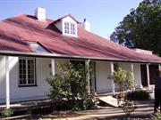
4260 Great Eastern Hwy Mahogany Creek
Mahogany Inn Hotel
Prince of Wales, Oxford Inn
Mundaring
Metropolitan
Constructed from 1854 to 1989
| Type | Status | Date | Documents |
|---|---|---|---|
| Heritage List | YES | 08 Mar 2016 | |
| State Register | Registered | 09 Sep 2003 | HCWebsite.Listing+ListingDocument, HCWebsite.Listing+ListingDocument |
| Type | Status | Date | Documents |
|---|---|---|---|
| (no listings) |
| Type | Status | Date | Grading/Management | |
|---|---|---|---|---|
| Category | ||||
| Statewide Hotel Survey | Completed | 01 Nov 1997 | ||
| Classified by the National Trust | Classified | 11 Jun 1973 | ||
| Register of the National Estate | Permanent | 21 Mar 1978 | ||
| Municipal Inventory | Adopted | 22 Apr 1997 | 1 - Exceptional significance | |
| Library Id | Title | Medium | Year Of Publication |
|---|---|---|---|
| 9507 | Mahogany Inn, Mahogany Creek, Western Australia: conservation works final report 2009. | Conservation works report | 2009 |
| 7741 | Mahogany Inn conservation works: final report. | Conservation works report | 2006 |
| 7263 | Mahogany Inn, Mahogany Creek : conservation plan. | Heritage Study {Cons'n Plan} | 2005 |
Individual Building or Group
| Epoch | General | Specific |
|---|---|---|
| Original Use | MILITARY | Barracks |
| Present Use | COMMERCIAL | Hotel, Tavern or Inn |
| Other Use | COMMERCIAL | Hotel, Tavern or Inn |
| Style |
|---|
| Victorian Georgian |
| Type | General | Specific |
|---|---|---|
| Roof | METAL | Corrugated Iron |
| Roof | TIMBER | Shingle |
| Wall | BRICK | Rendered Brick |
| Wall | STONE | Local Stone |
| Wall | RENDER | Other Render |
| General | Specific |
|---|---|
| OUTSIDE INFLUENCES | World Wars & other wars |
This information is provided voluntarily as a public service. The information provided is made available in good faith and is derived from sources believed to be reliable and accurate. However, the information is provided solely on the basis that readers will be responsible for making their own assessment of the matters discussed herein and are advised to verify all relevant representations, statements and information.
It is the oldest standing inn on the road to York and is probably the-oldest inn in the St ate which is still habitable. In 1884 Sir S.H. Parker bought the inn and later gave it to his daughter, Mrs Craven Smith Milne as a wedding present. The building represents one of the oldest standing inns in the State. Of particular interest are the two attic rooms and the cellar under the rooms which formed the original section built as Army barracks. Although there has been some recent restoration the building still appears to be faithful to the original concept. Furnished with pieces from early days•. Other items of interest such as personal possessions of pioneers of the district and collection of colonial implements and utensils, many of which have a history of their own•.
Stone and brick construct ion with a shingle roof now covered with iron. 11 rooms plus a hall, cellar and verandahs.
Assessment 1973 Construction: 1839 Oldest part of building was a Military Depot in about 1839.This building was included in a Crown grant of 320 acres to the Habgood brothers in 1841 when the Military were withdrawn. In 1844/5 the building was leased to and later bought by Edward J. H. Byfield who opened it as a roadside inn. Byfield later added to the original building, incorporating it into the larger building which exists today. Dat e of this extension is thought to have been about 1847/48. Architect: The oldest part of the building; was, no doubt, designed and built by the military themselves. Byfield himself built the extensions which he added as he was a carpenter by trade and it is most likely that he was his own architect.
This information is provided voluntarily as a public service. The information provided is made available in good faith and is derived from sources believed to be reliable and accurate. However, the information is provided solely on the basis that readers will be responsible for making their own assessment of the matters discussed herein and are advised to verify all relevant representations, statements and information.
Constructed from 1854, Constructed from 1898
The Old Mahogany Inn has very high aesthetic, social and historic significance for the Shire of Mundaring and the State. The location and setting have identifiable landmark qualities which add to its aesthetic significance. The role the inn has played, along the route leading to the early agricultural and development areas of the State, has important social and historic significance together with high authenticity and representativeness of the place. Associations with local identities such as the Byfields, and important State figures of the day, such as the Chief Justice S.H. Parker, further adds to the significance of the place.
The Mahogany Inn sits on the south side of the Great Eastern Highway in spacious, simply laid out gardens. Some of the large trees on the site feature in early paintings and photographs of the property and therefore add to its setting and probably its significance. The original barracks, and later the inn, are still visible and identifiable from the front of the property. The building's Colonial Georgian character is reflected in the low, red painted corrugated iron, hipped roof and the 'whitewashed' rendered stone walls with narrow, vertical windows. Across the front the long veranda (supported on backward leaning timber columns) terminates at each end against parapet walls on the leanto wings down the sides of the old inn. All the recent buildings have been incorporated at the rear so that on the whole the appearance of the front of the building is much as it has been for over a hundred and fifty years. The new buildings provide restaurant, function and reception room facilities catering for up to 120 guests attached across the rear of the original building and twelve accommodation units further up the sloping site to the east. Whilst the additions are of unmistakably recent origins, they do confuse the transition internally between the old and new elements. More clearly defined separation would identity the significance of the original fabric. The additions were well intentioned for their time (in the 1970's) in trying to create "old world charm"; however, today they have the urbane, white render and heavy timber appearance of'Spanish' and 'Swiss' style project housing of the period. The dark interiors of the new reception and function rooms are decorated with a collection of early farming implements and lifestyle artifacts that provide useful interpretive information but not in any apparent specific context. The old Mahogany Inn building itself is in sound but susceptible condition and construction of the new reception facilities has taken away the pressure of constant use. This has added considerably to the survival of the original fabric which is largely intact. The original rooms on the ground floor are now only used for small private functions in either the dining room or bar. The low, leanto eastern wing, is set up for display and viewing with old furniture and artifacts of earlier periods. Upstairs the two attic rooms are closed from public access because of their deteriorating condition particularly to the very low ceilings and walls of wattle or tea tree lathing with mud/horse hair plaster. Previously these rooms were also available for viewing and old furniture and memorabilia is still in place.
The first permanent building to be established at the site known as Mahogany Inn, was a granite barracks, with separate kitchen and store, to house patrols for the protection of travellers on the Guildford to York road. The site was also convenient to a road which branched off to Northam. Established in 1839, the Mahogany Creek Barracks were abandoned in September 1841, and in November 1842, Perth merchants William and Robert Habgood purchased 320 acres (100 ha) of land surrounding the former barracks, setting up a "Road-side House".
Integrity: high - although the additions at the rear obscure the original fabric which is still largely intact. Modifications: Various alterations and additions including recent reception and accommodation units.
Good
| Ref ID No | Ref Name | Ref Source | Ref Date |
|---|---|---|---|
| MHHS files "Mahogany Creek", "Old York Road". | |||
| ct Stannage; "The People of Perth". pp. 222-224 | PCC Perth | 1979 | |
| HW Baker; "The Early Days of Mahogany Creek". | |||
| n & W Conway; "The Old Mahogany Inn Museum & Tearooms". | |||
| I Elliot; ibid. pp 22-26, 29-36, 39-41, 44-45, 148-152, 245. |
This information is provided voluntarily as a public service. The information provided is made available in good faith and is derived from sources believed to be reliable and accurate. However, the information is provided solely on the basis that readers will be responsible for making their own assessment of the matters discussed herein and are advised to verify all relevant representations, statements and information.
Mundaring
P25251 Goldfields Water Supply Scheme is part of this place and is on the National Heritage List. Starts in Mundaring, at Mundaring Weir and travels through the Shires of Mundaring, Northam, Cunderdin, Tammin, Kellerberrin, Merredin, Westonia, Yilgarn, Coolgardie and Kalgoorlie-Boulder.
Golden Pipeline
Mundaring
Metropolitan
Constructed from 1898
| Type | Status | Date | Documents |
|---|---|---|---|
| State Register | Registered | 08 Dec 2022 | HCWebsite.Listing+ListingDocument, HCWebsite.Listing+ListingDocument |
| Type | Status | Date | Documents |
|---|---|---|---|
| (no listings) |
| Type | Status | Date | Grading/Management | |
|---|---|---|---|---|
| Category | ||||
| (no listings) | ||||
25251 Goldfields Water Supply Scheme (NHL)
• The place is an excellent example of an initiative by the Western Australian Government to provide water to the Goldfields at the turn of the century.
• The place is rare as one of the largest pipelines in Western Australia, possibly the largest that supplies water.
• The place has aesthetic value as a landmark feature extending from Mundaring to Kalgoorlie.
• The place is rare and has scientific value as an innovative engineering design and construction method of a pipeline from the early 20th Century.
• The place is rare as a long-distance water pipeline in Australia built in the early 1900’s.
The Goldfields Water Supply Scheme, demonstrates exceptional technical achievement as one of the longest overland pipeline schemes attempted in the nineteenth century, both in Australia and the world, and was recognised as an outstanding engineering achievement; The has exceptional value in demonstrating the historical importance of the provision of water to settlements along the route from Mundaring to the Eastern Goldfields, The construction and operation of the Pipeline had considerable importance in contributing to the sense of place for the people of Western Australia, and visitors to the State, as a highly valued tourist destination, the educational, cultural and aesthetic aspects of which are appreciated by history and engineering enthusiasts and teachers to this day; Individual elements of the place, including the existing interpretation associated with the Golden Pipeline Heritage Trail, museums, archaeological sites and remaining buildings and infrastructure, collectively have exceptional potential to communicate the history of the Goldfields Water Supply Scheme and its importance to Western Australia; The place is associated with a number of notable figures in Western Australian history, including the Scheme's designer CY O'Connor, State and Federal politician Lord John Forrest, the Director of the Public Works Department HW Venn and former Superintendent of Public Works, architect George Temple Poole, who each contributed to the successful completion of the Goldfields Water Supply Scheme; and The place is an exceptional example of applied science, technical excellence and innovative design, reflecting the ongoing ingenuity and innovation demonstrated by the talented and committed engineers employed by the Goldfields Water Supply Branch, Public Works Department and other iterations of the Water Corporation in the provision of water in the State. The longevity of the scheme is associated with innovators Mephan Ferguson, James Couston, engineers Norman Fernie and Reg Keating, and James Mathers.
The Goldfields Water Supply Scheme extends in a discontiguous precinct across the 560km linear water pipeline, commencing at Mundaring Weir (1902, 1951) in the Helena Valley and terminating at Mount Charlotte Reservoir (1902) in Kalgoorlie-Boulder. Comprising six extant original Steam Pump Stations (1902) at Mundaring, Cunderdin, Merredin, Yerbillon, Ghooli and Dedari; the sites of two demolished Steam Pump Stations (1902) at O’Connor and Gilgai; Reservoirs and Tanks at O’Connor, Sawyers Valley, Bakers Hill, West Northam, Cunderdin, Merredin, Yerbillon, Ghooli, Bronti, Gilgai, Koorawawalyee, Dedari, Toorak, and Bullabulling; second generation Electric Pump Station at Merredin , and other community sites, ancillary structures; equipment and machinery, archaeological sites; and discontiguous portions of the main pipeline conduit associated with the construction and operation of the Scheme from 1902 to the present.
Phase I - Construction of the Goldfields Water Supply Scheme (1898 - 1903) Phase II – Problem Solving and Agricultural Expansion (1904 - 1940) Phase III – Comprehensive Water Supply Scheme, Upgrades & Refurbishments (1946 - 2013) Phase IV - Heritage Recognition and The Golden Pipeline (1992 - 2011)
High
Good
| Name | Type | Year From | Year To |
|---|---|---|---|
| Charles Yelverton O'Connor | Architect | 1898 | 1902 |
| Library Id | Title | Medium | Year Of Publication |
|---|---|---|---|
| 6452 | Mundaring Weir Precinct masterplan : final master plan report. | Heritage Study {Other} | 2002 |
| 7358 | Conservation plan for Goldfields Water Supply Scheme. Volume II, place M : No. 8 Pumping Station, Dedari. | Heritage Study {Cons'n Plan} | 1999 |
| 11426 | Goldfields Water Supply Volume III | Heritage Study {Cons'n Plan} | 1999 |
| 4897 | Conservation plan for Karalee Rock Water Catchment (Goldfields Water Supply Scheme - place J). | Heritage Study {Cons'n Plan} | 2000 |
| 7359 | Conservation plan for Goldfields Water Supply Scheme. Volume II, place N : Bullabulling reservoir. | Heritage Study {Cons'n Plan} | 1999 |
| 9248 | Constructing Australia: Triumphs and tragedies in building a nation. | C D Rom | 2007 |
| 6390 | Pipe-dream to pipeline : the eventful life of Nathaniel W. Harper. | Book | 2001 |
| 3680 | Conservation plan for No. 3 Pumping Station, Cunderdin. | Heritage Study {Cons'n Plan} | 1998 |
| 1774 | An exploratory bibliography of the Goldfields Water Supply of Western Australia (draft). | Report | 1982 |
| 4504 | Conservation plan for Mount Charlotte Reservoir (Goldfields water supply scheme - place O). | Heritage Study {Cons'n Plan} | 2000 |
| 11762 | Goldfields Water Supply Scheme, Main conduit, Western Australia | Heritage Study {Cons'n Plan} | 2016 |
| 6788 | Conservation plan for Koorarawalyee water catchment and railway station (Draft) (Goldfields Water Supply Scheme - place U). | Heritage Study {Cons'n Plan} | 2001 |
| 9806 | Mundaring Weir water Supply interpretation precinct design. | Book | 2010 |
| 7350 | Conservation plan for West Northam regulating tanks : (Goldfields Water Supply Scheme - place T) (draft). | Heritage Study {Cons'n Plan} | 2001 |
| 7356 | Conservation plan for Goldfields Water Supply Scheme. Volume II, place I : No. 6 Pumping Station, Ghooli. | Heritage Study {Cons'n Plan} | 1999 |
| 7547 | Celebrating 100 years of the Goldfields Water Supply Scheme. | Brochure | 2003 |
| 7354 | Conservation plan for Goldfields Water Supply Scheme. Volume II, place G : No. 4 Pumping Station, Merredin. | Heritage Study {Cons'n Plan} | 1999 |
| 7351 | Conservation plan for Toorak Hill reservoir : (Goldfields Water Supply Scheme - place V) (draft). | Heritage Study {Cons'n Plan} | 2001 |
| 7352 | Conservation plan for Goldfields Water Supply Scheme. Volume II, place A : No. 1 Pumping Station Mundaring. | Heritage Study {Cons'n Plan} | 1999 |
| 7348 | Conservation plan for Sawyers Valley summit tanks : (Goldfields Water Supply Scheme - place R) (draft). | Heritage Study {Cons'n Plan} | 2001 |
| 6675 | Mundaring Weir : conservation plan (draft). | Heritage Study {Cons'n Plan} | 2000 |
| 1608 | Conservation and interpretation plan for No.1 Pumping Station Mundaring. | Heritage Study {Cons'n Plan} | 1996 |
| 5988 | Centenary of the Goldfields Water Supply Scheme 1903-2003. | Brochure | 2003 |
| 7444 | The agricultural areas, Great Southern towns and Goldfields Water Supply Scheme : souvenir to commemorate the completion of the project. | Book | 1961 |
| 10170 | The origins of the Eastern Goldfields water scheme in Western Australia: an exercise in the interpretation of historical evidence. | Book | 1954 |
| 4644 | Conservation plan for Goldfields Water Supply Scheme : volume 1. | Heritage Study {Cons'n Plan} | 1999 |
| 7357 | Conservation plan for Goldfields Water Supply Scheme. Volume II, place K : No. 7 Pumping Station, Gilgai. | Heritage Study {Cons'n Plan} | 1999 |
| 8902 | River of steel. A history of the Western Australian Goldfields and Agricultural Water Supply 1903 - 2003. | Book | 2007 |
| 7355 | Conservation plan for Goldfields Water Supply Scheme. Volume II, place H : No. 5 Pumping Station, Yerbillon. | Heritage Study {Cons'n Plan} | 1999 |
| 7353 | Conservation plan for Goldfields Water Supply Scheme. Volume II, place B : No. 2 Pumping Station, O'Connor. | Heritage Study {Cons'n Plan} | 1999 |
| 7349 | Conservation plan for Bakers Hill regulating tank : (Goldfields Water Supply Scheme - place S) (draft). | Heritage Study {Cons'n Plan} | 2001 |
| 6794 | Conservation plan for Bullabulling township and railway catchment. (draft) : a supplement to the Bullabulling Reservoir conservation plan (Goldfields Water Supply Scheme - place N). | Heritage Study {Cons'n Plan} | 2001 |
| 9899 | Mundaring Weir water supply improvement project: heritage management strategy. | Heritage Study {Other} | 2011 |
| 6326 | The golden pipeline heritage trail guide : a time capsule of water, gold and Western Australia. | Book | 2002 |
| 4693 | Goldfields Water Supply heritage project. | Book | 1999 |
| 5544 | Golden Pipeline interpretation plan. | Heritage Study {Other} | 2001 |
Other Built Type
| Epoch | General | Specific |
|---|---|---|
| Original Use | GOVERNMENTAL | Power Station |
| Present Use | GOVERNMENTAL | Pumping Station |
| Present Use | EDUCATIONAL | Museum |
| Style |
|---|
| Vernacular |
| Type | General | Specific |
|---|---|---|
| Wall | BRICK | Common Brick |
| Wall | METAL | Steel |
| Roof | METAL | Corrugated Iron |
| General | Specific |
|---|---|
| SOCIAL & CIVIC ACTIVITIES | Community services & utilities |
| DEMOGRAPHIC SETTLEMENT & MOBILITY | Technology & technological change |
| DEMOGRAPHIC SETTLEMENT & MOBILITY | Resource exploitation & depletion |
| DEMOGRAPHIC SETTLEMENT & MOBILITY | Exploration & surveying |
This information is provided voluntarily as a public service. The information provided is made available in good faith and is derived from sources believed to be reliable and accurate. However, the information is provided solely on the basis that readers will be responsible for making their own assessment of the matters discussed herein and are advised to verify all relevant representations, statements and information.
Lot 502 Hall Rd Mundaring
Cnr Weir Village & Hall Rds; to be included in P8538 Mundaring Weir Precinct
Goldfields Reservoir Hotel
Weir Lodge Hotel
Mundaring
Metropolitan
Constructed from 1898 to 1999
| Type | Status | Date | Documents |
|---|---|---|---|
| Heritage List | YES | 08 Mar 2016 | |
| State Register | Registered | 20 Apr 2004 | HCWebsite.Listing+ListingDocument, HCWebsite.Listing+ListingDocument |
| Type | Status | Date | Documents |
|---|---|---|---|
| (no listings) |
| Type | Status | Date | Grading/Management | |
|---|---|---|---|---|
| Category | ||||
| Municipal Inventory | Adopted | 22 Apr 1997 | 1 - Exceptional significance | |
| Aboriginal Heritage Sites Register | Permanent | |||
| Classified by the National Trust | Classified | 10 Feb 2003 | ||
| Statewide Hotel Survey | Completed | 01 Nov 1997 | ||
08538 Mundaring Weir, Gardens and Village Precinct
| Name | Type | Year From | Year To |
|---|---|---|---|
| Jacoby Bros. | Architect | - | - |
| Library Id | Title | Medium | Year Of Publication |
|---|---|---|---|
| 7463 | Conservation plan for Mundaring Weir Hotel, Mundaring Weir. | Heritage Study {Cons'n Plan} | 2005 |
| 9485 | Mundaring Weir Hotel conservation works: final conservation work report. | Conservation works report | 2009 |
| 6452 | Mundaring Weir Precinct masterplan : final master plan report. | Heritage Study {Other} | 2002 |
Individual Building or Group
| Epoch | General | Specific |
|---|---|---|
| Present Use | COMMERCIAL | Hotel, Tavern or Inn |
| Original Use | COMMERCIAL | Hotel, Tavern or Inn |
| Style |
|---|
| Federation Filigree |
| Type | General | Specific |
|---|---|---|
| Wall | BRICK | Common Brick |
| Roof | METAL | Corrugated Iron |
| General | Specific |
|---|---|
| DEMOGRAPHIC SETTLEMENT & MOBILITY | Workers {incl. Aboriginal, convict} |
| PEOPLE | Famous & infamous people |
| TRANSPORT & COMMUNICATIONS | Mail services |
| OUTSIDE INFLUENCES | Tourism |
| OCCUPATIONS | Hospitality industry & tourism |
| DEMOGRAPHIC SETTLEMENT & MOBILITY | Settlements |
This information is provided voluntarily as a public service. The information provided is made available in good faith and is derived from sources believed to be reliable and accurate. However, the information is provided solely on the basis that readers will be responsible for making their own assessment of the matters discussed herein and are advised to verify all relevant representations, statements and information.
following reasons: the place contains part of the oldest surviving permanent building at Mundaring Weir which developed as a service centre for the Goldfields Water Supply Scheme; the place served as a popular tourist venue for the people of Perth for nearly 100 years and has become a popular cultural venue for local entertainers; the place has associations with C.YO'Connor, the engineer who designed the Goldfields Water Supply Scheme, David Helfgott, an internationally renowned pianist, Frank Pash and internationally acclaimed painter and the Goldfields Water Supply Scheme; the place has become a cultural venue which attracts residents who live locally, people from the wider Perth community and international visitors; and, the place is a good example of the Federation Filigree style and, together with the Mundaring Weir Hall forms a small historic precinct.
Mundaring Weir Hotel is composed of two distinct sections The earliest component is a single storey weatherboard and iron structure built in 1898. The later section is a two storey brick and iron structure, with a double storey verandah, built inc. 1906. The building is an example of Federation Filigree. The earlier section was built for Mathieson and Frederick Jacoby, while the later section was built for Frederick Jacoby. A comparatively small community lives at Mundaring Weir, which lies to the south of Mundaring. The villagers mainly home to support personnel for C.A.L.M., who are responsible for the state-forests surrounding the Mundaring weir and some private residents. Mundaring Weir Hotel is located on the corner of Weir Village Road (south eastern) and Hall Road. Several residences are located on the eastern side of Weir Village Road while on the north western side of Hall Road is the Mundaring Weir Hall. Both Mundaring Weir Hotel and the Mundaring Weir Hall are located close to the entrance of the public park at Mundaring Weir. The site slopes downwards on the southern and western sides The land on the western side of Mundaring Weir Hotel has been retained behind a rendered brick wall which runs parallel with Weir Village Road. This area has several mature trees planted along it, including a row of coral trees. The land at the rear of Mundaring Weir Hotel (western side) has been terraced to form an amphitheatre. Immediately to the west of the terracing is a flat piece of land which contains a pool and a grassed area. To the west of this is another flat area of land, before the site slopes down steeply to Portagabra Creek at the western edge of the site.
Assessment 2003 Construction 1898 Mundaring Weir Hotel was built by the Jacoby brothers, Matheison and Frederick Jacoby in 1898. At the time of the hotel's construction work has just commenced on the construction of the Goldfields Water Supply Scheme, with the construction of a dam on the Helena River in the Darling Ranges, the key component. The dam construction attracted a large work force and a camp was established 'on the southern' side of the Helena River to the west of the dam wall. The lack of legal supplies of alcohol were soon felt at the dam and the Jacoby brothers were successful in applying for a liquor license in 1898. The Goldfields Water Supply Scheme was officially opened in January 1903 and although the vast numbers of workmen soon left the site, a small community stayed on at the weir servicing the two pumping stations that were constructed to pump water out of the valley and on its way to Kalgoorlie. Frederick Jacoby enlarged the hotel by adding a two storey brick section to the front of the original weatherboard building in c.1906. The hotel prospered and became particularly popular during the first quarter of the twentieth century when large numbers of people came to visit the Weir. Patronage declined during the Depression years and it was not until the end of the twentieth century that the hotel again became a popular venue when concerts were staged in the outdoor amphitheatre at the rear of the hotel. David Helfgott gave his first concerts at the hotel in 1985, and once the film 'Shine- was released in 1995, the concerts "became particularly popular, leading to a more formalised arrangement to the amphitheatre.
This information is provided voluntarily as a public service. The information provided is made available in good faith and is derived from sources believed to be reliable and accurate. However, the information is provided solely on the basis that readers will be responsible for making their own assessment of the matters discussed herein and are advised to verify all relevant representations, statements and information.
Constructed from 1920, Constructed from 1897
16610 Goldfields Water Supply Scheme
The Mundaring Weir Hotel has very high social, historic and aesthetic significance, both locally and State, for its associations with the Weir's construction, operation and tourist activities together with its two storey architectural style of which there are only several examples in the Shire.
The approach and entry into the Hotel today is through the newer two storey brick additions carried out in the early 1900's; however, parts if the original 1898 single storey weatherbaord hotel are still visible on the west (rear) and south sides. The architectural style of the building falls into the broad Federation style category and, although restrained in it's decoration, has elements of Queen Anne and Arts and Crafts with it's timber verandah detailing. Brickwork to the "new" front section is plain red brick laid in English bond. The roof form, using corrugated iron, features rendered mouldings to a large chimney, gambrel ends on ridges and a rendered parapet across the front. The steeply sloping site drops away significantly tot he rear, allowing recent infill to provide cafe/bistro below what was the original single storey weatherboard section. new single storey brick accommodation units step further down the site to the rear. Internally the rear single storey, timber framed section, still accommodates it's original ballroom and dining room which feature richly detailed pressed metal ceilings, timber panelling and full height coloured glass folding doors to divide the large overall space into smaller function rooms if required, From a connecting hallway, between the old and "new" sections, a jarrah staircase, with stained glass windows on the half landing, leads to the first floor of the front brick section which now accommodates the manager's residence. The interiors of the front ground floor bars have been renovated over the years and retain little of their original detail; for example ceilings that are now plain plasterboard with coved cornices.
From 1903, when the weir first overflowed, the re-named 'Goldfields Weir Hotel', enjoyed patronage from sightseers as well as locals. Sometime in the period 1904-7, Fred Jacoby took over the running of the hotel, and added a two storey section to the front of the 1898 building. A postal agency operated here from c.1907. Also in 1907, he was able to open the bar on Sundays, and in 1909, when the Western Australian Government Railways took over the Weir line, the tourist trade increased rapidly. Aside from a short period during World War I when the Weir was off limits to civilians, excursion trains remained popular until the advent of World War II. As evidenced by advertisements in the "Motorist and Wheelman", the 1920's saw an increase in motor traffic coming to the hotel. The hotel was later run by Fred Jacoby's daughter, Elfreda Devenish. In the time since World War II, the hotel remained licensed and continued to be used as a post office agency. It gradually fell into poor condition until restoration work was begun in the mid 1970's by the late Kerry Burke and subsequent owners. Additions include the building in the early 1990's, of ten accommodation units and a swimming pool. In recent years, the Goldfields Weir Hotel has been the scene of classical and jazz music concerts, and other diverse social and cultural activities.
Integrity: high- Although the original single storey buildings are dominated by the later two storey brick buildings.
Good
| Ref ID No | Ref Name | Ref Source | Ref Date |
|---|---|---|---|
| "MHHS files 'Karda Mordo' & 'Mundaring Weir'." | |||
| Elliot; ibid pp. 139, 142 |
This information is provided voluntarily as a public service. The information provided is made available in good faith and is derived from sources believed to be reliable and accurate. However, the information is provided solely on the basis that readers will be responsible for making their own assessment of the matters discussed herein and are advised to verify all relevant representations, statements and information.
Jacoby St Mundaring
Includes: landscaped park containing 9 pieces of artwork, CWA Rest Room, rotunda, playground, amphitheatre, former station master's house and Scout Hall
Mundaring Community Park
Mundaring Railway Station & Railway Reserve
Mundaring
Metropolitan
Constructed from 1898 to 1996
| Type | Status | Date | Documents |
|---|---|---|---|
| Heritage List | YES | 08 Mar 2016 | |
| State Register | Registered | 28 Nov 2003 | HCWebsite.Listing+ListingDocument, HCWebsite.Listing+ListingDocument |
| Type | Status | Date | Documents |
|---|---|---|---|
| (no listings) |
| Type | Status | Date | Grading/Management | |
|---|---|---|---|---|
| Category | ||||
| Municipal Inventory | Adopted | 22 Apr 1997 | 1 - Exceptional significance | |
| Classified by the National Trust | Classified | 12 May 2003 | ||
| Name | Type | Year From | Year To |
|---|---|---|---|
| Jon Tarry & Peter Dailey | Architect | - | - |
| Hans Arkeveld & Stuart Elliot | Architect | - | - |
| Ross Donaldson, Phil Palmer, Trevor Woodward | Architect | - | - |
| Ronald Sims & Ron Gomboc | Architect | - | - |
| Nola Farnham & Alan Clark | Architect | - | - |
Historic site
| Epoch | General | Specific |
|---|---|---|
| Original Use | Transport\Communications | Rail: Railway Station |
| Present Use | PARK\RESERVE | Park\Reserve |
| Style |
|---|
| Victorian Georgian |
| Type | General | Specific |
|---|---|---|
| Other | BRICK | Common Brick |
| Other | METAL | Bronze |
| Wall | ASBESTOS | Fibrous Cement, flat |
| Other | CONCRETE | Reinforced Concrete |
| Other | TIMBER | Other Timber |
| Roof | METAL | Corrugated Iron |
| Other | METAL | Other Metal |
| Other | METAL | Steel |
| Other | STONE | Granite |
| General | Specific |
|---|---|
| TRANSPORT & COMMUNICATIONS | Rail & light rail transport |
| OUTSIDE INFLUENCES | Tourism |
| SOCIAL & CIVIC ACTIVITIES | Community services & utilities |
This information is provided voluntarily as a public service. The information provided is made available in good faith and is derived from sources believed to be reliable and accurate. However, the information is provided solely on the basis that readers will be responsible for making their own assessment of the matters discussed herein and are advised to verify all relevant representations, statements and information.
Constructed from 1898, Constructed from 1995
The Mundaring Sculpture Park has very high aesthetic, social and historic significance for the State and the Shire of Mundaring for its unique arts concept, associations with prominent Local, State and Nationally recognised artists; and with the history of the railways.
The Mundaring Sculpture Park is located among the trees on the railway reserve at the southern boundary of the town centre. Numerous sculptures from prominent State and local artists are strategically placed throughout the reserve in the naturally landscaped park setting complimented by a performance ampitheatre space centred on the old railway line itself is now part of a continuous walk/bridle trail throughout the Shire and forms a linear axis for the Sculpture park.
The linear sculpture park, which occupies a small section along the route of the original Eastrn Railway Reserve in Mundaring, is an ongoing project which was officially opened as part of the Bicentennial celebrations on 11th September 1988. The main conceptual design for the park arose from a report prepared in 1984, for the Mundaring park Committee, by architct Ross Donaldson and landscape architect Phil Palmer, with the assistance of artist Trevor Woodward. The Committee, now headed by Ross Donaldson, included various Community Arts Officers, members of the Mundaring Arts Board, Shire of Mundaring, Mundaring Ratepayers Associaition and Andra Kins, who later became the Executive Director of the Crafts Council WA. Initially the artists represented in the park were Hans Arkeveld, Ron Gomboc, Richard Fry, Peter Dailey, Jon Tarry and Stuart Elliot, whose vandalised tourist figures were restored on site in June 1990. In 1989, on the embankment opposite the former Mundaring Railway Platform, work began on the ampitheatre. Nearby, a signal sculture acknowledging the site's railway heritage and designed by Alan Clark, was opened in 1990. Since then, two sound sculptures, one by Ron Sims (1992) and one by Nola Farman (1995) have been added to the park. Since it's opening in late 1988, the park has gained Australia wide recognition for it's community arts focus. The importance of the sculptures has been recognised in the renaming of the park to Mundaring Sculpture Park.
Integrity: Very High
Very Good
| Name | Type | Year From | Year To |
|---|---|---|---|
| Phil Palmer | Architect | - | - |
| Ross Donaldson | Architect | - | - |
| Trevor Woodward | Architect | - | - |
| Andra Kins | Architect | - | - |
| Ref ID No | Ref Name | Ref Source | Ref Date |
|---|---|---|---|
| Echo; "A Day in the park".p.12 | 28/8/1988 | ||
| Echo; :"A Seat in the park". | 17/7/1988 | ||
| 'Take a fresh look-they're unreal'. p.34 | West Australian | 8/9/1988 | |
| I Elliot; ibid p. 117 | |||
| Donaldson Smith Architects & Urban Designers; 'Mundaring Park: the Art of Good Community'. | 1984 | ||
| 'Art for the people' West Australian". p.viii | West Australian | 10/9/1988 | |
| Echo; "Vandals: a personal attack". p.1 | 30/9/1988 | ||
| Echo; "Unique park". p.3 | 4/9/1988 |
| Owner | Category |
|---|---|
| Shire of Mundaring | Local Gov't |
This information is provided voluntarily as a public service. The information provided is made available in good faith and is derived from sources believed to be reliable and accurate. However, the information is provided solely on the basis that readers will be responsible for making their own assessment of the matters discussed herein and are advised to verify all relevant representations, statements and information.
Mundaring Sculpture Park, a landscaped park containing several pieces of artwork, a CWA Rest Room, playground, Amphitheatre, former station master's house and Scout Hall, all contained within what was formerly a railway station reserve, has cultural heritage significance for the following reasons: . the place is the only community sculpture park in Western Australia; . the Earth Sound Device, an audio installation by artist Nola Farnham, is recognised nationally as an innovative piece of artwork; . the place successfully combines natural landscaping with built elements and sculpted pieces to create a fully integrated cultural precinct; . the place has become a popular venue for local festivals and other cultural events and is held in high esteem by the local community; and, . the place has retained physical reminders of the site's railway heritage, such as the former Station Master's House, the former Mundaring station platform and the former railway formation, all of which were important to the development of Mundaring
Mundaring Sculpture Park is located at the southern end of Nichol Street on the edge of the central business district of Mundaring. The site is bounded by Jacoby Street to the north, Maddock Street to the east, Phillips Road to the south and Gugeri Street to the west. Nichol Street bisects Jacoby Street approximately halfway along the length of the park. The southern side of the park is bounded by a residential area, while the eastern and western sides represent the continuation of the Railway Heritage Trail. The route of the former railway line bisects the site east - west and there are secondary paths which run through the site approximately north - south. A prominent feature of the park are the numerous mature trees on the northern and southern side of the park (at the eastern end). These trees include pines, plane trees and a variety of eucalypts. Numerous, younger trees are clustered randomly along the northern and southern edges of the former railway line and some have also been planted down the centre of the former line, at the eastern end, creating two distinct paths. A central lawned area lies opposite the terminus of Nichol Street. The area directly opposite the southern end of Nichol Street is a cleared open space with a backdrop of mature eucalypts and native plants. On the southern side of this area are four large, roughly squared logs which bear the name of the park 'Mundaring Community Sculpture Park. Just to the west of these logs is an exit point for one of the north- south pathways. The former Mundaring Station Master's House lies on the western side of the cleared area. The amphitheatre and former railway platform lie to the west of the lawned area and south of the former Mundaring Station Master's House. The Scout Hall is located on Nichol Street to the west of the former Mundaring Station Master's House. The rotunda is to the south west of the Scout Hall amongst young saplings and native plants. The CWA building is located at the eastern end of the park, while the sculptures are spread along the paths at the eastern end of the park and near the amphitheatre. The sculptural pieces are: Mother (Jon Tarry), Tractor (Peter Dailey), Moondae Ring (Ronald Sims), Missed Last Train (Ron Gomboc), Mainstream (Hans Arkveld), Tourists (Stuart Elliot), Second Wave (Alan dark) and Earth Sound Device (Nola Farnham).
Assessment 2003 Construction 1902 - 1996 Mundaring Sculpture Park comprises the former Mundaring Station platform (1898), the former Mundaring Station Master's House (1902), the Mundaring CWA Hall (1954), the Mundaring Scout Hall (1960s), several pieces of public sculpture (1988 - 1995), a rotunda (1993), landscaped grounds (1988 & 1991) and a children's playground (1960s - 996). These elements are all located on a section of the Railways Heritage Trail (1988). The Park was officially opened on 11 September 1988 as part of the Commonwealth Bicentennial celebrations. The development of the Park was organised by a community based committee which consulted regularly with the local community. Many of the artists lived locally and gave their time freely to the project, while local businesses donated materials. 2 Mundaring Sculpture Park was placed on the Shire ofMundaring's Municipal Inventory in 1997. In April 2003, the Park is heavily used by local community groups for various activities and there are proposals in place for the commissioning of additional sculptural pieces.
This information is provided voluntarily as a public service. The information provided is made available in good faith and is derived from sources believed to be reliable and accurate. However, the information is provided solely on the basis that readers will be responsible for making their own assessment of the matters discussed herein and are advised to verify all relevant representations, statements and information.
Jacoby St Mundaring
Mundaring Station-master's House
Mundaring
Metropolitan
Constructed from 1902
| Type | Status | Date | Documents |
|---|---|---|---|
| (no listings) |
| Type | Status | Date | Documents |
|---|---|---|---|
| (no listings) |
| Type | Status | Date | Grading/Management | |
|---|---|---|---|---|
| Category | ||||
| Municipal Inventory | Adopted | 22 Apr 1997 | 3 - Moderate significance | |
08577 Mundaring Sculpture Park
The former Station Master's House is in poor condition (2003) although repairs to the roof have ensured that the interior is now protected from further water damage through the roof.
| Library Id | Title | Medium | Year Of Publication |
|---|---|---|---|
| 5167 | Station Master's House (former), Mundaring : conservation plan / prepared for Shire of Mundaring by Laura Gray in association with Philippa Rogers. | Heritage Study {Cons'n Plan} | 2001 |
| 5971 | Mundaring Stationmaster's House, Stage 1 conservation works : final report. | Conservation works report | 2002 |
Individual Building or Group
| Epoch | General | Specific |
|---|---|---|
| Present Use | RESIDENTIAL | Single storey residence |
| Original Use | Transport\Communications | Rail: Housing or Quarters |
| Type | General | Specific |
|---|---|---|
| Roof | METAL | Corrugated Iron |
| Wall | BRICK | Common Brick |
| General | Specific |
|---|---|
| TRANSPORT & COMMUNICATIONS | Rail & light rail transport |
This information is provided voluntarily as a public service. The information provided is made available in good faith and is derived from sources believed to be reliable and accurate. However, the information is provided solely on the basis that readers will be responsible for making their own assessment of the matters discussed herein and are advised to verify all relevant representations, statements and information.
Constructed from 1902
The Mundaring Station-master's house has high social and historic significance as one of the few railway fragments remaining intact and as a reminder of the importance of the railways to the development of the region and the impact it had on the community lifestyle.
The Mundaring station-master's house is diagonally opposite the Mundaring Hotel in Jacoby Street and side on to the street and railway reserve which is now the site of the Mundaring sculpture park (Site 269). The house is near the original station platform which has been adapted as a stage for the park's amphitheatre. It is a simple brick residence, typical of the standard government pattern of the period, with central hall, rooms off either side and rear leanto providing bathroom, laundry etc. The hipped corrugated iron roof extends down lower across the front (east) to form a full width veranda.
When the townsite of Mundaring was gazetted in May 1898, one of the earliest buildings constructed was the railway station. The brick and iron station-master's house was built some time later, and is one of the few remaining railway residences in the shire. The others are a weatherboard and iron house at Glen Forrest (Site 102), and what is thought to be the former station-master's residence at Wooroloo.
Integrity: HIgh
Good
| Ref ID No | Ref Name | Ref Source | Ref Date |
|---|---|---|---|
| I Elliot; ibid. pp 116, 117 |
This information is provided voluntarily as a public service. The information provided is made available in good faith and is derived from sources believed to be reliable and accurate. However, the information is provided solely on the basis that readers will be responsible for making their own assessment of the matters discussed herein and are advised to verify all relevant representations, statements and information.
2075 Jacoby St Mundaring
Ballindown
Mundaring
Metropolitan
Constructed from 1911, Constructed from 1914
| Type | Status | Date | Documents |
|---|---|---|---|
| Heritage List | YES | 08 Mar 2016 | |
| State Register | Registered | 07 Sep 2007 | HCWebsite.Listing+ListingDocument, HCWebsite.Listing+ListingDocument |
| Type | Status | Date | Documents |
|---|---|---|---|
| (no listings) |
| Type | Status | Date | Grading/Management | |
|---|---|---|---|---|
| Category | ||||
| Municipal Inventory | Adopted | 22 Apr 1997 | 1 - Exceptional significance | |
| Classified by the National Trust | Classified | 01 May 1995 | ||
Faversham’s main residence and the three detached cottages are currently in good condition and being well maintained. The problem of water damage to the ceiling in the kitchen is presently being addressed by the owners. The main residence and the three cottages are well maintained. Both the loft/garage and stable block are in fair to good condition, although the maintenance program has not been as vigorous. The tank stand appears to be in good condition. No maintenance has been carried out.
| Library Id | Title | Medium | Year Of Publication |
|---|---|---|---|
| 7022 | Images CD No. 26 : assessment images : Mundaring Hotel, Temuka, Faversham, Armadale Brickworks (fmr). | C D Rom | 2004 |
Individual Building or Group
| Epoch | General | Specific |
|---|---|---|
| Other Use | RESIDENTIAL | Conjoined residence |
| Present Use | RESIDENTIAL | Single storey residence |
| Other Use | RESIDENTIAL | Institutional Housing |
| Original Use | RESIDENTIAL | Single storey residence |
| Style |
|---|
| Federation Queen Anne |
| Type | General | Specific |
|---|---|---|
| Wall | TIMBER | Weatherboard |
| Wall | STONE | Laterite |
| Roof | METAL | Corrugated Iron |
| General | Specific |
|---|---|
| SOCIAL & CIVIC ACTIVITIES | Community services & utilities |
| OCCUPATIONS | Hospitality industry & tourism |
| OCCUPATIONS | Domestic activities |
| DEMOGRAPHIC SETTLEMENT & MOBILITY | Land allocation & subdivision |
This information is provided voluntarily as a public service. The information provided is made available in good faith and is derived from sources believed to be reliable and accurate. However, the information is provided solely on the basis that readers will be responsible for making their own assessment of the matters discussed herein and are advised to verify all relevant representations, statements and information.
Constructed from 1913
"Ballindown /Faversham" has very high social and historic significance for: • its associations with a prominent local and State recognised person in Alexander McCallum; • as a reminder of how the hills developed as a holiday destination for the wealthy; • as an example of a hills retreat built for the wealthy at the turn of the century and of which there are few remaining examples with such integrity (scarcity value); • as one of the most significant private houses built in Mundaring especially at that time; • and as an example of the adaptive use of large residences as convalescent homes which were formerly an important part of post hospital care; and more recently for bed and breakfast accommodation.
"Ballindown" sits among large trees and landscaped gardens of Jacoby Street in the western outskirts of the Mundaring townsite. Building son the site include the main residence, servants quarters, stables and loft. A former head gardener's cottage, now a separate property was also built on the northern side of the 5 acre property fronting Great Eastern highway. The main residence is a large rambling house using an eclectic but unified combination of materials and 'federation' styling. A large hipped corrugated iron/zincalume roof encompasses the main residence with it's surrounding wide, timber floor boarded verandahs. The walls of the house are local laterite stone on the western half and weatherboard on the east. Whether this is indicative of the house being built on stages has not yet been determined. French doors open out onto the verandahs and the entry door and sidelights have leadlight stained glass with a floral motif which is also carried through onto other windows and doors. The entry leads to central hall which has a coloured glass roof light ceiling. Off the entry tot he east is a large living/dining room in the weatherboard section of the house. It has decorative lath plaster vaulted ceilings with ribbed mouldings and ceiling roses. Detailing throughout the house is of a consistently high standard with moulded timber skirtings, architraves and Art Nouveau door furniture. The servants quarters tot e rear of the main residence are of matching style with stone walls and brick quoins but instead of verandahs there are decorative timber window canopies and entry porches. The quarters have now been converted to a bed and breakfast type accommodation. The stables, barn and loft are separated somewhat tot he north-east of the residence and are of weatherboard and corrugated iron construction.
Coach-builder and ironmonger Alexander McCallum, who came here from South Australia in 1895, built "Ballindown" at Mundaring as a weekender for himself and wife Rosa. At the same time, they retained a house in Beach Street, Cottesloe. Title deed information indicates that the 8-acre lot on which "Ballindown" was built was first purchased by George Rae in 1911, and sold later that year to Rosa McCallum. In 1913, the McCallums purchased Lot 65 on the eastern side of their property, and it is likely that the house dates from about this time. Although the McCallums used "Ballindown" as a weekender and were away overseas every winter, they still actively participated in the local community. Alex McCallum was patron of many sporting teams, including the local cricket club. They were benefactors of the 1914 Anglican Church of the Epiphany (Site 48), and it has been suggested that the stonemasons employed by McCallum to build parts of his house were responsible for the church. As well as being the first person in Mundaring with a motor car and a home lighting plant, McCallum was an Administrator of the World War I Trench Comforts Fund. To the delight of local children, he was also the annual "Father Christmas". During their time at Ballindown, the McCallums also added a billiard room, servant's quarters and close to the York Road (Great Eastern Highway), a gardener's cottage (Site 24). McCallum's gardener, Mr. Atkinson, a local orchardist, supervised the property in their absence and is reputed to have looked after his employer's donated roses at the Mundaring War Memorial (Site 42). In 1941, when McCallum died, Rosa sold the property, and in 1948, it was purchased by the Monger sisters from York who re-named it "Faversham", after their family's home. After making some alterations to the veranda and billiard room, Ethel, Norma and Eileen Monger operated "Faversham" as a convalescent home for short stay patients who had been discharged from hospital. In c. 1968, when the Lenegens purchased "Faversham" they continued the convalescent home. In 1970, the Wilkinson-Cox family re-named the property "Ballindown" and restored the house as a family home and altered the outbuildings. When the Wiltshires purchased the property in June 1993, they re-used the name "Faversham" At present "Faversham" is a family home, with overnight guest accommodation.
Integrity: Very High Modifications: Verandahs added 1948 and various internal modifications over the years.
Very Good
| Ref ID No | Ref Name | Ref Source | Ref Date |
|---|---|---|---|
| I Elliot; ibid pp. 123-124 | |||
| MHHS File; "Mundaring". | |||
| F Bush; " National Trust Assessment of Faversham" | National Trust of Australia (WA) | Feb 1995 |
This information is provided voluntarily as a public service. The information provided is made available in good faith and is derived from sources believed to be reliable and accurate. However, the information is provided solely on the basis that readers will be responsible for making their own assessment of the matters discussed herein and are advised to verify all relevant representations, statements and information.
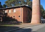
Mundaring Weir Rd Mundaring Weir
to be included in P8538 Mundaring Weir Precinct assessment
CY O'Connor Museum
Mundaring
Metropolitan
Constructed from 1902
| Type | Status | Date | Documents |
|---|---|---|---|
| Heritage List | YES | 08 Mar 2016 | |
| State Register | Registered | 04 May 2001 | HCWebsite.Listing+ListingDocument, HCWebsite.Listing+ListingDocument |
| Type | Status | Date | Documents |
|---|---|---|---|
| (no listings) |
| Type | Status | Date | Grading/Management | |
|---|---|---|---|---|
| Category | ||||
| Register of the National Estate | Permanent | 21 Mar 1978 | ||
| Classified by the National Trust | Classified | 11 Jun 1973 | ||
| Aboriginal Heritage Sites Register | Permanent | |||
| Municipal Inventory | Adopted | 22 Apr 1997 | 1 - Exceptional significance | |
16610 Goldfields Water Supply Scheme
| Name | Type | Year From | Year To |
|---|---|---|---|
| C.Y. O'Connor | Architect | - | - |
| Library Id | Title | Medium | Year Of Publication |
|---|---|---|---|
| 7352 | Conservation plan for Goldfields Water Supply Scheme. Volume II, place A : No. 1 Pumping Station Mundaring. | Heritage Study {Cons'n Plan} | 1999 |
| 1608 | Conservation and interpretation plan for No.1 Pumping Station Mundaring. | Heritage Study {Cons'n Plan} | 1996 |
| 6452 | Mundaring Weir Precinct masterplan : final master plan report. | Heritage Study {Other} | 2002 |
Individual Building or Group
| Epoch | General | Specific |
|---|---|---|
| Present Use | EDUCATIONAL | Museum |
| Original Use | GOVERNMENTAL | Pumping Station |
| Style |
|---|
| Vernacular |
| Type | General | Specific |
|---|---|---|
| Roof | METAL | Corrugated Iron |
| Wall | BRICK | Common Brick |
| General | Specific |
|---|---|
| OCCUPATIONS | Technology & technological change |
| OUTSIDE INFLUENCES | Water, power, major t'port routes |
| SOCIAL & CIVIC ACTIVITIES | Sport, recreation & entertainment |
| DEMOGRAPHIC SETTLEMENT & MOBILITY | Workers {incl. Aboriginal, convict} |
| DEMOGRAPHIC SETTLEMENT & MOBILITY | Resource exploitation & depletion |
This information is provided voluntarily as a public service. The information provided is made available in good faith and is derived from sources believed to be reliable and accurate. However, the information is provided solely on the basis that readers will be responsible for making their own assessment of the matters discussed herein and are advised to verify all relevant representations, statements and information.
One of the great engineering feats of our time: the supplying of water to the goldfields
A brick construction below Mundaring Weir containing the original Worthington-Simpson No1 Engine, three single drum boilers (Babcock and Wilcox) and relics of early goldmining days
Assessment 1973 Construction: 1902 Architect: Charles Yelverton O'Connor, Engineer in Chief for WA Builder: Government of WA
This information is provided voluntarily as a public service. The information provided is made available in good faith and is derived from sources believed to be reliable and accurate. However, the information is provided solely on the basis that readers will be responsible for making their own assessment of the matters discussed herein and are advised to verify all relevant representations, statements and information.
Constructed from 1901
The O'Connor Museum / No. 1 Pump Station is of very high social, historic, aesthetic and scientific significance, not only for the Shire of Mundaring and the State of Western Australia, but the engineering significance is also of National importance. This statement of significance also needs to be read in conjunction with the Mundaring Weir site no. 55. The pump station has: • Social significance for the impact the construction of the Goldfields Water Supply had on the Mundaring community at the time of its construction at the turn of the century, and for the continuing impact on the lifestyle of people out in the Goldfields and agricultural land in between. • Historic significance for the impact the project had on the development of Western Australia and its associations with prominent people of the time including C. Y. O'Connor and Sir John Forrest. • Aesthetic significance for its industrial architecture and landmark value. • Scientific significance for the magnitude of its engineering achievement.
The O'Connor Museum, former No. 1 Pumping Station, is an impressive building once approached but from a distance is diminished by the scale of the valley and the Weir wall behind. At close range the building's industrial Federation Warehouse architectural style and tall brick chimney can be appreciated. The large pump house has seven structural bays, with a further five bays to the south forming the boiler room. The tall brick walls have internal buttresses which rise to the top of the walls to support steel engineered roof trusses. Each alternate structural bay has a tall nine pane, double hung window for light and cross ventilation. The roof is a monitor style with the upstanding ridge providing high level ventilation for the pump house which originally contained three duplex, steam driven pumps assembled along the length of the building. Only one of these pumps remains as a museum display (previously included many other artifacts and materials explaining the history and engineering of the Goldfields Water Supply Scheme). In the boiler room there are three large boilers with steam superheaters. A very large semi-circular arched opening in the east wall, and three high level louvered openings on the western wall provided ventilation for the boilers which were flued out and into a 41.5m high brick chimney stack. The chimney is approximately 4 metres in diameter at the base, with tapering 'garden wall' or 'colonial' (alternating rows of stretcher courses of brick to one header course) brickwork reaching up to a corbelled brick capping approximately 2 metres in diameter at the top. From the outside, other than the dominating chimney, the large pump house and boiler room walls are relatively plain, flat red brick punctuated only by the occasional window or arched opening. There are three large sections of pipe penetrating the external walls.
The No 1 Pumping Station was similar in construction to the seven others located at intervals along the 525 km pipeline built from the Helena Reservoir and Mundaring Weir (Site 55), to the Eastern Goldfields. Built in 1901, the pumping station was constructed of brick, with a corrugated iron roof. Tenders for the pumping machinery for the water supply scheme were called in April 1899, and in March 1900, the contract was let to James Simpson and Company of London. In common with the No 2 Pumping Station (Site 57), and those at Cunderdin and Merredin, the No 1 contained three horizontal, six cylinder, triple expansion, surface condensing, pumping engines of the Worthington duplex direct acting type. The engines and pumps basically rested on granite bed-rock, supported by brick piers resting on a concrete floor. The pumping ends were bolted to the bed-rock, and the cylinder ends moved freely on expansion rollers. The lower floors of the engine rooms were concrete rendered with cement mortar, and the upper or working floors were jarrah, resting in steel joists. The floors on the boiler rooms were concrete. Although first designed to be coal fired, the boilers, made in Scotland by Babcock and Wilcox, were converted to be wood fired. The monthly firewood requirement for the No 1 pump was 265 cords (392 tonnes) of 6 ft long x 7inch wide, straight, solid, dry jarrah. From 1902, to 1926, 3,750 acres (1,518 ha) was cut to supply the No 1 Pump. The enormous draught required to keep the boilers working efficiently was provided by the 130 ft high chimney stack. The pumping station was located 650 feet downstream from the Weir. In contrast to all other stations, where water was drawn from a reservoir, the water for the No 1 was drawn from a 4 foot diameter stand pipe. The pumps then lifted the water 415 ft through one and a half miles of pipe to discharge into the 15 foot deep, 468, 000 gallon capacity concrete receiving tank at the No 2 station. The total cost of the 8 pumping stations and their machinery was £ 436,000, or nearly 25% of the scheme’s total cost of £2,660,000. Following the completion of the Weir wall, pumping began from the No 1 pump on 13th April 1902. It was a further 8 months until the main was charged as far as Coolgardie. On 22nd January 1903, the machinery at the No 1 Pumping Station was turned on by Lady Forrest. The men who operated the equipment lived near the Weir and their children attended the Mundaring Weir school (Site 58). As a result of their efforts, including that of the Engineer in charge of the No 1 Pump, Mr A Eggleton, a Hall and Mechanics Institute was opened in 1908 (Site 51). Their houses and some social activity centred around the nearby Goldfields Weir Hotel (Site 50), and any requirements from Mundaring or further afield was delivered by horse and dray or on the Mundaring Weir branch of the Eastern Railway. In 1954, as part of an upgrade to the Goldfields Water Supply Scheme which began in 1951, with the raising of the Weir wall, both the No 1 and 2 steam powered stations were replaced by one electric station. The No 1 Pumping Station became derelict from inactivity. In 1961, the Western Australian Tourist Development Authority undertook the conversion of the building to a museum celebrating the impact on the state of the Water Supply Scheme, the discovery of gold, and the contribution by the State’s Engineer-in-Chief, Charles Yelverton O’Connor. Although two engines were removed, the original Worthington-Simpson engine A was cleaned and restored as part of the display. 2016 update: In January 1998 the Water Corporation of WA and the National Trust of Australia (WA) reached an agreement whereby all heritage aspects of the former Goldfields Water Supply Scheme would be managed by the National Trust. This agreement included the transfer of a number of decommissioned assets of the original scheme to the National Trust for conservation and interpretation. Consequently No 1’s time as the O’Connor Museum came to an end in April 2000. Renamed No. 1 Pump, No. 1 Pumping Station was redeveloped as a public recreational and educational venue detailing the history of the scheme. According to best practice heritage guidelines, intrusive elements were removed to reveal features and its original function as a pumping station. Conservation works were also undertaken and it reopened in 2003. No. 1 Pump Station is the start of a Heritage Drive Trail that follows the journey of a drop of water from Mundaring Weir to its destination in Kalgoorlie, via the sites of the seven other original steam pumping stations. It is also the starting point for walking trails in the Mundaring Weir precinct. No. 1 Pump Station is now a popular venue for weekday school excursions and National Trust volunteers open it for the public on weekends for limited hours. Note: see also Site No. 55 - Mundaring Weir
very high - although two of the three pumps have been removed in conversion to a museum building
| Reserve | Lot/Location | Plan/Diagram | Vol/Folio |
|---|---|---|---|
| Lot 14348 | DP28784 |
| Owner | Category |
|---|---|
| National Trust of Australia (WA) | Inc. Non-profit body |
This information is provided voluntarily as a public service. The information provided is made available in good faith and is derived from sources believed to be reliable and accurate. However, the information is provided solely on the basis that readers will be responsible for making their own assessment of the matters discussed herein and are advised to verify all relevant representations, statements and information.
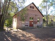
Weir Village Rd Mundaring Weir
to be included in P8538 Mundaring Weir Precinct assessment
Mechanics' Institute
Mundaring
Metropolitan
Constructed from 1908
| Type | Status | Date | Documents |
|---|---|---|---|
| Heritage List | YES | 08 Mar 2016 | |
| State Register | Registered | 22 Jan 2002 | HCWebsite.Listing+ListingDocument, HCWebsite.Listing+ListingDocument |
| Type | Status | Date | Documents |
|---|---|---|---|
| (no listings) |
| Type | Status | Date | Grading/Management | |
|---|---|---|---|---|
| Category | ||||
| Municipal Inventory | Adopted | 22 Apr 1997 | 2 -Considerable significance | |
| Classified by the National Trust | Classified | 09 Jul 2001 | ||
| Register of the National Estate | Indicative Place | |||
08538 Mundaring Weir, Gardens and Village Precinct
Appears sound but has movement in the exterior west wall
| Library Id | Title | Medium | Year Of Publication |
|---|---|---|---|
| 6452 | Mundaring Weir Precinct masterplan : final master plan report. | Heritage Study {Other} | 2002 |
Individual Building or Group
| Epoch | General | Specific |
|---|---|---|
| Original Use | SOCIAL\RECREATIONAL | Other Community Hall\Centre |
| Present Use | SOCIAL\RECREATIONAL | Other Community Hall\Centre |
| Other Use | SOCIAL\RECREATIONAL | Mechanics Institute |
| Style |
|---|
| Federation Arts and Crafts |
| Type | General | Specific |
|---|---|---|
| Wall | BRICK | Common Brick |
| Roof | METAL | Corrugated Iron |
| General | Specific |
|---|---|
| SOCIAL & CIVIC ACTIVITIES | Institutions |
| SOCIAL & CIVIC ACTIVITIES | Cultural activities |
| OCCUPATIONS | Technology & technological change |
This information is provided voluntarily as a public service. The information provided is made available in good faith and is derived from sources believed to be reliable and accurate. However, the information is provided solely on the basis that readers will be responsible for making their own assessment of the matters discussed herein and are advised to verify all relevant representations, statements and information.
Mundaring Weir Gallery, has cultural heritage significance for the following reasons: the place is a reminder of the once thriving community that formerly existed at Mundaring Weir; the place has historical associations with the Goldfields pipeline and Fred Jacoby; the place is historically associated with the Mechanics' Institute movement; the place is held in high esteem by the people of Mundaring and Mundaring Weir; and, the place is representative of the type of building constructed by local community groups to service as their Institute Hall.
Mundaring Weir Gallery is a single storey brick and iron building completed in 1908 as a Mechanics Institute for the community of Mundaring Weir. The building sits on-a sloping site which has been terraced at the front to provide parking. Two terraces are also-located on the north eastern side of the building and were formerly the location of two tennis courts. The building has a simple rectangular form and stylistically could be termed as a fairly plain version of Federation Arts and Crafts. The brick walls, laid in English bond, sit on an undressed stone foundation which is approximately 30cm above ground at the front, gradually increasing in height towards the rear of the building. The stone used is local granite. Above the stone foundation are three courses of brickwork which form a plinth for the brick walls which rise above. The gable roof is clad with Zincalume and there are no gutters. Stylistically, the Arts and Crafts elements are to be found on the front wall. The apex of this wall is decorated with pebble dash into which has been set three narrow, rectangular ventilation louvres. The front facade has a centrally located entrance with a fanlight above a pair of sheeted, ledged and braced double doors. A new yale lock has been fitted to one door. The original, metal door knob has been retained. On either side of the door are fixed, timber framed windows with three panes and fanlights. The door and window openings feature brick arches with a metal arch band. A marble foundation stone is fixed just below the window on the western side of the front facade. The stone records the following details: This stone was laid _by the Hon. James Price MLA Minister for Works 9th May 1908. Committee: H. Ball, Chairman, A.G. Eggleton, Fred W. Jacoby, E.S.A. Willis Hon. Sec. The rear wall is timber framed and clad with painted, sheets of corrugated galvanised iron. These sheets were probably placed here sometime after 1965 when the rear toilet section was demolished. The exact date of this demolition is not known. As this side is half a storey higher than the front, a storage area has been created beneath the floor area. The iron cladding covers this wall to floor height. Below this cladding the wall is undressed stone. A pair of ledged and sheeted doors are located at the western end of this wall, at floor height and a staircase" leads down to ground level. These stairs have a pipe balustrade and timber treads. _A pair of double doors is centrally located in the stone section of the wall providing access to an under floor storage area. The opening is faced with brickwork. The two side walls are identical. Three windows are evenly spaced along the walls. The windows are the same style as those found in the front elevation. Wall vents have been placed between the windows and under floor ventilators are located at intervals, down both sides of the brickwork, above the stone foundation. The south west wall has several long cracks which run down the wall from the centre of the southern and central windows. The brick arches above both these windows also show evidence of past movement. Without the benefit of monitoring it is not possible to determine if movement is still occurring in this wall. The north easier wall shows no evidence of movement. The interior of the hall is basically a rectangular open space. The timber floor is covered with carpet. The ceiling is plasterboard with the gaps between the sheets covered with plastic cover strips. The rear wall is clad with painted,tongued and grooved boards (laid underside up). Timber picture rails have been fitted around the walls however, these are not original. The current fittings are all modern and the shelving which is used to display craft items are free-standing and could be easily removed.
Assessment 2001 Construction 1908 Builder: Mr Jordan The locality around present day Mundaring Weir was first settled in 1882 by Walter Jecks who owned the Rose and Crown in Guildford. Jecks established a vineyard and orchard on his land which lay to the north east of the dam site in an area known toady as Jacoby Park. Jecks was soon joined by both his brothers Thomas and John Allpike who managed Padbury’s Guildford stores. In 1883 F.W. Byfield occupies occupied Swan Loc. 1324 slightly to the east of the dam site. The discovery of gold around Coolgardie and Kalgoorlie in the 1890s, led to a large influx of people into what was a comparatively arid area. An additional factor to this equation was the development of the Eastern Railway which while providing access to the goldfields, also required large quantities of water to run the steam locomotives. A solution to the problem of a lack of water to this area was provided by C.Y O'Connor (Chief Engineer in the Department of Public Works) in 1895. O'Connor proposed constructing a pipeline from the Perth area out to the eastern goldfields. The Coolgardie Goldfields Water Supply Scheme came into being in 1896 and a location on the Helena River was chosen as a dam site. A spur line from the Eastern Railway line to the reservoir site was the first requirement and this was completed in June 1898.6 The pipeline was officially opened on 22 January 1903 by Lady Forrest. Housing was provided for the employees who operated the No. 1 Pumping Station and the nearby No. 2 Pumping Station (O'Connor) and a small community sprang up around the Mundaring Weir Hotel which had been established by the Jacoby brothers (Mathieson and Frederick), in 1898. In 1906, members of this community fanned a committee to raise funds for the construction of a Mechanics' Institute building. The members of the committee included Harry Ball, A. Eggleston, (engineer in charge of the No 1 Pumping Station), Fred Jacoby (the hotel owner) and Eli Will is (the local school master). Over a period of two years the committee raised the sum of £70 and were successful m receiving a subsidy of £203 from the government. The hall was constructed by Mr Jordan of Parkerville. The final cost of the building was £308. The Weir Gallery was officially opened on the 9 May 1908 by Mr Price, Minister for Works. The building proved to be a popular venue with the local community and at some stage (possibly the 1920s), two tennis courts were constructed on the north east side of the building. During the 1920s and 1930s, large numbers of tourists flocked to the Weir to enjoy the picnic grounds. The popularity of the Weir as a tourist destination declined during the Depression years13 and in 1936, the Secretary of the Mechanics' Institute wrote to the Mundaring Road Board requesting assistance in making repairs to the hall.14 It is not known if this was forthcoming. During the 1950s; the population at Mundaring Weir declined when the steam engines at the No. 1 pumping station were replaced with electric engines and No. 2 pumping station was decommissioned. By the 1960s, Mundaring Weir Gallery had fallen into disrepair and in March 1965 a Health Inspector sent a letter to the Shire o fMundaring noting that the rear portion of the hall, which housed the toilets, was riddled with termites and was in danger of collapse. At this stage the Shire of Mundaring was not willing to take on the up-keep of the hall. It is not known if the tennis courts were still in use at this time. The building ceased to be used by the Mechanics' Institute in November 1968. In 1971, Mundaring Weir Gallery was vested with the Shire of Mundarmg.During the 1970s the building was used as a local art gallery. In January 1973, the Art Co-Op Group arranged to lease the building from the Shire. Mundaring Weir Gallery was placed on the National Trust of Australia's (WA) Recorded list in August 1978. The photograph taken at the time of the assessment shows the building much as it appears today with the exception that the original corrugated galvanised roof was still in place.21 It is not known when the roof was re-clad with Zincalume sheeting. Today the hall is leased from the Shire of Mundaring by the Eastern Hills Arts and Crafts Inc.22 This is the same group as the Art Co-op. The craft group display and sell local arts and crafts to tourists and maintain the building.
This information is provided voluntarily as a public service. The information provided is made available in good faith and is derived from sources believed to be reliable and accurate. However, the information is provided solely on the basis that readers will be responsible for making their own assessment of the matters discussed herein and are advised to verify all relevant representations, statements and information.
Constructed from 1908
16610 Goldfields Water Supply Scheme
The Mundaring Weir Hall (Mechanic Institute) has very high social and historical significance for Mundaring, for it's associations with the early community supporting the Weir, pumping stations, forestry and agricultural industry of the area.
The Mundaring Weir Hall is opposite the Mundaring Weir Hotel on the corner of Weir Village Road (formerly Mundaring Weir Road) and Hall Road. The brick building is a simple rectangular form with corrugated iron roof and gable walls at each end. The brick walls, sitting on granite footings, are of "English" bond, although the rear wall has been built of framed construction clad with corrugated iron awaiting future extensions which have not occurred. The long brick side walls have three evenly spaced windows with highlights and arched brick lintels. The front brick gable end wall is tall and imposing, incorporating a central ledged and braced double entry door with highlight over and arched brick lintel. Either side of the door a pair of windows with arched brick lintels balances the symmetry. The triangular peak of the gable entry wall is finished with a roughcast stucco rendered panel inset with three narrow, vertical ventilation louvres separated by brick piers. The overall effect is one of Federation Free Style / Arts and Crafts styling. The front wall contains an engraved marble foundation stone which has to compete for attention with unsympathetic signage (including the "Gallery" sign) on the wall which, together with an intrusive meter box and power connection, detract from the frontage.
As local community and education centres, halls and Mechanics Institutes were an important part of early social and cultural history. Western Australia's first Mechanics Institute was established in Perth in January 1851. The closest one for hills residents was at Guildford, built in 1865. In 1906, the same year Midland Junction opened their Mechanics Institute, Mundaring Weir citizens, Harry Ball, Eli Willis, Fred Jacoby and Engineer-in-Charge of the No. 1 Pumping Station, Mr. A Eggleton, began to raise funds for the Mundaring Weir Hall and Mechanics Institute. Delays in construction caused by storm damage meant the building was not ready for official opening until April 1908. A crowd of 200 people attended the opening by M.L.A. Mr A.C. Gull. The foundation stone shows the name of James Price, Minister for Works and Mr Jordan as the Builder. An indication that the community was expected to grow can be seen in the temporary nature of the corrugated iron rear of the Hall. In the 1920s and 30s, after the forestry headquarters were established at nearby 'Portagabra' (Site 60), the hall and nearby tennis courts were used for dances and tennis. Between c 1947 and 1951, when the wall of the Mundaring Weir (Site 55), was being raised, children of the construction workforce were taught here as an overflow class from the Mundaring Weir school (Site 58). The building was well used by local people until, with declining population levels, it fell into disrepair. In the early 1980's, the Shire of Mundaring rehabilitated the building for use by community groups.
Integrity: High - although the Hall is now used as a Gallery
Good
| Ref ID No | Ref Name | Ref Source | Ref Date |
|---|---|---|---|
| FK Crowley; ibid pp. 51, 55, 80 | |||
| I Elliot; ibid p. 142 | |||
| MHHS interview; "mrs H Hunt" | 25/9/1995 | ||
| MHHS File; "Mundaring Weir". | |||
| CT Stannage; "A new history of Western Australia". pp. 606-607 | UWA Press | 1981 | |
| MJ Bourke; "On the Swan". pp. 216, 269 |
This information is provided voluntarily as a public service. The information provided is made available in good faith and is derived from sources believed to be reliable and accurate. However, the information is provided solely on the basis that readers will be responsible for making their own assessment of the matters discussed herein and are advised to verify all relevant representations, statements and information.
Cnr Roland & Beacon Rds, nr Cnr Wilson Rd Parkerville
Inc: Padbury Centre; Workshop; Trade Workshop; St Gabriels Cottage; Chapel of St Michael & All Angels; Wearne Centre; Rosemary Cottage; Blue Cottage; George Turner Cottage; Wattle Cottage; Kindergarten; Workington Hall & Director's residence. NOT INCLUDED: Narbethong, Uralla, Waminda & Baroonga
Babies / The Waifs Home
League of Charity Home for Waifs & Stray
Mundaring
Metropolitan
Constructed from 1903, Constructed from 1906
| Type | Status | Date | Documents |
|---|---|---|---|
| Heritage List | YES | 08 Mar 2016 | |
| State Register | Registered | 24 Nov 2000 | HCWebsite.Listing+ListingDocument, HCWebsite.Listing+ListingDocument |
| Type | Status | Date | Documents |
|---|---|---|---|
| (no listings) |
| Type | Status | Date | Grading/Management | |
|---|---|---|---|---|
| Category | ||||
| Municipal Inventory | Adopted | 22 Apr 1997 | 1 - Exceptional significance | |
| Name | Type | Year From | Year To |
|---|---|---|---|
| Ednie-Brown | Architect | - | - |
| F.G.B. Hawkins | Architect | - | - |
| Library Id | Title | Medium | Year Of Publication |
|---|---|---|---|
| 7202 | Echoes of the past : Sister Kate's Home revisited. | Book | 2002 |
| 9466 | Signposts: a guide for children and young people in care in WA from 1920. | Electronic | 2010 |
| 4045 | Parkerville Children's Home : conservation plan. | Heritage Study {Cons'n Plan} | 1999 |
| 8802 | Sister Kate : a life dedicated to children in need of care. | Book | 1999 |
Individual Building or Group
| Epoch | General | Specific |
|---|---|---|
| Present Use | RESIDENTIAL | Institutional Housing |
| Original Use | RESIDENTIAL | Institutional Housing |
| Type | General | Specific |
|---|---|---|
| Wall | BRICK | Common Brick |
| Roof | METAL | Corrugated Iron |
| General | Specific |
|---|---|
| SOCIAL & CIVIC ACTIVITIES | Institutions |
This information is provided voluntarily as a public service. The information provided is made available in good faith and is derived from sources believed to be reliable and accurate. However, the information is provided solely on the basis that readers will be responsible for making their own assessment of the matters discussed herein and are advised to verify all relevant representations, statements and information.
Constructed from 1903, Constructed from 1959
The Parkerville Children's Home has very high social and historic significance for ht epeople of the Mundaring community, former residents and the State generally for it's role it has played in the care of children. The place is significant historically and socially for it;s approach to 'cottage care' for children long before it was appreciated as a better alternative than 'institutionalised' care. It also has important historic significance for it's associations with public figures of the day such as Walter Padbury, Charles Harper, JH Worthington and Sister Kate Clutterbuck.many of the buildings have high aesthetic significance which are further complimented by their setting.
Parkerville Children's Home is set on an undulating rural bush site with a large collection of buildings distributed around the property. These range from cottages, old school and chapel, all associated with children's the welfare, through the day to day necessities of operating the place such as the dining room, laundry, staff and management facilities. The buildings are many and varied having been built from as early as 1906, and through to the late 1970's. The old school is now used as an administration centre, is one of the most significant buildings in the site. It is a brick building with a "U" shaped plan formed by two former classrooms at either end of a large hall or assembly space which features a large, segmented arched window. The hall is now partitioned to form several smaller office and meeting spaces; however, the partitions have been sensitively integrated with the high ceilings in a manner that would be reversible and does not interfere with the original fabric. Several of the accommodation cottages have had or are in the process of some conservation and restoration. The weatherboard George Turner cottage, 1929, is now an education centre, and St Gabriels, 1910, is being taken back closer to it's original form with many accretions and verandah enclosures being removed to reveal the original form of the place. The cottage has a large central space with mini corrugated iron ceiling linings, boarded dados around the walls and tall double hung windows including a step through window going right to the floor. Padbury Cottage built in 1906 is the oldest and most significant of the cottages. It has recently been carefully restored closely to what would have been it's original character. Generally the work has been carried out sensitively although the choice of some materials could be questioned and there maybe some concern about possible damp problems in the front walls becoming a problem where brick paving has been replaced the timber boarded verandah. Overall Padbury Cottage sets an example for other buildings on the site which needs a conservation plan to guide future reimbursement work and adaption of the buildings. The red brick dining hall, first built in 1936, and altered in 1967, is in urgent need of repairs. It's art deco style contrasts with the older buildings on the site.
In the winter of 1903, the Parkerville Children's Home, originally known as the "Emily Ayckbowm Home for Waifs & Stray Babies", or "Waifs Home", was established on part of the present site, by the Anglican Order of the Sisters of the Church. One of the original Sisters, Sister Kate (Katharine Mary Clutterbuck), was in charge of the Home from its inception until her "retirement" in 1933, when she founded Sister Kate's Children's Home in Queens Park. The site of the Parkerville Children's Home had previously been the location of a sawmill belonging to the Sexton brothers (Site 153). The Sister's first accommodation, an old slab-sided barn, no longer exists. By early 1906, a brick cottage, financed by Guildford resident, Walter Padbury, and said to be one of the first brick buildings in the Parkerville area, was officially opened. The timber cottage "St. Nicholas", donated by Sister Kate's father, was opened on the same day. Other timber cottages at the time were "The Lodge" ( the first nursery built in 1903), "Noah's Ark" (1904), "Guildford" (1905) and "Beaconsfield". A brick school house, and dining room and kitchen were erected and a steam engine was put in to supply the Home with water. In September 1909, the original timber chapel of St Michael and All Angels was consecrated and the Home was added to the list of State orphanages. Initially, the home survived primarily on philanthropic donations, and voluntary efforts from people such as Walter Padbury, Charles Harper, Sister Kate's father, the Guildford Anglican Minister's wife Mrs. W. Everingham, and funds from the Sisters' Anglican High School, now Perth College. Later, the efforts of J.H. Worthington, Company Secretary of Wesfarmers, were recognised when the dining hall, originally built in 1936, was refurbished in 1967 and renamed in his honour. Although modified in later years, the cottage care system instituted by the Sisters was in marked contrast to the large two storey buildings operating for the care of children elsewhere. This deliberate decision by the Sisters to raise the children in as homelike an atmosphere as possible, surrounded by an attractive, natural environment, was unusual for the time and is similar to current childcare philosophy. The numbers of children at Parkerville Children's Home increased from 22 in 1903, to approximately 109 in 1914. A kindergarten commenced in the Easter term of 1912, in a room in "St Gabriel's " cottage. This was the same year as the first kindergarten in WA, and was claimed to be the first kindergarten in an institution in Australia. In 1913, a large room was added to "The Lodge", to make a new school with two classrooms. This school, with further additions, operated until 1949, when the children attended the separate Parkerville Village School (Site 72). When Sister Kate left Parkerville in 1933, she was replaced by two Sisters from the Anglican Community of the Sacred Advent in Brisbane. The laundry, dining hall and kitchen, were built in 1936. In 1940, control returned to the Sisters of the Church. Their residence was built in 1941. After the Second World War, the Home operated with a Board, and a series of managers including Major Owens, Jack Wales, Bill Couche, Jim Semple and in 1978, the present Director, David Roberts. In the early 1970s, the re-introduction of the Sister's philosophies and objectives reduced the number of children in each cottage and saw the introduction of the first qualified social worker and education officer. In 1976, four brick cottages (Narbethong, Ural la, Waminda and Barooga) were built. In 1979 and 1981, two associated cottages were built in Belmont and Fremantle. At the present, the site's most significant remaining buildings include; Padbury House (1906), St. Gabriels (c. 1910), timber cottages from the 1920's and 30's, George Turner Cottage (1929) which was donated by the Theatrical Employees Association and designed by architect Ednie-Brown, the school buildings (c. 1914), the Chapel (1909, 1922 and 1959), the dining room (1936 & 1967), Sisters Residence (1941), and trees such as large pines, marri and jarrah. Parkerville Children's Home (Inc) operates under the auspices of the Anglican Church. It is a residential child care facility using the cottage system with appropriate social work and education support services, thereby maintaining the ideals of the founding Sisters.
Integrity: Very High, with most buildings still serving their original uses. Modifications: Various alterations, additions and adaptions to different buildings.
very good- well maintained, some conservation work and reimbursement carried out.
| Name | Type | Year From | Year To |
|---|---|---|---|
| Ednie-Brown Turner Cottage; | Architect | 1929 | - |
| Ref ID No | Ref Name | Ref Source | Ref Date |
|---|---|---|---|
| MHHS File; "Parkerville". | |||
| D Lapham; "Parkerville Cjildren's Home: Historical Timeline". | 1995 | ||
| I Elliot; ibid. pp. 252, 254 |
| Owner | Category |
|---|---|
| Parkerville Children's Home Incorporated | Inc. Non-profit body |
This information is provided voluntarily as a public service. The information provided is made available in good faith and is derived from sources believed to be reliable and accurate. However, the information is provided solely on the basis that readers will be responsible for making their own assessment of the matters discussed herein and are advised to verify all relevant representations, statements and information.
900 Woodlands Rd Stoneville
Padbury Boys' Farm
Mundaring
Metropolitan
Constructed from 1955, Constructed from 1970
| Type | Status | Date | Documents |
|---|---|---|---|
| State Register | Registered | 01 Oct 1999 | HCWebsite.Listing+ListingDocument, HCWebsite.Listing+ListingDocument |
| Type | Status | Date | Documents |
|---|---|---|---|
| (no listings) |
| Type | Status | Date | Grading/Management | |
|---|---|---|---|---|
| Category | ||||
| (no listings) | ||||
The only buildings that now remain on this site are the Church (Chapel), Gymnasium and Hall and the Science Building. All other buildings and surrounding infrastructure were demolished during construction of the Kath French Centre in 1999. See P file for list of demolished buildings.
| Name | Type | Year From | Year To |
|---|---|---|---|
| Rev W Churchill - chapel | Architect | - | - |
| Public Works Dept | Architect | - | - |
| Library Id | Title | Medium | Year Of Publication |
|---|---|---|---|
| 9601 | Hillston boys' farm (fmr): assessment of significance. | Heritage Study {Other} | 1998 |
| 4077 | Hillston Boys' Farm (fmr) Archival Record | Heritage Study {Other} | 1999 |
Individual Building or Group
| Epoch | General | Specific |
|---|---|---|
| Original Use | GOVERNMENTAL | Other |
| Original Use | RELIGIOUS | Other |
| Present Use | GOVERNMENTAL | Town, Shire or District Hall |
| Original Use | EDUCATIONAL | Special School |
| Original Use | RESIDENTIAL | Other |
| General | Specific |
|---|---|
| SOCIAL & CIVIC ACTIVITIES | Institutions |
| SOCIAL & CIVIC ACTIVITIES | Religion |
This information is provided voluntarily as a public service. The information provided is made available in good faith and is derived from sources believed to be reliable and accurate. However, the information is provided solely on the basis that readers will be responsible for making their own assessment of the matters discussed herein and are advised to verify all relevant representations, statements and information.
Linley Valley Rd Wooroloo
Wooroloo Hospital, Wooroloo Training Centre
Wooroloo Prison Farm
Mundaring
Metropolitan
Constructed from 1915
| Type | Status | Date | Documents |
|---|---|---|---|
| Heritage List | YES | 08 Mar 2016 | |
| State Register | Registered | 30 Aug 2002 | HCWebsite.Listing+ListingDocument, HCWebsite.Listing+ListingDocument |
| Type | Status | Date | Documents |
|---|---|---|---|
| (no listings) |
| Type | Status | Date | Grading/Management | |
|---|---|---|---|---|
| Category | ||||
| Municipal Inventory | Adopted | 22 Apr 1997 | 1 - Exceptional significance | |
| Name | Type | Year From | Year To |
|---|---|---|---|
| WB Hardwick | Architect | - | 2002 |
| Hillson Beasley | Architect | - | - |
| Library Id | Title | Medium | Year Of Publication |
|---|---|---|---|
| 5726 | Wooroloo Sanatorium (fmr) (Wooroloo Prison) : conservation plan. | Heritage Study {Cons'n Plan} | 2002 |
| 6062 | Shedule of conservation works for the former Secretary and Dispenser's Quarters (Brambley Hedge), 29 Swimming Pool Road, Wooroloo Sanatorium (fmr) (Wooroloo Prison). | Conservation works report | 2002 |
| 5368 | Wooroloo Sanatorium (fmr) : heritage assessment. | Heritage Study {Other} | 2001 |
| 6405 | Archival record for 14 staff cottages : Wooroloo Sanatorium (fmr) (Wooroloo prison). | Archival Record | 2002 |
Individual Building or Group
| Epoch | General | Specific |
|---|---|---|
| Present Use | HEALTH | Housing or Quarters |
| Present Use | GOVERNMENTAL | Gaol |
| Original Use | HEALTH | Housing or Quarters |
| Original Use | HEALTH | Hospital |
| Style |
|---|
| Federation Queen Anne |
| Federation Arts and Crafts |
| Type | General | Specific |
|---|---|---|
| Other | TIMBER | Other Timber |
| Roof | METAL | Corrugated Iron |
| Wall | BRICK | Rendered Brick |
| Wall | RENDER | Smooth |
| Wall | ASBESTOS | Fibrous Cement, flat |
| Wall | RENDER | Roughcast |
| Other | CONCRETE | Other Concrete |
| General | Specific |
|---|---|
| SOCIAL & CIVIC ACTIVITIES | Law & order |
| SOCIAL & CIVIC ACTIVITIES | Community services & utilities |
| SOCIAL & CIVIC ACTIVITIES | Institutions |
This information is provided voluntarily as a public service. The information provided is made available in good faith and is derived from sources believed to be reliable and accurate. However, the information is provided solely on the basis that readers will be responsible for making their own assessment of the matters discussed herein and are advised to verify all relevant representations, statements and information.
Constructed from 1915
The Wooroloo Prison/Sanatorium has very high aesthetic, social, historic and scientific cultural significance for the Shire of Mundaring and the State of Western Australia. It's setting, layout and design together with it's very good condition and authenticity give it very high aesthetic significance. The sanatorium's role in the treatment of tuberculosis, and later it's use as a prison all contribute to it's very high social, histoic and scientific significance. in addition, the extent and integrity of th site contributes to it's rarity and representatives as an example of sanatorium/hospital and an illustration of the tuberculosis health care philosphy from the earlier part of the 20th century.
The buildings of the Wooroloo Prison/Sanatorium are set out along curved tiers on the contours of the site sloping down to the oval and the valley to the east. The extent and integrity of the site is impressive as the dormitories radiate either side from the central core of buildings in the complex which form a backbone to the planning of the place. As the core buildings step down the hill they provide dining rooms, stores (former power-house ?), laundry, boiler-house, administration and recreation facilities. The hospital extends as a wing to the north and, separated at the ends of various wings, there are other individual buildings for such necessities as staff accommodation and, in an isolated location to the north, a mortuary. Further east down the valley, and some 500 metres or more away, are several concrete floor slabs and trees which are all that remains to mark the site of the former leprosarium. The light coloured walls and green painted corrugated iron roofs provide a unity that compliments the setting and form of the site. Generally the walls of the buildings are reinforced concrete with an external exposed laterite aggregate, giving a stucco like appearance, whilst internally the walls are rendered smooth for health reasons. It appears only the Matron's House, north of the hospital, has retained its original 'off-form' natural colour where most other buildings have been painted externally in various pastel shades or white. Whilst the architectural style is simple, especially for the turn of the century 'Federation' period, the design is interesting for construction detailing which focuses on capturing breezes and keeping the buildings airy and cool. Verandas and large overhangs, supported on 'gallows' brackets, protect walls from the sun and arched openings at ground level around the perimeter of the buildings and verandas allow breezes to circulate under the buildings and cool them. The long runs of dormitories, housing up to 300 beds overall, follow a linear plan form, one room wide and strung out along access verandas. Originally the rooms had sections of openable timber framed walls to allow the full extent of the cooling and health giving breezes to pass through and give plenty of invigorating fresh air to patients. These walls have now been built in with windows and timber framing, clad with vertical T&G boarding and asbestos sheeting. Several dormitory wings have been modified in pragmatic ways over the years such as the replacement of timber windows with aluminium. Several free standing red brick, flat roofed toilet blocks have also been constructed just off the verandas and these could have been better integrated with rendering and pitched roofs. The centre of each dormitory wing is punctuated by a projecting half octagon room that were nursing station to service that wing of the sanatorium. The hospital is located in a central wing running to the north beyond which are the separate Superintendent's and Matron's houses, and further on, the old mortuary. Also to the north, and higher up the hill, is a derelict timber framed, weatherboard and asbestos building, built c 1950's and probably providing nurses quarters or the like. The eight bed hospital still provides services to the surrounding district as well as the prison and is administered by the Board of the Swan Districts Hospital. The building housing the hospital was built later (late 1930's?) than the rest of the complex and may have replaced an earlier building or took over from a smaller building in the central core. Its external brick appearance and weatherboard/asbestos veranda enclosures contrast with the concrete material of the original complex. Internally it is very plain and austere, probably having been 'updated' over the years. The nearby 'Matron's House' is a large 'L' shaped residence with a front veranda terminating against a projecting room. The external appearance of the house retains the original earthy tones of the unpainted laterite aggregate concrete walls. Elsewhere, walls have generally been painted and the original colourings have been lost. It is important that the walls of the 'Matron's House' remain unpainted to illustrate the original materials and colouring of the complex. The house also demonstrates the arched ventilation openings at the base of the walls around the perimeter of the house to cool the underfloor of the building. Internally the front rooms of the house are relatively decorative with high ceilings featuring timber fireplace surrounds, picture rails, deep cornices and ceiling roses. The nearby Superintendant's house, with painted pastel yellow walls, was not inspected but appears to be in similar style but somewhat larger. Further tot he north the mortuary is located on a site isolated from the rest of the complex. It is a small two roomed building with very tall walls and highlights windows (originally glazed with obscure glass of which only the fragments remain). The upper tier of core buildings, forming the backbone to the layout, have several large, tall structures, (not inspected internally). One is now used as a staff "club" from which recreation, dining and localised administration may have previously functioned. The middle tier is dominated by the laundry, boiler house and maintenance buildings which are tall, open, utilatarian buildings with exposed roof trusses and skylights. Behind the laundry is the "Stores" building set into the side of the hill and backed with laterite retaining wall at the rear and weatherboard infill at the front. Several pairs of large scale double access doors have also been infilled and internally there is a relatively close grid of timber columns supporting the roof. There are machinery service pits in the floor, and it is thought that the building was previously a garage. The age of the complex would suggest they could have been stables originally. Alternatively, as electrical transformers are today located behind (and above) the retaining wall of the 'Store', the building may have been the former power house. It is in a central location which is ideal for the distribution of power. The administration building is on the second lowest tier and has a formal entry from the lower east side with a flight of steps sweeping up to an entry portico. A decorative pediment is supported each side of the entry by four timber posts with simple brackets and detailing. The entry portico leads to a half octagonal reception are projecting from the centre of the administration wing much like the form of the dormitory wings but on a larger scale. Externally the entry provides one of the few elements on the site that outwardly establishes the 'Federation Free Style' character of the period in which the complex was built. Below the Administration building on the lowest tier and overlooking the oval is the Recreation Hall. According to the foundation stone, it was built in 1922, by a benevolent society of the day "The Ugly Men's Voluntary Workers Association of WAS Inc.". The Hall varies from other buildings in having been constructed later and appearing to have been designed independently. It is of brick construction with panels of stucco rendered walls at each end anmd with continuous double hung, six paned windows between roof support columns down each side. The entry and small projection room form an attachment on the west end. The internal space of the hall has an unusual form created by a ceiling vault following a curved line on the underside of the timber trusses. The ceiling material is a painted flat sheet material, possibly not original, and the curved form is carried through to the arched proscenium over the raised stage at the east end of the hall. The only other significant building on the site is what is now the Education Centre of Mitchell House, named after the first Chief Residential Medical Officer. It is separated from the rest of the buildings and is located off the end of the south-west wing. The spacious house rises above the ground level at the front and has a sweeping set of steps leading to the entry on the verandah. It has verandahs n the east and north under a large corrugated iron, hipped roof with a series of gambrel ends. The front of the roof is dominated by a projecting, semi-enclosed attic type sun room or look-out with timber posts and shutters. Access is gained from the entry hall via a large jarrah staircase of a scale indicating that it provides access to more significant first floor accommodation than just a look-out. The detailing of the stair balusters incorporates an unusual motive possibly art-nouveau origins. The walls if the house are painted reinforced concrete textures aggregate and the window openings have a decorative rendered surround. Internally the front rooms are very large with provisions to open up two of the rooms through folding timber doors. The front rooms have picture rails, high ceilings and decorative cornices and ceiling roses. large fireplaces with detailed timber surrounds dominate the formal rooms. The less formal rooms are to the rear and, whilst still comparatively large, are more simply finished and detailed. The back of the house is virtually at ground level giving direct access to what originally would have been a separate external kitchen pavilion. A bushfire in January 1997, burnt out various buildings but there has been no further assessment by the consultants.
A sanatorium for the treatment of tuberculosis ("T.B."), or consumption as it was also known, was built in the relative isolation of Wooroloo and, officially opened on 1st May 1915. The place was also referred to as the Wooroloo Lazaret. Prior to the sanatorium's completion at Wooroloo, a site had been temporarily reserved in c. 1904, at Mahogany Creek. In 1910, an attempt was made to set aside land for a sanatorium at Chidlow's Wells, on part of the Government Railway's water supply reserve, part of which was later Lake Leschenaultia (Site 200). The negative response that; "it may be the means of spreading disease to the public through the water supply", reflected general disquiet about the disease and probably accounts for why, along with the perceived restorative qualities of the hills air, it was finally located in Wooroloo. The presence of a small number of leprosy patients (some 6 in 1936), isolated from each other and the "T.B." patients, was possibly a source of concern to the local population. Objections to the presence of lepers in the sanatorium is evidenced in letters to the 'West Australian' in September and October 1936, claiming it was ruining the district, and reducing property values. The local Undertaker, Mr. Bullen, was said to consider burying the dead patients a health hazard, warranting extra payment. In c. 1912, the sanatorium buildings were designed under the auspices of the Public Works Department Chief Architect Hillson Beasley. He worked in conjunction with various District Medical Officers, including Wooroloo's first Chief Residential Medical Officer, Dr. R.M. Mitchell, formerly of the Coolgardie Sanatorium. Work began in mid 1913. Locally quarried and crushed stone was used to make the reinforced concrete buildings, whose smooth finished interior walls and floors allowed effective disinfection procedures. Patients were segregated according to gender, and the severity of their case. The open fronted 10 bed wards, orientated north and east, were designed to maximize patient fresh air and sunlight. As well as providing for male and female staff, there were buildings to house administration, a laboratory, operating room, kitchen, dining room, billiard room, and a school for younger patients. In addition, the sanatorium had its own laundry, bakery, and power-house, making it a relatively self-contained operation. Building materials not produced on site arrived from the Wooroloo siding, via a temporary tramway. Built to house 300 patients (200 male and 100 female), there were initially only 80 patients, many of them ex-miners from the Eastern Goldfields. From the late 1930's, Wooroloo was used as a preliminary 6-8 week training school for both male and female trainee nurses. Until the 1944 discovery of Streptomycin, rest, fresh air and good food were the only hope for T.B. patients. Many of them ended up in the nearby Wooroloo Cemetery (Site 210). With improved treatment, compulsory diagnostic chest x-rays and development in the late 1950's, of the Perth Chest Hospital, Wooroloo became a District Hospital, with a maternity section from 1962. Patients with multiple sclerosis, stroke and paraplegic victims and alcoholics were also referred there until its controversial closure in 1970. From then until the present day, the buildings house minimum security prisoners. Newspaper reports, following bushfires in January 1997, recorded that several buildings had been damaged but the extent has not been further investigated by the consultants.
Integrity: Very High- despite adaption from sanatorium to hospital and now prison. Modifications: Various adaptions to suit changing needs of different uses but generally unobtrusive.
| Ref ID No | Ref Name | Ref Source | Ref Date |
|---|---|---|---|
| MHHS File; "Wooroloo". | |||
| v Hobbs; "But Westward Look: Nursing in Western Australia 1829-1979". | UWA Press | 1980 | |
| MHHS File; "Chidlow". | |||
| I Elliot; ibid pp.153-154, 163, 168, 174-175, 198-199, 206-207, 247-249, 254.271-272, ref. p.275 |
| Owner | Category |
|---|---|
| Ministry of Justice | State Gov't |
This information is provided voluntarily as a public service. The information provided is made available in good faith and is derived from sources believed to be reliable and accurate. However, the information is provided solely on the basis that readers will be responsible for making their own assessment of the matters discussed herein and are advised to verify all relevant representations, statements and information.
off Linley Valley Rd Wooroloo
Wooroloo Sanatorium Cemetery
Mundaring
Metropolitan
Constructed from 1906
| Type | Status | Date | Documents |
|---|---|---|---|
| Heritage List | YES | 08 Mar 2016 | |
| State Register | Registered | 30 Aug 2002 | HCWebsite.Listing+ListingDocument, HCWebsite.Listing+ListingDocument |
| Type | Status | Date | Documents |
|---|---|---|---|
| (no listings) |
| Type | Status | Date | Grading/Management | |
|---|---|---|---|---|
| Category | ||||
| Classified by the National Trust | Classified | 12 May 2003 | ||
| Municipal Inventory | Adopted | 22 Apr 1997 | ||
Historic site
| Epoch | General | Specific |
|---|---|---|
| Original Use | MONUMENT\CEMETERY | Cemetery |
| Present Use | MONUMENT\CEMETERY | Cemetery |
| General | Specific |
|---|---|
| OTHER | Other Sub-Theme |
| SOCIAL & CIVIC ACTIVITIES | Community services & utilities |
This information is provided voluntarily as a public service. The information provided is made available in good faith and is derived from sources believed to be reliable and accurate. However, the information is provided solely on the basis that readers will be responsible for making their own assessment of the matters discussed herein and are advised to verify all relevant representations, statements and information.
This information is provided voluntarily as a public service. The information provided is made available in good faith and is derived from sources believed to be reliable and accurate. However, the information is provided solely on the basis that readers will be responsible for making their own assessment of the matters discussed herein and are advised to verify all relevant representations, statements and information.
Constructed from 1902
The Wooroloo Cemetery has high social significance for the Shire, surrounding the district and the State for it's associations as the burial place for early families in the district and the tuberculosis sanatorium in the early half of the 20th century.
The Wooroloo Cemetery is nestled in gently sloping, timbered country east of Wooroloo off Linley Valley Road. It has an attractive white timber entry fence and beyond the entry an old timber gazebo provides shelter for mourners. The centre of the gazebo has an unusual feature, in the form of a small, partitioned, priest's robing room. The gazebo, which is the focus for the main axis road down through the cemetery, has become neglected and in need of restoration or replacement to stave off the ravages of time and termites. The cemetery itself has a slightly neglected feel. Being further from Mundaring and serving a small community, especially now that the tuberculosis sanatorium and hospital have ceased to exist, it suffers from lack of regular use and maintenance. In many respects it is much more attractive than the Mundaring Cemetery and the Shire's efforts to keep it operating are to be commended.
Although the Wooroloo Cemetery was originally surveyed by W.H. Shields on 15th September 1902, it was not gazetted until 13th July 1906. The first Board to control the cemetery appears to have been appointed by the Under Secretary for Lands, Cecil Clifton on 25th June 1916. It consisted of Edward. B. Stephens, William. H.G. Howard, Frank C. Wishart and Ernest Wilson. At least three of the men were prominent in the Wooroloo community. Edward Stephens, a partner with Fred Jones in a grocery and gallon licence at Wooroloo, was also Chairman of the Greenmount Road Board 1909-1913, and a member 1907-13, and 1921-23. It was through his property that a temporary tramway was constructed in 1913 for transporting building materials for the construction of the Wooroloo Sanatorium (Site 194). Frank Wishart had come from Angaston, a fruit growing area in South Australia to Wooroloo in 1898, and was secretary of the Wooroloo Repatriation Sub-Committee. He was a friend and partner of Ernest Wilson, who is best remembered for the 'Buffalo Handle Factory'. This factory which operated until the early 1940s, produced Karri axe and other tool handles for local, interstate and overseas markets. Wilson was also secretary of the Primary Producer's Association, and established the 'Wilson Patent Coolers Company'. On 5th July 1918, following the resignation of the original Board, four new members were appointed to what was described as the 'Wooroloo Sanatorium Cemetery'. The new members included Robert 'Bob' Macfarlane Mitchell, the Chief Residential Medical Officer of the nearby Wooroloo Sanatorium, and its secretary Ernest Chapman Lovely. In the following year, the original four Board members were reappointed as what appears to be additional members, and subsequently the cemetery is only ever referred to as Wooroloo Cemetery. Between 1920 and 1957, resignations and deaths of Board members necessitated appointments on a regular basis. Of the original members, Ernest Wilson was associated with the Board until his death in the early 1940s. Frank Wishart died in 1925, W.H.G. Howard left the district in 1926, and Edward Stephens did likewise in 1934. In March 1945, a critical report from Mr O Bowyer of the Auditor General's office cited problems with the Road Board and the cemetery, including non-payment of undertaker's fees (Including by a company associated with one of the Board members), inadequate record keeping and no Board meeting held since December 1942. The difficulty recruiting and retaining Board members finally came to a head in October 1957, when the then secretary, Wooroloo Postmaster W Thomas resigned, leaving the Board inoperable. On the 29thNovember 1957, the control and management of the Wooroloo Cemetery was vested with the Mundaring Road Board. At present the Shire of Mundaring retains that responsiibilty.
Integrity: High
Fair
| Ref ID No | Ref Name | Ref Source | Ref Date |
|---|---|---|---|
| Government Gazette", p 1160 | |||
| Government Gazette", p 1160 | 23/6/1916 | ||
| "Government Gazette,". p 2143 | 13/4/1906 | ||
| I Elliot; ibid. pp 269, 271, 272, 273 |
| Owner | Category |
|---|---|
| Shire of Mundaring | Local Gov't |
This information is provided voluntarily as a public service. The information provided is made available in good faith and is derived from sources believed to be reliable and accurate. However, the information is provided solely on the basis that readers will be responsible for making their own assessment of the matters discussed herein and are advised to verify all relevant representations, statements and information.