Local Government
Kellerberrin
Region
Wheatbelt
Cnr Goldfields & Mission Rds Kellerberrin
Djuringe Aboriginal Mission and Reserve (fmr)
Old Jiriny Mission;Woolundra Aboriginal Missi
Kellerberrin
Wheatbelt
Constructed from 1934, Constructed from 1966
| Type | Status | Date | Documents |
|---|---|---|---|
| State Register | Registered | 23 Jan 2023 | HCWebsite.Listing+ListingDocument, HCWebsite.Listing+ListingDocument |
| Type | Status | Date | Documents |
|---|---|---|---|
| (no listings) |
| Type | Status | Date | Grading/Management | |
|---|---|---|---|---|
| Category | ||||
| Municipal Inventory | Adopted | 19 May 1998 | Category 5 | |
Ruinous, site only.
Historic Site
| Epoch | General | Specific |
|---|---|---|
| Original Use | RELIGIOUS | Other |
| Present Use | VACANT\UNUSED | Vacant\Unused |
| Original Use | EDUCATIONAL | Other |
| Original Use | PARK\RESERVE | Park\Reserve |
| Type | General | Specific |
|---|---|---|
| Other | BRICK | Common Brick |
| Other | CONCRETE | Concrete Slab |
| General | Specific |
|---|---|
| DEMOGRAPHIC SETTLEMENT & MOBILITY | Settlements |
| SOCIAL & CIVIC ACTIVITIES | Religion |
| SOCIAL & CIVIC ACTIVITIES | Institutions |
This information is provided voluntarily as a public service. The information provided is made available in good faith and is derived from sources believed to be reliable and accurate. However, the information is provided solely on the basis that readers will be responsible for making their own assessment of the matters discussed herein and are advised to verify all relevant representations, statements and information.
Constructed from 1950
The site of the former Woolundra Aboriginal Mission has some local historic and social significance for its association with the local aboriginal people. The site of the Mission is evidence of the role of religious organisations in aboriginal communities.
Situated north east of Kellerber rin on the corner of the Old Goldfields Road and Mission Road, all that remains of the Woolundra Aboriginal Mission are some foundations and tracks.
Operated by the Australian Inland Mission (Methodist Church), the Woolundra Mission included a school and a mission house. The Mission closed in the mid 1960s. [Local Sources]
Site only
This information is provided voluntarily as a public service. The information provided is made available in good faith and is derived from sources believed to be reliable and accurate. However, the information is provided solely on the basis that readers will be responsible for making their own assessment of the matters discussed herein and are advised to verify all relevant representations, statements and information.

17464-17470 Great Eastern Hwy Kellerberrin
Previously referred to as 124 Massingham St, Kellerberrin
Kellerberrin
Wheatbelt
Constructed from 1910
| Type | Status | Date | Documents |
|---|---|---|---|
| State Register | Registered | 14 Jul 2000 | HCWebsite.Listing+ListingDocument, HCWebsite.Listing+ListingDocument |
| Type | Status | Date | Documents |
|---|---|---|---|
| (no listings) |
| Type | Status | Date | Grading/Management | |
|---|---|---|---|---|
| Category | ||||
| (no listings) | ||||
| Library Id | Title | Medium | Year Of Publication |
|---|---|---|---|
| 4246 | Hill View Kellerberrin Conservation Plan | Heritage Study {Cons'n Plan} | 1999 |
| 5017 | Hillview, Kellerberrin: conservation works. Final report. February 2001. | Heritage Study {Other} | 2001 |
| 5515 | Hillview, Kellerberrin : conservation works : cellar (final report). | Conservation works report | 2002 |
Individual Building or Group
| Epoch | General | Specific |
|---|---|---|
| Original Use | FARMING\PASTORAL | Shed or Barn |
| Original Use | RESIDENTIAL | Single storey residence |
| Original Use | FARMING\PASTORAL | Homestead |
| Original Use | FARMING\PASTORAL | Kitchen |
| Present Use | RESIDENTIAL | Single storey residence |
| Style |
|---|
| Federation Bungalow |
| Type | General | Specific |
|---|---|---|
| Wall | TIMBER | Weatherboard |
| Wall | BRICK | Common Brick |
| Roof | METAL | Corrugated Iron |
| General | Specific |
|---|---|
| DEMOGRAPHIC SETTLEMENT & MOBILITY | Settlements |
This information is provided voluntarily as a public service. The information provided is made available in good faith and is derived from sources believed to be reliable and accurate. However, the information is provided solely on the basis that readers will be responsible for making their own assessment of the matters discussed herein and are advised to verify all relevant representations, statements and information.

Cnr Leake & Bedford St s Kellerberrin
District Museum
Kellerberrin Folk Museum
Kellerberrin
Wheatbelt
Constructed from 1898, Constructed from 1937
| Type | Status | Date | Documents |
|---|---|---|---|
| State Register | Registered | 18 Jan 2008 | HCWebsite.Listing+ListingDocument, HCWebsite.Listing+ListingDocument |
| Type | Status | Date | Documents |
|---|---|---|---|
| (no listings) |
| Type | Status | Date | Grading/Management | |
|---|---|---|---|---|
| Category | ||||
| Municipal Inventory | Adopted | 19 May 1998 | category 1 | |
| Register of the National Estate | Nominated | 28 Jul 1983 | ||
| Register of the National Estate | Indicative Place | |||
| Classified by the National Trust | Classified | 08 Mar 1982 | ||
Good
| Name | Type | Year From | Year To |
|---|---|---|---|
| Public Works Department | Architect | - | - |
| Howard Evans | Architect | - | - |
| George Temple Poole | Architect | - | - |
Individual Building or Group
| Epoch | General | Specific |
|---|---|---|
| Original Use | SOCIAL\RECREATIONAL | Agricultural Hall |
| Original Use | EDUCATIONAL | Special School |
| Present Use | EDUCATIONAL | Museum |
| Original Use | EDUCATIONAL | Other |
| Other Use | GOVERNMENTAL | Courthouse |
| Style |
|---|
| Federation Romanesque |
| Type | General | Specific |
|---|---|---|
| Wall | STONE | Local Stone |
| Roof | METAL | Corrugated Iron |
| General | Specific |
|---|---|
| DEMOGRAPHIC SETTLEMENT & MOBILITY | Government policy |
| SOCIAL & CIVIC ACTIVITIES | Sport, recreation & entertainment |
| SOCIAL & CIVIC ACTIVITIES | Law & order |
| SOCIAL & CIVIC ACTIVITIES | Institutions |
| SOCIAL & CIVIC ACTIVITIES | Cultural activities |
| SOCIAL & CIVIC ACTIVITIES | Education & science |
This information is provided voluntarily as a public service. The information provided is made available in good faith and is derived from sources believed to be reliable and accurate. However, the information is provided solely on the basis that readers will be responsible for making their own assessment of the matters discussed herein and are advised to verify all relevant representations, statements and information.
Constructed from 1898
The Former Agricultural Hall has high historic and social significance given that for many years the building was the main social centre of the district. The Hall has been used variously for education local government, law and order as well as recreation and entertainment. The building is a good example of the agricultural halls built with government assistance in many country towns in the 1890s. Further the place is evidence of the use of local materials - stone - which has been used in combination with brick quoining to create an attractive facade. The Hall is held in high esteem locally and now serves as a folk museum where items illustrating the development of the district are displayed.
The former Agricultural Hall is a rectangular shaped building of random stone construction. The stone is locally quarried granite. The place has a steeply pitched corrugated iron gable roof on sawn timber beams with a circular air vent to the gable end and a simple timber finial to the apex. The front facade is limewashed and features a large brick arch and double timber entry doors enhanced by a brick, arch surround. There is brick quoining around the openings and to building corners, providing added strength to the construction. Windows are all timber framed and double hung - there being four to the east elevation along with a double timber door. The building is set on a large block with a variety of farm equipment on display. The block is fenced by a timber and wire mesh fence.
Correspondence between R.B. Leake of the Building Committee for the agricultural hall and the Under Secretary for Public Works indicates that the preferred site for the hall was adjacent to the Post Office: "A reserve of 10 acres is set apart for the post office. If on the eastern side of the post office a block could be granted in this reserve that we suggest would be the most suitable and convenient. It would then be close to the post office to which all frequenting the hall will have business with." [DOLA File - 1 1/6/1898, p9] The correspondence further indicates the proposed use of the hall as a school and therefore the need for an area large enough for a playground. On 7 October, 1898 the south-east corner of Reserve 4461 was set aside as Reserve 5950, Lot 320 as a site for an agricultural hall. [Government Gazette, p2932] A loan of £250 was secured from the government through the Public Works Department to assist in the cost of constructing the hall, which was the first for the district. There was some controversy surrounding the erection of the hall which was during the height of the Gold Rush. The Yilgarn member considered that money could be better spent in his electorate rather than at Kellerberrin where only ":a man and his dog and a dead kangaroo existed." [National Trust file K General, file 1, Appendix B] In 1907 a further £125 was allocated by the government to enlarge the hall. In 1912 there was a move to obtain another site to build a new hall, however, the government would not agree to this proposal given that the loan had not been paid off. The Kellerberrin Road Board took over the building in 1916, and hence inherited the outstanding loan. From 1937 to the 1960s the hall was used as a Courthouse. [Eastern Recorder, 7/2/1957, p6] The Hall was used as a Special School for Handicapped Children until 1972 when a school was built for that purpose. From 1972 the building and grounds were developed as a Folk Museum. [National Trust File] On 27 March, 1975 Reserve 5950 was changed to Reserve 33207 (still Lot 320), it being vested in the Shire of Kellerberrin as a museum site. [Government Gazette, p997] In 1980/81 the Shire Council undertook restoration works which included repairing or replacing and painting all exterior timber work and restoring exterior brickwork and stonework. [HCWA File No. 1369]
Integrity: High Degree
Good
| Name | Type | Year From | Year To |
|---|---|---|---|
| PWD | Architect | 1898 | - |
| Ref ID No | Ref Name | Ref Source | Ref Date |
|---|---|---|---|
| National Trust File - K. | |||
| "Eastern Recorder,". | 7/2/1957. | ||
| BW Leake; "Reminiscences". p 62 | |||
| "Government Gazettes". | |||
| HCWA File No. 1369. | |||
| DOLA File 3005/1898, | State Archives AN 3/3, Acc 541, Item 2005, | 1898 |
| Owner | Category |
|---|---|
| Shire of Kellerberrin | Local Gov't |
This information is provided voluntarily as a public service. The information provided is made available in good faith and is derived from sources believed to be reliable and accurate. However, the information is provided solely on the basis that readers will be responsible for making their own assessment of the matters discussed herein and are advised to verify all relevant representations, statements and information.
This is a good example of the agricultural halls built with government assistance in many country towns in the 1890's and was for many years the main social centre of the district. Local stone has been attractively used on the facade. It is held in esteem locally and now services as a folk museum where items illustrating the development of the district are displayed,
The hall was erected in 1898, the first hall for the district. It is built of local granite with brick quoins, has a corrugated iron roof and wooden floor, originally polished. It served for a period as the district court, until replaced in the 1960's and was then used as a School for Handicapped Children until 1972. In 1975 it was vested in the Shire for a folk museum. The council has restored the exterior brick and stone work and repaired an repainted the exterior timber work, roof and guttering. It stands in a park where native trees and shrubs have been planted and old farmm machinery is displayed
Assessment 1982 Construction late 1890's - 1898 Architect/builder: Public Works Dept
This information is provided voluntarily as a public service. The information provided is made available in good faith and is derived from sources believed to be reliable and accurate. However, the information is provided solely on the basis that readers will be responsible for making their own assessment of the matters discussed herein and are advised to verify all relevant representations, statements and information.

58 Massingham St Kellerberrin
Kellerberrin
Wheatbelt
Constructed from 1912 to 1995
| Type | Status | Date | Documents |
|---|---|---|---|
| State Register | Registered | 11 Aug 1995 | HCWebsite.Listing+ListingDocument, HCWebsite.Listing+ListingDocument |
| Type | Status | Date | Documents |
|---|---|---|---|
| (no listings) |
| Type | Status | Date | Grading/Management | |
|---|---|---|---|---|
| Category | ||||
| Statewide Post Office Survey | Completed | 01 Mar 1992 | ||
| Classified by the National Trust | Classified | 08 Mar 1994 | ||
| Municipal Inventory | Adopted | 19 May 1998 | category 1 | |
17504 Kellerberrin Post Office and Bank of New South Wales (fmr) Group
Good
| Name | Type | Year From | Year To |
|---|---|---|---|
| Hillson Beasley | Architect | - | - |
| Library Id | Title | Medium | Year Of Publication |
|---|---|---|---|
| 6553 | Kellerberrin Post Office : conservation works (final report). | Conservation works report | 2003 |
| 5125 | Conservation plan : Kellerberrin Post Office and Residence / prepared for the owners G. Main & C. Kirby by Laura Gray, Heritage and Conservation Consultant. | Heritage Study {Cons'n Plan} | 2001 |
Individual Building or Group
| Epoch | General | Specific |
|---|---|---|
| Original Use | RESIDENTIAL | Other |
| Original Use | Transport\Communications | Comms: Post or Telegraph Office |
| Present Use | Transport\Communications | Comms: Post or Telegraph Office |
| Present Use | RESIDENTIAL | Other |
| Style |
|---|
| Federation Free Style |
| Type | General | Specific |
|---|---|---|
| Roof | TILE | Terracotta Tile |
| Wall | BRICK | Common Brick |
| General | Specific |
|---|---|
| TRANSPORT & COMMUNICATIONS | Telecommunications |
| TRANSPORT & COMMUNICATIONS | Mail services |
This information is provided voluntarily as a public service. The information provided is made available in good faith and is derived from sources believed to be reliable and accurate. However, the information is provided solely on the basis that readers will be responsible for making their own assessment of the matters discussed herein and are advised to verify all relevant representations, statements and information.
Kellerberrin is no longer the important centre of agricultural activity that once supplied the goldfields with many of it’s needs. During the period of 1910-12 many post offices were built but few were built on the grand scale found at Kellerberrin. Many towns which received a post office during this pe1iod shared a common design. Kellerberrin's importance at this period is reflected in the very individual design for its Post Office. The Post Office at Kellerberrin is a reminder of the past importance of the town in this region and the then State Government's anticipation of the town's continued growth. *social significance In local context , the significance of the Post Offices as a meeting place gauged by the arrival and or departure of the mails initially, as well as a place for the dissemination of news and gossip, for the disbursement of social assistance, for the collection of war bonds and so on, the ediface is of significance to the development of a rural community. As the type of service provided changed in nature, the need to visit the post office in such a community diminished. Enormous social significance accrues to the Post Office.
A large, two storey brick structure with a double storey front porch. Rendered brick quoins and architraves embellish the brickwork of the front facade. The roof covering is terracotta tiles . The double storey porch is supported by concrete columns capped with ionic capitals. Plans for the building show that the ground floor was largely occupied by the postal hall. Both the dining room and kitchen were located at the rear of the public area on the ground floor. Bedrooms, a bathroom and a sitting room were located upstairs. Compared with other post offices that were constructed by Beasley during 1912 this particular building is of a very individual design and is strikingly different to his other designs. Four of Beasley's post offices from this period feature the same design with: arched windows, wooden pediment motif in the central window arch and arched entry points. (Katanning, Moora, Narrogin and Wagin) Kellerberrin has none of the features. Kellerberrin's classical style is of a grander scale and reflects the State Government's opinion that the town would play a key role in the region. Externally the building has retained much of its original appearance, with some exceptions: the ventilator shaft has been removed, the decorative terracotta ridge elements have disappeared and the rear upstairs balcony has been enclosed. Internally the postal hall has been remodelled, however a portion of the original counter with its decorative pilaster elements has remained as have sections of the jarrah panelled partitions separating the postal hall from the public area.
Assessment 1994 Construction 1912 Architect/designer H Beasley Builder J Park The first settlers arrived in the area around present day Kellerberrin in 1861. In 1894 the district still had only four farns all of which ran sheep. Sandlewood cutters moved through the area on a seasonal basis. In 1887 with the opening of the Yilgam goldfield. gold seekers swelled the ranks of travellers moving eastwards. The homesteaders supplemented their income by supplying these travellers with food. In 1890 the Telegraph line between York and Southern Cross was constructed and the district's settlers grew extra chaff for the horse teams working on the line. In 1892 the area was surveyed for a railway and in 1893 nearby Doodlakine was the terminus for the railway gangs. On completion of the railway more chaff was grown by the settlers for use in the goldfields and new farmers moved in and took up land. The town of Kellerberrin was surveyed in 1897 but it was not until the completion of the goldfields water supply in 1901 that the first sale of town lots began. The farmers began using superphosphate in 1902 and increased their crop yields. The town's growth was rapid; by 1908 a Road's Board was established and 1912 saw the erection of the Post Office and a flour mill. By 1914 the town had four churches. The pre-war years had seen great growth, but a drought in 1914 brought an end to the town's rapid growth from which it did not recover.
This information is provided voluntarily as a public service. The information provided is made available in good faith and is derived from sources believed to be reliable and accurate. However, the information is provided solely on the basis that readers will be responsible for making their own assessment of the matters discussed herein and are advised to verify all relevant representations, statements and information.
Constructed from 1912
The Kellerberrin Post Office has high historic and social significance for its continued association with communications within and without the district since 1912. The building has a dominant presence in the main street and was built on a much larger scale and grander style than most other country post offices of the same era. It is therefore evidence of the importance of Kellerberrin at that time. The building is held in high esteem by the local community.
The Kellerberrin Post Office is a large two storey building of brick construction laid in a stretcher pattern. The place has a dutch gable tile roof with a separate semi-circular roof to the double storey entry porch, which is a dominant feature of the building. The entry porch is supported on Romanesque style white columns to both levels and bares the name of the building with the year of construction in black lettering. The building features rendered quoining to the corners and four chimneys with rendered tops. Entry to the building is via two steps to a recessed double door with archways leading to two rooms either side. Windows are generally timber framed and double hung, with small feature windows to the ground floor consisting of six panes and enhanced by rendered sills and lintels. There is a rendered white band to the lower and upper level street elevation and a moulded string course which runs the length of the lower level facade. The upper floor balcony has white balustrading. There is a lean-to at the rear.
The first postal and telegraphic office commenced operations in Kellerberrin in 1895 when it was shifted from Doodlakine. [G.E. Owen] The following year it was given Australia Post status. [Government Gazette, 9/12/1898, p3594] It was not long before the original post office building was considered to have become inadequate in terms of its size, service facilities and location (on Leake Street). [Eastern Recorder, 9/3/1912] On 2 February, 1912 tenders were called for the erection of the new post office, which had been designed by the architect Hillson Beasley. [Government Gazette, 2/2/1912. pi 88] The tender was let to^Messrs W & J Parkes of Kalgoorlie for £2,882 9s 8d on 27 April as contract no. 4538. [Government Gazette, 3/5/1912, p 1607] An article in the Eastern Recorder described the unfinished interior of the building as including: "a strong room about five feet square filled with slate shelving and partitions and the whole protected by a Makutz door which alone must have cost £30 or £40." [6/7/1912] The Post Office was officially opened on 7 March, 1913 following several delays. The following description appeared in the local paper: "The post office measures 40ft on the front and is 30ft steep. Outside under the portico is a public telephone room, private letter boxes, and good roomy slits for posting anything up to the size of a small baby. Inside there is a spacious counter that will do away with all crowding for a long time to come and behind this are pigeon-holes for callers' letters. In one corner is the telephone exchange, which now possesses trunk line facilities... On the ground floor behind the post office are the requisite storerooms and a lavatory with a private entry to the office on the eastern side of the building. On the western side is the entrance to the residential quarters of the post-master. On the ground-floor is a dinning-room and kitchen. Upstairs are bedrooms, sitting room, bathroom, and two balconies. The rooms are all decorated in a different colour scheme, and for comfort and convenience and healthfulness appear to be everything that can be desired." [Eastern Recorder, 15/3/1913] The Post Office at Kellerberrin is today seen as "a reminder of the past importance of the town in this region and the State Government's anticipation of the town's continued growth." [Pope et al, pF2] It is still being used as a Post Office, with the only alterations being rear additions and alterations to the postal hall. [National Trust File]
Integrity: High Degree Modifications: Rear additions, alterations to postal hall.
Good
| Name | Type | Year From | Year To |
|---|---|---|---|
| Hillson Beasley | Architect | 1912 | - |
| Ref ID No | Ref Name | Ref Source | Ref Date |
|---|---|---|---|
| "Eastern Recorder". | 15/3/1913] | ||
| "Government Gazette,". p 3594 | 9/12/1898, | ||
| DOLA File 9287/97 | |||
| Pope, Bush, Broomfield, Kelsall (eds); "A Report on Historical and Architectural Assessment of Post Offices in Western Australia owned by Australia Post as al 21st July 1991". | Perth | 1993 | |
| "Government Gazette,". p 88 | 3/5/1912 | ||
| GE Owen; "The Post, Telegrapg and Telephone Offices in western Australia". | Cottesloe | 1958 | |
| "Eastern Recorder". | 9/3/1912] | ||
| National Trust File 1 K General | |||
| HCWA File No. 1372 |
| Owner | Category |
|---|---|
| GP Main & CM Kirby | Other Private |
This information is provided voluntarily as a public service. The information provided is made available in good faith and is derived from sources believed to be reliable and accurate. However, the information is provided solely on the basis that readers will be responsible for making their own assessment of the matters discussed herein and are advised to verify all relevant representations, statements and information.

4 Ripper St Kellerberrin
Kellerberrin
Wheatbelt
Constructed from 1935, Constructed from 1914
| Type | Status | Date | Documents |
|---|---|---|---|
| Heritage Agreement | YES | 17 Jul 2013 | HCWebsite.Listing+ListingDocument |
| State Register | Registered | 02 Jun 1998 | HCWebsite.Listing+ListingDocument, HCWebsite.Listing+ListingDocument |
| Type | Status | Date | Documents |
|---|---|---|---|
| (no listings) |
| Type | Status | Date | Grading/Management | |
|---|---|---|---|---|
| Category | ||||
| Municipal Inventory | Adopted | 19 May 1998 | category 1 | |
| Fire & Rescue Service Heritage Inventory | Adopted | 30 Aug 1997 | ||
Good
| Name | Type | Year From | Year To |
|---|---|---|---|
| Jack Ochiltree | Architect | - | - |
| Library Id | Title | Medium | Year Of Publication |
|---|---|---|---|
| 11472 | Kellerberrin Fire Station (fmr) | Conservation works report | 2015 |
| 4577 | Kellerberrin Fire Station (fmr) : conservation works : final report. | Heritage Study {Other} | 2000 |
| 2838 | Kellerberrin Fire Station Conservation Plan | Heritage Study {Cons'n Plan} | 1997 |
| 12151 | The Old Fire Station, Kellerberrin | Heritage Study {Other} | 1994 |
Individual Building or Group
| Epoch | General | Specific |
|---|---|---|
| Original Use | GOVERNMENTAL | Fire Station |
| Present Use | GOVERNMENTAL | Fire Station |
| Style |
|---|
| Federation Free Style |
| Type | General | Specific |
|---|---|---|
| Wall | STONE | Local Stone |
| Roof | METAL | Corrugated Iron |
| General | Specific |
|---|---|
| SOCIAL & CIVIC ACTIVITIES | Community services & utilities |
This information is provided voluntarily as a public service. The information provided is made available in good faith and is derived from sources believed to be reliable and accurate. However, the information is provided solely on the basis that readers will be responsible for making their own assessment of the matters discussed herein and are advised to verify all relevant representations, statements and information.
Constructed from 1914 to 1935
The Fire Station is a single storey rectangular building of local stone construction - the granite having been quarried from Kellerberrin Hill. The place has a corrugated iron gable roof. The front facade is symmetrical in design. There is a roller door centrally placed with two Romanesque style rendered columns either side. Between each of the columns is a small timber framed window with four panes and a rendered lintel. Above the roller door is an shallow arched window. The triangular shaped parapet bares the name of the building with two rendered bands above. The stonework to the facade has been pointed. The windows to the side elevations feature brick quoining and rendered lintels and sills. To the rear of the building is a lower set gable roof, possibly a later addition, but still of stone construction with similar design elements. The building has a rendered band at ground level to a height of 1 metre. There is a weatherboard clad lean-to at the rear and a brick chimney.
In March 1912 a meeting was held between members of the Kellerberrin Road Board and the WA Fire Brigades Board, the outcome of which was to extend the Fire Brigades Act to the district of Kellerberrin. [Eastern Recorder. 9/3/1912] Subsequently in May 1912 Kellerberrin was gazetted as a fire district. [Government Gazette, 10/5/1912, pi645] At this time the fire brigade was housed in a temporary facility, which was actually a blacksmith's shop that was "but little larger than a rat-trap". [Eastern Recorder, 6/2/1914] The original land set aside for the construction of a fire station was Reserve 1 1782, Lot 93, Hammond Street, however the location was changed to Reserve 19548. Lot 322, Ripper Street. [Government Gazette, 26/3/1909, pS16 & 3/6/1927, pi404] Plans went ahead for the station and the successful tenderer was Mr S. Rowe, of Cottesloe, for a price of £590. Work on the building commenced in April 1914. The station was to be built with local granite quarried from Kellerberrin Hill and to include fireman's quarters, as it was anticipated that an officer was to sleep at the station. [Eastern Recorder, 22/5/1914 & 26/6/1914J A gymnasium at the fire station was also proposed and equipment was donated by members of the community. The Kellerberrin Fire Station was officially opened on 27 October 1914 and the guests included Superintendent Lapsley from the coastal and goldfields fire brigades, and Messrs Murray and Glance from the WA Fire Brigades Board. In his speech Mr Basil Murray commented on how the new station was one of the best of its kind yet provided for any brigade in the provinces. He also said that the building, as it stood, was only a portion of what was intended, as extensions would no doubt be necessary as the town grew. [Eastern Recorder, 23/10/1914] The extensions Mr Murray referred to were carried out in 1935 at a cost of £700. Messrs Cook and Wakefield were the contractors for the work which consisted of considerably lengthening the main hall, living and training quarters for the firemen and a storeroom. [Eastern Recorder, 6/9/1935, pi] During the Second World War weekly dances were held in the station to help raise funds. The building was used for a variety of social events over the years, especially when the Picture Theatre was in use. [BSD Fire Station Report, pl6]
Integrity: High Degree Modifications: Large stone extension to rear of building. (1935) Original suspended timber floor replaced with concrete pad and timber boards re-layed on top. (c 1950s) Original solid timber doors replaced by a steel roller door. (cl960)
Good
| Name | Type | Year From | Year To |
|---|---|---|---|
| Jack Ochiltree | Architect | 1914 | - |
| Ref ID No | Ref Name | Ref Source | Ref Date |
|---|---|---|---|
| "Government Gazette,". p 404 | 3/6/1927, | ||
| "Eastern Recorder,". | 6/9/1935 | ||
| "Eastern Recorder,". | 9/3/1912 | ||
| "Eastern Recorder,". | 23/10/1914 | ||
| "Eastern Recorder,". | 26/6/1914 | ||
| "Government Gazette,". p 16 | 26/3/1909 | ||
| "Government Gazette,". p 645 | 10/5/1912 | ||
| "Eastern Recorder,". | 22/5/1914 | ||
| BSD Consultants; "Report on the Social and Historical Significance of the Kellerberrin Fire Station (Draft)," p 16 | 1994 |
| Owner | Category |
|---|---|
| Shire of Kellerberrin | Local Gov't |
This information is provided voluntarily as a public service. The information provided is made available in good faith and is derived from sources believed to be reliable and accurate. However, the information is provided solely on the basis that readers will be responsible for making their own assessment of the matters discussed herein and are advised to verify all relevant representations, statements and information.
Mundaring
P25251 Goldfields Water Supply Scheme is part of this place and is on the National Heritage List. Starts in Mundaring, at Mundaring Weir and travels through the Shires of Mundaring, Northam, Cunderdin, Tammin, Kellerberrin, Merredin, Westonia, Yilgarn, Coolgardie and Kalgoorlie-Boulder.
Golden Pipeline
Mundaring
Metropolitan
Constructed from 1898
| Type | Status | Date | Documents |
|---|---|---|---|
| State Register | Registered | 08 Dec 2022 | HCWebsite.Listing+ListingDocument, HCWebsite.Listing+ListingDocument |
| Type | Status | Date | Documents |
|---|---|---|---|
| (no listings) |
| Type | Status | Date | Grading/Management | |
|---|---|---|---|---|
| Category | ||||
| (no listings) | ||||
25251 Goldfields Water Supply Scheme (NHL)
• The place is an excellent example of an initiative by the Western Australian Government to provide water to the Goldfields at the turn of the century.
• The place is rare as one of the largest pipelines in Western Australia, possibly the largest that supplies water.
• The place has aesthetic value as a landmark feature extending from Mundaring to Kalgoorlie.
• The place is rare and has scientific value as an innovative engineering design and construction method of a pipeline from the early 20th Century.
• The place is rare as a long-distance water pipeline in Australia built in the early 1900’s.
The Goldfields Water Supply Scheme, demonstrates exceptional technical achievement as one of the longest overland pipeline schemes attempted in the nineteenth century, both in Australia and the world, and was recognised as an outstanding engineering achievement; The has exceptional value in demonstrating the historical importance of the provision of water to settlements along the route from Mundaring to the Eastern Goldfields, The construction and operation of the Pipeline had considerable importance in contributing to the sense of place for the people of Western Australia, and visitors to the State, as a highly valued tourist destination, the educational, cultural and aesthetic aspects of which are appreciated by history and engineering enthusiasts and teachers to this day; Individual elements of the place, including the existing interpretation associated with the Golden Pipeline Heritage Trail, museums, archaeological sites and remaining buildings and infrastructure, collectively have exceptional potential to communicate the history of the Goldfields Water Supply Scheme and its importance to Western Australia; The place is associated with a number of notable figures in Western Australian history, including the Scheme's designer CY O'Connor, State and Federal politician Lord John Forrest, the Director of the Public Works Department HW Venn and former Superintendent of Public Works, architect George Temple Poole, who each contributed to the successful completion of the Goldfields Water Supply Scheme; and The place is an exceptional example of applied science, technical excellence and innovative design, reflecting the ongoing ingenuity and innovation demonstrated by the talented and committed engineers employed by the Goldfields Water Supply Branch, Public Works Department and other iterations of the Water Corporation in the provision of water in the State. The longevity of the scheme is associated with innovators Mephan Ferguson, James Couston, engineers Norman Fernie and Reg Keating, and James Mathers.
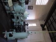
The Goldfields Water Supply Scheme extends in a discontiguous precinct across the 560km linear water pipeline, commencing at Mundaring Weir (1902, 1951) in the Helena Valley and terminating at Mount Charlotte Reservoir (1902) in Kalgoorlie-Boulder. Comprising six extant original Steam Pump Stations (1902) at Mundaring, Cunderdin, Merredin, Yerbillon, Ghooli and Dedari; the sites of two demolished Steam Pump Stations (1902) at O’Connor and Gilgai; Reservoirs and Tanks at O’Connor, Sawyers Valley, Bakers Hill, West Northam, Cunderdin, Merredin, Yerbillon, Ghooli, Bronti, Gilgai, Koorawawalyee, Dedari, Toorak, and Bullabulling; second generation Electric Pump Station at Merredin , and other community sites, ancillary structures; equipment and machinery, archaeological sites; and discontiguous portions of the main pipeline conduit associated with the construction and operation of the Scheme from 1902 to the present.
Phase I - Construction of the Goldfields Water Supply Scheme (1898 - 1903) Phase II – Problem Solving and Agricultural Expansion (1904 - 1940) Phase III – Comprehensive Water Supply Scheme, Upgrades & Refurbishments (1946 - 2013) Phase IV - Heritage Recognition and The Golden Pipeline (1992 - 2011)
High
Good
| Name | Type | Year From | Year To |
|---|---|---|---|
| Charles Yelverton O'Connor | Architect | 1898 | 1902 |
| Library Id | Title | Medium | Year Of Publication |
|---|---|---|---|
| 6452 | Mundaring Weir Precinct masterplan : final master plan report. | Heritage Study {Other} | 2002 |
| 7358 | Conservation plan for Goldfields Water Supply Scheme. Volume II, place M : No. 8 Pumping Station, Dedari. | Heritage Study {Cons'n Plan} | 1999 |
| 11426 | Goldfields Water Supply Volume III | Heritage Study {Cons'n Plan} | 1999 |
| 4897 | Conservation plan for Karalee Rock Water Catchment (Goldfields Water Supply Scheme - place J). | Heritage Study {Cons'n Plan} | 2000 |
| 7359 | Conservation plan for Goldfields Water Supply Scheme. Volume II, place N : Bullabulling reservoir. | Heritage Study {Cons'n Plan} | 1999 |
| 9248 | Constructing Australia: Triumphs and tragedies in building a nation. | C D Rom | 2007 |
| 6390 | Pipe-dream to pipeline : the eventful life of Nathaniel W. Harper. | Book | 2001 |
| 3680 | Conservation plan for No. 3 Pumping Station, Cunderdin. | Heritage Study {Cons'n Plan} | 1998 |
| 1774 | An exploratory bibliography of the Goldfields Water Supply of Western Australia (draft). | Report | 1982 |
| 4504 | Conservation plan for Mount Charlotte Reservoir (Goldfields water supply scheme - place O). | Heritage Study {Cons'n Plan} | 2000 |
| 11762 | Goldfields Water Supply Scheme, Main conduit, Western Australia | Heritage Study {Cons'n Plan} | 2016 |
| 6788 | Conservation plan for Koorarawalyee water catchment and railway station (Draft) (Goldfields Water Supply Scheme - place U). | Heritage Study {Cons'n Plan} | 2001 |
| 9806 | Mundaring Weir water Supply interpretation precinct design. | Book | 2010 |
| 7350 | Conservation plan for West Northam regulating tanks : (Goldfields Water Supply Scheme - place T) (draft). | Heritage Study {Cons'n Plan} | 2001 |
| 7356 | Conservation plan for Goldfields Water Supply Scheme. Volume II, place I : No. 6 Pumping Station, Ghooli. | Heritage Study {Cons'n Plan} | 1999 |
| 7547 | Celebrating 100 years of the Goldfields Water Supply Scheme. | Brochure | 2003 |
| 7354 | Conservation plan for Goldfields Water Supply Scheme. Volume II, place G : No. 4 Pumping Station, Merredin. | Heritage Study {Cons'n Plan} | 1999 |
| 7351 | Conservation plan for Toorak Hill reservoir : (Goldfields Water Supply Scheme - place V) (draft). | Heritage Study {Cons'n Plan} | 2001 |
| 7352 | Conservation plan for Goldfields Water Supply Scheme. Volume II, place A : No. 1 Pumping Station Mundaring. | Heritage Study {Cons'n Plan} | 1999 |
| 7348 | Conservation plan for Sawyers Valley summit tanks : (Goldfields Water Supply Scheme - place R) (draft). | Heritage Study {Cons'n Plan} | 2001 |
| 6675 | Mundaring Weir : conservation plan (draft). | Heritage Study {Cons'n Plan} | 2000 |
| 1608 | Conservation and interpretation plan for No.1 Pumping Station Mundaring. | Heritage Study {Cons'n Plan} | 1996 |
| 5988 | Centenary of the Goldfields Water Supply Scheme 1903-2003. | Brochure | 2003 |
| 7444 | The agricultural areas, Great Southern towns and Goldfields Water Supply Scheme : souvenir to commemorate the completion of the project. | Book | 1961 |
| 10170 | The origins of the Eastern Goldfields water scheme in Western Australia: an exercise in the interpretation of historical evidence. | Book | 1954 |
| 4644 | Conservation plan for Goldfields Water Supply Scheme : volume 1. | Heritage Study {Cons'n Plan} | 1999 |
| 7357 | Conservation plan for Goldfields Water Supply Scheme. Volume II, place K : No. 7 Pumping Station, Gilgai. | Heritage Study {Cons'n Plan} | 1999 |
| 8902 | River of steel. A history of the Western Australian Goldfields and Agricultural Water Supply 1903 - 2003. | Book | 2007 |
| 7355 | Conservation plan for Goldfields Water Supply Scheme. Volume II, place H : No. 5 Pumping Station, Yerbillon. | Heritage Study {Cons'n Plan} | 1999 |
| 7353 | Conservation plan for Goldfields Water Supply Scheme. Volume II, place B : No. 2 Pumping Station, O'Connor. | Heritage Study {Cons'n Plan} | 1999 |
| 7349 | Conservation plan for Bakers Hill regulating tank : (Goldfields Water Supply Scheme - place S) (draft). | Heritage Study {Cons'n Plan} | 2001 |
| 6794 | Conservation plan for Bullabulling township and railway catchment. (draft) : a supplement to the Bullabulling Reservoir conservation plan (Goldfields Water Supply Scheme - place N). | Heritage Study {Cons'n Plan} | 2001 |
| 9899 | Mundaring Weir water supply improvement project: heritage management strategy. | Heritage Study {Other} | 2011 |
| 6326 | The golden pipeline heritage trail guide : a time capsule of water, gold and Western Australia. | Book | 2002 |
| 4693 | Goldfields Water Supply heritage project. | Book | 1999 |
| 5544 | Golden Pipeline interpretation plan. | Heritage Study {Other} | 2001 |
Other Built Type
| Epoch | General | Specific |
|---|---|---|
| Original Use | GOVERNMENTAL | Power Station |
| Present Use | GOVERNMENTAL | Pumping Station |
| Present Use | EDUCATIONAL | Museum |
| Style |
|---|
| Vernacular |
| Type | General | Specific |
|---|---|---|
| Wall | BRICK | Common Brick |
| Wall | METAL | Steel |
| Roof | METAL | Corrugated Iron |
| General | Specific |
|---|---|
| SOCIAL & CIVIC ACTIVITIES | Community services & utilities |
| DEMOGRAPHIC SETTLEMENT & MOBILITY | Technology & technological change |
| DEMOGRAPHIC SETTLEMENT & MOBILITY | Resource exploitation & depletion |
| DEMOGRAPHIC SETTLEMENT & MOBILITY | Exploration & surveying |
This information is provided voluntarily as a public service. The information provided is made available in good faith and is derived from sources believed to be reliable and accurate. However, the information is provided solely on the basis that readers will be responsible for making their own assessment of the matters discussed herein and are advised to verify all relevant representations, statements and information.