Local Government
Bunbury
Region
South West
Outer Harbour Bunbury
E side of Jetty
Bunbury
South West
Constructed from 1880
| Type | Status | Date | Documents |
|---|---|---|---|
| (no listings) |
| Type | Status | Date | Documents |
|---|---|---|---|
| RHP - Does not warrant assessment | Current | 29 Nov 2019 |
| Type | Status | Date | Grading/Management | |
|---|---|---|---|---|
| Category | ||||
| Municipal Inventory | Adopted | 31 Jul 1996 | Historic Site | |
Historic site
| Epoch | General | Specific |
|---|---|---|
| Present Use | VACANT\UNUSED | Vacant\Unused |
| Original Use | SOCIAL\RECREATIONAL | Other |
| Type | General | Specific |
|---|---|---|
| Other | TIMBER | Log |
| General | Specific |
|---|---|
| SOCIAL & CIVIC ACTIVITIES | Sport, recreation & entertainment |
This information is provided voluntarily as a public service. The information provided is made available in good faith and is derived from sources believed to be reliable and accurate. However, the information is provided solely on the basis that readers will be responsible for making their own assessment of the matters discussed herein and are advised to verify all relevant representations, statements and information.
Constructed from 1886
DEMOLISHED Bunbury Public Baths No 1 has historic significance as the site of the first efforts by the Bunbury Municipal Council to provide a safe swimming location for locals and tourists.
DEMOLISHED
Sea baths and dressing rooms were built on the eastern side of Bunbury Timber Jetty in 1886. Two years later, the ‘Southern Advertiser’ described Bunbury as ‘the first town in Western Australia to light its streets with lamps and now stands alone in possessing salt water baths.’ The Bunbury Public Baths were an initiative of the Bunbury Municipal Council to provide safe, salt water swimming baths. The Baths were triangular in shape, fenced to take in just over three acres of sea and land between the jetty approach and the Causeway. From 1902, they were enclosed by a shark proof fence. The Baths provided a recreational facility that was highly regarded by the community and elsewhere. They attracted visitors to Bunbury , especially from the Goldfields during the summer months. In 1907, patrons could hire bathing costumes and towels, as well as purchase refreshments from the Tea Rooms conducted by Mr Dobbins. Circa 1917, the baths were replaced by another bathing pavilion (B027).
DEMOLISHED
DEMOLISHED
This information is provided voluntarily as a public service. The information provided is made available in good faith and is derived from sources believed to be reliable and accurate. However, the information is provided solely on the basis that readers will be responsible for making their own assessment of the matters discussed herein and are advised to verify all relevant representations, statements and information.
Outer Harbour Bunbury
NW side of Henry Street approach to Jetty
Bunbury
South West
Constructed from 1917
| Type | Status | Date | Documents |
|---|---|---|---|
| (no listings) |
| Type | Status | Date | Documents |
|---|---|---|---|
| RHP - Does not warrant assessment | Current | 29 Nov 2019 |
| Type | Status | Date | Grading/Management | |
|---|---|---|---|---|
| Category | ||||
| Municipal Inventory | Adopted | 04 Sep 2001 | ||
| Municipal Inventory | Adopted | 31 Jul 1996 | Historic Site | |
Historic site
| Epoch | General | Specific |
|---|---|---|
| Original Use | SOCIAL\RECREATIONAL | Other |
| Present Use | VACANT\UNUSED | Vacant\Unused |
| Type | General | Specific |
|---|---|---|
| Wall | TIMBER | Other Timber |
| General | Specific |
|---|---|
| SOCIAL & CIVIC ACTIVITIES | Sport, recreation & entertainment |
| SOCIAL & CIVIC ACTIVITIES | Cultural activities |
This information is provided voluntarily as a public service. The information provided is made available in good faith and is derived from sources believed to be reliable and accurate. However, the information is provided solely on the basis that readers will be responsible for making their own assessment of the matters discussed herein and are advised to verify all relevant representations, statements and information.
Constructed from 1917, Constructed from 1930
DEMOLISHED Bunbury Public Baths No 2 and No 3 has historic value as the site of the second and third public baths developed by the Bunbury Municipal Council and demonstrates the Council's ongoing commitment to providing a safe swimming and recreation area for locals and visitors near the centre of Bunbury. It also reflects the growing popularity of Bunbury as a holiday resort in the early to mid 1900s.
DEMOLISHED
The Council appears to have sponsored at least three (3) sets of Jetty Baths enclosures in the Outer Harbour area. The first jetty baths were built c 1886 on the eastern side of the Timber Jetty (See B017). Construction dates are not conclusive and c. 1917 is proposed for the second Jetty Baths. By 1911, Collie Proprietary Coalfields of WA Ltd owned Lot 348 comprising 2a 3r 13p of land. It is speculated that as a great influx of Collie residents chose to make their annual holiday camp on this waterfront land, the baths would have been erected close by. By this time, Bunbury was a very popular holiday resort and experienced a large influx of population during the summer months. A large shark-proofed fenced area, in close proximity to the jetty separated from shipping and other harbour activity thus providing a safe environment for bathers to enjoy their water recreation. Timber pylons support a wooden promenade to three sides of the enclosure. Rows of temporary huts, complete with corrugated tin roofs, formed the "beach" side of the bathing area. Refreshment rooms were also available. Public Baths No. 3 were built on the same site in c 1930, demonstrating the Bunbury Municipal Council's continuing commitment to provide safe swimmimng and recreational facilities for residents and visitors.
DEMOLISHED
DEMOLISHED
This information is provided voluntarily as a public service. The information provided is made available in good faith and is derived from sources believed to be reliable and accurate. However, the information is provided solely on the basis that readers will be responsible for making their own assessment of the matters discussed herein and are advised to verify all relevant representations, statements and information.
Outer Harbour Bunbury
Bunbury
South West
Constructed from 1930
| Type | Status | Date | Documents |
|---|---|---|---|
| (no listings) |
| Type | Status | Date | Documents |
|---|---|---|---|
| RHP - Does not warrant assessment | Current | 29 Nov 2019 |
| Type | Status | Date | Grading/Management | |
|---|---|---|---|---|
| Category | ||||
| Municipal Inventory | Adopted | 31 Jul 1996 | Historic Site | |
| Municipal Inventory | Adopted | 04 Sep 2001 | ||
Historic site
| Epoch | General | Specific |
|---|---|---|
| Present Use | VACANT\UNUSED | Vacant\Unused |
| Original Use | SOCIAL\RECREATIONAL | Other Sports Building |
| Other Use | COMMERCIAL | Shop\Retail Store {single} |
| Type | General | Specific |
|---|---|---|
| Wall | TIMBER | Other Timber |
| General | Specific |
|---|---|
| SOCIAL & CIVIC ACTIVITIES | Cultural activities |
| SOCIAL & CIVIC ACTIVITIES | Sport, recreation & entertainment |
| OUTSIDE INFLUENCES | Tourism |
This information is provided voluntarily as a public service. The information provided is made available in good faith and is derived from sources believed to be reliable and accurate. However, the information is provided solely on the basis that readers will be responsible for making their own assessment of the matters discussed herein and are advised to verify all relevant representations, statements and information.
Constructed from 1930
DELETE THIS ENTRY COMBINED WITH B027 DEMOLISHED Bunbury Public Baths No 3 has historic value as the site of the third public baths developed by the Bunbury Municipal Council and demonstrates the Council's ongoing commitment to providing a safe swimming and recreation area for locals and visitors near the centre of Bunbury. It also reflects the continuing popularity of Bunbury as a holiday resort in the early 1900s.
DEMOLISHED A small, square enclosed area forming public baths. Two jetty arms projected out into Koombana Bay approximately 50 metres, joined by another section at the seaward end, which effectively enclosed an area for swimming. Initially the area was netted to prevent entry by sharks. Later the seaward promanade connection was removed, exposing the swimming area to Koombana Bay. The structure had replaced an earlier bathing area at the same site, west of the timber jetty.
These were the third public baths established by the Bunbury Municipal Council for the use of residents and tourists and demonstrates the commitment of the local government in providing safe swimming and recreational facilities. The Jetty Baths were a focal point of community acitivity. Summer holidaymakers, in particular the annual migration of Collie mining families to "Tent City" near Koombana Bay, took full advantage of the Jetty Public Baths. A kiosk operated on site and change rooms were available for use.
DEMOLISHED
DEMOLISHED
This information is provided voluntarily as a public service. The information provided is made available in good faith and is derived from sources believed to be reliable and accurate. However, the information is provided solely on the basis that readers will be responsible for making their own assessment of the matters discussed herein and are advised to verify all relevant representations, statements and information.
Lot 415 Outer Harbour, Casuarina Pt Bunbury
Bunbury
South West
Constructed from 1897
| Type | Status | Date | Documents |
|---|---|---|---|
| (no listings) |
| Type | Status | Date | Documents |
|---|---|---|---|
| RHP - Does not warrant assessment | Current | 30 Sep 2005 |
| Type | Status | Date | Grading/Management | |
|---|---|---|---|---|
| Category | ||||
| Municipal Inventory | Adopted | 31 Jul 1996 | Exceptional Significance | |
Historic site
| Epoch | General | Specific |
|---|---|---|
| Present Use | Transport\Communications | Water: Dock\Wharf Bldg or Structure |
| Original Use | Transport\Communications | Water: Dock\Wharf Bldg or Structure |
| Style |
|---|
| Other Style |
| Type | General | Specific |
|---|---|---|
| Other | STONE | Local Stone |
| General | Specific |
|---|---|
| TRANSPORT & COMMUNICATIONS | River & sea transport |
This information is provided voluntarily as a public service. The information provided is made available in good faith and is derived from sources believed to be reliable and accurate. However, the information is provided solely on the basis that readers will be responsible for making their own assessment of the matters discussed herein and are advised to verify all relevant representations, statements and information.
Constructed from 1897
Breakwater, Bunbury Harbour, has cultural heritage significance because: it represents an earlier phase of development of Bunbury Harbour; the place has landmark qualities and contributes to the community's sense of place.
Breakwater, Bunbury Outer Harbour is an extension of the natural Basalt formation which ends in Point Casuarina. The breakwater is a wall of stone reaching into the Indian Ocean to provide an area of calm water.
Between 1840 and 1897 twenty nine ships were wrecked in Koombana Bay and understandably, Bunbury Harbour was considered unsafe in the winter months due to the north-west gales. To overcome this, as well as provide protection for ships in the bay and those moored alongside the Bunbury Timber Jetty, a breakwater was built at Casuarina Point in 1897-1900. "Casuarina" was the boat captained by the French explorer Freycinet. Bunbury Timber Jetty was originally constructed in 1864 by convicts and was the first harbour loading facility in Bunbury. William Forrest, the father of Sir John and Alexander, was contracted to build the jetty at a cost of £200. H. W. Gillman, an ex-convict supplied the timber for £339 and the jetty was built with labour from a supervised convict gang who had come from Fremantle. When completed the jetty was 1,400 feet (427m). (See B016.1) In response to the ongoing problem of damaged and wrecked boats in Koombana Bay, C. Y. O’Connor, the Engineer-in-Chief at the Public Works Department, proposed and designed a “Pierres Perdues” type breakwater, following a curve in a north-east direction with approximately a half mile radius. O’Connor had also proposed an inner harbour at this time, but this idea was abandoned. On 27 April 1897, Premier Sir John Forrest tipped the first truck load of stone into the harbour. The breakwater cost £116,705 and was built over three years commencing in 1897. Delays in construction occurred due to a lack of funding and irregular government action. When completed, the breakwater was 3,215 feet (980m) in length. As the timber jetty was extended over the years, so was the breakwater so that it could provide continued protection for ships. Barry & McLaughlin extended the breakwater to 3,969 feet (1,210m) between 1906 and 1908 for a cost of £59,966/6/0. Over the years, there were five extensions - the last completed in 1983 to a final length of 3,200 feet (1,200m). This history is largely based on the Documentary Evidence in Heritage Council of Western Australia, ‘Register of Heritage Places: Bunbury Timber Jetty’, prepared by Natasha Georgio, 1999.
High integrity and authenticity.
Good condition.
This information is provided voluntarily as a public service. The information provided is made available in good faith and is derived from sources believed to be reliable and accurate. However, the information is provided solely on the basis that readers will be responsible for making their own assessment of the matters discussed herein and are advised to verify all relevant representations, statements and information.
Cnr Parkfield & Edward Sts Bunbury
S of Library in Car Park, on site of former Bunbury District Hospital
Araucaria heterophylla
Bunbury
South West
| Type | Status | Date | Documents |
|---|---|---|---|
| (no listings) |
| Type | Status | Date | Documents |
|---|---|---|---|
| (no listings) |
| Type | Status | Date | Grading/Management | |
|---|---|---|---|---|
| Category | ||||
| Municipal Inventory | Adopted | 31 Jul 1996 | Historic Site | |
05669 Bunbury Public Library
Tree
| Epoch | General | Specific |
|---|---|---|
| Present Use | OTHER | Other |
| Original Use | OTHER | Other |
This information is provided voluntarily as a public service. The information provided is made available in good faith and is derived from sources believed to be reliable and accurate. However, the information is provided solely on the basis that readers will be responsible for making their own assessment of the matters discussed herein and are advised to verify all relevant representations, statements and information.
TREE REMOVED The Norfolk Island Pine was planted in the grounds of the Bunbury Hospital c 1900 and was a landmark visible from many parts of the town. For many years, it was decorated with coloured lights as the community Christmas tree.
REMOVED tree removed as part of library redevelopment
Visible from many parts of the city, this prominent tree was planted in the grounds of the Bunbury District Hospital c. 1900. For many years, the tree was decorated with coloured lights and used as the Christmas tree for Bunbury. It would have been appreciated by patients and staff at the hospital, as well as the wider community. In 2001, it was noted that the tree had probably reached maximum height and that the branches were regularly pruned to prevent encroachment on nearby power lines. It appeared healthy and to be thriving. The tree was removed during the building of the new Bunbury City Library c 2009.
tree removed as part of library redevelopment
tree removed as part of library redevelopment
This information is provided voluntarily as a public service. The information provided is made available in good faith and is derived from sources believed to be reliable and accurate. However, the information is provided solely on the basis that readers will be responsible for making their own assessment of the matters discussed herein and are advised to verify all relevant representations, statements and information.
Parkfield St Bunbury
Bunbury Regional Library
Parkfield Hospital, Norfolk Island Pine Tree
Bunbury
South West
Constructed from 1897 to 1958
| Type | Status | Date | Documents |
|---|---|---|---|
| (no listings) |
| Type | Status | Date | Documents |
|---|---|---|---|
| (no listings) |
| Type | Status | Date | Grading/Management | |
|---|---|---|---|---|
| Category | ||||
| Municipal Inventory | Adopted | 31 Jul 1996 | Historic Site | |
05669 Bunbury Public Library
| Name | Type | Year From | Year To |
|---|---|---|---|
| George Temple Poole | Architect | - | - |
| Library Id | Title | Medium | Year Of Publication |
|---|---|---|---|
| 7299 | Bunbury images : people and places. | Book | 2004 |
Historic Site
| Epoch | General | Specific |
|---|---|---|
| Present Use | VACANT\UNUSED | Vacant\Unused |
| Original Use | HEALTH | Hospital |
| Style |
|---|
| Victorian Romanesque |
| Type | General | Specific |
|---|---|---|
| Wall | BRICK | Other Brick |
| General | Specific |
|---|---|
| SOCIAL & CIVIC ACTIVITIES | Community services & utilities |
This information is provided voluntarily as a public service. The information provided is made available in good faith and is derived from sources believed to be reliable and accurate. However, the information is provided solely on the basis that readers will be responsible for making their own assessment of the matters discussed herein and are advised to verify all relevant representations, statements and information.
DEMOLISHED No visible remains except for the original bonded brick walls which currently separate levels of the Council Car Park. The walls separated areas of the Hospital grounds which extended up the steep hilly site along Parkfield Street towards Brend Tor.
DEMOLISHED Van Bremen (1990:317) states that this was the biggest cottage hospital built during the gold boom period. At its opening, it stood on a slight rise [to achieve good prospect, aspect and fresh air], replete with the most modern appliances, contained 53 rooms, and was considered the most important works undertaken by the Government in Bunbury at that time. Forrest himself said that "in old established towns like Bunbury buildings of a temporary character should be put up. The time had come when such towns should have buildings of permanent nature, and with some pretensions to architectural beauty..." Van Bremen (1990:318) writes that the Bunbury hospital design was "an asymmetrical plan expressed in the roof forms and building mass pivoting around the entrance 'tower' This had a half-timbered projecting gable, open colonnade, linking the first floor balcony-verandahs and a large arch over a skewed entrance stair at ground floor level... favourite details of the American Romanesque". She further describes detailed timber verandahs sporting shingle skirt and elegant verandah roofs extending out from the main roof. Bay windows at the end of each large ward became a focal point. these projected a shallow window seat out onto the verandah. A larger bat window extended the dispensary right out into the back garden. Tall brick chimneys were easily depicted against the skyline. Across the full width of the front and around one side, continued the verandah/balcony, which allowed independent access to the bathroom towers at either end. From the wards, French doors opened directly onto the verandahs. The grounds and setting provided a delightful place to convalesce, when coupled with a white picket fence, curved driveway, and attractive tall trees. Van Bremen (1990:319) describes gold boom hospitals as showing "a great deal of architectural character, contextual good manners and grace, contributing something fine to their townscapes while comforting the sick". This example was no exception. Note: there were several extensions to the hospital during its lifetime, including a concrete wing in 1958.
Located on Stephen Street, near the edge of the lagoon, Bunbury's first hospital was established as part of the Convict Depot. Over the years, Bunbury was also served by many private hospitals which were, in the main, part owned, operated and managed by nursing sisters. There was no government hospital in Bunbury until the late 1890s when land was purchased from William Spencer for the purpose. G T Poole, chief architect with the public works department, drew up the plans in 1895 and the tender was awarded to Wallis and Boundy in July 1896. On 15 March 1897, the Premier, Sir John Forrest, laid the foundation stone for the new Bunbury Government Hospital as part of the celebrations for Queen Victoria's jubilee. Forrest stated, 'It must be remembered that the hospitals of the colony were not intended for those who were well off except in some exceptional case of accident or serious illness.' He thought no well-to-do person should enter the building as a patient as they were primarily intended for the poor. When the hospital opened in 1897 it was described as 'situated in a most picturesque locality... and its design will make it an architectural ornament to the town'. With 53 rooms, Bunbury Government Hospital was the largest cottage hospital built during the Gold Boom period. It stood on a slight rise to achieve good aspect and fresh air and, replete with modern appliances, was considered the most important Government work undertaken in Bunbury to that time. Dr David Ernest Williams was the first resident medical and health officer and Matron Ashton managed both patients and nursing staff. At the time, the Government paid £100 per annum towards the salary of the resident medical officer in each public hospital, together with a £ for £ subsidy on all public subscriptions raised. The government also contributed £1/5/0 per week per head towards the requirements of indigent patients. Over the years, the staff dealt with epidemics of smallpox, influenza and typhoid, as well as issues related with poverty. Public hospital maternity patients were accommodated in the nearby Stirling Street Maternity Hospital (see B159) and transferred to the main hospital if surgical procedures were necessary. During the latter years, a private residence in Stirling Street (Oakley Home- now demolished) was converted to serve as an aged care annexe to the Government Hospital. There were several extensions to the hospital during its lifetime, including a concrete wing in 1958. Bunbury Government Hospital was demolished in 1967. the foundation stone, laid by Sir John Forrest in 1897, is now located at South West Health Campus Regional Hospital. The Bunbury Regional Hospital (B013) was built as a replacement. This was demolished in 2000 when the South West Health Campus Regional Hospital opened. Bunbury Public Library was built on the site in 1974. That library has since been demolished and replaced with a new building (2009; see B117).
DEMOLISHED
No visible remains except for original bonded brick walls which currently seperate levels of the Council Car Park. the walls seperated areas of the Hospital grounds which extended up the steep hilly site along Parkfield Street towards Brend Tor.
| Name | Type | Year From | Year To |
|---|---|---|---|
| Temple Poole, George | Architect | - | - |
| Reserve | Lot/Location | Plan/Diagram | Vol/Folio |
|---|---|---|---|
| 1 | P038215 100 | VOL2550FOL963 |
This information is provided voluntarily as a public service. The information provided is made available in good faith and is derived from sources believed to be reliable and accurate. However, the information is provided solely on the basis that readers will be responsible for making their own assessment of the matters discussed herein and are advised to verify all relevant representations, statements and information.
18 Parkfield St Bunbury
Bunbury
South West
| Type | Status | Date | Documents |
|---|---|---|---|
| Heritage List | Adopted | 15 Apr 2003 |
| Type | Status | Date | Documents |
|---|---|---|---|
| (no listings) |
| Type | Status | Date | Grading/Management | |
|---|---|---|---|---|
| Category | ||||
| Municipal Inventory | Adopted | 31 Jul 1996 | Historic Site | |
00345 Catholic Cathedral Precinct, Bunbury
Individual Building or Group
| Epoch | General | Specific |
|---|---|---|
| Original Use | RELIGIOUS | Church, Cathedral or Chapel |
This information is provided voluntarily as a public service. The information provided is made available in good faith and is derived from sources believed to be reliable and accurate. However, the information is provided solely on the basis that readers will be responsible for making their own assessment of the matters discussed herein and are advised to verify all relevant representations, statements and information.
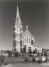
Constructed from 1967, Constructed from 1921
DEMOLISHED St Patrick's Roman Catholic Cathedral was an important focus for community, social and religious activity.
DEMOLISHED
St Patrick’s Roman Cathedral was built on Bury Hill as a parish church. Bury Hill is now referred to as Cathedral Hill. The parish church was designed by architect Richard J Dennehy. Dennehy was born in Ireland in 1859 and arrived in Western Australia in 1896. He designed an impressive gothic building in brick stucco and tile. The foundation stone was laid on the 14 November 1920 by Monsignor P. Verling and the church was dedicated on 27 November 1921 by the Archbishop of Perth, Rev, P. J. Clune. Archdeacon L. J. Smyth[e] was the main driving force behind the building of the cathedral. On the opening day he referred to it as ‘the Cathedral-to-be of a future diocese.’ His vision came true on 12 November 1954, when the parish church official became the Cathedral for the Catholic Diocese of Bunbury. Additions including a tower and 40 foot (12 metre) high spire were added to the Cathedral in 1967. The spire completed an original design concept for the building – the original spire planned for the parish church was lost in the Bay of Biscay before the church was built. The entrance was modeled on St Paul’s Cathedral in Melbourne and the main structure was a close copy of St Brigid’s in Perth. The Cathedral, with its new additions, was rededicated on 12 March 1967 by the Bishop of Bunbury, the Most Rev L J Goody. With the additions, the Cathedral could now seat 700 people. On 25 September 1983, memorial windows dedicated to the memory of former mayor, Pat Usher, were unveiled. The windows were a triptych of stained glass designed by Ian Richardson. Brass doors inscribed with Jubilee 2000 were installed to commemorate the year 2000. They replaced earlier wooden entrance doors. On 16 May 2005, a tornado so badly damaged the Cathedral that it had to be demolished. The Church compiled a photographic record of the building prior to demolition. Plans for a new cathedral were prepared by architect Marcus Collins in 2007 following extensive public consultation. The overwhelming call was for ‘an iconic Cathedral centred on the same axis as Victoria Street with a traditional exterior and modern interior.’ Construction commenced in 2009/10. The new St Patrick's Cathedral was completed by 2011 and dedicated on 17th March 2001 by Bishop Gerard Holohan, the fourth Bishop of Bunbury.
DEMOLISHED
DEMOLISHED
This information is provided voluntarily as a public service. The information provided is made available in good faith and is derived from sources believed to be reliable and accurate. However, the information is provided solely on the basis that readers will be responsible for making their own assessment of the matters discussed herein and are advised to verify all relevant representations, statements and information.
2-14 Parkfield St Bunbury
Bunbury
South West
Constructed from 1974
| Type | Status | Date | Documents |
|---|---|---|---|
| (no listings) |
| Type | Status | Date | Documents |
|---|---|---|---|
| (no listings) |
| Type | Status | Date | Grading/Management | |
|---|---|---|---|---|
| Category | ||||
| Municipal Inventory | Adopted | 31 Jul 1996 | Some Significance | |
Individual Building or Group
| Epoch | General | Specific |
|---|---|---|
| Present Use | EDUCATIONAL | Library |
| Original Use | EDUCATIONAL | Library |
| Type | General | Specific |
|---|---|---|
| Wall | BRICK | Common Brick |
| Roof | TILE | Other Tile |
| General | Specific |
|---|---|
| SOCIAL & CIVIC ACTIVITIES | Education & science |
This information is provided voluntarily as a public service. The information provided is made available in good faith and is derived from sources believed to be reliable and accurate. However, the information is provided solely on the basis that readers will be responsible for making their own assessment of the matters discussed herein and are advised to verify all relevant representations, statements and information.
Constructed from 2009, Constructed from 1974
Bunbury Public Libary has cultural heritage significance for the following reasons: library services for the Bunbury community have been provided on this site since 1974; the place provides a focus for community learning and cultural activities.
A new brick and glass library building was constructed on the site in 2009. Bench seats in landscape areas have been constructed from the significant Norfolk Island Pine Tree that was removed from the site.
Bunbury Public Library was completed in 2009 and stands on the site of an earlier public library, which was completed in 1974. The first libraries in Western Australia were established in 1851 by the Swan River Mechanics Institute and the Fremantle Mechanics Institute. The first public library was the Victoria Public Library (now the State Library of Western Australia), which was established in 1887. Dr James Battye, State Librarian from 1894 to 1954, was instrumental in the development of public libraries throughout the State. In 1945 the State Government set up a Country Free Lending Library Committee with Battye as the Chairman. The committee was authorised to give £1 for £1 cash subsidies to local authorities for the purchase of ‘books of a broad educational character.’ They also acted as a central buying committee for the books brought with the government subsidy. Although not initially successful, the scheme was fundamental in involving and getting government support for local libraries and it demonstrated that more money was needed to produce an effective public library service. A parliamentary bill proposing to set up a board to develop cash subsidized public libraries was rejected in 1948. Another bill, giving wider powers to the proposed board, as passed in 1951. The principle function of the Library Board was to encourage local authorities to establish free public libraries; to co-ordinate those libraries into a state wide scheme, to offer a £1 for £1 subsidy for the establishment of libraries, and lastly, to provide training for library staff. The main purpose of public libraries was to provide various print materials for the community so that they could ‘derive to the fullest extent of their own needs or desires the information, enrichment and delight which is to be had from books and other printed materials.’ Other aims included encouraging and promoting the use of books and to provide information on any subject which might be called upon by the public. As early as 1903 Bunbury had a municipal library which appears to have been a fee based circulating library. However, it was not until 1970 that a branch of the State Library was seriously proposed for Bunbury. A ratepayers meeting in that year opposed Council plans for a library and six-storey administration block on the old Government Hospital site in Parkfield Street. However, the matter was resolved when the public voted in a loan poll for a two storey library building. Bunbury Public Library was officially opened on 16 November 1974 by the State Librarian, Francis Aubie Sharr. It was a big civic occasion, with Mayor Pat Usher taking control of proceedings. Bunbury Public Library was a two storey brick, iron and tile building with north facing floor length windows giving views across Anzac Park. Roof leakages caused concern for paper based stock over the years. At some stage, an addition was built to the south west corner for the storage of archival materials. A second public library at Withers was opened in 1985 to meet demands created by increased membership due to residential growth in the southern corridors of Bunbury. The first Bunbury Public Library was demolished in 2007 to make way for a new building designed by Peter Hunt Architect and built by CIMECO. The new library, occupying the footprint of the original building, is a two level steel framed, glass veiled structure. The new Bunbury City Library was opened on 3 February 2009 with the main aims of providing an information service to the people of Bunbury, as well as promoting informal education as a lifelong process. In 2009, the new library received a commendation from the Australian Institute of Architects for Public Architecture (Western Australia). A Norfolk Island Pine Tree, which had been planted as part of the hospital grounds c 1900, had been the town Christmas Tree for many years. Each year, the tree was decorated with coloured lights and was appreciated by patients and staff at the hospital, as well as the wider community. The tree was removed during the construction of the new Bunbury City Library and its timber was used to fabricate benches which are located in the library forecourt. Interpretive panels and a mural were installed in the ground floor public space of the library in 2011.
Condition assessed as good (assessed from streetscape survey only).
| Name | Type | Year From | Year To |
|---|---|---|---|
| Hobbs, Winning & Leighton (1974 building) | Architect | - | - |
| Reserve | Lot/Location | Plan/Diagram | Vol/Folio |
|---|---|---|---|
| 512 | P174228 512 | VOL1748FOL671 |
This information is provided voluntarily as a public service. The information provided is made available in good faith and is derived from sources believed to be reliable and accurate. However, the information is provided solely on the basis that readers will be responsible for making their own assessment of the matters discussed herein and are advised to verify all relevant representations, statements and information.
29-33 Parkfield St Bunbury
Cnr Cross St This P number was given Cat 2 RC 16/04/04 with recommendation to expand curtilage to include Bishopscourt accross the road.
Calvary Wayside Shrine & Memorial Lawn
Bunbury
South West
Constructed from 1961
| Type | Status | Date | Documents |
|---|---|---|---|
| Heritage List | Adopted | 15 Apr 2003 |
| Type | Status | Date | Documents |
|---|---|---|---|
| (no listings) |
| Type | Status | Date | Grading/Management | |
|---|---|---|---|---|
| Category | ||||
| Municipal Inventory | Adopted | 31 Jul 1996 | Exceptional Significance | |
18566 St Boniface Anglican Cathedral & Bishopscourt
| Name | Type | Year From | Year To |
|---|---|---|---|
| L.R. Williams (Melbourne) | Architect | - | - |
| Library Id | Title | Medium | Year Of Publication |
|---|---|---|---|
| 10236 | St Boniface Cathedral | Brochure | 0 |
| 11488 | St Boniface Anglican Cathedral | Heritage Study {Cons'n Plan} | 2013 |
Individual Building or Group
| Epoch | General | Specific |
|---|---|---|
| Present Use | RELIGIOUS | Church, Cathedral or Chapel |
| Original Use | RELIGIOUS | Church, Cathedral or Chapel |
| Style |
|---|
| Post-War Ecclesiastical |
| Type | General | Specific |
|---|---|---|
| Wall | BRICK | Common Brick |
| Other | METAL | Bronze |
| Other | TIMBER | Other Timber |
| General | Specific |
|---|---|
| SOCIAL & CIVIC ACTIVITIES | Religion |
This information is provided voluntarily as a public service. The information provided is made available in good faith and is derived from sources believed to be reliable and accurate. However, the information is provided solely on the basis that readers will be responsible for making their own assessment of the matters discussed herein and are advised to verify all relevant representations, statements and information.
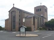
Constructed from 1961
St Boniface Anglican Cathedral, a double volume yellow face brick church with a gabled terracotta tiled roof, a parapeted tower and an undercroft crypt, designed in the Post War Ecclesiastical has cultural heritage significance for the following reasons: the place was the first Anglican cathedral to be built and consecrated in Western Australia in the 20th century; the place is a landmark in its elevated position on Brent Tor, one of the highest sites in Bunbury; the place is an outstanding example of the Post-War Ecclesiastical style of architecture and is a fine example of the work of prominent ecclesiastical architect Louis Williams; the place is highly values by the Anglican and wider community, especially that of the Diocese of Bunbury, for its religious, cultural and social reasons; the place is an integral part of an important precinct of ecclesiastical buildings on the outskirts of the central Bunbury area and contributes to the community's sense of place as significant symbols of the growth and development of Bunbury; and the place is associated with Bishop Frederick Goldsmith, with the Brotherhood of St Boniface and the Order of St Elizabeth of Hungary, and the successive bishops of Bunbury; the Calvary Wayside Shrine and Memorial Lawn are important elements on the site.
St Boniface Anglican Cathedral is a double volume yellow face brick church with a gabled terracotta tiled roof, a parapeted tower and an undercroft crypt, designed in the Post War Ecclesiastical style of architecture. There is a gabled double height main entrance porch with a pair of ledge and braced doors with a tall highlight window over recessed into the porch between a pair of wide brick piers. Adjacent to the porch are four tall windows with stone mullions and transoms. Stained glass memorial windows are in place. The Calvary Wayside Shrine is a timber cross mounted with a brass statue of the crucified Christ located in the centre of the Memorial Lawn.
St Boniface Anglican Cathedral was built in 1962. It was a replacement for St Paul’s Pro-Cathedral on Victoria Street, which had been built in 1866. St Paul’s was demolished in 1963. (See B221) The first church in Bunbury, which also served as a school, was on the site of the St Paul’s Pro-Cathedral and was a standard building rented for £25 a year from the Australind Surveyor, Thomas Thompson. (The land was later acquired from Thompson.) The first service was held on 29 December 1844. St Paul’s was named a Pro-Cathedral in 1903 as part of Bunbury becoming a Diocese of the Anglican Church in 1904. The last service was held in St Paul’s in October 1962. There had been talk of a building a ‘worthy cathedral’ in Bunbury since it became a Diocese but finance continued to be a problem for many years. A cathedral building fund was commenced in 1911 and in 1916, the Church bought land from George Rose. During World War I, Bishop Goldsmith stated that he hoped the cathedral might be built as ‘a Great War Memorial … No more worthy project can we have for a memorial to the brave men of whom the war has robbed us …’ However, failure to progress the building of the cathedral led to Goldsmith’s resignation and although his successor, Bishop Wilson, also promoted the building of a cathedral proper, the project flagged until Bishop Knight was appointed in 1938. Again, little progress was made until after World War II and immediately after Bishop Redding was enthroned at Bunbury in 1951, he stated that the time had come for Bunbury to have a cathedral. Synod gave approval for the preparation of plans in 1952. Preliminary work was started in April 1955 and building began in 1961. The architect was Louis Williams of Victoria assisted by Western Australian architect Robert Blatchford. Williams prepared designs for a modern Gothic structure, which was built by Jennings Constructions Ltd for the contract price of £91,116. Governor Sir Charles Gardiner laid the foundation stone on 15 October 1961 and the building was completed in November 1962. When the Cathedral was consecrated on 14 October 1962, it had the honour of being the first Anglican Cathedral to be consecrated in Western Australia in the twentieth century. The cathedral contains 410,000 standard bricks, 8,000 special bricks, 75,000 roof tiles, and 700 tons of concrete. The timber includes 24,000 feet of blackbutt for the nave ceiling and 200 square yards of blackbutt floor parquetry. The chapel contains adornments which were previously located in St David’s in Spencer Street, (demolished 1960s) (See B048) and St Paul’s (B221) (both demolished) and the chapel is dedicated to both of these saints. Gifts to the new cathedral included stained glass windows, gold chalice and ciborium, Silver Star of Bethlehem crucifix, candlesticks, a Bishop’s throne, altar, pulpit and clock tower. The clock was made and installed by Cannon Davies who was a priest of the Diocese. Also inside the cathedral is a 15th or 16th century carved panel of St John the Baptist. The Cathedral also contains a consecrated stone from St Paul’s Pro-Cathedral and another consecrated stone from a 12th century church at Bunbury, Cheshire, England, which had been built by Norman Conquerors. The Cathedral was named for the Brotherhood of St Boniface, which was established by the first Bishop of Bunbury. The Brotherhood was named after St Boniface who was born in 674AD and was an Archbishop, an apostle, the Patron Saint of Germany and also the Patron Saint of the diocese of Exeter, England. He was matyred in 745AD at the age of 80. There are several churches and cathedrals around the world named St Boniface. As it was intended to be a memorial to the war dead of World War I and World War II, St Boniface Cathedral is commonly referred to as a ‘war memorial cathedral’. Contemporary newspaper reports also referred to it as the 'Church of England War Memorial Cathedral'. However, there is no mention of it being a war memorial in its name or on site. An Anglican Calvary Wayside Shrine was built in the grounds of the Sister of Elizabeth of Hungary Convent, at the corner of Spencer Street and Clarke Street, in 1938. The Order of Sister of Elizabeth of Hungary was founded in London as an offshoot of the Confraternity of Divine Love in 1916. Both were founded by Reverend Mother Elizabeth (Elizabeth Hodges) and the Order was named for the 13th century saint and princess Elizabeth of Hungary (Elizabeth of Thuringia). The Western Australian Chapter was set up to provide “spiritual encouragement” to young English women, in particular those who had come out as part of group settlements. The Sisters arrived in Bunbury in March 1928 and soon established houses at Margaret River and Busselton. They raised funds for small churches to be built in the group settlements. The Sisters lived their lives according to the Franciscan tradition and wore a habit of grey which resulted in them being referred to as St Francis's "little grey sparrows." As well as providing support for the group settlers of the 1930s, they comforted many in the community through the Great Depression and World War Two. The Sisters also helped the Clergy with parish duties, ran a Correspondence Sunday School throughout the Great Southern and operated a hostel which offered inexpensive board to country girls attending high school in Bunbury. In 1954, the Sisters sold the hostel and their Busselton house and in 1957 they withdrew from Western Australia. One of the reasons given for their withdrawal was that their work with the English amongst the group settlers was finished. The shrine consisted of a crucifix, provided by the Confraternity of Divine Love, and a cross made by Mr Gregory, a skilled carpenter and neighbour. During World War II, Italian prisoners of war detained at nearby Hands Oval paid homage at the Calvary Shrine as they marched past on work detail. In the mid-1950s, the Calvary Shrine was relocated to the grounds of St Boniface Cathedral in a memorial lawn setting. The memorial and commemorative wall, built by J M Best to a design prepared by Forbes and Fitzhardinge Architects, was unveiled by Bishop Donald Redding, the fourth Bishop of Bunbury, in 1956. The commemorative wall is designed to hold plaques celebrating the lives of people associated with the Bunbury Diocese of the Anglican Church. In 2010 the place was included in the State Register of Heritage Places.
High degree of integrity (original intent clear, current use compatible, high long term sustainability). High degree of authenticity with much original fabric remaining. (These statements based on street survey only).
Condition assessed as good (assessed from streetscape survey only).
| Reserve | Lot/Location | Plan/Diagram | Vol/Folio |
|---|---|---|---|
| 18 | P003610 18 |
This information is provided voluntarily as a public service. The information provided is made available in good faith and is derived from sources believed to be reliable and accurate. However, the information is provided solely on the basis that readers will be responsible for making their own assessment of the matters discussed herein and are advised to verify all relevant representations, statements and information.
31 & 33 Parkfield St Bunbury
Lots 6-8 Oakley Street, Lot 20 Cross Street, and 15 Cross Street; all in Bunbury.
Bunbury
South West
Constructed from 1905, Constructed from 1962
| Type | Status | Date | Documents |
|---|---|---|---|
| State Register | Registered | 29 Oct 2010 | HCWebsite.Listing+ListingDocument, HCWebsite.Listing+ListingDocument |
| Type | Status | Date | Documents |
|---|---|---|---|
| (no listings) |
| Type | Status | Date | Grading/Management | |
|---|---|---|---|---|
| Category | ||||
| Municipal Inventory | Adopted | 04 Sep 2001 | Retain & conserve if possible | |
| Name | Type | Year From | Year To |
|---|---|---|---|
| Williams, Louis | Architect | - | - |
| Ochiltree, J.L. | Architect | - | - |
| Steere, Frederick Walter | Architect | - | - |
| Library Id | Title | Medium | Year Of Publication |
|---|---|---|---|
| 11488 | St Boniface Anglican Cathedral | Heritage Study {Cons'n Plan} | 2013 |
| 10236 | St Boniface Cathedral | Brochure | 0 |
Individual Building or Group
| Epoch | General | Specific |
|---|---|---|
| Present Use | RELIGIOUS | Church, Cathedral or Chapel |
| Original Use | RELIGIOUS | Church, Cathedral or Chapel |
| Present Use | RELIGIOUS | Housing or Quarters |
| Original Use | RELIGIOUS | Housing or Quarters |
| Style |
|---|
| Post-War Ecclesiastical |
| Federation Queen Anne |
| Type | General | Specific |
|---|---|---|
| Wall | BRICK | Face Brick |
| Roof | TILE | Terracotta Tile |
| General | Specific |
|---|---|
| DEMOGRAPHIC SETTLEMENT & MOBILITY | Settlements |
| SOCIAL & CIVIC ACTIVITIES | Religion |
| DEMOGRAPHIC SETTLEMENT & MOBILITY | Immigration, emigration & refugees |
This information is provided voluntarily as a public service. The information provided is made available in good faith and is derived from sources believed to be reliable and accurate. However, the information is provided solely on the basis that readers will be responsible for making their own assessment of the matters discussed herein and are advised to verify all relevant representations, statements and information.
This information is provided voluntarily as a public service. The information provided is made available in good faith and is derived from sources believed to be reliable and accurate. However, the information is provided solely on the basis that readers will be responsible for making their own assessment of the matters discussed herein and are advised to verify all relevant representations, statements and information.
Parkfield St, Bury Hill Bunbury
Bunbury
South West
Constructed from 1841 to 1926
| Type | Status | Date | Documents |
|---|---|---|---|
| (no listings) |
| Type | Status | Date | Documents |
|---|---|---|---|
| (no listings) |
| Type | Status | Date | Grading/Management | |
|---|---|---|---|---|
| Category | ||||
| Municipal Inventory | Adopted | 31 Jul 1996 | Historic Site | |
| Municipal Inventory | Adopted | 31 Jul 1996 | ||
Demolished.
| Library Id | Title | Medium | Year Of Publication |
|---|---|---|---|
| 7299 | Bunbury images : people and places. | Book | 2004 |
Historic Site
| Epoch | General | Specific |
|---|---|---|
| Other Use | GOVERNMENTAL | Government Residence |
| Original Use | RESIDENTIAL | Single storey residence |
| Present Use | VACANT\UNUSED | Vacant\Unused |
| Style |
|---|
| Victorian Georgian |
| Victorian Colonial |
| Type | General | Specific |
|---|---|---|
| Wall | RENDER | Roughcast |
| Wall | TIMBER | Weatherboard |
| Roof | TIMBER | Shingle |
| General | Specific |
|---|---|
| DEMOGRAPHIC SETTLEMENT & MOBILITY | Settlements |
| DEMOGRAPHIC SETTLEMENT & MOBILITY | Land allocation & subdivision |
| OCCUPATIONS | Domestic activities |
| OUTSIDE INFLUENCES | Water, power, major t'port routes |
This information is provided voluntarily as a public service. The information provided is made available in good faith and is derived from sources believed to be reliable and accurate. However, the information is provided solely on the basis that readers will be responsible for making their own assessment of the matters discussed herein and are advised to verify all relevant representations, statements and information.
Constructed from 1882, Constructed from 1841
DEMOLISHED Bury Hill has historic significance as the site of one of the first houses in Bunbury. It was built by then Resident Magistrate, George Eliot on a prominent location overlooking Koombana Bay. The house and area were called Bury Hill as the area was known to be an Aboriginal burial ground. The resident magistrate was an important figure in regional communities. The house was subsequently used by other resident magistrates before becoming the first St John of God Hospital in Bunbury.
DEMOLISHED
Bury Hill was built by George Eliot, the Resident Magistrate for the District of Wellington, in 1841 as his private and business residence. He had been appointed by Governor James Stirling on 20 January 1841. After the Clifton family arrived in Western Australia in 1841 with the WA Company to settle at Australind, Louisa Clifton sketched Bury Hill prior to disembarking. The following year, she married George Eliot at Bury Hill and together they raised their growing family at “Government House” before leaving for Geraldton. Louisa, an accomplished artist, sketched local scenes from the vernadah of the house. “Government House” was a simple Georgian house which Louisa Clifton described as ‘crude and rough in its construction, thatched and very simply furnished’. A large timer addition was completed at some stage. The house and land (comprising 20 acres, bounded by Stirling Street, Lovegrove Avenue and King’s Table (Boulter’s Heights) was put up for sale in September 1871. William Spencer, a local businessman, purchased the property the following year for £4,000. The sale prompted much correspondence between Eliot and Spencer, as it cause great inconvenience to the sitting tenant, Dr Thomas Lovegrove (Eliot’s son in law). By 1882, William Spencer had demolished part of the original house and built a large, single storey brick and iron bungalow in front of the remaining building. The two were connected by a breezeway. The new house featured a delicate timber valance and verandah wrapping around at least three sides, supported on slender timber posts. In March 1883, part of the land was subdivided for sale. Further allotments with frontages to Zoe Street and Vasse Road (now Spencer Street) were sold by auction in 1888. Circa 1913, the property was purchased by the Hon Edwin Rose and in 1927, the house was purchased by the Sisters of St John of God for conversion into a hospital. The hospital opened on 11 December 1927. Part of the hospital (former Spencer/Rose home) was demolished in 1940 when a maternity wing was added to the St John of God Hospital. The remainder of the house was demolished when further additions to the hospital was undertaken in 1972. By 1986, the hospital had 125 beds and provided surgical, medical, pediatric and emergency care. The hospital closed when St John of God Hospital relocated to the South West Health Campus in 1999. The area was also known as Bury Hill.
DEMOLISHED
DEMOLISHED
| Reserve | Lot/Location | Plan/Diagram | Vol/Folio |
|---|---|---|---|
| 1 | P038215 100 | VOL2550FOL963 |
This information is provided voluntarily as a public service. The information provided is made available in good faith and is derived from sources believed to be reliable and accurate. However, the information is provided solely on the basis that readers will be responsible for making their own assessment of the matters discussed herein and are advised to verify all relevant representations, statements and information.
13-19 Pickersgill St Bunbury
Cnr Pickersgil St & Roberts Cr
Bunbury
South West
Constructed from 1967
| Type | Status | Date | Documents |
|---|---|---|---|
| (no listings) |
| Type | Status | Date | Documents |
|---|---|---|---|
| (no listings) |
| Type | Status | Date | Grading/Management | |
|---|---|---|---|---|
| Category | ||||
| Municipal Inventory | Adopted | 31 Jul 1996 | Some Significance | |
| Municipal Inventory | Adopted | 04 Sep 2001 | ||
Individual Building or Group
| Epoch | General | Specific |
|---|---|---|
| Present Use | Transport\Communications | Comms: Radio or Television Station |
| Original Use | Transport\Communications | Comms: Radio or Television Station |
| Style |
|---|
| Late 20th-Century International |
| Type | General | Specific |
|---|---|---|
| Wall | BRICK | Common Brick |
| Other | GLASS | Glass |
This information is provided voluntarily as a public service. The information provided is made available in good faith and is derived from sources believed to be reliable and accurate. However, the information is provided solely on the basis that readers will be responsible for making their own assessment of the matters discussed herein and are advised to verify all relevant representations, statements and information.
Constructed from 1967
GWN Televison Studio has cultural heritage significance for the following reasons: it is an important regional facility which boosts and promotes the local economy. GWN Network is a modern communication and television studio which outreaches throughout regional Western Australia. At the time of establishment, such a facility represented an important confidence booster and faith in Bunbury as a regional centre.
GWN Television Studio is a modern building with an expanse of reflective glass cladding forming truncated walls at the corner of Pickersgill Street and Simpson Avenue. The station logo/business sign is prominent on the truncated wall of the building.
BTW3 Studios were built in the mid-1960s at a cost of $500,000. The commercial studios were opened on 10 March 1967. The studios were opened by Governor Sir Douglas Kendrew who warned people not to let television rule their lives. He also commented that the station had the youngest staff in the country and that great things were expected of them. In all there were 16 staff members who would televise for 30 hours a week until revenue improved. H. R. Goldings, the Chairman of Directors said that BTW3 would relay station GSW9 and serve 126,000 people in 39,624 homes. The station planned to telecast high quality programs with an emphasis on district news. The opening was the stations first live broadcast and in attendance was the Federal Shipping and Transport Minister G. Freeth, Australian Broadcaster Control Board representative J. Donovan and station manager B. Hopwood. At this time, the BTW3 was the State's second regional broadcaster – ABC first broadcast to regional Western Australia in May 1965. The decision for South West Telecasters to locate their headquarters and studios in Bunbury provided a substantial boost to the status and confidence of the town as a regional centre. In 1979, BTW3 became the Golden West Network (GWN). As the centre of operations for this regional network that operates throughout a large portion of Western Australia, Bunbury continues to be promoted directly and indirectly through GWN. GWN was the only commercial regional broadcaster in Western Australia until 1991, when WIN Television arrived. Local Radio West Broadcasting Studios have been located in the building since the 1990s.
High degree of integrity (original intent clear, current use compatible, high long term sustainability). High degree of authenticity with much original fabric remaining. (These statements based on street survey only).
Condition assessed as good (assessed from streetscape survey only).
| Reserve | Lot/Location | Plan/Diagram | Vol/Folio |
|---|---|---|---|
| 27 | P007964 27 | VOL1281FOL140 |
This information is provided voluntarily as a public service. The information provided is made available in good faith and is derived from sources believed to be reliable and accurate. However, the information is provided solely on the basis that readers will be responsible for making their own assessment of the matters discussed herein and are advised to verify all relevant representations, statements and information.
Cnr Pickersgill, Acacia & Sherry Sts Bunbury
Bunbury Senior High School Hostel
Bunbury
South West
Constructed from 1952
| Type | Status | Date | Documents |
|---|---|---|---|
| (no listings) |
| Type | Status | Date | Documents |
|---|---|---|---|
| (no listings) |
| Type | Status | Date | Grading/Management | |
|---|---|---|---|---|
| Category | ||||
| Municipal Inventory | Adopted | 31 Jul 1996 | Historic Site | |
| Municipal Inventory | Adopted | 04 Sep 2001 | ||
Historic Site
| Epoch | General | Specific |
|---|---|---|
| Present Use | VACANT\UNUSED | Vacant\Unused |
| Original Use | EDUCATIONAL | Housing or Quarters |
| Style |
|---|
| Other Style |
| Type | General | Specific |
|---|---|---|
| Wall | CONCRETE | Reinforced Concrete |
| Wall | TIMBER | Weatherboard |
| Wall | BRICK | Rendered Brick |
This information is provided voluntarily as a public service. The information provided is made available in good faith and is derived from sources believed to be reliable and accurate. However, the information is provided solely on the basis that readers will be responsible for making their own assessment of the matters discussed herein and are advised to verify all relevant representations, statements and information.
Constructed from 1952, Constructed from 1965
DEMOLISHED Craig House was built in response to the prominence of Bunbury as a regional centre for Secondary Education. The Country Women's Association set up and administered the facility where students from all around the South West could live and board during their years at Bunbury Senior High School.
DEMOLISHED
The State Government built ‘Craig House’ as a boarding house for girls and boys attending Bunbury High School. It was managed by the Country Women’s Association. The Government had earlier established a girls’ hostel opposite the High School in February 1952. Prior to this, the Sisters of St Elizabeth of Hungary had provided boarding for some female students at their Mary Clementina Hostel in Clarke Street. The Sisters’ hostel closed in the early 1950s when they withdrew from Bunbury. Boys initially boarded at Sandridge Park (1945-1948) and then the old Goldfields Fresh Air League building (called ‘Craig House’). The CWA managed both government hostels. Originally designed for twelve students, there were 48 residents in the girls’ hostel by 1958. By 1963, plans were in hand to build a modern hostel to accommodate both girls and boys. Building was completed in 1965 at a cost of £130,000 with the capacity for 96 students. The new Craig House comprised four separate buildings, connected by a covered patio. One block housed the boys’ dormitories, another for the girls, a third held the dining, kitchen and storerooms and the fourth was the recreation room. The edifice was often referred to as ‘Alcatraz’, probably as much a comment on how it was managed as its regular geometrical design, featuring a flat roof, bare white concrete walls relived only by shafts of small windows and little other embellishment. However, rapidly changing patterns of State education progressively reduced the number of students who needed to board away from home. Impacting factors included expanded bus services and the provision of more junior high schools in country towns. In 1966, Craig Hostel housed 41 students and was running at a heavy loss. It closed in 1969, ending a thirty year relationship between the government and the CWA in the provision of boarding accommodation in Bunbury. Changing economic conditions in the country led the Government to re-open Craig House Student Hostel in 1972. It is not known when it closed again. Craig Hostel was demolished c 1991.
DEMOLISHED
No visible remains.
This information is provided voluntarily as a public service. The information provided is made available in good faith and is derived from sources believed to be reliable and accurate. However, the information is provided solely on the basis that readers will be responsible for making their own assessment of the matters discussed herein and are advised to verify all relevant representations, statements and information.
16 Picton Cr Bunbury
Bunbury
South West
Constructed from 1920
| Type | Status | Date | Documents |
|---|---|---|---|
| Heritage List | Adopted | 15 Apr 2003 |
| Type | Status | Date | Documents |
|---|---|---|---|
| (no listings) |
| Type | Status | Date | Grading/Management | |
|---|---|---|---|---|
| Category | ||||
| Municipal Inventory | Adopted | 31 Jul 1996 | Some Significance | |
Individual Building or Group
| Epoch | General | Specific |
|---|---|---|
| Present Use | RESIDENTIAL | Two storey residence |
| Original Use | RESIDENTIAL | Two storey residence |
| Style |
|---|
| Federation Queen Anne |
| Type | General | Specific |
|---|---|---|
| Wall | BRICK | Face Brick |
| Wall | TIMBER | Weatherboard |
| Roof | METAL | Corrugated Iron |
This information is provided voluntarily as a public service. The information provided is made available in good faith and is derived from sources believed to be reliable and accurate. However, the information is provided solely on the basis that readers will be responsible for making their own assessment of the matters discussed herein and are advised to verify all relevant representations, statements and information.

Constructed from 1920
House, 16 Picton Crescent, a two-storeyed brick, weatherboard and iron house with an eclectic observation tower has cultural heritage significance for the following reasons: the place is a fine example of the Federation Queen Anne style of architecture; the place has landmark qualities and contributes significantly to the streetscape and the community's sense of place.
House, 16 Picton Crescent is a two-storeyed brick, weatherboard and iron house with an eclectic observation tower at the front of the residence designed as a late example of the Federation Queen Anne style of architecture. The walls are face brick to the ground floor and timber framed and clad with weatherboards to the observation tower and the second storey addition. The roof is hipped and clad with corrugated iron. There is a pyramidal roof over the tower and the projecting bay of the second storey addition. The tower is octagonal in plan form and there is a similar shaped bay window to the ground floor immediately below the tower. The ground floor has a bullnose verandah supported by square timber posts and a timber balustrade. There is a set of concrete steps leading up to the elevated ground floor verandah. There is a timber post and picket fence to the front boundary line.
House, 16 Picton Crescent was built c 1920. In 1921, it was owned and occupied by Sydney Howard Bath, a solicitor. Bath was a principal of the firm Bath, Eastman and Jenour which had offices in Victoria Street. In 1931, House, 16 Picton Crescent was still owned by Bath, but no occupant was listed for that year. By 1941, the house was owned and occupied by William Knuckey. In 1951, House, 16 Picton Crescent was owned by Edwin Eastman, who replaced tenant L Rickard as the occupant during that year. Architect Robert Nicholson designed renovations for the house in the 1990s.
High degree of integrity (original intent clear, current use compatible, high long term sustainability). Medium degree of authenticity - alterations but with much original fabric remaining (These statements based on street survey only). Extensive additions to the rear of the building and roof attic mimics the existing small timber tower.
Condition assessed as good (assessed from streetscape survey only).
| Name | Type | Year From | Year To |
|---|---|---|---|
| Nicholson, Robert [1990s renovation] | Architect | - | - |
This information is provided voluntarily as a public service. The information provided is made available in good faith and is derived from sources believed to be reliable and accurate. However, the information is provided solely on the basis that readers will be responsible for making their own assessment of the matters discussed herein and are advised to verify all relevant representations, statements and information.
4 Picton Cr Bunbury
St John of God Residence ?
Bunbury
South West
| Type | Status | Date | Documents |
|---|---|---|---|
| Heritage List | Adopted | 15 Apr 2003 |
| Type | Status | Date | Documents |
|---|---|---|---|
| (no listings) |
| Type | Status | Date | Grading/Management | |
|---|---|---|---|---|
| Category | ||||
| Municipal Inventory | Adopted | 31 Jul 1996 | Moderate Significance | |
| Name | Type | Year From | Year To |
|---|---|---|---|
| J.L. Walker | Architect | - | - |
| Library Id | Title | Medium | Year Of Publication |
|---|---|---|---|
| 7299 | Bunbury images : people and places. | Book | 2004 |
Individual Building or Group
| Epoch | General | Specific |
|---|---|---|
| Original Use | RESIDENTIAL | Two storey residence |
| Present Use | RELIGIOUS | Housing or Quarters |
| Type | General | Specific |
|---|---|---|
| Wall | TIMBER | Weatherboard |
| Roof | TILE | Other Tile |
This information is provided voluntarily as a public service. The information provided is made available in good faith and is derived from sources believed to be reliable and accurate. However, the information is provided solely on the basis that readers will be responsible for making their own assessment of the matters discussed herein and are advised to verify all relevant representations, statements and information.
Constructed from 1925
House, 4 Picton Crescent, a two storey timber, brick and tile house with a symmetrical facade has cultural heritage significance for the following reasons: the place is a fine example of the Federation Queen Anne style of architecture; the place has landmark qualities and contributes significantly to the streetscape and the community's sense of place.
House, 4 Picton Crescent is a two storey timber, brick and tile house with a symmetrical facade designed in the Federation Queen Anne style of architecture. The walls are rendered masonry to the ground floor and timber framed weatherboard clad to the upper level. The roof is hipped with two gablets facing the street and clad with tiles. There is a two storey verandah wrapping around both sides of the building supported by square timber posts with decorative timber brackets, frieze and balustrade. The verandah is under a continuous tiled roof.The northern end of the front elevation has bay windows at the upper and lower levels.
House, 4 Picton Crescent was built c 1925. In 1921, the lot was listed in the Rate Book as vacant land. By 1931, a house had been built on the lot. Margary Duff was listed as the owner and occupant at this time. By 1941, the house was owned by William and JJ Wallwork and occupied by Thomas Donaldson. At some stage in the 1940s, the house was purchased by Dorothy Courthope. In 1951, she sold to house to James Burke though she continued to live in the house for some time.
High degree of integrity (original intent clear, current use compatible, high long term sustainability). High degree of authenticity with much original fabric remaining. (These statements based on street survey only).
Condition assessed as good (assessed from streetscape survey only).
| Name | Type | Year From | Year To |
|---|---|---|---|
| Walker, J.L. (2001 MHI) | Architect | - | - |
| Reserve | Lot/Location | Plan/Diagram | Vol/Folio |
|---|---|---|---|
| 6 | D011596 6 | VOL1589FOL901 |
This information is provided voluntarily as a public service. The information provided is made available in good faith and is derived from sources believed to be reliable and accurate. However, the information is provided solely on the basis that readers will be responsible for making their own assessment of the matters discussed herein and are advised to verify all relevant representations, statements and information.
Point MacLeod, Leschenault Inlet Bunbury
Bunbury
South West
Constructed from 1830
| Type | Status | Date | Documents |
|---|---|---|---|
| Heritage List | Adopted | 15 Apr 2003 |
| Type | Status | Date | Documents |
|---|---|---|---|
| (no listings) |
| Type | Status | Date | Grading/Management | |
|---|---|---|---|---|
| Category | ||||
| Municipal Inventory | Adopted | 31 Jul 1996 | Historic Site | |
Historic Site
| Epoch | General | Specific |
|---|---|---|
| Present Use | MILITARY | Other |
| Original Use | MILITARY | Other |
| General | Specific |
|---|---|
| SOCIAL & CIVIC ACTIVITIES | Law & order |
This information is provided voluntarily as a public service. The information provided is made available in good faith and is derived from sources believed to be reliable and accurate. However, the information is provided solely on the basis that readers will be responsible for making their own assessment of the matters discussed herein and are advised to verify all relevant representations, statements and information.
Constructed from 1830
HISTORIC SITE The establishment of a military station at Port Leschenault (Bunbury) was a proactive step by Governor Stirling to encourage new settlement in the district. The deployment of military personnel was a significant investment and indicated an initial optimism by authorities, albeit premature, as the Post was abandoned six months later. The members of the 63rd Regiment were effectively among the first Europeans to reside in the area.
A substantial wooden memorial plinth is located on a high sand dune near the original site. A plaque has also been placed nearby.
Soon after the Swan River Colony was established in 1829 and in response to a desire for greater land acquisition by settlers, it was proposed that a settlement be established in the South West at Port Leschenault (Bunbury). On 1 March 1830, a preliminary exploration party navigated the Collie River to the Darling Range. Large land grants were taken up by members of the expedition, including the Governor, James Stirling (Leschenault Location 26). The perceived fear of Aboriginals ‘attacking’ the would-be settlers and the need to protect land grants led Governor Stirling to post a military detachment at the Port. Under the command of Ensign MacLeod, a small camp was established on a sandspit by the shores of Koombana Bay. MacLeod landed off the Bar at Leschenault on 6 March 1830. However, as no settlers arrived within six months, nor did the anticipated Aboriginal insurgence occur, the 63rd Regiment was relocated to Augusta in late August 1830 where the likelihood of settlement was more optimistic. The contingent that left the Leschenault comprised one ensign, one sergeant, one corporal and fifteen privates. In September 1831, Ensign Donald Hume MacLeod was recalled to Headquarters in Perth and was soon appointed acting Government Resident and Superintendent of Natives at York. At some stage, a substantial timber memorial plinth was place on a high sand dune near the original site. A plaque has also been placed nearby.
No visible remains.
This information is provided voluntarily as a public service. The information provided is made available in good faith and is derived from sources believed to be reliable and accurate. However, the information is provided solely on the basis that readers will be responsible for making their own assessment of the matters discussed herein and are advised to verify all relevant representations, statements and information.
Preston River Bunbury
Bunbury
South West
| Type | Status | Date | Documents |
|---|---|---|---|
| (no listings) |
| Type | Status | Date | Documents |
|---|---|---|---|
| (no listings) |
| Type | Status | Date | Grading/Management | |
|---|---|---|---|---|
| Category | ||||
| (no listings) | ||||
Other Aboriginal Site
| Epoch | General | Specific |
|---|---|---|
| Present Use | OTHER | Other |
| Original Use | OTHER | Other |
This information is provided voluntarily as a public service. The information provided is made available in good faith and is derived from sources believed to be reliable and accurate. However, the information is provided solely on the basis that readers will be responsible for making their own assessment of the matters discussed herein and are advised to verify all relevant representations, statements and information.
Preston River opp Moorlands homestead Bunbury
Adjacent to Bridge No 5006
Bunbury
South West
Constructed from 1840 to 1900
| Type | Status | Date | Documents |
|---|---|---|---|
| Heritage List | Adopted | 15 Apr 2003 |
| Type | Status | Date | Documents |
|---|---|---|---|
| RHP - Does not warrant assessment | Current | 29 Nov 2019 |
| Type | Status | Date | Grading/Management | |
|---|---|---|---|---|
| Category | ||||
| Municipal Inventory | Adopted | 31 Jul 1996 | Historic Site | |
Historic Site
| Epoch | General | Specific |
|---|---|---|
| Original Use | Transport\Communications | Road: Bridge |
| Present Use | VACANT\UNUSED | Vacant\Unused |
| Type | General | Specific |
|---|---|---|
| Wall | TIMBER | Log |
| General | Specific |
|---|---|
| TRANSPORT & COMMUNICATIONS | Road transport |
This information is provided voluntarily as a public service. The information provided is made available in good faith and is derived from sources believed to be reliable and accurate. However, the information is provided solely on the basis that readers will be responsible for making their own assessment of the matters discussed herein and are advised to verify all relevant representations, statements and information.
Constructed from 1840, Constructed from 1900
DEMOLISHED Moonlight Bridge was a private engineering initiative which provided an important link for neighbours M Ommanney and Reverend R J Wollaston, and other residents crossing the Preston River to make their way on foot to attend St Mark's Anglican Church, visit with the local families, or make their way further along the Picton Road toward Bunbury.
DEMOLISHED One post remains as a marker.
Moonlight Bridge, a timber footbridge spanning the Preston River, was built c 1840 to link Reverend J R Wollaston’s property with his neighbour Assistant Surveyor Henry Ommanney at Moorlands. It has been recorded that the bridge was engineered by Ommanney and that the Wollastons welcomed its construction. Anecdotal evidence suggests that the name “Moonlight” may have been connected with an Aboriginal named Moonlight who is said to have fallen from the bridge and drowned. The bridge was later damaged by flood waters and repaired by Gervaise Clifton (manager of his sister’s property Moorlands. In 1910, another flood damaged the bridge and the Rose family objected to rebuilding it to maintain the family’s privacy. Local sources believe that an original post remains in situ, marking the location of Moonlight Bridge.
DEMOLISHED
DEMOLISHED One post remains as a marker.
| Reserve | Lot/Location | Plan/Diagram | Vol/Folio |
|---|---|---|---|
| 10 | D005192 10 |
This information is provided voluntarily as a public service. The information provided is made available in good faith and is derived from sources believed to be reliable and accurate. However, the information is provided solely on the basis that readers will be responsible for making their own assessment of the matters discussed herein and are advised to verify all relevant representations, statements and information.
Prince Phillip Dve & Tuart St Bunbury
Big Swamp Bird Park
Paperbark trees & Willows
Bunbury
South West
Constructed from 1962
| Type | Status | Date | Documents |
|---|---|---|---|
| (no listings) |
| Type | Status | Date | Documents |
|---|---|---|---|
| (no listings) |
| Type | Status | Date | Grading/Management | |
|---|---|---|---|---|
| Category | ||||
| Municipal Inventory | Adopted | 31 Jul 1996 | Some Significance | |
| Municipal Inventory | Adopted | 04 Sep 2001 | ||
Large Conservation Region
| Epoch | General | Specific |
|---|---|---|
| Other Use | SOCIAL\RECREATIONAL | Other |
| Original Use | FARMING\PASTORAL | Other |
| Present Use | PARK\RESERVE | Park\Reserve |
This information is provided voluntarily as a public service. The information provided is made available in good faith and is derived from sources believed to be reliable and accurate. However, the information is provided solely on the basis that readers will be responsible for making their own assessment of the matters discussed herein and are advised to verify all relevant representations, statements and information.
Constructed from 1962
Big Swam Wetlands has cultural heritage significance because: the project to rehabilitate and establish a large conservation area was commenced in the early 1960s and continues to this day; the project engenders a sense of community ownership and volunteer involvement; the successful creation of diverse and stable ecosystems to support natural habitats for flora and fauna, and the provision of passive recreational facilities is an important environmental development for the City; the place has the potential for study opportunities, and is intended to represent a healthy South West wetland successfully maintained within an urban setting.
Big Swamp consists of recreational areas and a series of islands forming ecosystems which incorporate a number of natural habitats to support large populations of both flora and fauna.
In 1962, a twenty year project plan was proposed create a landfill (rubbish dump) and to reclaim the Big Swamp wetlands for community use. The dumping of refuse closed in the 1970s and the ‘rubbish hill’ has since been rehabilitated to form a vantage point for the observation of wildlife. The complex was formed by artificially creating wetlands through the clearing of native vegetation and directing the run-off into a natural depression. Big Swamp was also the natural drainage outlet for Five Mile Brook, which is now diverted to flow along an open drainage channel and discharges directly into the Indian Ocean via floodgates. Provision is made for water to be diverted to Big Swamp when needed. A market garden had been established on the northern perimeter of Big Swamp by Chinese who sold their produce in local shops. Earlier land uses also included cattle grazing. In the late 1880s, a vineyard and orchard were established by E M Clarke and Dr O’Meehan on the edge of the swamp land. Their property was later owned and operated by the Gibson family, who lived at 68-70 Clarke Street. Their wine was stored in a substantial cellar built in the nearby limestone cave system. In 1981, a Bird Park was built in the south west corner of the Swamp. It was a joint venture between the City of Bunbury and the avicultural society. Over the years, strategic plantings and judicious management of the wetland environment has attracted a variety of wildlife and birds to the area. Big Swamp consists of recreational areas and a series of islands forming ecosystems which incorporate a number of natural habitats to support large populations of both flora and fauna.
Though significant modifications have occurred over time the area retains certain residual intrinsic value. The retention of remnant vegetation such as the paperbark/acacia woodlands is recommended and further plantings of native species is planned.
Council facilitate ongoing maintenance of the park and environs. Volunteers are invited to participate in activities which assist in the maintainence of islands and ecosystems.
| Reserve | Lot/Location | Plan/Diagram | Vol/Folio |
|---|---|---|---|
| 28 | D025102 28 | VOL1946FOL632 |
This information is provided voluntarily as a public service. The information provided is made available in good faith and is derived from sources believed to be reliable and accurate. However, the information is provided solely on the basis that readers will be responsible for making their own assessment of the matters discussed herein and are advised to verify all relevant representations, statements and information.
Cnr Prinsep & Wittenoom Sts Bunbury
small section of NW cnr of Centennial Gardens
Bunbury
South West
Constructed from 1843
| Type | Status | Date | Documents |
|---|---|---|---|
| Heritage List | Adopted | 15 Apr 2003 |
| Type | Status | Date | Documents |
|---|---|---|---|
| (no listings) |
| Type | Status | Date | Grading/Management | |
|---|---|---|---|---|
| Category | ||||
| Municipal Inventory | Adopted | 31 Jul 1996 | Historic Site | |
| Municipal Inventory | Adopted | 04 Sep 2001 | ||
Historic Site
| Epoch | General | Specific |
|---|---|---|
| Original Use | MILITARY | Barracks |
| Present Use | VACANT\UNUSED | Vacant\Unused |
| Other Use | MILITARY | Other |
| Style |
|---|
| Victorian Colonial |
| Type | General | Specific |
|---|---|---|
| Wall | EARTH | Other Earth |
| Roof | TIMBER | Shingle |
This information is provided voluntarily as a public service. The information provided is made available in good faith and is derived from sources believed to be reliable and accurate. However, the information is provided solely on the basis that readers will be responsible for making their own assessment of the matters discussed herein and are advised to verify all relevant representations, statements and information.
Constructed from 1843
DEMOLISHED Miltiary Barracks were built to accommodate the soldiers stationed at Bunbury in the mid-1850s. The soldiers were important in maintaining law and order and the establishment of the barracks indicated the government's confidence in the growth of the settlement.
DEMOLISHED
By May 1841, Assistant Surveyor H M Ommaney had set aside Lot 297 for a Barracks Ground. (Surveyor Roe later cautioned him for allocating Lots 202-205 to the Roman Catholic church for a convent and school, as being too close to the military grounds.) The exact date of construction of the Barracks in not known, but they were built by May 1843 when Reverend Wollaston lived in Lieutenant Northey’s house, which he described as ‘opposite the Barracks’. (The rear of the house was opposite the barrack grounds.) The Barracks were possibly built by John Morgan, who also built the original Gaol in 1848. It is presumed that the building was a simple, shingle roofed Georgian form common to the town at the time. By January 1844, a sergeant and fourteen men were stationed at Bunbury under the command of Lieutenant Warbarton, whose headquarters was Albany. In February 1847, the 51st Regiment was relieved by the 96th Regiment. The pay list for April-June 1847 lists Corporal Slator, Thomas Bailey, George Brown, John Brown, Jonathon Casson, John Rudd Chapling, William Clarke, William Cunningham, Edward Dobbs, William Foot and Henry Woods. The 99th Regiment relieved the 96th on 4 April 1849. The military post was withdrawn by January 1852, which coincided with the introduction of convicts to the district. The next military presence was the Royal Engineers with the 20th Company of Royal Sappers and Miners, who were in charge of supervising convict work parties. They were assisted by nine Enrolled Pensioner Guards who used the Barracks as their quarters until they received their own land grants along Stirling Street. It is not known when the Barracks were removed completely. By 1887, the land housed the goods shed associated with the first Blackwood to Bunbury Railway line. Part of the site became a public pound in January 1857.
DEMOLISHED
No visible remains.
| Reserve | Lot/Location | Plan/Diagram | Vol/Folio |
|---|---|---|---|
| 150 | P042356 150 | VOL2580FOL896 |
This information is provided voluntarily as a public service. The information provided is made available in good faith and is derived from sources believed to be reliable and accurate. However, the information is provided solely on the basis that readers will be responsible for making their own assessment of the matters discussed herein and are advised to verify all relevant representations, statements and information.