Local Government
Bunbury
Region
South West
66 Wittenoom St Bunbury
SW Cnr Wellington St REGISTERED AS PART OF 379
Bunbury
South West
Constructed from 1929
| Type | Status | Date | Documents |
|---|---|---|---|
| (no listings) |
| Type | Status | Date | Documents |
|---|---|---|---|
| (no listings) |
| Type | Status | Date | Grading/Management | |
|---|---|---|---|---|
| Category | ||||
| Municipal Inventory | Adopted | 31 Jul 1996 | Historic Site - recognise | |
| Register of the National Estate | Removed from RNE | |||
Historic Site
| Epoch | General | Specific |
|---|---|---|
| Original Use | EDUCATIONAL | Secondary School |
| Original Use | EDUCATIONAL | Combined School |
| Present Use | OTHER | Other |
| General | Specific |
|---|---|
| SOCIAL & CIVIC ACTIVITIES | Education & science |
This information is provided voluntarily as a public service. The information provided is made available in good faith and is derived from sources believed to be reliable and accurate. However, the information is provided solely on the basis that readers will be responsible for making their own assessment of the matters discussed herein and are advised to verify all relevant representations, statements and information.
Constructed from 1884 to 1929
HERITAGE (a). The school was an excellent example of its type which strongly related to the adjacent Convent buildings, all of which, had considerable social significance as a focus of community life.
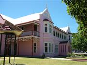
Substantial two-storey rendered brick building designed by Architect F.W. Steere in 1929 and built by Mr Ausden in the style of the nearby 1897 Convent. It had an asymmetrical front and a prominent gable with a central Gothic arched porch.
Catholic Education has a long history in Bunbury and began when Fr John Brady (Sydney) applied on 9.2.1844 to the Colonial Secretary for land in Bunbury to build a School, Church and Presbytery. Govenor Hutt approved the grant of Lots 202, 203, 204 and 205. Originally, the Sisters of Mercy who had arrived in Bunbury on 22.6.1883, lived in a small two roomed cottage and taught pupils there. Prior to that Fr Lecaille had established a Native School in 1857. By the close of 1884, a large purpose built elementary schoolroom was constructed of brick and became known as St Joseph's Hall (demolished 1982). In 1899, the upper and lower stories of the new Convent accommodated students of Sacred Heart School. A ten-room Music Hall opened on St Patrick's Day, 1918. 1929, heralded the erection of a double-storied St Josephs School adjacent to the Convent and run by the Sisters as a day and boarding school for girls. St Joseph's was designed by Architect F.W. Steere. The Convent of Mercy Group were sold to the City of Bunbury in 1981 and St Joseph's School and Hall were demolished in 1982 for redevelopment of the site as a car park.
DEMOLISHED
No visible remains.
| Reserve | Lot/Location | Plan/Diagram | Vol/Folio |
|---|---|---|---|
| 4 | D056982 4 | VOL1605FOL1 |
This information is provided voluntarily as a public service. The information provided is made available in good faith and is derived from sources believed to be reliable and accurate. However, the information is provided solely on the basis that readers will be responsible for making their own assessment of the matters discussed herein and are advised to verify all relevant representations, statements and information.
68 Wittenoom St Bunbury
used to be 64
Bunbury Regional Art Gallery Sacred Heart HS
Convent of Mercy & School St Patricks Conv
Bunbury
South West
Constructed from 1897 to 1924
| Type | Status | Date | Documents |
|---|---|---|---|
| Heritage List | Adopted | 15 Apr 2003 | |
| State Register | Registered | 20 Oct 2000 | HCWebsite.Listing+ListingDocument, HCWebsite.Listing+ListingDocument |
| Type | Status | Date | Documents |
|---|---|---|---|
| (no listings) |
| Type | Status | Date | Grading/Management | |
|---|---|---|---|---|
| Category | ||||
| Municipal Inventory | Adopted | 31 Jul 1996 | Exceptional Significance | |
| Register of the National Estate | Permanent | 18 Apr 1989 | ||
| Classified by the National Trust | Classified | 04 May 1981 | ||
| Register of the National Estate | Removed from RNE | 26 Oct 1999 | ||
Convent and Chapel - good. Since the purchase by the City of Bunbury in 1981, renovation and restoration has been completed with funds from the Western Australian Government and the City of Bunbury. St Josephs School and Hall demolished in 1982 for redevelopment of site as car park.
| Name | Type | Year From | Year To |
|---|---|---|---|
| Michael Cavanagh | Architect | - | - |
| Frederick Watler Steere | Architect | - | - |
| Library Id | Title | Medium | Year Of Publication |
|---|---|---|---|
| 7299 | Bunbury images : people and places. | Book | 2004 |
| 4880 | Bunbury Regional Art Galleries conservation plan. | Heritage Study {Cons'n Plan} | 2000 |
| 11822 | Convent of Mercy Group (fmr), 68 Wittenoom Street, Bunbury | Heritage Study {Cons'n Plan} | 2020 |
| 1600 | City of Bunbury Regional Art Galleries Conservation Plan | Heritage Study {Cons'n Plan} | 1996 |
Individual Building or Group
| Epoch | General | Specific |
|---|---|---|
| Present Use | RELIGIOUS | Monastery or Convent |
| Other Use | EDUCATIONAL | Combined School |
| Original Use | RELIGIOUS | Church, Cathedral or Chapel |
| Style |
|---|
| Federation Gothic |
| Type | General | Specific |
|---|---|---|
| Roof | METAL | Corrugated Iron |
| Wall | BRICK | Rendered Brick |
| General | Specific |
|---|---|
| SOCIAL & CIVIC ACTIVITIES | Religion |
This information is provided voluntarily as a public service. The information provided is made available in good faith and is derived from sources believed to be reliable and accurate. However, the information is provided solely on the basis that readers will be responsible for making their own assessment of the matters discussed herein and are advised to verify all relevant representations, statements and information.
Constructed from 1897, Constructed from 1923
Convent of Mercy Group (fmr), a two-storeyed rendered-brick and corrugated steel convent and chapel complex in the Federation Gothic style, has cultural heritage significance for the following reasons: the place represents the role of the Sisters of the Convent of Mercy in both pastoral care and education in the Australind-Bunbury region of the State from the arrival of Mother Placida and two other nuns in 1883 until the closure of the convent circa 1979; the convent and two-storeyed convent chapel are notable representative examples of the Federation Gothic style of architecture typical of religious and educational institutions of the period. The whole complex exhibits excellence of design in the harmony of forms and materials, in the restful and confident proportions, and in the spatial continuity, despite apparent staged development; the picturesque quality of the complex is an essential component of the townscape of central Bunbury. The complex forms a well-defined edge to the urban form of the City and is an imposing landmark in the context of the more domestic scaled surrounding streets; the convent building was designed by Michael Francis Cavanagh, eminent architect of the period who carried out numerous commissions for the Roman Catholic Church, including St Mary's Roman Catholic Cathedral, Perth. The place is also associated with architect of the school, Frederick Walter Steere and builder of the chapel, Joseph George Hough; the place is representative of the role played by the Roman Catholic nuns in the establishment of a community, a role that is no longer practised, but which has provided a substantial legacy to the Catholic community in the State; and, the place is highly valued by the community as a consequence of its role in the culture and the arts, both in its former religious and teaching role (especially with respect to music) and its more recent role as an arts centre. This is evidenced by the adaptation of the place to an arts complex in the 1980s.
The Convent [Sancto Patritio Hiberniae Apostolo] is a two storey rendered brick and iron building in the Victorian Gothic style, with a symmetrical front; designed by Michael Cavanagh and built in 1897. There is a Gothic arcade on the first floor between gables with bay windows on both floors. The 1923 Chapel is two storey, the lower floor being below street level. Its style and date are the same as the Convent. Face brickwork is exposed, with bands of render at the rear and west side and the front and east side are rendered. The complex was renovated in 1985 under architect, Ian Molyneux, and is now known as the Bunbury Regional Art Galleries. At the time, it incorporated a ballet studio; music room; lecture room and two art galleries. Interpretation of past use of the Convent is achieved by the recreation of a Nun's cell in a former upstairs bedroom and the return of other relevant pieces of furniture to their former home.
The Sisters of Mercy Group site has a long and complex history, dating back to the arrival of Catholics in Australia in the 1840s. In February 1844, Father John Brady (who was based in Sydney) applied to the Colonial Secretary for land in Bunbury on which to build a Catholic school, church and presbytery. Governor Hutt approved a grant of Lots 202, 203, 204, 205 in 1846. However, the first Catholic priest to be appointed to the South West district was sent to Dardanup, not Bunbury and it was not until 1857 that the first church was commenced. It is likely that when Father Adolphus Lecaille, a Belgian priest, arrived in 1858, the church was only half built and that he finished its construction. When Father Garrido visited in May 1858 he complained to Bishop Serra that the chapel in Bunbury was only half floored and had no windows. Lecaille went on to build a presbytery in 1860 and in 1862 had the church rebuilt in brick. In 1882, a gallery was added to the small church and in 1884, three Sisters of the Order of Mercy arrived in Bunbury to begin their work as teachers. A small school and convent were built, where the sisters taught and lived for the next 14 years. Circa 1896, St Joseph’s Hall was built by well known contractor, Mr Atkins, to provide additional teaching accommodation. St Joseph’s served the dual purpose of church and school. St Joseph’s Hall was also used for girls’ dormitories upstairs and classrooms on the ground floor. The convent, facing Prinsep Street, was pulled down in 1896/97 and replaced with new buildings designed by Michael Cavanagh. The new convent was opened on 12 December 1897 with the blessing of the Bishop of Perth, the Right Reverend M Gibney. A chapel was built in 1923/24 by local builder, Joseph George Hough. In 1929, St Joseph’s School was built next to the Convent. The school was designed by local architect, Frederick Walter Steere, and was operated by the Sisters of Mercy as a boarding and day school for girls. St Joseph’s Girls School and the Marist Brothers College amalgamated in the early 1970s and took in the first intake of students in 1973. In 1981, the Convent Complex was purchased by the Bunbury City Council at a cost of $1.2 million and the Sisters moved out the following year. The school building (1929) and St Joseph’s Hall (c 1897) was demolished in 1982 and the Convent (1897) was converted for used of the Bunbury Art Gallery and Community Arts Complex. The remaining buildings were converted during 1985/86 to provide two art galleries, lecture room, ballet studio, music room and a coffee shop. A nun’s cell was recreated in an upstairs bedroom of the convent to provide a link with the past and other pieces of furniture were returned to the building. The Galleries opened on 14 February 1987, when Bunbury Citizen of the Year, George Baxter, cut a ribbon fashioned in the shape of the building with a ceremonial sword. The former convent has been known variously as the Bunbury Art Galleries and Bunbury Regional Art Gallery. It is currently called the Bunbury Regional Art Galleries. It houses the City of Bunbury’s art collection, which grew from a bequest in 1948 to the Western Australian Government by Sir Claude Hotchin of 20 paintings for an art gallery in Bunbury. (Between 1948 and 1977, Hotchin donated an estimated 2,000 original paintings to shire councils, hospitals and galleries throughout the State in an effort to ‘stimulate art appreciation’. Many of the small regional collections have remained unchanged from the time of donation.) For further information, see ‘Regional Art Galleries Conservation Plan, prepared by Considine & Griffiths Architects for Bunbury Regional Art Galleries, March 2000.
High degree of integrity (original intent clear, current use compatible, high long term sustainability). Medium degree of authenticity - alterations but with much original fabric remaining (These statements based on street survey only). The remaining buildings remain true to form although major renovation and restoration work was completed with funding from the WA Govt and the City of Bunbury beginning 1985.
Condition assessed as good (assessed from streetscape survey only).
| Name | Type | Year From | Year To |
|---|---|---|---|
| Nunan, Joseph [Plans dated May 1883] | Architect | - | - |
| Reserve | Lot/Location | Plan/Diagram | Vol/Folio |
|---|---|---|---|
| 6 | D056982 6 | VOL1603FOL700 |
This information is provided voluntarily as a public service. The information provided is made available in good faith and is derived from sources believed to be reliable and accurate. However, the information is provided solely on the basis that readers will be responsible for making their own assessment of the matters discussed herein and are advised to verify all relevant representations, statements and information.
74 Wittenoom St Bunbury
Freemasons Hall; Wellington Lodge
Bunbury
South West
Constructed from 1893 to 1985
| Type | Status | Date | Documents |
|---|---|---|---|
| Heritage List | Adopted | 15 Apr 2003 | |
| State Register | Registered | 26 May 2006 | HCWebsite.Listing+ListingDocument, HCWebsite.Listing+ListingDocument |
| Type | Status | Date | Documents |
|---|---|---|---|
| (no listings) |
| Type | Status | Date | Grading/Management | |
|---|---|---|---|---|
| Category | ||||
| Art Deco Significant Bldg Survey | Completed | 30 Jun 1994 | ||
| Municipal Inventory | Adopted | 31 Jul 1996 | Exceptional Significance | |
Masonic Hall, Bunbury is in good condition, with continued use resulting in regular maintenance
| Name | Type | Year From | Year To |
|---|---|---|---|
| Herbert Eales & Eustace Cohen | Architect | 1935 | - |
| W. T. Leighton | Architect | 1935 | - |
| Library Id | Title | Medium | Year Of Publication |
|---|---|---|---|
| 7299 | Bunbury images : people and places. | Book | 2004 |
Individual Building or Group
| Epoch | General | Specific |
|---|---|---|
| Original Use | SOCIAL\RECREATIONAL | Masonic Hall |
| Present Use | SOCIAL\RECREATIONAL | Masonic Hall |
| Style |
|---|
| Inter-War Art Deco |
| Federation Academic Classical |
| Type | General | Specific |
|---|---|---|
| Roof | METAL | Corrugated Iron |
| Wall | BRICK | Common Brick |
| Wall | BRICK | Rendered Brick |
| Wall | STONE | Other Stone |
| General | Specific |
|---|---|
| DEMOGRAPHIC SETTLEMENT & MOBILITY | Settlements |
| SOCIAL & CIVIC ACTIVITIES | Institutions |
| SOCIAL & CIVIC ACTIVITIES | Cultural activities |
This information is provided voluntarily as a public service. The information provided is made available in good faith and is derived from sources believed to be reliable and accurate. However, the information is provided solely on the basis that readers will be responsible for making their own assessment of the matters discussed herein and are advised to verify all relevant representations, statements and information.
Constructed from 1893 to 1935
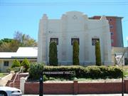
Freemasons Hall, 74 Wittenoom Street is a single storey double volume rendered brick and corrugated iron building constructed in 1893 in the Federation Academic style of architecture and remodelled in 1935 in the Inter-War Art Deco style, has cultural heritage significance for the following reasons: the place is a fine intact example of a building remodeled in the Iner-War Art Deco style and is a landmark with it's elevated and visually dominant position on Wittenoom Street and its distinctive Art Deco façade; the place contributes to the civic precinct within the Bunbury CBD as one of a group of places that includes the City Council and Gardens, Courts and Police Station; the place is the second oldest extant purpose-built Masonic building in Western Australia, continues to function as a masonic Hall and is associated in particular with the establishment in 1886 of the Wellington Lodge, the first masonic Lodge in the South West; and the 1935 Art Deco remodeling of the place was designed by prominent Western Australian architects Herbert Eales and Eustace Cohen. The 1985 additions are of low significance.
Freemasons Hall, 74 Wittenoom Street is a single storey double volume rendered brick and corrugated iron building constructed in 1893 in the Federation Academic style of architecture and remodelled in 1935 in the Inter-War Art Deco style. The building has a dominant and distinctive Inter-War Art Deco facade to Wittenoom Street. The site is retained by a low brick wall and contains the Masonic Hall along its north and eastern boundaries and a smaller wing of rooms along the western boundary. The facade features the distinctive symbol of Freemasonary placed high in the centre of a solid wall divided into three panels with a small window in each. Renovations and additions to the Hall were undertaken in 1935 and again in 1985.
Freemason’s Hall was built in 1893 for the Wellington Lodge. The first Freemason’s Lodge in Western Australia was established in Perth, after Governor John Hutt and Colonial Secretary Peter Brown sought a charter from the Grand Lodge of England. The Lodge of St John, No 712, EC (English Constitution) was consecrated on 4 April 1843. A second lodge (the Lodge of Unity) was formed in 1845 but it soon amalgamated with the Lodge of St John. It was not until 1865 that another independent lodge was formed – Fremantle Lodge (No 1033 EC). By 1888, another five lodges had formed: Plantagenet Lodge (Albany) in 1873, Geraldton in 1877, and Wellington (Bunbury), York and St George’s in 1886. Wellington Lodge was formed on 10 May 1886 by ten local men under the patronage of the United Grand Lodge of England. Wellington Lodge was number 1840 on the Grand Lodge’s register. The consecration ceremony was performed by Brothers F L Hussey, the Worshipful Master of St John’s Lodge, R Perthbert and C Y Dean, also of Perth Lodge. Charles Wisbey (publican at the Prince of Wales Hotel and Bunbury’s first mayor), Thomas Hayward (local businessman) and William Spencer (local businessman and politician) were amongst the first members. In 1891, Wellington Lodge purchased land in Wittenoom Street with a view to building a hall. However, work was delayed until the membership was built up – both to justify building a hall and to finance its construction. Plans were eventually drawn up and on 30 January 1893, Charles Wisbey laid the foundation stone. During the formal Mason ceremony, a bottle containing two newspapers, coins and a program of the event were placed in the cavity of the foundation stone. Contractors John and Harold Gibbs finished construction at a cost of £670 in July 1893. However, the building was not consecrated for Masonic purposes until 23 March 1906. In the intervening period, the hall was used as a Lodge and as a public hall. The consecration of the hall as a Temple in 1906 necessitated some internal alterations to allow its sole use. From this time, the Lodge closed its doors to outside visitors. The building originally had a Federation style façade divided into three bays with a parapet and central pediment displaying the Masonic symbol. There was an arched window in the central bay of the main façade and high windows, characteristic of Masonic buildings, on the eastern and southern elevations. When Wellington Lodge became a founding member of the Grand Lodge of Western Australia in 1900, it was designated Lodge No 4. Wellington Lodge supported the formation of a second Lodge in Bunbury in the early twentieth century under the Scottish Constitution. The new lodge was consecrated as Bunbury Lodge, No 883 SC (Lodge No 70 of the Grand Lodge of Western Australia). The Bunbury Lodge used the Wellington Lodge’s hall for their ceremonies and other events. It is likely that the growing membership of both lodges resulted in the need to increase accommodation in the 1893 hall. Wellington Lodge commissioned prominent architects Herbert Eales and Eustace Cohen to design additions to their hall. The work comprised a new formal hall, ancillary rooms (including enlargement of the southern wing) and the modernisation of the exterior to incorporate a new Art Deco façade and entrance portico where the southern wing and hall joined. Eales was a Freemason in Perth and Cohen was a member of Wellington Lodge. The interior work was completed by a Mr Hunt, who was a member of the Victoria Park Lodge. The new hall was opened on 20 September 1935 by the Most Worshipful Grand Master of the Lodge, Brother F A McCullen in front of about 200 members of both the Wellington Lodge and the Bunbury Lodge. Bro McCullen also unveiled a memorial tablet on the front of the building to commemorate the occasion. The two lodges became joint owners of the building at this time, forming ‘The Wellington and Bunbury Masonic Hall Company Limited’ for the purpose. The new ownership was registered on 1 April 1936. Prominent members of the two lodges included: •Bro T W Paisley: second Worshipful Master of Welligton Lodge and prominent member (honoris causa) of the Grand Lodge of WA •Bro E Woodrow: later Junior Grand Master to the District Lodge •Bro W H Timperely: Bunbury Resident Magistrate •Bro Sir Newton J Moore: later Pro Grand Master of Grand Lodge of WA and State Premier (1906-1910), Agent General to London and member of the House of Commons. Very few physical changes have been made to the building since the 1938 refurbishment. In 1985, a new kitchen and toilet wing were added to the rear of the building. a short history of the Lodge was written as part of the centenary celebrations of Wellington Lodge in 1986. This history is largely based on the Documentary Evidence in Heritage Council of Western Australia, ‘Register Documentation: Masonic Hall, Bunbury’, prepared by Kris Bizzaca, 2005.
High degree of integrity (original intent clear, current use compatible, high long term sustainability). High degree of authenticity with much original fabric remaining. (These statements based on street survey only). Essentially the same form as the original with addition of kitchen and toilet wing during 1985 to the rear on the southern side; which does not detract from the essentially symmetrical look of the Hall.
Condition assessed as good (assessed from streetscape survey only).
| Reserve | Lot/Location | Plan/Diagram | Vol/Folio |
|---|---|---|---|
| 100 | P054407 100 | VOL666FOL148 |
This information is provided voluntarily as a public service. The information provided is made available in good faith and is derived from sources believed to be reliable and accurate. However, the information is provided solely on the basis that readers will be responsible for making their own assessment of the matters discussed herein and are advised to verify all relevant representations, statements and information.
76 Wittenoom St Bunbury
Bunbury
South West
Constructed from 2002
| Type | Status | Date | Documents |
|---|---|---|---|
| (no listings) |
| Type | Status | Date | Documents |
|---|---|---|---|
| RHP - To be assessed | Current | 28 Sep 2012 |
| Type | Status | Date | Grading/Management | |
|---|---|---|---|---|
| Category | ||||
| (no listings) | ||||
Earlier station (c.1968) demolished but some components may still be extant at other locations in Bunbury.
Individual Building or Group
| Epoch | General | Specific |
|---|---|---|
| Other Use | GOVERNMENTAL | Police Station or Quarters |
| General | Specific |
|---|---|
| SOCIAL & CIVIC ACTIVITIES | Law & order |
This information is provided voluntarily as a public service. The information provided is made available in good faith and is derived from sources believed to be reliable and accurate. However, the information is provided solely on the basis that readers will be responsible for making their own assessment of the matters discussed herein and are advised to verify all relevant representations, statements and information.
Wittenoom St to Jetty Bunbury
Bunbury
South West
Constructed from 1887 to 1891
| Type | Status | Date | Documents |
|---|---|---|---|
| (no listings) |
| Type | Status | Date | Documents |
|---|---|---|---|
| RHP - Does not warrant assessment | Current | 25 Oct 2019 |
| Type | Status | Date | Grading/Management | |
|---|---|---|---|---|
| Category | ||||
| Municipal Inventory | Adopted | 31 Jul 1996 | Historic Site | |
| Municipal Inventory | Adopted | 04 Sep 2001 | ||
Historic Site
| Epoch | General | Specific |
|---|---|---|
| Present Use | VACANT\UNUSED | Vacant\Unused |
| Original Use | Transport\Communications | Rail: Other |
| Style |
|---|
| Other Style |
| Type | General | Specific |
|---|---|---|
| Other | METAL | Cast Iron |
| Other | TIMBER | Log |
This information is provided voluntarily as a public service. The information provided is made available in good faith and is derived from sources believed to be reliable and accurate. However, the information is provided solely on the basis that readers will be responsible for making their own assessment of the matters discussed herein and are advised to verify all relevant representations, statements and information.
Constructed from 1887 to 1891
DEMOLISHED The horse drawn railway from the timber producing hinterland to the fledgling port of Bunbury was the first major transport link in Bunbury. The railway served local, intercolonial and international trade.
DECONSTRUCTED
A railway line was built from the Blackwood to Bunbury in 1887 to serve the fledgling timber industry. In the centre of Bunbury, the railway ran from the jetty down Wittenoom Street, then curved eastward by the old Post Office and Court House. The railway was built of iron gauge line on timber sleepers and there was a goods shed where Centennial Gardens are now located (also the site of the Military Barracks). Local contractor G J Hastie used horses to pull the rolling stock which transported the timber from the nearby ranges to the port. The first railway was replaced by the Bunbury to Boyanup Railway, which was officially opened on 12 March 1891 with Loco No 17 as the first wood-fired locomotive on the route.
DECONSTRUCTED
No visible remains.
This information is provided voluntarily as a public service. The information provided is made available in good faith and is derived from sources believed to be reliable and accurate. However, the information is provided solely on the basis that readers will be responsible for making their own assessment of the matters discussed herein and are advised to verify all relevant representations, statements and information.
Wittenoom, Molloy & Symmons Sts Bunbury
As laid out on 1841 Town Survey
Lord Forrest Car Park
Ron Mort Park
Bunbury
South West
Constructed from 1841
| Type | Status | Date | Documents |
|---|---|---|---|
| (no listings) |
| Type | Status | Date | Documents |
|---|---|---|---|
| (no listings) |
| Type | Status | Date | Grading/Management | |
|---|---|---|---|---|
| Category | ||||
| Municipal Inventory | Adopted | 04 Sep 2001 | ||
| Municipal Inventory | Adopted | 31 Jul 1996 | Historic Site | |
| Name | Type | Year From | Year To |
|---|---|---|---|
| Henry Mortlock Ommanney | Architect | - | - |
Historic Site
| Epoch | General | Specific |
|---|---|---|
| Present Use | COMMERCIAL | Other |
| Present Use | PARK\RESERVE | Park\Reserve |
| Original Use | RELIGIOUS | Other |
This information is provided voluntarily as a public service. The information provided is made available in good faith and is derived from sources believed to be reliable and accurate. However, the information is provided solely on the basis that readers will be responsible for making their own assessment of the matters discussed herein and are advised to verify all relevant representations, statements and information.
Constructed from 1841
HISTORIC SITE An important component in Assistant Surveyor Ommanney's plan in 1841 where he drew a cross on the Map to indicate where the Anglican Church would sit as the centre of village life in Bunbury. The Anglican Church did not take up the land and the square was not developed.
Public Open Space now incorporates Ron Mort Park and part of the Lord Forrest parking area.
Leschenault Square was originally surveyed as Town Lot 295 in 1841 by Henry Mortlock Ommaney and marked as the Anglican Church site. Identified on the plan with a cross, the lot was to become the central focus of village life. However Lot 295 was surrendered to the Crown and the Anglican Church eventually built St Paul’s Pro Cathedral on another site. In 1843, Wollaston wrote on his rough map of the Bunbury townsite: "it would be imprudent to enter upon anything substantial by way of a church here until its progress is more decided - I very much doubt it ever becoming anything much of a town." Although Leschenault Square was not developed for the purpose intended by Ommaney in 1841, it remained public open space for many years. From 1845, the Wellington-Nelson-Murray Agricultural Society used the ‘square’ as their showgrounds. Leschanault Square is no longer recognizable in the layout of Bunbury. It is incorporated into Ron Mort children’s park and part of the Lord Forrest Hotel car park.
Although the site can be identified, the original survey plot no longer exists.
Good.
| Reserve | Lot/Location | Plan/Diagram | Vol/Folio |
|---|---|---|---|
| 754 | R 21902 | VOLLR3102FOL494 |
This information is provided voluntarily as a public service. The information provided is made available in good faith and is derived from sources believed to be reliable and accurate. However, the information is provided solely on the basis that readers will be responsible for making their own assessment of the matters discussed herein and are advised to verify all relevant representations, statements and information.
23 Wollaston St Bunbury
Cnr Ommanney St
Anglican Mission to Seamen, Flying Angel Club
Seafarer's Rest
Bunbury
South West
Constructed from 1905
| Type | Status | Date | Documents |
|---|---|---|---|
| (no listings) |
| Type | Status | Date | Documents |
|---|---|---|---|
| (no listings) |
| Type | Status | Date | Grading/Management | |
|---|---|---|---|---|
| Category | ||||
| Municipal Inventory | Adopted | 04 Sep 2001 | ||
| Municipal Inventory | Adopted | 31 Jul 1996 | Historic Site | |
Historic Site
| Epoch | General | Specific |
|---|---|---|
| Present Use | VACANT\UNUSED | Vacant\Unused |
| Original Use | SOCIAL\RECREATIONAL | Other |
| Type | General | Specific |
|---|---|---|
| Wall | BRICK | Common Brick |
This information is provided voluntarily as a public service. The information provided is made available in good faith and is derived from sources believed to be reliable and accurate. However, the information is provided solely on the basis that readers will be responsible for making their own assessment of the matters discussed herein and are advised to verify all relevant representations, statements and information.
Constructed from 1905
DEMOLISHED Bunbury's Sailors' Rest was founded by Eliza Cons, sister in law of Robert Forrest, and a staunch supported of the ideals of the Women’s Christian Temperance Union. The Sailors Rest was part of an international organisation to provide sailors a 'home away from home' while visiting ports around the world. They provided a quite place for rest and recreation where volunteers addressed a range of needs. The Bunbury Sailors' Rest was the first in Western Australia. The service continues in Bunbury on another site.
DEMOLISHED
The first Sailors’ Rest was established in England in the 1870s by Agnes Weston to provide refreshment and accommodation if needed. Although intended as a house for the promotion of the temperance movement, the Sailors’ Rest was not confined to those of a similar view and all sailors were welcome to use the facilities. Lectures were arranged, as well as religious services and there was the chance to sign the ‘pledge’ to refrain from drinking alcohol. The idea soon spread throughout the ports of England and to the English colonies. In 1899, Eliza Cons set up the Bunbury branch of the organization – the first in Western Australia – with the support of the Church of England and the local Council. She opened a Sailor’ Rest on 22 October 1900 in, ironically, rented rooms at Pier’s/Gordon’s Hotel. Eliza Cons had come out to Western Australia in 1888, from England after her sister, Esther Forrest (nee Cons; wife of Robert) was semi-invalided in a riding accident. Eliza arrived in 1888. The Sailor’s Rest was administered by a group of women under the stewardship of Eliza Cons, who fully supported the ideals of the Women’s Christian Temperance Union. The organization secured land in Wollaston Street near Guppy Park for £750 and on 27 January 1905, the foundation stone of their own building was laid. Sailor’s Rest was a modest brick building with a corner entry, situated not far from the Pier Hotel. The building featured alternate brick and white stucco bands (bandage effect). The framed arched windows and doors were also highlighted in stucco. The name of the establishment was written in raised lettering over the entrance door. The Bunbury Diocesan Trustees took over running the Sailors’ Rest in 1920. In 1966, Sailor’s Rest relocated to Victoria Street and the 1905 building was demolished to make way for the Western Australian Government Railway’s administration building and district engineer’s office.
DEMOLISHED
DEMOLISHED
| Reserve | Lot/Location | Plan/Diagram | Vol/Folio |
|---|---|---|---|
| 222 | D093342 222 |
This information is provided voluntarily as a public service. The information provided is made available in good faith and is derived from sources believed to be reliable and accurate. However, the information is provided solely on the basis that readers will be responsible for making their own assessment of the matters discussed herein and are advised to verify all relevant representations, statements and information.
Wollaston St - now Guppy Park Bunbury
Guppy Park formerly Gretna Green
Bunbury
South West
Constructed from 1857 to 1862
| Type | Status | Date | Documents |
|---|---|---|---|
| (no listings) |
| Type | Status | Date | Documents |
|---|---|---|---|
| (no listings) |
| Type | Status | Date | Grading/Management | |
|---|---|---|---|---|
| Category | ||||
| Municipal Inventory | Adopted | 31 Jul 1996 | Historic Site | |
Historic Site
| Epoch | General | Specific |
|---|---|---|
| Present Use | PARK\RESERVE | Park\Reserve |
| Original Use | COMMERCIAL | Shop\Retail Store {single} |
| Other Use | RESIDENTIAL | Conjoined residence |
| Type | General | Specific |
|---|---|---|
| Wall | BRICK | Common Brick |
| Roof | METAL | Corrugated Iron |
| General | Specific |
|---|---|
| OCCUPATIONS | Commercial & service industries |
This information is provided voluntarily as a public service. The information provided is made available in good faith and is derived from sources believed to be reliable and accurate. However, the information is provided solely on the basis that readers will be responsible for making their own assessment of the matters discussed herein and are advised to verify all relevant representations, statements and information.
Constructed from 1857, Constructed from 1862
DEMOLISHED Thomas Hayward & Sons Original Store was one of the earliest businesses established in Bunbury. It was also one of the longest running importing and trading concerns in the town. Hayward's first store is commemorated with a stone plaque at Guppy Park.
DEMOLISHED.
At the age of 21 and financed by his father, Thomas Hayward sailed to Western Australia in 1854. He first established a prosperous farm at Wokalup before establishing Thomas Hayward and Sons, one of Bunbury’s first businesses. Thomas Hayward founded his merchant and import business in 1862 when he purchased Edward G Hester’s store, which had been established in the harbour area in the 1840s. Hayward built a small warehouse to sell imported ironmongery and farm implements ‘on each and every Saturday’. The business grew and was firmly established in daily trading by 1862. By 1874, Hayward had built a house next to his store. The house and store were located on the original alignment of Wollaston Street (now Guppy Park). The property stretched across three allotments and contained many buildings common to a warehouse, store and dwelling on the one site. The main brick and iron building had one and two storey levels and newspaper reports suggest that it was replaced in 1897 by a new warehouse to a design by architect T B Jackson. Thomas Haywood, one of the earliest farmers in the South West, was a storekeeper, importer and member of the Bunbury Town Trust, as well as member of the Legislative Assembly for Bunbury (1901) and Wellington (1904-11). Thomas Hayward and Son did most of the ironmongery in the district, carried farm tools and equipment, bought local produce and shipped and made advances on wool. George Hayward (Thomas’ son) and A R Foreman (Thomas’ son-in-law) took over the business in 1898 and in 1910 F W Roberts purchased a partnership in the business. In 1912, Thomas Hayward and Son became a limited liability company. In 1919, the firm established new premises for a department store on the corner of Stephen and Arthur Streets (this site). Thomas had died by this time. The large department store had high trussed ceilings and carried a wide range of stock on shelves running the length of the pavilion. Later, this store was taken over by Boans and was demolished in 1969 for a new store.
DEMOLISHED. Commemorative plaque for Hayward's 1st Store in Guppy Park.
No visible remains.
| Reserve | Lot/Location | Plan/Diagram | Vol/Folio |
|---|---|---|---|
| GUPPYPARK | 808 | R 7891 | VOLLR3127FOL34 |
This information is provided voluntarily as a public service. The information provided is made available in good faith and is derived from sources believed to be reliable and accurate. However, the information is provided solely on the basis that readers will be responsible for making their own assessment of the matters discussed herein and are advised to verify all relevant representations, statements and information.
Wollaston St NW Cnr Casuarina Dv Bunbury
Old Bus Shed
Bunbury
South West
Constructed from 1947
| Type | Status | Date | Documents |
|---|---|---|---|
| Heritage List | Adopted | 15 Apr 2003 |
| Type | Status | Date | Documents |
|---|---|---|---|
| (no listings) |
| Type | Status | Date | Grading/Management | |
|---|---|---|---|---|
| Category | ||||
| Municipal Inventory | Adopted | 04 Sep 2001 | ||
| Municipal Inventory | Adopted | 31 Jul 1996 | Historic Site | |
Individual Building or Group
| Epoch | General | Specific |
|---|---|---|
| Original Use | Transport\Communications | Rail: Other |
| Present Use | COMMERCIAL | Shopping Complex |
| Style |
|---|
| Other Style |
| Type | General | Specific |
|---|---|---|
| Wall | BRICK | Common Brick |
| Roof | ASBESTOS | Fibrous Cement, corrugated |
This information is provided voluntarily as a public service. The information provided is made available in good faith and is derived from sources believed to be reliable and accurate. However, the information is provided solely on the basis that readers will be responsible for making their own assessment of the matters discussed herein and are advised to verify all relevant representations, statements and information.
Constructed from 1947
DEMOLISHED The Railway Road Workshops represent an era when trains were widely used as an economic and popular mode of moving goods and people. The workshops were built to service the trains. In the post World-War II period, bus services were introduced to replace passenger trains and the workshops were then used to service the buses.
DEMOLISHED
Government Railway Road Workshops were built c 1947. Here, Government Railway employees maintained and serviced buses and railway road vehicles that operated throughout the South West. The Workshops were built close to the railway marshalling yards complex, which occupied a large area of land on the eastern fringe of the central business district. By the 1950s, Bunbury’s population was growing and the railway system was proving inadequate. By 1948, the Government run bus service was proving much more successful than the dated railway system. The railway road vehicles transported ilmenite from the mineral sands mines to storage areas at the Port of Bunbury for a time. In 2001, the place was being used for commercial purposes. By this time, it had been partially demolished to make way for street realignment in the area (the original street pattern was at 45 degrees to the present north south pattern). By 2006, the workshops had been demolished.
DEMOLISHED
| Reserve | Lot/Location | Plan/Diagram | Vol/Folio |
|---|---|---|---|
| 222 | D093342 222 |
This information is provided voluntarily as a public service. The information provided is made available in good faith and is derived from sources believed to be reliable and accurate. However, the information is provided solely on the basis that readers will be responsible for making their own assessment of the matters discussed herein and are advised to verify all relevant representations, statements and information.
Stirling, Charles, Park, Moore, Ednie, Thomas, Braund, Hayes and Albert Bunbury and East Bunbury
Stirling, Charles, Park, Moore, Ednie, Thomas, Braund, Hayes and Albert
Stirling Street Heritage Precinct (fmr)
Bunbury
South West
| Type | Status | Date | Documents |
|---|---|---|---|
| Heritage Area | Adopted | 21 Aug 2018 | |
| Heritage Area | Adopted | 18 Feb 2003 | |
| Heritage Area | Adopted | 26 Feb 2008 |
| Type | Status | Date | Documents |
|---|---|---|---|
| (no listings) |
| Type | Status | Date | Grading/Management | |
|---|---|---|---|---|
| Category | ||||
| Municipal Inventory | Adopted | 31 Jul 1996 | Recommend RHP | |
Precinct or Streetscape
| Epoch | General | Specific |
|---|---|---|
| Original Use | RESIDENTIAL | Conjoined residence |
| Original Use | RESIDENTIAL | Terrace housing |
| Present Use | RESIDENTIAL | Other |
| Original Use | RESIDENTIAL | Single storey residence |
| Style |
|---|
| Vernacular |
| Federation Queen Anne |
| Type | General | Specific |
|---|---|---|
| Roof | METAL | Corrugated Iron |
| Wall | TIMBER | Weatherboard |
| Wall | BRICK | Common Brick |
| General | Specific |
|---|---|
| OUTSIDE INFLUENCES | Water, power, major t'port routes |
| SOCIAL & CIVIC ACTIVITIES | Environmental awareness |
| DEMOGRAPHIC SETTLEMENT & MOBILITY | Land allocation & subdivision |
| OCCUPATIONS | Fishing & other maritime industry |
| OCCUPATIONS | Commercial & service industries |
| PEOPLE | Early settlers |
| PEOPLE | Famous & infamous people |
| DEMOGRAPHIC SETTLEMENT & MOBILITY | Settlements |
| OCCUPATIONS | Domestic activities |
| SOCIAL & CIVIC ACTIVITIES | Cultural activities |
| OCCUPATIONS | Rural industry & market gardening |
| PEOPLE | Local heroes & battlers |
This information is provided voluntarily as a public service. The information provided is made available in good faith and is derived from sources believed to be reliable and accurate. However, the information is provided solely on the basis that readers will be responsible for making their own assessment of the matters discussed herein and are advised to verify all relevant representations, statements and information.

Constructed from 1875 to 1925
STATE (a). Precinct which contains areas of high cultural significance illustrating the evolution of settlement with the period 1875 to 1925 particularly well represented. The precinct contains areas of aesthetic characteristics highly valued by the community; cultural landscapes and notable streetscapes, all ensconced in a collection of harmoniously related buildings. Illustrations of several major historic themes of human settlement are evident. The precinct is also important for a range of social, cultural, education and spiritual associations. LOCAL (a) historically the area represents the development of a part of Captain James Stirling’s Leschenault Location 26, resulting from the expansion of residential development to the east of the Bunbury town centre following the relocation of the railway in 1893; (b) the area comprises a high concentration of single houses from the late nineteenth to mid twentieth century that includes a mix of upper, middle and working-class homes together with some individually significant places, including the State Government Infants School (1917), the Residency (1896) and the Red Mill Store and Residence (1897); (c) the area comprises highly intact streetscapes of heritage buildings of similar form and scale that are broadly unified as examples ranging from Federation Queen Anne, to modest timber framed and clad dwellings in the vernacular style typical of railway or wharf workers’ cottages from the early to mid-twentieth century; and (d) the aesthetic character of the area results from the irregular pattern of streets influenced by the alignment of the Blair Street former railway reserve to the west and the Leschenault Inlet to the north. This has led in some locations (e.g. Ednie Street, the northern section of Charles Street and part of Moore Street) to an unusual ‘saw tooth’ arrangement of timber cottages; which is rare, if not unique, in a West Australian residential context.
Stirling Street precinct contains a broad cross-section of dwellings and other buildings from early in the history of settlement, which has the potential to yield information that will contribute to a better understanding of the natural and cultural history of Western Australia. The study also identifies that currently the place contains several vacant sites, other sites of non-conforming use and multiple-dwelling developments which may erode the intention of preserving the heritage character of the area.
The precinct dates from the earliest land grants to Governor Sir James Stirling in 1830 to the later Pensioner Lots of 1 acre which were allocated by Captain Bruce to those Pensioner Guards who volunteered to relieve the post garrisoned by the Bunbury detachment of the 99th Regiment at Australind in 1851. He first housed them in the Barracks until they had built cottages on their own White Rd [now Stirling Street] allotments. The scheme proved sound judgement on the part of Cptn Bruce as, in the middle of 1852 , he could report to the Governor that with a cottage and an acre of land each, the eight Pensioners comprising the outpost were well satisfied thus the scheme was an unqualified success. The Government approved an amount of £15 towards the cost of erecting each Pensioner house. Over time, some land was reclaimed and some became subdivided into more and more housing blocks. Today, the built heritage between the years 1875 to pre WWII is well represented. Many residences are vernacular forms built for families whose main occupation was associated with maritime, lumper or railway activities. Also a number of successful businessmen established their homes in the Stirling Street precinct because of its close proximity to the town and the harbour area.
The fabric which remains from the days of early settlement to pre WWII is of particular note.
Good
| Name | Type | Year From | Year To |
|---|---|---|---|
| Molyneux, Ian | Architect | - | - |
| Ref ID No | Ref Name | Ref Source | Ref Date |
|---|---|---|---|
| Land for sale by James White | Southern Times | 27.3.1888 | |
| Historical Photograph Section: #73 Stirling Street | South Western Times | 1935 | |
| The Veterans:A History of the Enrolled Pensioner Force in WA 1850-1880 | Broomhall, F.H | 1975 | |
| BLSC - Card Index | Bunbury Local Studies Collection | ||
| Stirling Street Heritage Precinct Study - Draft Conservation and Guidelines | Molyneux, Ian | 1998 | |
| The Lower Preston River Settlement: Chronology of European Exploration and Settlement of the Lower Preston River at Bunbury | Molyneux, Ian | 1996 | |
| Residential blocks for sale at Norwood Park | Bunbury Herald | 4.6.1897 |
This information is provided voluntarily as a public service. The information provided is made available in good faith and is derived from sources believed to be reliable and accurate. However, the information is provided solely on the basis that readers will be responsible for making their own assessment of the matters discussed herein and are advised to verify all relevant representations, statements and information.
12 Preston St Bunbury, Rathmines
Bunbury
South West
Constructed from 1883
| Type | Status | Date | Documents |
|---|---|---|---|
| Heritage List | Adopted | 15 Apr 2003 |
| Type | Status | Date | Documents |
|---|---|---|---|
| RHP - Does not warrant assessment | Current | 26 Feb 2016 |
| Type | Status | Date | Grading/Management | |
|---|---|---|---|---|
| Category | ||||
| Municipal Inventory | Adopted | 31 Jul 1996 | Moderate Significance | |
Individual Building or Group
| Epoch | General | Specific |
|---|---|---|
| Present Use | RESIDENTIAL | Single storey residence |
| Original Use | FARMING\PASTORAL | Cottage |
| Original Use | FARMING\PASTORAL | Shed or Barn |
| Style |
|---|
| Victorian Colonial |
| Type | General | Specific |
|---|---|---|
| Wall | TIMBER | Weatherboard |
| Wall | TIMBER | Slab |
| Roof | METAL | Corrugated Iron |
| General | Specific |
|---|---|
| OCCUPATIONS | Grazing, pastoralism & dairying |
This information is provided voluntarily as a public service. The information provided is made available in good faith and is derived from sources believed to be reliable and accurate. However, the information is provided solely on the basis that readers will be responsible for making their own assessment of the matters discussed herein and are advised to verify all relevant representations, statements and information.

Constructed from 1883
House, 12 Preston Street, a single storey timber and iron house has cultural heritage significance for the following reasons: the place is a good early example of the Victorian Georgian style of architecture; the place has landmark qualities and contributes significantly to the streetscape and the community's sense of place; and, the windmill is a rare surviving example of an early form of domestic water supply in Bunbury.
House, 12 Preston Street is a single storey timber and iron house constructed in the Victorian Georgian style of Architecture. The walls are timber framed and clad with timber weatherboards. The roof is hipped and clad with corrugated iron. The verandah is under a continuous corrugated iron roof supported by timber posts. The symmetrical front façade has a central front door with timber framed windows. The house is situated at street level. There is a timber fence to the front boundary line. Proliferate foliage makes further description difficult. There is a windmill evident.
House, 12 Preston Street, was one of the original farmhouses in the Rathmines area and is the former home of E. H. Withers. It is located next to St Patrick’s Anglican Church (fmr). The windmill is now one of a few original remaining within the City of Bunbury and is located to the side of the house, most likely in its original position. E H (Ted) Withers was a well known diarist who regularly contributed to the local newspaper under the byline ‘E H W’ or ‘Old Bunbury’. Ted maintained that he was a personal friend of the bushranger Moondyne Joe (Joseph Bolitho Johns) and had met with him on several occasions. Ted died in 1942. Ted Withers had arrived in Western Australia with his brother, Frederick, his parents and cousin on the Dalhousie in January 1864. His father was the Reverend Joseph Withers, who served as chaplain on Dalhousie, which was a convict transport. In February 1896, the family moved to Bunbury where Reverend Withers was the chaplain from 1864 to 1880 and again from 1889 to 1893. The intervening years were spent at Williams. Between 1872 and 1883, Reverend Withers purchased Portion 11 of Location 16. Withers subdivided the land in 1895. The area was called Rathmines after the Withers’ home town in Ireland. House, 12 Preston Street had been built for Ted Withers by this time and was originally a farm house. In the late nineteenth and early twentieth centuries, it was common for householders to have a windmill in their yard. The windmill converted the energy of wind to rotational motion by means of vanes (called sails). Domestic windmills provided energy to wind pumps to lift water from an underground reservoir. No entries for this place could be found in the available rate books at the Bunbury Local Studies Collection.
Medium-High degree of integrity (original intent clear, current use compatible, high long term sustainability). High degree of authenticity with much original fabric remaining. (These statements based on street survey only).
Condition assessed as poor (assessed from streetscape survey only).
| Reserve | Lot/Location | Plan/Diagram | Vol/Folio |
|---|---|---|---|
| 47 | P000881 47 |
This information is provided voluntarily as a public service. The information provided is made available in good faith and is derived from sources believed to be reliable and accurate. However, the information is provided solely on the basis that readers will be responsible for making their own assessment of the matters discussed herein and are advised to verify all relevant representations, statements and information.
Bunury
Bunbury
South West
| Type | Status | Date | Documents |
|---|---|---|---|
| (no listings) |
| Type | Status | Date | Documents |
|---|---|---|---|
| (no listings) |
| Type | Status | Date | Grading/Management | |
|---|---|---|---|---|
| Category | ||||
| (no listings) | ||||
Other Aboriginal Site
| Epoch | General | Specific |
|---|---|---|
| Original Use | OTHER | Other |
| Present Use | OTHER | Other |
This information is provided voluntarily as a public service. The information provided is made available in good faith and is derived from sources believed to be reliable and accurate. However, the information is provided solely on the basis that readers will be responsible for making their own assessment of the matters discussed herein and are advised to verify all relevant representations, statements and information.
Frankel St Cnr Lowe St Carey Park
Bunbury
South West
| Type | Status | Date | Documents |
|---|---|---|---|
| (no listings) |
| Type | Status | Date | Documents |
|---|---|---|---|
| (no listings) |
| Type | Status | Date | Grading/Management | |
|---|---|---|---|---|
| Category | ||||
| Municipal Inventory | Adopted | 31 Jul 1996 | (Tree Register) | |
Good.
Tree
| Epoch | General | Specific |
|---|---|---|
| Original Use | OTHER | Other |
| Present Use | OTHER | Other |
| General | Specific |
|---|---|
| DEMOGRAPHIC SETTLEMENT & MOBILITY | Environmental change |
| SOCIAL & CIVIC ACTIVITIES | Environmental awareness |
| PEOPLE | Local heroes & battlers |
This information is provided voluntarily as a public service. The information provided is made available in good faith and is derived from sources believed to be reliable and accurate. However, the information is provided solely on the basis that readers will be responsible for making their own assessment of the matters discussed herein and are advised to verify all relevant representations, statements and information.
Christmas Tree (Nuytsia floribunda), at the corner of Frankel and Lowe Streets, Carey Park, has cultural heritage significance because: it is an uncommon example of remnant indigenous vegetation in urban Bunbury.
Mature "Christmas Tree" native to the South West which flowers prolifically over the summer period and is in full blossom in December.
The Christmas Tree (Nuytsia floribunda) at the corner of Frankel Street and Lowe Street, Carey Park, is a remnant of pre-settlement vegetation. There are no other examples in the immediate vicinity. This particular tree was mentioned in Bunbury City Council Minutes (1955) regarding its impending removal from the Frankel Street area. It was decided not to remove it. The tree produces a striking golden floral display during summer.
High degree of integrity.
Good.
This information is provided voluntarily as a public service. The information provided is made available in good faith and is derived from sources believed to be reliable and accurate. However, the information is provided solely on the basis that readers will be responsible for making their own assessment of the matters discussed herein and are advised to verify all relevant representations, statements and information.
Frankel St Cnr Woodrow & Ecclestone Sts Carey Park
Bunbury
South West
Constructed from 1955
| Type | Status | Date | Documents |
|---|---|---|---|
| (no listings) |
| Type | Status | Date | Documents |
|---|---|---|---|
| RHP - Assessed - Below Threshold | Current | 24 Sep 1999 |
| Type | Status | Date | Grading/Management | |
|---|---|---|---|---|
| Category | ||||
| Municipal Inventory | Adopted | 31 Jul 1996 | Historic Site | |
| Library Id | Title | Medium | Year Of Publication |
|---|---|---|---|
| 4333 | Carey Park Primary School : photographic record + appendix. | Heritage Study {Other} | 2000 |
Individual Building or Group
| Epoch | General | Specific |
|---|---|---|
| Present Use | EDUCATIONAL | Other |
| Original Use | EDUCATIONAL | Primary School |
| Other Use | EDUCATIONAL | Primary School |
| Type | General | Specific |
|---|---|---|
| Wall | BRICK | Rendered Brick |
| Wall | TIMBER | Other Timber |
| Wall | BRICK | Common Brick |
| Roof | METAL | Corrugated Iron |
| Other | GLASS | Glass |
| General | Specific |
|---|---|
| SOCIAL & CIVIC ACTIVITIES | Education & science |
| OCCUPATIONS | Intellectual activities, arts&craft |
| SOCIAL & CIVIC ACTIVITIES | Sport, recreation & entertainment |
| PEOPLE | Local heroes & battlers |
This information is provided voluntarily as a public service. The information provided is made available in good faith and is derived from sources believed to be reliable and accurate. However, the information is provided solely on the basis that readers will be responsible for making their own assessment of the matters discussed herein and are advised to verify all relevant representations, statements and information.
Constructed from 1955
DEMOLISHED The original Carey Park Primary School has historic value as the school established to service the educational needs of the newly developed suburby of Carey Park in the 1950s. Carey Park was developed by the State Housing Commission to address the housing shortage in the Bunbury area in the post World War II period. [A new school was built on the same site in 2000.]
DEMOLISHED There are no original buildings on the site.
The satellite suburb of Carey Park was established by the State and local governments in the Post World War II period to provide low cost housing. The establishment of Carey Park was one of the responses to the population boom following the war. In 1953, a small island site of 2.3 hectares bounded by Frankel, Ecclestone and Woodrow Streets was selected as the school site. The Public Works Department drew up plans for the first stage of the primary school consisting of four classrooms, teachers’ rooms, head teachers’ room, a lobby and detached toilet blocks. Cary Park Infants School commenced in September 1955 and the school was officially opened on 5 June 1956. Two classrooms were added in 1957 and St Elizabeth’s Hall was leased for further classrooms. Plans were drawn up for more classrooms – two were built in 1959 and another four in 1960. Demountable classrooms were added in the 1960s. Carey Park Primary School reached full Primary School status in 1958. In 1974, the school came under the Disadvantaged Schools Program and a new resource centre was opened. Cluster classrooms were completed in 1976. Although the PWD recommended replacement of the school buildings to the Minister for Education in 1979, a major refurbishment program was commenced in the early 1980s. further work was completed in the 1990s. Carey Park Primary School was built as a temporary school to cater for the children in the new suburb and always included a number of Aboriginal students. The school encouraged institutional and community pride, and was a focus of social cohesiveness. Homeswest launched the redevelopment of Carey Park in 1993, and in 1999 the Education Department announced plans to redevelop a new school on the site. Prior to demolition in 2000/01, an extensive oral history and archival project was undertaken. This is now housed at the Bunbury Local Studies Collection. A new, purpose built primary school was built on the same site in 2000/01. PHYSICAL DESCRIPTION of site prior to demolition: The primary school was constructed contemporaneously with surrounding development, but without any specific physical relationship with that development. A local centre is located one block west on the opposite side of Frankel Street. Residential development is located directly opposite each streetblock frontage. All buildings on the site were single storeyed. The original buildings were constructed from timber, asbestos and tile, due to the limited resources and supplies of building materials available at the time of the school’s initial construction. Those materials have proved difficult to maintain efficiently. The later buildings were constructed of brick and tile, with the larger structures having a steel frame and using infill brick external walls. The school buildings were formed in a hollow square, located parallel to Frankel Street and close to the southern boundary with Woodrow Street. Each of the three wings of classrooms were similarly configured with a line of classrooms, facing south or west, accessed from wide verandahs, along the north and east facades. The west side of the hollow square was closed by the Library/Resource Centre, constructed c. 1980, and added to in 1985. The original section of the classroom block walls and verandah balustrades were lined with rusticated weatherboards to sill height, timber framed door and window openings, flush panel doors, asbestos lining to the upper wall between openings, asbestos eaves and verandah linings, timber fascias and marseilles patterned terra cotta tiled roof. Gables were lined with rusticated weatherboard. Lower walls were lined with timber battens over stumps, except for cloakroom areas, stairs and ramps, which were constructed of concrete. The additions to the classroom block were undertaken in the same style, in the same materials and with a common floor level throughout. This produced a relatively seamless classroom block through some ten stages of development, and several refurbishment phases. The style of the classroom block was a stripped and rationalised traditional structure which was prevalent in the post war period of development, in suburbs such as Scarborough, and was closest in style to the Post War Melbourne Regional and Post War Brisbane Regional of Identifying Australian Architecture. For a comprehensive description of the original Carey Park Primary School, see the Documentary Evidence in Heritage Council of Western Australia, ‘Register of Heritage Places – Below Threshold: Carey Park Primary School’, 1999.
DEMOLISHED
DEMOLISHED
| Reserve | Lot/Location | Plan/Diagram | Vol/Folio |
|---|---|---|---|
| 4714 | R 24312 | VOLLR3004FOL692 |
This information is provided voluntarily as a public service. The information provided is made available in good faith and is derived from sources believed to be reliable and accurate. However, the information is provided solely on the basis that readers will be responsible for making their own assessment of the matters discussed herein and are advised to verify all relevant representations, statements and information.
16 Little St Carey Park
Bunbury
South West
Constructed from 1950 to 1971
| Type | Status | Date | Documents |
|---|---|---|---|
| (no listings) |
| Type | Status | Date | Documents |
|---|---|---|---|
| (no listings) |
| Type | Status | Date | Grading/Management | |
|---|---|---|---|---|
| Category | ||||
| Municipal Inventory | Adopted | 31 Jul 1996 | Some Significance | |
Individual Building or Group
| Epoch | General | Specific |
|---|---|---|
| Other Use | RESIDENTIAL | Single storey residence |
| Present Use | EDUCATIONAL | Special School |
| Original Use | EDUCATIONAL | Pre-primary Centre |
| Style |
|---|
| Other Style |
| Type | General | Specific |
|---|---|---|
| Wall | ASBESTOS | Fibrous Cement, flat |
| Roof | TILE | Terracotta Tile |
| General | Specific |
|---|---|
| SOCIAL & CIVIC ACTIVITIES | Education & science |
This information is provided voluntarily as a public service. The information provided is made available in good faith and is derived from sources believed to be reliable and accurate. However, the information is provided solely on the basis that readers will be responsible for making their own assessment of the matters discussed herein and are advised to verify all relevant representations, statements and information.
Constructed from 1971, Constructed from 1950
House (fmr), 16 Little Street, a single storey, timber framed and tile house, has cultural heritage significance for the following reasons: it was part of the intial development of Carey Park by the State Housing Commission in the 1950s to address the housing shortage in Bunbury in the post World War II period; it was converted to a kindergarten in 1971 to cater primarily for the needs of young Aboriginal children and was a significant initiative of the local Noongar community, who sought to determine the early education of their children; the place continues to serve the needs of the local Noongar community as a NEEDAC centre.
House (fmr), 16 Little Street is a single storey, timber framed and tile house with a symmetrical facade designed as an example of the Post-War Bungalow style of architecture. The walls are timber framed and clad with fibre cement sheeting. The roof is hipped and clad with tiles with a small continuation in the centre to form a small partly enclosed verandah supported by timber posts with a cross-style timber balustrade. The facade has a central front door fitted with modern security screen and timber framed double casement windows. There is a face brick chimney evident. The house is slightly elevated with a ramp leading to the front entrance.The place functioned as a kindy and pre-school for more than two decades.
House, 16 Little Street was built in 1950 as a private residence in the State Housing Commission (SHC) suburb of Carey Park. In the fifteen years from the end of World War II to the 1960s, the population of Bunbury almost doubled. This prompted the Bunbury Town Council to address urban planning issues and one of the outcomes included further expansion of Carey Park and the development of a new State Housing Commission (SHC) scheme at Withers. The SHC was formed in January 1947 after the passing of the State Housing Act. Its predecessor was the Worker’s Homes Board which had been established in 1912. The SHC was mainly established to provide low cost housing for families of limited means. Carey Park was the first large-scale state housing subdivision in the Bunbury area and was subdivided in 1947. In 1960 Carey Park was a suburb of 6,000 people - almost half the population of Bunbury. House, 16 Little Street was built in 1950 as part of the development. In 1971, the house was converted for use as a kindergarten primarily for local Noongar children, although all children could attend. A focus of the centre was empowering the Aboriginal community to direct the early education of their children. The kindergarten and preschool operated for many years before ceasing operation when the newly constituted Diidji Didji Aboriginal School started in Xavier Street, Carey Park. House, 16 Little Street is now used for sewing and ceramic classes under a Noongar Employment and Enterprise Development Aboriginal Corporation (NEEDAC) initiative. NEEDAC is a community development enterprise that was set up to find employment for local Aboriginal people. In 2001 NEEDAC won the inaugural Ministers Award for Excellence in the Skilling Regional Australia. NEEDAC also supports the training and development of Aboriginal artists in the Bunbury area and provides promotional and networking activities to increase Aboriginal participation in cultural and artistic exhibitions.
Medium degree of integrity (original intent clear, current use different to original but compatible, high long term sustainability). High degree of authenticity with much original fabric remaining. (These statements based on street survey only).
Condition assessed as good (assessed from streetscape survey only).
| Reserve | Lot/Location | Plan/Diagram | Vol/Folio |
|---|---|---|---|
| 100 | P006110 100 | VOL1150FOL878 |
This information is provided voluntarily as a public service. The information provided is made available in good faith and is derived from sources believed to be reliable and accurate. However, the information is provided solely on the basis that readers will be responsible for making their own assessment of the matters discussed herein and are advised to verify all relevant representations, statements and information.
18 Little St Carey Park
Building relocated to Parish of St Nicholas, Paris Rd, Australind
Hall - Practical Assistance Centre
Bunbury
South West
Constructed from 1933
| Type | Status | Date | Documents |
|---|---|---|---|
| (no listings) |
| Type | Status | Date | Documents |
|---|---|---|---|
| (no listings) |
| Type | Status | Date | Grading/Management | |
|---|---|---|---|---|
| Category | ||||
| Municipal Inventory | Adopted | 31 Jul 1996 | Historic Site | |
Individual Building or Group
| Epoch | General | Specific |
|---|---|---|
| Original Use | RELIGIOUS | Church, Cathedral or Chapel |
| Present Use | RELIGIOUS | Church Hall |
| Type | General | Specific |
|---|---|---|
| Wall | TIMBER | Weatherboard |
| Wall | ASBESTOS | Fibrous Cement, flat |
| Roof | METAL | Copper |
| General | Specific |
|---|---|
| SOCIAL & CIVIC ACTIVITIES | Community services & utilities |
This information is provided voluntarily as a public service. The information provided is made available in good faith and is derived from sources believed to be reliable and accurate. However, the information is provided solely on the basis that readers will be responsible for making their own assessment of the matters discussed herein and are advised to verify all relevant representations, statements and information.
Constructed from 1933
RELOCATED FROM SITE to Australind (Shire of Harvey) Duce Memorial Hall was built in 1933 in memory of John Duce, an energetic parishioner. The hall was relocated several times for different use by the Anglican community in Bunbury. It was moved to Carey Park in 1966 for use as a church in the rapidly expanding State Housing Commission suburb.
RELOCATED to Paris Road, Australind (Shire of Harvey)
Duce Memorial Hall was built at St David’s Rectory in Forrest Avenue in 1933. It was funded by Mrs Duce in memory of her husband, John, an energetic parish worker. It has been relocated several times. In 1953, the hall was moved to St David’s Church in Spencer Street for used as a parish hall. It was again moved in 1966, when it was relocated to Little Street, Carey Park, and consecrated as the Church of Elizabeth of Hungary. The former church in Spencer Street then became the parish hall. The former hall was relocated again in 1986, this time to Paris Road, Australind, where it was placed in the St Nicholas Church grounds to alleviate the pressure of increased parishioner attendance there. The hall was once again rededicated. The hall was closely associated with the Sisters of St Elizabeth of Hungary whose convent was located at 192 Spencer Street. The Order of Sister of Elizabeth of Hungary was founded in London in 1916 as an offshoot of the Confraternity of Divine Love. Both were founded by Reverend Mother Elizabeth (Elizabeth Hodges) and the Order was named for the 13th century saint and princess Elizabeth of Hungary (Elizabeth of Thuringia). The Western Australian Chapter was set up to provide “spiritual encouragement” to young English women, in particular those who had come out as part of group settlements. The Sisters arrived in Bunbury in March 1928 and soon established houses at Margaret River and Busselton. They also raised funds for small churches to be built in the group settlements. The Sisters lived their lives according to the Franciscan tradition and wore a habit of grey, leading to them being referred to as St Francis’s “little grey sparrows”. As well as providing support for the group settlers of the 1930s they also comforted many in the community through the Great Depression and World War Two. The Sisters also helped the Clergy with parish duties, ran a Correspondence Sunday School throughout the Great Southern and a hostel which offered inexpensive board to country girls attending high school in Bunbury.
RELOCATED.
Unknown.
| Reserve | Lot/Location | Plan/Diagram | Vol/Folio |
|---|---|---|---|
| 103 | D099559 500 |
This information is provided voluntarily as a public service. The information provided is made available in good faith and is derived from sources believed to be reliable and accurate. However, the information is provided solely on the basis that readers will be responsible for making their own assessment of the matters discussed herein and are advised to verify all relevant representations, statements and information.
26 Nuytsia Av Carey Park
Cnr Little St
Bunbury
South West
Constructed from 1954
| Type | Status | Date | Documents |
|---|---|---|---|
| (no listings) |
| Type | Status | Date | Documents |
|---|---|---|---|
| (no listings) |
| Type | Status | Date | Grading/Management | |
|---|---|---|---|---|
| Category | ||||
| Municipal Inventory | Adopted | 31 Jul 1996 | Moderate Significance | |
Individual Building or Group
| Epoch | General | Specific |
|---|---|---|
| Original Use | RELIGIOUS | Church, Cathedral or Chapel |
| Present Use | RELIGIOUS | Church, Cathedral or Chapel |
| Other Use | SOCIAL\RECREATIONAL | Other Community Hall\Centre |
| Style |
|---|
| Other Style |
| Type | General | Specific |
|---|---|---|
| Wall | TIMBER | Weatherboard |
| Wall | ASBESTOS | Fibrous Cement, flat |
| Roof | METAL | Corrugated Iron |
| General | Specific |
|---|---|
| SOCIAL & CIVIC ACTIVITIES | Religion |
This information is provided voluntarily as a public service. The information provided is made available in good faith and is derived from sources believed to be reliable and accurate. However, the information is provided solely on the basis that readers will be responsible for making their own assessment of the matters discussed herein and are advised to verify all relevant representations, statements and information.
Constructed from 1954
St Elizabeth of Hungary Church (fmr), a single storey timber and iron former church building, has cultural heritage significance for the following reasons: from 1954, the Anglican church and hall was an important religious and social venue for the residents of the new State Housing Commission suburb of Carey Park; the place bears testimony to the work of the Sisters of St Elizabeth of Hungary in regional Western Australian communities; the place has landmark qualities and contributes to the streetscape and the community's sense of place.
St Elizabeth of Hungary Anglican Church (fmr) is a single storey timber and iron building constructed in the Post-War period. The walls are timber framed and clad with timber weatherboards to dado height with fibre cement sheeting above. The roof is hipped and clad with corrugated iron. There is one face brick chimney evident. The building has gothic influenced window casements. Entry is through a side portico.
St Elizabeth of Hungary Anglican Church was built in 1954 by the Anglican Diocese to provide a church for the new State Housing Commission suburb of Carey Park. Carey Park was one of the first large state housing subdivisions in the Bunbury area. Work commenced in 1947 and in 1951, a block between Little and Tipping streets was allocated to the Anglican Church. The church was built in 1954. Details of construction, including the architect and builder, have not been ascertained to dater. The church was dedicated on the 17 July 1954 and soon became an important centre for community activities. On occasions the church was used as temporary class rooms for the nearby Carey Park School (now demolished). By 1960, Carey Park was a suburb of 6,000 people - almost half the population of Bunbury. The Church was closely associated with the Sisters of St Elizabeth of Hungary whose convent was located at 192 Spencer Street. The Order of Sister of Elizabeth of Hungary was founded in London in 1916 as an offshoot of the Confraternity of Divine Love. Both were founded by Reverend Mother Elizabeth (Elizabeth Hodges) and the Order was named for the 13th century saint and princess Elizabeth of Hungary (Elizabeth of Thuringia). The Western Australian Chapter was set up to provide “spiritual encouragement” to young English women, in particular those who had come out as part of group settlements. The Sisters arrived in Bunbury in March 1928 and soon established houses at Margaret River and Busselton. They also raised funds for small churches to be built in the group settlements. The Sisters lived their lives according to the Franciscan tradition and wore a habit of grey, leading to them being referred to as St Francis’s “little grey sparrows”. As well as providing support for the group settlers of the 1930s they also comforted many in the community through the Great Depression and World War Two. The Sisters also helped the Clergy with parish duties, ran a Correspondence Sunday School throughout the Great Southern and a hostel which offered inexpensive board to country girls attending high school in Bunbury. In 1966, St Elizabeth of Hungary Church became the parish hall when the Duce Memorial Hall (built 1933 in Forrest Avenue) was relocated to the site and dedicated as the church. By the late 1990s the hall (former St Elizabeth of Hungary Church) was no longer used by for worship or community purposes and became an Opportunity Shop.
Medium degree of integrity (original intent partially clear, current use different to original but compatible, high long term sustainability). Medium degree of authenticity - alterations but with much original fabric remaining (These statements based on street survey only). No longer used as a Church and the altar has been removed. Function changed during the late 1990s. Roof replaced.
Condition assessed as good (assessed from streetscape survey only).
| Reserve | Lot/Location | Plan/Diagram | Vol/Folio |
|---|---|---|---|
| 103 | D099559 500 |
This information is provided voluntarily as a public service. The information provided is made available in good faith and is derived from sources believed to be reliable and accurate. However, the information is provided solely on the basis that readers will be responsible for making their own assessment of the matters discussed herein and are advised to verify all relevant representations, statements and information.
47 Wilson St Carey Park
Cnr Clarke St E
Bunbury
South West
Constructed from 1915
| Type | Status | Date | Documents |
|---|---|---|---|
| (no listings) |
| Type | Status | Date | Documents |
|---|---|---|---|
| (no listings) |
| Type | Status | Date | Grading/Management | |
|---|---|---|---|---|
| Category | ||||
| Municipal Inventory | Adopted | 31 Jul 1996 | Some Significance | |
Individual Building or Group
| Epoch | General | Specific |
|---|---|---|
| Present Use | RESIDENTIAL | Single storey residence |
| Original Use | RESIDENTIAL | Single storey residence |
| Type | General | Specific |
|---|---|---|
| Wall | BRICK | Common Brick |
| Roof | TILE | Other Tile |
| General | Specific |
|---|---|
| PEOPLE | Famous & infamous people |
This information is provided voluntarily as a public service. The information provided is made available in good faith and is derived from sources believed to be reliable and accurate. However, the information is provided solely on the basis that readers will be responsible for making their own assessment of the matters discussed herein and are advised to verify all relevant representations, statements and information.
Constructed from 1920
House, 47 Wilson Street is a single storey, brick and tile house with timber structure beneath has cultural heritage significance for the following reasons: the place has landmark qualities and contributes significantly to the streetscape and the community's sense of place.
House, 47 Wilson Street is a single storey, timber framed, brick clad and tile house with a symmetrical facade designed as an example of the Inter War Bungalow style of architecture. The walls have a brick cladding veneer. The roof is pitched and clad with tiles. The verandah is under a continuous tiled roof and is supported by round metal posts. There is a central front door flanked on either side by timber framed double hung sash windows with fixed pane at their centre. There is a face brick chimney evident. There is a timber picket fence to the front boundary.The age and style of this dwelling has been disguised by the application of brick and tile over the previous timber and iron fabric.
House, 47 Wilson Street was built c. 1920 and is thought to have been one of the first houses in the area. It predates the Carey Park Estate, which was developed around it soon after World War II. It is probable that the house originally sat on a large parcel of land, as the main entrance faces Clarke Street East, even though the address remains Wilson Street. No information could be found on this place in the available Bunbury Rate Books.
High degree of integrity (original intent clear, current use compatible, high long term sustainability). Medium degree of authenticity - alterations but with much original fabric remaining (These statements based on street survey only).
Condition assessed as good (assessed from streetscape survey only).
| Reserve | Lot/Location | Plan/Diagram | Vol/Folio |
|---|---|---|---|
| 174 | D020739 174 |
This information is provided voluntarily as a public service. The information provided is made available in good faith and is derived from sources believed to be reliable and accurate. However, the information is provided solely on the basis that readers will be responsible for making their own assessment of the matters discussed herein and are advised to verify all relevant representations, statements and information.
27 Xavier St Carey Park
Bunbury
South West
Constructed from 1954
| Type | Status | Date | Documents |
|---|---|---|---|
| (no listings) |
| Type | Status | Date | Documents |
|---|---|---|---|
| RHP - Does not warrant assessment | Current | 26 Feb 2016 |
| Type | Status | Date | Grading/Management | |
|---|---|---|---|---|
| Category | ||||
| (no listings) | ||||
• The place is associated with the development of the suburb of Carey Park, an important post World War II undertaking by the State Housing Commission which arose from the findings of the State Advisory Committee on Post War Housing.
• The place represents the provision of rental housing by the State and Commonwealth governments after World War II. The development of Carey Park was a significant expansion of post-war Bunbury.
• The place is indicative of the standard plan and type of housing constructed by the State Government in the twentieth-century.
The place is associated with the development of the suburb of Carey Park, an important post World War II undertaking by the State Housing Commission which arose from the findings of the State Advisory Committee on Post War Housing; The place represents the provision of rental housing by the State and Commonwealth governments after World War II. The development of Carey Park was a significant expansion of post-war Bunbury; The place is indicative of the standard plan and type of housing constructed by the State Government in the twentieth-century.
The place is a single storey timber framed residence built to State Housing Commission Timber Framed House Type 10A, although the front elevation has been reversed. The building is clad in asbestos cement and the original asbestos tiled roof has been replaced by corrugated iron cladding. The front door and porch is accessed via a flight of timber steps. The building faces onto Carey Park on the opposite side of Xavier Street. Internally, the building comprises three bedrooms, a kitchen dining room, bathroom, laundry, toilet and enclosed verandah/sleepout with louvre windows. Many of the internal fixtures remain, including the kitchen cupboards, doors and window fastenings.
The Commonwealth-State Housing Agreement and the establishment of the State Housing Commission (SHC, later the Housing Authority) in response to the housing shortages experienced following the post-war population boom, allowed for the provision of government owned rental properties for young families, war veterans and widows. In 1945 the SHC commenced land resumptions and construction in Bunbury. Location 388 and portions of Location 494 in South Bunbury were also acquired for workers housing. In 1951 the estate was named Carey Park Housing Estate, after the former owner of the land, Thomas Campbell Carey. A shopping centre, (P7074 Frankel Street Shopping Centre) was built on Frankel Street in 1950. By 1954, the State Housing Commission had built 450 homes in Bunbury, comprising 333 rental properties and 109 War Service homes, the majority of which were located in Carey Park. In 1955, a primary school was constructed on a triangular lot, bound by Frankel, Ecclestone and Woodrow Streets, on the opposite corner of the Frankel Street Shopping Centre. House, 27 Xavier Street, Carey Park was constructed in 1954 to one of the SHC’s standard plans (Timber Framed House Type 10A), although with a reversed front elevation. In 1960, the rear verandah of House, 27 Xavier Street, Carey Park was enclosed to create the sleep out. In 2003 the original asbestos roof cladding was replaced with the current corrugated iron sheets. House, 27 Xavier Street, Carey Park appears to have been used for the purpose of social housing since its construction up to the present.
| Name | Type | Year From | Year To |
|---|---|---|---|
| State Housing Commission | Architect | 1954 | - |
Individual Building or Group
| Epoch | General | Specific |
|---|---|---|
| Original Use | RESIDENTIAL | Single storey residence |
| Present Use | RESIDENTIAL | Single storey residence |
| Style |
|---|
| Vernacular |
| Type | General | Specific |
|---|---|---|
| Other | TIMBER | Other Timber |
| Wall | ASBESTOS | Fibrous Cement, weatherboard |
| General | Specific |
|---|---|
| DEMOGRAPHIC SETTLEMENT & MOBILITY | Government policy |
| DEMOGRAPHIC SETTLEMENT & MOBILITY | Land allocation & subdivision |
This information is provided voluntarily as a public service. The information provided is made available in good faith and is derived from sources believed to be reliable and accurate. However, the information is provided solely on the basis that readers will be responsible for making their own assessment of the matters discussed herein and are advised to verify all relevant representations, statements and information.
Lot 419 South Western Highway Davenport
Bunbury
South West
| Type | Status | Date | Documents |
|---|---|---|---|
| (no listings) |
| Type | Status | Date | Documents |
|---|---|---|---|
| RHP - Does not warrant assessment | Current | 10 Sep 2021 |
| Type | Status | Date | Grading/Management | |
|---|---|---|---|---|
| Category | ||||
| (no listings) | ||||
There are two properties on the lot. The first property is an inter-war weatherboard and fibro house located to the north of the site. The second property is a brick house constructed in the 1960s. There is a brick dairy building extant on the site north to the earlier house. There is an orchard between the two houses, with other shrubs and plantings around the house.
Individual Building or Group
| Epoch | General | Specific |
|---|---|---|
| Original Use | INDUSTRIAL\MANUFACTURING | Dairy, Butter or Cheese Factory |
| Present Use | RESIDENTIAL | Single storey residence |
This information is provided voluntarily as a public service. The information provided is made available in good faith and is derived from sources believed to be reliable and accurate. However, the information is provided solely on the basis that readers will be responsible for making their own assessment of the matters discussed herein and are advised to verify all relevant representations, statements and information.