Local Government
Bunbury
Region
South West
65 Stirling St Bunbury
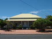
Jay Bee Day Care Centre
Bunbury
South West
Constructed from 1900
| Type | Status | Date | Documents |
|---|---|---|---|
| Heritage List | Adopted | 15 Apr 2003 |
| Type | Status | Date | Documents |
|---|---|---|---|
| RHP - To be assessed | Current | 14 Nov 2003 |
| Type | Status | Date | Grading/Management | |
|---|---|---|---|---|
| Category | ||||
| Municipal Inventory | Adopted | 31 Jul 1996 | High level of protection - TPS | |
05698 Stirling Street Heritage Precinct
Individual Building or Group
| Epoch | General | Specific |
|---|---|---|
| Original Use | RESIDENTIAL | Single storey residence |
| Present Use | SOCIAL\RECREATIONAL | Other Community Hall\Centre |
| Type | General | Specific |
|---|---|---|
| Roof | METAL | Corrugated Iron |
| Wall | TIMBER | Weatherboard |
This information is provided voluntarily as a public service. The information provided is made available in good faith and is derived from sources believed to be reliable and accurate. However, the information is provided solely on the basis that readers will be responsible for making their own assessment of the matters discussed herein and are advised to verify all relevant representations, statements and information.
Constructed from 1915
Charming timber and iron cottage which has been converted to use as a Day Care Centre. Sections have been enclosed at the rear of the building for under cover areas.
Stirling Street formed the northern boundary of Governor Stirling’s grant Location 26 of 100,000 acres). The street was first developed during the 1850s when several lots were granted to the Enrolled Pensioner Guards. The date of construction of House, 65 Stirling Street is not known. No entry could be found for the lot in the 1899 Rate Book and there are no rate books for the 1906 to 1920 period. It is thought that the house was built c. 1915. House, 65 Stirling Street was owned by the Hansen (or Hanson) family for many years. Christian Hansen was the owner and occupier in 1921 and in 1941, Thomas Hanson was the owner and Eliza Hanson the occupier. T A Hanson was listed as the owner in 1951. It was a rental property at this time. Tenants included A Porter and E Sacks. When the building was converted for use as a day care centre, changes included the construction of a high fence at the front of the property and the enclosure of sections of the rear to provide under cover play areas.
The building underwent some alteration when it was converted to a Child Care Centre. For practical reasons in line with its current use, a high fence has been erected at the front. A former corrugated iron awning over the front window was replaced with an eye-catching striped canvas awning. Essentially the original form is easily recognisable.
Exterior: Appears well maintained.
| Reserve | Lot/Location | Plan/Diagram | Vol/Folio |
|---|---|---|---|
| SL1 | S051040 | VOL996FOL128 |
This information is provided voluntarily as a public service. The information provided is made available in good faith and is derived from sources believed to be reliable and accurate. However, the information is provided solely on the basis that readers will be responsible for making their own assessment of the matters discussed herein and are advised to verify all relevant representations, statements and information.
70 Stirling St Bunbury
Bunbury
South West
Constructed from 1900
| Type | Status | Date | Documents |
|---|---|---|---|
| Heritage List | Adopted | 15 Apr 2003 |
| Type | Status | Date | Documents |
|---|---|---|---|
| RHP - To be assessed | Current | 14 Nov 2003 |
| Type | Status | Date | Grading/Management | |
|---|---|---|---|---|
| Category | ||||
| Municipal Inventory | Adopted | 31 Jul 1996 | High level of protection - TPS | |
05698 Stirling Street Heritage Precinct
Individual Building or Group
| Epoch | General | Specific |
|---|---|---|
| Original Use | RESIDENTIAL | Single storey residence |
| Present Use | RESIDENTIAL | Single storey residence |
| Type | General | Specific |
|---|---|---|
| Wall | BRICK | Common Brick |
| Roof | METAL | Corrugated Iron |
This information is provided voluntarily as a public service. The information provided is made available in good faith and is derived from sources believed to be reliable and accurate. However, the information is provided solely on the basis that readers will be responsible for making their own assessment of the matters discussed herein and are advised to verify all relevant representations, statements and information.
Constructed from 1900
House, 70 Stirling Street, a single storey brick and iron house has cultural heritage significance because it is a fine example of the Federation Queen Anne style of architecture, and it contributes to the aesthetic and precinctual qualities of Stirling Street.
House, 70 Stirling Street is a fine example of a single storey brick and iron house built in the Federation Queen Anne style of architecture. The walls are tuck pointed brick, with rendered brick to the sides, and above the verandah roof line. The roof is hipped with a gable to one end which has some decorative timber features. There is a tall brick corbelled chimney. The verandah has a dropped iron roof supported by timber posts with decorative timber brackets. There is an extra bullnose awning at the gable end. The asymmetrical façade has a faceted bay under the gable end, with timber framed double hung sash windows. The door has top and side lights and all windows and the door have a rendered architrave emphasis. There is a timber picket fence to the front boundary line.
Stirling Street formed the northern boundary of Governor Stirling’s grant Location 26 of 100,000 acres). The street was first developed during the 1850s when several lots were granted to the Enrolled Pensioner Guards. The date of construction of House, 70 Stirling Street is not known. No entry could be found for the lot in the 1899 Rate Book and there are no rate books for the 1906 to 1920 period. It is thought that the house was built c. 1900. House, 70 Stirling Street was owned by the Hislop family for many years. J Hislop was the owner and occupier in 1921. From c. 1930 until at least the early 1950s, House, 70 Stirling Street was owned and occupied by Henry Hislop.
The building remains largely as built, however a privacy lattice panel which once graced the front of the building has been removed.
Exterior: Good
| Reserve | Lot/Location | Plan/Diagram | Vol/Folio |
|---|---|---|---|
| 3 | P300632 435 | VOL1162FOL137 |
This information is provided voluntarily as a public service. The information provided is made available in good faith and is derived from sources believed to be reliable and accurate. However, the information is provided solely on the basis that readers will be responsible for making their own assessment of the matters discussed herein and are advised to verify all relevant representations, statements and information.
75 Stirling St Bunbury
Bunbury
South West
Constructed from 1920
| Type | Status | Date | Documents |
|---|---|---|---|
| Heritage List | Adopted | 15 Apr 2003 |
| Type | Status | Date | Documents |
|---|---|---|---|
| RHP - To be assessed | Current | 14 Nov 2003 |
| Type | Status | Date | Grading/Management | |
|---|---|---|---|---|
| Category | ||||
| Municipal Inventory | Adopted | 31 Jul 1996 | High level of protection - TPS | |
05698 Stirling Street Heritage Precinct
Individual Building or Group
| Epoch | General | Specific |
|---|---|---|
| Original Use | RESIDENTIAL | Single storey residence |
| Present Use | RESIDENTIAL | Single storey residence |
| Type | General | Specific |
|---|---|---|
| Wall | BRICK | Common Brick |
| Roof | METAL | Corrugated Iron |
This information is provided voluntarily as a public service. The information provided is made available in good faith and is derived from sources believed to be reliable and accurate. However, the information is provided solely on the basis that readers will be responsible for making their own assessment of the matters discussed herein and are advised to verify all relevant representations, statements and information.
Constructed from 1915
House, 75 Stirling Street, a single storey brick and iron house has cultural heritage significance because it is a typical example of the Federation Bungalow style of architecture, and it contributes to the aesthetic and precinctual qualities of Stirling Street.
House, 75 Stirling Street is a single storey brick and iron house constructed in the Federation Bungalow style of Architecture. The walls are rendered. The roof is hipped and clad with zincalume. The asymmetrical front façade has a protruding front room with timber framed windows. The house is situated at street level. There is a high face brick wall to the front boundary line. This prevents further description of the front elevation.
Stirling Street formed the northern boundary of Governor Stirling’s grant Location 26 of 100,000 acres). The street was first developed during the 1850s when several lots were granted to the Enrolled Pensioner Guards. The date of construction of House, 75 Stirling Street is not known. No entry could be found for the lot in the 1899 Rate Book and there are no rate books for the 1906 to 1920 period. It is thought that the house was built c. 1915. In 1921, House 75 Stirling Street was owned by N Moore and occupied by B Morrison, a marine dealer. N Moore was still the owner in 1931. By 1941, House, 75 Stirling Street was owned by William Ratcliffe and occupied by James Gorey and then Arthur Hewins. In 1951, the house was listed as being owned by Ratcliffe’s estate. Arthur Hewins still lived there at the time.
The building is presumed largely in original form although visually obscured from the street by a high brick wall.
Exterior: Appears good.
| Reserve | Lot/Location | Plan/Diagram | Vol/Folio |
|---|---|---|---|
| 15 | P001325 15 |
This information is provided voluntarily as a public service. The information provided is made available in good faith and is derived from sources believed to be reliable and accurate. However, the information is provided solely on the basis that readers will be responsible for making their own assessment of the matters discussed herein and are advised to verify all relevant representations, statements and information.
77-79 Stirling St Bunbury
Stirling Villas
Bunbury
South West
Constructed from 1914
| Type | Status | Date | Documents |
|---|---|---|---|
| (no listings) |
| Type | Status | Date | Documents |
|---|---|---|---|
| RHP - To be assessed | Current | 14 Nov 2003 |
| Type | Status | Date | Grading/Management | |
|---|---|---|---|---|
| Category | ||||
| Municipal Inventory | Adopted | 31 Jul 1996 | SITE of previous bldg - recognise only | |
05698 Stirling Street Heritage Precinct
Historic Site
| Epoch | General | Specific |
|---|---|---|
| Present Use | RESIDENTIAL | Single storey residence |
| Original Use | RESIDENTIAL | Single storey residence |
| Type | General | Specific |
|---|---|---|
| Roof | METAL | Corrugated Iron |
This information is provided voluntarily as a public service. The information provided is made available in good faith and is derived from sources believed to be reliable and accurate. However, the information is provided solely on the basis that readers will be responsible for making their own assessment of the matters discussed herein and are advised to verify all relevant representations, statements and information.
Constructed from 1914
DEMOLISHED The large residence was built by Dr. Joel c1914 for a hospital but was never used for that purpose.
Building was an attractive timber and iron homestead with wide verandahs on at least three sides. At either side of the verandah were privacy lattice screens enhancing the symmetry of the place.
The building at 77-79 Stirling Street was built on a large block for Dr Joel, a well known local medical practitioner, who intended to use the property as a hospital. However, his scheme did not eventuate. The house was a large, attractive timber and iron homestead on timber stumps, with wide timber verandah wrapping around at least three sides. At either end of the front verandah, lattice screens were place to provide a degree of privacy. The house was demolished in the 1990s to make way for a block of brick residential units (Stirling Villas).
DEMOLISHED.
No visible remains.
This information is provided voluntarily as a public service. The information provided is made available in good faith and is derived from sources believed to be reliable and accurate. However, the information is provided solely on the basis that readers will be responsible for making their own assessment of the matters discussed herein and are advised to verify all relevant representations, statements and information.
82 Stirling St Bunbury
To be assessed as part of P5698 Stirling Street Heritage Precinct
Bunbury
South West
Constructed from 1875
| Type | Status | Date | Documents |
|---|---|---|---|
| Heritage List | Adopted | 15 Apr 2003 |
| Type | Status | Date | Documents |
|---|---|---|---|
| RHP - To be assessed | Current | 14 Nov 2003 | |
| RHP - Assessed - Below Threshold | Current | 28 Jun 1996 |
| Type | Status | Date | Grading/Management | |
|---|---|---|---|---|
| Category | ||||
| Municipal Inventory | Adopted | 31 Jul 1996 | Recommend RHP | |
| Register of the National Estate | Permanent | 28 Sep 1982 | ||
| Classified by the National Trust | Classified | 04 Aug 1980 | ||
05698 Stirling Street Heritage Precinct
Individual Building or Group
| Epoch | General | Specific |
|---|---|---|
| Original Use | RESIDENTIAL | Single storey residence |
| Present Use | RESIDENTIAL | Single storey residence |
| Style |
|---|
| Victorian Georgian |
| Type | General | Specific |
|---|---|---|
| Wall | BRICK | Handmade Brick |
| Roof | METAL | Corrugated Iron |
This information is provided voluntarily as a public service. The information provided is made available in good faith and is derived from sources believed to be reliable and accurate. However, the information is provided solely on the basis that readers will be responsible for making their own assessment of the matters discussed herein and are advised to verify all relevant representations, statements and information.
Constructed from 1875
House, 82 Stirling Street, a single storey brick and iron house built in the Victorian Georgian style of architecture, has cultural heritage significance because: the place was built for Daniel North, who was one of several ex-convicts that became successful businessmen and well respected citizens in Bunbury in the late 1800s; the place is one of a series of early houses which is a typical example of building from this period; and the place contributes to the aesthetic and precinctual qualities of Stirling Street.
House, 82 Stirling Sreet is a single storey, brick and iron house designed as an example of the Victorian Georgian style of architecture. The walls are rendered to dado height and painted brick above. The roof is hipped and clad with zincalume. There are two rendered corbelled chimneys evident. The façade is symmetrical with a central front door with sidelights flanked on either side by timber framed windows. The verandah has a separate dropped iron roof supported by timber posts with decorative timber brackets. There is a brick pier and rail fence to the front boundary line. There is a substantial rear addition, and a side carport.
Stirling Street formed the northern boundary of Governor Stirling’s grant Location 26 of 100,000 acres). The street was first developed during the 1850s when several lots were granted to the Enrolled Pensioner Guards. House, 82 Stirling Street was built c 1875 for Daniel North, a local businessman. Daniel North came to Western Australia aboard the convict ship ‘William Jardine’ in August 1852. He had been convicted of larceny in Taunton, Somerset, and sentenced to 10 years transportation. North received his ticket-of-leave in February 1854 and a conditional pardon in 1856. In 1853, he applied for his wife Eliza and child to join him in Western Australia. By the 1860s, North was farming in the Dardanup area and went on to establish a successful carting and road making business. He frequently employed ticket-of-leave men and owned several properties in the Bunbury town. House, 82 Stirling Street was originally built as a simple two roomed cottage separated by a passage. It was constructed using hand-made bricks laid in a solid Flemish bond pattern. A rear addition was constructed in the 1880s. In 1899, Daniel North still owned the property, which was occupied by Richard Wall (?), a labourer at the time. The addition created an M-shaped roof, which was used at the time to maintain a steep roof of low profile and the valley gutter was closed off from the street elevation with a return ridge, which was a precursor to the modern double hipped roof form. From c 1935 to until the early 1950s, House, 82 Stirling Street was owned and occupied by Vera Sinclair. Sometime between the late 1970s and early 1990s, a brick pier and rail fence was built across the front of the property and former block verandah piers were replaced with slender posts with decorative brackets.
One of a series of early houses which is a typical example of building from this period. The building reflects a graciousness and is visually appealing from the street.
Exterior: Good and well-maintained.
| Reserve | Lot/Location | Plan/Diagram | Vol/Folio |
|---|---|---|---|
| 2 | D002097 2 |
This information is provided voluntarily as a public service. The information provided is made available in good faith and is derived from sources believed to be reliable and accurate. However, the information is provided solely on the basis that readers will be responsible for making their own assessment of the matters discussed herein and are advised to verify all relevant representations, statements and information.
84 Stirling St Bunbury
Bunbury
South West
Constructed from 1880 to 1890
| Type | Status | Date | Documents |
|---|---|---|---|
| Heritage List | Adopted | 15 Apr 2003 | |
| State Register | Registered | 02 Sep 1997 | HCWebsite.Listing+ListingDocument, HCWebsite.Listing+ListingDocument |
| Type | Status | Date | Documents |
|---|---|---|---|
| (no listings) |
| Type | Status | Date | Grading/Management | |
|---|---|---|---|---|
| Category | ||||
| Classified by the National Trust | Classified | 04 Aug 1980 | ||
| Register of the National Estate | Permanent | 28 Sep 1982 | ||
| Municipal Inventory | Adopted | 31 Jul 1996 | Recommend RHP | |
05698 Stirling Street Heritage Precinct
Individual Building or Group
| Epoch | General | Specific |
|---|---|---|
| Present Use | RESIDENTIAL | Single storey residence |
| Original Use | RESIDENTIAL | Single storey residence |
| Style |
|---|
| Victorian Georgian |
| Type | General | Specific |
|---|---|---|
| Roof | METAL | Corrugated Iron |
| Wall | BRICK | Common Brick |
| General | Specific |
|---|---|
| DEMOGRAPHIC SETTLEMENT & MOBILITY | Land allocation & subdivision |
| SOCIAL & CIVIC ACTIVITIES | Government & politics |
| SOCIAL & CIVIC ACTIVITIES | Education & science |
| PEOPLE | Famous & infamous people |
This information is provided voluntarily as a public service. The information provided is made available in good faith and is derived from sources believed to be reliable and accurate. However, the information is provided solely on the basis that readers will be responsible for making their own assessment of the matters discussed herein and are advised to verify all relevant representations, statements and information.
SIGNIFICANCE: Significant as an illustration of evolution of a town house form, of good architectural quality and forming part of a precinct, in Stirling Street, of various typical house forms.
A house with double-hipped roof, with the front closing and concealing the roof valley, illustrating the evolution of a common roof form from the random results of expedient additions to be seen in the adjacent house at No 82. Decorated barge boards are of the same type seen earlier at "Leschenault" and 15 Casey Street. The concave, belled verandah roof is of a typical type preceding the bullnosed type. With the development of the main roof type a broad plan, with rooms flanking a central passage, replaced the early vernacular rectangular cottage form. Recently restored. Circa 1880 - 90.
Assessment 1980 Construction: 1880-90
This information is provided voluntarily as a public service. The information provided is made available in good faith and is derived from sources believed to be reliable and accurate. However, the information is provided solely on the basis that readers will be responsible for making their own assessment of the matters discussed herein and are advised to verify all relevant representations, statements and information.
Constructed from 1890, Constructed from 1950
House at 84 Stirling Street, a single-storey brick and iron residence, has cultural heritage significance for the following reasons: it is an elegant, harmonious and picturesque dwelling, forming part of the edge to the scenic Leschenault Inlet foreshore in Stirling Street, and part of the Stirling Street precinct; it demonstrates the turn-of-the-century expansion of the suburbs of Bunbury along the Inlet, following the gradual subdivision of the historic Stirling estate (Location 26); and is an example of a developed form of late nineteenth century cottage, at a turning point of stylistic development in the history of Western Australian domestic architecture; it has a close association with George Robert Teede, first Government School teacher and first Clerk of the Town in Bunbury; it has scientific value as a teaching site with respect to the class of elementary early Western Australian houses; and, it contributes to the visual coherence and historic authenticity of the Stirling Street-Austral Parade precinct, as an urban space contributing to the community's sense of place in Bunbury. Extracted from the Documentary Evidence in Heritage Council of Western Australia's Assessment Documentation for 'House at 84 Stirling Street', prepared by Ian Molyneux, 1997.
House, 84 Stirling Street, is a single storey (with two storey addition) brick and iron house built in the Victorian Georgian style of architecture. The walls are painted brick. The roof is hipped and clad with Colourbond. The double hipped roof illustrates the evolution of the common roof form resulting from random additions as seen in adjacent house (No 82). The roof has scalloped timber gutter-boards and a concave, belled, dropped verandah roof which was common before the introduction of the bull-nosed corrugated iron verandah in the 1890s. The facade is symmetrical with a central door with top and side lights, flanked either side by large timber framed double hung sash windows.The verandah is wide and wraps around both sides of the house, supported by timber posts. There are substantial rear two storey additions, however the original form of the house remains intact from the street.
Stirling Street formed the northern boundary of Governor Stirling’s grant Location 26 of 100,000 acres). The street was first developed during the 1850s when several lots were granted to the Enrolled Pensioner Guards. House at 84 Stirling Street is a single-storey residence constructed in c.1880-1900, as a private residence. Unsubstantiated data provided by the Bunbury Historical Society to the National Trust of Australia (WA), in 1975, names the structure 'House – Bin Teede - 1900s', referring to Binsted Teede, a son of George Robert Teede. The date given does not fit with the extant physical stylistic evidence of the belled verandah roof and scalloped gutter boards, but this may reflect later modification of the physical evidence. House at 84 Stirling Street is associated with the Teede family, descendants of the first Town Clerk, George Robert Teede. An immigrant to Australind on the Diadem with the Western Australian Land Company in 1842, and son of the teacher at York, Teede was a prominent citizen through his positions as first head teacher of the Government School (1862-), Clerk to the Town Trust (1870-71) and Town Clerk (1871-96). The documentary evidence of the development of Leschenault Location 26, Stirling's vast South Bunbury-Picton estate, as the contextual locality for the place, is summarised in 'The Lower Preston River Settlement'. House at 84 Stirling Street represents suburban Bunbury immediately outside the south-eastern most edge of the townsite confined by Stirling's land selection, a locality that fits the description of a 600 acre parcel of land sold in 1841, and is a part of the turn-of-the-century precinct of houses that follow Stirling Street and Austral Parade (formerly 'White Road'); roads which follow the northern boundary of Stirling's Location 26. The street came to prominence with the division during the gold boom era, into suburban housing lots, of those 10 and 20 acre farming and market gardening lots into which Location 26 had been divided. Such small fringe farms typically then succumbed to the growth of the town of Bunbury. The present title, replacing any earlier form of title, was issued to Kenneth Noel Teede, mechanic of Stirling Street, Bunbury on 27 July 1948, from whom it passed to Mr and Mrs Ross Newburn Elliott in 1975, then to Mr and Mrs Peter Douglas Horn in 1977, and lastly to be occupied by Mr John Myers, solicitor and barrister of Bunbury, and his wife, from 1981. Mrs Myers puts the rear, north-eastern living room date as circa 1950 (therefore attributed to Mr K. N. Teede) and additions and alterations were carried out to the north-west corner by the Myers in about 1982. In 1996, House at 84 Stirling Street continues to be used for residential purposes. This history is extracted from the Documentary Evidence in Heritage Council of Western Australia's Assessment Documentation for 'House at 84 Stirling Street', prepared by Ian Molyneux, 1997.
Although the building is restored, its form remains largely original.
Exterior: Good
| Reserve | Lot/Location | Plan/Diagram | Vol/Folio |
|---|---|---|---|
| 1 | D013729 1 | VOL1111FOL659 |
This information is provided voluntarily as a public service. The information provided is made available in good faith and is derived from sources believed to be reliable and accurate. However, the information is provided solely on the basis that readers will be responsible for making their own assessment of the matters discussed herein and are advised to verify all relevant representations, statements and information.
Lot 51 Stirling St Bunbury
Bunbury
South West
| Type | Status | Date | Documents |
|---|---|---|---|
| (no listings) |
| Type | Status | Date | Documents |
|---|---|---|---|
| (no listings) |
| Type | Status | Date | Grading/Management | |
|---|---|---|---|---|
| Category | ||||
| (no listings) | ||||
Individual Building or Group
| Epoch | General | Specific |
|---|---|---|
| Present Use | RESIDENTIAL | Single storey residence |
| Original Use | RESIDENTIAL | Single storey residence |
This information is provided voluntarily as a public service. The information provided is made available in good faith and is derived from sources believed to be reliable and accurate. However, the information is provided solely on the basis that readers will be responsible for making their own assessment of the matters discussed herein and are advised to verify all relevant representations, statements and information.
Lot 534 Stirling St Bunbury
Stirling Street Arts Centre
Bunbury
South West
Constructed from 1917
| Type | Status | Date | Documents |
|---|---|---|---|
| Heritage List | Adopted | 15 Apr 2003 |
| Type | Status | Date | Documents |
|---|---|---|---|
| RHP - Assessed - Below Threshold | Current | 24 Feb 2017 |
| Type | Status | Date | Grading/Management | |
|---|---|---|---|---|
| Category | ||||
| Municipal Inventory | Adopted | 31 Jul 1996 | Exceptional Significance | |
05698 Stirling Street Heritage Precinct
State Government Infants’ School (fmr), Bunbury, comprising an Inter-War Georgian Revival brick and corrugated iron former Bunbury Infants’ School (1917), brick and corrugated iron Toilet Block (1948), and mature trees has cultural heritage significance for the following reasons: the place demonstrates the development of education in the State in the early twentieth century, particularly in relation to the expansion of regional areas; the place is an example of the implementation of innovative teaching methods in Western Australia associated with Maria Montessori between 1914 and the 1920s; the place is associated with PWD Chief Architect Hillson Beasley, and his successor, William Burden Hardwick having been based on a standard plan for Infant Schools incorporating ‘open-air’ teaching methods, which was used at a number of other schools in the State; The Bunbury Band Hall (1974), Creche (1975), Pottery Studio (1976), Undercover Area (2009), and Storage Area (2010) associated with the site’s use as Stirling Street Arts Centre are considered to have little cultural heritage significance.
The Bunbury Infants’ School is a single storey stretcher-bond red brick Inter-War Georgian Revival style building with long-sheet corrugated iron roofing. The building lacks some symmetrical characteristics of this style owing to the protruding bays on the southern elevation being reflective of the interior layout. The Toilet Block is located north of the original Bunbury Infants’ School building and is constructed of face brick and has a simple hipped form roof clad in corrugated iron.
Between 1895 and 1898, with the allocation of land for the railway station complete, the original girls’ and infants’ school on Lot 284 was demolished and a new infants’ school constructed,13 which relieved the pressure on the Bunbury Mixed School. However, in 1917, there were 150 students at the infants’ school, making the facility overcrowded and the local community voiced their concerns. The Minister for Education subsequently approved the construction of a new infants’ school when suitable land became available. After 1912, Chief Architect Hillson Beasley had created a standard plan for school buildings that aimed to meet the criteria of a popular phase in early twentieth century teaching methods known as Montessori. In August 1917, the plans for the extant Bunbury Infants’ School building were adapted from the standard Beasley design by Beasley’s successor as Chief Architect, W. B. Hardwick. The allocation of land for the new school comprised Lots P7 and P8, which had been reclaimed from the lagoon for the construction of the railway. On 3 August 1917, tenders for the school’s construction were called and the contract was awarded to J. G. Hough on 28 August 1917. In November 1947, tenders were called for the toilet and sewerage construction and the contract was awarded to C. R. Gibson for £740. The brick and iron infants’ toilet block was completed in July 1948. During the 1960s, Western Australia’s education system phased out the concept of infants’ schools in place of the primary school system. In 1967, State Government Infants’ School (fmr), Bunbury closed and the students were dispersed between Bunbury Central Primary, Eaton Primary, and Cooinda Primary schools.
| Library Id | Title | Medium | Year Of Publication |
|---|---|---|---|
| 11495 | Conservation management plan for the State government infants' school (fmr), Stirling Street, cnr Charles Street, Bunbury (now known as the Stirling Street Arts Centre). | Book | 2016 |
| 7299 | Bunbury images : people and places. | Book | 2004 |
Individual Building or Group
| Epoch | General | Specific |
|---|---|---|
| Present Use | SOCIAL\RECREATIONAL | Other Community Hall\Centre |
| Original Use | EDUCATIONAL | Primary School |
| Style |
|---|
| Inter-War Georgian Revival |
| Type | General | Specific |
|---|---|---|
| Wall | BRICK | Common Brick |
| Roof | METAL | Corrugated Iron |
| General | Specific |
|---|---|
| SOCIAL & CIVIC ACTIVITIES | Government & politics |
| SOCIAL & CIVIC ACTIVITIES | Education & science |
This information is provided voluntarily as a public service. The information provided is made available in good faith and is derived from sources believed to be reliable and accurate. However, the information is provided solely on the basis that readers will be responsible for making their own assessment of the matters discussed herein and are advised to verify all relevant representations, statements and information.
Constructed from 1962, Constructed from 1918
State Government Infants' School (fmr), a single storey face brick and iron building has cultural heritage significance for the following reasons: the place is representative of one of the more important school designs prepared by the Public Works Department in the 1910s, authored by Hillson Beasley. Its innovative design served as a model on which several other schools were based; the place is a substantial building designed in the Georgian Revival style of architecture, and has aesthetic value for its design and detailing; the place is representative of the development of education facilities in Bunbury, and reflects the development that occurred in the history of primary education in the State in this period; the place has landmark qualities and contributes significantly to the streetscape and the community's sense of place; and the place has played a central and continuing role in the education of Bunbury residents since its establishment in 1917 as the Bunbury Infants' School. It was then a TAFE campus and since 1989, has housed a recreational and educational arts and crafts centre.
State Government Infants School (fmr) is a single storey face brick and iron building constructed in the Georgian Revival style of architecture. The walls are face brick and the roof is hipped with gables over the slightly projecting bays. Tall face brick chimneys are situated either side of the gables. Each gabled projecting section has three tall double hung sash windows with high lights above.
Bunbury Infants School opened in 1918. It was built in response to the overcrowding at the Bunbury Public School, which had been completed in 1898. The new infants’ school was built on the opposite side of the railway tracks from Bunbury Public School. It was located on the corner of Stirling and James Street on land purchased from Mr Connor and the Roman Catholic Church. The school was built by J G Hough for the contract price of £2,394/17/1. Although the contract was not due for completion until February 1918, Mr Hough handed the keys over to the head teacher, Miss E Millicent, on 8 December 1917. The school comprised a row of four class rooms with generous floor space, linked by an open verandah with cloak rooms at either end. The rooms catered for Lower Infants, Upper Infants and Standards 1 and 2. An open verandah at the rear provided outdoor teaching space. Students accessed the school via a timber footbridge over the railway line. Many former students recall the excitement of crossing the railway line, especially when steam trains passed underneath and blew their whistles. Bunbury Infant School operated until 1962 when the new Bunbury Central Primary School was built in Lovegrove Avenue. The former infant’s school then became part of the Bunbury TAFE (Tertiary and Further Education). In 1976, TAFE students built a pottery room using material from the original school buildings (which were situated on what is now the car park near the Paisley Centre). From 1981 to 1984, the former Bunbury Infants School was leased by Bunbury Technical College for art classes and was re-named the Bunbury Arts Centre. In 1989 the name was again changed – this time to the Stirling Street Arts Centre. Although the centre started with only three art classes, over the years it has grown in popularity and in 2009 provides a range of arts and crafts facilities, with 17 groups (representing 370 members) meeting there on a regular basis.
High degree of integrity (original intent clear, current use compatible, high long term sustainability). High degree of authenticity with much original fabric remaining. (These statements based on street survey only).
Condition assessed as good (assessed from streetscape survey only).
| Reserve | Lot/Location | Plan/Diagram | Vol/Folio |
|---|---|---|---|
| 534 | P188249 534 | VOLLR300FOL122 |
This information is provided voluntarily as a public service. The information provided is made available in good faith and is derived from sources believed to be reliable and accurate. However, the information is provided solely on the basis that readers will be responsible for making their own assessment of the matters discussed herein and are advised to verify all relevant representations, statements and information.
Stirling St between Blair St & Albert Rd Bunbury
also includes house at 38 Charles St Includes Park, Morre, Ednie, Thomas, Braund & Hayes Sts
East Bunbury Heritage Area
Bunbury
South West
Constructed from 1875 to 1925
| Type | Status | Date | Documents |
|---|---|---|---|
| (no listings) |
| Type | Status | Date | Documents |
|---|---|---|---|
| RHP - To be assessed | Current | 14 Nov 2003 |
| Type | Status | Date | Grading/Management | |
|---|---|---|---|---|
| Category | ||||
| (no listings) | ||||
The place has aesthetic value for its simple buildings with hipped and gabled roofs create interesting streetscapes, and their green leafy setting along a protected body of water provides a picturesque residential area.
The precinct is one of few residential areas adjacent a city that contains such a comprehensive stock of late Victorian and Federation buildings.
The place has historic associations with the development of Bunbury since the mid nineteenth century. The precinct is indicative of Bunbury’s early residential development.
The precinct is predominantly a late 19th century residential area, planned in a relatively informal manner along the Leschenault Inlet, with its main internal arterial roads running east to west. Stirling Street precinct is sited along the southern edge of the Leschenault Inlet, and covers an area of approximately 2.0km square. It is bound to the east and west by Blair Street and King Road respectively, with Mervyn Street and Herbert Road forming its southern boundary. Its planning form remains largely intact, including its leafy character and open foreshore to the north, with the major areas of change consisting of hard landscape elements such as the bitumised roads, curbing, power poles etc,. The precinct contains around 200 residences. The north and eastern parts of the Precinct comprises a mixture of predominantly single storey timber framed and masonry buildings on individual lots, as well as a few grouped dwellings, the Red Mill Store and the Parade Hotel. Its character is largely formed by the overall simplicity of the form, scale and detailing of the buildings, with their picturesque pitched and gabled roofs within a leafy domestic garden setting. The western portion of the precinct, as described above, has been largely redeveloped. While the overall condition of the precinct is generally good, the condition of individual buildings varies enormously, with ongoing development pressure resulting in new additions, conservation and some demolition. The buildings are predominantly of the late Victorian and Federation periods, and collectively reflect a simple vernacular form of timber and masonry residential design with a scale and symmetry that can be traced to the Victorian Georgian style of architecture.
‘The Stirling Street Precinct evolved out of the gradual subdivision of the historic land grant, Location 26, which Governor Sir James Stirling took up in lieu of wages in 1830. The huge grant of 3940 acres straddled the Preston River and hemmed in the townsite of Bunbury [Port Leschenault]. In the late 1850s, the northern side of White Road [now Stirling Street], was divided into 1 acre Pensioner Lots, allocated by captain Bruce to those Pensioner Guards who volunteered to relieve the post garrisoned by the Bunbury detachment of the 99th Regiment at Australind in 1851. Initially the Guards were housed in the old Military Barracks until they had built their own cottages with Government assistance of £15 towards costs incurred. The scheme proved sound judgement on the part of Captain Bruce as he could report to the Governor in 1852, the success of the scheme and the satisfaction expressed by the eight pensioners. During the 1890s, the former Stirling Estate, now administered by inheritors and known locally as the Stirling-Mangles Estate, was sold as suburban lots along Stirling Street and the Inlet shores. The precinct represents the initial expansion of Bunbury beyond the townsite area to the gradual development of suburbs at East Bunbury and Rathmines. South Bunbury would soon follow and the Council would divide into Central, North and South Wards during the 1890s. Many allotments were subdivided down from earlier small farms and market gardens. Today, the built heritage of the Precinct comprises a cross section of Bunbury suburban homes ranging between the years1875 to pre-WW1. many dwellings are vernacular bungalow and cottage forms built for families whose main occupations could well have been associated with maritime, lumper or railway activities. A number of successful businessmen built graceful villas in the area. They must have experienced the advantage of residing in close proximity to the town and their workplaces/businesses.’
Integrity- High Authenticity- Moderate
Good
| Library Id | Title | Medium | Year Of Publication |
|---|---|---|---|
| 7473 | Stirling Street heritage precinct : draft conservation policy and design guidelines. | Heritage Study {Other} | 1999 |
Precinct or Streetscape
| Epoch | General | Specific |
|---|---|---|
| Original Use | RESIDENTIAL | Conjoined residence |
| Present Use | RESIDENTIAL | Other |
| Original Use | RESIDENTIAL | Single storey residence |
| Original Use | RESIDENTIAL | Terrace housing |
| Type | General | Specific |
|---|---|---|
| Wall | BRICK | Common Brick |
| General | Specific |
|---|---|
| DEMOGRAPHIC SETTLEMENT & MOBILITY | Settlements |
This information is provided voluntarily as a public service. The information provided is made available in good faith and is derived from sources believed to be reliable and accurate. However, the information is provided solely on the basis that readers will be responsible for making their own assessment of the matters discussed herein and are advised to verify all relevant representations, statements and information.
Stirling St near Albert Rd Bunbury
Bunbury
South West
Constructed from 1838 to 1841
| Type | Status | Date | Documents |
|---|---|---|---|
| Heritage List | Adopted | 15 Apr 2003 |
| Type | Status | Date | Documents |
|---|---|---|---|
| RHP - To be assessed | Current | 14 Nov 2003 |
| Type | Status | Date | Grading/Management | |
|---|---|---|---|---|
| Category | ||||
| Municipal Inventory | Adopted | 31 Jul 1996 | Historic Site | |
05698 Stirling Street Heritage Precinct
Historic Site
| Epoch | General | Specific |
|---|---|---|
| Original Use | OTHER | Other |
| Type | General | Specific |
|---|---|---|
| Other | STONE | Other Stone |
| General | Specific |
|---|---|
| DEMOGRAPHIC SETTLEMENT & MOBILITY | Exploration & surveying |
This information is provided voluntarily as a public service. The information provided is made available in good faith and is derived from sources believed to be reliable and accurate. However, the information is provided solely on the basis that readers will be responsible for making their own assessment of the matters discussed herein and are advised to verify all relevant representations, statements and information.
Constructed from 1838 to 1841
DEMOLISHED In 1838 contract surveyor Thomas Watson recorded that he had placed Bunbury Townsite Survey Peg No 1, the first wooden peg placed for the cadastral survey to lay out the townsite of Bunbury, at Meredith Creek. Watson's work was later re-surveyed and extended by Assistant Surveyor, H.M. Ommanney in 1841, who is attributed with surveying the Bunbury townsite.
DEMOLISHED
Survey Peg No 1 for the Bunbury Townsite was placed in the middle of Meredith Creek by Surveyor Thomas Watson under a Colonial Government contract in 1838. However, Watson’s survey work was largely abandoned and it was not until 1841 that Assistant Surveyor H M Ommaney, under instruction from Surveyor General J S Roe, began a full survey. Ommaney noted in his journal that “Mr Watson’s southern boundary appears to commence at a post situated 1 chain south from the middle of the creek’s mouth.’ The earlier boundaries of Stiring’s Leschenault Location 26 of 3,940 acres resulted in two pegs being placed at easily identifiable locations – the first where Meredith Creek enters the Estuary and the second at the junction of the Preston River and Eedle Creek. During Ommaney’s survey, Peg No 1 was marked on the ground by a 9 foot high pole set up about four links from the left bank of the creek, from which the east/west lines ran through until they reached the ocean on the west side and the Collie River, or other property, to the east. It is not known if the survey peg was removed or disintegrated. In 1988, a cairn and plaque were placed near the site of the Survey Peg No 1 as part of the Bicentennial celebrations. The plaque has since been removed and its location is not known. The cairn remains in place.
1988 Bicentennial Plaque commemorates the site of Bunbury Survey Peg No 1. However, while the cairn remains, the metal plaque has been removed by person or persons unknown.
No visible remains.
This information is provided voluntarily as a public service. The information provided is made available in good faith and is derived from sources believed to be reliable and accurate. However, the information is provided solely on the basis that readers will be responsible for making their own assessment of the matters discussed herein and are advised to verify all relevant representations, statements and information.
Stirling St nr Arthur St Bunbury
First Govt Hospital & School site
Subway Restaurant, Moreton Bay Fig Tree
Bunbury
South West
Constructed from 1851 to 1853
| Type | Status | Date | Documents |
|---|---|---|---|
| Heritage List | Adopted | 15 Apr 2003 |
| Type | Status | Date | Documents |
|---|---|---|---|
| (no listings) |
| Type | Status | Date | Grading/Management | |
|---|---|---|---|---|
| Category | ||||
| Municipal Inventory | Adopted | 31 Jul 1996 | Historic Site | |
Historic Site
| Epoch | General | Specific |
|---|---|---|
| Original Use | GOVERNMENTAL | Other |
| Present Use | GOVERNMENTAL | Other |
| Style |
|---|
| Victorian Colonial |
| General | Specific |
|---|---|
| DEMOGRAPHIC SETTLEMENT & MOBILITY | Workers {incl. Aboriginal, convict} |
This information is provided voluntarily as a public service. The information provided is made available in good faith and is derived from sources believed to be reliable and accurate. However, the information is provided solely on the basis that readers will be responsible for making their own assessment of the matters discussed herein and are advised to verify all relevant representations, statements and information.
Constructed from 1853, Constructed from 1851
DEMOLISHED The Convict Depot and Commissariat formed part of the infrastructure developed in Bunbury to supervise and accommodate the convicts assigned to Bunbury in the 1850s and 1860s. The convicts provided a much needed boost to the population and workforce for farms and public projects such as road building. At the same time, they helped boost the local economy by consuming goods and using local services. Several convicts assigned to Bunbury went on to become successful and well respected citizens. The buildings were later used as the first govenment school in Bunbury.
DEMOLISHED
The Bunbury Convict Depot was built in the 1850s to a design by Henry Trigg of the Royal Engineers. It was a brick building built by private and contract labour to accommodate the Commissariat and Hiring Depot. The first group of convicts arrived in Bunbury in 1851 and they were a prominent presence in Bunbury through the 1850s and 1860s. Many went on to become prominent citizens. The convicts provided a welcome boost to the local economy, as noted by the Reverend Wollaston in 1853, when he referred to the Hiring Depot for ticket of leave men, the pensioner guard cottages, and a fine, new convict built lockup in his diary. He also mentioned new buildings, roads, bridges and land clearances. Only male convicts were transported to Western Australia and they provided both labour and a boost in population. After the Convict Depot closed, the building and site was used as a government school for some years.
DEMOLISHED
DEMOLISHED
This information is provided voluntarily as a public service. The information provided is made available in good faith and is derived from sources believed to be reliable and accurate. However, the information is provided solely on the basis that readers will be responsible for making their own assessment of the matters discussed herein and are advised to verify all relevant representations, statements and information.
NE Cnr Stirling St nr Arthur St Bunbury
verge nr Target Shoppers Car Park
Ficus macrophylla
Bunbury
South West
| Type | Status | Date | Documents |
|---|---|---|---|
| (no listings) |
| Type | Status | Date | Documents |
|---|---|---|---|
| (no listings) |
| Type | Status | Date | Grading/Management | |
|---|---|---|---|---|
| Category | ||||
| Municipal Inventory | Adopted | 31 Jul 1996 | Moderate Significance | |
| Classified by the National Trust | Classified | |||
Tree
| Epoch | General | Specific |
|---|---|---|
| Present Use | SOCIAL\RECREATIONAL | Other |
| Original Use | SOCIAL\RECREATIONAL | Other |
| General | Specific |
|---|---|
| SOCIAL & CIVIC ACTIVITIES | Environmental awareness |
| PEOPLE | Famous & infamous people |
This information is provided voluntarily as a public service. The information provided is made available in good faith and is derived from sources believed to be reliable and accurate. However, the information is provided solely on the basis that readers will be responsible for making their own assessment of the matters discussed herein and are advised to verify all relevant representations, statements and information.
Moreton Bay Fig Tree, Stirling Street, has cultural heritage significance because: It is a prominant landmark in the Bunbury Central Business District. It has social and historic value being depicted in a painting by well-known artist, Leith Angelo. It has rarity value as a significant tree in the central Bunbury area.
The Moreton Bay Fig Tree is located on verge near the Target Shoppers Car Park in the CBD. The tree is a large, sturdy, glossy-leafed tree with grey trunk. It is an excellent shade tree producing soft fig-shaped fruit which fall as they ripen.
The Moreton Bay Fig is a substantial specimen and is one of the few mature trees remaining in the Central Business District. This tree has been the subject of a well-known painting by artist, Leith Angelo [early member Bunbury Art Society] which is part of the Parliament House Collection in Perth.
Lopped regularly as the foliage spreads a distance over the Street. Appears well-maintained by Council staff.
This information is provided voluntarily as a public service. The information provided is made available in good faith and is derived from sources believed to be reliable and accurate. However, the information is provided solely on the basis that readers will be responsible for making their own assessment of the matters discussed herein and are advised to verify all relevant representations, statements and information.
28-30 Stirling Street Bunbury
Colonial House
Bunbury
South West
| Type | Status | Date | Documents |
|---|---|---|---|
| Heritage List | Adopted | 31 Jan 2023 |
| Type | Status | Date | Documents |
|---|---|---|---|
| (no listings) |
| Type | Status | Date | Grading/Management | |
|---|---|---|---|---|
| Category | ||||
| Local Heritage Survey | Adopted | 31 Jan 2023 | Considerable Significance | |
Individual Building or Group
| Epoch | General | Specific |
|---|---|---|
| Original Use | COMMERCIAL | Shop\Retail Store {single} |
| Present Use | COMMERCIAL | Other |
| Style |
|---|
| Federation Free Classical |
| Victorian Georgian |
| Type | General | Specific |
|---|---|---|
| Wall | BRICK | Rendered Brick |
| Roof | METAL | Corrugated Iron |
| General | Specific |
|---|---|
| PEOPLE | Famous & infamous people |
| OCCUPATIONS | Commercial & service industries |
This information is provided voluntarily as a public service. The information provided is made available in good faith and is derived from sources believed to be reliable and accurate. However, the information is provided solely on the basis that readers will be responsible for making their own assessment of the matters discussed herein and are advised to verify all relevant representations, statements and information.

Constructed from 1888 to 1895
E.M. Clarke's Stores (fmr) has cultural heritage significance for the following reasons: • The place has aesthetic value with a decorative parapet that positively contributes to the Stirling Street streetscape. • The place is associated with prominent local businessman and politician Ephraim Mayo Clarke and acted as the outlet for locally produced "Punchbowl" wine from the South Bunbury vineyards of Clarke and later Wm. Gibson. • The place has historical significance for its retention of original 1890s detailing which was extended and adapted over time to meet changing commercial needs. • The place is representative of a time when Bunbury commenced development as a major regional centre. • The place is representative of the adaptation of local businesses to service the war efforts. The place was adapted to function as a woollen and textile mill providing garments for the armed services.
E.M. Clarke's Stores (fmr) is a single storey rendered masonry building with a concealed roof displaying characteristics of the Federation Free Classical style of architecture. Although originally designed in the Victorian Georgian style of architecture the 1895 modification largely altered the original stylings. The building consists of two adjoined tenancies sharing a single parapet roof. The parapet features a central raised pediment with rough cast rendered infill to the apex. The front of the pediment features shallow rendered pilasters and a central arched niche with louvred vents. A corrugated steel hip roof is concealed behind the parapet. The shops have a cantilevered box awning across the front facade. The western most tenancy (28 Stirling Street) is currently utilised by the mining transport business MGM Bulk also occupying 26 Stirling Street. The shopfront has been modified and has a recessed entry with a single aluminium framed door and fixed glazing to the front. The eastern most tenancy (30 Stirling Street) is currently utilised as a shop by 'South West Tattoo'. The shopfront has a recessed entryway with aluminium framed glazed double doors. The fixed glazing curves towards the recessed entry. There is a laneway to the west elevation with parking to the rear.
At the beginning of the 1890s, Bunbury had a population of only 572. By the end of that decade, the population had risen to 2,970 – reflecting the rate of increase experienced by the colony as a whole following the discovery of significant gold deposits. This was matched by improvements in infrastructure, including the opening of the Perth to Bunbury railway line in 1893 and significant development of the port. From this time on the town developed not only as an important regional centre, but also as a seaside tourist resort. Despite the adverse impact of war and depression, Bunbury continued to experience residential and business development during the inter-war era, and the population reached around 6,000 in 1939. The ongoing development and consolidation of the town over time continues to be reflected in its local heritage places. One of the prominent businessmen and community leaders of Bunbury in the period around the turn of the century was Ephraim Mayo Clarke (1846-1921). Clarke was born in Australind and moved to Bunbury in 1874 to establish a general store (as well as establishing a farm at Roelands). He served on the Bunbury Council for 27 years, including terms as mayor. He also served as a member for the South-West in the Legislative Council in 1900-1921. Over time he developed shops, warehouses and residences in various parts of Bunbury. It has not been confirmed when Clarke first occupied Bunbury Suburban Lot 3 (on part of which the current building is located), but he already had ‘a large store in Stirling Street’ by 1888, operating as a general store and drapery. The readily available evidence indicates that this was the focus of his business enterprise in the period around the turn of the century, when his commercial premises in Stirling Street were referred to as ‘Colonial House.’ A sketch of ‘Colonial House’ published in 1893 shows a hipped roofed building of a domestic style, with what appears to have been an entrance to a private residence at the eastern end and a shop at the western end. The roof form of this building (including the chimney near the eastern end) corresponds closely with the roof form for 28-32 Stirling Street as seen on the 1959 aerial photograph of Bunbury. This property was upgraded by Clarke in 1895: The expansion and improvement of the town of late may be accepted as an infallible indication of the progress and prosperity of its inhabitants. A chief feature of this advancement is found in the enlargement and exterior embellishments of the business premises of the merchants and importers. One of the most noticeable and most prominent of these added attractions to commerce has only been recently completed in Stirling-street, being the business establishment of Mr. E.M. Clarke, our respected mayor. Mr. Clarke's premises have been quite transformed in capacity and pretensions. Under the capable design of Mr. Mouritzen, a new and highly ornamental front has been added and the building advanced some 8ft., giving an immense amount of added space, and greatly enhancing the appearance of the shop. A unique feature of the decorations is the leaded lights of cathedral stained glass that form the upper portion of the front windows. The interior has likewise been handsomely and commodiously fitted up with every accessory for display, protection and convenience. The very extensive windows afford ample scope for the exercise of artistic talent in their dressing. The architect, Christian Mouritzen, was employed by the PWD, but also appears to have been involved in some local private work while working on the Bunbury School and Bunbury Post Office in 1894-1895. Further additions were made in 1901: Business Extension. — We learn with pleasure that our worthy townsman Mr E M Clarke, M.L.C. finds business so brisk that it is necessary for him to extend his store in Stirling Street. A new grocery department will, we understand, be erected between the present emporium and the wholesale store on the west side. This should give a large amount of additional accommodation and make the premises extensive enough for Mr Clarke to comfortably carry on his rapidly increasing business. An analysis of evidence provided by the 1893 sketch, the 1959 aerial photograph, and the current building facade, indicates that the 1895 retail frontage was almost certainly constructed at 28-30 Stirling Street, and that the 1901 addition was constructed at 26 Stirling Street. Possibly as a means of expanding his business or as a reflection of the increasing importance of Victoria Street as the main business centre, Clarke established new grocery and drapery departments in large existing premises at the corner of Victoria and Stephen Streets in 1909. At the beginning of 1913 his Stirling Street premises (subsequently referred to as Clarke’s Buildings), were adapted to include a gymnasium and club rooms. Over the next 2 decades other occupants included an office of the Health Department (c.1914); auction rooms for Ephraim’s son, George (c.1916); the office for the Electoral Division of Forrest (c.1914-late 1920s); the Bunbury District Industrial Co-operative Society (c.1920); Hancock & Scott, Funeral Directors (c.1924-1927); and a mechanical workshop for George Flindell, Motor Mechanic (c.1932). The next significant use was as the premises of the South West Woollen & Textile Mills, which was established in 1941. This new business achieved early success with significant military orders, which, during the war years, necessitated the plant be operated 24-hours per day, with a peak staff of 50. In February 1954, the mill was described as one of only eight in Western Australia, and the only one outside of the metropolitan area. Operating with a minimum of a dozen staff it was producing 30,000 garments annually, including cardigans, pullovers, swimming trunks and jerseys. However, at this time the premises were rented on a weekly basis and in August 1954 the site was offered for sale on behalf of the owner, Kate Joel: Portion of Bunbury Suburban Lot P3 and Lot 2 of P3 on diagram 6018 situated in STIRLING-STREET, BUNBURY having a total frontage of 116.8ft. by a depth of 132 ft. This property is at present occupied by the South West Woollen mills on a weekly tenancy. In the following month it was reported that the property had been purchased by Colonial Mutual Life Insurance for £12,300. The eastern end of the building (comprising the section originally occupied as a residence) appears to have been demolished and redeveloped in the 1960s. The primary element remaining from Mouritzen’s 1895 design is the parapet with a raised triangular pediment over the centre of 28-30 Stirling Street. The form of part of the roofline of the original ‘Colonial House’ is also still apparent on aerial photographs.
Integrity: Low Authenticity: Medium Date of Survey: 2/01/2022
Good
| Name | Type | Year From | Year To |
|---|---|---|---|
| Christian Mouritzen | Architect | - | - |
| Ref ID No | Ref Name | Ref Source | Ref Date |
|---|---|---|---|
| Biographical Register of Members of the parliament of Western Australia - Ephraim Mayo Clarke | parliament.wa.gov.au/Parliament/Library/ MPHistoricalData.nsf/ScreenMemberBios | ||
| Newspaper | South Western Times - p3 | 25 April 1941 | |
| Newspaper | Bunbury Herald - p2 | 11 May 1895 | |
| Newspaper | South Western Times - p1 | 4 July 1946 | |
| Newspaper | Bunbury Herald - p3 | 1 March 1893 | |
| Newspaper | Southern Times - p5 | 5 March 1912 | |
| Newspaper | The West Australian - p30 | 14 August 1954 | |
| Western Australian Architect Biographies | www.taylorarchitects.com.au/Biographies | 25 January 2022 | |
| Comparison of aerial photographs | Landgate | 1959/70/88/2021 | |
| Newspaper | Southern Times - p5 | 19 September 1901 | |
| Newspaper | Bunbury Herald - p5 | 8 February 1913 | |
| Newspaper | Southern Advertiser - p4 | 3 January 1888 | |
| Newspaper | South Western Times - p20 | 25 February 1954 |
This information is provided voluntarily as a public service. The information provided is made available in good faith and is derived from sources believed to be reliable and accurate. However, the information is provided solely on the basis that readers will be responsible for making their own assessment of the matters discussed herein and are advised to verify all relevant representations, statements and information.
76 Stockley Rd Bunbury
Bunbury
South West
Constructed from 1910
| Type | Status | Date | Documents |
|---|---|---|---|
| Heritage List | Adopted | 15 Apr 2003 |
| Type | Status | Date | Documents |
|---|---|---|---|
| (no listings) |
| Type | Status | Date | Grading/Management | |
|---|---|---|---|---|
| Category | ||||
| Municipal Inventory | Adopted | 31 Jul 1996 | Considerable Significance | |
Individual Building or Group
| Epoch | General | Specific |
|---|---|---|
| Present Use | RESIDENTIAL | Single storey residence |
| Original Use | RESIDENTIAL | Single storey residence |
| Style |
|---|
| Federation Bungalow |
| Type | General | Specific |
|---|---|---|
| Wall | TIMBER | Weatherboard |
| Roof | METAL | Corrugated Iron |
This information is provided voluntarily as a public service. The information provided is made available in good faith and is derived from sources believed to be reliable and accurate. However, the information is provided solely on the basis that readers will be responsible for making their own assessment of the matters discussed herein and are advised to verify all relevant representations, statements and information.

Constructed from 1910
House, 76 Stockley Road, a single storey timber and iron house has cultural heritage significance for the following reasons: the place is a fine example of the Federation Bungalow style of architecture; the place has landmark qualities and contributes significantly to the streetscape and the community's sense of place.
House, 76 Stockley Road is a single storey timber and iron house designed in the Federation Bungalow style of architecture. The walls are timber framed and clad with timber weatherboards. The roof is hipped with gablets and clad with corrugated iron. The verandah wraps around the building and is under a broken back corrugated iron roof supported by slender timber posts.
The date of construction of House, 76 Stockley Road has not been determined as no entry for the lot could be found in the available Bunbury Rate Books prior to 1931. It is thought that the house was built c. 1910. In 1931, House, 76 Stockley Road was owned and occupied by Catherine Johnston. Catherine was still the owner in 1941, though at this time it was a rental property. Tenants included G H Zeplin and a person by the name of Johnstone. By 1951, Kathleen Johnstone was the owner and occupier of House, 76 Stockley Road.
High degree of integrity (original intent clear, current use compatible, high long term sustainability). High degree of authenticity with much original fabric remaining. (These statements based on street survey only).
Condition assessed as good (assessed from streetscape survey only).
| Reserve | Lot/Location | Plan/Diagram | Vol/Folio |
|---|---|---|---|
| 1 | D005928 1 | VOL1344FOL624 |
This information is provided voluntarily as a public service. The information provided is made available in good faith and is derived from sources believed to be reliable and accurate. However, the information is provided solely on the basis that readers will be responsible for making their own assessment of the matters discussed herein and are advised to verify all relevant representations, statements and information.
12 Symmons St Bunbury
Cnr Molloy St
Bunbury
South West
Constructed from 1916
| Type | Status | Date | Documents |
|---|---|---|---|
| Heritage List | Adopted | 15 Apr 2003 |
| Type | Status | Date | Documents |
|---|---|---|---|
| RHP - Assessed - Below Threshold | Current | 26 Jun 1998 |
| Type | Status | Date | Grading/Management | |
|---|---|---|---|---|
| Category | ||||
| Classified by the National Trust | Classified | 04 May 1981 | ||
| Register of the National Estate | Permanent | 18 Apr 1989 | ||
| Municipal Inventory | Adopted | 31 Jul 1996 | Moderate Significance | |
Individual Building or Group
| Epoch | General | Specific |
|---|---|---|
| Original Use | RESIDENTIAL | One-and-a-half storey residence |
| Present Use | RESIDENTIAL | One-and-a-half storey residence |
| Style |
|---|
| Federation Bungalow |
| Type | General | Specific |
|---|---|---|
| Roof | TILE | Aluminium Tile |
| Wall | TIMBER | Weatherboard |
This information is provided voluntarily as a public service. The information provided is made available in good faith and is derived from sources believed to be reliable and accurate. However, the information is provided solely on the basis that readers will be responsible for making their own assessment of the matters discussed herein and are advised to verify all relevant representations, statements and information.

Constructed from 1914
House, 12 Symmons Street is a single storey, timber and tile house, has cultural heritage significance for the following reasons: the place was built during a period of growth in the local timber building industry prior to World War One; the place demonstrates an adaptation of a rural vernacular form to an urban setting expressed in timber construction; the place has social value to those who occupied it when it was a boarding house; and the place demonstrates some aesthetic value in the refinement of early timber merchants' standard components.
House, 12 Symmons Street is a single storey, timber and tile house with a symmetrical facade constructed as an example of the Federation Bungalow style of architecture. The walls are timber framed with weatherboard cladding to the lower section and fibre cement sheeting to the upper. The roof is hipped with a small gablet and clad with tiles. The roof of a later 2 storey addition is visible from the street frontage. The verandah is under a continuous tiled roof and supported by square timber posts with decorative timber brackets. The symmetrical front facade has a central timber front door with side and fan lights flanked on either side by timber framed double hung sash windows. There is a brick and metal fence to the front boundary line.
Symmons Street is thought to have been named in honour of Charles Symmons who arrived in Western Australia in 1839. He was a civil servant who held many public offices and later became a prominent citizen in Bunbury, where he died in 1887. His obituary described him as ‘well read, observant, quaint and a gentleman; a welcome guest, a genial host’. The land on which house 12 Symmons Street stands was originally owned by the trustees of the Wesleyan Methodist Church, who purchased town lots 134 and 135 in 1891 and 1893 respectively. The Church trustees never built on the land and in 1906 the lots were subdivided to create four smaller lots facing Symmons Street. Ellen (Nellie) Moorhouse, a widow who had previously had a boarding house on Wittenoom Street, purchased Lot 1 in 1913. Moorhouse built the house with a short term mortgage from Millars Timber and Trading Company Ltd for an amount no more than £600. She repaid the mortgage the following year but did not live in the house until 1916. Mrs Moorhouse sold House, 12 Symmons Street to Letticia Stafford in 1923. Mrs Stafford was a widow who had moved to Bunbury after the death of her husband William at Greenbushes. She had six sons the youngest being three years old. Moorhouse provided her with a mortgage of £500. Stafford owned the property until 1964, however between the years 1926 and 1936 the house was occupied by William Clifford. During this time Mrs Stafford lived at No. 27 Symmons Street. From c.1938 Stafford was back at 12 Symmons Street and was running a boarding house there. Phyllis Barnes, of the Bunbury Historical Society, and her husband boarded with Stafford from September 1946 to February 1948, when housing was in short supply after World War Two. Barnes’ husband had first boarded at the place before his war service in 1938. In 1964 James Patrick Clancy, a tally clerk, and his wife Eileen, purchased the place but did not live there. On Eileen’s death Clancy sold the place to Alan and Frances McRobb who lived there with their family. Alan McRobb was a shop assistant and it is thought that during his ownership of the place that renovations were carried out including the addition of an attic. House, 12 Symmons Street was sold again in 1981 and has had a number of owners since then. This history is based on the Documentary Evidence in Heritage Council of Western Australia, ‘Register of Heritage Places Below Threshold documentation: 12 Symmons Street’, prepared by Irene Sauman, 1998.
High degree of integrity (original intent clear, current use compatible, high long term sustainability). Medium degree of authenticity - alterations but with much original fabric remaining (These statements based on street survey only). Although the building remains largely in original form, alterations are evident in window treatments [replacement window wall]; a previous small wooden picket fence now replaced with modern brick and aluminium combination; and the former corrugated iron roof is currently fitted with decramastic tiles.
Condition assessed as good (assessed from streetscape survey only).
| Reserve | Lot/Location | Plan/Diagram | Vol/Folio |
|---|---|---|---|
| 1 | D002539 1 | VOL1584FOL145 |
This information is provided voluntarily as a public service. The information provided is made available in good faith and is derived from sources believed to be reliable and accurate. However, the information is provided solely on the basis that readers will be responsible for making their own assessment of the matters discussed herein and are advised to verify all relevant representations, statements and information.
Built circa 1916 by a timber merchant, which uses his standard products as components, such as doors, windows and verandah brackets. The house is a good example of the vernacular bungalow revival in the south west of the staye at that time and is particularly well built. The building components are refined and of value as original fabric, for research into building construction.
Built circa 1916 and with modern mock "period" decorative details and alterations. Built by Millars Timber Trading Company and illustrating typical standard merchants components of doors, windows etc.
Assessment 1981 Constructed c. 1916 Built by Millars Timber Trading Company
This information is provided voluntarily as a public service. The information provided is made available in good faith and is derived from sources believed to be reliable and accurate. However, the information is provided solely on the basis that readers will be responsible for making their own assessment of the matters discussed herein and are advised to verify all relevant representations, statements and information.
2,4 & 6 Symmons St Bunbury
Bunbury
South West
Constructed from 1900
| Type | Status | Date | Documents |
|---|---|---|---|
| Heritage List | Adopted | 15 Apr 2003 |
| Type | Status | Date | Documents |
|---|---|---|---|
| (no listings) |
| Type | Status | Date | Grading/Management | |
|---|---|---|---|---|
| Category | ||||
| Municipal Inventory | Adopted | 31 Jul 1996 | Considerable Significance | |
Individual Building or Group
| Epoch | General | Specific |
|---|---|---|
| Present Use | RESIDENTIAL | Conjoined residence |
| Original Use | RESIDENTIAL | Conjoined residence |
| Style |
|---|
| Victorian Colonial |
| Type | General | Specific |
|---|---|---|
| Roof | METAL | Corrugated Iron |
| Wall | BRICK | Common Brick |
This information is provided voluntarily as a public service. The information provided is made available in good faith and is derived from sources believed to be reliable and accurate. However, the information is provided solely on the basis that readers will be responsible for making their own assessment of the matters discussed herein and are advised to verify all relevant representations, statements and information.

Constructed from 1900
Attached House, 2 Symmons Street, is one of a pair of single storey brick and iron duplex houses, have cultural heritage significance for the following reasons: the place is a late example of the Victorian Georgian style of architecture; the place has landmark qualities and contributes significantly to the streetscape and the community's sense of place; the place is a good example of economic use of existing land allotments in response to population and accommodation pressures brought about by the gold boom in the 1890s.
Attached Houses 2 & 4 Symmons Street are a pair of single storey brick and iron duplex houses with an overall symmetrical facade designed as a late example of the Victorian Georgian style of architecture. Each house has a hipped roof and separate verandah roof of corrugated iron with a rendered masonry dividing wall clearly evident through both roofs. The verandahs are supported by square timber posts. A red face brick chimney with rendered corbelling is evident to both duplex halves. Each has a timber framed front door with fanlight flanked on one side by a timber framed double hung sash window with sidelights.A brick pier and timber picket fence runs along the front boundary line to both duplex halves.
Symmons Street is thought to have been named in honour of Charles Symmons who arrived in Western Australia in 1839. He was a civil servant who held many public offices and later became a prominent citizen in Bunbury, where he died in 1887. His obituary described him as ‘well read, observant, quaint and a gentleman; a welcome guest, a genial host’ The date of construction of Attached Houses, 6 Symmons Street is not known. No entry for the lot could be found in the 1899 rate book and there are no rate books for the 1906 to 1920 period. The earliest rate book entry found is in 1921. In 1921, there were four dwellings on the lot – two sets of attached pairs that would later become 2 & 4 and 6 & 8 Symmons Street. They were owned by Edith Cole and occupied by G Hay, Walter Pickersgill, a Mr Metcalf and William Looney. The latter was a telegraphist. Attached houses such as this were built in Bunbury in the 1890s and early 1900s in response to the growing population and building pressures experienced as a consequence of the gold boom. Bunbury’s townsite boundaries were confined by water on two sides and the Perth-Bunbury railway infrastructure to the immediate east, which demanded better use of existing building allotments. Edith Cole was still the owner in 1931, when the houses were numbered 31 to 37 Symmons Street. The tenants at this time were Ed Simpson, M Simwick, R Boyds and A Neats. By 1941, the houses were owned by Bolton, Cole and Bolton (care of a Mr Cole, who lived in Nedlands.) Ed Simpson still lived at No 2, George Barboutis lived at No 4, Gus Swanson at No 6 and No 8 was vacant at this time. In 1951, Bolton, Cole and Bolton were still the owners. Miss Simpson was the tenant of No 2, long term neighbours George Barboutis and Gus Swanson still lived at No 4 and No 6 and Beatrice Hall lived at No 8.
High degree of integrity (original intent clear, current use compatible, high long term sustainability). High degree of authenticity with much original fabric remaining. (These statements based on street survey only).
Condition assessed as good (assessed from streetscape survey only).
| Reserve | Lot/Location | Plan/Diagram | Vol/Folio |
|---|---|---|---|
| 4 | D002539 4 | VOL1267FOL615 |
This information is provided voluntarily as a public service. The information provided is made available in good faith and is derived from sources believed to be reliable and accurate. However, the information is provided solely on the basis that readers will be responsible for making their own assessment of the matters discussed herein and are advised to verify all relevant representations, statements and information.
20 Symmons St Bunbury
NE Cnr Wittenoom St
Bunbury
South West
Constructed from 1986
| Type | Status | Date | Documents |
|---|---|---|---|
| (no listings) |
| Type | Status | Date | Documents |
|---|---|---|---|
| (no listings) |
| Type | Status | Date | Grading/Management | |
|---|---|---|---|---|
| Category | ||||
| Municipal Inventory | Adopted | 31 Jul 1996 | Some Significance | |
Individual Building or Group
| Epoch | General | Specific |
|---|---|---|
| Original Use | COMMERCIAL | Hotel, Tavern or Inn |
| Present Use | COMMERCIAL | Hotel, Tavern or Inn |
| Style |
|---|
| Late 20th-Century Late Modern |
| Type | General | Specific |
|---|---|---|
| Wall | CONCRETE | Other Concrete |
| Wall | GLASS | Glass |
| General | Specific |
|---|---|
| OCCUPATIONS | Hospitality industry & tourism |
This information is provided voluntarily as a public service. The information provided is made available in good faith and is derived from sources believed to be reliable and accurate. However, the information is provided solely on the basis that readers will be responsible for making their own assessment of the matters discussed herein and are advised to verify all relevant representations, statements and information.
Constructed from 1986
Lord Forrest Hotel, a six storey modern concrete and glass four-star Hotel with central atrium space , has cultural heritage significance for the following reasons: the development of the Hotel was one of the first achievements of the newly established South West Development Commission and reflected a new optimismin both the tourist potential and the local economy of the region; the hotel was named for Sir John Forrest, who was born near Bunbury in 1847 and was a surveyor, explorer and politician. Forrest was Premier of Western Australia from 1890 to 1901 and a federal politician from 1901 to his death in 1913; the place has some landmark qualities.
Lord Forrest Hotel is a six storey modern concrete and glass four-star Hotel with central atrium space over spacious dining and swimming pool areas. The Hotel encompasses several bars; function rooms; entertainment spaces; as well as luxury accommodation.
Lord Forrest Hotel was built in 1986. It was named for Lord John Forrest who was born at Preston Point, near Bunbury in 1847. Forrest was a surveyor, explorer and politician. He was premier of Western Australia (1890-1901) and an inaugural member of the Australian Federal parliament. Lord Forrest Hotel was officially opened on 13 December 1986 by Labor premier, Brian Burke. It was built by Ausmark contractors (who built the adjacent Bunbury Office Tower at the same time). The construction of the hotel and the adjacent Bunbury Office Tower was a direct result of the formation of the South Western Development Authority in May 1983. The Authority developed a State Government policy document, ‘Bunbury 2000’ which aimed to turn Bunbury into an alternative urban capital in Western Australia, improve services and facilities and stimulate social and economic growth in the South West by the year 2000. This was to be done by opening a four lane highway between Perth and Bunbury, improving further education options, relocating several government decision makers and departments to Bunbury and increasing Bunbury’s appeal as a tourist destination by improving and expanding tourist services. Lord Forrest Hotel was the first four star hotel in Bunbury. It was built with the express aim of attracting tourists to the city and to offer local residents the opportunity to dine and be entertained in a top class facility. It also enriched the quality of Bunbury’s social and cultural life. In February 1989, the Miss Australia Quest final was held at the Lord Forrest Hotel – the first time that the final had been held in Western Australia. In 2010, Lord Forrest continues to be a popular hotel for both business and holiday-maker clientele.
High degree of integrity (original intent clear, current use compatible, high long term sustainability). High degree of authenticity with much original fabric remaining. (These statements based on street survey only).
Condition assessed as good (assessed from streetscape survey only).
| Reserve | Lot/Location | Plan/Diagram | Vol/Folio |
|---|---|---|---|
| 20 | D067566 20 | VOL1699FOL19 |
This information is provided voluntarily as a public service. The information provided is made available in good faith and is derived from sources believed to be reliable and accurate. However, the information is provided solely on the basis that readers will be responsible for making their own assessment of the matters discussed herein and are advised to verify all relevant representations, statements and information.
7 & 9 Symmons St Bunbury
Bunbury
South West
Constructed from 1900
| Type | Status | Date | Documents |
|---|---|---|---|
| Heritage List | Adopted | 15 Apr 2003 |
| Type | Status | Date | Documents |
|---|---|---|---|
| (no listings) |
| Type | Status | Date | Grading/Management | |
|---|---|---|---|---|
| Category | ||||
| Municipal Inventory | Adopted | 31 Jul 1996 | Considerable Significance | |
Individual Building or Group
| Epoch | General | Specific |
|---|---|---|
| Present Use | RESIDENTIAL | Conjoined residence |
| Original Use | RESIDENTIAL | Conjoined residence |
| Type | General | Specific |
|---|---|---|
| Roof | METAL | Corrugated Iron |
| Wall | BRICK | Common Brick |
This information is provided voluntarily as a public service. The information provided is made available in good faith and is derived from sources believed to be reliable and accurate. However, the information is provided solely on the basis that readers will be responsible for making their own assessment of the matters discussed herein and are advised to verify all relevant representations, statements and information.

Constructed from 1900
Attached Houses, 7 Symmons Street, one of a pair (with No. 9) of single storey rendered brick and iron duplex houses, have cultural heritage significance for the following reasons: the place is a good example of the Federation Queen Anne style of architecture; the place has landmark qualities and contributes significantly to the streetscape and the community's sense of place; the place is a good example of economic use of existing land allotments in response to population and accommodation pressures brought about by the gold boom in the 1890s.
Attached House, 7 Symmons Street is one of a pair (with No. 9) of single storey rendered brick and iron duplex houses with an overall symmetrical facade designed as an example of the Federation Queen Anne style of architecture. Each house has a hipped roof with a prominant gable with decorative timber features to the front elevation and separate verandah roof of corrugated iron with a rendered masonry dividing wall clearly evident through the vernadah roof only. The verandahs are supported by turned timber posts to no 9 and a round steel post and rendered brick end wall to no. 7. Rendered brick chimneys with rendered corbelling are evident to both duplex halves (although it would appear that no. 7 has lost one chimney). Each duplex half has a timber framed front door with side and fanlights flanked on one side by a pair of timber framed double hung sash windows. A limestone pier and timber picket fence runs along the front boundary line to No 9 and a timber picket fence to no 7. There is an extension to the rear of no. 9.
Symmons Street is thought to have been named in honour of Charles Symmons who arrived in Western Australia in 1839. He was a civil servant who held many public offices and later became a prominent citizen in Bunbury, where he died in 1887. His obituary described him as ‘well read, observant, quaint and a gentleman; a welcome guest, a genial host’. The date of construction of Attached House, 7 Symmons Street is not known. No entry for the lot could be found in the 1899 rate book and there are no rate books for the 1906 to 1920 period. The earliest rate book entry found is in 1921. In 1921, there were two dwellings on the lot. Clara Phillips owned No 7, which was occupied by Harry Phillips, a barber. James Shannahan, a dealer, owned and occupied No 9. Attached houses such as this were built in Bunbury in the 1890s and early 1900s in response to the growing population and building pressures experienced as a consequence of the gold boom. Bunbury’s townsite boundaries were confined by water on two sides and the Perth-Bunbury railway infrastructure to the immediate east, which demanded better use of existing building allotments. The Phillips continued to own and live at No 7 until at least the early 1950s. Meanwhile, No 9 had a number of changes of owners. John Hollis was the owner in 1931, at which time the cottage was occupied by Gordon Gosper. By 1941, John Gregson was the owner and occupier and in 1951, it was owned and occupied by Kimberley Jury.
High degree of integrity (original intent clear, current use compatible, high long term sustainability). Medium to high degree of authenticity - some alterations but with much original fabric remaining (These statements based on street survey only).
Condition assessed as good (assessed from streetscape survey only).
| Reserve | Lot/Location | Plan/Diagram | Vol/Folio |
|---|---|---|---|
| 158 | P300652 226 |
This information is provided voluntarily as a public service. The information provided is made available in good faith and is derived from sources believed to be reliable and accurate. However, the information is provided solely on the basis that readers will be responsible for making their own assessment of the matters discussed herein and are advised to verify all relevant representations, statements and information.
10 Symmons Street Bunbury
Bunbury
South West
| Type | Status | Date | Documents |
|---|---|---|---|
| Heritage List | Adopted | 31 Jan 2023 |
| Type | Status | Date | Documents |
|---|---|---|---|
| (no listings) |
| Type | Status | Date | Grading/Management | |
|---|---|---|---|---|
| Category | ||||
| Local Heritage Survey | Adopted | 31 Jan 2023 | Some Significance | |
Individual Building or Group
| Epoch | General | Specific |
|---|---|---|
| Original Use | RESIDENTIAL | Single storey residence |
| Present Use | RESIDENTIAL | Single storey residence |
| Style |
|---|
| Federation Bungalow |
| Type | General | Specific |
|---|---|---|
| Wall | ASBESTOS | Fibrous Cement, weatherboard |
| Roof | METAL | Corrugated Iron |
| General | Specific |
|---|---|
| DEMOGRAPHIC SETTLEMENT & MOBILITY | Settlements |
This information is provided voluntarily as a public service. The information provided is made available in good faith and is derived from sources believed to be reliable and accurate. However, the information is provided solely on the basis that readers will be responsible for making their own assessment of the matters discussed herein and are advised to verify all relevant representations, statements and information.

Constructed from 1915
Residence, 10 Symmons Street, has cultural heritage significance for the following reasons: • The place is part of a group of 6 relatively modest residences (2-12 Symmons Street) developed from c.1906- 1920. These houses collectively represent the development of private and rental properties in close proximity to the business centre of Bunbury in response to the ongoing expansion of Bunbury as an important regional centre during the early twentieth century. • The places aesthetic heritage values positively contribute to the Symmons Street streetscape.
Residence, 10 Symmons Street, is a single storey compressed fibre cement and weatherboard dwelling with a corrugated steel hip and gable roof displaying characteristics of the Federation Bungalow style of architecture. The dwelling has a symmetrical form with a steeply pitched roof with ridge gablets and a rendered chimney. The front verandah has a separate hipped roof and is supported by square timber posts. The verandah has an entry portico with a projecting gable end. The verandah also has a decorative timber valance. The external walls are timber weatherboard to sill level with a compressed fibre cement sheeting above. The side elevations are timber weatherboard. The front facade has a central timber framed door with sidelights and highlights. The door is flanked by timber framed windows which are a combination of double hung and fixed glazing. The property is enclosed by a limestone pier fence with decorative steel infill panels and a central gate. The front yard is paved and has a small, centrally planted tree. The dwelling is serviced to the rear by a laneway.
At the beginning of the 1890s, Bunbury had a population of only 572. By the end of that decade, the population had risen to 2,970 – reflecting the rate of increase experienced by the colony as a whole following the discovery of significant gold deposits. This was matched by improvements in infrastructure, including the opening of the Perth to Bunbury railway line in 1893 and significant development of the port. From this time on the town developed not only as an important regional centre, but also as a seaside tourist resort. Despite the adverse impact of war and depression, Bunbury continued to experience residential and business development during the Inter-War era, and the population reached around 6,000 in 1939. The ongoing development and consolidation of the town over time continues to be reflected in its local heritage places. The land on which 10 Symmons Street stands was originally owned by the trustees of the Wesleyan Methodist Church, who purchased Bunbury Town Lots 134 and 135 in 1891 and 1893 respectively. The Church trustees never built on the land and in late 1906 the lots were subdivided to create four smaller lots (now known as 2-12 Symmons Street). Over the next decade or so these were developed with 6 relatively modest residences (2 free-standing and 4 semi-detached). Johannes (‘John’) Delfs (stevedore) settled in Bunbury in c.1912, following the death of his wife, Maria, at Karridale in c.1911. Entries in the Post Office Directories indicate that Delfs was living in Symmons Street by 1915. A street number was not shown, but an entry in the Rates Book of 1930 confirms that he was the owner/occupier of 29 Symmons Street (now 10 Symmons Street) by that time. John, who worked for Millars Timber and Trading Company until his retirement in 1930, shared his house with his youngest daughter, Amy Leila Delfs (home duties, later typist), until his death in 1945. Amy then remained here until c.1954, when she married George Smith. In late 1954, newspaper advertisements indicate that 10 Symmons Street had been occupied by a Mrs L.E. Curtis (commercial artist) and was known as ‘Mariadale.’ It is possible that this name had been given to the house by the Delfs family at an earlier date, in honour of John’s wife, Maria Delf (nee Carroll), who had been born in Bunbury in c.1858.
Integrity: High Authenticity: Medium Date of Survey: 2/01/2022
Good
| Ref ID No | Ref Name | Ref Source | Ref Date |
|---|---|---|---|
| Newspaper | South Western News - p3 | 4 August 1911 | |
| Newspaper | South Western Times - p5 | 26 April 1945 | |
| Online family trees | |||
| Western Australian Post Office | |||
| Inherit Place Record for 12 Symmons Street | inherit | ||
| Western Australian Post Office Directories | |||
| City of Bunbury Rate Books | City of Bunbury Local Studies Collection | 1930 and 1951 | |
| Western Australian Electoral Records | |||
| Newspaper | Southern Times - p2 | 2 August 1906 |
| Reserve | Lot/Location | Plan/Diagram | Vol/Folio |
|---|---|---|---|
| 2 | 2539 | 1988/766 |
This information is provided voluntarily as a public service. The information provided is made available in good faith and is derived from sources believed to be reliable and accurate. However, the information is provided solely on the basis that readers will be responsible for making their own assessment of the matters discussed herein and are advised to verify all relevant representations, statements and information.
5 Symmons Street Bunbury
Bunbury
South West
| Type | Status | Date | Documents |
|---|---|---|---|
| Heritage List | Adopted | 31 Jan 2023 |
| Type | Status | Date | Documents |
|---|---|---|---|
| (no listings) |
| Type | Status | Date | Grading/Management | |
|---|---|---|---|---|
| Category | ||||
| Local Heritage Survey | Adopted | 31 Jan 2023 | Some Significance | |
Individual Building or Group
| Epoch | General | Specific |
|---|---|---|
| Present Use | RESIDENTIAL | Single storey residence |
| Original Use | RESIDENTIAL | Single storey residence |
| Style |
|---|
| Federation Bungalow |
| Type | General | Specific |
|---|---|---|
| Roof | METAL | Corrugated Iron |
| Wall | ASBESTOS | Fibrous Cement, weatherboard |
| General | Specific |
|---|---|
| DEMOGRAPHIC SETTLEMENT & MOBILITY | Settlements |
This information is provided voluntarily as a public service. The information provided is made available in good faith and is derived from sources believed to be reliable and accurate. However, the information is provided solely on the basis that readers will be responsible for making their own assessment of the matters discussed herein and are advised to verify all relevant representations, statements and information.

Constructed from 1920
Residence, 5 Symmons Street, has cultural heritage significance for the following reasons: • The place has historical significance as a Federation era dwelling built c.1920. • The place positively contributes to the Symmons Street streetscape.
Residence, 5 Symmons Street, is a single storey compressed fibre cement and weatherboard dwelling with a corrugated steel hip roof displaying characteristics of the Federation Bungalow style of architecture. The dwelling has a symmetrical form with a steeply pitched hip roof with exposed timber rafters and a rendered masonry chimney. The dwelling has a verandah that extends across the front facade. The verandah roof extends off the main roof line and is supported by pairs of square timber posts atop rendered masonry piers. A rendered masonry balustrade extends between the rendered piers. The external walls are timber weatherboard to sill level with a compressed fibre cement sheeting above. The front facade has a central timber framed door flanked by vertically proportioned sliding windows. The property is enclosed by a steel tube fence with chain wire mesh. The building is set on a large open block with a large grassed area to the east. The symmetry of the building is reinforced via the planting of two mature Frangipanis in the front yard.
At the beginning of the 1890s, Bunbury had a population of only 572. By the end of that decade, the population had risen to 2,970 – reflecting the rate of increase experienced by the colony as a whole following the discovery of significant gold deposits. This was matched by improvements in infrastructure, including the opening of the Perth to Bunbury railway line in 1893 and significant development of the port. From this time on the town developed not only as an important regional centre, but also as a seaside tourist resort. Despite the adverse impact of war and depression, Bunbury continued to experience residential and business development during the Inter-War era, and the population reached around 6,000 in 1939. The ongoing development and consolidation of the town over time continues to be reflected in its local heritage places. Samuel Alfred Swansen and his wife Catherine (nee Wenn) were married in Perth in 1896 and had settled in Symmons Street prior to 1906. At that time Samuel was a diver for the Bunbury Harbour Board, but later changed his profession to carpenter. It has not been confirmed when the Swansen family first occupied Lot 159 (5 Symmons Street), but they were listed as the owner/occupiers of a house on this property in the Rates Books of 1926/27. In 1936, Bunbury underwent a major reallocation of street numbers which resulted in the property changing from 26 Symmons Street to its present address of 5 Symmons Street. Samuel and Catherine Swansen lived here until around the times of their deaths in 1949 and 1948 respectively, and the property continued to be owned by Catherine’s estate until at least 1951. Historical photos, together with the physical evidence, suggests that the original house was either largely or fully redeveloped, possibly following the deaths of Catherine and Samuel Swansen.
Integrity: High Authenticity: Medium Date of Survey 2/01/2022
Good
| Ref ID No | Ref Name | Ref Source | Ref Date |
|---|---|---|---|
| Various Newspapers | |||
| Wellington volunteers parade at Bunbury | National Library of Australia photographic collection | ||
| City of Bunbury Rate Books | City of Bunbury Local Studies Collection | 1926/27 and 1951 |
| Reserve | Lot/Location | Plan/Diagram | Vol/Folio |
|---|---|---|---|
| 159 | 222212 | 1853/224 |
This information is provided voluntarily as a public service. The information provided is made available in good faith and is derived from sources believed to be reliable and accurate. However, the information is provided solely on the basis that readers will be responsible for making their own assessment of the matters discussed herein and are advised to verify all relevant representations, statements and information.