Local Government
York
Region
Avon Arc
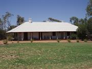
5 Brook St York
REGISTERED AS PART OF 3019
Residency (fmr) Nursing Quarters
York
Avon Arc
Constructed from 1843
| Type | Status | Date | Documents |
|---|---|---|---|
| Heritage List | Adopted | 25 Nov 2019 | |
| State Register | Registered | 09 Feb 1996 | HCWebsite.Listing+ListingDocument, HCWebsite.Listing+ListingDocument |
| Type | Status | Date | Documents |
|---|---|---|---|
| (no listings) |
| Type | Status | Date | Grading/Management | |
|---|---|---|---|---|
| Category | ||||
| Classified by the National Trust | Classified | |||
| Register of the National Estate | Permanent | 21 Mar 1978 | ||
| Local Heritage Survey | Adopted | 25 Nov 2019 | Grade A | |
03019 York Hospital Heritage Precinct
| Library Id | Title | Medium | Year Of Publication |
|---|---|---|---|
| 5626 | Residency Museum York : conservation works (final report). | Conservation works report | 2002 |
| 12029 | Final report: York Residency Musem. Conservation | 1985 | |
| 6426 | A preliminary study of convict sites in Western Australia (draft). | Heritage Study {Other} | 1997 |
| 7461 | York sketchbook. | Book | 2003 |
| 5423 | Residency Museum Brook Street, York : conservation plan. | Heritage Study {Cons'n Plan} | 2001 |
Individual Building or Group
| Epoch | General | Specific |
|---|---|---|
| Other Use | HEALTH | Housing or Quarters |
| Present Use | EDUCATIONAL | Museum |
| Original Use | RESIDENTIAL | Single storey residence |
| Other Use | HEALTH | Hospital |
| Style |
|---|
| Victorian Georgian |
| Type | General | Specific |
|---|---|---|
| Wall | BRICK | Painted Brick |
| Roof | METAL | Corrugated Iron |
| General | Specific |
|---|---|
| DEMOGRAPHIC SETTLEMENT & MOBILITY | Settlements |
| DEMOGRAPHIC SETTLEMENT & MOBILITY | Government policy |
| PEOPLE | Early settlers |
| DEMOGRAPHIC SETTLEMENT & MOBILITY | Workers {incl. Aboriginal, convict} |
This information is provided voluntarily as a public service. The information provided is made available in good faith and is derived from sources believed to be reliable and accurate. However, the information is provided solely on the basis that readers will be responsible for making their own assessment of the matters discussed herein and are advised to verify all relevant representations, statements and information.
Constructed from 1843
The Residency building/s are in good condition and open to the public, as a representative of a former administration and legal system. The Residency Museum forms the last remaining components of what was the convict depot, a precinct of Government buildings that played an integral role in the development of York. Residency Museum was opened on 27 August 1972. It was the first regional museum established under the Museum Act 1969-73, to be recognised by the Western Australian Museum.
Residency Museum is a single-storey brick and iron structure that is sited on the same Reserve as the Old York Hospital.
Integrity: Good Authenticity: Good
Good
| Ref ID No | Ref Name | Ref Source | Ref Date |
|---|---|---|---|
| 'York Historical Survey' National Estate Study. | |||
| A preliminary study of convict sites – Western Australia Heritage Study in Western Australia (draft). | |||
| Residency Museum, Brook Street, York – Western Australia Heritage Study Conservation Plan. | |||
| Western Australia Heritage Study – Conservation Works |
| Owner | Category |
|---|---|
| Shire of York | Local Gov't |
This information is provided voluntarily as a public service. The information provided is made available in good faith and is derived from sources believed to be reliable and accurate. However, the information is provided solely on the basis that readers will be responsible for making their own assessment of the matters discussed herein and are advised to verify all relevant representations, statements and information.
4 Broome St York
Part of Central York Heritage Area P26586
York
Avon Arc
| Type | Status | Date | Documents |
|---|---|---|---|
| (no listings) |
| Type | Status | Date | Documents |
|---|---|---|---|
| (no listings) |
| Type | Status | Date | Grading/Management | |
|---|---|---|---|---|
| Category | ||||
| Local Heritage Survey | Adopted | 25 Nov 2019 | Considerable Significance | |
Individual Building or Group
| Epoch | General | Specific |
|---|---|---|
| Original Use | HEALTH | Hospital |
| Present Use | RESIDENTIAL | Single storey residence |
| Style |
|---|
| Federation Bungalow |
| Federation Queen Anne |
| Type | General | Specific |
|---|---|---|
| Roof | METAL | Other Metal |
| Wall | BRICK | Face Brick |
This information is provided voluntarily as a public service. The information provided is made available in good faith and is derived from sources believed to be reliable and accurate. However, the information is provided solely on the basis that readers will be responsible for making their own assessment of the matters discussed herein and are advised to verify all relevant representations, statements and information.

Constructed from 1895
26586 Central York Heritage Area
Stratford House Maternity Hospital (fmr) is a significant example of a fine residence of the late 1890s evidencing influences of the Federation Queen Anne architectural style, and demonstrating a period of development and ways of life associated with maternity and private hospitals that are no longer practiced. It makes a considerable aesthetic contribution to the historic townscape of York.
The single storey face brick residence has a prominent front gable and two depths of setbacks with a bullnose veranda around those setbacks. The veranda has decorative brackets to the timber posts. The main entry sidelights and a fanlight are central on the 3 face frontage. The front gables are detailed in half-timber on roughcast. The prominent front gable is over a projected rectangular bay that has central double-hung sash window with side lights. Tall face brick chimneys with moulded detailing dominate the roof-scape.
In 1895, Stratford House has a recorded birth, indicating it was a maternity hospital. In 1906, it was reported that Mt Charles Chifney died in his residence (Stratford House). In 1910, a schoolteacher resided there, next door to the doctor on the corner of Avon Terrace. In 1915, the property operated as a Maternity Hospital, advertised as being run by Nurse Newington, located next to the Doctor. In 1916, Nurse Easther advertised the same.
Moderate/high
Good
This information is provided voluntarily as a public service. The information provided is made available in good faith and is derived from sources believed to be reliable and accurate. However, the information is provided solely on the basis that readers will be responsible for making their own assessment of the matters discussed herein and are advised to verify all relevant representations, statements and information.
Burgess Siding Rd off Northam Rd York
Burgess Siding
York
Avon Arc
| Type | Status | Date | Documents |
|---|---|---|---|
| (no listings) |
| Type | Status | Date | Documents |
|---|---|---|---|
| (no listings) |
| Type | Status | Date | Grading/Management | |
|---|---|---|---|---|
| Category | ||||
| Local Heritage Survey | Adopted | 25 Nov 2019 | Grade C | |
Landscape
| Epoch | General | Specific |
|---|---|---|
| Original Use | Transport\Communications | Rail: Other |
| Present Use | Transport\Communications | Rail: Other |
This information is provided voluntarily as a public service. The information provided is made available in good faith and is derived from sources believed to be reliable and accurate. However, the information is provided solely on the basis that readers will be responsible for making their own assessment of the matters discussed herein and are advised to verify all relevant representations, statements and information.
Constructed from 1885
Burges Siding is associated with the railway extension from York through Spencer’s Brook junction to Perth and Northam. Burges Siding was one of several sidings between York and Spencer’s Brook providing access to local farmers for the sending and receiving of their goods and supplies. Burges Siding represents historic associations with Burges’ Tipperary Farm.
No evidence on site.
The Avon Valley developed in the 1830s as a pastoral region, with the town of York, on the Avon River, established in 1835. A lack of good roads was a major problem for the transport of produce. In 1881, following the opening of the Eastern Railway from Fremantle to Guildford, the railway was extended to Chidlow and onto Northam and York via Spencers Brook. In 1885, part of Avon Locations X and Y on the south side of South Street and owned by John Henry Monger, were subdivided. Location Y was traversed by the railway line, then under construction, and the York station was located in the new subdivision. Edward Keane was the contractor for the railway line. In 1960 the Government contracted with BHP Co Ltd for an iron and steel works in Kwinana contingent on a standard railway between Kalgoorlie and Kwinana via Cannington, transporting iron ore from Koolyanobbing, culminating in the transcontinental standard gauge railway. The rail followed a route through Northam and Toodyay, carrying all the state’s produce, and York subsequently resorted to local traffic on the original track. York Railway Station was rendered almost redundant. York Railway Station officially closed to traffic on18 April 1987.
Ruins
This information is provided voluntarily as a public service. The information provided is made available in good faith and is derived from sources believed to be reliable and accurate. However, the information is provided solely on the basis that readers will be responsible for making their own assessment of the matters discussed herein and are advised to verify all relevant representations, statements and information.
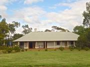
15 Carter Rd York
Lot 10 Carter Rd
Hope Farm
York
Avon Arc
| Type | Status | Date | Documents |
|---|---|---|---|
| Heritage List | Adopted | 25 Nov 2019 |
| Type | Status | Date | Documents |
|---|---|---|---|
| (no listings) |
| Type | Status | Date | Grading/Management | |
|---|---|---|---|---|
| Category | ||||
| Local Heritage Survey | Adopted | 25 Nov 2019 | Grade B | |
Good as at Aug 2007
Individual Building or Group
| Epoch | General | Specific |
|---|---|---|
| Present Use | RESIDENTIAL | Other |
This information is provided voluntarily as a public service. The information provided is made available in good faith and is derived from sources believed to be reliable and accurate. However, the information is provided solely on the basis that readers will be responsible for making their own assessment of the matters discussed herein and are advised to verify all relevant representations, statements and information.

Constructed from 1880
Hope Farm represents a significant landholding with buildings that demonstrate a way of life and the evolution of the property on the outskirts of York town, spanning several periods of development. The close association with Dr Hope, a prominent citizen in the State and in York, is of considerable significance. Hope Farm makes a considerable contribution to the historic aesthetic of York.
The site comprises several buildings relatively close to the street frontage, with the entry signalled pencil pines flanking the main gate. A two-storey residence dominates the group. The two-storey building is symmetrical with surrounding bullnose verandas at both levels. The main roof is a high-pitched gambrel hipped roof. The support timbers are square with criss-cross balustrades to the ground and first floor verandas. A separate residence at right angles has a high-pitched pavilion gable roof with a break pitch front veranda with balustrade details as for the two-storey residence.
James William Hope was born in Wales (1851-1918). In 1874, he gained his medical degree in Edinburgh and was offered the District Medical Officer position in York, and came to the colony, taking the position in 1875 (-1882). He invested in agricultural and pastoral enterprises and later was involved in gold prospecting. In 1878 he married Helena Aurora Monger, J.H. Monger’s daughter (6 children), and at that time was made Captain of the York Rifles. In 1881, he was appointed a Justice of the Peace. In 1882, he equipped an exploration party to Southern Cross that discovered Hope’s Hill Mine that was later purchased by an English syndicate, with Dr Hope retaining an interest. In 1882, he was Medical Officer at Fremantle Public Hospital (including Medical Officer to Fremantle Prison and Rottnest Island Convict Establishment). In 1892, he was commissioned as Captain of the Artillery Corps in Fremantle, and promoted to Major in 1897. In 1909 he was appointed to the inaugural position of Commissioner of Public Health for WA, serving until 1915. Originally a 200 acre property, it was gifted to Dr Hope.
Integrity: High Authenticity: Moderate
Good
This information is provided voluntarily as a public service. The information provided is made available in good faith and is derived from sources believed to be reliable and accurate. However, the information is provided solely on the basis that readers will be responsible for making their own assessment of the matters discussed herein and are advised to verify all relevant representations, statements and information.
87 Centennial Dr York
Previously recorded as 71 Pool St
House, 71 Pool Street
York
Avon Arc
| Type | Status | Date | Documents |
|---|---|---|---|
| Heritage List | Adopted | 25 Nov 2019 |
| Type | Status | Date | Documents |
|---|---|---|---|
| (no listings) |
| Type | Status | Date | Grading/Management | |
|---|---|---|---|---|
| Category | ||||
| Local Heritage Survey | Adopted | 25 Nov 2019 | Grade B | |
Individual Building or Group
| Epoch | General | Specific |
|---|---|---|
| Present Use | RESIDENTIAL | Single storey residence |
| Original Use | RESIDENTIAL | Single storey residence |
This information is provided voluntarily as a public service. The information provided is made available in good faith and is derived from sources believed to be reliable and accurate. However, the information is provided solely on the basis that readers will be responsible for making their own assessment of the matters discussed herein and are advised to verify all relevant representations, statements and information.

Constructed from 1890, Constructed from 1862
Residence, 87 Centennial Avenue, likely a Federation bungalow with an original c.1863 mudbrick building on the site, is a fine example of the early Federation period, and evidences associations with Ticket of Leave men, and, Jane Boyd who operated Miss Boyd’s School c.1871-1879, at this property. Those associations represent ways of life no longer practiced. The place makes a significant contribution to the history and historical townscape of York.
The residence is located at the top of a rise, sloping away on one side and to the rear. It is close to the front boundary that is delineated with a low spaced picket fence. The single storey face stone residence has a hipped roof. A bullnose veranda runs the entire perimeter of the residence with enclosures to the rear. The veranda is supported by square timber posts and criss-cross timber balustrades. The symmetrical frontage evidences a face brick wall in Garden Wall bond (Colonial bond) when there are 3 or 4 courses of stretchers to one course of headers. The front shows a central front door set with fanlight and sidelights, flanked by single double-hung windows. Tall face brick chimneys with stucco moulded corbelled detail are evident, one with a curious coned hood.
Land purchased by Dr McCoy c.1862. A dwelling was possibly built by Ticket of Leave men. In 1869 Andrew & Elizabeth Boyd purchased the property. Their daughter Jane operated Miss Boyd’s School between 1871 to approximately 1879. Jane had been a government school mistress between 1879-1889. NOTE: The residence seems to be of the early Federation period, although the documentary evidence suggests a c.1863 build by Ticket of Leave men. It is possible that the original building is the mudbrick outbuilding (not viewed) that is also on the site. Further research would be worthwhile.
Integrity: High Authenticity: Moderate/high
Good
This information is provided voluntarily as a public service. The information provided is made available in good faith and is derived from sources believed to be reliable and accurate. However, the information is provided solely on the basis that readers will be responsible for making their own assessment of the matters discussed herein and are advised to verify all relevant representations, statements and information.
Central York York
Area bounded by Balladong St, Northam-York Railway line, Grey St, Ford St and Avon River
York
Avon Arc
| Type | Status | Date | Documents |
|---|---|---|---|
| Heritage Area | Adopted | 25 Nov 2019 |
| Type | Status | Date | Documents |
|---|---|---|---|
| (no listings) |
| Type | Status | Date | Grading/Management | |
|---|---|---|---|---|
| Category | ||||
| (no listings) | ||||
Individual Building or Group
This information is provided voluntarily as a public service. The information provided is made available in good faith and is derived from sources believed to be reliable and accurate. However, the information is provided solely on the basis that readers will be responsible for making their own assessment of the matters discussed herein and are advised to verify all relevant representations, statements and information.
• Central York Heritage Area represents the broad social and economic changes from the mid-nineteenth century in the remaining intact physical and cultural environment contributing to an understanding of the development of York. • The landmark buildings within the Central York Heritage Area demonstrate the optimism and of York with the exceptional York Town Hall, Imperia and Castle Hotels; the government infrastructure of the railway station and original primary school; the landmark York Mill, Mongers Trading Post, the convent, Catholic school, Catholic Church group; and, the Avon Terrace Centre ((Refer to York Town Centre HPA) make an outstanding contribution to the historic aesthetic of York. • The cumulative effect of the scale, massing, texture, materials, colour, and detail of individual buildings including residential, inform of the distinctive periods and architectural styles from early town establishment in the 1860’s and 1870’s, the boom period of the 1890’s Federation style, the twentieth century developments of the early 1900’s and the prosperous surge in the late 1930’s and later decades.
The Central York area developed north of Blandstown and west of the Avon River, with JH Monger being the prominent identity of what was referred to as Mongerstown. The Central York Heritage Area mainly comprises single storey residential and commercial buildings though the Avon terrace spine and on the north and west edges. The dominant town centre of Avon Terrace within the Central York Heritage Area comprises a number of substantial two storey commercial buildings that form a continuum of late 19th and early 20th buildings along both sides of Avon Terrace between Macartney and South Streets.
The townsite of York was gazetted in November 1830, and the first settlers moved into the area the following year. The first town allotments were sold in 1835. York was one of the earliest rural settlements and the first inland town of the colony and developed as the service and administrative centre for the Avon Valley. A convict depot was established for the town in 1851. It helped the local economy and provide labour for public works. In 1871, York was declared a municipality; the fourth largest town in the state, behind Perth, Fremantle and Albany.
This information is provided voluntarily as a public service. The information provided is made available in good faith and is derived from sources believed to be reliable and accurate. However, the information is provided solely on the basis that readers will be responsible for making their own assessment of the matters discussed herein and are advised to verify all relevant representations, statements and information.
53 Christie Rtt York
Southeast corner of Neville St - Part of Central York Heritage Area P26586
York
Avon Arc
| Type | Status | Date | Documents |
|---|---|---|---|
| (no listings) |
| Type | Status | Date | Documents |
|---|---|---|---|
| (no listings) |
| Type | Status | Date | Grading/Management | |
|---|---|---|---|---|
| Category | ||||
| (no listings) | ||||
Individual Building or Group
| Style |
|---|
| Federation Bungalow |
| Type | General | Specific |
|---|---|---|
| Roof | METAL | Corrugated Iron |
| Wall | BRICK | Face Brick |
This information is provided voluntarily as a public service. The information provided is made available in good faith and is derived from sources believed to be reliable and accurate. However, the information is provided solely on the basis that readers will be responsible for making their own assessment of the matters discussed herein and are advised to verify all relevant representations, statements and information.
11 Clifford St York
Cnr Seabrook St
York
Avon Arc
Constructed from 1895
| Type | Status | Date | Documents |
|---|---|---|---|
| (no listings) |
| Type | Status | Date | Documents |
|---|---|---|---|
| (no listings) |
| Type | Status | Date | Grading/Management | |
|---|---|---|---|---|
| Category | ||||
| Municipal Inventory | Adopted | 31 Dec 1995 | Category 3 | |
Individual Building or Group
| Epoch | General | Specific |
|---|---|---|
| Original Use | EDUCATIONAL | Combined School |
| Original Use | RESIDENTIAL | Single storey residence |
| Present Use | RESIDENTIAL | Single storey residence |
| Type | General | Specific |
|---|---|---|
| Roof | METAL | Corrugated Iron |
| Wall | BRICK | Common Brick |
| General | Specific |
|---|---|
| SOCIAL & CIVIC ACTIVITIES | Education & science |
This information is provided voluntarily as a public service. The information provided is made available in good faith and is derived from sources believed to be reliable and accurate. However, the information is provided solely on the basis that readers will be responsible for making their own assessment of the matters discussed herein and are advised to verify all relevant representations, statements and information.
Constructed from 1895
The historic value of this building was that it was used as the York Grammar School, which closed in 1895. On a social significance Frank Bennet who later became the first headmaster of Guildford Grammar School established it.
Large cottage with a large central room and an encircling verandah.
Integrity: High Authenticity: High
Fair
This information is provided voluntarily as a public service. The information provided is made available in good faith and is derived from sources believed to be reliable and accurate. However, the information is provided solely on the basis that readers will be responsible for making their own assessment of the matters discussed herein and are advised to verify all relevant representations, statements and information.
33 Clifford St York
Lot 33 Clifford St
York
Avon Arc
Constructed from 1910 to 1911
| Type | Status | Date | Documents |
|---|---|---|---|
| Heritage List | Adopted | 25 Nov 2019 |
| Type | Status | Date | Documents |
|---|---|---|---|
| (no listings) |
| Type | Status | Date | Grading/Management | |
|---|---|---|---|---|
| Category | ||||
| Municipal Inventory | Adopted | 22 Sep 2008 | Category 3 | |
Fair as at 2007
| Name | Type | Year From | Year To |
|---|---|---|---|
| Wright, Powell & Cameron | Architect | - | - |
Individual Building or Group
| Epoch | General | Specific |
|---|---|---|
| Present Use | RESIDENTIAL | Single storey residence |
This information is provided voluntarily as a public service. The information provided is made available in good faith and is derived from sources believed to be reliable and accurate. However, the information is provided solely on the basis that readers will be responsible for making their own assessment of the matters discussed herein and are advised to verify all relevant representations, statements and information.
Constructed from 1910, Constructed from 1911
Integrity: Fair Authenticity: Fair
Fair
This information is provided voluntarily as a public service. The information provided is made available in good faith and is derived from sources believed to be reliable and accurate. However, the information is provided solely on the basis that readers will be responsible for making their own assessment of the matters discussed herein and are advised to verify all relevant representations, statements and information.
34 Clifford St York
Lot 1, Clifford Street
S & RJ Cormack
York
Avon Arc
Constructed from 1900 to 1940
| Type | Status | Date | Documents |
|---|---|---|---|
| (no listings) |
| Type | Status | Date | Documents |
|---|---|---|---|
| (no listings) |
| Type | Status | Date | Grading/Management | |
|---|---|---|---|---|
| Category | ||||
| (no listings) | ||||
Good as at August 2007
Individual Building or Group
| Epoch | General | Specific |
|---|---|---|
| Present Use | RESIDENTIAL | Single storey residence |
This information is provided voluntarily as a public service. The information provided is made available in good faith and is derived from sources believed to be reliable and accurate. However, the information is provided solely on the basis that readers will be responsible for making their own assessment of the matters discussed herein and are advised to verify all relevant representations, statements and information.
Constructed from 1900, Constructed from 1940
Red brick residence with stone footings and rendered above dado/sill height. Verandah features timber posts and balustrade as well as rendered brickwork and columns. The roof is tiled with several gables and stucco chimneys and terracotta pots.
Removed from the Heritage Listed on 30 April 2019.
Integrity: Good Authenticity: Good
Good
This information is provided voluntarily as a public service. The information provided is made available in good faith and is derived from sources believed to be reliable and accurate. However, the information is provided solely on the basis that readers will be responsible for making their own assessment of the matters discussed herein and are advised to verify all relevant representations, statements and information.
9 Clifford St York
York
Avon Arc
Constructed from 1860
| Type | Status | Date | Documents |
|---|---|---|---|
| Heritage List | Adopted | 25 Nov 2019 |
| Type | Status | Date | Documents |
|---|---|---|---|
| (no listings) |
| Type | Status | Date | Grading/Management | |
|---|---|---|---|---|
| Category | ||||
| Municipal Inventory | Adopted | 31 Dec 1995 | Category 3 | |
Individual Building or Group
| Epoch | General | Specific |
|---|---|---|
| Present Use | RESIDENTIAL | Single storey residence |
| Original Use | RESIDENTIAL | Single storey residence |
| Type | General | Specific |
|---|---|---|
| Wall | BRICK | Common Brick |
| Roof | METAL | Corrugated Iron |
| General | Specific |
|---|---|
| OCCUPATIONS | Manufacturing & processing |
This information is provided voluntarily as a public service. The information provided is made available in good faith and is derived from sources believed to be reliable and accurate. However, the information is provided solely on the basis that readers will be responsible for making their own assessment of the matters discussed herein and are advised to verify all relevant representations, statements and information.
Constructed from 1860
The previous owners of the building, a Mr Henderson, developed a brickworks at the rear of the property. The dwelling is significant because it was one of the earliest houses built east of the river.
Painted Flemish bond brick cottage with a bull nose verandah.
Integrity: Moderate Authenticity: Moderate
Moderate
This information is provided voluntarily as a public service. The information provided is made available in good faith and is derived from sources believed to be reliable and accurate. However, the information is provided solely on the basis that readers will be responsible for making their own assessment of the matters discussed herein and are advised to verify all relevant representations, statements and information.
Cowan Rd York
also known as Craig's cottage
York
Avon Arc
Constructed from 1865
| Type | Status | Date | Documents |
|---|---|---|---|
| Heritage List | Adopted | 25 Nov 2019 |
| Type | Status | Date | Documents |
|---|---|---|---|
| (no listings) |
| Type | Status | Date | Grading/Management | |
|---|---|---|---|---|
| Category | ||||
| Local Heritage Survey | Adopted | 25 Nov 2019 | Grade B | |
Individual Building or Group
| Epoch | General | Specific |
|---|---|---|
| Present Use | VACANT\UNUSED | Vacant\Unused |
| Original Use | FARMING\PASTORAL | Homestead |
| Type | General | Specific |
|---|---|---|
| Roof | METAL | Corrugated Iron |
| Wall | STONE | Other Stone |
| General | Specific |
|---|---|
| OCCUPATIONS | Grazing, pastoralism & dairying |
This information is provided voluntarily as a public service. The information provided is made available in good faith and is derived from sources believed to be reliable and accurate. However, the information is provided solely on the basis that readers will be responsible for making their own assessment of the matters discussed herein and are advised to verify all relevant representations, statements and information.
Constructed from 1865
The historic value of what remains is that it is apart of the original York farmhouses. On a social value the last owner, Mr Gordon Marwick, is a well known local identity.
The ruins of the building remain. The remains are in close proximity to areas of new residential and subdivision development. The physical evidence indicated three stages of development. The original building was a two roomed rammed earth cottage. Two additional rooms and entry steps were added in stone at the river façade. The rammed earth wall has been extended in height. A lean-to extension has been added in brick at the rear.
The homestead site is close to Mile Pool and linked to land used as the Weslyan Native Mission: Gerald Mission. In 1851 Reverend John Smithies of the Weslyan Church, and his wife Hannah moved to York to open the Gerald Mission at Mile Pool. Within a few years the Mission failed and he left Western Australia in 1854. Walkinshaw Cowan, York’s Resident Magistrate, owned for some period until 1868. Richard Gallop (1843-1899) arrived in York in 1865, associated with one of the earliest families in the Colony; his father Richard snr became a respected pioneer of market gardening in Perth. Richard Gallop managed the Albion Inn in Blandstown for 3 years before purchasing Mile Pool Farm from Walkinshaw Cowan, York’s Resident Magistrate, in 1868. He developed that property into one of the best fruit growing properties in York prior to broad-acre agriculture and established the potential future industry for the York district. He was one of five inaugural members of the York Municipal Council in 1871, and elected to the Road Board that same year, and served both for ten years including other voluntary service around the town. He sold in 1888 due to ill health and moved to 208 Avon Terrace with his wife.
Poor
| Ref ID No | Ref Name | Ref Source | Ref Date |
|---|---|---|---|
| Heritage Council’s Website | Heritage Council of WA |
This information is provided voluntarily as a public service. The information provided is made available in good faith and is derived from sources believed to be reliable and accurate. However, the information is provided solely on the basis that readers will be responsible for making their own assessment of the matters discussed herein and are advised to verify all relevant representations, statements and information.
16 Dinsdale St York
Lot 18 Dinsdale Street
Sunny Hill
York
Avon Arc
Constructed from 1900
| Type | Status | Date | Documents |
|---|---|---|---|
| Heritage List | Adopted | 25 Nov 2019 |
| Type | Status | Date | Documents |
|---|---|---|---|
| (no listings) |
| Type | Status | Date | Grading/Management | |
|---|---|---|---|---|
| Category | ||||
| Municipal Inventory | Adopted | 22 Sep 2008 | Category 3 | |
Good as at Aug 2007.
Individual Building or Group
| Epoch | General | Specific |
|---|---|---|
| Present Use | RESIDENTIAL | Single storey residence |
This information is provided voluntarily as a public service. The information provided is made available in good faith and is derived from sources believed to be reliable and accurate. However, the information is provided solely on the basis that readers will be responsible for making their own assessment of the matters discussed herein and are advised to verify all relevant representations, statements and information.
Constructed from 1900
Brick or stone residence with corrugat6ed iron hipped roof and wrap around verandah. Features quoins to openings and timber detail to verandah. Additions and alterations have been made to the house.
Integrity: Good Authenticity: Good
Good
This information is provided voluntarily as a public service. The information provided is made available in good faith and is derived from sources believed to be reliable and accurate. However, the information is provided solely on the basis that readers will be responsible for making their own assessment of the matters discussed herein and are advised to verify all relevant representations, statements and information.
3 Dinsdale St York
Lot 14 Dinsdale St
York
Avon Arc
Constructed from 1900
| Type | Status | Date | Documents |
|---|---|---|---|
| Heritage List | Adopted | 25 Nov 2019 |
| Type | Status | Date | Documents |
|---|---|---|---|
| (no listings) |
| Type | Status | Date | Grading/Management | |
|---|---|---|---|---|
| Category | ||||
| Municipal Inventory | Adopted | 22 Sep 2008 | Category 3 | |
Good as at Aug 2007
Individual Building or Group
| Epoch | General | Specific |
|---|---|---|
| Present Use | RESIDENTIAL | Single storey residence |
This information is provided voluntarily as a public service. The information provided is made available in good faith and is derived from sources believed to be reliable and accurate. However, the information is provided solely on the basis that readers will be responsible for making their own assessment of the matters discussed herein and are advised to verify all relevant representations, statements and information.
Constructed from 1900
Brick or stone residence with corrugat6ed iron hipped roof and wrap around verandah. Features quoins to openings and timber detail to verandah.
Integrity: Good Authenticity: Good
Good
This information is provided voluntarily as a public service. The information provided is made available in good faith and is derived from sources believed to be reliable and accurate. However, the information is provided solely on the basis that readers will be responsible for making their own assessment of the matters discussed herein and are advised to verify all relevant representations, statements and information.
bounded by Ford & Dinsdale Sts & Ulster Rd York
York
Avon Arc
Constructed from 1843
| Type | Status | Date | Documents |
|---|---|---|---|
| (no listings) |
| Type | Status | Date | Documents |
|---|---|---|---|
| (no listings) |
| Type | Status | Date | Grading/Management | |
|---|---|---|---|---|
| Category | ||||
| Municipal Inventory | Adopted | 31 Dec 1995 | Category 4 | |
Urban Park
| Epoch | General | Specific |
|---|---|---|
| Original Use | PARK\RESERVE | Park\Reserve |
| Present Use | PARK\RESERVE | Park\Reserve |
| General | Specific |
|---|---|
| SOCIAL & CIVIC ACTIVITIES | Sport, recreation & entertainment |
This information is provided voluntarily as a public service. The information provided is made available in good faith and is derived from sources believed to be reliable and accurate. However, the information is provided solely on the basis that readers will be responsible for making their own assessment of the matters discussed herein and are advised to verify all relevant representations, statements and information.
Constructed from 1843
Historic significance is that this site was the first inland golf club. The reserve has been associated with sporting activities since Colonial times, which also gives it a social value.
The property is fenced and has trees dotted around. The property is used for the Pony Club and as such has jumps and a track used by the Club.
| Owner | Category |
|---|---|
| Shire of York | Local Gov't |
This information is provided voluntarily as a public service. The information provided is made available in good faith and is derived from sources believed to be reliable and accurate. However, the information is provided solely on the basis that readers will be responsible for making their own assessment of the matters discussed herein and are advised to verify all relevant representations, statements and information.
2 Ford St York
To be assessed as part of P2862 York Town Centre Precinct
York
Avon Arc
Constructed from 1870
| Type | Status | Date | Documents |
|---|---|---|---|
| Heritage List | Adopted | 25 Nov 2019 |
| Type | Status | Date | Documents |
|---|---|---|---|
| RHP - To be assessed | Current | 31 Oct 2003 |
| Type | Status | Date | Grading/Management | |
|---|---|---|---|---|
| Category | ||||
| Local Heritage Survey | Adopted | 25 Nov 2019 | Grade B | |
02862 York Town Centre Precinct
Individual Building or Group
| Epoch | General | Specific |
|---|---|---|
| Present Use | RESIDENTIAL | Single storey residence |
| Original Use | RESIDENTIAL | Single storey residence |
| Type | General | Specific |
|---|---|---|
| Roof | METAL | Corrugated Iron |
| Wall | BRICK | Common Brick |
| General | Specific |
|---|---|
| DEMOGRAPHIC SETTLEMENT & MOBILITY | Workers {incl. Aboriginal, convict} |
This information is provided voluntarily as a public service. The information provided is made available in good faith and is derived from sources believed to be reliable and accurate. However, the information is provided solely on the basis that readers will be responsible for making their own assessment of the matters discussed herein and are advised to verify all relevant representations, statements and information.

Constructed from 1850
Residence, 2 Ford Street, on the west bank of the Avon River on the northern edge of Mongerstown is significant in being one of the few remaining dwellings of the earliest phase of development in of York’s development. It is a good example of a Victorian Georgian dwelling that has been developed and retained in its original form and scale to make a significant contribution to the historical fabric and townscape of York.
The single storey modest scale rendered dwelling is low lying in close proximity on the west bank of the Avon River. The form evidences two periods of construction with likely the original at the west end (left) with a central entry flanked by single windows. The chimney central on the roof is likely associated with that original section of the cottage. The addition is seamless on the east side towards the river. The overall roof is a simple hipped roof with the perimeter veranda at break pitch.
After York was opened for selection in 1830, the first settlers, arrived in 1831 from the Swan River settlement with the task of establishing a Government Farm, although it was not a success and In 1832, Revett. H. Bland and Arthur Trimmer leased the farm (Balladong) for two sections: Trimmer to north, later sold to J Monger, in what later became Mongerstown, and Bland to the south in what became known as Blandstown. 2 Ford Street, on the west bank of the Avon River is on the north edge of Mongerstown and one of very few in that area that are of the early phase of York’s development. Ratebooks indicate that at one time H Screigh resided here. His occupation was woodcutter and charcoal burner.
Integrity: High Authenticity: Moderate/high
Fair/Good
This information is provided voluntarily as a public service. The information provided is made available in good faith and is derived from sources believed to be reliable and accurate. However, the information is provided solely on the basis that readers will be responsible for making their own assessment of the matters discussed herein and are advised to verify all relevant representations, statements and information.
22 Ford St York
Cnr Georgiana St
York
Avon Arc
| Type | Status | Date | Documents |
|---|---|---|---|
| Heritage List | Adopted | 25 Nov 2019 |
| Type | Status | Date | Documents |
|---|---|---|---|
| (no listings) |
| Type | Status | Date | Grading/Management | |
|---|---|---|---|---|
| Category | ||||
| Local Heritage Survey | Adopted | 25 Nov 2019 | Grade B | |
Individual Building or Group
| Epoch | General | Specific |
|---|---|---|
| Present Use | RESIDENTIAL | Single storey residence |
| Style |
|---|
| Federation Bungalow |
| Type | General | Specific |
|---|---|---|
| Roof | METAL | Corrugated Iron |
This information is provided voluntarily as a public service. The information provided is made available in good faith and is derived from sources believed to be reliable and accurate. However, the information is provided solely on the basis that readers will be responsible for making their own assessment of the matters discussed herein and are advised to verify all relevant representations, statements and information.

Constructed from 1895
Residence, 22 Ford Street is significant as fine intact example of a timber framed weatherboard Federation bungalow that demonstrates a prosperous period of development and contributes to the historic fabric and townscape of York town.
The single storey residence is set in landscape gardens behind a decorative low picket fence along the front boundary. It has a hipped roof with a protruding half-timbered on roughcast gable feature, with finial. A separate hipped skillion veranda extends along on both sides, around the gable front and the recessed front of the residence. The entry is delineated on the veranda roof with a small gable with a finial. The gable front features a double hung window flanked by vertical narrow sidelights. The face brick chimneys have corbelled tops.
Integrity: High Authenticity: Moderate/high
Good
This information is provided voluntarily as a public service. The information provided is made available in good faith and is derived from sources believed to be reliable and accurate. However, the information is provided solely on the basis that readers will be responsible for making their own assessment of the matters discussed herein and are advised to verify all relevant representations, statements and information.
26 Ford St York
Northeast corner of Alfred St
York
Avon Arc
| Type | Status | Date | Documents |
|---|---|---|---|
| Heritage List | Adopted | 25 Nov 2019 |
| Type | Status | Date | Documents |
|---|---|---|---|
| (no listings) |
| Type | Status | Date | Grading/Management | |
|---|---|---|---|---|
| Category | ||||
| Local Heritage Survey | Adopted | 25 Nov 2019 | Grade B | |
Individual Building or Group
| Epoch | General | Specific |
|---|---|---|
| Present Use | RESIDENTIAL | Single storey residence |
| Style |
|---|
| Federation Bungalow |
| Type | General | Specific |
|---|---|---|
| Wall | BRICK | Face Brick |
| Roof | METAL | Corrugated Iron |
This information is provided voluntarily as a public service. The information provided is made available in good faith and is derived from sources believed to be reliable and accurate. However, the information is provided solely on the basis that readers will be responsible for making their own assessment of the matters discussed herein and are advised to verify all relevant representations, statements and information.

Constructed from 1910
Residence, 26 Ford Street is significant as good intact example of a typical Federation bungalow that represents the middle class residences of that period of development and contributes to the historic townscape of York.
across the symmetrical frontage, supported by stop-chamfered square timber posts and decorative timber brackets. The face brick walls have a rendered band at window-sill level with decorative detailing beneath each of the sills of the single double-hung sash windows that flanks the central front door. The front door set comprises side panels and glazing and a fanlight above. A tall rendered corbelled chimney dominates the roof line.
Integrity: High Authenticity: Moderate/high
Good
This information is provided voluntarily as a public service. The information provided is made available in good faith and is derived from sources believed to be reliable and accurate. However, the information is provided solely on the basis that readers will be responsible for making their own assessment of the matters discussed herein and are advised to verify all relevant representations, statements and information.
28 Ford St York
Northwest Cnr Alfred St
York
Avon Arc
| Type | Status | Date | Documents |
|---|---|---|---|
| Heritage List | Adopted | 25 Nov 2019 |
| Type | Status | Date | Documents |
|---|---|---|---|
| (no listings) |
| Type | Status | Date | Grading/Management | |
|---|---|---|---|---|
| Category | ||||
| Local Heritage Survey | Adopted | 25 Nov 2019 | Grade B | |
Individual Building or Group
| Epoch | General | Specific |
|---|---|---|
| Present Use | RESIDENTIAL | Single storey residence |
| Style |
|---|
| Federation Bungalow |
| Type | General | Specific |
|---|---|---|
| Wall | BRICK | Face Brick |
| Roof | METAL | Corrugated Iron |
This information is provided voluntarily as a public service. The information provided is made available in good faith and is derived from sources believed to be reliable and accurate. However, the information is provided solely on the basis that readers will be responsible for making their own assessment of the matters discussed herein and are advised to verify all relevant representations, statements and information.

Constructed from 1912
Residence, 28 Ford Street is significant as fine intact example of a Federation bungalow that demonstrates a prosperous period of development and contributes to the historic townscape of York.
The single storey residence is in an elevated position with a significant slope down the Alfred Street frontage where an expansive half-timber roughcast gable dominates the elevation. The bullnose veranda extends across that frontage, with a criss-cross timber balustrade, returning along the rear (also with balustrade) and across the main frontage of Ford Street, ending at the protruding gable feature on that frontage. The face brick walls have a rendered band at window-sill level. The Alfred Street frontage is symmetrical with two pairs of spaced double-hung sash windows while the Ford street frontage has a “Bachelor” double hung window on the front entry wall and return gable wall. The front entry set comprises sidelight panels and a fanlight above the door. A tall face brick chimney with rendered corbel dominates the roof line. A timber framed gabled arbour delineates the property entry on Ford Street.
Integrity: High Authenticity: Moderate/high
Fair/good
This information is provided voluntarily as a public service. The information provided is made available in good faith and is derived from sources believed to be reliable and accurate. However, the information is provided solely on the basis that readers will be responsible for making their own assessment of the matters discussed herein and are advised to verify all relevant representations, statements and information.
32 Ford St York
York
Avon Arc
| Type | Status | Date | Documents |
|---|---|---|---|
| Heritage List | Adopted | 25 Nov 2019 |
| Type | Status | Date | Documents |
|---|---|---|---|
| (no listings) |
| Type | Status | Date | Grading/Management | |
|---|---|---|---|---|
| Category | ||||
| Local Heritage Survey | Adopted | 25 Nov 2019 | Grade B | |
Individual Building or Group
| Epoch | General | Specific |
|---|---|---|
| Present Use | RESIDENTIAL | Single storey residence |
| Style |
|---|
| Federation Bungalow |
| Type | General | Specific |
|---|---|---|
| Roof | METAL | Corrugated Iron |
| Wall | BRICK | Face Brick |
This information is provided voluntarily as a public service. The information provided is made available in good faith and is derived from sources believed to be reliable and accurate. However, the information is provided solely on the basis that readers will be responsible for making their own assessment of the matters discussed herein and are advised to verify all relevant representations, statements and information.

Constructed from 1904
Residence, 32 Ford Street is significant as fine intact example of a Federation bungalow that demonstrates a prosperous period of development and contributes to the historic townscape of York.
The single storey residence is set in landscape gardens behind a low picket fence along the front boundary. It has a hipped roof with a half-timbered on a truncated front corner and a gable on the side elevation. A separate bullnose veranda extends across the front and down the sides. The veranda is supported by turned timber posts and decorative brackets. The rectangular face brick chimney has stucco corbelled top and is dominant on the front roof.
The land was subdivided in 1898 by O’Hooley and Monger. Charlotte (Lotty) Ashworth, was an early owner, Harris, a one-time Mayor with a drapery store in town also owned the property
Integrity: High Authenticity: Moderate/high
Good
This information is provided voluntarily as a public service. The information provided is made available in good faith and is derived from sources believed to be reliable and accurate. However, the information is provided solely on the basis that readers will be responsible for making their own assessment of the matters discussed herein and are advised to verify all relevant representations, statements and information.