Local Government
Vincent
Region
Metropolitan
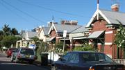
165-185 Lake St Perth
House numbers 165-167 (Ensenada & Coronada), 169-173, 175-179, 181-185
Ensenada
Vincent
Metropolitan
Constructed from 1903
| Type | Status | Date | Documents |
|---|---|---|---|
| Heritage List | Adopted |
| Type | Status | Date | Documents |
|---|---|---|---|
| RHP - Does not warrant assessment | Current | 25 Nov 2011 |
| Type | Status | Date | Grading/Management | |
|---|---|---|---|---|
| Category | ||||
| Municipal Inventory | Adopted | 13 Nov 1995 | Category A | |
Individual Building or Group
| Epoch | General | Specific |
|---|---|---|
| Present Use | RESIDENTIAL | Conjoined residence |
| Present Use | RESIDENTIAL | Two storey residence |
| Present Use | RESIDENTIAL | Terrace housing |
| Original Use | RESIDENTIAL | Conjoined residence |
| Present Use | RESIDENTIAL | Single storey residence |
| Original Use | RESIDENTIAL | Terrace housing |
| Original Use | RESIDENTIAL | Single storey residence |
| Original Use | RESIDENTIAL | Two storey residence |
| Style |
|---|
| Federation Filigree |
| Federation Italianate |
| Type | General | Specific |
|---|---|---|
| Other | TIMBER | Other Timber |
| Wall | BRICK | Common Brick |
| Roof | METAL | Corrugated Iron |
| Wall | BRICK | Rendered Brick |
| General | Specific |
|---|---|
| DEMOGRAPHIC SETTLEMENT & MOBILITY | Settlements |
This information is provided voluntarily as a public service. The information provided is made available in good faith and is derived from sources believed to be reliable and accurate. However, the information is provided solely on the basis that readers will be responsible for making their own assessment of the matters discussed herein and are advised to verify all relevant representations, statements and information.
Constructed from 1903
The semi-detached pair (Ensenada & Coronada) at 165-167 are a fine and unusual example of a Federation Filigree terrace pair. It makes a significant contribution to the streetscape particularly with the considerable plantings in the front garden. It demonstrates changes in the social status of the area. The semi-detached pairs, 169-173, 175-179 & 181-185 Lake Street, are good and representative examples of the Federation Bungalow style that contribute to the streetscape and character of the area. The places have associations with the neighbouring Brooking Park Estate.
The pair of two storeyed houses (165-167) was built in 1902 opposite the similarly styled Baker's Terrace. The building has a parapet with balustrading and a pediment over each dwelling bearing the date and the names "Ensenada" and "Coronada" respectively. The three pairs of single storeyed semi-detached dwellings (169-173, 175-179 & 181-185) have a turned bullnose verandah supported by stop chamfered posts with timber brackets. The gables have finials and are half timbered with roughcast infill and a timber bracketed frieze. A small gablet has a timber ventilator inset. Each has a brick chimney with a corbelled stucco trim. The casement windows have square lights above. The places are setback from the street, behind fences, but are mostly obscured by dense and inappropriate tree plantings. Extensions at the rear of Coronado- also top storey alterations and roof intrusions.
The residences at Nos. 165-167 Lake Street were built in 1902, and were given the names of 'Ensenada' and 'Coronada'. They were built on the Brooking Park Estate which was developed in 1896. The estate was named for surveyor J. S. Brooking, whose home 'Lakeside' at No. 106 Palmerston Street was on part of the Estate. The Estate included Suburban Lot 1, on the corner of Lake and Brisbane Streets, on which an orange orchard and associated residence were situated. (Nearby Orange Avenue was so named because of this.) This orchard was planted by early settler, Richard Gallop, who was granted four acres in 1885 on land between Palmerston and Lake streets. Gallop who arrived in Western Australia in 1829 as an indentured labourer, also grew vegetables on the site. In the estate subdivision, the orange orchard and residence were sited on Lots 9-17 on Lake Street, between Stuart and Hope streets, and were offered for sale as one parcel. The existing residence, on Lot 17 (shown on hte 1897 'City of Perth & Suburbs Sewerage Plans', 1897), then No. 239 was shown in the Wise's Post Office Directories as being occupied by Frederick Sandeman in 1901. It was later numbered 163 Lake Street. Four semi-detached pairs and one detached dwelling (Nos. 165-187 Lake Street) were built on the remainder of the site, replacing the orange orchard. In 1902, the land was owned by William Henry Vincent and was recorded as vacant. By 1904, there were six residences completed: two numbered 227-229 (Nos. 165-167) and four numbered 231-241 (No. 169-179). No 243 (No. 181) was occupied by the contractor, Fred James Vincent (also referred to as James Fred) and the rest of the land was still vacant. William Henry Vincent came to WA from Victoria in 1899. He had worked in his father's building company in Victoria and the USA in the mid 1880s. In WA, the company, R. P. Vincent & Son, built the Supreme Court, extensions to Government House and Royal Perth Hospital. After his father's death, William Vincent also built the Horseshoe Bridge, and bought two brick companies. His other activities included terms as president of the Master Builder's Association, chairman of the Children's Hospital Board, Art Gallery Trustee, and member of the Weld Club. It is not known if the contractor, Fred James Vincent was a relative. The dwellings at Nos. 165-167 Lake Street, named Ensenada and Coronada, were originally occupied by a doctor and a retired person, and were valued at £47 each. They were the grandest of the four semi-detached residences in the group. Each have four bedrooms and a 10 metre long central hallway. In 1915, No. 165 was occupied by Mrs L. Allen and No. 167 by William Thomson and Charles Patterson. In 1932, both residences were listed as 'apartments', with No. 165 occupied by Mrs Rita Traynor and No. 167 by Mrs Milly Allen. The difference between apartments and a boarding house is not clear. It may have involved the provision, or not, of meals, but more likely 'apartments' was simply a more refined name for a boarding house. In the 1960s and 1970s, No. 165 was still operating as a boarding house and had become run down. In 1981, it was purchased as a private residence and restored. The work included the removal of parts of walls to open and brighten the interior. No. 167 was also purchased for restoration in 1981. The Chilean willows which largely block the view of the place were planted at this time by the owners to provide privacy to the lower floors while retaining the views from the balconies. Nos. 169-173, 175-179 & 181-185 are identical. When constructed they were valued at £39. No. 169-173 were occupied by a contractor and manager in 1904. In 1915, they were occupied by Mrs A. King and Myer Sharp. No. 181-185 were occupied by Thomas Kane and Meyer Jacobs in that year. The semi-detached pair situated between these two semi pairs (Nos. 175-179) has a narrower street frontage. In 1949, the last year of the Directories, the residents of the subject places were; No. 165 Mrs Trayer - apartments. No. 167 T.M Lynch, No. 169 Mrs Dalliston, No. 173 Paul Rispoli, No. 175 Mrs G. McLachlan, No. 179 Luke Vodanovic, No. 181 Mrs Ruby Ashton and No. 185 Leonard Mitchell. Stuart Street Reserve on south-west corner at the intersection of Lake and Stuart streets, oppostie the southern boundary o the original subdivision, is part of the Wetlands Trail begun in 2001 to highlight the series of original wetlands within the Town of Vincent.
Mostly intact (165-167)Intact (169-173, 175-179 & 181-185)
This information is provided voluntarily as a public service. The information provided is made available in good faith and is derived from sources believed to be reliable and accurate. However, the information is provided solely on the basis that readers will be responsible for making their own assessment of the matters discussed herein and are advised to verify all relevant representations, statements and information.
169-173 Lake St Perth
Vincent
Metropolitan
Constructed from 1903
| Type | Status | Date | Documents |
|---|---|---|---|
| (no listings) |
| Type | Status | Date | Documents |
|---|---|---|---|
| (no listings) |
| Type | Status | Date | Grading/Management | |
|---|---|---|---|---|
| Category | ||||
| (no listings) | ||||
18024 Lake Street Orange Orchard Estate semi-detached
Individual Building or Group
| Epoch | General | Specific |
|---|---|---|
| Present Use | RESIDENTIAL | Conjoined residence |
| Original Use | RESIDENTIAL | Conjoined residence |
| Type | General | Specific |
|---|---|---|
| Wall | BRICK | Rendered Brick |
| Roof | METAL | Corrugated Iron |
| Wall | BRICK | Face Brick |
| General | Specific |
|---|---|
| DEMOGRAPHIC SETTLEMENT & MOBILITY | Settlements |
This information is provided voluntarily as a public service. The information provided is made available in good faith and is derived from sources believed to be reliable and accurate. However, the information is provided solely on the basis that readers will be responsible for making their own assessment of the matters discussed herein and are advised to verify all relevant representations, statements and information.
175-179 Lake St Perth
Vincent
Metropolitan
Constructed from 1903
| Type | Status | Date | Documents |
|---|---|---|---|
| (no listings) |
| Type | Status | Date | Documents |
|---|---|---|---|
| (no listings) |
| Type | Status | Date | Grading/Management | |
|---|---|---|---|---|
| Category | ||||
| (no listings) | ||||
18024 Lake Street Orange Orchard Estate semi-detached
Individual Building or Group
| Epoch | General | Specific |
|---|---|---|
| Present Use | RESIDENTIAL | Conjoined residence |
| Original Use | RESIDENTIAL | Conjoined residence |
| Type | General | Specific |
|---|---|---|
| Wall | BRICK | Face Brick |
| Roof | METAL | Corrugated Iron |
| Wall | BRICK | Rendered Brick |
| Other | TIMBER | Other Timber |
This information is provided voluntarily as a public service. The information provided is made available in good faith and is derived from sources believed to be reliable and accurate. However, the information is provided solely on the basis that readers will be responsible for making their own assessment of the matters discussed herein and are advised to verify all relevant representations, statements and information.
181-185 Lake St Perth
Vincent
Metropolitan
Constructed from 1903
| Type | Status | Date | Documents |
|---|---|---|---|
| (no listings) |
| Type | Status | Date | Documents |
|---|---|---|---|
| (no listings) |
| Type | Status | Date | Grading/Management | |
|---|---|---|---|---|
| Category | ||||
| (no listings) | ||||
18024 Lake Street Orange Orchard Estate semi-detached
Individual Building or Group
| Epoch | General | Specific |
|---|---|---|
| Present Use | RESIDENTIAL | Conjoined residence |
| Original Use | RESIDENTIAL | Conjoined residence |
| Type | General | Specific |
|---|---|---|
| Wall | BRICK | Rendered Brick |
| Roof | METAL | Corrugated Iron |
| Other | TIMBER | Other Timber |
| Wall | BRICK | Face Brick |
| General | Specific |
|---|---|
| DEMOGRAPHIC SETTLEMENT & MOBILITY | Settlements |
This information is provided voluntarily as a public service. The information provided is made available in good faith and is derived from sources believed to be reliable and accurate. However, the information is provided solely on the basis that readers will be responsible for making their own assessment of the matters discussed herein and are advised to verify all relevant representations, statements and information.
189 Lake St Perth
Vincent
Metropolitan
Constructed from 1908
| Type | Status | Date | Documents |
|---|---|---|---|
| Heritage List | Adopted |
| Type | Status | Date | Documents |
|---|---|---|---|
| (no listings) |
| Type | Status | Date | Grading/Management | |
|---|---|---|---|---|
| Category | ||||
| Municipal Inventory | Adopted | 12 Sep 2006 | Category B | |
Individual Building or Group
| Epoch | General | Specific |
|---|---|---|
| Original Use | Transport\Communications | Road: Other |
| Present Use | RESIDENTIAL | Conjoined residence |
| Original Use | RESIDENTIAL | Conjoined residence |
| Present Use | Transport\Communications | Road: Other |
| Style |
|---|
| Federation Free Classical |
| Type | General | Specific |
|---|---|---|
| Other | CONCRETE | Other Concrete |
| Wall | BRICK | Face Brick |
| Roof | METAL | Other Metal |
| Roof | TILE | Other Tile |
| Other | TIMBER | Other Timber |
| Other | METAL | Other Metal |
| General | Specific |
|---|---|
| OUTSIDE INFLUENCES | Depression & boom |
This information is provided voluntarily as a public service. The information provided is made available in good faith and is derived from sources believed to be reliable and accurate. However, the information is provided solely on the basis that readers will be responsible for making their own assessment of the matters discussed herein and are advised to verify all relevant representations, statements and information.
Constructed from 1908
Street sign: The extant old street signs are enamelled artefacts which demonstrate the variety of colourways and typefaces used in the suburb’s early street signage. Their significance is enhanced by remaining in location. Dwelling: The place has some aesthetic value as a good example of a Federation Free Classical style semi-detached duplex characterised by its simplicity, contrasting materials and texture, front parapet and symmetry contributing to the quality of its immediate setting. The semi-detached duplex at Nos. 189 - 191 Lake Street constructed c1908, together with the semi-detached duplex adjacent at Nos. 193 - 195 Lake Street constructed c1910 have some historic value as a complementary pair of Federation Free Classical style semi-detached duplexes that demonstrate the character and scale of semi-detached dwellings constructed on the city fringes as a response to the rapid population increase of the 1890’s Gold Boom and the early years of the 20th Century.
Street sign: Early street signs were enamelled metal, in various colourways and with a variety of type faces. The signs are artefacts of their period and gain significance by remaining in location. Early street signs also remain at 2 Dangan Street and 114 Bulwer Street. Semi-detached dwelling: The single storey semi-detached dwelling at No. 189 is a mirror pair to No. 191 constructed c1908 in the Federation Free Classical style of architecture. The face brick dwelling has a single room frontage and a gabled roof concealed behind a partially moulded polystyrene parapet with a polystyrene pediment above. The pediments are not original, believed to be constructed some time later to mimic the pediment on the semi-detached duplexes adjacent at Nos. 193 - 195 Lake Street, Perth. The parapet features a precast console bracket with a precast ball motif on top whihc is currenlty painted cream. Currently the dwelling at No. 189 Lake Street has a corrugated colourbond roof. A photograph of the dwelling taken in 1997 reveals it to have tile roofs at that time. Both dwellings feature two brick chimneys located on the southern and northern elevations of the dwellings respectively. A rendered brick and timber slat fence delineates No. 189 from the street with a brick paved court yards with some plantings behind the fence. The dwelling features a bullnose verandah being terracotta painted colourbond held up by turned timber posts separated by the party wall. A photograph taken of the dwelling in 1997 indicates that the bullnose verandahs were constructed after this time. The fenestration of the dwellings is simple and symmetrical with the front entrance positioned adjacent to the party wall featuring a set of two narrow window aluminium sliding windows with rendered decorative sills and skirts, addressing Lake Street. A rendered string course runs along the facade of the two dwelling, one at sill and one at above window height. Plans dated 27 February 1997 suggest that the internal layout of the two dwelling is indentical to that at No. 191 Lake Street, wiht a hallway extended along the party wall of the dwelling, featuring floorboards running in an east - west direction, high skirtings, moulded cornices and a ceiling rose. Two rooms project to the north of the hallway, with a fireplace located on the dividing wall in the front room. A timber panelled door leads from the end of the hallway into the lounge room area. The lounge room leads into the kitchen area with the kitchen facilities located on the southern wall and an additional room and a bathroom projecting to the north of the kitchen area. The subject dwelling is located along Lake Street on the corner of Hope Street. This section of Lake Street between Brisbane Street and Stuart Street slopes southwards and is characterised by single storey Federation dwellings, two storey Federation terrace housing, including 'Baker's Terrace' and Late Colonial style dwellings, together with some commercial properties. Alterations and addtions to the rear and modifications to the facade.
Street sign: Modern street signs are attached to metal poles and previously tall timber poles made from strong south-west timbers were used. Such poles were erected specifically for the purpose. Early street signs were attached to the side of the residence which occupied the street corner site. Remaining signs attached to residences are also located at 2 Dangan Street and 114 Bulwer Street. Semi-detached dwelling: The discovery of gold in Western Australia in the 1880's and the subsequent Gold Boom of the 1890's saw Perth's population increase four fold from 9,500 in 1891 to 44,000 in 1901 and 87,000 in 1911. A shortage of space in the city led to people moving out of the central area and creating tent '˜suburbs' and a demand for rental accommodation close to the city heightened. Continuing demand for housing led to several new subdivisions. Amongst there new subdivisions was 'Central Park Estate' was developed in 1892 at Lake Thompson and houses were erected along William, Newcastle, Lindsay and Money Streets and several shops along Newcastle and William Streets. Others also carried out in the area included that undertaken by the Colonial Finance Corporation between Brookman, Moir and Lake Streets and Forbes Road, the subdivisions 'Westralia' in 1895, 'Norwood' in 1896 and the 'Brooking Park Estate' also in 1896. The block that the subject dwelling and street sign erected, No. 189 Lake Street were part of the latter subdivision. During these Gold Boom years of the 1890's this area of Perth was substantially redeveloped with existing lots being further subdivided for housing and commercial development. A survey of the Wise Post Office Directories indicates that there was a range of commercial and residential properties that developed along Lake Street from the 1890's onwards between Newcastle Street and Brisbane Street. Some commercial properties on the western side of the street included the West Australian Boot Manufacturing Company (No. 117), the Newcastle Club Hotel located on the corner of Newcastle Street and a grocery store on the corner of Church Street, amongst single and semi-detached residential dwellings. The commercial properties are still in extant today, however many have since been converted to alternative uses including residential grouped dwellings, a backpackers and an office respectively. Other commercial developments in the area included The Northbridge Hotel, formerly the Royal Standard Hotel that was constructed circa 1897 on the corner of Brisbane Street, coinciding with the development of the residential estates in Brookman, Moir and Lake Street, initiated by the Colonial Finance Company. This mix of commercial and residential development was characteristic of this area of Perth and created a diversity of residents including shop keepers and trades people and home occupations such as dress makers and music teachers, together with professionals and the 'managerial class'. This diversity within the social fabric was demonstrated through the diversity in housing type. For instance the Colonial Finance Corporation, a typical property investment company, became the sole proprietor of part of Suburban Lot 28 with the intention of building a housing estate, within the area bounded by Lake Street to the west, Cicely Street (later known as Robinson Avenue) to the north, Wellman Avenue to the east and by Forbes Road to the south. The City of Perth rate books indicate that the subject place was owned by Fergus Arundal of Fremantle in 1898 and taht he also owned Nos. 187, 191 and 193. The 1908 Wise's Post Office Directories indicate that the resident was Mrs Isobel Holmes. There were five houses in her street block at that time and the occupations were listed for some of the residents. At No. 193 there was a businessman and No. 203 was a tailor and on the opposite corner at No. 187 there was a builder. In 1925 the resident at the subjcet place was Albert W Langford and Arthur J Langford was next door at No. 191. In 1949, the last year of the Directories, the resident was Jackson Kingsley. Today (2008) there are three dwellings within the strata subdivision namely the subject dwellings at No. 189 (Lot 2) and No. 191 (Lot 1) and the new dwellings at the rear of these two, at No. 2A (Lot 3) Hope Street, Perth.
High
This information is provided voluntarily as a public service. The information provided is made available in good faith and is derived from sources believed to be reliable and accurate. However, the information is provided solely on the basis that readers will be responsible for making their own assessment of the matters discussed herein and are advised to verify all relevant representations, statements and information.
193-195 Lake St Perth
Menai
Vincent
Metropolitan
Constructed from 1908
| Type | Status | Date | Documents |
|---|---|---|---|
| Heritage List | Adopted |
| Type | Status | Date | Documents |
|---|---|---|---|
| (no listings) |
| Type | Status | Date | Grading/Management | |
|---|---|---|---|---|
| Category | ||||
| Municipal Inventory | Adopted | 21 Nov 2006 | Category B | |
Individual Building or Group
| Epoch | General | Specific |
|---|---|---|
| Original Use | RESIDENTIAL | Conjoined residence |
| Present Use | RESIDENTIAL | Conjoined residence |
| Style |
|---|
| Federation Free Classical |
| Type | General | Specific |
|---|---|---|
| Wall | BRICK | Face Brick |
| Roof | TILE | Aluminium Tile |
| Wall | BRICK | Rendered Brick |
| Roof | METAL | Corrugated Iron |
This information is provided voluntarily as a public service. The information provided is made available in good faith and is derived from sources believed to be reliable and accurate. However, the information is provided solely on the basis that readers will be responsible for making their own assessment of the matters discussed herein and are advised to verify all relevant representations, statements and information.
Constructed from 1908
The single storey duplex at Nos. 193 - 195 Lake Street constructed in the Federation Free Classical Style are a good example of their type and form part of the Brooking Park Estate, named after well known surveyor and developer J S Brooking, an active participant in the development of the suburb.
The single storey duplex pair at No. 193 - 195 Lake Street are a mirror image of each other both featuring a one room frontage. The duplex has a parapet that has been distinctively combined into one pediment, centrally located with the name 'Menai' embossed in the pediment below the decorative stucco detail in the apex. The duplex has a bullnose front verandah supported by turned timber posts. The tuckpointed brick walls have rendered banding at window sill and door head height. Low rendered and pillar and palisade wall. None apparent
The semi-detached duplex was built on the Brooking Park Estate which was developed in 1896. The estate was named after surveyor John S. Brooking, whose home 'Lakeside' was on part of the estate at 106 Palmerston Street (built in 1885). That same year Richard Gallop was granted four acres of land on Palmerston/Lake Street where he grew vegetables and planted an orange grove. The Brooking Estate included suburban Lot 1, on the corner of Lake and Brisbane Streets. Lots 6 and 7 were part of this suburban lot north of Hope Street. In 1908 Wise's Post Office Directories show that Paul Reichardt of Reichardt and Co. was in No. 193 and No. 195 was occupied by Murdoch A. MacLennan. The City of Perth rate books show that the following year the owner of both residences was M.F. Roberts and the residents were Miss Fogarty (No. 193) and Howard J. Ebans at No. 195. In 1915 the Directories show James V. Gracey at No. 193 and John Tomlinson at No. 195 Lake Street. In the same street block at No. 203 was James Thompson, a medical practitioner. Other occupations listed in the street at that time were a constable, fuel dealer, contractor, grocer and cab proprietor and the Newcastle Club Hotel was on the corner of Newcastle and Lake streets. It is interesting to note that a 'pillar box' was also listed on the corner of Brisbane and Lake streets. In 1930 the residents were Percival Keeling at No. 193 and Joseph Bordas and George Korsunski at No. 195. The latter was listed as a scrap iron merchant. The doctor's surgery was still at No. 203 with Dr Harry S. Lucraft running his practice there and by that time Balcatta Lime Kilns, lime and stone merchants were operating at No. 197. In 1949 Mrs Ellen Keeling was at No. 193 and Robert Gertzel at No. 195. George Korsunski was then at No. 197 (listed as a metal merchant) as were Balcatta Lime Kilns. The Georgeff Brothers, Carl and N.H. (both medical practioners) were practising at No. 203.
High Degree
This information is provided voluntarily as a public service. The information provided is made available in good faith and is derived from sources believed to be reliable and accurate. However, the information is provided solely on the basis that readers will be responsible for making their own assessment of the matters discussed herein and are advised to verify all relevant representations, statements and information.
210 Lake St Perth
in MI as 196-198 Brisbane Street, Northbridge
Northbridge Hotel
Vincent
Metropolitan
Constructed from 1897 to 1996
| Type | Status | Date | Documents |
|---|---|---|---|
| Heritage List | Adopted |
| Type | Status | Date | Documents |
|---|---|---|---|
| RHP - Does not warrant assessment | Current | 28 Nov 2003 |
| Type | Status | Date | Grading/Management | |
|---|---|---|---|---|
| Category | ||||
| Statewide Hotel Survey | Completed | 01 Nov 1997 | ||
| Municipal Inventory | Adopted | 13 Nov 1995 | Category B | |
Individual Building or Group
| Epoch | General | Specific |
|---|---|---|
| Present Use | COMMERCIAL | Hotel, Tavern or Inn |
| Original Use | COMMERCIAL | Hotel, Tavern or Inn |
| Style |
|---|
| Federation Queen Anne |
| Type | General | Specific |
|---|---|---|
| Wall | BRICK | Rendered Brick |
| Roof | METAL | Corrugated Iron |
| General | Specific |
|---|---|
| OCCUPATIONS | Commercial & service industries |
This information is provided voluntarily as a public service. The information provided is made available in good faith and is derived from sources believed to be reliable and accurate. However, the information is provided solely on the basis that readers will be responsible for making their own assessment of the matters discussed herein and are advised to verify all relevant representations, statements and information.
Constructed from 1897
Hotel Northbridge (former Royal Standard Hotel) is a pattern book plain Queen Anne style hotel of the period. There were numerous comparable examples in suburban and provincial locations. It dates from the period of hotel building in the suburb, which coincided with the early Gold Boom and the suburban developments north of Perth, such as the nearby Brookman/Moir precinct. The hotel has provided continuous hospitality services since its establishment and its pattern of ownership and operation has reflected that of suburban hotels.
The two storey brick rendered building wraps the corner and features two gables on the Brisbane Street frontage. It has retained the original form but has had substantial modifications to its façade. Recent renovations (1996) removed many original openings and replicated the original two storey verandah. Zero setback to both streets and truncated corner. Façade treatment, reinstated verandah, interior layout.
Hotel Northbridge was originally known as the Royal Standard Hotel. The property appears on the 1897 PWD sewerage plans and is listed in the 1898 City of Perth rate books. It was situated on Perth Town Lot N88, on the corner of Lake, Brisbane and Amy streets. The Hotel Northbridge was established at the same time as the Colonial Finance Company's residential estate on Brookman, Moir and Lake streets. The general area was undergoing rapid residential and commercial development in the late 1890s. The place was under the ownership of Frederick Lee, a grocer, in 1898. (He is listed as being on the corner of Lake and Brisbane Streets in the 1897 Wise's Post Office Directories but not in the 1898 or 1899 ones. In 1898 Charles Robinson was replaced as the publican by Robert A. Carmichael. The Directories for 1900 list storekeeper Samuel T. McKeown at the street address, indicating that there was at least one shop space as part of the hotel building at this time. The City of Perth rate books indicate that in 1909 the shop was owned by Francis Nellie Timpel and operated by Florence Craib. In 1915, hairdresser Jack Pope occupied the shop and Thomas Heale was the licensee of the hotel. The hotel was owned by the Swan Brewery Co. Ltd at this time. The verandahs of the hotel were removed at some time, possibly during the general upgrading of existing hotels that took place in the late 1920s and 1930s, when the removal of verandahs was seen as giving buildings a sleek, modern look. Alternatively, they may have been removed in the 1940s or '50s, when the City council required the replacement of verandahs with awnings, as verandah posts were considered a hazard with more motor vehicles on the roads. It is believed that some of the proceeds from WA's famous 'Golden Eagle' nugget (the largest recorded in WA) found at Larkinville by J.J. Larcombe and his son in January 1931, were used for the hotel and they may have been used to fund these changes. The verandahs were reinstated in 1999 by the current owner, in keeping with current trends of nostalgia for old buildings. The hotel purchased the right-of-way in 1992 and in 1993 permission was granted to use it as an outdoor eating area (an extension to an existing restaurant), closing at 9 pm. However, an application to change this area to a public bar drinking area in 2001 was refused. Other alterations were made to the building in 2005 to open up the interior to cater for modern entertainments needs. The bar was refurbished in 2005 and approval was given to the hotel's manager, Timothy Leech, for alfresco dining along the Lake and Brisbane street footpaths within a limited area after a successful three-month trial period. Following the period of redevelopment '“ a $7 million dollar upgrade - between 1995 and 2005, the Northbridge Hotel re-emerged as the Hotel Northbridge. In 2006 further changes were made to the bar areas which included a wine cellar and to the kitchen with the addition of a pizza oven. In 2008 this 'boutique' hotel had a four-star rating. The accommodation areas included 49 suites and three penthouse suites; there were three bars and a restaurant; and there was also a function room which could accommodate 180 guests and a boardroom which could be booked.
Moderate - externallyLow/moderate - internally
This information is provided voluntarily as a public service. The information provided is made available in good faith and is derived from sources believed to be reliable and accurate. However, the information is provided solely on the basis that readers will be responsible for making their own assessment of the matters discussed herein and are advised to verify all relevant representations, statements and information.

147 Lincoln St Perth
23/1/2012 Address includes: 11 & 13 Grant St, Perth; and 128 Bulwer St, Perth. VFL. MI Address features: 11 & 13 Grant Street and omits 'original State School and the infants school' Comprises: Senior School, fmr Infants; School, fmr Teachers quarters, Shelter Shed, fmr Manual Training Room & pavilion Classroom
Vincent
Metropolitan
Constructed from 1895 to 1948
| Type | Status | Date | Documents |
|---|---|---|---|
| Heritage List | Adopted | ||
| State Register | Registered | 20 Apr 2004 | HCWebsite.Listing+ListingDocument, HCWebsite.Listing+ListingDocument |
| Type | Status | Date | Documents |
|---|---|---|---|
| (no listings) |
| Type | Status | Date | Grading/Management | |
|---|---|---|---|---|
| Category | ||||
| Municipal Inventory | Adopted | 13 Nov 1995 | Category A | |
| Name | Type | Year From | Year To |
|---|---|---|---|
| George T. Poole | Architect | - | - |
| Library Id | Title | Medium | Year Of Publication |
|---|---|---|---|
| 7158 | Highgate Primary School : alterations & additions : photographic record. | Archival Record | 2004 |
| 3646 | Highgate Primary School Shelter Shed and Toilet Block | Heritage Study {Other} | 1998 |
| 5539 | Highgate Primary School : conservation plan (Volume 1) & (Volume 2 - Appendices). | Heritage Study {Cons'n Plan} | 2002 |
Individual Building or Group
| Epoch | General | Specific |
|---|---|---|
| Original Use | EDUCATIONAL | Housing or Quarters |
| Original Use | EDUCATIONAL | Primary School |
| Present Use | EDUCATIONAL | Primary School |
| Style |
|---|
| Federation Queen Anne |
| Federation Arts and Crafts |
| Type | General | Specific |
|---|---|---|
| Roof | METAL | Corrugated Iron |
| Wall | BRICK | Rendered Brick |
| Wall | STONE | Limestone |
| Wall | BRICK | Common Brick |
| General | Specific |
|---|---|
| SOCIAL & CIVIC ACTIVITIES | Education & science |
This information is provided voluntarily as a public service. The information provided is made available in good faith and is derived from sources believed to be reliable and accurate. However, the information is provided solely on the basis that readers will be responsible for making their own assessment of the matters discussed herein and are advised to verify all relevant representations, statements and information.
Constructed from 1895
Highgate Primary School is a relatively intact group of school buildings, which evolved during the two decades from 1895, and which demonstrate the models and standards of infant and primary school accommodation for the periods of its development. It has assocations with four Principal Architects. The growth of the school population mirrors thedevelopment of the area. The school’s population also mirrors the continuous multi cultural makeup of the local population and the school is noted for its contribution to multi cultural education. The school has been an integral part of its community for more than 105 years.
The single storey Primary School comprises the original Highgate Senior School facing Lincoln Street and the Infants School on Bulwer Street. They were built to standard evolving patterns for Government schools of the time. The Senior School has classrooms arranged in wings around an internal assembly space with a lantern roof. The building has high hipped roofs with gabled projections. The red face brick walls, set on limestone footings, are embellished with bands of stucco. The tall windows are multi-paned and on the southern façade are capped in decorative gables. The brick chimneys have corbelled stucco trim. The Infants School has classrooms arranged around an internal assembly space with highlight windows. The building has hipped and gabled roofs. The red face brick walls, set partly on limestone footings, are embellished with bands of stucco. The Staff Quarters was a modest residence arranged around a central passage, providing accommodation of the standard of the time. Whilst keeping its original external appearance and much of its internal spaces and elements, the former Staff Quarters has been converted to Infant schooling and is proposed to be converted to staff facilities. The site also contains a former temporary classroom, a manual arts training room and a shelter shed, from the Interwar years which are now comparatively rare elements. Recent facilities are a transportable classroom and a new Assembly Space with associated canteen and toilets. The grounds are tidy, but worn, and contain elements left from the temporary structures erected during the Interwar period. Mostly setback from streets with gardens and plantings around the perimeter. Various modifications and extensions over the years to facilitate continuous function.
Highgate Hill was an early subdivision north of Newcastle Street that was developed by surveyor Charles Crossland in 1874, and named for his birthplace in London. Highgate Hill Primary School was one of the State's earliest suburban primary schools and appears on the c1897 PWD sewerage plans. Ten parents living in the immediate vicinity with 25 children between them ranging in age from four to eleven signed a formal application for a school. The Chief Government Architect at the time was George Temple Poole, and a single room was constructed initially on School Reserve No. 3269. When it was discovered that there would be a lot more children enrolling, a second room was erected. The first classes were held in the new two-room school buildings on 1 November 1895 and, as it turned out, 80 children were enrolled. The head teacher was Athol McGregor who remained at the school until 1926. He also instigated the inaugural meeting of the Public School's Association, which was held at the school in 1896. This associated was short-lived but he later became involved in teh State School Teachers' Union of WA and was awarded a life membership. A week after the school opened, Mr McGregor received an assistant, Anni Mitchell, and a monitor, Frederica Mitchell. Joshua Hamill joined the staff in January 1896. Teacher's quarters (designed by a private architect) were constructed in 1898 at a cost of 1000 pounds and a large extension and re-arrangement of classes was carried out between 1897 and 1899 at a cost of 1,400. Athol McGregor occupied the teachers quarters until his retirement at the end of 1926. He was followed by A.M Cooke who, although he retired in 1935, remained in residence until his death in 1947. The new building for the Highgate Infant's School (which had previously operated in a circus tent) was opened on 22 January 19000, to cater for the large amount of pupils at the school (340). The buildings were constructed to a standard plan of the time and accomodated 100 children. The head teacher occupied the house next door at No. 145 Lincoln Street. There were further additions to the Primary School in 1901 and 1903 (to accomodate another 50 children) plus a new room in the Infant's school for another 50. Further changes in 1905 - 06 added room for another 50 to both the Primary and Infant's schools. In 1909 - 10 extensive additions were carried out on the Infant's school at a cost of 870 pounds. Further additions in 1910 and 1912, a new classroom in 1913 and a manual training shed for woodwork and sewing followed in 1913 - 14. As the number of enrolments grew, pavilion classrooms were added in the school ground. These were timber framed rectangular buildings, clad in asbestos with an iron roof. They each comprised a classroom and a small storeroom. A shelter shed was also erected c.1948. A number of these buildings are shown on the 1953 MWSSDD sewerage plan. Declining numbers in the post World War II period saw soem of the classrooms being occupied by pupils from Girdlestone High School in 1952 and in 1955 the Primary and Infants' school's jubilee year, there was a total enrolment of nearly 700 students. A school library was also built in 1952 and it was officially opened on 22 June that year by the Hon. Lady Gairdner, wife of Sir Charles Gairdner, the state's lonber serving Governor. The school grounds wre divided into boys' and girls' playgrounds, with the ablution block on the shared boundary. There were ongoing problems for drainage in the grounds which were only finally resolved with underground and surface drainage in 1952. For many years the grounds were ably looked after by the school's gardner, Frank Wardell-Johnson, whom they shared with the North Perth Primary School. Frank lived with his parents Dr and Mrs Wardell-Johnson at No. 418 Beaufort Street, Highgate and later in Vincent Street, North Perth opposite Hyde Park. In 1970, the year the school celebrated 75 years of operation, it had 24 staff members. In a publication commemorating that anniversary Headmaster, George Spisbah, wrote that: 'The increasing international complexity of the student population became more and more evident in the transition period since 1964. At first Grekk and Italian pupils dominated the school scene in 1964, 1965 and 1966, to be followed by large groups of young people from Burma in 1967 and 1968 and finally in 1969, 1970 ever growing numbers of children from Yugoslavia. ' The school had always had a mixture of ethnic groups. many of the Jewish children, who lived in the area of Brisbane Street synagogue in early times had attended the school and in more recent times it has experienced waves Vietnamese children and those from China and other Asian countries and from the Middle East. In 1999 there were 54 different nationalities attending the school and in 2002 it was reported that the Chinese and Vietnamese communities were using the school at weekends for language classes for children to continue to learn their hereditary language as well as English. A covered assembly area was erected in 1997/98 and in 2002 additional classrooms were designed by Oldfield Knot Pty Ltd for an Early Childhood Education Program. In 2004 a new toilet block (replacing the 50 year -old toilets) and a covered walkway were designed, again by Oldfield Knott Pty Ltd. The subject place was entered as a permanent Entry in the Register of Heritage Places in 2004. In 2007 permission was granted for a new library to be erected. That year the Principal was Cris Sandi and the total number of students was 450. At that time the school has 22 teaching areas; 11 normal -sized classrooms, seven IEC classrooms (15 0 16 students per class), a music room, art room and two pre-primary rooms. Highgate Hill school always had a mixture of ethnic groups. Many of the Jewish children, who lived in the area of the Brisbane Street synagogue attended the school. The school grounds were divided into boys' and girls' playgrounds, with the ablution block on the shared boundary. A big shed provided the classroom for woodwork and sewing. As the number of enrolments grew, pavilion classrooms were added in the school ground. These were timber framed rectangular buildings, clad in asbestos with an iron roof. They each comprised a classroom and a small storeroom. A number of them are shown on the 1953 MWSSDD sewerage plan.
Intact
| Name | Type | Year From | Year To |
|---|---|---|---|
| George Temple Poole | Architect | - | - |
This information is provided voluntarily as a public service. The information provided is made available in good faith and is derived from sources believed to be reliable and accurate. However, the information is provided solely on the basis that readers will be responsible for making their own assessment of the matters discussed herein and are advised to verify all relevant representations, statements and information.

57 Lincoln St Perth
Additional address: 12 Smith Street, Perth
Highgate Police Station, Lockup & Quarters
Vincent
Metropolitan
Constructed from 1916, Constructed from 1897
| Type | Status | Date | Documents |
|---|---|---|---|
| Heritage List | Adopted | ||
| State Register | Registered | 12 May 2000 | HCWebsite.Listing+ListingDocument, HCWebsite.Listing+ListingDocument |
| Type | Status | Date | Documents |
|---|---|---|---|
| (no listings) |
| Type | Status | Date | Grading/Management | |
|---|---|---|---|---|
| Category | ||||
| Municipal Inventory | Adopted | 13 Nov 1995 | Category A | |
| Classified by the National Trust | Classified | 11 Sep 2000 | ||
| Name | Type | Year From | Year To |
|---|---|---|---|
| Robert J Haddon | Architect | - | - |
| Hillson Beasley | Architect | - | - |
| William B Hardwick | Architect | - | - |
| Library Id | Title | Medium | Year Of Publication |
|---|---|---|---|
| 4330 | Heritage Assessment of WA Police Services Property Highgate Concerning the Lincoln Street Ventilating Stack Former Police Station and Lockup | Heritage Study {Other} | 1998 |
| 4474 | Highgate Hill Police Station (FMR), Lincoln Street, Highgate: Conservation Plan | Heritage Study {Cons'n Plan} | 1999 |
| 4329 | 57 Lincoln Street Highgate-Former Police Station and Quarters (the Highgate Hill Police Station): Submission to the Heritage Council of Western Australia for Inclusion of the Highgate Police Station on the Register of Heritage Places | Report | 1998 |
Individual Building or Group
| Epoch | General | Specific |
|---|---|---|
| Present Use | GOVERNMENTAL | Gaol |
| Original Use | GOVERNMENTAL | Gaol |
| Present Use | GOVERNMENTAL | Police Station or Quarters |
| Original Use | GOVERNMENTAL | Police Station or Quarters |
| Style |
|---|
| Federation Bungalow |
| Type | General | Specific |
|---|---|---|
| Wall | BRICK | Common Brick |
| Roof | METAL | Corrugated Iron |
| General | Specific |
|---|---|
| PEOPLE | Famous & infamous people |
| TRANSPORT & COMMUNICATIONS | Telecommunications |
| DEMOGRAPHIC SETTLEMENT & MOBILITY | Government policy |
| SOCIAL & CIVIC ACTIVITIES | Law & order |
| DEMOGRAPHIC SETTLEMENT & MOBILITY | Settlements |
This information is provided voluntarily as a public service. The information provided is made available in good faith and is derived from sources believed to be reliable and accurate. However, the information is provided solely on the basis that readers will be responsible for making their own assessment of the matters discussed herein and are advised to verify all relevant representations, statements and information.
Constructed from 1897 to 1906
Highgate Hill Police Station (former) was an early suburban Police Station established in the early years of the district. The station continued to be used for community policing activities until the Second World War, when it became the centre for police wireless operations. Latterly it has been the home of the Road Safety Section and Bicycle Education unit of the WA Police Service. It has had continuous associations with the Police Department demonstrating changes in police operations.
The Station & Lockup and Police Quarters are single-storey brick and iron buildings. The Station was constructed in a standard bungalow style with verandahs on all sides and consisted of a charge room and two cells. The Quarters were built in a Federation Bungalow style with three bedrooms, a living room, kitchen and external bathroom. Additional structures have been added to link and extend the buildings. Considerable setback from Lincoln Street- hard surface. The quarters faces Smith Street and has a minimal setback more residential in nature. Addition of transmission room, carport and plant room to Quarters in 1969.
The place comprises a former Police Station and Lockup, constructed in 1897 by W. Young at a cost of £464-9-6 on Perth Lot 1088 (Crown Reserve 6245). Tenders were called on 26 March and awared on 7 May 1897 with completion scheduled for 7 August that year. The maintenance contract was awarded to W.C Mirfim and the station was officially opened on 1 November 1897. It consisted of a charge room and two lock-up cells. A water tank was situated originally on the south-east corner of the verandah and an earth closet (EC) and soak well on the property's north-east corner. In 1899 constable Michael Leen was in charge of the station. He remained until 1901. At this time a cow was kept in the fenced-off back half of the Police Station block. The suburban police station dates from the initial development phase of Highgate Hill. It is shown on the c1897 PWD sewerage plans. It is interesting to note that the plans for its construction were examined by Robert J. Haddon, W.B Hardwick and hillson Beasley, architects at PWD. Beasely was Chief Architect at PWD and responsible for a number of prominent buildings in the Vincent area and Haddon later became a notable architect and author in Melbourne, and Professor of Architecture at Melbourne University. The original plans included the police quarters but they were not erected until 1906. The builder was C.H Carter and the contractor and the contract price of 500 pounds. They consisted of a living room, three bedrooms, kithchen and outside bathroom and they were first occupied by the officer - in - charge, Corporal Patrick O'Halloran. He was still there in 1910 but by 1915 Sergeant John Kingston was in charge. The officer - in - charge of Highgate police station was allocated seven foot constables. In May 1898 two of these, McArthur and O'Conner were shot at while trying to apprehend a man with a rifle at the Brisbane Hotel in 1928. Mark's sucessor was Sergeant H. Jones. This shooting, which upset many of the local residents, also helped the Police Commissioner's lobby for the introduction of a firearms licensing system in WA. The first police constables in the Colony were appointed by Governor Stirling in 1829 but by 1850, only approximately 20 had been employed. A police force was established in 1851 in response to the arrival of convicts. In 1871 its number had grown to 146 and there were 36 police stations. A Police Act, passed in 1892 was amongst the early legislative acts passed after full self government was granted in Western Australia in 1890. Other police stations opened around the time of Highgate one were Claremont (1895), West Perth (1897), Fremantle (1897), North Fremantle (1897), Leederville (1898), Subiaco (1898), Beaconsfield (1898) and East Fremantle (1899). These were opened in response to the population grwoth - and suburban expansion - which was a result of the gold rushes. The Highgate Station was closed on 2 December 1940 following the opening of a new Inglewood Police Station. In late 1941 or early 1942, the central wireless section serving the police force was covertly moved from police headquarters into the Highgate Station and lock- up as a result of Japan's entry into World War II. Its call sign was VKI - Licence No. 1258. The location of the wireless section was kept secret at that time, as it was considered a prime bombing target. The wireless antennae was attached to the 38 metre tall sewer vent on the corner of the station block. A further response to Japan's entry in the War was the connection of all police stations to the system on 30 June 1942. It is possible that during this time the station was also used by the Commonwealth Department of Defence for communications purposes as it was not uncommon for Commonwealth Departments to use local police facilities. The police wireless service had been established in 1930 with its transmitter at Wireless Hill in Applecross until 1936 when it was moved to the Central Police Station. In 1949 the Highgate Station became the centre for vehicular communications which led to the formation of the Traffic Branch and Road Traffic Authority (RTA). In 1956 the wireless section was moved into the larger Police Quarters, and the building was extended to accommodate additional equipment and services. In June 1959, just three years after its location was disclosed, Police Commissioner J.M O'Brien reported: The Wireless Station in Lincoln Street, Highgate Hill, operates a 24 hours service; and in addition to the two way Morse system which enables the department to communicate direct with the headquarters of other Police Forces within the Commonwealth, it is now possible to send to and receive messages by radio telephony from all District Police Offices in the State, with the exception of Broome. The cars used for patrol duty in the Metropolitan area, the police launch, four vans and 37 other motor cars and utilities are also fitted with two way wireless sets while all police stations within the radius of the metropolitan area are now equipped with wireless and receiving sets. Constable (later Sergeant) S.C 'Jimmy' Austin was officer-in-charge of the wireless section from 1930 to 1966. The quarters were furthered enlarged in 1968 with the addition of a new plant room and a carport. In 1975, the final year of its operation at Highgate, VKI had radio connections with all the metropolitan police stations 338 vehicles and two launches plus links interstate and a country network of 39 base stations and 95 mobiles. In 1975 the Wireless Branch, known initially as the Radio Section and later again , the Communications Section, was transferred to Police Headquarters in East Perth. The Highgate Hill Police Station continued to be used by the WA Police Service, and was most recently occupied by the Road Safety Section and Bicycle Education unit. In 1999 the former Highgate Hill Police Station and lock - up and quarters were entered on the Register of Heritage Places on an Interim basis.
Mostly intact
| Name | Type | Year From | Year To |
|---|---|---|---|
| Public Works Department | Architect | - | - |
This information is provided voluntarily as a public service. The information provided is made available in good faith and is derived from sources believed to be reliable and accurate. However, the information is provided solely on the basis that readers will be responsible for making their own assessment of the matters discussed herein and are advised to verify all relevant representations, statements and information.

12 & 22 Lindsay St Perth
ALSO PART OF 11263 & 14590
Vincent
Metropolitan
Constructed from 1894
| Type | Status | Date | Documents |
|---|---|---|---|
| Heritage Agreement | YES | 26 Jun 2017 | HCWebsite.Listing+ListingDocument |
| State Register | Registered | 02 Jul 1999 | HCWebsite.Listing+ListingDocument, HCWebsite.Listing+ListingDocument |
| Type | Status | Date | Documents |
|---|---|---|---|
| (no listings) |
| Type | Status | Date | Grading/Management | |
|---|---|---|---|---|
| Category | ||||
| Perth Draft Inventory 99-01 | YES | 31 Dec 1999 | ||
| Classified by the National Trust | Classified | 11 Jun 2001 | ||
11263 Beaufort, Lindsay & Money Street Precinct
| Name | Type | Year From | Year To |
|---|---|---|---|
| K C Duncan & C J Stephens | Architect | - | - |
| Library Id | Title | Medium | Year Of Publication |
|---|---|---|---|
| 5876 | Ancillary structures, 12-18 Lindsay Street, Newcastle Street (Lindsay to Money St) : archival record. | Archival Record | 2002 |
| 6000 | Lindsay Street Flour Mill and Bakery Complex, Perth : conservation plan. | Heritage Study {Cons'n Plan} | 2002 |
| 7732 | The union bakery redevelopment: home of the East Perth Redevelopment Authority. | Brochure | 0 |
| 5874 | Ancillary structures, 219-223 Newcastle Street (Lake to William St) : archival record. | Archival Record | 2002 |
| 8012 | Heritage planning and management seminar 2006. | Loose-leaf | 2006 |
| 7251 | Northbridge Heritage Trail : 1. Aberdeen Street heritage precinct, 2. Lindsay & Money Streets heritage preinct, 3. Parry Street heritage precinct. | Brochure | 2004 |
Individual Building or Group
| Epoch | General | Specific |
|---|---|---|
| Original Use | COMMERCIAL | Shop\Retail Store {single} |
| Original Use | RESIDENTIAL | Single storey residence |
| Present Use | COMMERCIAL | Office or Administration Bldg |
| Original Use | INDUSTRIAL\MANUFACTURING | Flour Mill |
| Style |
|---|
| Federation Bungalow |
| Federation Free Classical |
| Federation Warehouse |
| Type | General | Specific |
|---|---|---|
| Wall | BRICK | Rendered Brick |
| Roof | METAL | Corrugated Iron |
| General | Specific |
|---|---|
| OCCUPATIONS | Manufacturing & processing |
| OCCUPATIONS | Commercial & service industries |
This information is provided voluntarily as a public service. The information provided is made available in good faith and is derived from sources believed to be reliable and accurate. However, the information is provided solely on the basis that readers will be responsible for making their own assessment of the matters discussed herein and are advised to verify all relevant representations, statements and information.

15-17 Lindsay St Perth
ALSO PART OF 11263 & 14590 Moved from City of Perth to Town of Vincent Change gazetted 29/5/07
Vincent
Metropolitan
Constructed from 1913
| Type | Status | Date | Documents |
|---|---|---|---|
| Heritage List | Adopted | ||
| State Register | Registered | 04 Nov 2005 | HCWebsite.Listing+ListingDocument, HCWebsite.Listing+ListingDocument |
| Type | Status | Date | Documents |
|---|---|---|---|
| (no listings) |
| Type | Status | Date | Grading/Management | |
|---|---|---|---|---|
| Category | ||||
| Municipal Inventory | Adopted | 13 Nov 2005 | Category A | |
11263 Beaufort, Lindsay & Money Street Precinct
The place is in fair to good condition. There is evidence of deterioration to some of the external brickwork and ground floor timber joinery.
| Library Id | Title | Medium | Year Of Publication |
|---|---|---|---|
| 6003 | Stables (fmr) 17 Lindsay Street, Perth : conservation plan. | Other | 2002 |
Individual Building or Group
| Epoch | General | Specific |
|---|---|---|
| Present Use | COMMERCIAL | Other |
| Original Use | FARMING\PASTORAL | Stable |
| Style |
|---|
| Victorian Georgian |
| Type | General | Specific |
|---|---|---|
| Roof | METAL | Corrugated Iron |
| Wall | BRICK | Common Brick |
| General | Specific |
|---|---|
| TRANSPORT & COMMUNICATIONS | Road transport |
| OCCUPATIONS | Manufacturing & processing |
| OCCUPATIONS | Commercial & service industries |
This information is provided voluntarily as a public service. The information provided is made available in good faith and is derived from sources believed to be reliable and accurate. However, the information is provided solely on the basis that readers will be responsible for making their own assessment of the matters discussed herein and are advised to verify all relevant representations, statements and information.
Constructed from 1913
The stables (former) are a fine intact example of Federation Functionalism. There are very few remaining examples of early twentieth century stables in metropolitan Perth. It was first used as stables for the Union Bakery in the later Interwar years. Following its resumption it has been used for a number of warehouse and manufacturing purposes. It demonstrates activities no longer practiced.
Simple large brick structure with gable roof attached on one side to another commercial building. Set back from the street, it has large double doors on the ground floor, with a smaller door directly above it and a hoist overhead for delivering heavy items directly into the upper level. The apex of the gable end contains a vent. The building is set well back from the street with a grassed area providing almost a residential character. Juliette balcony, new doors, internal fitouts
The bed of Lake Thomson, where Lindsay Street is situated, was used for farming and market gardening until the 1880s, when parcels of the land were sold off. One section of the land, comprising Money, Lindsay and Monger Streets and Robinson Avenue was subdivided by B.H. (Harry) Anstey in 1892. Anstey had amalgamated seven separate blocks into a 9.1 hectare block for residential subdivision. Henry (Harry) Cassidy Moore or 'Frosty' Moore established the Union Bakery and Flour Mill at Nos. 12'“16 Lindsay Street in 1894, and lived next door with his family at Nos. 18'“20. In 1898 the rateable value of his Lindsay Street home was ₤200. He was listed for the first time in Wise's Post Office Directories in 1898 but as Harry O. Moore, baker, at Nos 10 and 12. It is interesting to note that a W.G. Moore is also listed in a boarding house at No. 8 at that time. In 1901 he was listed as operating at Nos 20-22 and it was not until 1902 that the numbers were listed as 18-20 for the first time. From 1913 he is listed as owning Nos 12-16 as well but No. 17, the stables, was not listed until 1922 although they appear in the City of Perth rate books in 1913. Moore arrived in Western Australia in 1892 at the age of 21 and set up as a baker first in Hay Street, Perth. His wife looked after the shop and he did all the baking and the deliveries. He had trained as a baker in Ireland and purchased land in Lindsay Street for the purpose of erecting a house and bakery. He moved to Lindsay Street in 1895. No. 17 (Lot 123) was purchased in his wife's name, Sophia Moore, from Edward G. Joyce in 1909. The stables were erected in 1913 because expansion of the bakery meant that there was no longer sufficient space at the bakery site (Nos 10-12). Union Bakery bread was sold door to door from horse drawn carts around suburbs such as North Perth, East Perth, Mount Lawley, Subiaco and South Perth. The bakery was extended into a substantial three'“storey building which spread over the available land with the alterations and additions taking place in 1904, 1906-07 and just before World War I. His holdings then consisted of a three-storey bakery, shop, flour mill and an office (Nos 12-16). In 1910, a vacant piece of land on the opposite side of the street was purchased, and in 1913, new stables were built there for the horses which drew the bakery carts. James Brebber had designed and built a new house for the Moore family in 1891, and in 1913, had designed additions to the house (Nos 18-20). It is possible that he also designed and perhaps built the stables. Brebber also lived in Lindsay Street '“ at No. 26 ('Lyndock') and operated his business from No. 28. By 1941, the Union Bakery (H.C. Moore & Co.) had grown to one of the largest bakeries in Perth. It had its own flour mill that operated under the name of Aero Flour Co Ltd and they also made semolina and custard powder. During World War II they had Army contracts. At least one of the grandchildren, William (Bill) Moore, worked there in the bakehouse and then later delivering bread. Horses were used by the bakery until the 1950s when they were gradually phased out and vans purchased. There was one occasion when Henry bought horses at auction. '˜The next morning someone went down to feed them or to let them out and they had an addition. There was a foal there. By degrees they found out that all the horses he had bought were in foal and he had to buy some property (at Kenwick) to take them out of the city'. (Eleanor Jeffries) He also owned property at Lake Pinjar for the horses. After the delivery fleet was fully motorised the stables were used for storage. Following the death of Sophia in 1943, the title of No. 17 was transferred to Colonial Investment Pty Ltd, the Moore family company. The principal at that time was their son, William James Moore. In 1945 Henry married a neighbouring widow, Nora M. Graham and they moved to the family's beach house at North Beach. It was then occupied by William and his sister, Lillian. In 1959, Moore's milling business was sold to W. Thomas & Co., a large flour milling company. The flour mill in Lindsay Street was closed and the equipment removed but the bakery side continued to operate and even after the death of Henry in 1961 aged 90, it was run by two of his sons. Skippers Transport leased No. 17 from 1961 and established a vehicle repair and maintenance shop there until the 1970s. It was then taken over by Allwest Scientific Distributors (scientific glassware distributors). In 1980 the stables were purchased by the Metropolitan Region Planning Authority and again occupied by various tenants. From 1994 the place has been occupied as a workshop and studio/display area for a wrought iron furniture manufacturer. In June 2000 the title to the stables and Nos 12-20 was transferred to the East Perth Development Authority and it became part of EPRA's New Northbridge urban renewal project. It was entered on the Register of Heritage Places in December 2004.
This information is provided voluntarily as a public service. The information provided is made available in good faith and is derived from sources believed to be reliable and accurate. However, the information is provided solely on the basis that readers will be responsible for making their own assessment of the matters discussed herein and are advised to verify all relevant representations, statements and information.
54-60 Lindsay St Perth
Cnr Lindsey & Monger St initially considered as part of P17093; decision 24/3/05 NOT to include in P17093 group.
Vincent
Metropolitan
Constructed from 1980, Constructed from 1899
| Type | Status | Date | Documents |
|---|---|---|---|
| Heritage List | Adopted |
| Type | Status | Date | Documents |
|---|---|---|---|
| RHP - Assessed - Below Threshold | Current | 24 Mar 2005 |
| Type | Status | Date | Grading/Management | |
|---|---|---|---|---|
| Category | ||||
| Municipal Inventory | Adopted | 13 Nov 1995 | Category B | |
Generally Lindsay Street Terraces 54-60 have been well maintained, with painting the exterior brickwork, replacement of fence material and new front verandahs being the only maintenance and improvement regimes to have impacted on the exterior condition. The external condition of the remaining places seems fair, but the condition of the interiors has not been ascertained. Overall the place is in good condition.
Individual Building or Group
| Epoch | General | Specific |
|---|---|---|
| Present Use | RESIDENTIAL | Terrace housing |
| Original Use | RESIDENTIAL | Terrace housing |
| Style |
|---|
| Federation Filigree |
| Type | General | Specific |
|---|---|---|
| Wall | BRICK | Common Brick |
| Roof | METAL | Corrugated Iron |
| General | Specific |
|---|---|
| DEMOGRAPHIC SETTLEMENT & MOBILITY | Land allocation & subdivision |
| DEMOGRAPHIC SETTLEMENT & MOBILITY | Depression & boom |
| OCCUPATIONS | Domestic activities |
| OCCUPATIONS | Hospitality industry & tourism |
This information is provided voluntarily as a public service. The information provided is made available in good faith and is derived from sources believed to be reliable and accurate. However, the information is provided solely on the basis that readers will be responsible for making their own assessment of the matters discussed herein and are advised to verify all relevant representations, statements and information.
Constructed from 1899
The terraces at No. 54-60 Lindsay Street demonstrate the suitablility of this housing type to satisfy current housing needs a century after their construction. The size and scale of the group contribute to the streetscape.
Two storeyed row of four terrace houses. The roof heights step down to the south. There are verandahs at both levels. Balustrades are infilled with filigree, that appears to be a replacement for the original. The refurbishment of the 1980s, whilst sympathetic, adapted original finishes. The terraces, such as this one, within the Town of Vincent follow a pattern of single developer and leasing to tenants, whereas in the eastern states terraces were often developed co-operatively by a group of owners for their own occupation. Garden settings behind high brick pillared palisade or picket fencings. Extensive restoration in 1980s
The bed of Lake Thomson was used for farming and market gardening until the 1880s, when parcels of the land were sold off. A number of subdivisions were carried out in the early 1890s, and developed rapidly during the population boom of the gold rush period. The rear of the lots along the edge of the lake, on Newcastle, Brisbane and Beaufort streets, were also developed at this time, with the creation of Lindsay Street providing a street frontage for the rear of Lot N30 on Beaufort Street. The two-storey terrace houses at 54-60 Lindsay Street, on the corner of Monger Street, were one of the more substantial developments which took place there at this time. The row of four dwellings was built in 1899 and the capital value for No. 60 was given as ₤160 in the City of Perth rate books. The houses first appeared in Wise's Post Office Directories in 1900, numbered 44-50. At that time the residents were John Hogan, a police sub-inspector, Frank Exeter, Miss Mary Breed and James Campbell. The following year (1901) they were listed with different numbers '“ Nos 66-72. In 1904 Mrs Martha Hogan was living at No. 44 (No. 54) (perhaps a relative of the previously mentioned sub-inspector of police) and next door to her was a police sergeant. In 1917 the numbers were changed slightly to 56-62. That year three of the four were occupied by women. (This was during World War I when many of the menfolk were away fighting.) The next year, two of these had been let and only one remained vacant. In 1922 the numbers changed to those of today and the residents were William Silk (No. 54), Arthur Thomas (No. 56), William Whitworth (No.58) and John Inglis Logan (No. 60). In 1949, the last year of the Directories, the residents were Mrs Annie E. McKay (No. 54), James Marnham (No. 56), Francis L. Underwood (No. 58) and Anthony Saunter (No. 60). The terraces were extensively restored in the 1980s, as inner-city living began to make a return to popularity.
Moderate - 1980s adaptation has reduced intactness.
This information is provided voluntarily as a public service. The information provided is made available in good faith and is derived from sources believed to be reliable and accurate. However, the information is provided solely on the basis that readers will be responsible for making their own assessment of the matters discussed herein and are advised to verify all relevant representations, statements and information.
66 Lindsay St Perth
Vincent
Metropolitan
Constructed from 1880 to 1890
| Type | Status | Date | Documents |
|---|---|---|---|
| (no listings) |
| Type | Status | Date | Documents |
|---|---|---|---|
| (no listings) |
| Type | Status | Date | Grading/Management | |
|---|---|---|---|---|
| Category | ||||
| (no listings) | ||||
Individual Building or Group
| Epoch | General | Specific |
|---|---|---|
| Original Use | RESIDENTIAL | Single storey residence |
| Present Use | COMMERCIAL | Office or Administration Bldg |
| Type | General | Specific |
|---|---|---|
| Wall | BRICK | Common Brick |
| Roof | METAL | Corrugated Iron |
| General | Specific |
|---|---|
| DEMOGRAPHIC SETTLEMENT & MOBILITY | Settlements |
This information is provided voluntarily as a public service. The information provided is made available in good faith and is derived from sources believed to be reliable and accurate. However, the information is provided solely on the basis that readers will be responsible for making their own assessment of the matters discussed herein and are advised to verify all relevant representations, statements and information.
200-202 Lord St Perth
Moved from City of Perth to Town of Vincent Change gazetted 29/5/07
Vincent
Metropolitan
Constructed from 1900
| Type | Status | Date | Documents |
|---|---|---|---|
| (no listings) |
| Type | Status | Date | Documents |
|---|---|---|---|
| (no listings) |
| Type | Status | Date | Grading/Management | |
|---|---|---|---|---|
| Category | ||||
| Perth Draft Inventory 99-01 | YES | 31 Dec 1999 | ||
Individual Building or Group
| Epoch | General | Specific |
|---|---|---|
| Present Use | RESIDENTIAL | Conjoined residence |
| Original Use | RESIDENTIAL | Conjoined residence |
| Style |
|---|
| Federation Queen Anne |
| Type | General | Specific |
|---|---|---|
| Roof | METAL | Corrugated Iron |
| Wall | BRICK | Face Brick |
This information is provided voluntarily as a public service. The information provided is made available in good faith and is derived from sources believed to be reliable and accurate. However, the information is provided solely on the basis that readers will be responsible for making their own assessment of the matters discussed herein and are advised to verify all relevant representations, statements and information.
224-226 Lord St Perth
Moved from City of Perth to Town of Vincent Change gazetted 29/5/07
Vincent
Metropolitan
Constructed from 1900
| Type | Status | Date | Documents |
|---|---|---|---|
| (no listings) |
| Type | Status | Date | Documents |
|---|---|---|---|
| (no listings) |
| Type | Status | Date | Grading/Management | |
|---|---|---|---|---|
| Category | ||||
| Perth Draft Inventory 99-01 | YES | 31 Dec 1999 | ||
Individual Building or Group
| Epoch | General | Specific |
|---|---|---|
| Present Use | COMMERCIAL | Shop\Retail Store {single} |
| Original Use | COMMERCIAL | Shop\Retail Store {single} |
| Type | General | Specific |
|---|---|---|
| Wall | BRICK | Painted Brick |
| Roof | METAL | Corrugated Iron |
This information is provided voluntarily as a public service. The information provided is made available in good faith and is derived from sources believed to be reliable and accurate. However, the information is provided solely on the basis that readers will be responsible for making their own assessment of the matters discussed herein and are advised to verify all relevant representations, statements and information.
248-250 Lord St Perth
Cnr Coolgardie St Moved from City of Perth to Town of Vincent Change gazetted 29/5/07
Vincent
Metropolitan
| Type | Status | Date | Documents |
|---|---|---|---|
| (no listings) |
| Type | Status | Date | Documents |
|---|---|---|---|
| RHP - Does not warrant assessment | Current | 27 Oct 2006 |
| Type | Status | Date | Grading/Management | |
|---|---|---|---|---|
| Category | ||||
| (no listings) | ||||
Individual Building or Group
| Epoch | General | Specific |
|---|---|---|
| Original Use | RESIDENTIAL | Single storey residence |
This information is provided voluntarily as a public service. The information provided is made available in good faith and is derived from sources believed to be reliable and accurate. However, the information is provided solely on the basis that readers will be responsible for making their own assessment of the matters discussed herein and are advised to verify all relevant representations, statements and information.
Moir & Brookman Sts & Forbes Rd Perth
2-32 Brookman St (even numbers) 3-27 Moir St (odd numbers) 40 Forbes Rd 2-28 Moir St (even numbers) 1-31 Brookman St (odd numbers)
Vincent
Metropolitan
Constructed from 1897, Constructed from 1940
| Type | Status | Date | Documents |
|---|---|---|---|
| Heritage List | Adopted | ||
| State Register | Registered | 08 May 2007 | HCWebsite.Listing+ListingDocument, HCWebsite.Listing+ListingDocument |
| Type | Status | Date | Documents |
|---|---|---|---|
| (no listings) |
| Type | Status | Date | Grading/Management | |
|---|---|---|---|---|
| Category | ||||
| Register of the National Estate | Nominated | 23 Apr 1991 | ||
| Register of the National Estate | Indicative Place | |||
| Municipal Inventory | Adopted | 13 Nov 1995 | Category A | |
| Library Id | Title | Medium | Year Of Publication |
|---|---|---|---|
| 7430 | Brockman & Moir Streets design guidelines. | Brochure | 1995 |
| 9538 | 15 Moir Street, Perth: conservation works final report, June 2010. | Conservation works report | 2010 |
| 11664 | 27 Brookman Street, Perth | Conservation works report | 2017 |
| 9712 | Final report: Brookman and Moir Streets precinct, 21 Moir Street (Kempster residence). | Conservation works report | 2011 |
| 8873 | 17 Brookman Street Perth, conservation works. | Conservation works report | 2007 |
| 8993 | Brookman & Moir Street precinct. No 11 Moir Street, Perth. Conservation works 2007. | Conservation works report | 2008 |
| 9447 | 19 Brookman Street, Perth | Conservation works report | 2010 |
| 11663 | 18 Moir Street, Perth | Conservation works report | 2016 |
| 9509 | 21 Brookman Street, Perth: conservation works final report. | Conservation works report | 2010 |
| 8848 | 19 Brookman Street, Perth. | Conservation works report | 2007 |
| 9146 | Brookman and Moir Street precinct. No 17 Moir Street, Perth. Conservation works final progress report. | Conservation works report | 2008 |
| 8994 | Brookman and Moir Street development guidlines. | Heritage Study {Other} | 0 |
| 12000 | How can heritage values be protected in residential precincts undergoing gentrification? A case study of the Brookman and Moir Streets precinct. | Heritage Study {Other} | 2022 |
Precinct or Streetscape
| Epoch | General | Specific |
|---|---|---|
| Original Use | RESIDENTIAL | Single storey residence |
| Present Use | RESIDENTIAL | Conjoined residence |
| Original Use | RESIDENTIAL | Conjoined residence |
| Present Use | RESIDENTIAL | Single storey residence |
| Style |
|---|
| Federation Queen Anne |
| Type | General | Specific |
|---|---|---|
| Wall | STONE | Limestone |
| Roof | METAL | Corrugated Iron |
| Wall | BRICK | Common Brick |
| General | Specific |
|---|---|
| DEMOGRAPHIC SETTLEMENT & MOBILITY | Depression & boom |
| DEMOGRAPHIC SETTLEMENT & MOBILITY | Settlements |
| DEMOGRAPHIC SETTLEMENT & MOBILITY | Land allocation & subdivision |
This information is provided voluntarily as a public service. The information provided is made available in good faith and is derived from sources believed to be reliable and accurate. However, the information is provided solely on the basis that readers will be responsible for making their own assessment of the matters discussed herein and are advised to verify all relevant representations, statements and information.
Constructed from 1897
The Brookman and Moir Streets Group is a complete and intact residential development of 1897, undertaken by prominent citizens under William Brookman. The intact working class semi detached houses were constructed in the Federation Queen Anne Style. It demonstrates the social mores and way of life in the developing area north of Perth, at the commencement of the Gold Boom period. It provides a notable example of a late 19th century townscape with its repetitive building forms and development patterns. It is a unique example of a housing estate that includes. The scale of the subdivision and development by a speculative development company is a notable historic and social event of its time. Duplex, 2-4 Brookman Street are integral elements of the Brookman and Mori Streets Group. The form and scale of the typical Federation Queen Anne workers housing was varied in the case of this duplex, with the introduction of the bay windows. This differientiated the duplex pair from the other semi-detached workers housing within the development. It demonstrated the possibility of personalising properties without distrubting the consistent development patterning of the whole development.
An intact residential development dating from 1897 consisting of pairs of attached one storey houses originally built with tuck-pointed red brick and stucco banding, pairs of windows on the gable fronted projection, chimneys and decorative cornices under the eaves line, the houses have undergone degrees of modification from minor to major. With the exception of 2 & 4 Brookman Street, which have bay windows, the houses were originally identical, with identical street setbacks. The one storey duplex pair at No. 2 & 4 Brookman Street are mirror images of eachother. Each double fronted duplex has large faceted bay windows under half timbered and stuccoed gables with finials. The verandahs feature decorative timber valances. The two houses have stucco decorated brick chimneys. The front elevation was originally tuckpointed, with stucco banding. Medium density residential setting comprising small garden or paved front setbacks. Some houses have been rendered and/or painted, original windows and openings have been modified, and chimneys and gable treatments removed or modified.
The single-storey duplex dwellings on Brookman and Moir Streets, together with the single residence at 40 Forbes Rd, and the two-storey terraces at 156-184 Lake Street, known as 'Baker's Terrace', were constructed as a single development from 1897. The 15 identical houses in the latter block comprise 'the longest row of two-storey terrace housing in Western Australia' (HCWA). The estate was sited on land reclaimed from Lake Thomson, and was developed by the Colonial Finance Corporation, under William Brookman, a mine developer and Mayor of Perth from 1900-1901. Brookman was interested in the town planning ideas of the time and in his role as mayor helped promote general interest in town planning. Baker's Terrace was named after Robert Baker a cartage contractor who lived opposite at No. 163 Baker, who employed three drivers as well as his three sons, rans his business from his home. There were stables erected at the rear of the property for his horses and a large chaff house in which to store their feed. Forbes Road was not listed in the Wise's Post Office Directories until 1988 and then only as having one resident, William N. Mansfield, a builder (no number). Moir Street was also not listed until this year, when it had residents in houses between numbers 14 and 30. No. 28 and 32 Brookman Street were listed for the first time then also and the occupants were Nathan Zukerman (No. 28) and Miss Elizabeth Kingston (No. 32). Baker's Terrace was constructed as a row of fifteen two-storey terrace houses on Lake Street for middle class residents. The 29 duplex pairs on Moir and Brookman Streets and the single residence on Forbes Road, were constructed for blue collar workers as they were close enough to the City to save on transport costs. The duplex pairs were of more modest size and design than the terrace houses, but the standard of workmanship was similarly high. The estate reflected social mores of the time, with the middle class residences in a prominent position and the working class homes in the smaller streets behind, although the occupations of the residents in 1900 only partially reflected this distinction. The City of Perth rate book listings for Brookman Street show such occupations as miner, accountant, baker, civil servant, engine driver, inspector, painter, lamplighter, government house orderly and barman. In Baker's Terrace, some of the occupations listed are importer, hotel proprietor, contractor, traveler, widow, clairvoyant and labourer. Owner occupancy was, in fact 70 per cent in 1921. It dropped much lower during World War 11 but was well on the increase by 1980 and continued to climb back to 70 per cent in the 1990's. Moir Street was a little slower to regain the 1921 figure. In 1965 the residents of Brookman Street included a mechanic, a stone worker, waitress, wood cutter, factory hand and number of labourers and housewives. The residents of Moir Street were two businessmen and there were less labourers. The other residents included a machinist, a packer, a parts assistant and again several housewives. The surnames on the WA Electoral Rolls indicate that many of the residents at the time were from migrant families. By 1896 the residents of Brookman still bore many names of European origin but now there were some Asian ones amongst them. Their occupations had changed in that were were two lecturers, a teacher, a programmer and a real estate agent amongst them and only one labourer. Moir Street had two journalists, a teacher, solicitor, a grocer, a housewife and also one labourer.
Intact or redeemable
This information is provided voluntarily as a public service. The information provided is made available in good faith and is derived from sources believed to be reliable and accurate. However, the information is provided solely on the basis that readers will be responsible for making their own assessment of the matters discussed herein and are advised to verify all relevant representations, statements and information.
Money and Monger St Perth
Vincent
Metropolitan
Constructed from 1901
| Type | Status | Date | Documents |
|---|---|---|---|
| (no listings) |
| Type | Status | Date | Documents |
|---|---|---|---|
| RHP - Does not warrant assessment | Current | 22 Mar 2013 |
| Type | Status | Date | Grading/Management | |
|---|---|---|---|---|
| Category | ||||
| (no listings) | ||||
Tree
| Epoch | General | Specific |
|---|---|---|
| Present Use | OTHER | Other |
| Original Use | OTHER | Other |
This information is provided voluntarily as a public service. The information provided is made available in good faith and is derived from sources believed to be reliable and accurate. However, the information is provided solely on the basis that readers will be responsible for making their own assessment of the matters discussed herein and are advised to verify all relevant representations, statements and information.

10-22 Money St Perth
ALSO PART OF 11263 Moved from City of Perth to Town of Vincent Change gazetted 29/5/07
Chas Hopkins Office Interiors Bulkstores
Mackay & Co, Mackays Aerated Waters
Vincent
Metropolitan
Constructed from 1928 to 1962
| Type | Status | Date | Documents |
|---|---|---|---|
| Heritage List | Adopted | ||
| State Register | Registered | 11 Apr 2008 | HCWebsite.Listing+ListingDocument, HCWebsite.Listing+ListingDocument |
| Type | Status | Date | Documents |
|---|---|---|---|
| (no listings) |
| Type | Status | Date | Grading/Management | |
|---|---|---|---|---|
| Category | ||||
| Municipal Inventory | Adopted | 13 Nov 1995 | Category A | |
11263 Beaufort, Lindsay & Money Street Precinct
| Name | Type | Year From | Year To |
|---|---|---|---|
| Oldham, Harold Boas &Ednie Brown | Architect | - | - |
| Powell & Cameron | Architect | - | - |
| Library Id | Title | Medium | Year Of Publication |
|---|---|---|---|
| 7251 | Northbridge Heritage Trail : 1. Aberdeen Street heritage precinct, 2. Lindsay & Money Streets heritage preinct, 3. Parry Street heritage precinct. | Brochure | 2004 |
| 6002 | Mackays Aerated Waters Factory (fmr), Perth : conservation plan. | Heritage Study {Cons'n Plan} | 2002 |
Individual Building or Group
| Epoch | General | Specific |
|---|---|---|
| Original Use | INDUSTRIAL\MANUFACTURING | Other |
| Present Use | COMMERCIAL | Warehouse |
| Style |
|---|
| Inter-War Functionalist |
| Type | General | Specific |
|---|---|---|
| Roof | METAL | Corrugated Iron |
| Wall | BRICK | Rendered Brick |
| General | Specific |
|---|---|
| OCCUPATIONS | Manufacturing & processing |
| DEMOGRAPHIC SETTLEMENT & MOBILITY | Land allocation & subdivision |
| OCCUPATIONS | Technology & technological change |
This information is provided voluntarily as a public service. The information provided is made available in good faith and is derived from sources believed to be reliable and accurate. However, the information is provided solely on the basis that readers will be responsible for making their own assessment of the matters discussed herein and are advised to verify all relevant representations, statements and information.
Constructed from 1928 to 1943
Mackays Aerated Waters Factory (fmr) is a fine example of the industrial Interwar Functionalist style, of which there are few extant examples in the inner city of Perth. The balanced facade has a landmark presence in the mixed use area of Money Street. The place has associations with three generations of the Thomson family who founded and operated Mackay’s Aerated drinks, a manufacturing process no longer practiced. The place also has associations with two prominent architectural practices and a major builder of the Interwar and Postwar period. The place demonstrates 1920’s economic development and subsequent demise.
The place is a tall two storey industrial building of brick construction with a rendered facade along Money Street (and a short return on Little Parry Street) and with face brick along the length of Little Parry Street. Money Street facade is asymmetrical but balanced around a stepped parapet with '1943 MACKAY & CO' centred on the facade and a central timber flagpole. On the north-east end of the front facade the street wall is one storey height and the original 1928 double storey frontage is set back. The 1928 frontage assymmetrical, with a three bay parapet featuring two small face brick sections flanking a wide rendered parapet with the words "MACKAYS AERATED WATER CO". Extensive expanses of metal framed multi-paned windows are equally balanced in bays along the north east end of the Little Parry Street Wall. The south west end of the Money Street facade has several vehicle entrance openings and a window opening. The original 1928 hipped roof has a large rolled vented and skylighted ridge and vented gambrels. This adjoins a saw tooth section with highlight roof on the south west side. The remainder of the roof on the Little Parry Street side is hipped and runs at a right angle. The south western roof in Money Street is a series saw tooth roofs with skylight windows facing south west. Internally the factory is mostly an open space with minimal columns at regular intervals. Internal walls are face brick; some painted. The floor, which is mostly either bitumen or concrete, is at two levels - street level and dock height. There is a series of arched brick openings along the south east side near the rear wall. The single storey area steps down to street level and has a timber floor. There is evidence of plasterboard ceilings having been removed, and walls are mostly hard plaster although some are painted face brick. There is evidence of a safe in the north corner. The original 1943 entrance is fairly intact with built in cupboards and a foyer encompassing the 1928 entrance with 3 curved concrete steps leading to that entry. Up at dock floor level ad hoc partitioning and brick walls form several offices. The upstairs area is open with a timber floor, no wall finishes and a suspended acoustic panelled ceiling. Zero setback to Money Street, Lindsay Street and Little Parry Street Some
The bed of Lake Thomson was used for farming and market gardening until the 1880's, when parcels of the land were sold off. Once section the land, comprising Money, Lindsayt and Monger Streets and Robinson Avenue was subdivided by Harry Anstey in 1892. Mackays Aerated Waters Factory was a late development in the area. In 1928, Lots 106 and 124 were purchased by Francis Charles Mackay and James Thomson, cordial manufacturers who were already running a business at Nos. 38 - 42 Monger Street. Thomson & Mackay built a factory fronting No. 22 Money Street. The words 'Mackays Aerated Waters' were inscribed on the front of the building. Francis Mackay died in 1933, and James Thomson died the following year. His window Jessie Thomson, and Rowland Vivian Slee were appointed trustees of the estate. Jessie Thomson's son-in-law, George Stannard Natt, was the general manager of Mackays for many years and from 1952 to 1966 her grandson, James Natt, held the position. In 1942, offices were added at the front of the building and a rendered parapet facade constructed. These were designed by Powell, Cameron and Chisholm and carried out by Hawkins & Son. In 1943 major additions extended the factory building across the adjoining lots and the three existing weatherboard houses at Nos. 10, 14 and 18, constructed circa 1897 were demolished. The facade was carried across the front of No. 18 and No. 14 and the words 'Mackay & C 1943' were added in the centre. The Company's supply of stone bottles, which the Government had banned in 1941 because it wasn't possible to see the contents, and the 'cod' bottles (which had marbles in them), were used as fill under the ramps in the new construction. The Company was able to install a large boiler in the factory premises in 1946 becasue they were supplying the Australian Army with their products. Mackays was one of several cool drink firms (including Golden West in Carr Street, Leederville) that thrived around Perth in the era before the market became dominated by multi-national companies. The firm produced a full range of aerated waters and cordials, and mixed drinks such as shandies. The factory was automated and could produce around 200 large cool drink bottles per hour. The ginger beer was sold in kegs of 18, 10 and 5 - gallon size. The 18-gallon kegs went to retailers such as Boans, where customers purchased ginger beer by the glass. The smaller kegs were bought for private parties and functions. Mackay's ginger beer was brewed using brewers yeast, obtained by the bucket from the Emu Brewery in Spring Street. Such was the demand for their products that the Mackays factory worked 16 hours a day in summer and students were regularly employed to add to staff numbers. The company did its own deliveries in the Metropolitan Area (country orders were railed) with a fleet of 12 trucks. Rowland Vivian Slee died in 1950 and Jesse Reeves assumed sole ownership until 1955 when it was shared equally between herself and her three daughters.: Davina Stuart Armstrong, Jessie Short and Margaret Cameron Natt. In the early 1960's the company aquired extra business partners and the adjoining property, No. 11 Lindsay Street, was purchased. This was used as a store until an extension at the rear of the original building, fronting Linsday Street, was carried out in 1962. Further additions were made to the existing premises at this time which were designed by Cameron, Chisholm and Nicoll. Jessie Thomson's son-in-law, George Stannard Natt, was the general manager of Mackays for many years and following on from 1952 to 1966 her grandson James (Jim) Stuart natt, held the position. Mackay & Co acquired the right to bottle Pepsi Cola and was immeadiately targeted for acquisition by the Coca Cola Company. In 1966, Coca Cola bought out the Mackay & Co business, but not the property. The business ceased to operate at the Money Street premises, but for another three years the Mackay name continued to be used at the Coca Cola plant at No. 661 Newcastle Street. The acquisition of Mackays effectively kept Coca Cola's major competitor, Pepsi Cola out of the Western Australian market for a few more years. The family continued to hold the Mackay property and it was leased by Skippers Transport. After Jesse Thompson (she had returned to her maiden name) die in 1969, the factory passed to the three remaining partners in 5/16th shares with a further 1/16th share going to Jim Natt, her only grandchild. In 1980 the parent company of Skippers purchases the properties and in 1985, it was transferred to the Metropolitan Region Planning Authority for the northern city bypass. Skippers continued to occupy the property until the end of 1986. Tenants over the ensuing years were Chas Hopkins Office Furniture Pty Ltd, ceramic tile company Nan Fang Pty Ltd, the Australian Defence Forces as a training facility, Latin American Cultural Association, and Lesbian and Gay pride. Ownershi[p was with the East Perth Redevelopment Authority from June 2000 when the land was amalgamated into one lot, No. 1250. It was then subdivided again in 2005 when the original factory section was transferred again to private owners. The place is currently being converted to accomodate residential and commerical use.
As a manufacturing plant - low; Building Fabric - moderate
| Name | Type | Year From | Year To |
|---|---|---|---|
| Oldham, Boas and Ednie-Brown | Architect | - | - |
This information is provided voluntarily as a public service. The information provided is made available in good faith and is derived from sources believed to be reliable and accurate. However, the information is provided solely on the basis that readers will be responsible for making their own assessment of the matters discussed herein and are advised to verify all relevant representations, statements and information.
1-7 Money St Perth
Vincent
Metropolitan
Constructed from 1894 to 1899
| Type | Status | Date | Documents |
|---|---|---|---|
| Heritage List | Adopted |
| Type | Status | Date | Documents |
|---|---|---|---|
| (no listings) |
| Type | Status | Date | Grading/Management | |
|---|---|---|---|---|
| Category | ||||
| Municipal Inventory | Adopted | 12 Sep 2006 | Category B | |
| Name | Type | Year From | Year To |
|---|---|---|---|
| Con Nicolas Comenos | Architect | - | - |
| W. N. Mansfield | Architect | 1899 | - |
| Dimitros Georgiadis | Architect | - | - |
Individual Building or Group
| Epoch | General | Specific |
|---|---|---|
| Original Use | RESIDENTIAL | Single storey residence |
| Present Use | RESIDENTIAL | Single storey residence |
| Present Use | VACANT\UNUSED | Vacant\Unused |
| Style |
|---|
| Federation Bungalow |
| Type | General | Specific |
|---|---|---|
| Wall | BRICK | Face Brick |
| Roof | METAL | Corrugated Iron |
| Other | RENDER | Other Render |
This information is provided voluntarily as a public service. The information provided is made available in good faith and is derived from sources believed to be reliable and accurate. However, the information is provided solely on the basis that readers will be responsible for making their own assessment of the matters discussed herein and are advised to verify all relevant representations, statements and information.
Constructed from 1894 to 1895
The subject dwellings are significant as a cohesive group of relatively intact representative examples of 1894 and 1895 Federation bungalows in the form of 2 pairs of mirror image duplexes. The place represents part of the new subdivision for workers housing in the inner city during the goldboom period. It makes a significant contribution to the streetscape and character of the area.
The single storey group comprises a detached mirror image pair at 1 and 3 Money Street and a semidetached mirror image pair at 5 and 7 Money Street. The dwellings are all brick constructions with iron roofs. The roofs are gabled with decorative timber sunrise details and finials on Nos 1 and 3, and hipped roofs on 5 and 7. All the places have a front verandah, they are skillion except for No 3 that has a more recent bullnose verandah, and all are corrugated iron except No 5 that has been tiled. Each place has one room frontage with the front door on the outsides of the front façade (1 & 3) and together against the party wall (5 & 7). The original face brick frontages have had various treatments; No 1 is painted, No 3 is restored to the original tuckpointing, Nos 5 and 7 have been painted to dado height and rough rendered above. All the places have face brick corbelled chimneys. The places are all aligned on the same minimal setback, with low fences to Nos. 1, 3 and 5 and no fence in front of No. 7. Various modifications have taken place to each of the places. No 3 and No 5 both have additions at the rear.
The bed of Lake Thomson was used for farming and market gardening until the 1880s, when parcels of the land were sold off. One section of the land, comprising Money, Lindsay and Monger streets and Robinson Ave, was subdivided by Harry Anstey in 1892. Money Street was named that same year after C.A. Money, an early Perth solicitor. The semi-detached pair at No. 5-7 Money Street was constructed in 1895 by builder Orde Powell. Powell also constructed the semi-detached pair on the adjoining lot at Nos. 9-11 Money Street. These houses, like those of the adjacent Lindsay and Money Street Heritage Precinct, reflected the industrial, commercial and residential growth of Perth following the 1890s gold boom. In 1903, Mary Jane McArdle purchased Nos. 5-7 Money Street. It is interesting to note that the occupations listed for the steet at this time were: cab proprietor, carrier, builder, horse dealer, contractor and dressmaker. Wise's Post Office Directories listed No. 7 for the first time in 1908 when it was occupied by William Dean. It was 1909 before both houses were listed and the occupants at that time were William Eynon (No. 5) and William Dean was still at No. 7. A long-term owner and resident of No. 7 was widow, Rose Thomson (1939 to 1966) and, in 1949 the last year of the Directories, Roy Fenner occupied No. 5. Rose Thompson's son Leslie shared No. 7 until after World War II, when he bought No. 5 Money Street which he occupied with his wife, Phyllis (1947-1956). In the 1950s, the owners of the properties reflected the new wave of migration to the State. Aquilino Bartone purchased No. 5 and rented it out (1956-1966). No. 7 was owned and occupied by Salvatore Ferraro, labourer, and his wife Santina. Later owners of No. 7 were Roco and Vincenzina Borino, who had a hairdressing business on William Street. By 1978 both properties were owned by Armando and Modestina Raspa, who ran a printing business in an adjoining property on William Street. The detached mirror-image pair at Nos 1-3 Money Street was built in 1899 for W.N. Mansfield. The residences were rented out and, according to the Directories, in 1898 Mrs J. Lambert ran a boarding house there. However, none of the houses were listed for the years that followed until 1908 when it was occupied by Dennis Curran. It was 1909 before Nos. 1 and 3 were both listed and the occupants were Sarah Connors at No. 1 and Dennis Curran was still at No. 3. In 1914, the property at Nos. 1 and 3 were purchased by greengrocer Leong Set. He and his family occupied No. 1 and rented out No. 3. Leong Set remained in residence until 1928. It was then owned and occupied by Con Nicholas Comenos, a fish hawker, and then by Dimitros Georgiadis. In 1949, the last year of the Directories, the occupants were Mrs Dora Schwarzinger at No. 1 and James A. Soderberg at No. 3. Later owners rented out No. 3, until it was purchased in 1984 and renovated, and in 1988 then owner S. Green carried out additions. No. 5 underwent a brick reconstruction at the rear of the dwelling in 1966. In the 1980s, Nos. 1, 5 and 7 were resumed by the Metropolitan Region Planning Authority for the northern city bypass. No. 1 was tenanted and No. 3, which was occupied by the owner, was extensively renovated, and the back garden landscaped with the inclusion of a conservatory at the rear of the house. No. 7 was last occupied in 1993 and No. 5 in 2000. In 2008 restoration works commenced on the properties under the supervision of the East Perth Redevelopment Authority.
High degree
This information is provided voluntarily as a public service. The information provided is made available in good faith and is derived from sources believed to be reliable and accurate. However, the information is provided solely on the basis that readers will be responsible for making their own assessment of the matters discussed herein and are advised to verify all relevant representations, statements and information.