Local Government
Vincent
Region
Metropolitan
180-184 Vincent St North Perth
MI notes addresses as 180, 182, 184, & 186 Vincent St, North Perth.
Vincent
Metropolitan
Constructed from 1920
| Type | Status | Date | Documents |
|---|---|---|---|
| (no listings) |
| Type | Status | Date | Documents |
|---|---|---|---|
| (no listings) |
| Type | Status | Date | Grading/Management | |
|---|---|---|---|---|
| Category | ||||
| Municipal Inventory | Adopted | 21 Nov 2006 | ||
Individual Building or Group
| Epoch | General | Specific |
|---|---|---|
| Present Use | RESIDENTIAL | Single storey residence |
| Original Use | RESIDENTIAL | Single storey residence |
| Style |
|---|
| Inter-War California Bungalow |
| Type | General | Specific |
|---|---|---|
| Wall | BRICK | Rendered Brick |
| Roof | TILE | Other Tile |
| Wall | BRICK | Face Brick |
| Roof | METAL | Corrugated Iron |
This information is provided voluntarily as a public service. The information provided is made available in good faith and is derived from sources believed to be reliable and accurate. However, the information is provided solely on the basis that readers will be responsible for making their own assessment of the matters discussed herein and are advised to verify all relevant representations, statements and information.
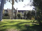
190 Vincent St North Perth
Cnr Camelia St
Vincent
Metropolitan
Constructed from 1903 to 1967
| Type | Status | Date | Documents |
|---|---|---|---|
| Heritage List | Adopted | ||
| State Register | Registered | 17 Mar 2006 | HCWebsite.Listing+ListingDocument, HCWebsite.Listing+ListingDocument |
| Type | Status | Date | Documents |
|---|---|---|---|
| (no listings) |
| Type | Status | Date | Grading/Management | |
|---|---|---|---|---|
| Category | ||||
| Municipal Inventory | Adopted | 13 Nov 1995 | Category A | |
Redemptorist Monastery and Church are generally in very good condition. The Retreat House is in fair condition with some deterioration of steelwork and staining to off form concrete work. The extensive gardens are tidy and well presented and the grounds are subsequently in fair to good condition.
| Name | Type | Year From | Year To |
|---|---|---|---|
| Michael and James Cavanagh & Parry, George (addition to east wing 1911) | Architect | - | - |
| Kierath Waldron | Architect | - | - |
| Library Id | Title | Medium | Year Of Publication |
|---|---|---|---|
| 9751 | Redemptorist Monastery and Church. | Heritage Study {Cons'n Plan} | 2011 |
Individual Building or Group
| Epoch | General | Specific |
|---|---|---|
| Present Use | RELIGIOUS | Church, Cathedral or Chapel |
| Present Use | RELIGIOUS | Monastery or Convent |
| Original Use | RELIGIOUS | Monastery or Convent |
| Original Use | RELIGIOUS | Church, Cathedral or Chapel |
| Style |
|---|
| Federation Gothic |
| Late 20th-Century Perth Regional |
| Type | General | Specific |
|---|---|---|
| Wall | BRICK | Other Brick |
| Wall | STONE | Limestone |
| Roof | TILE | Terracotta Tile |
| Roof | TILE | Other Tile |
| Wall | CONCRETE | Other Concrete |
| General | Specific |
|---|---|
| SOCIAL & CIVIC ACTIVITIES | Institutions |
| SOCIAL & CIVIC ACTIVITIES | Religion |
This information is provided voluntarily as a public service. The information provided is made available in good faith and is derived from sources believed to be reliable and accurate. However, the information is provided solely on the basis that readers will be responsible for making their own assessment of the matters discussed herein and are advised to verify all relevant representations, statements and information.
Constructed from 1900 to 1912
The Redemptorist Monastery & Chapel is an exemplar of the Federation Free Gothic style. It is, perhaps, the finest work of one of the most talented architects of the period, Michael Cavanagh, and bears comparison with other notable Catholic Monasteries and Seminaries. Set within spacious landscaped grounds, the place is a landmark, a grand and finely conceived civic work, which was also the centrepiece of a fine housing estate. It makes a singular contribution to the character of the suburb. The place demonstrates close associations with the Catholic Church, Bishop Gibney, Bishop Clune, the Redemptorist Fathers and Michael Cavanagh.
This substantial three storey building complex is symmetrically arranged about a south facing pedimented four storey entry tower with flanking corner towers. It is basically a three storey dormitory block with the large Chapel forming a western wing, matched by a projecting gabled eastern wing, to form a wide, but shallow, entry court. A further residential wing projects beyond the eastern gabled wing. The Chapel has a separate front entry in its south wall. The building is a vigorous and picturesque design with the rusticated walls set against dressed dado, dressed opening surrounds and mullions, dressed string courses, label moulds and parapet cappings. The composition is enlivened by the treatment of the windows on the third floor as gabled dormers, set against the tiled roof, tall dressed chimneys and corner tourelles on gables providing a silhouette of constant change and interest. The dormitory blocks are served by double height loggias, with twinned columns on tall plinths to both levels. On the upper level the balustrades span between the plinths. The entrance porch is capped with castellated pinnacles and a crucifix finial. The Chapel is in the form of a Latin Cross set north-south, with a great south window of five lancet windows supporting three wheel windows within a dressed Gothic arch, above a rusticated and crennelated entry porch, with diagonal stepped coner buttresses and smaller buttresses flanking the solid timber arched entry door. The south gable, with its decorated gable and cross finial is flanked by pinnacled towers. There is a side porch in the west transept. The western façade has a regular pattern of buttresses separating 5 bays with central lancet windows. Both the eastern and western transepts are gabled with great windows, narrower than the south window, with counter set and stepped corner buttresses. The sanctuary is housed in the semi-circular apse at the north end, formed with buttressed bays and a conical hipped roof. The complex is worthy of comparison with the notable St Patrick's Seminary, Manly, of 1885, designed by Sherrin and Hennessey. Set well back from the street in a landscaped setting with a central driveway None apparent
The Redemptorist Monastery and Chapel was built over several years in the early 1900s, for the Redemptorist Fathers, a Catholic order. The Chapel is situated in the western wing of the building. The place was designed by Michael and James Cavanagh, who were responsible for a number of buildings for the Catholic Church and its Orders. Father Thomas O'Farrell of the Redemptorist Fathers arrived in WA on 22 September 1899, at the invitation of Bishop Matthew Gibney. The Bishop intended to build them a monastery at Guildford, but Father O'Farrell did not hear well of the place and was encouraged by Father Ryan of the Oblate Fathers to go to Highgate Hill, where Bishop Gibney owned a number of houses. When the rest of the Redemptorist group arrived in October 1899, they took up residence in two adjoining houses at Highgate Hill (either Nos. 46-48 or Nos. 52-54 Vincent Street, or possibly both) and for the next four years ministered to the needs of the Highgate Hill parish, from the corrugated iron shed which served as the Sacred Heart Church at this time. During this period, Bishop Gibney decided that the Redemptorists should have a Church-owned property in Vincent Street, North Perth, due to its accessibility. However, the North Perth property was split by the undeveloped Chelmsford Road and had already been surveyed into housing allotments and the city sanitary dump adjoined the property. The authorities co-operated with the wishes of Bishop Gibney and the Vincent Street property was transferred to the Congregation of the Most Holy Redeemer as a single block. The City of Perth also resolved to relocate the sanitary dump and re-plan Chelmsford Road (extending from east to west) so as to leave the block intact. The Redemptorist Monastery and Church was opened on Sunday, 13 September 1903, with the Bishop Gibney and Abbot Torres from New Norcia officiating. The surrounding land was subdivided for residential development. New confessionals were installed in the Church circa 1917. In 1911-1912, the east wing was added. This was also designed by Michael and James Cavanagh. Contractor T. J. Green completed additions to the Church, including a sanctuary and transept in 1922 which were again designed by Michael and James Cavanagh. The shrine of Our Lady of Perpetual Help was erected in 1925 and the shrine of Little Flower was a later addition. In 1967 a retreat house designed by Kierath Waldron was completed. Later stand alone additions of meeting and dining rooms, kitchen and dormitory blocks were designed by Oldham Boas Ednie-Brown in the Postwar Brutalist style prevalent in Perth, c. 1970. In the 1990s, alterations were made to the ground floor monastery kitchen and the first and second floor bathrooms, and a new lift installed. Redemptorist Father Patrick Joseph Clune, a member of the group that had arrived in Western Australia in October 1899, served as Bishop of Perth from 21 December 1910 to 24 May 1935. The Wise's Post Office Directories indicate that the Superior/ Rector of the Redemptorist Monastery and Chapel changed several times over the years, including V. Rev Michael Hanagan (1925-1930, Superior), Rev Thomas Robinson (1931-1933, Superior), Rev Denis Grogan (1935-1940, Superior) and Rev F. J. Duffy (1941-1949, Rector). On 27 November 2008 the Redemptorist Monastery and Chapel suffered from a fire in Room 18 on the second floor. The repair works were supported by the Heritage Council subject to specific conditions.
Intact
| Name | Type | Year From | Year To |
|---|---|---|---|
| Michael Cavanagh | Architect | - | - |
This information is provided voluntarily as a public service. The information provided is made available in good faith and is derived from sources believed to be reliable and accurate. However, the information is provided solely on the basis that readers will be responsible for making their own assessment of the matters discussed herein and are advised to verify all relevant representations, statements and information.
220 Vincent St North Perth
cnr Vincent & Charles St
Beatty Aquatic Centre,
City of Perth Aquatic Centre
Vincent
Metropolitan
Constructed from 1962, Constructed from 1994
| Type | Status | Date | Documents |
|---|---|---|---|
| Heritage List | Adopted | ||
| State Register | Registered | 17 Dec 2004 | HCWebsite.Listing+ListingDocument, HCWebsite.Listing+ListingDocument |
| Type | Status | Date | Documents |
|---|---|---|---|
| (no listings) |
| Type | Status | Date | Grading/Management | |
|---|---|---|---|---|
| Category | ||||
| Other Legal Agreement | Under negotiation | 26 Feb 2004 | ||
| Municipal Inventory | Adopted | 13 Nov 1995 | Category A | |
| Name | Type | Year From | Year To |
|---|---|---|---|
| W A McI Green | Architect | - | - |
| Peter Hunt | Architect | - | - |
| Lionel H Steenbohm | Architect | - | - |
| Milton Boyce | Architect | - | - |
| Library Id | Title | Medium | Year Of Publication |
|---|---|---|---|
| 11982 | Beatty Park: celebrating the first fifty years 1962 - 2012 | Book | 2021 |
| 10193 | Modern Houses: Architect designed houses in Western Australia 1950 tpp 1960. | Book | 1997 |
| 9069 | A pictorial record of the VIIth British Empire and Commonwealth games. | Book | 1962 |
| 8808 | Beatty Park Leisure Centre : conservation plan. | Heritage Study {Cons'n Plan} | 2007 |
| 11948 | Beatty Park Leisure Centre | Heritage Study {Cons'n Plan} | 2018 |
Individual Building or Group
| Epoch | General | Specific |
|---|---|---|
| Present Use | SOCIAL\RECREATIONAL | Other Sports Building |
| Other Use | PARK\RESERVE | Park\Reserve |
| Original Use | SOCIAL\RECREATIONAL | Other Sports Building |
| Style |
|---|
| Late 20th-Century International |
| Late 20th-Century Structuralist |
| Type | General | Specific |
|---|---|---|
| Wall | METAL | Steel |
| Wall | GLASS | Glass |
| Wall | CONCRETE | Other Concrete |
| Wall | METAL | Aluminium |
| General | Specific |
|---|---|
| SOCIAL & CIVIC ACTIVITIES | Community services & utilities |
| SOCIAL & CIVIC ACTIVITIES | Sport, recreation & entertainment |
This information is provided voluntarily as a public service. The information provided is made available in good faith and is derived from sources believed to be reliable and accurate. However, the information is provided solely on the basis that readers will be responsible for making their own assessment of the matters discussed herein and are advised to verify all relevant representations, statements and information.
Constructed from 1962
Beatty Park Aquatic Centre and Recreation Ground is a fine example of a purpose designed, state of the art public facility for the 1962 Empire Games, in the Postwar International style, designed by the then City of Perth Town Clerk and City Engineer, W A MacInness Green. It also has associations with swimming events and championships, other water sports and events, and has social significance because it has been a focus of water sport in the local and wider community for 4 decades. The recreation ground is notable for its mature perimeter plantings which are significant townscape elements.
Comprises the three storey Aquatic Centre at the western end of the site and the Recreation Ground at the eastern end. The Aquatic Centre features glass-wall construction and extensive ceramic tile cladding. The U-shape design of the original building wraps around the main pool. It was extensively renovated in 1994 to provide facilities for recreational as well as sporting uses. The original building retains its original external character, which was characteristic of the Empire Games venues, with modular curtain wall facades with tinted windows and coloured spandrel panels. The Recreation Ground is an open grassed recreation area with perimeter plantings of mature trees, notably fig trees, which are a significant townscape element of the area. The main building is set diagonal across the corner. The setback areas comprise garden strips and hard surface driveways 1994 extensions and renovations
From the 1860s, problems with drainage and sanitation were of increasing concern in Perth as the town grew through the 1970s and 1880s. In March 1882, by-laws were passed controlling the disposal of night soil. On 4 December 1890 the area on the north side of Vincent Street, from Charles to Oxford Streets, where the Beatty Park is currently located, was gazetted as a Government reserve (Reserve 884) under the control of the Perth Board of Health. The area east of Loftus Street was used as a rubbish tip for some years in the 1890s, while the area along Oxford Street was parcelled off as sites for public buildings such as post office, municipal offices, primary school and police station. In 1905, the remainder of the land was vested in the City of Perth for the purpose of recreation. In 1906, Reserve 884 was classified as a Class 'A' for Recreational Purposes. It is probable that the earliest plantings at the site and its use as a recreational area date from this period. In 1920s, Reserve 884 was named Beatty Park in honor of Vice Admiral Sir David Beatty (later Earl), a World War One hero. In 1962, Perth hosted the British Empire and Commonwealth Games (known as Commonwealth Games from 1978) and the City of Perth Aquatic Centre, was built on the east side of Loftus Street as the venue for the swimming events. The newly-built centre incorporated every aspect of modern pool planning, including three pools, galleries for 5,500 spectators, a dramatic lighting system and a garden cafe. The chlorination plant was the most modern in Australia and an oil fuel heating unit kept the water temperature at 70 degrees Centigrade in all three pools. A Building Licence issued to the City of Perth in 1962 indicates that the cost of the construction for the Aquatic Centre was ₤564,000. H. A. Doust, City of Perth Town Clerk William Allan McInnes Green and City Architect Milton Boyce were responsible for planning the centre. An engineer and architect, W. A. McInnes Green designed the centre after months of study and an extensive overseas tour. The blue-tiled pool was 55 yards long, 24 yards wide, with 8 lanes. The diving pool was 30 metres by 20 metres with a depth sloping to 16 feet. It was a standard size for water polo events, had an air system to create artificial ripples, making it easier for a diver to judge his distances from the surface, and a special observation room with a 5ft square, 3 inch thick underwater window. An innovation for divers was an on-the-spot competitors room at the 3-metre board level, eliminating much of the long climb to the high-tower and walks to and from the dressing rooms. A glass wall enabled resting divers to see rivals in action. The third pool was for children. After the Games, the City of Perth Aquatic Centre, as Perth's premier swimming venue, was a popular and well-frequented place for recreational swimming, as well as hosting uncounted numbers of school sports days, summer holiday swimming lessons and swimming club meets, and providing a training ground for competitive swimmers. Throughout the 1960s and 1970s, the Aquatic Centre was the venue for beauty pageants, such as Miss Western Australia, and musical performances. In 1977, the Albert Spencer Pavilion was built in the park for the City of Perth. The Aquatic Centre was up-graded, with additional leisure facilities, to designs by architect Peter Hunt, for the City of Perth in 1993-1994, and was re-named Beatty Park Leisure Centre. Beatty Park Leisure Centre was extensively renovated in 1994 to provide more modern pool facilities. In mid 2003, Beatty Park Leisure Park continues in use as a leisure centre, and Beatty Park continues in use for recreation. In 2008 the Beatty Park Leisure Centre Conservation Plan and Beatty Park Redevelopment '“ Concept Plans were adopted by the Town of Vincent.
Moderate to High
| Name | Type | Year From | Year To |
|---|---|---|---|
| W A McInnes Green | Architect | - | - |
This information is provided voluntarily as a public service. The information provided is made available in good faith and is derived from sources believed to be reliable and accurate. However, the information is provided solely on the basis that readers will be responsible for making their own assessment of the matters discussed herein and are advised to verify all relevant representations, statements and information.
13 Woodville North Perth
Vincent
Metropolitan
| Type | Status | Date | Documents |
|---|---|---|---|
| (no listings) |
| Type | Status | Date | Documents |
|---|---|---|---|
| (no listings) |
| Type | Status | Date | Grading/Management | |
|---|---|---|---|---|
| Category | ||||
| (no listings) | ||||
Individual Building or Group
This information is provided voluntarily as a public service. The information provided is made available in good faith and is derived from sources believed to be reliable and accurate. However, the information is provided solely on the basis that readers will be responsible for making their own assessment of the matters discussed herein and are advised to verify all relevant representations, statements and information.
2 Woodville St North Perth
Vincent
Metropolitan
Constructed from 1925
| Type | Status | Date | Documents |
|---|---|---|---|
| Heritage List | Adopted |
| Type | Status | Date | Documents |
|---|---|---|---|
| (no listings) |
| Type | Status | Date | Grading/Management | |
|---|---|---|---|---|
| Category | ||||
| Municipal Inventory | Adopted | 12 Sep 2006 | Category B | |
Individual Building or Group
| Epoch | General | Specific |
|---|---|---|
| Original Use | RESIDENTIAL | Flats\Apartment Block |
| Present Use | RESIDENTIAL | Flats\Apartment Block |
| Other Use | HEALTH | Asylum |
| Type | General | Specific |
|---|---|---|
| Wall | BRICK | Face Brick |
| Other | TIMBER | Other Timber |
| Roof | TILE | Other Tile |
This information is provided voluntarily as a public service. The information provided is made available in good faith and is derived from sources believed to be reliable and accurate. However, the information is provided solely on the basis that readers will be responsible for making their own assessment of the matters discussed herein and are advised to verify all relevant representations, statements and information.
Constructed from 1925 to 1935
Casson House is a fine example of an institutional building of the period in the Federation Arts and Craft style. It demonstrates the purpose designed buildings then developed for institutional purposes. The place increases the stylistic variety while maintaining the predominant material palette of the area.
The double storey face brick structure has a gable roof that is clad with tiles. The main street façade is symmetrical with a central ground floor recessed entry above which there is the name of the place applied to the wall, and a bracketed window box, window and decorative arched panel above the window that is infilled with herringbone patterned brickwork. The gable is further defined by an open pediment. The windows throughout are sets of two double hung sashes on concrete sills with louvred timber shutters. Medium height face brick wall with decorative geometric pattern along the top and pillars each side of the palisade gate. Extensive planting in setback gardens. None apparent
Woodville Street was originally named Parker Street, and was part of the Woodville Estate, a residential subdivision in North Perth developed on Swan Location 653 by Solomon Herman and Thomas Whitton Williams in 1898. The Woodville Estate was the second subdivision in the area and was in the triangle formed by Angove, Farmer and Parker Streets. The subject place is first listed in the Wise's Post Office Directories in 1912 as No. 2 Parker Street, with Thomas T. Baxter, builder, as the occupier. Joseph A. Thomson (J. & T. Ltd) is listed at No. 2 Parker Street from 1913 to 1914. In 1915, Parker Street changed its name to Woodville Street and thereafter the address of the subject place changed to No. 2 Woodville Street. The subject place at No. 2 Woodville Street was occupied by Nurse Carslaw at that year. Mrs. C. H. Carslaw (Bute Private Hospital) and Stephen Carslaw are listed at the subject place between 1916 and 1917. Between 1918 and 1934, Joseph A. Thomson, JP (J. & T. & Co Ltd) is again listed at the subject site. A Metropolitan Water Supply Sewerage & Drainage Department (MWSSD) Plan dated 1914 illustrates that the then No. 2 Parker Street accommodated a brick building with a verandah ran the full length of the street frontage. A verandah was located at the rear central of the building. A brick stable was located at the north east corner of the site boundary. In 1935, Mrs. Susan Adelaide Casson purchased the subject property at No. 2 Woodville Street and the property was named Woodville Rest Home. Susan Casson, who was born in 1872, was appointed by the Government in 1920 as a lay member of the Board of Visitors to Claremont Hospital. Susan Casson convinced the Board of the necessity for discharge and rehabilitation into the community of some of the patients and for this purpose instigated the foundation of the '˜Mental Hospital After Care and Comforts Fund Association Incorporated'. She purchased the subject property in 1935, with the help of the Lotteries Commission for the sum of $3,600. The subject property was later named Casson House after Susan Casson. Today, the main façade of the subject place still carry the name of Casson House. When first purchased, the subject property accommodated seven patients. With the increasing demands for the beds, the subject place undertook several alterations and additions. In 1935, a hatched portion was added to the existing kitchen. In 1938, a side verandah, made of wood, asbestos and iron, was erected to the west of the subject Rest Home. Eventually, the association purchased the adjoining properties at No. 8 and No. 10 Woodville Street for future expansion over the years. The Wise's Post Office Directories list the subject place as the After Care Rest Home in 1935 and the Rest Home in 1940, with Sister Moncrieff and Nurse L. Enright as the person in charge respectively. Since then, the subject place is listed as Nos. 2-8 Woodville Rest Home until 1949. In addition to this, the Directories also reveal that Susan Casson is listed as the proprietor at No. 25 View Street, North Perth, which was proximate to Casson House. Susan Casson was appointed a Justice of the Peace in 1920 and was awarded the M.B.E. in 1949. In 1984, the name of the association was changed to Casson Homes Incorporated. At present, Casson Homes continues to operate under the guidance of a member of the Casson family. In 2008, Town of Vincent conditionally approved the planning application for proposed partial demolition of, and additions and alterations to the subject place.
High
This information is provided voluntarily as a public service. The information provided is made available in good faith and is derived from sources believed to be reliable and accurate. However, the information is provided solely on the basis that readers will be responsible for making their own assessment of the matters discussed herein and are advised to verify all relevant representations, statements and information.
165-171 Brisbane St Northbridge
Nos 165-167-169-171
Vincent
Metropolitan
Constructed from 1897
| Type | Status | Date | Documents |
|---|---|---|---|
| Heritage List | Adopted |
| Type | Status | Date | Documents |
|---|---|---|---|
| (no listings) |
| Type | Status | Date | Grading/Management | |
|---|---|---|---|---|
| Category | ||||
| Municipal Inventory | Adopted | 22 Dec 1997 | Category B | |
Individual Building or Group
| Epoch | General | Specific |
|---|---|---|
| Original Use | RESIDENTIAL | Conjoined residence |
| Present Use | RESIDENTIAL | Conjoined residence |
| Style |
|---|
| Old Colonial Georgian |
| Type | General | Specific |
|---|---|---|
| Wall | BRICK | Common Brick |
| Wall | BRICK | Rendered Brick |
| Roof | METAL | Corrugated Iron |
| Other | TIMBER | Other Timber |
| General | Specific |
|---|---|
| DEMOGRAPHIC SETTLEMENT & MOBILITY | Settlements |
This information is provided voluntarily as a public service. The information provided is made available in good faith and is derived from sources believed to be reliable and accurate. However, the information is provided solely on the basis that readers will be responsible for making their own assessment of the matters discussed herein and are advised to verify all relevant representations, statements and information.
Constructed from 1897
Nos. 165-171 Brisbane Street is a group of 4 dwellings designed in the form and style of a Late Colonial Georgian house. This form of development is consistent with comparable examples elsewhere in town centres from development in the pre Gold Boom period. The form of this group of dwellings is one of the oldest residential forms still existing in the district.
This group of 4 dwellings is designed in the form and style of a Late Colonial Georgian house. Originally there was little to distinguish the dwellings one from the other. This form of development is consistent with comparable examples of development in the pre Gold Boom period, in places like Busselton and Rockingham. The form of this group of dwellings is one of the oldest residential forms still existing in the district. The group has an extended hipped iron roof, with brick chimneys to the rear at either end. A detached skillion verandah runs the length of the façade, which is an extended Georgian exercise of well proportioned door and window openings set as symmetrically as possible.
The lots on the south side of this section of Brisbane Street bordered the edge of Lake Thomson (Mews Swamp) and the Brookman Street/Moir Street residential development of 1897. This was carried out by William Gordon Brookman's Colonial Finance Corporation betweeen Brookman, MOir and Lake street and Forbes Road. Brookman, Lord mayor of Perth (1900-01) had made his fortune in gold mining in Kalgoorlie. He was also deeply involved in the racing industry and later ran into financial troubles (partly due to his lavish lifestyle) and his properties had to be sold off to meet his debts. The two semi-detached pairs at Nos. 165-171 Brisbane Street appear on the 1897 PWD sewerage plans, but not on the 1897 City of Perth rate books. In the 1898 rate books they appear under the ownership of Goodman Nicholl. They are shown at this time as being on Perth Town Lot N17, as were 14 other houses and cottages. The correct lot number appears to be N14 or N15 (even the City's rate inspectors had trouble figuring out where they were sometimes). In 1898, the residences were numbered 65-71, and each semi-half was valued at £500. Tenants were Charles P. Burk (No.65), Alex Ross (No. 69) and George E. Watson, typist (No.71). No. 65 was vacant. Between 1907 and 1916, the houses were re-numbered 117-123. In 1916 they were given their current street address of Nos. 165-171 Brisbane Street and in 1918, the first year that they are listed in Wise's Post Office Directories as the current address, the residents were Mrs Ruby Oldfield (No. 165), Mrs Albinia Johanneson (No. 167), Henry Holland (No. 169) and Francis E. Tippett (No. 171). In 1949 the residents were Mrs Gwen Adams, Mrs Hazel Larsen, Alfred Snow and William Morphew.
Low/medium
This information is provided voluntarily as a public service. The information provided is made available in good faith and is derived from sources believed to be reliable and accurate. However, the information is provided solely on the basis that readers will be responsible for making their own assessment of the matters discussed herein and are advised to verify all relevant representations, statements and information.
36 Monger St Northbridge
Vincent
Metropolitan
| Type | Status | Date | Documents |
|---|---|---|---|
| (no listings) |
| Type | Status | Date | Documents |
|---|---|---|---|
| (no listings) |
| Type | Status | Date | Grading/Management | |
|---|---|---|---|---|
| Category | ||||
| Uniting Church Inventory | Completed | 01 Oct 1996 | ||
Individual Building or Group
| Epoch | General | Specific |
|---|---|---|
| Original Use | RESIDENTIAL | Single storey residence |
| Present Use | RESIDENTIAL | Single storey residence |
| Type | General | Specific |
|---|---|---|
| Roof | METAL | Corrugated Iron |
| Wall | BRICK | Rendered Brick |
| General | Specific |
|---|---|
| SOCIAL & CIVIC ACTIVITIES | Religion |
This information is provided voluntarily as a public service. The information provided is made available in good faith and is derived from sources believed to be reliable and accurate. However, the information is provided solely on the basis that readers will be responsible for making their own assessment of the matters discussed herein and are advised to verify all relevant representations, statements and information.
34 Palmerston St Northbridge
Allied and Leisure Warehouse
Vincent
Metropolitan
| Type | Status | Date | Documents |
|---|---|---|---|
| (no listings) |
| Type | Status | Date | Documents |
|---|---|---|---|
| RHP - Does not warrant assessment | Current | 13 Feb 2004 |
| Type | Status | Date | Grading/Management | |
|---|---|---|---|---|
| Category | ||||
| (no listings) | ||||
15858 Northbridge Precinct
Individual Building or Group
| Epoch | General | Specific |
|---|---|---|
| Present Use | COMMERCIAL | Warehouse |
| Original Use | COMMERCIAL | Warehouse |
This information is provided voluntarily as a public service. The information provided is made available in good faith and is derived from sources believed to be reliable and accurate. However, the information is provided solely on the basis that readers will be responsible for making their own assessment of the matters discussed herein and are advised to verify all relevant representations, statements and information.
135-137 Parry St Northbridge
ALSO PART OF 14590 NORTHBRIDGE URBAN RENEWAL AREA Moved from City of Perth to Town of Vincent Change gazetted 29/5/07
Vincent
Metropolitan
Constructed from 1910
| Type | Status | Date | Documents |
|---|---|---|---|
| (no listings) |
| Type | Status | Date | Documents |
|---|---|---|---|
| (no listings) |
| Type | Status | Date | Grading/Management | |
|---|---|---|---|---|
| Category | ||||
| Perth Draft Inventory 99-01 | YES | 31 Dec 1999 | ||
11543 Parry Street Precinct
Individual Building or Group
| Epoch | General | Specific |
|---|---|---|
| Present Use | RESIDENTIAL | Conjoined residence |
| Original Use | RESIDENTIAL | Conjoined residence |
| Style |
|---|
| Federation Queen Anne |
| Type | General | Specific |
|---|---|---|
| Roof | METAL | Steel |
| Wall | BRICK | Rendered Brick |
This information is provided voluntarily as a public service. The information provided is made available in good faith and is derived from sources believed to be reliable and accurate. However, the information is provided solely on the basis that readers will be responsible for making their own assessment of the matters discussed herein and are advised to verify all relevant representations, statements and information.
145 Parry St Northbridge
ALSO PART OF 14590 NORTHBRIDGE URBAN RENEWAL AREA Moved from City of Perth to Town of Vincent Change gazetted 29/5/07
Vincent
Metropolitan
| Type | Status | Date | Documents |
|---|---|---|---|
| (no listings) |
| Type | Status | Date | Documents |
|---|---|---|---|
| (no listings) |
| Type | Status | Date | Grading/Management | |
|---|---|---|---|---|
| Category | ||||
| Perth Draft Inventory 99-01 | YES | 31 Dec 1999 | ||
11543 Parry Street Precinct
Individual Building or Group
| Epoch | General | Specific |
|---|---|---|
| Original Use | RESIDENTIAL | Single storey residence |
| Present Use | RESIDENTIAL | Single storey residence |
This information is provided voluntarily as a public service. The information provided is made available in good faith and is derived from sources believed to be reliable and accurate. However, the information is provided solely on the basis that readers will be responsible for making their own assessment of the matters discussed herein and are advised to verify all relevant representations, statements and information.
147-149 Parry St Northbridge
ALSO PART OF 14590 NORTHBRIDGE URBAN RENEWAL AREA Moved from City of Perth to Town of Vincent Change gazetted 29/5/07
Vincent
Metropolitan
Constructed from 1910
| Type | Status | Date | Documents |
|---|---|---|---|
| (no listings) |
| Type | Status | Date | Documents |
|---|---|---|---|
| (no listings) |
| Type | Status | Date | Grading/Management | |
|---|---|---|---|---|
| Category | ||||
| Perth Draft Inventory 99-01 | YES | 31 Dec 1999 | ||
11543 Parry Street Precinct
Individual Building or Group
| Epoch | General | Specific |
|---|---|---|
| Present Use | RESIDENTIAL | Single storey residence |
| Original Use | RESIDENTIAL | Single storey residence |
| Style |
|---|
| Federation Queen Anne |
| Type | General | Specific |
|---|---|---|
| Roof | METAL | Steel |
| Wall | BRICK | Painted Brick |
This information is provided voluntarily as a public service. The information provided is made available in good faith and is derived from sources believed to be reliable and accurate. However, the information is provided solely on the basis that readers will be responsible for making their own assessment of the matters discussed herein and are advised to verify all relevant representations, statements and information.
Stuart St Northbridge
corner of Fitzgerald and Stuart, in park area, near skating ramp.
Vincent
Metropolitan
| Type | Status | Date | Documents |
|---|---|---|---|
| Heritage List | Adopted |
| Type | Status | Date | Documents |
|---|---|---|---|
| (no listings) |
| Type | Status | Date | Grading/Management | |
|---|---|---|---|---|
| Category | ||||
| Municipal Inventory | Adopted | 28 Jun 2016 | Category A | |
23992 Metropolitan Sewerage Vents
Ornate circular cast iron base with fluting and moulding, and containing the letters M S (Metropolitan Sewerage) in the lower portion. Above is a straight circular pipe braced by four metal rods that rise out of the base. There is some damage and holes present to the circular pipe. The base has been repainted, bronze with black lettering.
Other Built Type
| Epoch | General | Specific |
|---|---|---|
| Original Use | GOVERNMENTAL | Other |
| Type | General | Specific |
|---|---|---|
| Other | METAL | Cast Iron |
| General | Specific |
|---|---|
| SOCIAL & CIVIC ACTIVITIES | Community services & utilities |
| DEMOGRAPHIC SETTLEMENT & MOBILITY | Settlements |
This information is provided voluntarily as a public service. The information provided is made available in good faith and is derived from sources believed to be reliable and accurate. However, the information is provided solely on the basis that readers will be responsible for making their own assessment of the matters discussed herein and are advised to verify all relevant representations, statements and information.
This information is provided voluntarily as a public service. The information provided is made available in good faith and is derived from sources believed to be reliable and accurate. However, the information is provided solely on the basis that readers will be responsible for making their own assessment of the matters discussed herein and are advised to verify all relevant representations, statements and information.
bounded by Aberdeen, Newcastle & Parry sts from Lord to Fitzgerald sts Northbridge & Perth
Newcastle, Aberdeen & Beaufort Streets, Fitzgerald, Palmerston, Lake & William Sts, Money, Lindsay, Stirling & Pier Places within this area may have separate individual heritage listings.
Vincent
Metropolitan
| Type | Status | Date | Documents |
|---|---|---|---|
| (no listings) |
| Type | Status | Date | Documents |
|---|---|---|---|
| RHP - Does not warrant assessment | Current | 26 Sep 2003 |
| Type | Status | Date | Grading/Management | |
|---|---|---|---|---|
| Category | ||||
| (no listings) | ||||
| Library Id | Title | Medium | Year Of Publication |
|---|---|---|---|
| 7639 | Planning assessment report : lots 608 & 610 Newcastle Street, Northbridge | Report | 2005 |
| 6998 | Northbridge action plan 2003 - 2007. | Report | 2003 |
| 5902 | City of Perth Council Minutes 14 March 2000. | Report | 2000 |
| 4741 | Northbridge Urban Redevelopment project : conservation report. | Heritage Study {Other} | 2000 |
| 5710 | Northbridge : the master plan - October 2000. | Report | 2000 |
| 7752 | Photographic archive of Ada, Arthur and Alfred: lot 307 Newcastle Street, Northbridge. | Archival Record | 2005 |
Precinct or Streetscape
| Epoch | General | Specific |
|---|---|---|
| Present Use | COMMERCIAL | Other |
This information is provided voluntarily as a public service. The information provided is made available in good faith and is derived from sources believed to be reliable and accurate. However, the information is provided solely on the basis that readers will be responsible for making their own assessment of the matters discussed herein and are advised to verify all relevant representations, statements and information.
Perth
Perth
Metropolitan
Constructed from 1914 to 1915
| Type | Status | Date | Documents |
|---|---|---|---|
| (no listings) |
| Type | Status | Date | Documents |
|---|---|---|---|
| RHP - Assessed - Consultation (Preliminary) | Current | 16 Jun 2016 |
| Type | Status | Date | Grading/Management | |
|---|---|---|---|---|
| Category | ||||
| (no listings) | ||||
Electricity Substations, Perth, a non-adjacent group of four two-storey red brick buildings with stucco detailing, in the Federation Warehouse style, constructed to a standard plan that was modified to suit each location, has cultural heritage significance for the following reasons: the four buildings are a rare example of a complete set of early twentieth-century electricity substations relating to the initial development of an electricity network in Western Australia; the four buildings were constructed by Perth City Council to operate as the main line substations in conjunction with the State Government’s East Perth Power Station (1916), the first centralised electricity supply in Perth, and one (No.4 Substation, Stuart Street) continued to operate as an electricity substation into the twenty-first century; the four buildings have high scientific value for their ability to contribute to the understanding of the development of power to the metropolitan region of Perth, especially No.4 Substation, Stuart Street, which retains much of its transformers and other machinery; the four buildings are good examples of utilitarian structures designed in the Federation Warehouse style to fit within city streetscapes, an approach to constructing and siting industrial buildings that is no longer practised; construction of the substations and installation of the plant was supervised by international company Merz & McLellan, especially Charles McLellan, who advised the City of Perth and State Government regarding electricity production and was influential in the decision to centralise and to switch from direct to alternating current; and, the buildings were designed by prominent and prolific Western Australian architect Jack Learmonth Ochiltree and are a good example of his design approach to functional buildings.
Electricity Substations, Perth comprises a non-adjacent group of four two-storey red brick buildings with stucco detailing, in the Federation Warehouse style, constructed to a standard plan that was modified to suit the location of each building. The buildings are sited within central Perth, between one and 1.5 kilometres from each other. They were constructed for Mertz and McLellan in 1914 and 1915, designed by Jack Ochiltree and constructed by Todd Brothers.
Electricity Substations, Perth were constructed for Mertz and McLellan in 1914 and 1915, designed by Jack Ochiltree and constructed by Todd Brothers.
No. 4 Substation, Stuart Street displays a high degree of integrity. It was used as an electricity substation until relatively recently and was only decommissioned when new technology made it redundant. It retains most of the operating machinery used until the decommissioning of the building, when it was mothballed. No. 1 Substation, Wellington Street and No. 3 Substation, Colin Street have been considerably modified to suit other uses. No.2 Substation, Murray Street has had its plant removed and is now vacant, but the layout of the substation remains intact. No. 4 Substation, Stuart Street displays a very high degree of authenticity. The street frontages retain their original form and the internal spaces retain their original volumes. Some original machinery remains in situ. There have been some alterations over time, both to the building and the machinery, that reflect the development of electricity generation and distribution to a large metropolitan area. While there have been a number of modifications to No. 1 Substation, Wellington Street and No. 3 Substation, Colin Street, particularly the introduction of mezzanine levels and the painting of the facades of No. 1 Substation, Wellington Street the original layout, façade details and volumes are discernable and the buildings could be returned to their original form if required. No.2 Substation, Murray Street largely retains its original form and detail, with some windows blocked up or replaced and the first floor balcony enclosed.
Electricity Substations, Perth comprises four buildings, all in good condition. They were very well constructed using high quality materials and were designed to a very high structural specification. They have all been well maintained although No. 1 Substation, Wellington Street and No. 4 Substation, Stuart Street require some cosmetic maintenance.
Individual Building or Group
| Epoch | General | Specific |
|---|---|---|
| Present Use | GOVERNMENTAL | Power Station |
| Present Use | VACANT\UNUSED | Vacant\Unused |
| Present Use | RESIDENTIAL | Flats\Apartment Block |
| Original Use | GOVERNMENTAL | Power Station |
This information is provided voluntarily as a public service. The information provided is made available in good faith and is derived from sources believed to be reliable and accurate. However, the information is provided solely on the basis that readers will be responsible for making their own assessment of the matters discussed herein and are advised to verify all relevant representations, statements and information.
225-227 & 235-241 Beaufort St Perth
Comprises P3133 & P3134 which were later permanently registered individually.
Forrest Lodge
Trained Nurses Home
Vincent
Metropolitan
Constructed from 1896
| Type | Status | Date | Documents |
|---|---|---|---|
| State Register | Removed | 08 Aug 2008 | HCWebsite.Listing+ListingDocument |
| Type | Status | Date | Documents |
|---|---|---|---|
| (no listings) |
| Type | Status | Date | Grading/Management | |
|---|---|---|---|---|
| Category | ||||
| (no listings) | ||||
Genrally Beaufort Street terraces have been well maintained. Nos. 235 and 237 are in very good condition and the external condition of the remaining places seems fair, but the condition of the interiors has not been ascertained. Overall the place is in good condition.
Individual Building or Group
| Epoch | General | Specific |
|---|---|---|
| Original Use | COMMERCIAL | Other |
| Present Use | RESIDENTIAL | Conjoined residence |
| Present Use | COMMERCIAL | Shop\Retail Store {single} |
| Original Use | RESIDENTIAL | Terrace housing |
| Style |
|---|
| Federation Filigree |
| Type | General | Specific |
|---|---|---|
| Wall | BRICK | Common Brick |
| Roof | METAL | Corrugated Iron |
| Wall | METAL | Aluminium |
| Wall | STONE | Other Stone |
| Wall | TIMBER | Weatherboard |
| General | Specific |
|---|---|
| OCCUPATIONS | Hospitality industry & tourism |
| OCCUPATIONS | Domestic activities |
| OCCUPATIONS | Commercial & service industries |
This information is provided voluntarily as a public service. The information provided is made available in good faith and is derived from sources believed to be reliable and accurate. However, the information is provided solely on the basis that readers will be responsible for making their own assessment of the matters discussed herein and are advised to verify all relevant representations, statements and information.
129 & 133-135 Lake St Perth
Vincent
Metropolitan
Constructed from 1897
| Type | Status | Date | Documents |
|---|---|---|---|
| (no listings) |
| Type | Status | Date | Documents |
|---|---|---|---|
| (no listings) |
| Type | Status | Date | Grading/Management | |
|---|---|---|---|---|
| Category | ||||
| (no listings) | ||||
Individual Building or Group
| Epoch | General | Specific |
|---|---|---|
| Present Use | RESIDENTIAL | Single storey residence |
| Original Use | COMMERCIAL | Shop\Retail Store {single} |
| Original Use | RESIDENTIAL | Single storey residence |
| Type | General | Specific |
|---|---|---|
| Roof | METAL | Corrugated Iron |
| Wall | BRICK | Common Brick |
| Wall | BRICK | Rendered Brick |
| General | Specific |
|---|---|
| OCCUPATIONS | Commercial & service industries |
This information is provided voluntarily as a public service. The information provided is made available in good faith and is derived from sources believed to be reliable and accurate. However, the information is provided solely on the basis that readers will be responsible for making their own assessment of the matters discussed herein and are advised to verify all relevant representations, statements and information.
3, 5-7, 9, 11, 13, 17, 19 Bulwer Av Perth
This place record does NOT contain 1 & 21 Bulwer Av (This record is created based on the MI record). The parent record P8594 (DOES contain 1 & 21 Bulwer Av) and is in the HCWA Assessment Program.
Vincent
Metropolitan
Constructed from 1895, Constructed from 1922
| Type | Status | Date | Documents |
|---|---|---|---|
| Heritage List | YES | 12 Sep 2006 |
| Type | Status | Date | Documents |
|---|---|---|---|
| (no listings) |
| Type | Status | Date | Grading/Management | |
|---|---|---|---|---|
| Category | ||||
| Municipal Inventory | Adopted | 12 Sep 2006 | Category A | |
08594 Bulwer Avenue Precinct
Individual Building or Group
| Epoch | General | Specific |
|---|---|---|
| Present Use | RESIDENTIAL | Single storey residence |
| Original Use | RESIDENTIAL | Single storey residence |
| Style |
|---|
| Federation Anglo-Dutch |
| Federation Arts and Crafts |
| Type | General | Specific |
|---|---|---|
| Wall | BRICK | Common Brick |
| Wall | STONE | Limestone |
| Roof | METAL | Corrugated Iron |
| Other | TIMBER | Other Timber |
| General | Specific |
|---|---|
| DEMOGRAPHIC SETTLEMENT & MOBILITY | Settlements |
| DEMOGRAPHIC SETTLEMENT & MOBILITY | Land allocation & subdivision |
This information is provided voluntarily as a public service. The information provided is made available in good faith and is derived from sources believed to be reliable and accurate. However, the information is provided solely on the basis that readers will be responsible for making their own assessment of the matters discussed herein and are advised to verify all relevant representations, statements and information.
Constructed from 1895 to 1922
Bulwer Avenue Group is a notable and intact turn of the twentieth century development of detached houses in the Federation Anglo Dutch and Arts & Crafts styles, which occupies the length of a whole streetblock opposite the Highgate Primary & Infant Schools. The subdivision was made possible by transfering a strip of land from the schools to enable Bulwer Avenue to be developed as a public road.
This small precinct runs along the west side of Bulwer Avenue opposite Highgate Primary School. The west side of Bulwer Avenue comprises of 10 houses, one with an attached shop (there is no house numbered 7 in the street), however the house and shop attached at No.1 Bulwer Avenue and the house at No. 21 Avenue have not been included in the heritage listing as a result of a resoultion made at an Ordinary Meeting of Council held on 7 November 2006. The houses were all built in either one of two distinct building styles. There are two sets of three almost identical Federation Arts and Crafts style houses at each end of the block, and a set of four Federation Anglo Dutch style houses in the centre of the street. The houses are all double fronted, with gabled projections and simple verandahs. The Federation Anglo Dutch style houses are of stone, with brick quoins and a faceted bay window under a Dutch gable. The houses have pairs of chimneys and four paneled timber front doors. Original windows are double hung. The Federation Arts and Crafts style influenced houses are of a similar design but their front bays are treated as low parapeted towers roofed with a mitred hip. The group has a continuous 4.5 metre setback from the street with residential garden settings. No. 19 has been altered to appear as a Federation Bungalow style residence. No. 11 has been converted and enlarged to form two separate residences.
Bulwer Avenue and Bulwer Street were named in 1858 after Sir Edward Bulwer Lytton, first Baron Lytton, a 19th Century novelist. Lytton was Secretary for State for the Colonies during the years 1858 - 59. part of this road was formerly in the locality of East Perth, but due to boundary changes, it is now in the locality of Perth. Ten houses were built on the west side of Bulwer Ave between 1895 and 1898, on part of Lots N115 and N139, in the area known originally as Highgate Hill. Opposite was the Highgate Primary School, which opened in 1895. The rapid rise in resident numbers in the area was reflected in a rapid increase in principals at the school. So much so that a separate infants's school was built in 1900 and addtion to both schools followed until 1913. In 1922, a shop was added to the residence at No 1. The land on Bulwer Avenue was owned by Anastasia Murphy. Anastasia and her husband Michael, with their six children, had established a market garden in the area. Following Michael's death in 1880, Anastasia continued to lease out the land for gardening. In the early 1890s, she subdivided some of it, creating the Bulwer Park Villa subdivision. Hall, Dallen & Todd Ltd, land and real estate agents, handled the sale of the lots. H. C. Ashton, of Ashton Brothers Contractors, built No. 1, and may have been responsible for the other houses of the same design. A number of the houses were given names, such as 'Dovedale' (No.11), 'Lytton' (No.15), 'Atherstone' (No. 1), 'Roylyn' (No.3), 'Boscobel' (No.5) and 'Bronte' (No.17). In the Post Office Directory for 1897 Harry L. Hall, Joseph Hine and Hentry G. Trenchard are listed as living in the street plus George R. Turner at 'Lytton'. No numbers are given. In 1901, the occupants of the houses were a manager, agent, clerks, a civil servant, solicitor, engineer and gentleman. These people were representative of the middle class in Perth at this time. In 1922, the shop at No. 1 was leased to Ida James, who ran a confectionary business for a short time. In 1949 the residents were Arthur Cochrance, a painter (No.3), Mrs Flora A .Goddard (No. 50, Mrs Mary Thornton (No. 9), H.J Hartshorn at No. 11 and Mrs M.E Detrich at No. 11a, Edward G. Lewis and Mrs Lilly Lee at No. 15, Mrs Maria and Burns Noble (No. 27) and Mrs Ivy Wiley (No. 19). European migrants occupied some of the houses in the 1950s and 1960s, and David Helfgott's family lived at No. 13 during this period. A number of the houses have been upgraded in recent years, and more are owner-occupied.
Mostly intact or redeemable
This information is provided voluntarily as a public service. The information provided is made available in good faith and is derived from sources believed to be reliable and accurate. However, the information is provided solely on the basis that readers will be responsible for making their own assessment of the matters discussed herein and are advised to verify all relevant representations, statements and information.
43-45 & 51-53 Robinson Av Perth
Vincent
Metropolitan
Constructed from 1895
| Type | Status | Date | Documents |
|---|---|---|---|
| Heritage List | YES | 12 Sep 2006 |
| Type | Status | Date | Documents |
|---|---|---|---|
| (no listings) |
| Type | Status | Date | Grading/Management | |
|---|---|---|---|---|
| Category | ||||
| Municipal Inventory | Adopted | 12 Sep 2006 | Category B | |
Individual Building or Group
| Epoch | General | Specific |
|---|---|---|
| Present Use | RESIDENTIAL | Conjoined residence |
| Original Use | RESIDENTIAL | Conjoined residence |
| Style |
|---|
| Federation Bungalow |
| Type | General | Specific |
|---|---|---|
| Wall | BRICK | Face Brick |
| Wall | BRICK | Rendered Brick |
| Other | TIMBER | Other Timber |
| Roof | METAL | Corrugated Iron |
| Other | METAL | Aluminium |
This information is provided voluntarily as a public service. The information provided is made available in good faith and is derived from sources believed to be reliable and accurate. However, the information is provided solely on the basis that readers will be responsible for making their own assessment of the matters discussed herein and are advised to verify all relevant representations, statements and information.
Constructed from 1895
The semi-detached dwellings at Nos. 43 - 45 and Nos. 51 - 53 Robinson Avenue are a cohesive group of two similar semi-detached mirror pair duplexes. They are an unusual group example of intact Federation bungalow duplexes whose rhythum, scale, form and fabric contribute to the character of the area.
The single storey semi-detached houses at Nos. 43 - 45 and 51 - 53 Robinson Avenue are constructed in brick with double hipped roofs that extend into skillions at the rear. In both the dwellings a skillioned front verandah spans the full width of the street facade. The semi-detached dwelling at Nos. 43 - 45 Robinson Avenue features a rendered and capped dado wall supported by half height Doric columns. The dado wall follows the slope of the ground and the columns vary in height to provide a common height for the bressemer. The verandah at Nos. 51 - 53 Robinson Avenue is supported by timber posts. In both the dwellings the front doors are set near to the common wall and the remaining one room frontage has a central double hung window. The double hung windows in the dwelling at Nos. 51 - 53 Robinson Avenue has been replaced with aluminium frame windows. The chimneys in both dwellings are tall with a rendered base and rendered moulded corbel. Low rendered fence and gates small setback - one duplex steps down from footpath. Various: an aluminium framed window, chimney removed, verandah columns and dado.
During the Gold Boom period in Perth a demand for rental accommodation within walking distance to job opportunities and city services increased. A survey of the Wise Postal Directories indicates that there was a considerable mobility of residents in the area, suggesting that many were rented homes. The two semi-detached pairs at Nos. 43 - 45 and 51 - 53 Robinson Avenue fits the above criteria well with a high turn over of tenancy from the 1890's throughout the first part of the 20th century evident. This section of Robinson Avenue between William and Lake Streets was originally called Cicely Street until 1910 when it became an extension of Robinson Avenue. The 1897 Perth Metropolitan Sewerage Plans show the semi-detached dwellings at Nos. 43 - 45 and Nos. 51 - 53 together with Nos. 47 - 49 to be the only dwellings to have been constructed in this section Robinson Avenue (then Cicely Street), between Lake Street and William Street at this time. By 1901 the Perth Metropolitan Sewerage Plans indicate that a number of other dwellings to have been constructed by this time along this northern section of Robinson Avenue (then Cicely Street). This development pattern correlates with the information within the Wise Postal Directories. The two semi-detached pairs are first listed in the Wise Postal Directories in 1899. As the numbering of the dwellings has changed considerably since this time it is difficult to ascertain with certainty who resided at each of the dwellings, however it can be assumed that in 1899 a Mr Sydney Lawrence resided at No. 1(No. 43); Mr John Starr at No. 3(No. 45) and an artist Ms Val Delawarr at No. 9 (No. 53). By 1900 all four dwellings were occupied with Ms Mary Carlisle at No. 1 (No. 43), Mr John Starr at No. 3 (No. 45), Mr Albert Hugo at No. 9 (No. 51) and Mr Charles Fane at No. 11 (No. 53). In 1901 the tenants change again with only Mr John Starr at No. 3 (No. 45) who remains at the dwelling until 1903. By 1905 all the residents changed again and the numbering has as well. A Mr Lanham resides at No. 39 (No. 43), a Mr Ruthven at No. 41 (No. 45), a Mr Jonothon Peat at No. 47 (No. 51) and a decorator Mr J.W Gibson at No. 49 (No. 53). By 1912 the numbering of the dwellings correlates with how it appears today with a Mr Jonothon McDiarmid at No.43, Mr Hector Smart at No. 45, Mrs Farrant resides at No. 51 and Mr James Billings at No. 53. Throughout this decade the tenancy changes rapidly with most occupancy lasting just one or two years. Those who maintain longer tenancy include Mr Hector Smart who resides at No. 45 from 1910 until 1915. Another comparatively long term resident is Mrs Weston who resides at No. 49 Robinson Avenue from 1915 until 1926. During the 1920s occupancy of the dwellings continues to be quite fluid with most tenants residing at the dwellings for only a couple of years. In 1926 a Mr Jonothon Crag resides at No. 43, William Auckttle resides at No. 51 and Mr Frank Blore at No. 53 and by the following year only Mr William Auckttle remains in residence. These patterns of tenancy continue throughout the 1930's and 1940's. In 1934 a Mr Joseph Greenberg resides at No. 43 who resides at the dwelling from 1929 - 1939, Frank Bogue at No. 49, Mr Mullarley at No. 51 and Andrew Dunsire at No. 53 who resides at the dwelling from 1933 until 1938. In 1946 a Mrs Ellen Moore resides at No. 43, Mrs Sarah Milligan at No. 45, Mrs Edna Ivery at No. 51 and a Mr Spencer at No. 53 most of whom remain in residence until at least 1949. It is assumed that the dwellings have remained as predominately rental accommodation until the present day.
High degree
This information is provided voluntarily as a public service. The information provided is made available in good faith and is derived from sources believed to be reliable and accurate. However, the information is provided solely on the basis that readers will be responsible for making their own assessment of the matters discussed herein and are advised to verify all relevant representations, statements and information.
1-19 Baker Av Perth
Nos. 1,3,5,7,9,11,13,15,17,19
Vincent
Metropolitan
Constructed from 1928
| Type | Status | Date | Documents |
|---|---|---|---|
| Heritage List | Adopted |
| Type | Status | Date | Documents |
|---|---|---|---|
| (no listings) |
| Type | Status | Date | Grading/Management | |
|---|---|---|---|---|
| Category | ||||
| Municipal Inventory | Adopted | 03 Jul 2006 | Category B | |
Individual Building or Group
| Epoch | General | Specific |
|---|---|---|
| Present Use | RESIDENTIAL | Single storey residence |
| Original Use | RESIDENTIAL | Single storey residence |
| Style |
|---|
| Inter-War California Bungalow |
| Type | General | Specific |
|---|---|---|
| Wall | BRICK | Common Brick |
| Roof | TILE | Other Tile |
| General | Specific |
|---|---|
| DEMOGRAPHIC SETTLEMENT & MOBILITY | Settlements |
This information is provided voluntarily as a public service. The information provided is made available in good faith and is derived from sources believed to be reliable and accurate. However, the information is provided solely on the basis that readers will be responsible for making their own assessment of the matters discussed herein and are advised to verify all relevant representations, statements and information.
Constructed from 1928
Baker Avenue has some aesthetic significance as a cohesive row of dwellings exhibiting characteristics of the Inter-war bungalow style of architecture, which face Birdwood Square and provides a coherent character with varied detail. The dwellings contribute to the quality and setting of the surrounding area, and provide an important contribution to the vista of Birdwood Square. Its aesthetic qualities as a whole are defined by the overall form, style, height, setback and selection of materials of the place in contributing to the uniformity of the streetscape. Baker Avenue has some historic value as the dwellings were developed at a time when there was a change of focus of suburban development from development driven by land speculation to planned communities with particular emphasis placed on amenity as encouraged through the Garden City movement
Baker Avenue is located opposite Birdwood Square and runs perpendicular to Brisbane and Vincent Streets in Perth. The avenue comprises ten brick and tile Inter-war bungalows, which have a consistent setback and lot configuration, which responds to the slight curve in the avenue. Whilst all the dwellings along the street have different design features and presentations to the street there are a number of common elements, which include: gable ends with decorative battens in a vertical orientation; verandahs, which are supported by rendered brick piers with columns above, tiled roofs; timber casement window arrangements with mullion detail and consistent side setbacks. Only two owners of the properties along Baker Avenue contacted the Town to enable a site inspection to be undertaken. A number of original Building Licence plans have been located for the dwellings, which provide a good understanding of the form and layout of the dwellings. These plans are contained in Appendix 3 of this assessment. The majority of dwellings along the street have retained much of their original form, detailing and presentation to the street with the exception of two of the dwellings. The dwelling at No. 1 (Lot 2) Baker Avenue, which is located at the southern end of the avenue and has a side frontage to Brisbane Street, is completely concealed behind a garage and brick wall, which was constructed circa 1995. The place at No.3 Baker Avenue has had a second storey timber addition, which is well setback and comprises a white corner window and chimney. There are two high brick walls, which obscure the facades of Nos. 17 and 19 Baker Avenue. Baker Avenue is located opposite Birdwood Square and runs perpendicular to Brisbane and Vincent Streets in Perth. The avenue comprises ten brick and tile Inter-war bungalows, which have a consistent setback which responds to the slight curve in the avenue. Along the eastern side of Birdwood Square is Beaufort Street, which comprises a number of places on the Town's Municipal Heritage Inventory including; the Brisbane Hotel and Bowra O'Dea's Funeral Parlour. The existing pattern of development along the section of Brisbane Street near No. 1 Baker Avenue is characterised by a mix of dwellings constructed during the Gold Boom period in Perth (1890 - 1915) including Federation Arts and Craft Bungalows, semi-detached and single dwellings constructed in the Federation Georgian Style, together with more recently constructed commercial and residential properties and former municipal buildings such as the Brisbane Street Post Office, which has been adapted for alternative use and the Co-Masonic Hall. Birdwood Square backs onto the north east section of the street. Various
Birdwood Square is a place of cultural significance to the Nyoongar people. Named Chalyeding, the area was once a system of inland lakes, swamps and lagoons which extended from East Perth across the northern part of the city. These wetlands sustained the Nyoongar people during the late spring, summer and early autumn months when fresh water reserves ran low and food was plentiful. The wetlands were important for accommodating gatherings where trade and ceremonies took place. Other lakes and swamps in the immediate northern vicinity of the early Perth township were Lake Kingsford (site of the current Perth railway station), Lake Irwin (Perth Entertainment Centre), Lake Thomson (Mews Swamp between Lake, Brisbane and Beaufort Streets) and Lake Henderson (parts of what is now Robertson Park and Dorrien Gardens). Birdwood Square was originally known as '˜First Swamp' by the early European settlers. It was renamed Lake Poulett after the Fourth Earl of Poulett in the early 1800s, as it was fashionable for streets and parks to be named after English dignitaries at the time. It was also referred to casually as Lakey's Garden in later years. The lake was drained circa 1872 after severe flooding in the city. It was partially filled during one period of use as the town rubbish dump, but it is understood that there was a nursery established there at some stage. Later Chinese market gardeners began growing produce there. The Chinese were the first ethnic group to move into the North Perth area during the Western Australian gold boom in the early 1890s. The fertile soil and plentiful water supply of the drained wetlands were ideally suited to traditional Chinese farming methods. This enabled them to meet the demand for fresh fruit and vegetables resulting from the expansion of Perth's population to the north. One of the Chinese market gardeners at Birdwood Square was Joes Kong. He farmed the garden at the intersection of Bulwer and Beaufort Streets, until it was purchased by the City of Perth in 1913. As can be seen from early Perth Water Department Plans, there were a number of structures built along the south-eastern corner of Birdwood Square at the junction of Brisbane and Beaufort Streets circa 1897. However, these dwellings were demolished presumably for the creation of Birdwood Square in 1913 when the surrounding Chinese market gardens were purchased by the City of Perth in 1913. By this time (1913), the City of Perth was actively purchasing Chinese market gardens in the North Perth area for conversion into public parks and reserves. This was the result of the '˜City Beautiful' philosophy promoted by the visionary Town Clerk, W. E. Bold, in the early 1900s. The philosophy was picked up in the City of Perth's General Purposes Committee report in 1906, which stated that there was 'no responsibility more important than attending to the parks and reserves, which in all the big centres of population add so materially to the beauty of the city and so much to the pleasure of people. These occasional splashes of green turf, umbrageous trees and cool waters, standing out in pleasant relief from the sordid monotony of dense settlement, dust and smoke, are well called 'lungs of the city'. No vision of the city beautiful - the ideal centre for comfortable, convenient and pleasurable living is without such oasis in the desert of grassless roads of asphalt, closely packed houses and smoke vomiting factories.' There was also deep feeling within the community that the Chinese gardens (partly because of their use of human manure) were unsanitary and a health hazard. Bold undertook a tour of Britain and North America to gather information about municipal experiments and improvements. On his return he further developed his 'Greater Perth' concept to embrace satellite garden and seaside suburbs, and an overall plan on 'City Beautiful' lines. The 'Greater Perth' movement was implemented during World War I when Leederville, North Perth and Victoria Park joined the city; the inner suburb of Subiaco resolved to remain independent. In the mid-1920s the Council, at Bold's suggestion, invited the architects Hope and Klem to design satellite towns on the new lands at Floreat Park, Wembley Park and City Beach. It is understood that Birdwood Square was re-named in honour of Sir William Riddell Birdwood, who served as a Commander of the Anzacs in Gallipoli during the World War 1. At this time, Sir William was a household name in Australia. London Plane trees (Platanus acerifolia) were planted along the street boundaries of Birdwood Square as typical of the period. 'At the time, interesting specimen trees were used in lawns and to close off and create vistas.' Jacaranda and Brush box trees were planted along Baker Avenue as the latter were believed to be eminently suitable for street trees. The City of Perth Metropolitan Sewerage Map Plans indicate that Baker Avenue was not extant at the beginning of the 20th century and formed part of a large area, which was used for Chinese market gardening. The Wise Post Office Directory first list Baker Avenue in 1928. One can conclude from the above discussion that Baker Avenue was developed at a time when there was a change of focus of suburban development from development driven by land speculation, to planned communities with particular emphasis placed on amenity as encouraged through the Garden City movement. There are no records or references, which suggests that the subject dwellings were directly associated with W.E Bold who promoted the concepts of the Garden City. There are five people listed as occupants of the street in 1928, when it is first listed in the Wise Post Office Directory. The occupants were; Francis Green, John P.Waters, Oliver H. Crenllin, Henry Kell and Frank Hahn. No numbers were listed at this time It appears that by 1930 the whole street had been built out with the following occupants; Morris Hoffman at No. 1 Baker Avenue; No. 3 not listed; Sylvester Lane at No. 5; Dennis Fitzgerald at No. 7; John Waters at No. 9; Oliver Crenllin at No.11, Jesse Lawrence at No. 13; Robert Leslie at No. 15; Henry Kell at No. 17 and Frank Hahn at No.19. In 1938 the residents were Morris Hoffman (No.1), R.J Basstion (No.30, Mrs Elizabeth Gilligan (No. 5), Dennis Fitzgerald (No.7), John P. Water (No. 9), Charles I. Watson (No. 11), Ron Turville (No. 13), Mrs E Leslie (No. 15), Henry A. Kell (No. 17) and Frank B. Dungey (No. 19), who apparently worked in a salt refinery. In 1949 Bastion, Dennis Fitzgerald, the Waters family, Charles Watson and Frank Dungey were all still in the residence by the occupants of the other houses had changed.
High
This information is provided voluntarily as a public service. The information provided is made available in good faith and is derived from sources believed to be reliable and accurate. However, the information is provided solely on the basis that readers will be responsible for making their own assessment of the matters discussed herein and are advised to verify all relevant representations, statements and information.
5 Baker Av Perth
Vincent
Metropolitan
Constructed from 1940
| Type | Status | Date | Documents |
|---|---|---|---|
| (no listings) |
| Type | Status | Date | Documents |
|---|---|---|---|
| (no listings) |
| Type | Status | Date | Grading/Management | |
|---|---|---|---|---|
| Category | ||||
| Catholic Church Inventory | Adopted | 01 Jul 1998 | ||
17697 McGuiness Cottage Site
sound - some rising damp
Individual Building or Group
| Epoch | General | Specific |
|---|---|---|
| Present Use | RELIGIOUS | Office or Administration Bldg |
| Original Use | RESIDENTIAL | Single storey residence |
| Style |
|---|
| Inter-War California Bungalow |
| Type | General | Specific |
|---|---|---|
| Wall | BRICK | Common Brick |
| Roof | TILE | Ceramic Tile |
| General | Specific |
|---|---|
| SOCIAL & CIVIC ACTIVITIES | Religion |
This information is provided voluntarily as a public service. The information provided is made available in good faith and is derived from sources believed to be reliable and accurate. However, the information is provided solely on the basis that readers will be responsible for making their own assessment of the matters discussed herein and are advised to verify all relevant representations, statements and information.