Local Government
Vincent
Region
Metropolitan
452 Fitzgerald St North Perth
Vincent
Metropolitan
Constructed from 1938
| Type | Status | Date | Documents |
|---|---|---|---|
| Heritage List | Adopted |
| Type | Status | Date | Documents |
|---|---|---|---|
| (no listings) |
| Type | Status | Date | Grading/Management | |
|---|---|---|---|---|
| Category | ||||
| Municipal Inventory | Adopted | 13 Nov 1995 | Category B | |
| Statewide Bank Survey | Completed | 01 Nov 1997 | ||
| Name | Type | Year From | Year To |
|---|---|---|---|
| Hobbs, Forbes and Partners | Architect | 1938 | - |
Individual Building or Group
| Epoch | General | Specific |
|---|---|---|
| Present Use | COMMERCIAL | Office or Administration Bldg |
| Original Use | COMMERCIAL | Bank |
| Present Use | RESIDENTIAL | Two storey residence |
| Style |
|---|
| Inter-War Stripped Classical |
| Type | General | Specific |
|---|---|---|
| Roof | METAL | Corrugated Iron |
| Wall | BRICK | Common Brick |
| General | Specific |
|---|---|
| OCCUPATIONS | Commercial & service industries |
This information is provided voluntarily as a public service. The information provided is made available in good faith and is derived from sources believed to be reliable and accurate. However, the information is provided solely on the basis that readers will be responsible for making their own assessment of the matters discussed herein and are advised to verify all relevant representations, statements and information.
Constructed from 1938
Westpac Bank (former) is a fine example of the Interwar Stripped Classical style which gives the bank an imposing presence in the townscape and possibly the only such example in the Town of Vincent. Historically, it is significant for associations with the Bank of New South Wales and the growth of the North Perth district and commercial centre.
The two storey purpose built bank building has distinct Classical features including a strong vertical emphasis and symmetry of detail. It has fine stucco detailing on the parapet. The windows and entrance are highlighted with stucco bands. The vertical proportions of openings and spandrels, with the absence of any porch or awning, emphasise the presence of the bank within the townscape. Zero setback in commercial street. Front doors are not original. The tiles at the base are a later addition, and the original window frames have been replaced. Conversion to a residence and commercial premises (late 1990's).
The Bank of New South Wales was established in New South Wales in 1817, and opened its first branch in Western Australia in Perth, in 1883. During the Eastern States Depression of the 1890s, the Bank looked to Western Australia as an area of growth, opening four branches in the Goldfields. On 29 March 1927, it merged with the Western Australian Bank, which gave it over 30% of bank business in the State. The bank premise at No. 452 Fitzgerald Street was built in 1938. The building was designed by prominent Perth architects Hobbs, Forbes and Partners and built by Sandwell and Wood for the sum of £5,111. This architectural firm had been responsible for the design of numerous bank premises throughout the State since the 1890s. The opening of the branch in Fitzgerald Street indicated the growing economic optimism of the late 1930s, following the end of the Great Depression. The closure of the branch in the 1990s was one of a number across the country. The closures can be attributed largely to changing technology and the modern propensity for corporate downsizing to maximise profits. More recently a branch of the Bendigo Bank was opened in Vincent House at No. 431 Fitzgerald Street. This bank. whose head office is in Bendigo, Victoria was first listed on the Australian Stock Exchange in 1985. Since its closure the former Westpac Bank has been converted to a residence and commercial premises. The building appears to be the only pre-1940 bank building remaining in the Town of Vincent.
Moderate degreee
| Name | Type | Year From | Year To |
|---|---|---|---|
| Hobbs, Forbes & Partners | Architect | - | - |
This information is provided voluntarily as a public service. The information provided is made available in good faith and is derived from sources believed to be reliable and accurate. However, the information is provided solely on the basis that readers will be responsible for making their own assessment of the matters discussed herein and are advised to verify all relevant representations, statements and information.
459 Fitzgerald St North Perth
Cnr Fitzgerald & Angove St
Vincent
Metropolitan
Constructed from 1902, Constructed from 1951
| Type | Status | Date | Documents |
|---|---|---|---|
| Heritage List | Adopted |
| Type | Status | Date | Documents |
|---|---|---|---|
| (no listings) |
| Type | Status | Date | Grading/Management | |
|---|---|---|---|---|
| Category | ||||
| Municipal Inventory | Adopted | 03 Apr 2007 | Category B | |
| Statewide Hotel Survey | Completed | 01 Nov 1997 | ||
Individual Building or Group
| Epoch | General | Specific |
|---|---|---|
| Original Use | COMMERCIAL | Hotel, Tavern or Inn |
| Present Use | COMMERCIAL | Hotel, Tavern or Inn |
| Style |
|---|
| Federation Filigree |
| Type | General | Specific |
|---|---|---|
| Roof | METAL | Corrugated Iron |
| Other | TIMBER | Other Timber |
| Wall | BRICK | Painted Brick |
| General | Specific |
|---|---|
| DEMOGRAPHIC SETTLEMENT & MOBILITY | Depression & boom |
| OCCUPATIONS | Hospitality industry & tourism |
This information is provided voluntarily as a public service. The information provided is made available in good faith and is derived from sources believed to be reliable and accurate. However, the information is provided solely on the basis that readers will be responsible for making their own assessment of the matters discussed herein and are advised to verify all relevant representations, statements and information.
Constructed from 1902
The place has some historical value as a hotel, which was constructed at the time of the Gold Boom, a significant cultural and development phase in the history of Western Australia. The place has some historical value as a hotel, which was strategically located at the junction of two important movement and public transport routes at the intersection of Fitzgerald and Angove Streets at the beginning of the twentieth century when North Perth became increasingly important in terms of its amenities and as a place where people would pass through in order to access adjoining northern streets and suburbs. The strong presence of the place contributes to its surrounding as an anchoring point for the intersection of Fitzgerald and Angove Streets. The place has some social value as a continuously licensed and operating hotel from at least 1902, providing a social venue and meeting place for the local community. With its public bar and dining facilities at ground floor level and bedroom accommodation on the upper floor, the place is representative of the type of hotels built around the turn of the century reflecting the prosperity flowing from the Gold Rushes.
The two-storey brick and iron Rosemount Hotel at No. 459 Fitzgerald Street was constructed in the Federation Filigree style of architecture circa 1902. The hotel is positioned on the corner of Fitzgerald Street and Angove Street with a nil set back to the road verge. The original detail of the façade, which included a highly decorative timber verandah, sash windows and a decorative first floor corner parapet design have all been stripped from the façade. The ground floor truncated corner entry to the hotel has been bricked up and has a fixed window with mullion detail in its place. Above this window along the first floor there is a casement window with stack bond brick detailing along its vertical dimensions and triangular frame detail projecting above. Today the hotel stands with minimal detail and has been painted a dusty blue colour. The ground floor of the Angove Street façade comprises six rectangular windows with mullion detail and one entry door. The Fitzgerald Street façade comprises one rectangular window along the northern end, three long timber framed casement windows and along the southern end. A porch area is located between the two different sets of windows and has the words 'Rosemount Hotel' above its entry. The porch is accessed via three steps, which lead to two sets of French doors with sidelights. It is at this point where access is gained to the former entrance foyer of the hotel. The first floor portion of the façade, which fronts Angove Street has had one of its original windows removed and bricked up to accommodate a small square aluminium framed replacement. There are three other windows with stack bond brick work along the vertical sides and a triangular projecting detail above, in the location of the former original windows. Forming a continuation of the original portion of the hotel along Angove Street is the later addition circa 1951, which essentially contains the proprietors' quarters. The first floor of the two storey addition comprises five large openings, which shelter a large balcony area. The balcony area extends around to and along the western elevation. The balcony along the western elevation comprises a timber verandah with a timber floor. The original six timber framed sash windows along the first floor of the Fitzgerald Street portion of the facade have been removed and replaced with aluminium windows with stack bond brick work along the vertical sides and a triangular projecting detail above. Abutting the southern end of the hotel is Bar 'Four 5 Nine', which use to be a shop and did not form part of the original hotel. Today there is access to this bar from the Rosemount Hotel. The ground floor shop front to the bar comprises a pair of centrally located French doors, which are flanked on either side by a narrow windows above sill height. A suspended awning provides shelter for the ground floor façade. The first floor façade has a simple parapet and features a large opening, which effectively forms an enclosure for a balcony area. Internally the ground floor plan of the hotel has been altered over the years and is not clearly discernable. The truncated corner entrance has been removed and blocked up. A number of internal walls within the northern portion of the hotel have been removed and additions added to the north-west to create one large bar area. The far western wall of the large bar area has four large timber framed pairs of sash windows. The sills of these windows are positioned at head height and abut the underside of the cornice detail. Underneath the large bar area there is a cellar, which was not viewed during the inspection but is still in use at the time of writing this assessment. The timber floors, which are extant in the remainder of the original portion of the hotel, have been replaced with concrete. The central original staircase, which is accessed from the entrance foyer off Fitzgerald Street, is of interest as it comprises a grid like balustrade. To the south of the entrance foyer is a former dining room, which retains what appears to be an original timber fire place surround along is southern wall. A number of steps lead down from the dining room into Bar 'Four 5 Nine'. Behind the dining room there are kitchen and office facilities. The room layout of the original portion of the first floor is evident. This level comprises a central 'L shaped' hall way from which a number of rooms of varying sizes project. Ten rooms project of the eastern and northern sides off the original portion of the hallway and four to the west. Only five of these rooms appear to have contained fireplaces. There have been substantial additions to accommodate the proprietor along the north western side of the hotel and other alterations above Bar 'Four 5 Nine' along the southern portion of the hotel. There is a rear verandah along the eastern elevation of the first floor, which is accessed from four points; via two sets of external stairs, the end of the original portion of the hallway and from a hallway from the Bar 'Four 5 Nine' additions. This rear balcony provides access to the proprietor's quarters, which comprise five large art deco inspired rooms. With the building boom in the first decade of the 20th century, North Perth became increasingly important in terms of its amenities and as a place where people would pass through in order to access adjoining northern streets and suburbs. This was enhanced by the extension of the tramway, which ran along Fitzgerald Street, north towards Walcott Street. The remaining original commercial buildings which are extant along the section of Fitzgerald Street where the Rosemount sits has remained largely intact for about 90 years, despite pressures of increased road use and urban and commercial development. The Rosemount Hotel is located along the south west corner of the intersection of Angove Street and Fitzgerald Street, North Perth, which comprises commercial buildings in a variety of ages and styles forming an important district centre. These buildings include the two-storey former Westpac Bank at No. 42 Fitzgerald Street, which was constructed 1938 in the Inter-war Stripped Classical Style; the row of single storey Federation Italianate style and Inter-war Retail style shops at Nos. 454- 460 Fitzgerald Street and the row of Inter-war shops along Angove Street. Notwithstanding the above, there has been some newer development within the setting of the Rosemount Hotel including the offices at No. 468 Fitzgerald Street, the Service Station at No. 465 Fitzgerald Street and the mixed use development at No. 448 Fitzgerald Street, North Perth. Internal and external alterations
Initially called Woodville and Toorak after the area's early estates, it was not until c.1901 that the area was named North Perth. The area was seen as a good place to live as housing was relatively cheap, and it was within walking distance to the city. North Perth was then on the outskirts of the Perth metropolitan area, with bushland extending from the suburbs limits. By 1903 subdivision had grown so rapidly that North Perth's street plan extended to the junction of Walcott Street and Wanneroo Road, although many of these were to remain bush tracks for years. Fitzgerald Street has always been an important transport link between the city centre and the farms and industry north of the city. Its significance increased with the development of suburbs in North Perth, Mount Lawley and Osborne Park in the early 1900s, as can be measured by the number of hotels that were erected along its length, particularly on corner locations, which include the Hyde Park Hotel (formerly known as the Commonwealth Hotel and the subject Rosemount Hotel. Trams from the city to North Perth ran along Fitzgerald Street from 1900 to 1953. Roads were constructed/upgraded to provide a firm base for the tracks. The lines entered Fitzgerald Street from Bulwer Street with the first route ending at Forrest Street. The Fitzgerald Street line was continued north along Angove Street with the Albert Street terminus opening in 1906. The line extended to Charles Street in 1927. These extensions led to rapid growth in North Perth. Whereas only 12 per cent of the blocks had been built on in 1904, this had risen to 36 per cent by 1911. As Perth entered a new century it moved away from being a small Town to a growing city. This expansion was stimulated by the gold mining industry, the first being in the Kimberly in 1885. This had led to an influx of miners, merchants, builders, architects and other professionals seeking their fortune. The physical nature of Perth changed with the increase in wealth and population and this enabled growth in the real estate, businesses and industry. Prior to the Gold Rush Perth consisted mainly of simply residences and low lying shops and factories. However, by the end of the 19th century, the city had become transformed by elaborate, architecturally designed, multi-story buildings. This era also saw the development of the State's hotel industry. In the 1850s many hotels were built by enterprising individuals, causing some concern to Governor Kennedy. In Perth there was one hotel for every 73.6 adult males. The typical pub of this era was often built on a corner block with the entrance to the public bar on the corner and the door to the hotel proper off one of the streets. A verandah, sometimes seven metres wide, with a balcony, extended along both streets. The flashier hotels added elaborate towers and cupolas on the corner and the buildings were often decorated with cast iron lace. It was the era of the grand hotel A clipping from an unknown document, which was provided by an owner states that the 'Rosemount Hotel has stood since 1902 and was the more respectable of North Perth's two pubs managed for many years by the Little family.' The original Building Licence plans for the place could not be located to substantiate this construction date. Wise's Post Office Directories first list the Rosemount Hotel in 1904 with Mr N.A Gilchrist as the proprietor. However, the Perth Water Department Plans circa 1902 illustrate that the Rosemount was extant at that time. The two-storey brick and iron Rosemount Hotel was constructed in the Federation Filigree style of architecture. However none of this original façade detail remains. The Federation period in which the subject place was constructed marked a decline in the use of cast iron for structural and ornamental components for verandahs and a marked growth in the use of timber for these components. Early photographs of the Rosemount Hotel, indicate that the timber detail of the place including posts, balustrade, brackets and valances had a thicker quality than cast-iron, but it still created the 'filigree screen' effect. The hotel was original half of its current size (2007) and only extended four bays along Angove Street. The façade was presumably tuck pointed red brick, which had two string courses, one along the ground floor level and one along the first floor, as can be distinguished from the circa 1910 photograph. The windows were timber sash and similarly to the doors were headed by distinct discharging arches possibly constructed from stone. The façade had a continuous decorative two-storey timber verandah, which is no longer extant. Wise's Post Office Directories list a number of proprietors of the hotel, who include: Mr Archibald Cale in 1905, Mr Herbert Murton from 1906 to 1908, Mr William Cutmore from 1909 to 1911, Mrs J Loughin in 1912, Mr Dennis Fitzgerald 1913 to 1918 and Mr R. Lakey from 1919 to at least 1949. A clipping from an unknown document dating from the early twentieth century period circa 1910, which was provided by one of the current owners provides insight into the history of the place: 'the well-known Hotel having been recently renovated and refurbished throughout, offers the best accommodation. All bedrooms open onto balcony. Special attention given to visitors from the Goldfields and Country by the Proprietor, W.B Cutmore, who is an old prospector. Excellent table and liquors. First-class Billiard Table. Telegrams and Letters will receive immediate attention'¦ Terms: 35/- per week.' Another document provided by the owner states that the 'Rosemount Hotel was extensively renovated in the art deco style in the later 1930s and while the public bar remained the noisy, smoky milieu of gregarious masculinity, its dining and accommodation aspired to a more up-market clientele.' In 2007 only a portion of the Rosemount Hotel was actively being used. The down stairs former public bar area had been modified and enlarged as a live music venue and a large beer garden with a mature palm tree was extant along the western side of the hotel. The former dining room, the accommodation up stairs, the proprietor's quarters and Bar 'Four 5 Nine' were also not in use.
Medium
This information is provided voluntarily as a public service. The information provided is made available in good faith and is derived from sources believed to be reliable and accurate. However, the information is provided solely on the basis that readers will be responsible for making their own assessment of the matters discussed herein and are advised to verify all relevant representations, statements and information.
14 & 16 Forrest St North Perth
Vincent
Metropolitan
Constructed from 1906
| Type | Status | Date | Documents |
|---|---|---|---|
| Heritage List | Adopted |
| Type | Status | Date | Documents |
|---|---|---|---|
| (no listings) |
| Type | Status | Date | Grading/Management | |
|---|---|---|---|---|
| Category | ||||
| Municipal Inventory | Adopted | 21 Nov 2006 | Category B | |
Individual Building or Group
| Epoch | General | Specific |
|---|---|---|
| Original Use | RESIDENTIAL | Single storey residence |
| Present Use | RESIDENTIAL | Single storey residence |
| Type | General | Specific |
|---|---|---|
| Wall | BRICK | Face Brick |
| Other | TIMBER | Other Timber |
| Roof | METAL | Corrugated Iron |
This information is provided voluntarily as a public service. The information provided is made available in good faith and is derived from sources believed to be reliable and accurate. However, the information is provided solely on the basis that readers will be responsible for making their own assessment of the matters discussed herein and are advised to verify all relevant representations, statements and information.
Constructed from 1906
The subject dwellings are good intact pair of Federation Cottages constructed as identical dwellings c1906.
The two single storey brick and tile Federation cottages at Nos. 14 and 16 Forrest Street are symmetrically planned with a two room frontage. The dwellings are similar in style and feature a hipped iron roof and a front facing gable, with two chimneys symmetrically positioned on the east and west portion of the roof visible from Forrest Street. The dwellings feature a skillion verandah supported by turned timber posts of which No. 16 has recently been replaced now featuring a gable addition to the verandah. Set back from the street behind a timber picket fence. No. 16 rear extensions and a new skillion verandah with gable addition, replacing the original bullnose verandah.
Forrest Street was part of the Forrest Hill Estate developed in the mid 1890's. The development was given streets named after Sir John Forrest, Western Australian's Premier from 1890 to 1891 and his first five cabinet ministers, Shenton (now Wasley Street), Burt, Marmion, Venn and Robinson (now Monmouth Street). Shenton Street was named after Sir George Shenton, the first Mayor of Perth (elected in 1880) and the Legistlative Council Member for Greenough. The name of the street was changed to Monmouth in 1917. Burt Street was named after Septimus Burt, at that time the MLA for Ashburton and the State's Attorney General, and Marmion was named in honour of William Edward Marmion, the MLA for Fremantle. Venn was named after Henry Whittal Venn, then Member for Wellington and Robinson in honour of Robert Thompson Robinson MLA for Canning. Robert Robinson inherited 700 acres of land in 1906 from his father and, together with partner Samuel Copley, developed the suburb of Mount Lawley. The subject dwellings appear to have been identical and constructed between in 1906 as, although no numbers were given, the 1907 Wise's Post Office Directory listed Mrs m.A Plummer, a storekeeper, William Jowett, A.N De Banks, Charles W.E Letch and Herbert Parker as residing on the even numbered side of the street between Robinson and Clifton Streets. The situation was the same in 1908 regarding numbers but the residents in the asem section were Edgar Lording a store keeper, Edward J. Dixon, Charles W.E Letch and John W. Darker. In 1909 the number apeared for the first tiome with Edward Collett at No. 14 and the previously mentioned Edward J. Dixon at No. 16. The 1910 entry showed Edward Dixon operating as Dixon Bros tea merchants. The occupants of Nos. 14 and 16 had changed again by 1920 with Arthur G. Thompson (No. 14) and Francis S. Tippett and Mrs E. Schlam at No. 16. Thompson was still there in 1930 but No. 16 was occupied by Lionel J. Walker. In 1949, the last year of Wise's Post Office Directories, the occupant of No. 14 was Mrs Christine Thompson (possibly the widow of Arthur) and Frederick N Paterson in No. 16. While it is believed that the dwellings were identical, the blocks they were built on were not. Both faced onto Monmouth at the rear and both were irregulat shapes because of the angle caused by the street. However No. 16's block was somewhat larger and appeared to have an extra portion of its neighbour's, thus reducing the lenght of No. 14's rear access to Monmouth Street.
Moderate to High
This information is provided voluntarily as a public service. The information provided is made available in good faith and is derived from sources believed to be reliable and accurate. However, the information is provided solely on the basis that readers will be responsible for making their own assessment of the matters discussed herein and are advised to verify all relevant representations, statements and information.
27 Forrest St North Perth
Cnr Forrest & William St
Vincent
Metropolitan
Constructed from 1930
| Type | Status | Date | Documents |
|---|---|---|---|
| Heritage List | Adopted |
| Type | Status | Date | Documents |
|---|---|---|---|
| (no listings) |
| Type | Status | Date | Grading/Management | |
|---|---|---|---|---|
| Category | ||||
| Municipal Inventory | Adopted | 12 Sep 2006 | Category B | |
Individual Building or Group
| Epoch | General | Specific |
|---|---|---|
| Present Use | RESIDENTIAL | Two storey residence |
| Original Use | RESIDENTIAL | Two storey residence |
| Style |
|---|
| Inter-War Old English |
| Type | General | Specific |
|---|---|---|
| Roof | TILE | Other Tile |
| Wall | RENDER | Other Render |
| General | Specific |
|---|---|
| DEMOGRAPHIC SETTLEMENT & MOBILITY | Land allocation & subdivision |
This information is provided voluntarily as a public service. The information provided is made available in good faith and is derived from sources believed to be reliable and accurate. However, the information is provided solely on the basis that readers will be responsible for making their own assessment of the matters discussed herein and are advised to verify all relevant representations, statements and information.
Constructed from 1936
The infill house, at 27 Forrest Street, is an unusual and good example of the Interwar Old English style that was fashionable for some substantial middle class housing of the period. The style is relatively uncommon within the Town of Vincent although there are several examples in neighbouring areas such as the City of Stirling.
The two storey dwelling is unusual with a high pitched tile roof, which is gabled, hipped and truncate gabled. The upper floor rooms revealed by a dormer window and a half gabled detail. The exterior is rendered with vertical contrasting detail on the chimney that rises flush from a gable wall. Limestone foundations are revealed by the slope of the site. The windows on the ground floor level are in sets of three casements and the windows throughout are detailed in geometric design leadlights. The front verandah has a flat roof. A flat roof double carport has been added on the front boundary. Garden setting with medium shrubs behind a low curved rendered wall. None apparent. Carport added
Forrest Street was part of the Forrest Hill estate developed in the mid 1890s. The development was given streets named after Sir John Forrest and his first five cabinet ministers, Shenton (now Wasley), Burt, Marmion, Venn and Robinson (now Monmouth). Shenton Street was named after Sir George Shenton the first Mayor of Perth (elected 1880) and the Legislative Council Member for Greenough. The name of the street was changed to Monmouth in 1917. Burt Street was named after Septimus Burt, at that time the MLA for Ashburton and the State's Attorney General, and Marmion was named in honour of William Edward Marmion the MLA for Fremantle. Venn was named after Henry Whittal Venn, then Member for Wellington and Robinson in honour of Robert Thompson Robinson MLA for Canning. Robert Robinson inherited 700 acres of land in 1906 from his father and, together with partner Samuel Copley, developed the suburb of Mount Lawley. The subject dwelling originally formed part of the Lot 273 of Swan Location 671 occupied by No. 577 William Street. The lot extended from Forrest Street to Alma Road and addressed William Street. A historical certificate of title indicates that the land was transferred to Emily Grace Halliday in 1909. On her death in 1916 the land was transferred to her husband George Virtue Halliday. The 1916 PWD Sewerage Plans show only No. 577 occupying the southern portion of the lot addressing both William Street and Alma Road. A survey of the Wises Post Office Directories indicates that the lot and property at No. 577 William Street was owned and occupied by Mr George Halliday from 1916 to 1936. In 1936 a Building Licence was issued to George Halliday to presumably construct the subject property on the northern portion of the lot addressing both William and Forrest Street. The Wises Post Office Directories indicate that the property was originally known as No.579 William Street and is first listed in the Wises Post Office Directories in 1937, with both the subject dwelling at No. 579 and the dwelling at No. 577 occupying the eastern portion of William Street between Forrest Street and Alma Road. The property remains known as No. 579 until at least 1949 when the Wises Post Office Directories cease publication. From the time of construction until 1949 Mr Geoff Halliday is listed as the occupant of the subject dwelling. Following the construction of the subject property in 1936 the Wises Post Office Directories show that the property adjacent at No. 577 William Street is listed with various occupants suggesting that Mr Halliday once constructing the subject property moved to reside in the new dwelling. A historical certificate of title indicates that George Halliday remained the owner of No. 579 (Lot 4) William Street, now known as No. 27 (Lot 4) Forrest Street, until his death in 1965 when it was transferred to Mr Halliday's second wife, Florence May Halliday of No. 579 William Street. In March 1970 the property was transferred to Robert Watts and in December of that year transferred to Nancy Hall of No. 86 Grosvenor Road, Mount Lawley. Throughout the 1970s - 1990s the property transferred ownership several times, with the current owners purchasing the property in 2003.
High
This information is provided voluntarily as a public service. The information provided is made available in good faith and is derived from sources believed to be reliable and accurate. However, the information is provided solely on the basis that readers will be responsible for making their own assessment of the matters discussed herein and are advised to verify all relevant representations, statements and information.
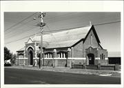
13 Glebe St North Perth
Cnr Glebe & View St
Vincent
Metropolitan
Constructed from 1915 to 1954
| Type | Status | Date | Documents |
|---|---|---|---|
| Heritage List | Adopted |
| Type | Status | Date | Documents |
|---|---|---|---|
| RHP - To be assessed | Current | 30 Jul 2004 |
| Type | Status | Date | Grading/Management | |
|---|---|---|---|---|
| Category | ||||
| Anglican Church Inventory | YES | 31 Jul 1996 | ||
| Municipal Inventory | Adopted | 13 Nov 1995 | Category B | |
· The place is a good example of a Federation Free Style architectural style church in the Town of Vincent.
· The place has historical value as it houses the oldest font in Australia, of Anglo Saxon origin.
· The place is associated with Archbishop Riley and his son Tom and William Loton.
‘St Hilda’s church is a robustly designed parish church with a gable front to View Street and a hipped southern end following the line of the semi octagonal sanctuary, buttressed walls and entrance porch in brick and stone. The porch has stone quoins, a shallow pointed arch entrance and a simple triangular pediment, featuring a cross decoration in the stucco. The porch extends to the footpath. The stonework continues as a wide band around the building. The windows also feature stone surrounds. The church has internal aisles for the length of the nave, which terminate before the sanctuary. The end wall of the sanctuary is solid with an inset stone cross and foundation stone, while the other walls have lancet windows with stained glass in lead lights.’
‘In about 1900, the first Anglican Sunday School and service for the parish known as All Saints Woodville were held at the home of Mrs Hahn on the corner of Olive and View Street. A wooden building transported form Canning Mills, and erected on the corner of Rose (Glebe street) and View Street in 1904, was consecrated as St Hilda’s North Perth. A church building fund was implemented in 1910. In 1914, Rev CL Riley, son of archbishop Riley, was appointed rector of St Hilda’s. He lived with his parents at Bishops House, traveling to his parish by motor bike. The foundation stone for St Hilda’s church was laid on 24th July 1915, by William T Loton, MLA and the church was consecrated on 10th October that year by Archbishop Riley. The rectory was also completed in 1915 and Rev Riley moved in.’ ‘In 1954, St Hilda’s Church was completed with the addition of the entrance porch, chancery, sanctuary, choir and vestries. The additions were consecrated on 12th December 1954 by Archbishop Moline. In 1974, the site of the original weatherboard church and the land occupied by the tennis courts were sold. A house was purchased on Coolbidin for use as a rectory and the original rectory was demolished. A parish centre was built on site. St Hilda’s boasts the oldest font in Australia. It is Anglo Saxon workmanship and dates from the 9th or 10th century. It was transferred to St Hilda’s when St john’s Anglican Church in Milligan Street was demolished in 1928.’
Integrity- High Authenticity- Moderate
Good
| Name | Type | Year From | Year To |
|---|---|---|---|
| George Herbert Parry | Architect | - | - |
Individual Building or Group
| Epoch | General | Specific |
|---|---|---|
| Present Use | RELIGIOUS | Church, Cathedral or Chapel |
| Original Use | RELIGIOUS | Church, Cathedral or Chapel |
| Style |
|---|
| Inter-War Romanesque |
| Type | General | Specific |
|---|---|---|
| Wall | BRICK | Common Brick |
| Wall | STONE | Limestone |
| Roof | METAL | Corrugated Iron |
| General | Specific |
|---|---|
| SOCIAL & CIVIC ACTIVITIES | Religion |
This information is provided voluntarily as a public service. The information provided is made available in good faith and is derived from sources believed to be reliable and accurate. However, the information is provided solely on the basis that readers will be responsible for making their own assessment of the matters discussed herein and are advised to verify all relevant representations, statements and information.
Constructed from 1915 to 1954
St Hilda’s Church at 13 Glebe Street is an exemplar of the comparatively rare Interwar Romanesque style. It houses the oldest font in Australia, of Anglo Saxon origin, it was moved to St Hilda’s when St John’s Anglican Church in Milligan Street was demolished in 1928. The Church has associations with Archbishop Riley and his son Tom, and William Loton.
St Hilda's Anglican Church is a robustly designed parish church with a gable front to View Street and a hipped southern end following the line of the semi-octagonal sanctuary, buttressed walls and entrance porch in brick and stone. The porch has stone quoins, a shallow pointed arch entrance and a simple triangular pediment, featuring a cross decoration in the stucco. The porch extends to the footpath. The stonework continues as a wide band around the building. The windows also feature stone surrounds. The church has internal aisles for the length of the nave, which terminate before the sanctuary. The end wall of the sanctuary is solid with an inset stone cross and foundation stone, while the other walls have lancet windows with stained glass set in leadlights.
Glebe Street was known as Rose Street until 1927 when the name was changed because the Anglican Church (then known as the Church of England) owned much of the land. In about 1900, the first Anglican Sunday School and services for the parish known as All Saints Woodville were held at the home of Mrs Hahn on the corner of Olive and View Streets, North Perth. Reverend John Alles of St Paul's Church in Carr Street, West Perth took the first church services in GIBSON: Hall (corner of Daphne and Angove Streets) and in the North Perth State School. In 1904 a wooden building transported from Canning Mills, and erected on the corner of Rose (Glebe) and View Streets in 1904, was consecrated as St Hilda's North Perth. It was named after St Hilda of Whitby (Yorkshire, UK) a nun who died in 680. St Hilda founded a new monastery at Whitby, high on a hill overlooking the ocean, thre remains of which are still in existence. St Hilda's Anglican School for Girls in Mosman Park was also named after her and the school has friendship links with St Hilda's School in Whitby. Lay assistants helped Reverend Allas and other clergymen until 1909 when the first resident rector, Reverend Harold Merryweather was appointed. He boarded initially in a house on the corner of Fitzgerald Street and Grosvenor Road until September 1910 when he moved to St Paul's rectory. A church building fund was implemented in 1910 and the minutes of the Vestry meeting on 16 June stated that 'Mr Prior moved and seconded by Mr Barnes that the sum of 12 pounds by paid into the government Savings Bank as a nucleus of the Church Building Fund'. In 1914, Rev C. L. (Tom) Riley, son of Archbishop Riley, was appointed rector of St Hilda's. Initially he lived with his parents at Bishop House, traveling to his parish by motor bike. The foundation stone for St Hilda's Church was laid on 24 July 1915, by William T. Loton, MLA, and the church was consecrated on 10 October that year by the Reverend's father, Archbishop Riley. The rectory was also completed in 1915, and Reverend Riley moved in. It was later the birthplace of his son, Reverend Canon L.W Riley. In 1919 Wise's Post Office Directories listed Reverend R. Coverdale as the resident clergyman at No. 19 Glebe Street. This was due to 'Tom' Riley's overseas service as a Chaplain in the 10th Light Horse during World War 1. In 1920 it was Reverend Riley again. In 1922 Reverend Joshua Williams took over and by 1927 the incumbent was Reverend William Patrick. The Montessori High School operated (possibly in the club rooms) for a few years from 1923 onwards under principal, Mrs A McNamara and in 1936 the Glebe View Tennis Courts were constructed. By 1940 Reverend Patrick had become Canon Patrick and he was still there in 1949, the last year the Directories were printed. In 1954, St Hilda's Church was completed with the addition of the entrance porch, chancel, sanctuary, choir and priest vestries. The additions were consecrated on 12 December 1954 by Archbishop Robert Moline. In 1974, the site of the original weatherboard church and the land occupied by the tennis courts were sold and part of the proceeds was used to finally pay off the 1954 additions. A house was purchased in Coolbinia for use as a rectory and the original rectory was demolished. A parish centre was built on the site. St Hilda's boasts the oldest font in Australia. It is of Anglo-Saxon workmanship and dates from the 9th or 10th Century and Reverend William Patrick arranged for it to be transferred to St Hilda's when St John's Anglican Church in Milligan Street was demolished in 1928. In 1975 the year of the church's diamond jubilee there were plans to erect a Parish Centre, which it was hoped would be a fitting memorial to the original church. The laneway at the rear of this is owned by the church but is open for public use. In 2003 - the year of the child - the husband and wife team of Reverends Sue and John Meagher introduced a 'tot church', a servie for under fives during which they were encouraged to sing, play and instrument or dance in the aisles. A 'blessing of the animals' was also held annually, which commemorates the life of St Francis of Assisi and locals were encouraged to take along their pets. Reverend Shane Hubner, a Anglican Minister from Queensland was appointed as the Rector in November 2004 and in 2008 he was still in residence. It remains in the Perth Diocese.
This information is provided voluntarily as a public service. The information provided is made available in good faith and is derived from sources believed to be reliable and accurate. However, the information is provided solely on the basis that readers will be responsible for making their own assessment of the matters discussed herein and are advised to verify all relevant representations, statements and information.
3 Glebe St North Perth
Vincent
Metropolitan
Constructed from 1910
| Type | Status | Date | Documents |
|---|---|---|---|
| Heritage List | Adopted |
| Type | Status | Date | Documents |
|---|---|---|---|
| (no listings) |
| Type | Status | Date | Grading/Management | |
|---|---|---|---|---|
| Category | ||||
| Municipal Inventory | Adopted | 12 Sep 2006 | Category B | |
Individual Building or Group
| Epoch | General | Specific |
|---|---|---|
| Original Use | RESIDENTIAL | Single storey residence |
| Present Use | RESIDENTIAL | Single storey residence |
| Style |
|---|
| Federation Queen Anne |
| Type | General | Specific |
|---|---|---|
| Other | RENDER | Roughcast |
| Wall | BRICK | Rendered Brick |
| Other | TIMBER | Other Timber |
| Wall | BRICK | Face Brick |
| Roof | METAL | Corrugated Iron |
| General | Specific |
|---|---|
| DEMOGRAPHIC SETTLEMENT & MOBILITY | Land allocation & subdivision |
This information is provided voluntarily as a public service. The information provided is made available in good faith and is derived from sources believed to be reliable and accurate. However, the information is provided solely on the basis that readers will be responsible for making their own assessment of the matters discussed herein and are advised to verify all relevant representations, statements and information.
Constructed from 1910 to 1914
The house, at 3 Glebe Street, is a fine and representative example of a Federation Queen Anne bungalow, which retains a high level of integrity. Glebe Street recalls the former glebe of St Hilda’s Anglican Church.
The single storey brick dwelling has a gambrel hipped roof with a dominant front gable with a bay window and bullnose front verandah. The gable is richly detailed with roughcast and decorative curved battens and patterns. The bay window is a three casement formation with fanlights under a richly molded arch. The front brick walls are tuckpointed and horizontal rendered bands are at window sill and head heights. The central front door, under the verandah has sidelights and a fanlight. The window under the verandah is a double hung sash. The verandah is supported by turned posts with decorative brackets and a turned vertical valence detail. The face brick chimney is detailed with stucco and has double clay pots. set back from the street behind a timber picket fence None apparent
Glebe Street and the surrounding area, was part of the residential subdivision in North Perth developed on Swan Locations 647 and 653 for private sale by 'land estate, mining and general agents' Solomon Hermann and Thomas Whitton Williams of Hay Street Perth in the 1890s. The releases of land were known variously as the Woodville, Percy, Toorak and Christmas Hill Estates. They were advertised as being 'close to the city boundary' and 'high and healthy'. The terms were one quarter cash and with the balance to be paid at 3, 6, 9 and 12 months without interest. Glebe Street, a short street that runs north-south between View Street and Alma Road was originally named Rose Street. The name was changed in 1927 to reflect the fact that some of the land had originally been part of the glebe (land owned by a parish church) of St Hilda's Anglican Church (then known as the Church of England), situated on the corner of View Street, which was consecrated in 1904. A letter dated 2 March 1927 from the City of Perth Council Chambers and Municipal Offices to the Secretary for Lands also mentioned the reason in support of the application to change the name of Rose Street to Glebe Street in North Perth, the letter stated, 'I beg to advise that this resolution was passed by the Council as the result of a petition of residents in Rose Street, who complained that Rose Street was confused with Roe Street.' A letter from the Department of Lands and Surveys indicates that approval was given to the change of name of Rose Street to Glebe Street in the City of Perth in 1927. However, Glebe Street was actually still listed in the Wise's Post Office Directories under "Rose" until 1930. The archival North Perth (Central Ward) Rate Books, in conjunction with the Post Office Directories, suggest that the subject lot, which is listed as Lot 32, Rose Road at the time, was a vacant land block between 1908 and 1910. The land was owned by Mrs M Sommers between 1909 and 1910. Adolphus G Sommers moved into the house in 1913 as the first occupier. The above information implies that the construction of the existing dwelling at No. 3 Glebe Street completed c1912 and the first occupier moved into the house in 1913. In 1914-1917, Horace L Wilmshurst became the occupier of the dwelling, during this period, the ownership of the land changed to Alfred Briggs in 1915. Following this, Mark Mendelanitz had a short stay at the dwelling in 1918 and then Mrs D S Hamilton lived in the house between 1919 and 1922. In 1923, Edward Green occupied No. 3 Glebe Street and his name was listed until 1939. Mrs Alice Gree, who may have been the widow of Edward Green, and John G Green, were listed in the Directories from 1940 to 1947, which indicates that the Green family lived there over twenty years. In 1949, the last of year of the Directories, the resident was PA Holywell.
restored to a high level of integrity
This information is provided voluntarily as a public service. The information provided is made available in good faith and is derived from sources believed to be reliable and accurate. However, the information is provided solely on the basis that readers will be responsible for making their own assessment of the matters discussed herein and are advised to verify all relevant representations, statements and information.
188 Grosvenor Rd North Perth
Vincent
Metropolitan
Constructed from 1909
| Type | Status | Date | Documents |
|---|---|---|---|
| Heritage List | Adopted |
| Type | Status | Date | Documents |
|---|---|---|---|
| (no listings) |
| Type | Status | Date | Grading/Management | |
|---|---|---|---|---|
| Category | ||||
| Municipal Inventory | Adopted | 12 Sep 2006 | Category B | |
Individual Building or Group
| Epoch | General | Specific |
|---|---|---|
| Present Use | RESIDENTIAL | Single storey residence |
| Original Use | RESIDENTIAL | Single storey residence |
| Style |
|---|
| Federation Queen Anne |
| Type | General | Specific |
|---|---|---|
| Wall | BRICK | Face Brick |
| Other | TIMBER | Other Timber |
| Roof | METAL | Corrugated Iron |
This information is provided voluntarily as a public service. The information provided is made available in good faith and is derived from sources believed to be reliable and accurate. However, the information is provided solely on the basis that readers will be responsible for making their own assessment of the matters discussed herein and are advised to verify all relevant representations, statements and information.
Constructed from 1908
No. 188 Grosvenor has heritage value as an examplar of the Federation Queen Anne Bungalow style and its long association with Mr Wilford Mitchell, prominent auctioneer and and property valuer.
The single storey brick and iron dwelling at No. 188 Grosvenor Road, North Perth was constructed circa 1909 in the Federation Queen Anne Style. The dwelling is positioned over two lots and has landscaped gardens. The dwelling has a two room street frontage and a recessed side entrance. The main roof from is hipped with various gable and hipped protrusions along its eastern elevation. One protruding gable is positioned diagonally to face the south east corner of the site. The gable ends are detailed with timber battens. An iron verandah runs the length of the southern and a portion of the eastern sides of the dwelling. The verandah is supported by turned timber posts and has decorative timber brackets and a timber valance. The dwelling has tuck-pointed brick walls with two sting courses. The southern elevation of the dwelling features three timber framed sash windows with decorative plaster sill detail. An interesting feature along the dwelling's eastern elevation is a small protruding room, which is capped by crenellations. The dwelling is located along the portion of Grosvenor Street between Leake and Fitzgerald Streets in North Perth. Constructed over two lots the dwelling is setback approximately 4.5 metres from its front boundary. A brick and iron fence separates the dwelling from the street. There is a row of Agapanthus and lawn within the front setback.
North Perth was initially called Woodville and Toorak after early estates in the area. It was not until March 1899 that is was officially named after the North Perth Roads Board area. It was reclassified as the North Perth Municipality in October 1901. The area was seen as a good place to live as housing was relatively cheap, and it was in walking distance of the City. Access to the City was greatly improved with the advent of trams along Fitzgerald Street from 1900 onwards. There were no houses erected in Grosvenor Road west of Fitzgerald Street until 1907 when one is listed in Wise's Post Office Directories as being occupied by John Linton. In 1909 there were three listed: Lintons's and two others but no street numbers had been allocated. It was not until 1909 that the numbers were listed in the Wise's Post Office Directories. By that time there were seven houses in the street and this included No. 188. No. 188 was constructed on the northern side at the western end of Grosvenor Road circa 1909. At the rear is a right-of-way which was part of the original survey. Thses lanes are very common in the North Perth area as they are in many other of the older suburbs of Perth. Their original purpose was to provide a rear access to the blocks and to allow the Council's night cart tyo access to the householders 'dunnies' which were built along the boundary of their properties. Initially these night carts were horse-drawn but they were later replaced by motorised vehicles. This service was gradullay phased out in the 1950's as more and more properties in the area were sewered. The first resident and owner of the place was Mr Wilford W Mitchell. Mitchell, who had a business in Viking House in William Street from 1907, Mitchell and Co Limited: auctioneer, house, land and estate agents, sworn valuators, resided at this dwelling from the time he purchased the property around 1908 until 1946. Wise's Post Office Directories indicate that from 1947 until at least 1949, Mrs Ruby Miller resided at the house.
High
This information is provided voluntarily as a public service. The information provided is made available in good faith and is derived from sources believed to be reliable and accurate. However, the information is provided solely on the basis that readers will be responsible for making their own assessment of the matters discussed herein and are advised to verify all relevant representations, statements and information.
30 Kayle St North Perth
Cnr Emmerson St
Smith's Lake Indoor Sports Hall
Vincent
Metropolitan
Constructed from 1969
| Type | Status | Date | Documents |
|---|---|---|---|
| (no listings) |
| Type | Status | Date | Documents |
|---|---|---|---|
| RHP - Does not warrant assessment | Current | 06 Jun 2008 |
| Type | Status | Date | Grading/Management | |
|---|---|---|---|---|
| Category | ||||
| (no listings) | ||||
| Name | Type | Year From | Year To |
|---|---|---|---|
| City of Perth Architectual Division | Architect | - | - |
| M J Boyce | Architect | - | - |
Individual Building or Group
| Epoch | General | Specific |
|---|---|---|
| Original Use | SOCIAL\RECREATIONAL | Other Sports Building |
| Present Use | SOCIAL\RECREATIONAL | Other Sports Building |
| Other Use | PARK\RESERVE | Park\Reserve |
| Type | General | Specific |
|---|---|---|
| Wall | CONCRETE | Concrete Block |
| General | Specific |
|---|---|
| SOCIAL & CIVIC ACTIVITIES | Sport, recreation & entertainment |
This information is provided voluntarily as a public service. The information provided is made available in good faith and is derived from sources believed to be reliable and accurate. However, the information is provided solely on the basis that readers will be responsible for making their own assessment of the matters discussed herein and are advised to verify all relevant representations, statements and information.
31 Kayle St North Perth
Cnr Smith's Lake Cnr Bourke St Assessed as part of P17293 Len Fletcher Pavilion and Smith's Lake
Vincent
Metropolitan
Constructed from 1950
| Type | Status | Date | Documents |
|---|---|---|---|
| Heritage List | Adopted |
| Type | Status | Date | Documents |
|---|---|---|---|
| RHP - Does not warrant assessment | Current | 06 Jun 2008 |
| Type | Status | Date | Grading/Management | |
|---|---|---|---|---|
| Category | ||||
| Municipal Inventory | Adopted | 13 Nov 1995 | Category A | |
17293 Len Fletcher Pavilion and Smith's Lake
Urban Park
| Epoch | General | Specific |
|---|---|---|
| Present Use | PARK\RESERVE | Park\Reserve |
| Original Use | PARK\RESERVE | Park\Reserve |
| Type | General | Specific |
|---|---|---|
| Other | CONCRETE | Other Concrete |
| General | Specific |
|---|---|
| DEMOGRAPHIC SETTLEMENT & MOBILITY | Settlements |
This information is provided voluntarily as a public service. The information provided is made available in good faith and is derived from sources believed to be reliable and accurate. However, the information is provided solely on the basis that readers will be responsible for making their own assessment of the matters discussed herein and are advised to verify all relevant representations, statements and information.
Constructed from 1955 to 1965
The public open space is a former wetland, previously used for market gardening, farming and as a rubbish tip, which was rehabilitated for active and passive recreational purposes, with integrated open drainage water courses, in both Postwar Arcadian and Functional styles.
The public open space, with its associated Smith's Lake Drainage Reserve and Charles Veryard oval and changing rooms (see separate place record form), is the product of an extensive rehabilitation project undertaken by the Perth City Council during the 1960s. The rehabilitation transformed the former wetland, used for market gardening and farming (see Browne's Dairies place data form, 299-317 Charles Street), then as a rubbish tip, particularly during the Second World War. The drainage reserve is a reminder of its former role as a wetland as well as a functional element of the public open space. The landscaping is functional in the active recreational areas, with grassed areas and selected tree plantings, and arcadian in the passive recreational areas, with its simple palette of grass, shrubs, informal tree plantings and simplefunctional built elements.
Smith's Lake was known to Aboriginals as Danjanberup. Farming, market gardening and dairying were carrried out around its edge following European settlement in 1829. It originally covered a larger area then it does today but in the 1920's the Claisebrook drain extended there and the amount of surface water decreased. Between 1914 and 1937, the City of Perth much of the former lake areas north of Perth for the redvelopment as parks and recreation areas. However, Smith's Lake was the last to be fuly developed. It remained as 'swamp land and high reeds' (Harold Lee) and hte area was still being used for market gardening in the 1950's. John Gooey had a house and market garden on the edge of the lake and south of his was another. There was als one where Barnett Place is now and a fourth in nearby Howlett behind a house on Loftus Street. George Gooey, one of John's sons, ran a vegetable delivery round and local schoolboys often helped him on Sundays. The vegetables were carried in a four - wheeled canvas covered cart which was horse drawn. The lake itself was used as a rubbish tip, and after the Second World War it contained the remains of rusting wartime tanks and Bren - gun carriers. John Gooey's land was resumed by the Perth City Council in 1959 and the area around Smith's Lake was subject to a planning scheme in the 1960's. The Perth City Council wanted to provide a swimming pool. cultural centre, kindergarten and infant welfare centre on the land but that plan proved too costly. Insetead, the lake was filled again bu dumping rubbish there and it was subdivided, creating 76 residentail and 10 commercial lots as well as the recreational reserve. Teh Charles Veryard Reserve (53 and 55 Albert Street) was named after Perth City Councillor from 1927 to 1964 and Mayor of Perth from 1964 until his death in 1967. It became the home of the North Perth Cricket Club and Old Modernians Hockey Club with facilities, such as the change rooms and socal rooms, established for their use. A Smith's Lake Precinct Group was formed in 1997 and rehabilitation of the lake began in 1999 through the efforts of this group. They were assisted by corporate and local government funding and helop with the replanting came form the wider community, including the North Perth Primary School children. Further subdivision occured in 2000 when the Vincent Council's former Works Depot in Richmond Street was subdivided (the depot relcoated to Osborne Park the same year). In 2002 further work was carried out on the area, changing it back to a more natural setting, and art works were added plus recordings of interviews from the Vincent Local History Centre. This work was the first stage of the development of a Wetlands trail linking all the wetlands in the Vincent area with Banks Reserve on the river in Mount Lawley. Land in Smith Street (now Emmerson) and adjoining the drainage reserve on the west side was offered for 20 pounds a block sometime at the beginning of the 20th century in whicih was known as the Lakeside Estate. This land was surveyed by Bellingham & Co of St George's Terrace, Perth and sold by Chas Sommers in conjuction witih F.W.B Clinch. While it appeared as Smith Street on the early subdivision map, by 1915 the first year it was listed in Wise's Post Office Directories, it was called Bent Street. The following year, 1916 it was listed as Emmerson Street as it is today. The area of Smith's Lake was subject to a planning scheme in the 1960s. The edges of the lake bed had been used for farming and market gardening, while the lake itself had become a rubbish tip and contained the remains of rusting wartime tanks and Bren-gun carriers. Perth City Council had the lake bed filled and a subdivision was developed comprising residential lots, commercial/communal lots and a recreation reserve on the north side of Bourke Street. An area of the reclaimed lake south of Bourke Street remained as open space with residential development on all sides. The lake drain runs through this area and a small remnant of lake acts as a drainage catchment.
Moderate to High
This information is provided voluntarily as a public service. The information provided is made available in good faith and is derived from sources believed to be reliable and accurate. However, the information is provided solely on the basis that readers will be responsible for making their own assessment of the matters discussed herein and are advised to verify all relevant representations, statements and information.
11 Knutsford St North Perth
Vincent
Metropolitan
Constructed from 1905
| Type | Status | Date | Documents |
|---|---|---|---|
| Heritage List | Adopted |
| Type | Status | Date | Documents |
|---|---|---|---|
| (no listings) |
| Type | Status | Date | Grading/Management | |
|---|---|---|---|---|
| Category | ||||
| Municipal Inventory | Adopted | 22 Dec 1995 | Category B | |
Individual Building or Group
| Epoch | General | Specific |
|---|---|---|
| Present Use | RESIDENTIAL | Single storey residence |
| Original Use | RESIDENTIAL | Single storey residence |
| Style |
|---|
| Federation Queen Anne |
| Type | General | Specific |
|---|---|---|
| Wall | TIMBER | Weatherboard |
| Other | TIMBER | Other Timber |
| Roof | METAL | Corrugated Iron |
| General | Specific |
|---|---|
| DEMOGRAPHIC SETTLEMENT & MOBILITY | Settlements |
This information is provided voluntarily as a public service. The information provided is made available in good faith and is derived from sources believed to be reliable and accurate. However, the information is provided solely on the basis that readers will be responsible for making their own assessment of the matters discussed herein and are advised to verify all relevant representations, statements and information.
Constructed from 1905 to 1930
The house at No. 11 Knutsford Street is a fine and delightful example of the Federation Queen Anne style, constructed in weatherboard, that has been refurbished to a high level of integrity.
The house is constructed of weatherboard, painted, with a predominantly hipped roof with gambrel roof ventilators. The symmetrical frontage is given emphasis by the decorative gablets above the symmetrical window bays to each of the front rooms. The separate skillion verandah is supported by six turned timber posts, with brackets supporting a decorative fretwork valence. The five bays of the verandah emphasise the central front door and align with the geometry of the bay windows. One chimney survives aligned with the right hand gable. A street facing house with a narrow front garden, fully developed in a cottage style, behind a replacement timber and picket front fence.
Knutsford Street was originally part of a separate subdivision, almost a triangular shape of some 127 larger lots (now mostly subdivided), bounded by Norham, Namur, Walcott and Blake streets. The cross streets were imaginatively named First Avenue (changed to Namur Street in 1916), Second Avenue (changed to Ruby Street in 1904), Third Avenue (changed to Mabel Street in 1904) and Fourth Avenue (changed to Blake Street in 1916). The narrow laneways in between named No 1, No 2 and No 3 Street. Two of these have since been renamed Nova Lane (between Ruby and Mabel Streets) and Fiore Lane (between Ruby and Namur Streets). The area was known as Woodville initially and in 1899 it was offically designaged as North Perth with the formation of a local roads board (North Perth Roads Board) and in October 1901, it was reclassified as the North Perth Municipality. No. 11 is a weatherboard house according to the MWSSDD sewerage plans of the 1930s. Most of the approximately 20 houses in the street at this time were of weatherboard construction and there were only a few vacant lots. The lot for No. 11 was created by subdividing Lots 47 and 48 of the original subdivision into three. No. 11 ocupied the centre of the centre of these three lots. There were no houses listed for the street in the Wise's Post Office Directories from 1903 (when the street was first listed) until 1905. In 1906 there were two listed and six were listed for 1915. In 1916 street numbers were introduced for the first time but not for all the houses in the street. No. 11 was listed and its occupant at that time was John G. Drake. By this time there were 14 houses in the street but this was the first time his name had appeared on the list. In 1930 No. 11 was occupied by George Henry Jennings and in 1949, the last year of the Directories, by Mrs Mary Crawley. One of the attractions of Knutsford Street was Woodville Reserve at its southern end. As early as 1910 the North Perth Bowling Club was established there and the tennis courts followed in 1915, and the Woodville Cricket Club in 192. The park is still used for tennis, lawn bowls and cricket and soccer and volleyball are also currently played there (2008). The part is also a dog exercise area and there is playground equipment, barbecues, public toilets and a pavilion, where groups such as the Swiss Club meet on a regular basis. The subject place has been delighfully restored in recent years.
Moderate to High
This information is provided voluntarily as a public service. The information provided is made available in good faith and is derived from sources believed to be reliable and accurate. However, the information is provided solely on the basis that readers will be responsible for making their own assessment of the matters discussed herein and are advised to verify all relevant representations, statements and information.
73 Lawler St North Perth
Vincent
Metropolitan
| Type | Status | Date | Documents |
|---|---|---|---|
| (no listings) |
| Type | Status | Date | Documents |
|---|---|---|---|
| RHP - Does not warrant assessment | Current | 28 Sep 2018 |
| Type | Status | Date | Grading/Management | |
|---|---|---|---|---|
| Category | ||||
| (no listings) | ||||
• The place has some aesthetic value as a modest Inter-War Californian Bungalow style residence, with classic stylistic elements such as its timber gabled front porch.
• The place has some historic value for its association with the well-known Western Australian construction company Plunkett Building & Investment Company.
Single-storey two-bedroom brick residence with enclosed sleepout. Original bathroom and kitchen. Leadlight windows in lounge. Timber floorboards in kitchen.
The residence is thought to have been constructed in late 1938. In 1938, the land was owned by the Western Australian construction company Plunkett Building & Investment Company. Established in 1903, by carpenter Thomas Scott Plunkett, the Plunkett building company was responsible for the construction of a large number of residences in North Perth, Mount Hawthorn, Claremont, Nedlands, Melville and Woodlands in the 1920s and 1930s. Post World War II, the company built many houses for the Workers Homes Board and War Service Homes Board. By the 1950s, the company had established its own timber mills, joinery and brickworks and was capable of building an estimated 1,000 houses per year.
Fair
Individual Building or Group
This information is provided voluntarily as a public service. The information provided is made available in good faith and is derived from sources believed to be reliable and accurate. However, the information is provided solely on the basis that readers will be responsible for making their own assessment of the matters discussed herein and are advised to verify all relevant representations, statements and information.
1, 3 & 7 Leake St North Perth
Vincent
Metropolitan
| Type | Status | Date | Documents |
|---|---|---|---|
| Heritage List | Adopted |
| Type | Status | Date | Documents |
|---|---|---|---|
| (no listings) |
| Type | Status | Date | Grading/Management | |
|---|---|---|---|---|
| Category | ||||
| Municipal Inventory | Adopted | 12 Sep 2006 | Category B | |
Individual Building or Group
| Epoch | General | Specific |
|---|---|---|
| Present Use | RESIDENTIAL | Single storey residence |
| Original Use | RESIDENTIAL | Single storey residence |
| Style |
|---|
| Federation Queen Anne |
| Type | General | Specific |
|---|---|---|
| Other | TIMBER | Other Timber |
| Roof | METAL | Corrugated Iron |
| Wall | BRICK | Rendered Brick |
| Roof | TILE | Ceramic Tile |
| Wall | BRICK | Face Brick |
| General | Specific |
|---|---|
| SOCIAL & CIVIC ACTIVITIES | Religion |
This information is provided voluntarily as a public service. The information provided is made available in good faith and is derived from sources believed to be reliable and accurate. However, the information is provided solely on the basis that readers will be responsible for making their own assessment of the matters discussed herein and are advised to verify all relevant representations, statements and information.
Constructed from 1910 to 1920
The bungalows, at 1,3 & 7 Leake street are three fine examples of their style and period with 1 and 7 being representative and, perhaps, exemplars of the Federation Queen Anne style. The cohesive group demonstrates substantial middle class dwellings of the period, in the Monastery Grounds Estate
The three dwellings are fine examples of their style and period. All are assymmetrical in form with expansive hipped roofs and one or more gable features. The places all have corner verandahs, both separate and integral roofs. The places are all brick structures and feature decorative valances, fretwork brackets and turned timber posts. 1 & 7 have the characteristic richness of detail associated with the Queen Anne style, whilst 3 is much plainer in detail consistent with the character of the Bungalow style. The projecting verandah eaves of 3 shadow the valence detail and weaken the visual junction of the roof and its supporting structure. Low brick fences reveal the lawn and garden residential settings None apparent
The west side of Leake (originally John) Street was part of the Monastery Grounds Estate, which covered the area between Leake (west side) and Camelia Street (east side) and was bounded by Park Street on the north side and Vincent Street to the south. The Estate was established following the construction of the Redemptorist Monastery in 1903, at which time the excess church land was subdivided for residential use. The estate was advertised as being 'situated on the heights of North Perth' and 'only one mile from the Central Railway Station'. In the early 20th Century people were used to walking and a one-mile walk into the City was considered very reasonable. Besides, as the advertisement went on to say, it was 'only one minute from the tram', which ran along Charles Street. The agent, W. Wilford Mitchell of 83 William Street, Perth, also boasted that the blocks were 'surrounded by superior villas, overlooking City and river'. The houses at 1, 3 and 7 Leake Street appear to be the only houses in this section of the street on the MWSSDD sewerage plan but they were not numbered. Between 1911 and 1915 no houses were listed in this section of the street in Wise's Post Office Directiories. In 1915 the name was changed to Leake Street and Nos 1 and 7 were listed with Harry Highman at No. 11 and Mrs P.J. Horrigan at No. 7. No. 3 was listed for the first time in 1919 when Mrs Harry Throssell was the resident. At that time the other occupants were still Harry Highman (No.1) and Michael J. Horrigan at No. 7. According to the City of Perth rate books, in 1922 the houses were owned by Henry Highman (No. 1), Miss Rosetta Smith (No. 3) and Priscilla Horrigan (No. 7) which was described as 'house & ground'. The capital value for the latter was given as ₤1,250 whereas Nos 1 and 3 were valued at ₤900. Nos 1 and 3 were rentals at that stage but the owner Priscilla Horrigan occupied No. 7. In 1949, the last year of the Directories, the residents were John M. Woulfe and Norm Waggs (No.1), Miss Rosetta Smith (No.3) and Mrs Priscilla J. Horrigan and Mrs D. Croft (No. 7). Additions/alterations were carried out to No. 1 in 2006 by Dale Alcock Home Improvements.
High degree
This information is provided voluntarily as a public service. The information provided is made available in good faith and is derived from sources believed to be reliable and accurate. However, the information is provided solely on the basis that readers will be responsible for making their own assessment of the matters discussed herein and are advised to verify all relevant representations, statements and information.
Lincoln, Wright & Lord Sts North Perth
Nos, 2,4,6,10,16,24,32,36,44,50,52,54,56,58,60,62,64,66 41 Wright St, Cnr Lincoln 301 & 303 Lord Street
Vincent
Metropolitan
Constructed from 1898 to 1983
| Type | Status | Date | Documents |
|---|---|---|---|
| (no listings) |
| Type | Status | Date | Documents |
|---|---|---|---|
| RHP - Does not warrant assessment | Current | 28 Feb 2014 |
| Type | Status | Date | Grading/Management | |
|---|---|---|---|---|
| Category | ||||
| (no listings) | ||||
Relatively intact collection of residences
Precinct or Streetscape
| Epoch | General | Specific |
|---|---|---|
| Original Use | RESIDENTIAL | Single storey residence |
| Present Use | RESIDENTIAL | Single storey residence |
| Style |
|---|
| Victorian Georgian |
| Type | General | Specific |
|---|---|---|
| Wall | BRICK | Common Brick |
| Roof | METAL | Corrugated Iron |
This information is provided voluntarily as a public service. The information provided is made available in good faith and is derived from sources believed to be reliable and accurate. However, the information is provided solely on the basis that readers will be responsible for making their own assessment of the matters discussed herein and are advised to verify all relevant representations, statements and information.
8 Macedonia Pl North Perth
Vincent
Metropolitan
Constructed from 1976
| Type | Status | Date | Documents |
|---|---|---|---|
| Heritage List | Adopted |
| Type | Status | Date | Documents |
|---|---|---|---|
| (no listings) |
| Type | Status | Date | Grading/Management | |
|---|---|---|---|---|
| Category | ||||
| Municipal Inventory | Adopted | 12 Sep 2006 | Category B | |
Individual Building or Group
| Epoch | General | Specific |
|---|---|---|
| Original Use | RELIGIOUS | Church, Cathedral or Chapel |
| Present Use | RELIGIOUS | Church, Cathedral or Chapel |
| Present Use | RELIGIOUS | Other |
| Style |
|---|
| Late 20th-Century Imgnts Nostalgic |
| Type | General | Specific |
|---|---|---|
| Wall | RENDER | Other Render |
| Wall | BRICK | Face Brick |
| Roof | TILE | Other Tile |
| General | Specific |
|---|---|
| SOCIAL & CIVIC ACTIVITIES | Religion |
This information is provided voluntarily as a public service. The information provided is made available in good faith and is derived from sources believed to be reliable and accurate. However, the information is provided solely on the basis that readers will be responsible for making their own assessment of the matters discussed herein and are advised to verify all relevant representations, statements and information.
Constructed from 1976
St Nikola Macedonian Orthodox Church & Macedonian Welfare Centre is significant in demonstrating the multicultural community in the Town, which is a place of worship for the Macedonian community in a facility that is a contemporary expression of its traditional form.
The complex one and two storey structure is a brick building with render detailing. The roof is predominantly hipped, with facetted hips to the hexagonal towers, and a gable frontage to the street, behind a render topped brick parapet with a rounded render detail at the apex. The building features semi circular arches throughout, rendered molded detailing and classical columns. Brick pillars and wrought iron fence delineates the boundary. The verge and property are entirely brick paved with some trees planted between. None apparent
The first organised Macedonians began to arrive in Australia as early as 1920. They arrived in Australia with limited financial resources but worked hard to establish a home and future for their families. The first Macedonian Club in Perth was opened in William Street in 1926. It was referred to as Macedonian House. Other Macedonian Clubs were also opened in and around the area known today as Northbridge and became gathering places for all Macedonians. The clubs served as important bases for Macedonian people experiencing typical problems associated with settlement in a new homeland. The onset of WW11 resulted in an increasing flow of migrants into Australia. The endeavours of Perth based Macedonians keen to assist their newly arriving relatives and establish a significant a significant location for communication and support led to the formation of associations like 'Edinstvo' in 1941 which have played an ongoing and progressive role in providing financial, physical and social support to Macedonian migrants. The oppression and hardship emanating from the Grrek Civil War (1945-1948) saw many more Macedonians move to Australia to establish a better life whilst others were keen to re-unite with their families. Although the established settlers has purchased a hall in Leederville (1949), it was not long before the growing number of Macedonian migrants meant that a more substantial building was required to address the demands of a growing community. This proposition is supported by the fact a Women's Section was formed in 1948 for the specific purpose of establishing a Macedonian Community Centre. The Women's Secttion played an important role in helping to raise funds that contributed to the purchase of land in North Perth where the Community Centre now stands. The preliminary sketches for a comprehensive Community Centre were drawn in 1958 with the support of a Macedonian architect. The completion of these sketches coincided with a series of transactions that resulted in the purchase of property in Bourke Street, North Perth. By April 1959, he Western Australian Macedonian Community was fully committed to building a substantial home in Western Australia. In order to formalise their operations and provide a guiding framework for future plans, the Macedonian Community engaged in the preparation of a Constitution. At a general meeting of members in 1964, the Community's first Constitution was ratified and subsequently registered under the name 'Macedonian-Austtralia Community of Perth WA (Inc)'. The Constitution along with the plans to build the Community Centre, were testament to an every growing confidence, status and esteem among Macedonians and their ongoing struggle for recognition. Work on the construction of the Macedonian Cultural Centre at the corner of Albert and Kayle Street, North Perth (now Macedonian Place) began in February 1966. On 17 September 1966, an elaborate ceremonial blessing was conducted by Arch Priest, Metodi Gogov. Almost 1000 Macedonians from all over Australia attended to mark the occasion. The momentum and interest generated by this event led to requests being sent to the Macedonian Orthodox Church hierarchy for a parish priest to move to Perth. Father Gogov was duly appointed and commenced his work in September 1968 at the Anglican Church in North Perth. For the first time Western Australians Macedonians were able to attend services, baptise their children, get married and be buried under the authority of the Macedonian Orthodox Church. The opening of the Macedonian Centre and the adjoining temporary Church led to an expansion of the Community's cultural, spiritual and sporting activities. These events played an important role in promoting Macedonian consciousness and pride. However, the ongoing growth and developent of these activities led to significant demands being placed on the existing faciltities. The Macedonian Community responded by adding a second floor to the existing cultural centre in 1976. In November 1990, the Macedonian Community passed a resolution to build a new Macedonian Orthodox Church at No. 8 Macedonian Place across the road from the Community Centre. A consecration ceremony to officially launch the project occured in August 1994. Macedonian consultants were engaged in the design, engineering and building components of the construction process. The Macedonian Community also commissioned renowend iconographer, Stephan Adamache, to paint the walls and ceilings in accordance with the traditions of the Macedonian Orthodox Church. On 4 February 1996, the place of worship was blessed and officially opened by Metropolitan Bishop Petar. The ceremony involved Macedonians Australians from all parts of the country, dignitaries from Macedonia and Local, State and Federal politicians. A war memorial was also erected in the grounds of the Church to pay due respect to Macedonians who had given their lives in the pursuit of freedom and independence. Construction of this monument was led by the Macedonian Veterans Association in conjunction with the Macedonian Community. The war memorial was officially unveiled by Premier Gallop on 14 October 2001 and has served as a point of solemn reflection, recognition, rememberance and respect on occassions of national significance to both the Macedonian and broader Australian community.
High degree
This information is provided voluntarily as a public service. The information provided is made available in good faith and is derived from sources believed to be reliable and accurate. However, the information is provided solely on the basis that readers will be responsible for making their own assessment of the matters discussed herein and are advised to verify all relevant representations, statements and information.
3 Mignonette North Perth
City of Vincent
Vincent
Metropolitan
| Type | Status | Date | Documents |
|---|---|---|---|
| Heritage List | Adopted | 05 Mar 2019 |
| Type | Status | Date | Documents |
|---|---|---|---|
| (no listings) |
| Type | Status | Date | Grading/Management | |
|---|---|---|---|---|
| Category | ||||
| Municipal Inventory | Adopted | 05 Mar 2019 | Category B | |
Individual Building or Group
| Epoch | General | Specific |
|---|---|---|
| Present Use | RESIDENTIAL | Single storey residence |
This information is provided voluntarily as a public service. The information provided is made available in good faith and is derived from sources believed to be reliable and accurate. However, the information is provided solely on the basis that readers will be responsible for making their own assessment of the matters discussed herein and are advised to verify all relevant representations, statements and information.
Constructed from 1911 to 1912
The place is a tuck pointed red brick and corrugated metal roofed dwelling, constructed circa 1912. The place is representative of the Federation Bungalow style of dwelling, typical of much of the modest-scale residential development in North Perth constructed during the Federation period. The place has moderate aesthetic value as a good and intact example of the Federation Bungalow style. The place has moderate historic value as part of a pattern of suburban development in North Perth. It is one of the earliest dwellings constructed in phase one of the Christmas Hill estate, which was the second subdivision in North Perth. The existing outhouse is rare and possibly is the last house to have a toilet next to the right of way in the local area. This contributes to an understanding of the daily life in the early twentieth century when houses were not connected to the sewerage system
An external inspection was undertaken in October 2018 for the purpose of this assessment. Internal inspection was undertaken on 23 November 2018. The Post Office Directory indicates that the subject place was constructed circa 1912. The dwelling is designed in the Federation Bungalow style and constructed in tuck pointed red brick with corrugated metal roof. The place is a single storey symmetrical dwelling with a high-pitched hipped roof featuring twin gables above symmetrical sets of double vertical casement windows. A skillion verandah extends across the entire front façade and is supported by chamfered timber posts, spanned by lacework frieze and corner brackets. The front fence is decorative wrought iron. The chimneys are symmetrical tuck point brick with moulded top detail and the front facing gables are timber and stucco with decorative finials. More recently, alterations and additions were approved in 2016 which included an attic conversion to a habitable room including two south facing dormer windows. The additions have minimal impact to the heritage significance of the dwelling or the streetscape. The original brick outhouse, which is located at the back of the house and next to the back lane, is still existing. The facilities inside the room have all been previously removed. Whilst there is evidence that the original mortar has been eroded out and render fallen, the structure of the outhouse appears to be in good condition. The existing outhouse is rare and possibly is the last house to have a toilet next to the right of way in the local area. This contributes to an understanding of the daily life in the early twentieth century when houses were not connected to the sewerage system and people built an outhouse at the rear of their property.
Mignonette Street forms part of the first phase of the subdivision of North Perth known as Christmas Hill, which includes Mignonette, Magnolia and Pansy streets. The subject dwelling at No. 3 Mignonette Street first appeared on the WA Post Office Directories in 1913. The first resident was Oliver Cheney until 1915 when Alfred Lenneberg became the second occupant until 1919. Early occupancy of the place changed frequently comprising Oliver Parlington (1920), Noel Brady (1921 – 1925), Alan Mann (1926 – 1929), Alee Ashton (1930), Alan Mann (1931 – 1939), Jas Hofman (1940 – 1943), Fredrick Johnstone (1944 – 1949). There is limited information available which documents the ownership/occupancy of the subject dwelling after the Directories ceased its publication in 1949.
The place is not rare as Federation Bungalow is a common vernacular style of architecture in the local area and does not represent any aspect of cultural heritage of the City of Vincent that may be endangered. The place has moderate aesthetic value as a good and relatively intact example of the Federation Bungalow style. The place appears to be in good condition. The place holds a high degree of integrity by maintaining its original use as a residence. Overall, the place has a moderate degree of authenticity by maintaining a high level of its original features.
Good
This information is provided voluntarily as a public service. The information provided is made available in good faith and is derived from sources believed to be reliable and accurate. However, the information is provided solely on the basis that readers will be responsible for making their own assessment of the matters discussed herein and are advised to verify all relevant representations, statements and information.
62 Palmerston St North Perth
MI says 60-62 Palmerston St
Vincent
Metropolitan
Constructed from 1899
| Type | Status | Date | Documents |
|---|---|---|---|
| Heritage List | Adopted |
| Type | Status | Date | Documents |
|---|---|---|---|
| RHP - Does not warrant assessment | Current | 13 Feb 2004 |
| Type | Status | Date | Grading/Management | |
|---|---|---|---|---|
| Category | ||||
| Municipal Inventory | Adopted | 22 Dec 1997 | Category B | |
15858 Northbridge Precinct
Individual Building or Group
| Epoch | General | Specific |
|---|---|---|
| Original Use | RESIDENTIAL | Single storey residence |
| Present Use | RESIDENTIAL | Single storey residence |
| Style |
|---|
| Other Style |
| Type | General | Specific |
|---|---|---|
| Wall | BRICK | Face Brick |
| Roof | METAL | Corrugated Iron |
| Wall | BRICK | Painted Brick |
| Other | TIMBER | Other Timber |
| General | Specific |
|---|---|
| DEMOGRAPHIC SETTLEMENT & MOBILITY | Settlements |
This information is provided voluntarily as a public service. The information provided is made available in good faith and is derived from sources believed to be reliable and accurate. However, the information is provided solely on the basis that readers will be responsible for making their own assessment of the matters discussed herein and are advised to verify all relevant representations, statements and information.
Constructed from 1899
The semi-detached pair of dwellings at No 60-62 Palmerston Street are a fine example of Federation Cottages that contribute to the quality and diversity of Palmerston Street.
A semi detached pair of cottages with hipped roofs, central fireplaces, bullnose verandahs with decorative timber bressemer and a fire wall with vermiculated cap. One of the pair has retained its face brickwork, while the brickwork of the other has been painted. This is reflected in the brick piers of the front fence.
This section of Palmerston Street is situated in the area immediately north of Lake Henderson. Market gardening activities were carried out on the bed of Lake Henderson after it was drained in the early 1870s, and the surrounding areas developed early. European gardeners were followed by Chinese market gardeners who operated in the area until the early 1920s. Palmerston Street was named 1858 after Lord Palmerston (1784-1807), Prime Minister of England. He was an exponent of liberal politics and gunboard diplomacy and variously nicknamed 'Lord Cupid' and 'Lord Pumicestone'. It first appeared in Wise's Post Office Directories in 1893 when there were eight houses listed. In 1898 street numbers appeared but did not include Nos. 60 or 62. The subject place was within J.S Brooking's 'Brooking Park Estate' which was for sale in 1896. Exceptions Brooking's own home at 'Lakeside' and Edward Keane's 'Palmerston House' opposite at No. 12, both of these homes being constructed earlier on. The semi-detached pair at No 60-62 Palmerston Street first appeared in the City of Perth Rate Books in 1899. They were owned by Thomas Barker. No. 60 was occupied by Joseph Tippett, clerk, and No 62 by Mrs Caroline Bateson. Both these tenants were listed in the 1900 Directories. In 1906 there were both still owned by Barker and the occupants were No. 60 Lawrence Flynn (draper) and Walter W.Abbot (outfitter). In 1925 the occupants were Mrs A.W. Yews (No. 60) and Charles H. Stubbs (No. 62). In 1935 it was Mrs Constantine (No. 60) and Joseph Doody (No. 62) who was listed to 1940 and then his wife Ellen followed to 1949, the last year the Directories were published. The longest resident of this period at No. 60 was Mrs Ellen Morgan who was there from 1940 to at least 1949. In the early 1950s the immediate area around the subject property was not completely developed. Nos. 60-62 were one of the three groups of early semi-detached dwellings located in the area at that time and No. 62 was the more original of the two. No. 60 was advertised for sale in 2005 by which time it had been fully restored in the Federation Style but with many modern features, including air-conditioning. At this time it was described as 'charming' and a 'quaint, inner-city cottage.' The asking price was $440,000. No 62 is the more original of the two residences.
Moderate to High
This information is provided voluntarily as a public service. The information provided is made available in good faith and is derived from sources believed to be reliable and accurate. However, the information is provided solely on the basis that readers will be responsible for making their own assessment of the matters discussed herein and are advised to verify all relevant representations, statements and information.
131 Raglan Rd North Perth
MI notes address as 129-131 Raglan Road, North Perth
Bethany Indonesian Parish
St Margaret's Presbyterian Church
Vincent
Metropolitan
Constructed from 1905, Constructed from 1913
| Type | Status | Date | Documents |
|---|---|---|---|
| Heritage List | Adopted |
| Type | Status | Date | Documents |
|---|---|---|---|
| RHP - To be assessed | Current | 25 Nov 2011 |
| Type | Status | Date | Grading/Management | |
|---|---|---|---|---|
| Category | ||||
| Municipal Inventory | Adopted | 12 Sep 2006 | Category A | |
The place is a good example of a early twentieth century church, which was built and to meet the growing and changing needs of the local religious community.
The place is associated with the Indonesian Parish of North Perth.
The place was designed by architect John/James Hine.
The red brick church is constructed with horizontal cream render lines run through the front and sides of the building. The front and side windows are stained glass and are highlighted with cream stonework.
St Mary’s Presbyterian Church was constructed in 1913 to accommodate the growing Presbyterian community in the North Perth area. The Presbyterian Parish had held services in the North Perth Town Hall (part of P2216 North Perth Town Hall Complex) from 1903 and St Margaret’s Uniting Church (fmr) at 65-637 Raglan Road (RHP 2214) from 1905, but the congregation outgrew both these building by 1913 and the church employed architect John Hines1 to design a new premises. The new church was planned to accommodate 500 worshippers. The foundation stone was laid on 15 November 1913, with a ceremony performed by Rev. Prof. Adam DD.2 Although the church wasn’t completed, the parish started using the church by July 1914. In 1922, members of the church continued to increase, so a property a few streets away at 111 Forrest Street to be used as the parish Manse. In 1929 the Mary Henderson Primary Room was added to be used as a Sunday school room. In 1977 the Presbyterian Congregational and Methodist parishes amalgamated to form the Uniting Church. The church is now occupied by the Indonesian Parish of the Uniting Church.
| Name | Type | Year From | Year To |
|---|---|---|---|
| John Stroud Glaskin | Architect | - | - |
| John Hine | Architect | 1905 | - |
Individual Building or Group
| Epoch | General | Specific |
|---|---|---|
| Original Use | RELIGIOUS | Church, Cathedral or Chapel |
| Present Use | RELIGIOUS | Church, Cathedral or Chapel |
| Original Use | RELIGIOUS | Church Hall |
| Style |
|---|
| Federation Romanesque |
| Type | General | Specific |
|---|---|---|
| Roof | METAL | Corrugated Iron |
| Wall | BRICK | Face Brick |
| Wall | BRICK | Rendered Brick |
| General | Specific |
|---|---|
| SOCIAL & CIVIC ACTIVITIES | Cultural activities |
| SOCIAL & CIVIC ACTIVITIES | Religion |
This information is provided voluntarily as a public service. The information provided is made available in good faith and is derived from sources believed to be reliable and accurate. However, the information is provided solely on the basis that readers will be responsible for making their own assessment of the matters discussed herein and are advised to verify all relevant representations, statements and information.
Constructed from 1905 to 1929
Bethany is the former Uniting Church, at 129-131 Raglan Road. It is one of the finest examples of the Federation Romanesque style, to the design of well known architect John Hine. The place has earlier associations with the Presbyterian Church, the Uniting Church and, more recently, the Indonesian Parish of the Uniting Church illustrating the changing demographics of the Christian Church in the late 20th century and the multi culturalism of the area.
This church is one of the finest designs by John Hine, a distinguished Federation period architect. The building is constructed in red face brick with horizontal render highlights, both as capping to the stepped front wall and also decorative on the centre front panel of the wall. The church has a symmetrical façade with a gabled facade rising to a considerable height, flanked by lower parapet walls masking side aisles. The gable is capped with a cross on the apex. The front wall features two vertical stained glass windows. Each of the flanking parapet walls also have stained glass windows in a smaller format. Grassed setback Adaptations to the side entrances
Raglan Road was gazetted on 12 October 1900. It was named after Field Marshall Lord Raglan, 1st Baron Raglan who was a general serving at the Crimean War. During this war he became well-known for his incompetence but, in spite of this, several battles resulted in an allied victory and he was promoted to the rank of Field Marshall. The 'raglan' sleeve is named after him as his uniform coat was designed to accommodate the loss of his arm at the Battle of Waterloo. Alma Road, which was also gazetted on 12 October 1990, also has connections to the Crimean War. The area was developed by the Perth Land & Agency Coy, the surveyors of the original subdivision were Crossland & Hardy and blocks could be purchased from the developers on just a ₤2 deposit. It was advertised as a 'magnificent estate' which overlooked 'the whole of the City'. Also included in the advertisement was the following: Married men who wish to have a nest egg; young men who desire to put something by which will increase day by day; parents who desire to endow their children with a gift; and guardians, trustees, etc., who look for an immediate return, invest your money in this property as from its position and surroundings it must rapidly increase in value. The building in place today at Nos. 129-131 Raglan Road was constructed as the North Perth Presbyterian Church, St Margaret's, in 1913. The parish held its first service on 26 April 1903 in the North Perth Town Hall. In 1905, a church was built on one of two lots of land on Raglan Street by Robert A. Gamble, a member of the Parish Board. A lesser hall was added in 1907-08. According to Wise's Post Office Directories Reverend William Cordiner was the clergyman in 1906 and in 1913 it was Reverend Alexander Crow. In 1925 it was Rev. E.C. Day and the church hall was also listed. In 1938 it was Rev. Gilbert Cameron and in 1949, the last year of the Directories, it was Reverend James Thrum. Despite further additions the church was still inadequate to the needs of the growing parish, and a new church building was planned. The foundation stone was laid 15 November 1913, and the new church was ready by the beginning of July 1914 although, like many such buildings, it was not completed at this time. Membership of the church had increased to 216 in 1914. A manse was purchased at No. 111 Forrest Street in 1922. In 1929, the Mary Henderson Primary Room was added for the primary division of the Sunday School. It was built by '˜working bees'. In 1977, the Presbyterian, Congregational and Methodist churches amalgamated to form the Uniting Church. This amalgamation resulted in many parishes having more than one church. According to the City of Perth building licence cards a toilet block was constructed in 1977. The former Uniting Church was subsequently occupied as an Indonesian parish of the Uniting Church, reflecting the changing demography of the church and North Perth in the late 20th Century. Records indicate that extensions and alterations were made to the church, which had become known as the New Testament Church of God Bethany Congregation Inc., in 1998 at a cost of $275,000. At that time between 100 and 144 people attended the services held there. The extra space was needed for a Sunday School, Fellowship and an area for baptisms (by immersion). The construction work was carried out by Pranoto Homes.
High degree
| Name | Type | Year From | Year To |
|---|---|---|---|
| John Hine | Architect | - | - |
This information is provided voluntarily as a public service. The information provided is made available in good faith and is derived from sources believed to be reliable and accurate. However, the information is provided solely on the basis that readers will be responsible for making their own assessment of the matters discussed herein and are advised to verify all relevant representations, statements and information.
132 Raglan Rd North Perth
Vincent
Metropolitan
| Type | Status | Date | Documents |
|---|---|---|---|
| (no listings) |
| Type | Status | Date | Documents |
|---|---|---|---|
| (no listings) |
| Type | Status | Date | Grading/Management | |
|---|---|---|---|---|
| Category | ||||
| (no listings) | ||||
Individual Building or Group
| Epoch | General | Specific |
|---|---|---|
| Present Use | RESIDENTIAL | Single storey residence |
| Original Use | RESIDENTIAL | Single storey residence |
This information is provided voluntarily as a public service. The information provided is made available in good faith and is derived from sources believed to be reliable and accurate. However, the information is provided solely on the basis that readers will be responsible for making their own assessment of the matters discussed herein and are advised to verify all relevant representations, statements and information.
156 Raglan Rd North Perth
Vincent
Metropolitan
Constructed from 1929
| Type | Status | Date | Documents |
|---|---|---|---|
| Heritage List | Adopted |
| Type | Status | Date | Documents |
|---|---|---|---|
| (no listings) |
| Type | Status | Date | Grading/Management | |
|---|---|---|---|---|
| Category | ||||
| Municipal Inventory | Adopted | 03 Apr 2007 | Category B | |
Individual Building or Group
| Epoch | General | Specific |
|---|---|---|
| Original Use | RESIDENTIAL | Single storey residence |
| Present Use | RESIDENTIAL | Single storey residence |
| Type | General | Specific |
|---|---|---|
| Wall | BRICK | Face Brick |
| Wall | BRICK | Rendered Brick |
| Other | RENDER | Roughcast |
| Roof | TILE | Other Tile |
| Other | TIMBER | Other Timber |
This information is provided voluntarily as a public service. The information provided is made available in good faith and is derived from sources believed to be reliable and accurate. However, the information is provided solely on the basis that readers will be responsible for making their own assessment of the matters discussed herein and are advised to verify all relevant representations, statements and information.
Constructed from 1929
The place is considered to have some aesthetic value as an exemplar of the Inter-war Queen Anne bungalow style. The place is considered to have some aesthetic value through contributing to the quality of its setting on its corner location addressing both Raglan Road and the parkland abutting Leake Street. The place is considered to have some rarity value within the Town of Vincent as an exemplar of an Inter-war Queen Anne Bungalow with a street and parkland frontage. The place has some representative value as an Inter-war Queen Anne Bungalow sharing the asymmetrical form, detail and bargeboard gables characteristic of the Federation Queen Anne style of architecture with the less pretentious Inter-war elements such as the rendered wall surfaces, dominant gables within the roof form, verandahs supported by dominant piers and rendered chimneys.
The single storey brick and iron dwelling was constructed in 1929 in the Inter-war Queen Anne Bungalow style of architecture. The dwelling embellishes characteristics of a Federation Queen Anne Bungalow demonstrated in its asymmetrical form, detail and bargeboard gables, together with the less pretentious Inter-war elements demonstrated within the rendered wall surfaces, dominant gables within the roof form, verandahs supported by dominant piers and rendered chimneys. Sited on a corner lot and designed to address both Raglan Road and parkland along Leake Street, the dwelling makes a strong contribution to the quality of its setting. The dwelling is delineated from Raglan Road and the parkland with a timber post and iron chain link fence entered through a decorative iron gate on the western corner of the fence. The dwelling is set back approximately 10 metres from Raglan Road with the front yard extending along the eastern boundary of the dwelling. A row of agapanthus runs along the eastern fence line and various planting including a Frangipani tree along the fence addressing Raglan Road. The dwelling has a complex roof form that is predominately hipped. Two gables address Raglan Road, the smaller of which forms part of the front protruding room and the larger sits behind forming part of the western elevation of the roof line. The gables echo each other in detail being rough caste with timber battens and decorative terracotta finials. The western, eastern and front portions of the dwelling visible from the street are face brick to head height with render above. All windows along these elevations are shielded by timer and tile projecting awnings. The front protruding roof has a set of three timber framed casement windows with leadlight decorations within a square bay and an awning above. Behind this front protruding room along the eastern end of the front elevation there is a porch area covered by an independent tile roof. This is well concealed from the street by vegetation. Entrance to the dwelling is from the western elevation. This elevation of the dwelling features an entry porch with a skillion verandah which is an extension of the main roof form. The verandah is supported by rendered columns with exposed brick capping which are adorned with a circular, cast cement shafts. The columns are connected by a waist high exposed brick wall with a rendered band along the top. The entry is recessed and located to the northern portion of the porch. A small gable echoing in design to those detailed above projects from the centre of the skillion verandah. A room projects from the western elevation and similar to the room projecting from the south elevation detailed above, a rough caste gable with timber battens and a decorative terracotta finial sits above the room. The protruding room also features the same window configuration with three timber framed casement windows with leadlight decorations within a square bay and an awning above. A further set of casement windows with an awning above are positioned adjacent to the protruding room. The east facing section of the dwelling features similar casement windows with decorative lead lighting and an awning above. A rendered chimney capped with three terracotta pots is positioned to the rear western elevation of the roof line. An internal site inspection was not made possible in the preparation of this heritage assessment. The original plans for the dwelling dated 1929 have been obtained by the Town which provides an indicative floor plan for the dwelling. A copy of the plans can be viewed in Appendix 2 of this report. Further updated detail on the internal design and layout of the dwelling would require an internal site visit. The plans dated 1929 show the main entrance to the dwelling through the eastern elevation. A hallway extends in an east - west direction and then diverts to a north-south direction. The lounge room projects south of the east-west hallway. A bedroom projects north of the north-south hallway and the dining room to the south. The hallway extends into what is referred in the plans as a 'breakfast room'. To the east of the breakfast room is a bedroom. The bathroom can be accessed from this bedroom or from the hallway. The kitchen is located to the west of the breakfast room. The breakfast room leads out onto the verandah. The laundry is located to the west of the verandah. This section of Raglan Road between Fitzgerald Street and Leake Street is characterised by a mix of modest Federation and Interwar Bungalows and cottages together with more recent developments undertaken in the 1990's. A number of the dwellings are mostly intact maintaining their original presentation to the road however some have undergone various alterations and additions to the facades diminishing their authenticity. None apparent
North Perth, initially called 'Woodville' and 'Toorak' after the early estates within the area, developed rapidly during the latter part of the 19th and early part of the 20th Centuries. In March 1899, the suburb was declared North Perth Road District and in October 1901 North Perth was gazetted a municipality. North Perth was seen as a good place to live as housing was relatively cheap, and it was within walking distance of the City. During the early years North Perth was on the outskirts of the Perth metropolitan area, with bushland extending from the suburb's limits. By 1903 subdivision had gone on so rapidly that North Perth's street plan extended to the junction of Walcott Street and Wanneroo Road, although many of the roads were to remain bush tracks for years. Much of the housing in North Perth was built between 1895 and 1935. Angove Street was a commercial centre of the suburb and included the Police Station while View Street housed many of the public buildings, such as the Town Halls, Post Office and Fire Station. Trams from the City to North Perth ran along Fitzgerald Street from 1900 to 1953. The lines entered Fitzgerald Street from Bulwer Street with the first route ending at Forrest Street. The Fitzgerald Street line was continued north along Angove Street with the Albert Street terminus opening in 1906. This line was extended to Charles Street in 1927. These extensions led to rapid growth in North Perth throughout the first part of the 20th Century. The development along Raglan Road where the subject dwelling is located reflected the general pattern of development in North Perth outlined above. The Perth Sewerage Plans for 1901 showed one dwelling to be located on the northern side of Raglan Road between Fitzgerald and John (now Leake) streets and four dwellings on the southern side and indicated that the subject dwelling had not being constructed by this time. Wise's Post Office Directories also reflected the development patterns for North Perth outlined above. As indicated by the above-mentioned sewerage plans of 1901, the southern side of Raglan Road between Leake and Fitzgerald streets developed more quickly than the northern side where the subject dwelling is located. The Directories indicated that up until 1912 the only dwelling to be located on the northern side of the street in this section of Raglan Road was the house at No. 140. This dwelling has since been largely altered with the original Federation style façade of the building being removed and replaced with a Mediterranean-influenced façade strongly diminishing the authenticity of the dwelling. Prior to the outbreak of World War I in 1914, the northern side of Raglan Road between Leake (formerly John Street) and Fitzgerald street consisted of five dwellings at Nos 140, 146, 148, 150 and 154. The remaining two dwellings located in this section of Raglan Road were constructed in the Interwar Period with the dwelling at No. 138 constructed circa 1923 and the subject dwelling at No. 156 constructed in 1929. Today there remain the same original seven dwellings in this section of Raglan Road. The first listing of the subject dwelling at No. 156 Raglan Road in the Directories is 1931, with the occupant being James Field. This information correlates with the City of Perth building licence cards in which a Building Licence was issued to James Field for the construction of a dwelling at the subject lot in 1929. A copy of these plans, dated 1929, was obtained by the Town confirming that James Field was the owner of the property. Next door at No. 154 was John P. Woodthorpe, a member of a well-known local family that operated a butcher's shop at No. 2 Angove Street in North Perth. By 1949 Mrs Mary Woodthorpe was the resident of No. 154, suggesting that John may have died in the interim. James Field continued to be listed as the resident of the subject place, No. 156 Raglan Road, until 1947 when Roy Field (perhaps a son of James) was listed at the address. His name appeared until 1949 when the Directories ceased. The information available suggests that the Fields were both owners and occupants of the dwelling since it was first constructed in 1929 until at least 1949.
High
This information is provided voluntarily as a public service. The information provided is made available in good faith and is derived from sources believed to be reliable and accurate. However, the information is provided solely on the basis that readers will be responsible for making their own assessment of the matters discussed herein and are advised to verify all relevant representations, statements and information.
60 Raglan Rd North Perth
Vincent
Metropolitan
Constructed from 1938
| Type | Status | Date | Documents |
|---|---|---|---|
| Heritage List | Adopted |
| Type | Status | Date | Documents |
|---|---|---|---|
| (no listings) |
| Type | Status | Date | Grading/Management | |
|---|---|---|---|---|
| Category | ||||
| Municipal Inventory | Adopted | 12 Sep 2006 | Category B | |
Individual Building or Group
| Epoch | General | Specific |
|---|---|---|
| Original Use | RESIDENTIAL | Flats\Apartment Block |
| Present Use | RESIDENTIAL | Flats\Apartment Block |
| Style |
|---|
| Inter-War Mediterranean |
| Type | General | Specific |
|---|---|---|
| Roof | TILE | Other Tile |
| Wall | BRICK | Face Brick |
| Wall | BRICK | Rendered Brick |
This information is provided voluntarily as a public service. The information provided is made available in good faith and is derived from sources believed to be reliable and accurate. However, the information is provided solely on the basis that readers will be responsible for making their own assessment of the matters discussed herein and are advised to verify all relevant representations, statements and information.
Constructed from 1938
Raglan Court Flats demonstrates the variety of styles in the presentation of flat life in the late Interwar period. It is a fine and uncommon example of the Interwar Mediterranean style. Its dramatic presentation to the street makes a notable streetscape element. The place has some social significance because of its associations with Ali Mahomet and E Peet.
The double storey rendered and face brick building has a hipped tile roof that has a truncated gable at the front. The front façade is rendered above a dark face brick dado, and features vertical face brick panels. Beyond the façade, the remainder of the building is face brick. The building is symmetrical with two widths of flat geometric arches forming loggias at both levels. Rendered balusters accentuate the dramatic staircases to the first floor on each side of the front façade. The ground floor loggias are accessed from arches on the side facades. Set back behind a low brick wall (original), the front is planted with ground covers and shrubs, except for one central palm tree. None apparent
Raglan Road was gazetted on 12 October 1900. It was named after Field Marshall Lord Raglan, 1st Baron Raglan who was a general serving at the Crimean War. During this war he became well-known for his incompetence but, in spite of this, several battles resulted in an allied victory and he was promoted to the rank of Field Marshall. The 'raglan' sleeve is named after him as his uniform coat was designed to accommodate the loss of his arm at the Battle of Waterloo. Alma Road, which was also gazetted on 12 October 1990, also has connections to the Crimean War (1854-56); the Battle of Alma (fought near the River Alma) is generally known as the first battle. The area was developed by the Perth Land & Agency Coy, the surveyors of the original subdivision were Crossland & Hardy and blocks could be purchased from the developers on just a ₤2 deposit. It was advertised as a 'magnificent estate' which overlooked 'the whole of the City'. Also included in the advertisement was the following: Married men who wish to have a nest egg; young men who desire to put something by which will increase day by day; parents who desire to endow their children with a gift; and guardians, trustees, etc., who look for an immediate return, invest your money in this property as from its position and surroundings it must rapidly increase in value. In 1933, it was reported that '˜flat life' was becoming more popular in Perth and suburbs, as evidenced by the construction of several blocks in and around the city. Flat conversion was also seen as a way of dealing with old-fashioned residences at this time, with a number undergoing extensive refurbishment and renovation, which often included a new façade. Other of the older homes were removed to make way for the new flat developments. The subject place was shown as an empty block on the MWSS & DD sewerage plans which were revised in 1917. In 1937-1938 Cyril, Ernest and Mabel Peet, of Peet & Co (land and estate agents who were involved in many of the early subdivisions around the Metropolitan Area) purchased No. 60 Raglan Road from the estate of Ali Mahomet. A block of four flats (Raglan Court) was under construction that year on the site which was still vacant ground on the north side of the street between Hutt and William Streets. E. Peet was listed as the owner in 1945, when the residents were a man and three women. The flats were first listed in Wise's Post Office Directories in 1940 but the number given was 58. This situation remained until 1945 when they were listed as Nos 58-60 and the occupants were James A. Martin, Frank C. Blakeley, George W. Daniel and Mrs Muriel M. Parkes. In 1949, the last year of the Directories, James Martin was still there as were George Daniels and Muriel Parkes. The fourth flat was let to Colin Hardman. According to the City of Perth building licence cards, alterations were carried out to the flats in 1987 '“ the owner at that time was Mr Leyland. Balcony decks were designed by Morley Davis Architects in 2006 and erected by Midland Constructions.
High degree
This information is provided voluntarily as a public service. The information provided is made available in good faith and is derived from sources believed to be reliable and accurate. However, the information is provided solely on the basis that readers will be responsible for making their own assessment of the matters discussed herein and are advised to verify all relevant representations, statements and information.