Local Government
Armadale
Region
Metropolitan

Bedford Hill Rd Armadale
Armadale
Metropolitan
Constructed from 1901
| Type | Status | Date | Documents |
|---|---|---|---|
| State Register | Registered | 01 Jun 2007 | HCWebsite.Listing+ListingDocument, HCWebsite.Listing+ListingDocument |
| Type | Status | Date | Documents |
|---|---|---|---|
| (no listings) |
| Type | Status | Date | Grading/Management | |
|---|---|---|---|---|
| Category | ||||
| Municipal Inventory | Adopted | 01 Dec 2008 | Category 1 | |
| Municipal Inventory | Adopted | 01 Sep 2015 | Category 1 | |
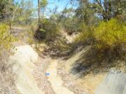
04665 Armadale Quarry, Cableway & Brickworks
Sections of the shale quarry are known to be unstable and susceptible to collapse, and the tunnel is flooded and presently considered unsafe. The quarry is fenced to prevent casual access. The stromatolites have been damaged over time and are not easily discernible.
| Name | Type | Year From | Year To |
|---|---|---|---|
| Robert Oswald Law | Architect | - | - |
| Library Id | Title | Medium | Year Of Publication |
|---|---|---|---|
| 7022 | Images CD No. 26 : assessment images : Mundaring Hotel, Temuka, Faversham, Armadale Brickworks (fmr). | C D Rom | 2004 |
| 9546 | Elsie: her life, letters and love. | Book | 1999 |
| 5566 | History of the Dale Cottages. | Book | 1990 |
| 4718 | Old Armadale Brickworks factory site : Dale Cottages Retirement Village : Armadale, Western Australia : conservation plan. | Heritage Study {Cons'n Plan} | 2000 |
Individual Building or Group
| Epoch | General | Specific |
|---|---|---|
| Original Use | INDUSTRIAL\MANUFACTURING | Brickworks |
| Present Use | PARK\RESERVE | Park\Reserve |
| Original Use | MINING | Other |
| Type | General | Specific |
|---|---|---|
| Wall | STONE | Other Stone |
| Wall | TIMBER | Other Timber |
| Roof | TILE | Other Tile |
| Wall | BRICK | Common Brick |
| General | Specific |
|---|---|
| DEMOGRAPHIC SETTLEMENT & MOBILITY | Workers {incl. Aboriginal, convict} |
| OCCUPATIONS | Mining {incl. mineral processing} |
| PEOPLE | Famous & infamous people |
| OCCUPATIONS | Manufacturing & processing |
| OCCUPATIONS | Technology & technological change |
This information is provided voluntarily as a public service. The information provided is made available in good faith and is derived from sources believed to be reliable and accurate. However, the information is provided solely on the basis that readers will be responsible for making their own assessment of the matters discussed herein and are advised to verify all relevant representations, statements and information.
Constructed from 1902, Constructed from 1901
This place is associated with the original Armadale Brickworks and has historic value as the shale material from this site was used to make the bricks, which were used in the construction of many homes in the area. The place has scientific value as a geological site, and is believed to have been identified by the Geological Society of Australia (WA) in 1979 as one of the most significant geological sites in the metropolitan area.
The Armadale Brickworks Quarry (fmr) is sited on the northern side of Bedfordale Hill Rd with its entrance along Harrison Road. It is fully fenced with access at this point. The former shale quarry is characterised by a tall and wide expanse of exposed bare rubble and rock face, with bush vegetation, including scrub, grass and eucalyptus trees at its base and ridge.
The Armadale Brickworks was developed in 1902, using the shale from a deposit on the western edge of the Darling Range. As this shale was quarried, a large pit was formed, which is still extant. As the depth of the quarry increased, a technique was developed to reach and transport the lower level deposits. A tunnel was cut from the bottom of the quarry (under the Bunbury Road), through which shale was transported on rail trucks, to the brickworks below. These trucks were hitched to a continuous loop of cable, which circled around a wheel head in a wooden loft at the kilns. The tunnel is still accessible from Bunbury Road.
Moderate- High
Good
| Name | Type | Year From | Year To |
|---|---|---|---|
| Robert Oswald Law | Architect | - | - |
| Owner | Category |
|---|---|
| City of Armadale | Local Gov't |
This information is provided voluntarily as a public service. The information provided is made available in good faith and is derived from sources believed to be reliable and accurate. However, the information is provided solely on the basis that readers will be responsible for making their own assessment of the matters discussed herein and are advised to verify all relevant representations, statements and information.

108 Jull St Armadale
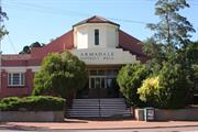
Old Rectory and New Rectory
Saint Matthews Anglican Church
Armadale
Metropolitan
Constructed from 1904 to 1976
| Type | Status | Date | Documents |
|---|---|---|---|
| State Register | Registered | 22 May 2007 | HCWebsite.Listing+ListingDocument, HCWebsite.Listing+ListingDocument |
| Type | Status | Date | Documents |
|---|---|---|---|
| (no listings) |
| Type | Status | Date | Grading/Management | |
|---|---|---|---|---|
| Category | ||||
| Armadale Redevelopment Authority | YES | 23 Mar 2002 | ||
| Anglican Church Inventory | YES | 31 Jul 1996 | ||
| Municipal Inventory | Adopted | 01 Sep 2015 | Category 1 | |
All the buildings are in generally sound condition.
| Name | Type | Year From | Year To |
|---|---|---|---|
| J. J. Talbot Hobbs | Architect | - | - |
| Forbes and Fitzhardinge | Architect | - | - |
| Library Id | Title | Medium | Year Of Publication |
|---|---|---|---|
| 6637 | Images CD No. 20 : Minnawarra, St Marys, St Michaels, St Matthews. | C D Rom | 2003 |
| 9228 | St Matthew's Anglican Church and Old Rectory, Armadale. | Heritage Study {Cons'n Plan} | 2007 |
Individual Building or Group
| Epoch | General | Specific |
|---|---|---|
| Present Use | RELIGIOUS | Office or Administration Bldg |
| Present Use | RELIGIOUS | Housing or Quarters |
| Original Use | RELIGIOUS | Housing or Quarters |
| Original Use | RELIGIOUS | Church, Cathedral or Chapel |
| Style |
|---|
| Late 20th-Century Ecclesiastical |
| Federation Gothic |
| Federation Queen Anne |
| Type | General | Specific |
|---|---|---|
| Wall | BRICK | Common Brick |
| Roof | METAL | Corrugated Iron |
| Roof | TILE | Other Tile |
| General | Specific |
|---|---|
| SOCIAL & CIVIC ACTIVITIES | Religion |
This information is provided voluntarily as a public service. The information provided is made available in good faith and is derived from sources believed to be reliable and accurate. However, the information is provided solely on the basis that readers will be responsible for making their own assessment of the matters discussed herein and are advised to verify all relevant representations, statements and information.
Constructed from 1904, Constructed from 1962
It has aesthetic significance as a fine example of a Federation Gothic ecclesiastical building. It has historic significance representing the role of the Anglican Church in the history of settlement in Armadale. The Church has social significance to members of the Armadale Anglican community.
The Church is a red brick and iron roofed building with brick buttresses with rendered capping and rendered reveals to gothic arched stained windows. Brick extensions were added on the eastern side in 1962 and differ in form and scale to the church but the original building is clearly discernable.
The original Church was built for a cost of ₤573. The Anglican Church has always maintained an important part in the community’s public and spiritual life and continues to maintain a healthy involvement as the parish centre of the region.
Good
| Ref ID No | Ref Name | Ref Source | Ref Date |
|---|---|---|---|
| Foundation Stone | |||
| MHI | 1995 |
| Ref Number | Description |
|---|---|
| No.114 | MI Place No. |
| Reserve | Lot/Location | Plan/Diagram | Vol/Folio |
|---|---|---|---|
| 17 | 2692/691 |
This information is provided voluntarily as a public service. The information provided is made available in good faith and is derived from sources believed to be reliable and accurate. However, the information is provided solely on the basis that readers will be responsible for making their own assessment of the matters discussed herein and are advised to verify all relevant representations, statements and information.
206 Jull St Armadale
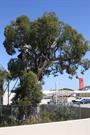
Eucalyptus marginata
Armadale
Metropolitan
Constructed from 1500
| Type | Status | Date | Documents |
|---|---|---|---|
| Heritage Agreement | YES | 16 Apr 2002 | HCWebsite.Listing+ListingDocument |
| Continuing Protection Order | YES | 14 Nov 1997 | |
| State Register | Registered | 09 Sep 2003 | HCWebsite.Listing+ListingDocument, HCWebsite.Listing+ListingDocument |
| Type | Status | Date | Documents |
|---|---|---|---|
| (no listings) |
| Type | Status | Date | Grading/Management | |
|---|---|---|---|---|
| Category | ||||
| Municipal Inventory | Adopted | 01 Sep 2015 | Category 1 | |
| Armadale Redevelopment Authority | YES | |||
| Classified by the National Trust | Classified {Trees} | |||
Tree
| Epoch | General | Specific |
|---|---|---|
| Present Use | OTHER | Other |
| General | Specific |
|---|---|
| SOCIAL & CIVIC ACTIVITIES | Environmental awareness |
| PEOPLE | Early settlers |
This information is provided voluntarily as a public service. The information provided is made available in good faith and is derived from sources believed to be reliable and accurate. However, the information is provided solely on the basis that readers will be responsible for making their own assessment of the matters discussed herein and are advised to verify all relevant representations, statements and information.
Despite its reduced circumstances, the Jarrah tree is significant for its landmark quality.The tree reflects the great age of this species and is a significant remnant of the period prior to European settlement. The girth and age of this Eucalyptus marginata make it valuable as a benchmark site with the potential to contribute to future research on the natural history of Western Australia. The Jarrah tree has played a significant role in the playground activities of Armadale school children from 1904 to 1987 and is highly valued by the local community. This high public regard is illustrated by efforts of community groups to prevent its destruction in 1987 and 1997. The tree contributes to the community’s sense of place by providing a physical link with the history of the development of Armadale It forms an integral part of the Bicentennial Heritage Tree Trail and is included on the Tree Register of the National Trust of Australia (WA).
The tree stood in the grounds of the Armadale Primary School and is fondly remembered by many children who attended the school. The land on which the tree stood was sold by Thomas Saw, one of the earliest settlers in the district, a major property owner and local benefactor, to the Minister for Education to be used as a school site. The Jarrah tree was the subject of a Conservation Order issued on 14 November 1997 after the Minister for Heritage had received 1,147 submissions in favour of conservation.
The tree is less than half its height because of lopping. It was ringbarked by vandals in 1997 causing an impact on the tree’s ability to sustain and generate growth.
| Ref Number | Description |
|---|---|
| No.108 | MI Place No. |
| Reserve | Lot/Location | Plan/Diagram | Vol/Folio |
|---|---|---|---|
| 710 | 2654/895 |
This information is provided voluntarily as a public service. The information provided is made available in good faith and is derived from sources believed to be reliable and accurate. However, the information is provided solely on the basis that readers will be responsible for making their own assessment of the matters discussed herein and are advised to verify all relevant representations, statements and information.
90 Jull St Armadale
Cnr Jull St & Church Av
Armadale
Metropolitan
Constructed from 1936 to 1998
| Type | Status | Date | Documents |
|---|---|---|---|
| State Register | Registered | 26 Aug 2003 | HCWebsite.Listing+ListingDocument, HCWebsite.Listing+ListingDocument |
| Type | Status | Date | Documents |
|---|---|---|---|
| (no listings) |
| Type | Status | Date | Grading/Management | |
|---|---|---|---|---|
| Category | ||||
| Classified by the National Trust | Classified | 08 Jun 1998 | ||
| Armadale Redevelopment Authority | YES | 23 Mar 2002 | ||
| Classified by the National Trust | Classified | 08 Jun 1998 | ||
| Municipal Inventory | Adopted | 01 Sep 2015 | Category 1 | |
| Name | Type | Year From | Year To |
|---|---|---|---|
| Charles Oldham, Harold Boas & Ednie Brown | Architect | - | - |
| Library Id | Title | Medium | Year Of Publication |
|---|---|---|---|
| 10254 | Armadale District Hall | Heritage Study {Cons'n Plan} | 2001 |
Individual Building or Group
| Epoch | General | Specific |
|---|---|---|
| Original Use | SOCIAL\RECREATIONAL | Other Community Hall\Centre |
| Present Use | SOCIAL\RECREATIONAL | Other Community Hall\Centre |
| Style |
|---|
| Inter-War Art Deco |
| Type | General | Specific |
|---|---|---|
| Wall | BRICK | Common Brick |
| Roof | TILE | Other Tile |
| General | Specific |
|---|---|
| SOCIAL & CIVIC ACTIVITIES | Sport, recreation & entertainment |
| SOCIAL & CIVIC ACTIVITIES | Cultural activities |
| DEMOGRAPHIC SETTLEMENT & MOBILITY | Settlements |
This information is provided voluntarily as a public service. The information provided is made available in good faith and is derived from sources believed to be reliable and accurate. However, the information is provided solely on the basis that readers will be responsible for making their own assessment of the matters discussed herein and are advised to verify all relevant representations, statements and information.
Constructed from 1936
The hall is important to the local community because of its aesthetic characteristics. It has landmark qualities in the main street of Armadale and contributes to the aesthetic character of the historic precinct. The building embodies features which are typical of the way of life in Armadale. The building is important as a source of information about the history of human activity in the Armadale region. The building is important to the community as a place valued for its social and cultural associations and it is also significant in contributing to a sense of place.
The building was designed by Oldham Boas and Ednie Brown in 1935 as a multi-purpose hall complete with well-proportioned stage and dressing rooms as well as an adjacent large supper room and kitchen together with a shop complete with its own independent kitchen. Like a few other district halls built at the time of the great popularity of the movies (and the subsequent impact they had on the social life of the community) provision was made for a purpose-built bio-box for film projection. This was constructed above the crush hall and a ticket box placed centrally in the main entrance. Significantly, the stairway to the projection room was accessed from the men's cloakroom since it would have been inconceivable that the projectionist would be other than male. The style of the building both inside and out is typical of the designs of Oldham, Boas and Ednie Browne at the time. It represents the transitional period between the rustic simplicity of the Arts and Crafts style suited to the Armadale area yet adhered to the dawnings of modernism.
The Armadale District Hall is a representative of the architecture of a significant period of improved prosperity and development in the district during the mid-1930s and is one of a number of buildings dating from the Inter-War Years. The building has also been the scene for 60 years of many events of social relevance in the history of the district. With the exception of the present colour scheme, the building has altered very little during the intervening years and still offers a commanding presence overlooking Minnawarra Park and Neerigen Valley from its position at the intersection of Jull Street and Church Avenue. It is adjacent to the historic building now used as the tourist and craft centre and, close to the re-sited Old Church building, forms the basis of a heritage precinct. The City of Armadale has seen fit to preserve the hall in its main thoroughfare enhancing it with a recent coat of pain and full garden scheme. The Hall was opened by the then Lieutenant Governor, Sir James Mitchell in 1936 and attracted a large crowd of local residents on the day.
The building is in an excellent state of repair and maintenance with attractive and well maintained gardens surrounding it.
| Name | Type | Year From | Year To |
|---|---|---|---|
| Oldham Boas and Ednie Brown | Architect | - | - |
This information is provided voluntarily as a public service. The information provided is made available in good faith and is derived from sources believed to be reliable and accurate. However, the information is provided solely on the basis that readers will be responsible for making their own assessment of the matters discussed herein and are advised to verify all relevant representations, statements and information.
Constructed from 1936
The Armadale District Hall has aesthetic value as a competently built hall, which displays the characteristics of the Inter-War Art Deco style used to produce a well composed principal elevation and appropriately embellished interior. It has landmark qualities as a distinctive building set in a prominent, lightly raised, open site. The Hall is associated with the development of Armadale and the immediate district that evolved out of the Depression years. The establishment of the place in 1936 represents the renewed optimism that was emerging at the end of the Depression. As the second community hall built in Armadale, the Armadale District Hall is representative of the increase in population and consolidation of the district which had occurred in the 1920s and continued following the Depression. The hall was designed by eminent Western Australian architectural firm Oldham Boas & Ednie-Brown and constructed by well established builders J.B. Hawkins & Son. Armadale District Hall is highly valued by the local and regional communities for its social, cultural and aesthetic associations and in particular for its use as a picture theatre until c1958. This was illustrated in March 2001, when rallies were staged opposing the redevelopment of the site for commercial use. As the district’s community centre since 1936, and the venue for balls, dances, public meetings, displays, fundraising, wedding receptions, school concerts and similar events, the hall contributes to the local community’s sense of place.
A substantial painted brick and tile building, the hall has timber floors and incorporates a stage, main hall, gallery, lesser hall and kitchens. It is located at the corner of Jull Street and Church Avenue with a commanding position associated with St Matthew’s Church and the Courthouse on other corners of the intersection. The hall is in the Inter-War Art Deco style and above the steps to the main entrance “Armadale District Hall” appears in stucco.
Built in 1936, the Armadale District Hall symbolised the growing community needs, as it replaced the old Mechanics Institute Hall close by. It was used for community purposes and entertainment, including its use as a cinema until c1958, balls, dances, public meetings, displays, fundraising, wedding receptions, school concerts and similar events.
High High to Moderate
Good
| Name | Type | Year From | Year To |
|---|---|---|---|
| Oldham Boas & Ednie-Brown | Architect | - | - |
| Ref ID No | Ref Name | Ref Source | Ref Date |
|---|---|---|---|
| Foundation stone |
| Ref Number | Description |
|---|---|
| No.97 | MI Place No. |
| Reserve | Lot/Location | Plan/Diagram | Vol/Folio |
|---|---|---|---|
| 31 | 3055/950 |
This information is provided voluntarily as a public service. The information provided is made available in good faith and is derived from sources believed to be reliable and accurate. However, the information is provided solely on the basis that readers will be responsible for making their own assessment of the matters discussed herein and are advised to verify all relevant representations, statements and information.

Lot 12 South West Hwy Armadale
Armadale State Brickworks (fmr)
Armadale
Metropolitan
Constructed from 1949 to 1953
| Type | Status | Date | Documents |
|---|---|---|---|
| State Register | Registered | 20 Apr 2007 | HCWebsite.Listing+ListingDocument, HCWebsite.Listing+ListingDocument |
| Type | Status | Date | Documents |
|---|---|---|---|
| (no listings) |
| Type | Status | Date | Grading/Management | |
|---|---|---|---|---|
| Category | ||||
| Municipal Inventory | Adopted | 01 Sep 2019 | Category 1 | |
| Armadale Redevelopment Authority | YES | |||
| Classified by the National Trust | Classified | 08 Sep 2008 | ||
fair to poor
| Library Id | Title | Medium | Year Of Publication |
|---|---|---|---|
| 5960 | Armadale State Brickworks, brick presses, workrooms and dust room. | Video | 2001 |
| 8381 | Armadale brickworks dustroom and machinery shed (fmr). Condition and remedial works report. DRAFT | Heritage Study {Other} | 2006 |
Historic site
| Epoch | General | Specific |
|---|---|---|
| Original Use | INDUSTRIAL\MANUFACTURING | Brickworks |
| Present Use | VACANT\UNUSED | Vacant\Unused |
| Style |
|---|
| Vernacular |
| Type | General | Specific |
|---|---|---|
| Wall | ASBESTOS | Other Asbestos |
| Other | METAL | Steel |
| General | Specific |
|---|---|
| DEMOGRAPHIC SETTLEMENT & MOBILITY | Immigration, emigration & refugees |
| SOCIAL & CIVIC ACTIVITIES | Government & politics |
| OCCUPATIONS | Manufacturing & processing |
| OUTSIDE INFLUENCES | Depression & boom |
This information is provided voluntarily as a public service. The information provided is made available in good faith and is derived from sources believed to be reliable and accurate. However, the information is provided solely on the basis that readers will be responsible for making their own assessment of the matters discussed herein and are advised to verify all relevant representations, statements and information.
Constructed from 1949, Constructed from 1953
The Armadale State Brickworks (fmr) is a utilitarian example of a mid twentieth century factory designed around the brickmaking process and housing a significant and visually impressive collection of machines. The place clearly demonstrates the brickmaking process from the delivery of the primary material through the crushing process to the pressing and drying of the bricks. The place has associations with the development of the brickmaking industry in the Armadale district dating from 1897 through to the present day. The brick presses manufactured by Thos. C. Fawcett in the 1920s have historic significance as the only known extant examples of their type in Australia. The place represents an example of an industry established as a result of the Scaddan Labour Government’s Trading Concerns Act of 1912. The place was established as a result of building material shortages in the Post World War 2 period. The place has a very high social and historical significance as demonstrated by the work reunion held in 2002 attended by approximately 400 people, and by its identification by the Armadale & Districts Brickworks Preservation Group and the Institution of Engineers (WA Branch) as a site containing equipment worthy of preservation. The place has associations with the post war immigration program through the employment of migrant labour.
A steel framed, corrugated asbestos cement clad former industrial facility comprising a dust room and machine shed designed around five pan mills, elevators, return conveyors and spinners for extracting fine aggregate for brick making, and eight brick presses. The Armadale State Brickworks (fmr) is located on the western side of the South Western Highway approximately five kms south of the Armadale town centre. The site comprises an area of approximately twelve hectares and is currently an operating brick yard and sales centre. The building constructed as part of the development of the Armadale Brickworks No. 2. plant in the 1950s is located on the southern section of the site and accessed from the main entrance road located adjacent to the southern side boundary. The main extant industrial building comprises a large machine shed constructed of steel frame clad with corrugated asbestos cement sheets with a narrow, double volume structure along the eastern end that comprises the dust room. The dust room is open on the southern end. The ground on which the building is constructed slopes down from the main road , and therefore the entry to the dust room from the east is at ground level, while steps down from the road on the south provide access to the machine shed locate don the lower side of the site. The interior of the dust room comprises a long narrow space with a high roof. It is linked to the remainder of the building by a staircase located approximately in the centre of the space. The dust room contains five sets of crushing machines that are spaced equally along the room. The crushing machine system comprises timber box framed elevators and return conveyors linked to the five Bradley and Craven pan mills (dating from the 1920s and 1930s) and to the five Monier ‘spinners’ that replaced the earlier machines in the 1970s. All the machines and associated elements that comprise the five systems remain extant. The process produced a large quantity of dust, hence the name of the dust room. The adjacent machine shed contains the eight Thos. C. Fawcett brickmaking presses (dating from the 1920s). These are arranged in a line parallel to each other along the eastern end of the shed. Each press has an electrical supply adjacent and all originally had timber tool cupboards. Some of the cupboards and other elements are extant while others have been removed in the period since the closure of the plant. Some of the brick presses have had parts removed, possibly to repair working presses prior to the closure. Brass tags identifying the presses remain extant. Approximately centrally along the row of presses, a steel framed mesh enclosure indicates the former foreman’s office. This remains largely as left at the time of closure complete with desk, tools and even a pair of boots. On the wall at the back of the former office some names have been marked on the wall lining. There is a saw tooth roof with skylights over the section of the machine shed that contains the brick presses. The remainder of the building previously contained the zig zag kilns (not extant) and a toilet and shower block (extant).
Construction of the Armadale State Brickworks (fmr) began in the early 1950s with part of the plant going on line in 1953/54. The plans for the No. 2 Pressed Brickworks were drawn by the State Government’s Public Works Department (PWD). Those sections related specifically to the crushing plant and brickmaking operations were done in association with equipment suppliers including Redler Conveyors Ltd from Gloucestershire, England and Thos. C. Fawcett Ltd from Leeds, England. The plant supplied by the Thos. C. Fawcett engineering company included second-hand patented brickmaking and pressing machines dating from the 1920s (still extant, located in the machine shed). The pan mills dating from the 1920s/1930s (located in the dust room) were produced by English engineering company Bradley & Craven Ltd, Wakefield. The No. 2 Pressed Brickworks comprised two parts: the dust room in which the primary material went through the crushing process; and, the machine shed in which the brick presses and kilns operated. The zig zag kilns in the No. 2 section of the brickworks were demolished in the mid 1980s but it was not until the 1990s that brickmaking ceased entirely at the former State Brickworks. The Thos. C. Fawcett brickmaking and pressing machines were used right up to this time.
Moderate to High High
Good
| Ref ID No | Ref Name | Ref Source | Ref Date |
|---|---|---|---|
| ARA Assessment Documentation |
| Ref Number | Description |
|---|---|
| No.105 | MI Place No. |
| Reserve | Lot/Location | Plan/Diagram | Vol/Folio |
|---|---|---|---|
| 12 | 1500/671 |
This information is provided voluntarily as a public service. The information provided is made available in good faith and is derived from sources believed to be reliable and accurate. However, the information is provided solely on the basis that readers will be responsible for making their own assessment of the matters discussed herein and are advised to verify all relevant representations, statements and information.
the brick presses manufactured by Thos. C. Fawcett in the 1920s have historic significance as the only known extant examples of their type in Australia; the place clearly demonstrates the brickmaking process from the delivery of the primary material through the crushing process to the pressing and drying of the bricks; the place has very high social and historical significance as demonstrated by the work reunion held in 2002 attended by approximately 400 people, and by its identification by the Armadale & Districts Brickworks Preservation Group and the Institution of Engineers (WA Branch) as a site containing equipment worthy of preservation; the place was established as a result of building material shortages in the Post World War Two period and also employed a large number of European migrants subsequent to their arrival in Australia as part of the post war immigration program;2 Armadale Brickworks Dustroom & Machinery Shed (fmr) the place has associations with the development of the brickmaking industry in the Armadale district dating from 1897 through to the present day; the place represents an example of an industry established as a result of the Scaddan Labour Government’s Government Trading Concerns Act of 1912; and, the place is a utilitarian example of a mid twentieth century factory designed around the brick making process and housing a significant and visually impressive collection of machines.
Armadale Brickworks Dustroom & Machinery Shed (fmr) is a steel framed and clad building, which incorporates a double volume space designated for the ‘dustroom’ (in which the primary material went through the crushing process); and, the single-storey machinery shed (in which the brick kilns and presses operated). Located within this structure are five pan mills, elevators and conveyors, spinners, and eight Thos. C. Fawcett brickmaking and pressing machines. (For a more detailed physical description, including the industrial process, refer to Bizzaca, K. & Rosario, R., ‘Armadale State Brickworks Dustroom & Machinery Shed (fmr)’, assessment documentation, August 2004 with subsequent additions and amendments by HCWA staff & Register Committee.
Assessment 2008 Work began on the No. 2 State Brickworks at Armadale; of which Armadale Brickworks Dustroom & Machinery Shed (fmr) formed part, in 1949/1950. Its establishment was due to two main factors: the first being a result of the Government Trading Concerns Act of 1912 implemented by John Scaddan’s Labour Government to supplement Western Australia’s relatively underdeveloped economy; and, the second as a means of dealing with the critical shortage of building materials that occurred subsequent to the massive building boom in housing and public works in the Post World War Two period. Construction of Armadale Brickworks Dustroom & Machinery Shed (fmr) itself occurred in the early 1950s. The plans were drawn by the Public Works Department in association with equipment suppliers. The plant supplied by the Thos. C. Fawcett engineering company of Leeds included second-hand patented brickmaking and pressing machines dating from the 1920s (located in the machine shed). The pan mills dating from the 1920s/1930s (located in the dustroom) were produced by English engineering company Bradley & Craven Ltd, Wakefield. The State Building Supplies, formed by the amalgamation of the State Brickworks and State Saw Mills in 1957, was purchased by Hawker Siddeley Group Ltd of London in 1961 and the Armadale site continued to produce bricks. In 1972, the Monier company became the owners of the factory, followed by Bristile Ltd in 1983. Bristile was taken over by Austral Bricks in 2003. The kilns in the machinery shed were demolished in the mid 1980s. By the 1990s brickmaking ceased entirely at the former State Brickworks coinciding with the decision for the 1970s Monier-built factory to produce the bulk of the bricks. The former State Brickworks site, with the exception of Armadale Brickworks Dustroom & Machinery Shed (fmr), was approved for demolition in November 2005. In 2008, Armadale Brickworks Dustroom & Machinery Shed (fmr) is no longer in use. (For a more detail history refer to Bizzaca, K. & Rosario, R., ‘Armadale State Brickworks Dustroom & Machinery Shed (fmr)’, assessment documentation, August 2004 with subsequent additions and amendments by HCWA staff & Register Committee.)
This information is provided voluntarily as a public service. The information provided is made available in good faith and is derived from sources believed to be reliable and accurate. However, the information is provided solely on the basis that readers will be responsible for making their own assessment of the matters discussed herein and are advised to verify all relevant representations, statements and information.
2 South Western Hwy Armadale
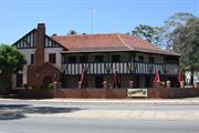
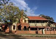
Narrogin Hotel
Narrogin Inne
Armadale
Metropolitan
Constructed from 1999, Constructed from 1856
| Type | Status | Date | Documents |
|---|---|---|---|
| State Register | Registered | 20 Feb 2004 | HCWebsite.Listing+ListingDocument, HCWebsite.Listing+ListingDocument |
| Type | Status | Date | Documents |
|---|---|---|---|
| (no listings) |
| Type | Status | Date | Grading/Management | |
|---|---|---|---|---|
| Category | ||||
| Municipal Inventory | Adopted | 01 Sep 2015 | Category 1 | |
| Municipal Inventory | Adopted | 01 Dec 2018 | Category 1 | |
| Local Heritage Survey | Adopted | 25 Nov 2019 | Category 1 | |
| Classified by the National Trust | Classified | 08 Jun 1998 | ||
| Classified by the National Trust | Classified | 08 Jun 1998 | ||
| Art Deco Significant Bldg Survey | Completed | 30 Jun 1994 | ||
| Name | Type | Year From | Year To |
|---|---|---|---|
| Eustace Cohen | Architect | - | - |
| John B. Fitzhardinge | Architect | - | - |
| Library Id | Title | Medium | Year Of Publication |
|---|---|---|---|
| 5735 | Report of a European heritage survey : South Western Highway, Albany Highway to Burndale Road Planning Study Armadale, Western Australia. | Report | 2001 |
| 9546 | Elsie: her life, letters and love. | Book | 1999 |
Individual Building or Group
| Epoch | General | Specific |
|---|---|---|
| Original Use | COMMERCIAL | Hotel, Tavern or Inn |
| Present Use | COMMERCIAL | Hotel, Tavern or Inn |
| Style |
|---|
| Inter-War Old English |
| Type | General | Specific |
|---|---|---|
| Roof | TIMBER | Shingle |
| Wall | BRICK | Common Brick |
| General | Specific |
|---|---|
| SOCIAL & CIVIC ACTIVITIES | Sport, recreation & entertainment |
| OCCUPATIONS | Hospitality industry & tourism |
This information is provided voluntarily as a public service. The information provided is made available in good faith and is derived from sources believed to be reliable and accurate. However, the information is provided solely on the basis that readers will be responsible for making their own assessment of the matters discussed herein and are advised to verify all relevant representations, statements and information.
Constructed from 1980, Constructed from 1979, Constructed from 1856, Constructed from 1937, Constructed from 1999
The place has aesthetic value as an outstanding and rare example of a building constructed in the Inter-War Old English style, and exhibits detailing consistent with this style including its picturesque asymmetrical form, warm-coloured face-brickwork and distinctive timber panelling. With its distinctive building form and prominent location near the intersection of Albany Highway and South West Highway, the place is a well-known landmark in Armadale. The place is one of a number of similar buildings dating from the Inter-War and Post-War period which are located on the east side of South West Highway, in central Armadale. The place is situated on a site at the junction of Albany and South Western highways, which has functioned continuously as the site of a hotel since at least 1856. The original inn on the site served mail and passenger coach services to Albany and Bunbury prior to the opening of the Great Southern (1899) and South Western (1893) railways. The Duke of Gloucester is believed to have stopped at the place on his way to visit Fairbridge Farm in 1933. The place was closely associated with local farmer and businessman, Thomas Saw, who was responsible for the 1856 buildings and the first wayside inn licence for the place, and who owned the place until 1910. Along with the nearby Muckross Tearooms and Kate Wilkinson’s Cottage, the place is one of a number of buildings dating from the early 20th century associated with Kate Wilkinson, a well-known and respected local businesswoman. The place is of significance to the local community as one of the early stopping places for coaches, and as a venue for socialisation by the local community and travellers from 1856 to the present. The place is valued by the community as a long-standing social venue and landmark.
The Narrogin Inn is a prominent building facing Albany Highway. The two-storey building has a gable roof of Marseille tiles and face brickwork to the chimney and entry. The building is painted a light yellow colour with contrasting green timber posts to the first floor balcony. Patterned brickwork and brick detailing to the chimney and entry distinguishes it from the rest of the building. A timber framed two-storey verandah with paneled balustrade extends to the west of the gable bay, wrapping around the faceted corner. Mounted wrought iron signage to the brickwork reads ‘Ye Olde Narrogin Inne’. The first floor has exposed timber rafters with painted rendered walls and casement windows while the first floor balcony is half timbered infilled with compressed fibre cement sheeting. The building also consists a single-storey drive-in bottleshop (c.1960s), a courtyard alfresco eating area and a reception area for the hotel accommodation. The reception area to the east has curved timber bracketed awnings to the entry area on face brick. The chimneys are face brick with a hip roof to the south side of the first floor. The rear beer garden is also enclosed with a garden wall, and features a large under-cover section (1999). There are mature trees to the alignment of Albany Highway with one mature tree located outside the Inn. To the rear of the building is a car park and motel, with mature plantings supporting the landscape component and setting for the building. The front fence has slim line bricks to the top section and standard brick to the base.
Narrogin Inne was designed by architects Eales, Cohen and Fitzhardinge and built by the Todd Brothers in 1937 in the Inter-War Old English style. The building replaced the hotel section of an early single-storey inn, originally built in 1856 by Thomas Saw, a farmer in the district near Wungong Brook. Following improvements to the road between Perth and Albany, Saw applied for a wayside licence for Middleton’s house (as it was then known) with his father-in-law, William Gibbs. In the application, the house was described as “Situated on the Neerigen Brook at the junction of Albany and Murray Roads about 20 miles from Perth and containing 1 sitting room and 2 bedrooms exclusive of those required for our own use.” Saw improved the building with single brick walls (the bricks were handmade on site) and a shingle roof. He named the place Ye Olde Narrogin Inne after the district, which was then known as Narrogin for the Narrogin (Neerigen) Brook. Ye Olde Narrogin Inne soon became the first staging post from Perth for the mail cart, replacing the Barracks at Kelmscott. Fresh horses were provided from Paradise Farm (see Place 027), two miles further north along the Albany Road. Traffic gradually increased along the Albany Road and small stores selling local produce were established around Ye Olde Narrogin Inne, and along the road through to Kelmscott. Ye Old Narrogin Inne established the Armadale area as the commercial centre of the district. As well as being a popular staging post and wayside hotel, the place also hosted the first meeting of the Kelmscott Roads Board in 1894. The Duke of Gloucester is reputed to have stopped at Ye Olde Narrogin Inne on his way to visit Fairbridge Farm in 1933. Kate Wilkinson purchased Ye Olde Narrogin Inne in 1910, who ran the place until 1919, when Maud Mary Kerrigan leased the property. In 1926, James Samuel Devlin, hotelkeeper of the Criterion Hotel in Perth, leased the place. In the 1920s, the place was considered a popular honeymoon venue, not too far out from Perth, in a pleasant area that could be reached by a short train journey. In 1933 the title to Ye Olde Narrogin Inne was acquired by Margaret and William Gaynor. John Spencer Kerbey leased the place from 1934, and his wife Myra was recorded as the licencee in 1941- 42. In 1947, Margaret Gaynor died and the title passed onto her husband. On his death in 1958, the title passed to Myra Kerbey. Owners of Ye Olde Narrogin Inne from the 1960s-1990s were A.J. Glanville & Company Pty Ltd (1966-67), the Swan Brewery Company Ltd (1967-77), Takee Pty Ltd (1977-1982), TVW Enterprises Ltd (1982-1993), and Palikar Holdings (1993-1999). In 1937, the older western section of Ye Old Narrogin Inne was demolished and a two-storey structure in the Inter-War Old English style was built on the site. The single-storey eastern (1890's) section of the place was retained as the accommodation wing. The place underwent refurbishment in 1979-80 as part of the new Pioneer Village development. In 1999, architectural firm Erwin Biemel & Associates was engaged by the current owners to upgrade and modernise the facilities. (Source: Heritage Council of Western Australia Assessment Documentation, #00092 Ye Olde Narrogin Inne, prepared by Irene Sauman, Historian, and Alan Kelsall, Kelsall Binet Architects, 20/02/2004)
High High
Good
| Name | Type | Year From | Year To |
|---|---|---|---|
| Eales, Cohen and Fitzhardinge | Architect | 1937 | - |
| Erwin Biemel & Associates | Architect | 1999 | - |
| Ref ID No | Ref Name | Ref Source | Ref Date |
|---|---|---|---|
| HCWA Assessment Documentation |
| Ref Number | Description |
|---|---|
| No.12 | MI Place No. |
| Reserve | Lot/Location | Plan/Diagram | Vol/Folio |
|---|---|---|---|
| 25 | 10033 |
This information is provided voluntarily as a public service. The information provided is made available in good faith and is derived from sources believed to be reliable and accurate. However, the information is provided solely on the basis that readers will be responsible for making their own assessment of the matters discussed herein and are advised to verify all relevant representations, statements and information.
Constructed from 1937
| Name | Type | Year From | Year To |
|---|---|---|---|
| Forbes and Fitzharding | Architect | - | - |
| Reserve | Lot/Location | Plan/Diagram | Vol/Folio |
|---|---|---|---|
| A184852 |
This information is provided voluntarily as a public service. The information provided is made available in good faith and is derived from sources believed to be reliable and accurate. However, the information is provided solely on the basis that readers will be responsible for making their own assessment of the matters discussed herein and are advised to verify all relevant representations, statements and information.

Summit View Armadale
Off Bedfordale Rd Note: the land has been purchased by the State and is currently being reserved with a management order to be issued to the City of Armadale. Tenure details will not be finalised until this action is complete. EW 4/12/02
Forbes' Shaft
Kelmscott Mine; Neerigen Brook Mine
Armadale
Metropolitan
Constructed from 1846 to 1847
| Type | Status | Date | Documents |
|---|---|---|---|
| State Register | Registered | 09 Sep 2003 | HCWebsite.Listing+ListingDocument, HCWebsite.Listing+ListingDocument |
| Type | Status | Date | Documents |
|---|---|---|---|
| (no listings) |
| Type | Status | Date | Grading/Management | |
|---|---|---|---|---|
| Category | ||||
| Municipal Inventory | Adopted | 01 Sep 2015 | Category 1 | |
| Municipal Inventory | Adopted | 01 Dec 2008 | Category 1 | |
| Library Id | Title | Medium | Year Of Publication |
|---|---|---|---|
| 12326 | Archaeological survey: Cole's shaft, Armadale | Heritage Study {Other} | 2002 |
Historic Site
| Epoch | General | Specific |
|---|---|---|
| Present Use | VACANT\UNUSED | Vacant\Unused |
| Original Use | MINING | Other |
| Style |
|---|
| Other Style |
| Type | General | Specific |
|---|---|---|
| Other | METAL | Lead |
| Other | METAL | Other Metal |
| Other | METAL | Copper |
| Wall | STONE | Granite |
| General | Specific |
|---|---|
| OCCUPATIONS | Mining {incl. mineral processing} |
This information is provided voluntarily as a public service. The information provided is made available in good faith and is derived from sources believed to be reliable and accurate. However, the information is provided solely on the basis that readers will be responsible for making their own assessment of the matters discussed herein and are advised to verify all relevant representations, statements and information.
Constructed from 1846, Constructed from 1847
The place is the earliest mine in the State and many early colonists including Secretary Sholl, and other principals, Shenton, Leake and Marmion were in the committee The place is a benchmark site as the first mining shaft to be sunk in Western Australia. The shaft and surroundings have the potential to yield information through archaeological excavation to yield information regarding early mining practices. The place is representative of a number of shafts put down in the Darling Range over ensuing years in search of lead, copper, silver and gold.
Cole’s Shaft constitutes a vertical shaft, approximately 10 metres deep, located amongst scrub and trees near the top of Bedfordale Hill, not far from the northwest boundary of the lot. The shaft is characterised by a mullock heap of broken quartz and granite, which has been covered with a galvanised metal grille and viewing platform. The platform is entirely trafficable, with a trapdoor and ladder providing limited access to the bottom of the shaft, and a safety rail along the bank and above the shaft.
Cole’s Shaft, first sunk in 1846-7, is a vertical mineshaft about 10 metres in depth on the western face of Bedfordale Hill in the Darling Range. In August 1846, a public meeting was held in Perth, and a committee appointed to organize the formation of a company to systematically investigate the mineral resources of the colony. In October 1846, the prospecting efforts of Thomas Gilman and Samuel Duffield were successful, the pair having discovered promising lead deposits in the Darling Range, a short distance south of Neerigen Brook on land owned by John Adams and Thomas Middleton. After news broke of the discovery of a coal seam on the Irwin River located during explorations in 1846 by the Gregory brothers, a further 1,000 shares in the W.A. Mining Co. were taken up, allowing it to commence operations in earnest. The committee began negotiations for the importation of mining expertise from South Australia, eventually engaging a qualified mineralogist, Dr Ferdinand von Sommer, and a mine foreman named Thomas, to proceed to Western Australia for a six-month term. At the end of November 1846, two members of the W.A. Mining Co. accompanied Gilman and Duffield to their find. The subsequent report of this was so encouraging that the company paid the prospectors a £20 reward and made arrangements with the relevant landowners to enable them to commence mining operations immediately. The negotiations to acquire the land surrounding the find resulted in the purchase of 50 acres of Canning Location 31 from Adams and Middleton for £62-10-0. Additional mineral discovery to the south of the area resulted in the purchase from the government, for £159-0-0, of Canning Location 24, 160 acres adjoining the south boundary of the 50-acre block. J.W. Gregory superintended the initial mining work from 4 December 1846 until the arrival of Dr von Sommer, and miners sent from Perth were engaged at 6 shillings per day, with rations provided. The operation started on the lead lode was known as the ‘Kelmscott Mine’ or ‘Cole’s Shaft’, after Henry Laroche Cole, one of the shareholders of the mining company. On 26 December 1846, the Perth Gazette announced that copper had been found amongst the lead ore, while the deepening of Cole’s Shaft was temporarily abandoned in favour of putting down another shaft nearby. Under the direction of Thomas, this was excavated to a depth of about 14 metres, with few mineral indications in the quartz vein being followed. Various other costeens and trenches were opened out, before operations resumed in Cole’s Shaft, which eventually reached a depth of about 9 metres, with encouraging prospects of improving yields. After the expiry of Thomas and von Sommer’s contracts with the WA Mining Co., the work at Cole’s Shaft was carried on under the management of Edward Forbes. Twelve months after the formation of the company, Forbes reported that, although delays had been experienced due to winter rains filling the shaft, the mineral indicators were improving. By December 1847, Cole’s Shaft was 32 feet (9.7 metres) deep, and was then squared, to enable the vein to be followed in its underlay. Although another call for funds was made upon shareholders, interest in further deepening Cole’s Shaft appears to have waned for a time thereafter, while the company pursued other mineral discoveries. Joseph Batt was contracted to extend the shaft in 1849, and is reported to have sunk it a further 12 feet (3.66 metres) without encouraging results. In 1854, the local press suggested that the WA Mining Co. was considering deepening ‘Forbes’ shaft’ (Cole’s Shaft) near Kelmscott, because assays of the quartz had revealed auriferous properties. Whether or not any further work was carried out at the site is unknown. The WA Mining Co. was finally wound up in 1906, after it had been 60 years in unregistered existence. Though there are claims that this former silver/lead mine was WA’s first mining venture in the early 1840s, evidence suggests that mining did not begin in earnest until 1869 as part of a series of other mining leases along this general area of the scarp. The mine was worked spasmodically until about 1908-09, when the main shaft was over 86 feet deep. Buildings and equipment were removed a few years later and in 1976 the mine-shafts were filled in. The area around Cole’s Shaft remained unworked for many years. In 1999, it was subdivided into residential lots and later sold.
Low High
Good
| Ref ID No | Ref Name | Ref Source | Ref Date |
|---|---|---|---|
| HCWA | 2005 |
| Ref Number | Description |
|---|---|
| No.3 | MI Place No. |
| Reserve | Lot/Location | Plan/Diagram | Vol/Folio |
|---|---|---|---|
| 46948 | 49 | 33541 | 3130/42 |
This information is provided voluntarily as a public service. The information provided is made available in good faith and is derived from sources believed to be reliable and accurate. However, the information is provided solely on the basis that readers will be responsible for making their own assessment of the matters discussed herein and are advised to verify all relevant representations, statements and information.
Lot 50 Canning Mills Rd Kelmscott
Address includes: Lots 51 & 52 Turner Rd, Kelmscott; Lots 400, 51 & 52 Canning Mills Rd, Roleystone; Lots 301-304 Contour Rd, Roleystone; Lot 3089 Canning Dam Rd, Ashendon. VFL. Also in City of Gosnells. The channel runs adjacent to Channel Road for 16 kms from Roleystone to Gosnells (now Martin). Registered curtilage DOES NOT include central section that runs through residential areas of Roleystone (low authenticity)
Contour Channel/Fireplaces
Two Stone Chimneys
Armadale
Metropolitan
Constructed from 1935 to 1937
| Type | Status | Date | Documents |
|---|---|---|---|
| State Register | Registered | 03 Jun 2005 | HCWebsite.Listing+ListingDocument, HCWebsite.Listing+ListingDocument |
| Type | Status | Date | Documents |
|---|---|---|---|
| (no listings) |
| Type | Status | Date | Grading/Management | |
|---|---|---|---|---|
| Category | ||||
| Municipal Inventory | Adopted | 01 Dec 2008 | Category 1 | |
| Municipal Inventory | Adopted | 01 Sep 2015 | Category 1 | |
| Classified by the National Trust | Classified | 28 Aug 1995 | ||
| Art Deco Significant Bldg Survey | Completed | 30 Jun 1994 | ||
| Aboriginal Heritage Sites Register | Recorded | |||
03830 Canning Dam
The condition of Canning Contour Channel (fmr) ranges from excellent to poor. Some sections are in good condition, with little change to the fabric since construction in 1937. However, other parts are missing or have been severely damaged through intrusion by rocks or natural bush growth from the surrounding terrain.
| Name | Type | Year From | Year To |
|---|---|---|---|
| E. W. Tindale, the Chief Engineer | Architect | - | - |
| Victor Munt and Don Munro, Resident Engineers | Architect | - | - |
| Russell (RJ) Dumas, Engineer in Charge of Construction | Architect | - | - |
| Library Id | Title | Medium | Year Of Publication |
|---|---|---|---|
| 10173 | Canning Dam: a golden era | Book | 1983 |
| 6025 | Canning contour channel : heritage assessment. | Heritage Study {Other} | 2003 |
| 10136 | Canning Dam: historical engineering marker. Unveiling ceremony 2 September 1998 | Brochure | 0 |
| 10137 | Our Dam: Canning Dam | Brochure | 1997 |
| 9984 | Perth's early water supplies. Australian Heritage Engineering Record. | Book | 1984 |
Individual Building or Group
| Epoch | General | Specific |
|---|---|---|
| Present Use | VACANT\UNUSED | Vacant\Unused |
| Original Use | GOVERNMENTAL | Other |
| Original Use | GOVERNMENTAL | Reservoir or Dam |
| Original Use | Transport\Communications | Water: Other |
| Style |
|---|
| Other Style |
| Type | General | Specific |
|---|---|---|
| Wall | STONE | Local Stone |
| Wall | CONCRETE | Other Concrete |
| General | Specific |
|---|---|
| OUTSIDE INFLUENCES | Depression & boom |
| DEMOGRAPHIC SETTLEMENT & MOBILITY | Workers {incl. Aboriginal, convict} |
| SOCIAL & CIVIC ACTIVITIES | Community services & utilities |
| OUTSIDE INFLUENCES | Water, power, major t'port routes |
This information is provided voluntarily as a public service. The information provided is made available in good faith and is derived from sources believed to be reliable and accurate. However, the information is provided solely on the basis that readers will be responsible for making their own assessment of the matters discussed herein and are advised to verify all relevant representations, statements and information.
Constructed from 1935, Constructed from 1937
The contour channels and associated structures have aesthetic value as the remains of a significant engineering construction that although man-made, sits harmoniously within the natural environment. The place is an important example of the original water transportation system and demonstrates the hard work required of the labour force during that time. The place is of significant value because of the potential of the site to contribute to the understanding of the water transportation method. The place is a rare example of a structure that was designed and constructed between 1935 & 1937 for the transportation of water. The continued use of parts of the channel as a walking path by local residents reflects its ability to interest people beyond its original function.
The contour channel comprises a series of open concrete channels connected with cast iron pipe siphons over the gullies. The channel follows the contours of the Darling Scarp between Canning Dam and Martin, and is approximately 1.5 metres wide at the base with raking sides at 45o banking up to the natural ground level. At ground level the channel is approximately 5 metres wide, with an overall depth of approximately 2 metres. Together with the channels, there are two stone chimneys and a number of associated works including stilling ponds, a flow measurement building and flume.
The Canning Contour Channel was originally a (16 kilometre long) series of water channels connected by piped sections over gullies, the only contour channel built in Western Australia for the transport of potable water. Built between 1935-37 for the Metropolitan Water Supply, Sewerage and Drainage Board, the Canning Contour Channel had a number of associated works such as the ‘stilling’ chambers and the Gosnells Screens (both 1937). The idea of an open contour water channel had first been recommended in a 1920 report, as a more economical means of conveying potable water, compared to a pipeline. In 1935, E. W. Tindale, the Director of Works for the Canning Dam construction supported this conclusion. He had seen this type of delivery system work successfully in Victoria and believed it could also work well in Western Australia. The projected cost of the Contour Channel and associated pipeline was £155,000. (The actual cost of the work was £125,000.) The Canning Contour Channel construction commenced in June 1935, under the supervision of Public Works engineers, E.H. Oldham and J.W. Allen. Until its completion in 1937, all water from the Canning Reservoir to Perth was conveyed through a 762mm pipeline from the dam to Kelmscott, and a 914mm pipeline from there to the storage reservoir at Mt Eliza in King’s Park. The pipeline to Gosnells was only a temporary measure, however. Once the rising dam wall increased the storage capacity of the partly completed reservoir and the volume of water available, the water was conveyed through the Canning Contour Channel to Gosnells, and by pipeline the rest of the way. The new contour channel followed the Canning River Valley for a distance of 16kms, to a point in the foothills above Gosnells. From there, a 1.37m pipe took the water to Cannington, where it connected with mains to Fremantle and Mt Eliza. The contour channel walls were constructed of concrete, with a base of local gravel, and were cut into the sides of the hilly terrain. In addition, a number of piped siphons were used to pass the channel water from one side of the valley to the other or to cross under existing roads. As the channel passed through thick bush and, at times, traversed extremely steep-sided valleys and gullies, access was difficult. Due to the difficult terrain, little mechanization was used in the building of the contour channel. However, light rail tracks were laid in the completed parts of the channel, to take equipment and pipes to the workface. In addition, horses and carts were used to take equipment into the areas that were not too steep. Most of the construction work was, however, carried out by workmen using the basic implements of picks, shovels and wheelbarrows, and simple pulleys, with block and tackle, were used to position the cast iron siphon pipes. The workers employed on the construction of the channel lived in camps at various places along the channel. The camps utilized tents, with few permanent built structures, except for some stone chimneys, used to dry the workers’ clothing, when required. The ‘sustenance’ workers involved in the project were drawn from the large body of unemployed men during this period of economic depression. However, many of the foremen and lead gangers were permanent Water Supply staff. In January 1937, 320 men were laid off when the channel and the pipe main were completed. Water from the Canning Dam was released into twin (parallel) ‘stilling chambers’, 200m from the dam, then passed through a flow recorder, and afterwards ran over boarded weirs into the concrete-lined open contour channel to the Gosnells screens. At this point, the water was filtered of any polluting matter, then piped to Perth. From 1954, the water was also chlorinated at the Gosnells site. The Canning Contour Channel was an integral part of the Perth water supply from the time of its completion until 1975. During the period of its operation, the maintenance of the contour channel was a daily task, for up to three gangs of workmen. Each day during the summer months, an inspector walked the full 16km length to report on its condition. If possible, problems would be dealt with on the spot. Otherwise, the location of the problem would be noted, and a team would then go in to fix any obstructions, or cracks in the concrete walls. Further maintenance work included the removal of algae, clearing vegetation from the banks on either side of the channel, and checking the stability of the land on the high side of the channel to prevent rock falls creating obstructions. From its commencement of operation, the Canning Contour Channel required constant upkeep to maintain its efficiency. For example, up to 20% of the water flowing along the channel was lost in leakage, with frequent small breaks and cracks requiring regular attention. In addition, when it rained heavily in the catchment area, dirt, bark, leaves and other matter, would pollute the water. In this case, the Gosnells Screens at the terminus of the Canning Contour Channel played an important role in cleaning the water before it entered the main pipeline to Perth. This filtering system consisted of a battery of six fine wire screens, which removed debris, including the remains of wildlife that became trapped in the swiftly flowing water of the channel. Prior to the installation of the chlorinating plant in 1954, samples of water were taken from the screening chamber weekly, and examined in the bacteriological laboratories of the Health Department. In 1950, a major disruption to Perth’s water supplies occurred, when a section of the contour channel near Araluen collapsed, and water restrictions had to be imposed on the city. Supplies were restored, by the extension of one of the existing siphons, to bypass the collapsed section of the channel. The Canning Dam was the main source for Perth’s water supply until the completion of Serpentine Dam in 1961. However, despite the vulnerability of Canning Contour Channel to malfunction, it was not until the 1973 that an alternative to this method of transporting water was introduced. At this time, the construction of a tunnel from the Canning Dam to Roleystone was commenced. In 1975, the Canning Contour Channel was decommissioned. On 17 January of that year, the newly completed Canning Tunnel was officially opened, by the Minister for Works and Housing. However, as a precaution, the Canning Contour Channel continued to be maintained in operational order, and opened to a flow of water in the summer for two years after 1975. In 2005, the Canning Contour Channel is no longer used for the transport of water, with the route now used mainly as a walking trail. There are also two stone chimneys along the route of Canning Contour Channel, the remnants of the campsites of workers on the project. The first chimney is situated 80 metres down a track from McNess Drive and 150m from the Canning Contour Channel. The track is one kilometre north of the junction between McNess Drive and the road to the north wall of the Canning Dam. The second chimney is visible from McNess Drive on the right hand side of the road whilst travelling north. The chimney is approximately 2.5kms from the junction of McNess Drive and the Canning Dam north wall road, located in a designated picnic site. There is also a third chimney located on Peet Road, 750m north of the junction of Peet Road and Brookton Hwy. It is on the left hand side of the road going north up the hill. It is clearly visible from the road as it is only about five metres from the road edge. It is opposite the junction of Mackie and Peet Roads, Roleystone. This third chimney is not included within the HCWA registered place.
Moderate High
Good
| Ref ID No | Ref Name | Ref Source | Ref Date |
|---|---|---|---|
| HCWA Assessment Documentation |
| Ref Number | Description |
|---|---|
| No.41 | MI Place No. |
| Reserve | Lot/Location | Plan/Diagram | Vol/Folio |
|---|---|---|---|
| various location |
This information is provided voluntarily as a public service. The information provided is made available in good faith and is derived from sources believed to be reliable and accurate. However, the information is provided solely on the basis that readers will be responsible for making their own assessment of the matters discussed herein and are advised to verify all relevant representations, statements and information.
Architectural accomplishment: The Contour Channel is a unique engineering scheme which uses the contours of the Darling Ranges to transport water to Perth’s water supplies. Historical Interest: The Contour Channel is part of the history of Roleystone, the Depression and the Water Board. Social Interest: The Contour Channel is a monument to the Depression Workers of the 1930s who shared a common work during hard times when employment was hard to find.
The channel followed the contours of the land through thick bush and was cut into the sides of the hills and traversed steep-sided valleys and gulleys making access very difficult. Pipe syphons were laid across the deeper valleys.
Assessment 1995 In 1935 – 37, just after the Great Depression, the 16 kilometre concrete-lined Contour Channel was constructed to convey water from Canning Dam down the Canning Valley to a point in the foothills above Gosnells. The project was used as a primary means of supplementing Perth’s service reservoirs from the Canning Dam storage. Until the Channel’s completion, water from the Canning was conveyed through a 30 inch (750mm) pipeline. Evacuation and construction of the channel required considerable ingenuity and was carried out almost entirely by hand. The backbreaking task provided work for 250 men, the majority of whom where unskilled workers receiving sustenance payments. This meant that over a siz week cycle a man would be employed for 3 ½ weeks only (for a single man)varying up to about 5 ½ weeks for married man with a large family. Those with the largest number of dependants were entitled to the most work and were stood down the least, if necessary. The men were paid only for the days they worked and had to make the payment last over any lean periods which intervened. The Channel was operational for nearly 40 years until 1975 when it was made redundant. The Channel has served as a useful walking trail for some local residents. In 1991 the WAWA requested the council commence rezoning the land from the Public Purpose Reserve to residential RF5, the zoning of the land adjacent to the reserve.
This information is provided voluntarily as a public service. The information provided is made available in good faith and is derived from sources believed to be reliable and accurate. However, the information is provided solely on the basis that readers will be responsible for making their own assessment of the matters discussed herein and are advised to verify all relevant representations, statements and information.

12 Wangoola Tce Mount Nasura
Portion of Lot 801 on Deposited Plan 72851 being part of the land contained in Certificate of Title Volume 2812 Folio 600 and being land shown on Heritage Council Map P4686-0.
Catamara
Katta Mia
Armadale
Metropolitan
Constructed from 1935
| Type | Status | Date | Documents |
|---|---|---|---|
| State Register | Registered | 08 Jun 2021 | HCWebsite.Listing+ListingDocument, HCWebsite.Listing+ListingDocument |
| Type | Status | Date | Documents |
|---|---|---|---|
| (no listings) |
| Type | Status | Date | Grading/Management | |
|---|---|---|---|---|
| Category | ||||
| Register of the National Estate | Permanent | 21 Oct 1980 | ||
| Municipal Inventory | Adopted | 01 Sep 2015 | Category 1 | |
| Municipal Inventory | Adopted | 01 Dec 2008 | Category 1 | |
Wirra Willa Gardens, Armadale, compriising an extensive Paradise style garden laid out on a steeply sloping site from the 1930s onwards, beside the Neerigen Brook with a canopy of mature native and exotic trees with dense areas of exotic under-planting dominated by camellias (Camellia spp.), azaleas (Azaleas spp.) and magnolias (Magnolia spp.) interspersed with small areas of lawn, and containing narrow, sinuous paths and driveways in a variety of materials, rock walls, a geometric rose garden (c. 1980s), and an area of predominantly native bush characterised by Wandoo (Eucalyptus wandoo) and Grass Trees (Xanthorrhoea preissii), has cultural heritage significance for the following reasons: the place contains the form of an excellent and extensive example of an evolved Paradise style garden; the Paradise garden is a rare residential example of this style in Western Australia; the place represents the ethos of amateur horticulturalists applying their interest and talents to creating highly personalised and individual gardens, which nevertheless fit within broader trends in garden design; the place demonstrates the increasing involvement of women in amateur horticulture and garden design, and the associated shift in garden design philosophy that occurred after the First World War; between 1961 and 1977, the place was developed by amateur horticulturalist Mary Hargreaves, who was responsible for placing a restrictive covenant on the site with the National Trust of Western Australia, and was later instrumental in the establishment of the Araluen Botanic Park through her role as Country Women’s Association (CWA) President; the place contains rare mature specimens of many exotic plants that illustrate their potential growth patterns and horticultural requirements, and demonstrates the technical achievement of successive owners in establishing and maintaining a collection; the place has been a valuable source of propagation material from exotic plants for Western Australian nurseries; and, the place is associated with the emerging heritage movement of the 1970s and the first attempts at covenanting land to ensure conservation for future generations. The place may contain rare or unusual examples of propagation material no longer widely available. The weatherboard, masonry and iron house, garages and outbuildings are of little significance.
Wirra Willa Gardens, Armadale, comprises an extensive Paradise style garden laid out on a steeply sloping site from the 1930s onwards, beside the Neerigen Brook with a canopy of mature native and exotic trees with dense areas of exotic under-planting dominated by camellias (Camellia spp.), azaleas (Azaleas spp.) and magnolias (Magnolia spp.) interspersed with small areas of lawn, and containing narrow, sinuous paths and driveways in a variety of materials, rock walls, a geometric rose garden (c. 1980s), and an area of predominantly native bush characterised by Wandoo (Eucalyptus wandoo) and Grass Trees (Xanthorrhoea preissii).
This section explains the extent to which the fabric is in its original state. While the planting in the Paradise garden at Wirra Willa Gardens, Armadale has been constantly added to, the underlying philosophy of creating a densely planted exotic garden under a storey of mature trees has been largely kept intact. It is apparent that there has been reduced maintenance over recent years, yet the structure planting of the garden remains largely in place. As a consequence of the remnant structure planting the garden therefore has high authenticity. The Bushland to the north of the site is also a highly interesting and unusual space, as it has been allowed to remain somewhat free of exotic plants although a number of garden escapes have now established in this section. As self-propagated plants growing naturally in the bush, the establishment of these exotic plants from the garden provides an unusual ‘wild’ garden as typified by the juvenile self-seeded Jacaranda (Jacaranda mimosifolia) growing out of the granite rockface. The House has low integrity. It has been highly modified both internally and externally, and it is now impossible to determine the extent of the original cottage. This section explains the extent to which the original intention is evident, and the compatibility of current use. Wirra Willa Gardens, Armadale has high authenticity. Until 2006, the gardens were maintained and developed as part of a residential property by successive female, amateur horticulturalists. The house, while of little significance, has high integrity on account of its ongoing capacity to be used as a residence.
Overall, the garden at Wirra Willa Gardens, Armadale is in fair condition. Previous regular maintenance has ensured that a significant majority of the plants are healthy. Thinning the canopy may be required in some areas to allow more light to plants in the understorey. Many of the paths have become uneven and requirerelaying. The lower sections of the gardens including the banks of Neeregin Brook need weeding of invasive species such as Castor Oil plants (Ricinus communis) and South African Cornflag (Chasmanthe floribunda) to avoid these plants spreading. The garden is displaying signs of significantly reduced levels of maintenance as typified by exuberant overgrowth of many plants such as the Parrot Lily (Alstroemeria pulchella) and a number of standing dead and senescent trees.
| Library Id | Title | Medium | Year Of Publication |
|---|---|---|---|
| 9557 | Wirra Willa garden conservation works report. | Conservation works report | 2010 |
Garden
| Epoch | General | Specific |
|---|---|---|
| Other Use | PARK\RESERVE | Park\Reserve |
| Present Use | RESIDENTIAL | Single storey residence |
| Original Use | RESIDENTIAL | Single storey residence |
| Type | General | Specific |
|---|---|---|
| Wall | TIMBER | Weatherboard |
| General | Specific |
|---|---|
| PEOPLE | Innovators |
| SOCIAL & CIVIC ACTIVITIES | Environmental awareness |
This information is provided voluntarily as a public service. The information provided is made available in good faith and is derived from sources believed to be reliable and accurate. However, the information is provided solely on the basis that readers will be responsible for making their own assessment of the matters discussed herein and are advised to verify all relevant representations, statements and information.
Constructed from 1935
The place is an attractive private garden located on a steeply sloping site in the foothills of the Darling Ranges, and, with its picturesque arrangement of exotic and native plant species, is an impressive example of a 1940s Paradise Garden style. The place was developed and expanded over an 80 year period by a number of different owners, including the original designers, Leah Whitehead and Evelyn Broadhead, as well as the Marsh, Hargraves and Barrett families. The garden contains a significant collection of exotic plant species that are rare in Western Australia, but survive by virtue of the property’s unique microclimate.
Wirra Willa is located on a steeply sloping site in the foothills of the Darling Ranges and comprises a substantial landscaped garden originally designed in the Paradise Garden style, exhibiting characteristics typical of the style such as informal planning, a picturesque arrangement of both native and exotic species, and the use of simple structural elements and topography to create effect. The landscape is divided into a number of smaller spaces, differentiated by plant species and stylistic features such as parterres, fences and archways. The garden has a diversity of flora including exotics from America, Africa and Europe such as Golden Ash, Claret Ash, Persimmons, Chorisa, Magnolia, Camellias, Rhododendrons and Azaleas.
‘Wirra Willa’ (previously known as ‘Katta Mia’) is a 1.4 hectare property (Pt. Location 31, Vol. 1071), that was originally part of John Adams’ (1838) 8,000 acre Loc. 31 Canning River grant. Later owners included Henry Vincent, Thomas Middleton, and Thomas Saw (from 1865). In 1906, ‘Wirra Willa’ was part of a subdivided portion of 1919 acres; in 1911, of 1862 acres; in 1913, of 1902 acres; and, in 1914, of 1316 acres. In the latter year, the property was transferred to William Edward Saw. In 1916, (what is now) ‘Wirra Willa’ was part of a 1100 acre property; in 1926, of 280 acres owned by Hector Lionel Saw. The latter property was transferred to Arthur Harcourt Mack in 1927. 240 acres of this land was purchased by Armadale Quarries in 1934, of which 20 acres was transferred to Rhoda Matilda Billing in 1936. A reduced portion of this land (3.25 acres) was transferred to Leah Barbara Whitehead and Evelyn Mabel Broadley in 1940. Leah Whitehead and Evelyn Broadley had already begun to develop the present garden some five years earlier, while tenants of the house on the land. In this period, the property was known as ‘Katta Mia’, or ‘house on the side of the hill’. In 1953, the property was transferred to Leah Barbara Whitehead and Violet Lewis and, in the following year, to William and Janet Marsh. In 1961, ‘Katta Mia’ was taken over by James and Mary Hargraves. The Marsh and Hargraves families continued to plant mainly European flora, with some native species. Since taking possession of the property in 1977, Ron and Joy Barrett have introduced American and African xerophytic and mesophytic species to the garden, as well as building on the existing base of plantings. The Barretts renamed the property ‘Wirra Willa’, or ‘place of green trees’. The garden is now a series of ‘gardens within a garden’, having ‘Woodland’, ‘Cottage’, ‘Native Bush’, ‘Tropical’, ‘Conifer’, ‘Palm’, ‘Bamboo’ and ‘Fruit and Nut’ themed sections. Parts of the garden also take advantage of the high tree canopy (mainly Eucalyptus rudis and E. marginata species) to provide ideal conditions for Azaleas, Rhododendrons and Camellias. A large range of bulbs, and a mass of other seasonal flowering plants, is also planted throughout the gardens. In addition, the garden shelters numerous bird species, which assist with the biological control of insect pests. Recently, work has focused on ‘stone pitching’ the creek bed, following several summer incidents of flooding; the construction of walking paths; improved plant propagation facilities; and the construction of a two story workshop and office. Many of the plant species found within the garden are otherwise poorly represented in Western Australia, as the property’s unique microclimate- a cool southern aspect, constant humidity, and rich alluvial soils- protects plants that would otherwise struggle to survive. The property is bordered on its southern side by the Neerigen Brook, which provides water to maintain the moist, humid climate necessary for the survival of the garden in summer. Surrounding the property on the eastern, southern, and western sides are City of Armadale reserves, currently managed as spaces for passive recreation. The land to the south of ‘Wirra Willa’ is owned by Main Roads (W.A), but maintained as part of the City of Armadale reserves. To the west, on the other side of the Albany Highway, is Minnawarra Park, which continues the botanical themes of ‘Wirra Willa’. ‘Wirra Willa’ was included on the Register of the National Estate in October 1980 for its significance in demonstrating ‘a 1940s paradise garden style’. It was regarded as ‘aesthetically significant’ for ‘creating dense green internal scenery with Cathedral-like spaces and as a green haven in an urban environment’. In addition, the garden exhibited ‘a diversity of flora, including xerophytic and mesophytic plants, natives and exotics from America, Africa and Europe, all of which are uncommon in the Perth Region’.
High High
Good
| Ref Number | Description |
|---|---|
| No.22 | MI Place No. |
This information is provided voluntarily as a public service. The information provided is made available in good faith and is derived from sources believed to be reliable and accurate. However, the information is provided solely on the basis that readers will be responsible for making their own assessment of the matters discussed herein and are advised to verify all relevant representations, statements and information.
Araluen Park Roleystone
89 Pencil pine trees
Armadale
Metropolitan
Constructed from 1933 to 1934
| Type | Status | Date | Documents |
|---|---|---|---|
| (no listings) |
| Type | Status | Date | Documents |
|---|---|---|---|
| (no listings) |
| Type | Status | Date | Grading/Management | |
|---|---|---|---|---|
| Category | ||||
| Statewide War Memorial Survey | Completed | 01 May 1996 | ||
03277 Araluen Botanic Park
Urban Park
| Epoch | General | Specific |
|---|---|---|
| MONUMENT\CEMETERY | Monument |
This information is provided voluntarily as a public service. The information provided is made available in good faith and is derived from sources believed to be reliable and accurate. However, the information is provided solely on the basis that readers will be responsible for making their own assessment of the matters discussed herein and are advised to verify all relevant representations, statements and information.
Bristol Rd Roleystone
Coolgiebrie, Buckingham's Cottage
Armadale
Metropolitan
Constructed from 1880 to 1999
| Type | Status | Date | Documents |
|---|---|---|---|
| State Register | Registered | 20 Feb 2004 | HCWebsite.Listing+ListingDocument, HCWebsite.Listing+ListingDocument |
| Type | Status | Date | Documents |
|---|---|---|---|
| (no listings) |
| Type | Status | Date | Grading/Management | |
|---|---|---|---|---|
| Category | ||||
| Municipal Inventory | Adopted | 01 Dec 2008 | Category 1 | |
| Municipal Inventory | Adopted | 01 Sep 2015 | Category 1 | |
| Library Id | Title | Medium | Year Of Publication |
|---|---|---|---|
| 3820 | Buckingham's Cottage, Araluen : conservation plan. | Heritage Study {Cons'n Plan} | 1995 |
Individual Building or Group
| Epoch | General | Specific |
|---|---|---|
| Original Use | FARMING\PASTORAL | Homestead |
| Present Use | FARMING\PASTORAL | Homestead |
| Style |
|---|
| Vernacular |
| Type | General | Specific |
|---|---|---|
| Roof | METAL | Corrugated Iron |
| Other | TIMBER | Other Timber |
| Wall | EARTH | Adobe {Mud Brick} |
| General | Specific |
|---|---|
| OCCUPATIONS | Timber industry |
| DEMOGRAPHIC SETTLEMENT & MOBILITY | Settlements |
| PEOPLE | Early settlers |
| OCCUPATIONS | Rural industry & market gardening |
| OCCUPATIONS | Grazing, pastoralism & dairying |
This information is provided voluntarily as a public service. The information provided is made available in good faith and is derived from sources believed to be reliable and accurate. However, the information is provided solely on the basis that readers will be responsible for making their own assessment of the matters discussed herein and are advised to verify all relevant representations, statements and information.
Constructed from 1999, Constructed from 1935, Constructed from 1880, Constructed from 1960
With its mud-brick walls, steeply-pitched roofs and minimal ornamentation, the place is a fine example of Western Australian vernacular architecture of the 1880s, demonstrating the colonial approach to the design of domestic housing. The place is associated with the European settlement of south- western Australia and the development of the Roleystone and Kelmscott districts. The place was constructed as the main residence on an extensive property and is associated with the growth of the Roleystone district as an extensive agricultural region. The place is associated with the Buckingham family, the first family to settle in the Roleystone district, and who played an important and active role in the agricultural development of Perth, with farms, a vineyard and sawmill established in the Roleystone/Kelmscott area. The place is highly valued by the community as is demonstrated by the community effort to lobby and raise funding for its restoration, and contributes to the community’s sense of place as one of the few pioneer buildings remaining in the district. The construction of the cottage is of technical interest, particularly its ability to display various vernacular materials and techniques used to build the original cottage and its subsequent extensions. The place is one of the oldest extant buildings in the Roleystone area, and is the only place of its type and period in the district. The sheep dip is an unusual construction and, as well as providing evidence of a process and form of construction that is no longer used, it is a rare structure in the Perth Metropolitan area. The place is representative of the type of vernacular farm buildings built by early settlers in the Swan River Colony and reflects their way of life.
The place comprises a single-storey mud-brick, timber and corrugated iron cottage set within a simple garden, approximately 150 metres north of the 16th hole at the adjacent Araluen golf course. The cottage has a rectangular form, with timber-framed verandahs to the north, west and south elevations constructed with bush poles and an earthen floor. The walls of the cottage are constructed with a combination of rendered mud-brick, and timber-framing clad with corrugated iron and vertical jarrah slabs. The mud-brick portion of the house has a hipped iron roof, incorporating a lower-pitched skillion verandah roof, while the timber-framed section has a corrugated iron gable roof and a skillion verandah roof. The cottage has timber-framed sash windows and timber-framed door openings. A Cockscomb Coral Tree (Erythrina crista-galli) is located close to the Homestead and is believed to date from the 1950s. A sheep’s dip is located to the west of the house, comprising a ramped U-shaped trough, constructed with rammed earth and pea gravel, with a stucco finish.
William Buckingham’s Homestead is associated with the Buckingham family, the first family to settle in the Roleystone district, and who played an important and active role in the agricultural development of Perth, with farms, a vineyard and saw mill established in the Roleystone/Kelmscott area. Thomas Buckingham (1808-1879) married Mary Chanter (1814-1875) in 1835, and arrived at Fremantle on the ‘Sofia’ in 1850, along with other members of the Buckingham family and members of the Cockram family, who were related by marriage. Initially, Thomas leased Leeder’s Farm, before moving to Wanneroo in 1853, and, later, to Gingin. Thomas Buckingham sold these holdings in 1858, and purchased land at Roleystone. Their children were Maria (1836-1919), Thomas (1839-1913), Mary (1841-1913), Alexander (1843-1897), Betsy (1846-1915), Caroline (1849-1915), William (1853- 1917), Ellen (1856-1878), John (1858-1947), and Hugh James (1860-1940). The Buckingham family also maintained agricultural and civic interests in Wanneroo, and contributed to the development of the Wanneroo district. The Buckingham’s expanded development in Roleystone and though their agricultural aims were not met, their efforts in the timber industry were prodigious, especially in the mechanization of many processes. William Buckingham (1853-1917) purchased the property in Roleystone in 1878, and the mud brick farmhouse was built soon after. Later the property was leased out and, in 1925, was purchased by Daniel Bevan. Alterations and additions were carried out around 1935, in the 1960s, and in 1999. The Homestead is one of the oldest extant buildings in the Roleystone area, and is the only place of its type and period in the Roleystone area. The cottage was constructed over an 80 year period, with the original (c.1880) portion built in mud-brick with a hipped shingle roof and an earthen verandah to all four sides supported on bush poles. At this stage the cottage had only two rooms, but in the period up to 1935, two more rooms were added, including a new timber-framed weatherboard and fibro-clad kitchen extension with lean-to verandah on the south side, and a room created by enclosing the northeast corner of the verandah. It was also during this period that some of the bush poles were replaced with square posts and the verandah was partly removed and infilled with jarrah slab walls. In 1935, corrugated iron cladding replaced the jarrah slab walls and the lean-to was removed from the kitchen extension. Later alterations in the 1960’s included replacing the internal mud brick walls with a concrete block wall, removing the eastern portion of the 1880s verandah and constructing a new timber-framed ablution area, replacement of the original timber floor with concrete, and replacement of the earlier windows. In 1999, extensive renovations were carried out to the homestead, with restoration and reproduction of the building fabric.
Low-Moderate Low
Good
| Ref ID No | Ref Name | Ref Source | Ref Date |
|---|---|---|---|
| HCWA Assessment Documentation | 28/11/2003 |
| Ref Number | Description |
|---|---|
| No.95 | MI Place No. |
| Reserve | Lot/Location | Plan/Diagram | Vol/Folio |
|---|---|---|---|
| 701 |
This information is provided voluntarily as a public service. The information provided is made available in good faith and is derived from sources believed to be reliable and accurate. However, the information is provided solely on the basis that readers will be responsible for making their own assessment of the matters discussed herein and are advised to verify all relevant representations, statements and information.
538 Brookton Hwy Roleystone
Armadale
Metropolitan
Constructed from 1925 to 1929
| Type | Status | Date | Documents |
|---|---|---|---|
| State Register | Registered | 17 Jul 2015 | HCWebsite.Listing+ListingDocument, HCWebsite.Listing+ListingDocument |
| Type | Status | Date | Documents |
|---|---|---|---|
| (no listings) |
| Type | Status | Date | Grading/Management | |
|---|---|---|---|---|
| Category | ||||
| Classified by the National Trust | Classified | 28 Aug 1995 | ||
| Municipal Inventory | Adopted | 01 Dec 2008 | Category 2 | |
| Municipal Inventory | Adopted | 01 Sep 2015 | Category 1 | |
| Classified by the National Trust | Classified | 03 Aug 1995 | ||
Darjeeling, Roleystone is significant in demonstrating the development of Roleystone as a nature-based retreat and is a good example of the Interwar Old English style that features decorative fireplaces. The place is associated with author Ernestine Hill and child worker Sister Kate Clutterbuck.
Darjeeling, Roleystone, consists of a substantial timber and corrugated iron residence and guest house in the Inter War Old English style, set into mature, informal gardens overlooking a wide valley. The palce includes a main house and three tenanted flats.
The place was established in 1932 as a soldier's convalescent home by the Dargin family, but was used as a guest house. During World War II, Sister Kate bought the place as a home for Aboriignal children of mixed descent. It was sold in 1945 and used as a guest or as tenanted flats.
| Name | Type | Year From | Year To |
|---|---|---|---|
| Bownass of Bownass & West | Architect | - | - |
Individual Building or Group
| Epoch | General | Specific |
|---|---|---|
| Present Use | RESIDENTIAL | Institutional Housing |
| Present Use | RESIDENTIAL | Single storey residence |
| Original Use | RESIDENTIAL | Institutional Housing |
| Style |
|---|
| Federation Arts and Crafts |
| Inter-War Old English |
| Type | General | Specific |
|---|---|---|
| Wall | TIMBER | Other Timber |
| Roof | METAL | Corrugated Iron |
| General | Specific |
|---|---|
| SOCIAL & CIVIC ACTIVITIES | Institutions |
This information is provided voluntarily as a public service. The information provided is made available in good faith and is derived from sources believed to be reliable and accurate. However, the information is provided solely on the basis that readers will be responsible for making their own assessment of the matters discussed herein and are advised to verify all relevant representations, statements and information.
Constructed from 1929, Constructed from 1925
The place is an attractive weatherboard and iron residence designed in the Inter-War Old English style, featuring a number of original details. The place was originally designed as a guesthouse, but was also used as an adjunct to Sister Kate’s Home, and later, accommodated the town’s first permanent resident doctor.
The place comprises a split-level timber-framed weatherboard and iron building, with a distinct symmetrical form featuring a pair of projecting gables either side of a central covered verandah, which is supported by square timber posts. Each gable bay is wide, with decorative timber bargeboards and panelling typical of the Inter-War Old English style of architecture. Other distinctive features include the tall masonry chimneys, the timber-framed multi-paned casement windows, and the timber-framed French doors. The building is set below road level, in an attractive cottage garden featuring large areas of cobblestone paving, shrubs, and mature trees. The house and garden are set behind a tall limestone fence that features a highly ornate steel gate.
This building was designed by Subiaco architects, Bownass and West, and was constructed in the period 1925-29. It was built for Mrs Dargen, and used initially as a guesthouse. It was used during the Second World War, as an adjunct children’s home by the Queens Park-based, Sister Kate’s Home (for part-Aboriginal children). It is also believed that Dr. Noel Colyer (who practiced part-time in Armadale from 1947, and full-time there from 1955, as the town’s first permanent resident doctor) practised here twice a week during this period. Later, ‘Darjeerling’ was adapted with a self-contained flat on the lower level. In recent times, the place was restored by owner, Patrick Weir.
High Moderate
Good
| Name | Type | Year From | Year To |
|---|---|---|---|
| Brownass & West | Architect | - | - |
| Ref ID No | Ref Name | Ref Source | Ref Date |
|---|---|---|---|
| AMHI | 1995 |
| Ref Number | Description |
|---|---|
| No.82 | MI Place No. |
| Reserve | Lot/Location | Plan/Diagram | Vol/Folio |
|---|---|---|---|
| 22 | 36899 | 1762/614 |
This information is provided voluntarily as a public service. The information provided is made available in good faith and is derived from sources believed to be reliable and accurate. However, the information is provided solely on the basis that readers will be responsible for making their own assessment of the matters discussed herein and are advised to verify all relevant representations, statements and information.
Constructed from 1931
Darjeeling demonstrates a variety of ways of life over a period of development in the 'hills'. It demonstrates several associations with important people, and demonstrates the phases of development of the Rolystone location. It is a fine example of the arts and crafts architectural style which is an appropriate hills aesthetic. Darjeeling responds to the site and is integral within the hillside setting. The substantial jarrah construction was a considerable accomplishment. Darjeeling is one of the very few examples of 1930s guest houses in the Rolystone area. It is a unique example of a jarrah construction and the detailing throughout is exceptional. Darjeeling is considered to be one of the largest jarrah built places in Western Australia.
Darjeeling is framed in jarrah and clad with jarrah weatherboards. It is a jarrah building of considerable proportions, and claims have been made as to it being contemporaneously the largest jarrah framed structure in the metropolitan area. The building is situated on a considerable slope downhill from Brookton Highway. The ground level (on the Brookton Highway side) is one story at that level. At the rear, the slope accommodates another level under the front ground level. The main body of the house occupies the upper level. Jarrah fittings are extensive throughout the place and demonstrate an arts and crafts influence. The fireplaces are ornate brick designs in the art deco mode, and the feature ingle-nook fireplace is unique. The expansive accommodation of Darjeeling is divided into four living units named West End, Droigeda, The Cave and Mullafin. The site is steeply sloped. Two natural springs have encouraged the growth of exotic plants and trees that have been introduced onto the site.
In 1931/2, Mrs Dargan commissioned the construction of Darjeeling, an impressive timber framed building, in Roleystone. Mrs Dargan was a fully trained nurse who had served during WWI, and it was her intention to establish a convalescent home for the returned soldiers. The 'hills' were seen as healthy places to reside, and several years previously Royal Perth Hospital, 'the' public hospital had established a sanatorium in the Kalamunda Hills. The Dargan family had been tea planters in India, and it is thought that Darjeeling is named after the town in India (and blend of tea) which held memories for Mrs Dargan. It has also been suggested that 'Darjeeling' was a variation of the name Dargan. It has been claimed that Tom Miller, a local builder/engineer constructed the house. His daughter recalls the construction of the unique ingle-nook fireplace which is the main feature of the principle room in the house. Shortly after Mrs Dargan moved into Darjeeling, she had a fall and sold the property. Darjeeling was a guest house of some renown throughout the 1930s, and was taken over by Sister Kate's Childrens' Home for a few years during World War Two. During the 1940s the writer Emestine Hill occupied the Mullafin unit of Darjeeling, and wrote "My Love Must Wait", a story of Matthew Flinders, during that time. Mr Bill Moore, a bank manager, and his wife "Whirlie" Moore purchased the property, only to sell it some years later when they were transferred to a regional town. When they returned to the city, they re-purchased the property. Since 1971 Patrick Weir and his wife Maggie Burke have owned the property.
The alterations that have taken place have been within the evolution of the place and its function and have not compromised the considerable integrity of the place.
Very good.
| Reserve | Lot/Location | Plan/Diagram | Vol/Folio |
|---|---|---|---|
| Vol 1762, Fol 614 |
This information is provided voluntarily as a public service. The information provided is made available in good faith and is derived from sources believed to be reliable and accurate. However, the information is provided solely on the basis that readers will be responsible for making their own assessment of the matters discussed herein and are advised to verify all relevant representations, statements and information.
Lot 523 Croyden Rd Roleystone
Araluen Park
Armadale
Metropolitan
Constructed from 1931
| Type | Status | Date | Documents |
|---|---|---|---|
| State Register | Registered | 12 Dec 1997 | HCWebsite.Listing+ListingDocument, HCWebsite.Listing+ListingDocument |
| Type | Status | Date | Documents |
|---|---|---|---|
| (no listings) |
| Type | Status | Date | Grading/Management | |
|---|---|---|---|---|
| Category | ||||
| Aboriginal Heritage Sites Register | Permanent | |||
| Classified by the National Trust | Classified {Lscpe} | 06 Jun 1990 | ||
| Art Deco Significant Bldg Survey | Completed | 30 Jun 1994 | ||
| Register of the National Estate | Indicative Place | |||
| Municipal Inventory | Adopted | 01 Dec 2008 | Category 1 | |
| Municipal Inventory | Adopted | 01 Sep 2015 | Category 1 | |
| Name | Type | Year From | Year To |
|---|---|---|---|
| William Bennett | Architect | - | - |
| Library Id | Title | Medium | Year Of Publication |
|---|---|---|---|
| 9829 | Araluen Botanic Park. Final report park concept plan. | Heritage Study {Other} | 2011 |
| 6469 | Studies in Australian Garden History. | Serial | 2003 |
| 8878 | Souvenir of Araluen : unique creation of the Young Australia League, Perth, Western Australia. | Other | 0 |
| 11655 | Chalet Healy, Araleun Park Croyden Road, Roleystone | Heritage Study {Cons'n Plan} | 1993 |
| 3694 | Aspro Cottage Araluen Botanic Park : conservation plan. | Heritage Study {Cons'n Plan} | 1998 |
| 7049 | An interim management framework for Araluen Botanic Park : 2004 to 2006. | Report | 2004 |
| 6972 | Perth ... and South-Western Australia in natural colour. | Book | 1960 |
Urban Park
| Epoch | General | Specific |
|---|---|---|
| Present Use | PARK\RESERVE | Park\Reserve |
| Original Use | SOCIAL\RECREATIONAL | Other |
| Original Use | PARK\RESERVE | Park\Reserve |
| General | Specific |
|---|---|
| SOCIAL & CIVIC ACTIVITIES | Sport, recreation & entertainment |
| SOCIAL & CIVIC ACTIVITIES | Education & science |
| PEOPLE | Famous & infamous people |
This information is provided voluntarily as a public service. The information provided is made available in good faith and is derived from sources believed to be reliable and accurate. However, the information is provided solely on the basis that readers will be responsible for making their own assessment of the matters discussed herein and are advised to verify all relevant representations, statements and information.
SCIENTIFIC IMPORTANCE The natural area contains excellent stands of large sized trees of Swan River Blackbutt (Eucalyptus patens), fern glades of the common maidenhair (Adiatum aethiopicum) and extensive areas of Heart-leaf poison (Gastrolobium bilobium). The soil types, including granite rocks have distinct plant associations present. The variation in the plant species is not great but some are very soil specific. It will prove useful for secondary and tertiary students e.g. students of botany, biology, social studies. In addition the excellent collection of cultivated plant species of a reasonable age will make it very useful for horticultural students, landscape gardeners and students. SOCIAL IMPORTANCE For several generations of Western Australians it was a popular Sunday picnic destination and also a holiday camp. It is situated in an expanding area of Roleystone and is one of the few areas in the vicinity which would have extensive natural vegetation remaining. Recently with the extra publicity there have been many families visiting Araluen at weekends. It is sure to continue to increase in popularity. HISTORIC IMPORTANCE Historically it is very important as it represents a major part of history of the YAL in Western Australia. RECREATIONAL AND TOURIST IMPORTANCE The area is suitable and is used for passive recreation activities such as bushwalking and birdwatching. It should continue to be used this way. DIVERSITY OF SPECIES AND/OR COMMUNITIES There are several plant communities within the area which are closely associated with the soil type. The area is in a valley with two steeply sloping sides coming down to a creek at the bottom. The soil varies between weathered granite with small outcropping rocks at the top and upper slopes to loamy-clay in the valley with the plant species differing between these extremes. There are soil specific species on the shallow soils of the granite rocks and the moister loamy-clay soils along the creek. NATURALNESS In most of the natural bushland the area has a high degree of naturalness with little infiltration of weeds but in the planted and picnic areas the weeds are abundant. Some weeds have penetrated into the bushland adjacent to the picnic area. A complete survey of the species present needs to be done. RARITY It is unusual to have an area so close to Perth which includes many planted exotic species as well as excellent natural bushland. The exotics are of a reasonable age as exhibited by their size. On average the trees would be 40 – 50 years old. There are not many areas in outer metropolitan Perth where such a variety would be planted together. FRAGILITY Some of the steep slopes could be fragile and readily reoded. Any further development would need to closely watch this. Already some of the slope planted with trees has very little understory present but is under no threat at present. POSITION IN AN ECOLOGICAL/GEOGRAPHIC UNIT The area contains many of the species found in the Darling Range and as such is a representative example of this ecological/geographic unit. The age and variety of many exotic plant species in Araluen make it worthy of classification. Note: an extensive but partial plant list, taken at time of Assessment has no tbeen included here
DESCRIPTION Araluen is located on Canning Lot 523 in the Shire of Armadale in the locality of Roleystone. It covers about 60 ha. It includes the valley of Stinton Creek and its tributary Convine Brook. The valley was known as Moondyne Hollow from the late nineteenth century. It is believed that the bushranger, Moondyne Joe camped there in the mid 1860’s. The land was first taken up in 1907 by Hugh Buckingham, a wood cutter and contractor. He built a water powered mill where Chalet Healy stands and cleared much of the area of its original timber. The remains of the sluice lie in the Araluen Brook. In 1921 a gauging weir was constructed on Stinton Creek by the Metropolitan Water Supply Sewerage and Drainage Board. As part of the Hills Water Scheme, announced by the government in 1923, a temporary pipehead dam was constructed in the Canning River just upstream of its junction with Stinton Creek. For some years the general area was considered as a potential site for a major dam on the Canning River. However in January 1929 the present site was chosen for Canning Dam and with this uncertainty removed, the land at Araluen came onto the market. By 1929 when J.J. Simons purchased Canning Lot 523, the Young Australia League which he had founded in 1909 was already and extremely successful youth organisation. He acquired the property for the YAL to provide a local recreational area for members of the League and on 9 November 1930, the valley was dedicated to the “service of youth” by Sir William Campion, Governor of Western Australia. It was named Araluen – an aboriginal word meaning variously “singing waters”, “running waters”, “meeting of the waters” and “place of water lilies”. It is also the title of a poem written by 19th century Australian poet, Henry Kendall. The policy adopted in the development of Araluen aimed “to preserve indigenous trees and the natural features of the bush” W.G. Bennett, a former YAL boy and the honorary architect for the League, designed the landscape plan. The work of landscaping and constructing paths and roads began at Easter in 1931 and continued for several years. It was largely carried out by working parties of YAL boys on weekends and holidays. Much of the stone used to construct steps and used in the foundation of buildings is believed to have come from the Canning Dam site, only a few miles away, when the granite rockface in the valley was blasted away. The first buildings to be erected were two bungalows. This appears to have been for practical reasons for they were used to accommodate the boys working on the site. These bungalows were named after donors – Shepherdson (owner of the Adelaide Timber Mill Co which operated nearby) and Totterdell (Lord Major of Perth). All that marks the site of the Shepherdson Bungalow today is the stone ruin of its fireplace and chimney. The Totterdell Bungalow is partially standing, although it is in very poor condition. The Round House was also erected in 1931. It appears to have been used for communal purposes. Although in very poor condition (the doors and windows have long since disappeared), it is of considerable interest as the remnants of a painted YAL insignia (a kangaroo holding the YAL shield) can still be seen on the concrete floor. Its roofline is also of interest as it appears to have a flat roof behind medieval crenelles at the top of the walls. On the southern side of the Round House is an addition dating from 1941. Another bungalow, called the Log Cabin was built in 1932. Only the stone chimney is still standing, In this year too a rustic exit was built at the southern end of Araluen near Croydon Road. In 1933 work began on the Grove of the Unforgotten to commemorate the89 YAL boys killed in the Great War. This was planted in the shape of a lyre, the emblem of music. J.J. Simons considered musical training to be a very important aspect of the YAL’s work and there were several YA: bands which toured Australia. Early YAL publicity stated that “music is one of the most softening influences which can be brought into the life of a boy or girl” The theme of the Grove, with its cascading waterfall, was said to be “the everlasting waters, singing an eternal Requiem”. The lyre is 321 ft long and 88 ft across at its widest point. The eucalypt in the center of the lower terrace is a Western Blackbutt and it was said “to stand as …a sentinel guarding the younger trees (cypresses), each of which represents a boy”. The number of steps from the bottom of the Grove to the top also represents the number of boys who died “therefore a visitor making the ascent or descent will take a step for every boy who died with the ANZACs” During the 1960’s the YAL held Anzac ceremonies at the grove to commemorate members of the League who died in the two World Wars. The Healy Weir was built at the northern end of the Araluen valley at this time as part of the gravitational scheme by which the property was reticulated. The scheme was financed by Mr T.V. Healy, Managing Director of Wrigley’s Gum, of Vauclause NSW. His gift is commemorated by a bronze tablet on the top terrace of the Grove of the Unforgotten. Also in 1933 the Aspro Co. financed the building of a third bungalow. This is in comparatively good condition. One of the most important buildings in the Araluen Valley is Chalet Healy, named for T.V. Healy who financed it. It was designed by W.G. Bennett. The chalet was situated on the site of the Buckingham Mill and was built as a “tea garden” and to provide guest room accommodation. According to newspaper reports at the time it was “specifically designed to harmonise with the site and the existing buildings”. A description of the plan stated that it “will be set on a stone foundation with external walls of log construction. This rustic appearance will be maintained inside the building. The main interior will be of natural loges for the walls and ceilings, and there will be a large rustic stone fireplace as a central feature. The building will be surmounted by a colour-blend tiled roof. In order that teas may be served in the open air, large stone flagged pergolas have been designed.” Chalet Healy was constructed by H Dinsdale at a cost of 1,250. Chalet Healy was officially opened by the lieutenant Governor, Sir James Mitchell on 19 June 1937 before a crowd estimated at 200. He congratulated J.J. Simons and the YAL for the “initiative of acquiring Araluen and improving the beauty spot”. Both Sir Charles McNess, Perth Builder and philanthropist, and Gomer Edwards made donations to the YAl at the ceremony. Admirers of the YAL in Canada presented “a fine specimen of a caribou deer head” which adorned the stone fireplace in the Chalet. It still hangs there today. There was also a collection of aboriginal weapons, which were said to have been used at the Battle of Pinjarra, in the chalet. These no longer remain in the chalet. In 1941 a swimming pool was constructed at Araluen. It is believed that the rock wall which dams the pool was constructed over the earlier gauging weir that had been built in 1921. A building housing change rooks and showers was erected nearby but is no longer extant. The swimming pool was extremely popular for many years. A pergola near the pool, with plaques on each of the supporting timber pillars commemorating people associated with the YAL appears to have been built in the 1950’s. Of the several pergolas at Araluen, the most impressive is the Rose Pergola, designed by Bennett and built by Jack Italiano in 1940. 38 pillars supported 80 climbing roses of many varieties. It was built as a memorial to Mrs Margaret Simmons, mother of J.H. Simmons Araluen continued to be used as a youth camp by the YAL (from the 1950’s for both girls and boys) and as a popular picnic spot for the people of Perth. When J.J. Simons died in 1948 it was manage3d by the executors of his estate (F.Curran, L.T.Boas, V.C>Cournty and E.F. Shackleton – all members of the YAL executive). In 1949 it was incorporated as the Araluen Trust Inc. The whole of Canning Lot 523 was sold to Tan Zum Pty Ltd by public auction in 1985.
Assessment 1990 SOCIAL IMPORTANCE With Perth’s increasing population and suburban spread recreation areas within easy distance of the city centre, such as Araluen, are becoming more important. The increasing use of new housing designs (town houses etc) constructred on smaller suburban blocks with limited space for gardens will make such recreational areas even more important in the future, HISTORIC IMPORTANCE Araluen is of historic importance because of its association with the Young Australia League and its founder, J.J. Simons. It is the earliest example of a recreation camp for young people in Western Australia. Simons (1883 – 1948) was the managing director of Western Press Ltd. With Victor Courtney he founded the weekly Call newspaper in 1918 and the Mirror in 1921. With others, including Claude de Bernales, he purchased the Sunday Times in 1935. He was secretary of the Western Australian Football League (1905 & 1914), State President of the Australian Natives Association (19010 – 1911) and secretary of the Western Australian Trotting Association (1913 - 1914). He won the Legislative Assembly seat of East Perth for Labour in 1921, but resigned from the party in 1922 because of his stand against radical trade unionists. Simons was also an executive member of the New Settler’s League and was responsible for the YAL Boy Settlement Scheme, by which British boys were settles in Western Australia. He was committed to Australian nationalism and social improvement. In 1905 Simons established the Young Australian Football League to promote Australian Rule Football and sporting tours for boys. This proved so successful that in 1909 the League was renamed and expanded as the Young Australia League. After World War 1 interstate branches were formed. Its activities were publicised in the annual Australian Junior (1906 – 11) and in the monthly Boomerang, edited by Simons from 1914. The YAL was an independent patriotic, non-political and non-sectarian organisation. It’s motto was “Love, Service and Tolerance”. It aimed to educate youth through travel and to that end organised many reciprocal tours in Australia, Great Britain, Canada and America. It has been established that in Simon’s lifetime 50,000 people toured with the YAL. In the 1960’s the YAL was described as “the Nation’s oldest established and most trusted Youth Travel organisation”. Other activities of the YAL included debating, band music sport and theatrical performances. Simons purchased Canning Lot 423 for the YAL in 1929. It was named Araluen and was designed as a youth recreation camp to commemorate YAL members killed in WW1. In 1962 it was estimated that 21,000 youngsters had stayed there. RECREATION AND TOURIST IMPORTANCE For several generations Araluen has been a popular picnic spot for the people of Perth. It is situated on about 60 ha in the valley of Stinton Creek (named Araluen Brook where it passes through the property) at Roleystone. The creek is a tributary of the Canning River. Araluen is one of the only areas in the vicinity with both extensive natural vegetation and an area of established exotic plants. The buildings at Araluen and the introduced species are situated in landscaped grounds at the base of the valley to the south of the junction of Stinton Creek and Convine Brook. Many if the exotics are over 50 years old. Only a few of the buildings are in good condition, the others have either deteriorated or are in ruins. The effect is of a romantic ravine, with waterfalls, magnificent deciduous and evergreen trees, exotic shrubs and a profusion of ferns, ground covers and bulbs growing in terraces cut into the hillside. At the base of the valley is the brook and an artificial lake. Stone steps lead to paths along which the visitor discovers the ivy covered stone ruins of the original bungalow, where the YAL members stayed. A carpark is also situated at the base of the valley. When crowded with cars it reduces the effect of the landscaping. Howver it was part of the original plan for Ara LUEN AND INDEED PARTIALLY ACCOUNTS FOR THE SUCCESS OF Araluen over the years as a tea-garden and picnic spot, for without transport by car, the area would have been very difficult to reach. Originally the carpoark was made of gravel, a more sympathetic material that the present bitumen. Araluen has been used for passive recreation for many years and should continue to be used for this purpose. Brochures with maps and a brief history should be given to visitors to that they can explore the area and gain a sense of its original usage by the YAL. DEMONSTRATION OF A WAY OF LIFE For many years, Araluen was used as a resort for YAL members. It is an early example of the concept of recreational camps for adolescents. Many of the buildings, paths and roads were constructed by working parties of the YAL boys on weekends and during holidays. They were also responsible for much of the landscape work and plantings. Many of the exotic trees were planted by special visitors to Araluen and represent the countries to which YAL boys toured, HISTORICAL SIGNIFICANCE Araluen is significant as the first recreational camp for young people in Western Australia and as an example of the work of the YAL. The League’s ideal was “the betterment of boys” through “brotherhood, service and patriotism” and the development of a recreational camp at Araluen dedicated to “the service of youth” illustrates this ideal. The creation of Araluen also indicates the strength of the “back to nature” movement, which romanticised pre-industrial rural society. This movement, widespread in Britain, North America, North Europe as well as Australia, was the outcome of the fear that national efficiency was being reduced because the Anglo-Saxon race seemed to have degenerated in the urban setting. Wholesome activities, preferably in a rural setting, were therefore considered essential to maintain the moral purity and physical fitness of youth. The depression of the 1930’s intensified such concerns. The landscaping of the grounds of Araluen represents and historical phase in Australian landscape design, in which romantic picturesque aspects of the British environment were emulated. The partial taming of the natural Australian bush and the creation of an artificially ordered British environment at Araluen is symbolic of Australia’s position as an outpost of the British Empire. ENVIRONMENTAL IMPORTANCE Araluen contains one of the few areas in the vicinity of Roleystone with both extensive natural vegetation and a landscaped area of exotic species.
CONSTRUCTION HISTORY Bennett Bridge – named for the architect 1931 Shepherdson Bungalow: named for a benefactor – demolished 1931 Totterdell Bungalow: named for a former Lord Mayor of Perth, now demolished 1931 : Three bridges 1931: The roundhouse, apparently used for communal purposes 1932: The Log Cabin, now in ruins, marked by the stone chimney still standing 1932: Rustic Entrance at the Southern end of Araluen 1933: The Aspro Bungalow 1933: The Grove of the Forgotten 1934: The Mackintosh Pergola, the large Memorial Pergola is stepped down the hill and is accompanied by the smaller Mackintosh pergola 1935: Frog Pool, named for an ornamental from which has recently been resurrected 1936; miDGET’S Swimming Pool 1937: Chalet Healy 1940 Rest HOsue 1940: Additions to Round House 1941: The Swimming Pool 1943: Bathers Change rooms and showers (vanished) 1943: Healy Weir 1946: Pump House 1951. A pergola near the pool commemorating people associated with the YAL
This information is provided voluntarily as a public service. The information provided is made available in good faith and is derived from sources believed to be reliable and accurate. However, the information is provided solely on the basis that readers will be responsible for making their own assessment of the matters discussed herein and are advised to verify all relevant representations, statements and information.
Constructed from 1931
Araluen is an attractive botanic park, featuring a diverse range of exotic plantings, garden structures and buildings, which combine with the natural bushland setting to produce pleasing environs. The individual buildings make references to domestic craftsman- style architecture popular during the late 1920s and the 1930s, and with their honest use of rustic materials and homely expressions, complement the setting of the park. The place is significant for its association with Hugh Buckingham who took up the land in 1907, with the Young Australia League and its founder, J.J. Simons, and with various benefactors such as T.V. Healy, who financed development of the camp. The place is highly valued by the community, as evidenced by he many visitors, by the generations of young people who have camped there over the years, and the strong public support which influenced the Government to purchase the park to secure its preservation. The place is representative of parks established in the 1930s for recreation and holiday accommodation.
Araluen comprises a botanic park covering approximately 59 hectares, which straddles the valley of Stinton Creek and consists of bushland, exotic plantings and a number of buildings and built landscape features. The creek within the park flows through a steep valley containing remnants of the natural vegetation. A number of timber-framed bridges have been constructed over the creek, to allow visitor access throughout the grounds, and the use of rough timber and stone is continued throughout the park, in the construction of the various pergolas, walkways and buildings. The significant landscape structures include ‘Bennet Bridge’, ‘The Grove of the Unforgotten’ (1933-34), ‘The Mackintosh Pergola’ (1934), the ‘Memorial Pergola’ (1940), and the ‘Swimming Pool’ (1941) and Pergola (1951). Some of the significant buildings include ‘The Round House’ (1931), the ruins of ‘Shepherdson Bungalow’ (1931), the ‘Totterdell Bungalow’ (1931), the ruins of ‘The Log Cabin’ (1932), ‘The Aspro Bungalow’ (1932). ‘Chalet Healy’ (1937) and the ‘City of Brisbane Bungalow’ (1937). Exotic plantings include many ornamental trees, flowers, ferns, conifers and the annual show of tulips.
In 1929, J.J. (John Joseph) Simons purchased Canning Lot 523 in Roleystone from Hugh Buckingham for use as a country retreat for the Young Australia League (Y.A.L.). Simons named the property 'Araluen'- an Aboriginal word meaning ‘running waters’- after a poem by Henry Kendall. J.J. (‘Boss’) Simons (1883-1948) was a successful businessman as well as a promoter of activities for young people. He was the long-time managing director of Western Press Ltd., and, with Victor Courtney, had established the weekly Call newspaper in 1918 and the Mirror in 1921. In 1935, he purchased the Sunday Times. In addition, he was involved with the Western Australian Football League (WAFL) the Australian Natives’ Association (ANA), and the Western Australian Trotting Association (W A T A). In 1921, he won the Legislative Assembly seat of East Perth for the Labor Party. Simons was also an executive member of the New Settlers’ League. In 1905, Simons founded the Young Australia Football League to promote Australian Rules football and sporting tours for boys. This proved so successful that, in 1909, the League was expanded and renamed the Young Australia League (Y.A.L.), and, after World War One, interstate branches were also established. The Y.A.L. was promoted as an ‘independent, patriotic, non-political and non- sectarian’ organization, whose motto was 'Love, Service and Tolerance'. A major aim was to ‘educate youth through travel’ and to that end it organized many tours in Australia, Great Britain, and North America. It has been estimated that in Simon’s lifetime, 50,000 young people toured with the Y.A.L. Other activities of the League included debating, band music, sport and theatrical performances. The work of landscaping and constructing the paths and roads began during Easter in 1931 and continued for several years. It was largely carried out by working parties of Y.A.L boys on weekends and holidays. Much of the stone used to construct the steps and the foundations of the buildings is likely to have come from the Canning Dam site, only a few miles away, when the granite rock face in the valley of the Canning River was blasted away. After the Young Australia League acquired ‘Araluen’, well-known architect, William G. Bennett, who had been a member of the League from the age of sixteen, was involved in the design of many of the buildings established at the site. The first building to be erected was the Roundhouse (used as accommodation for Y.A.L. boys and officers), made from the sides of barrels, which after its destruction by fire, was replaced by the present rectangular stone building in 1931, added to in 1941. Another building designed by Bennett was ‘Chalet Healy’, situated on the site of the old Buckingham Mill, and originally built as a 'tea garden' and to provide guest room accommodation. ‘Chalet Healy’ was officially opened by the Lieutenant-Governor, Sir James Mitchell, on 19 June 1937, before a crowd estimated at 200. The ceremony received considerable publicity in the West Australian. In 1932, the Rustic Entrance, a timber archway over the road, was constructed at the southern end of Araluen, and, in 1933, work began on the ‘Grove of the Unforgotten’ to commemorate Y.A.L. boys 146 killed in the Great War. It was originally planned to have 89 steps and the same number of pine trees, planted in the shape of a lyre, to commemorate the 88 Y.A.L. members, and one for the ‘unknown soldier’. On Mother’s Day in 1940, the Rose Pergola, designed by Bennett and built by Jack Italiano, was opened by Lt Governor, Sir James Mitchell, as a memorial to Mrs. Margaret Simons, mother of J.J. Simons. In 1941, a natural rock wall swimming pool- popular for many years- was constructed on the creek at Araluen. A pergola near the pool, with plaques on each of the supporting timber pillars commemorating prominent people associated with the Y.A.L., was built in the 1950s. After Simons’ death in 1948, the running of ‘Araluen’ was in the hands of the executors of his estate, who formed a trust for the site’s management, the following year. By 1962, it was estimated that 21,000 youngsters had stayed at Araluen, which continued to be used as a youth camp by the Y.A.L (from the 1950s for both boys and girls) and as a popular public picnic spot. Without the ongoing fundraising and personal financial support of J.J. Simons, ‘Araluen’ struggled with increasing management and maintenance costs, resulting in the decision to log timber growing on the site. In 1985, with continuing financial difficulties, the Y.A.L. decided to sell part of ‘Araluen’. Since that time, it changed hands several times, coming onto the market again in February 1990. There was widespread concern that foreign investors or developers would purchase it, and restrict public access to the site or otherwise destroy the heritage value of the place. To counter this possibility, local resident, Noelene Drage, took up an $8,000 option to take the land off the market until Government or public help could be enlisted. On 14 May 1990, 170 people attended a public meeting, at which a steering committee was formed to purchase the property, with the hope of Government involvement in this acquisition. The next month, the Minister for Planning and the Arts, announced that the Government would negotiate to buy ‘Araluen’, and vest the property in a suitable body for the ongoing maintenance and development of the park. The Araluen Botanic Park Foundation, which was formed as a result of the public meeting in May 1990, took over management of the site in September 1995, under a lease with the Western Australian Planning Commission.
High High
Good
| Name | Type | Year From | Year To |
|---|---|---|---|
| William Bennett | Architect | - | - |
| Ref ID No | Ref Name | Ref Source | Ref Date |
|---|---|---|---|
| HCWA |
| Ref Number | Description |
|---|---|
| No.75 | MI Place No. |
| Reserve | Lot/Location | Plan/Diagram | Vol/Folio |
|---|---|---|---|
| 1747/741 |
This information is provided voluntarily as a public service. The information provided is made available in good faith and is derived from sources believed to be reliable and accurate. However, the information is provided solely on the basis that readers will be responsible for making their own assessment of the matters discussed herein and are advised to verify all relevant representations, statements and information.