Local Government
Northampton
Region
Midwest
Off Baddera Rd Alma
Baddera Mine, Old Baddera
North Baddera Mine, New Baddera, Extended
Northampton
Midwest
Constructed from 1906 to 1951
| Type | Status | Date | Documents |
|---|---|---|---|
| Heritage List | Removed from MI | 15 May 2020 | |
| State Register | Registered | 27 Dec 2002 | HCWebsite.Listing+ListingDocument, HCWebsite.Listing+ListingDocument |
| Type | Status | Date | Documents |
|---|---|---|---|
| (no listings) |
| Type | Status | Date | Grading/Management | |
|---|---|---|---|---|
| Category | ||||
| Mining Heritage Study | Completed | 30 Jun 1999 | ||
| Municipal Inventory | Adopted | 19 Apr 1996 | Category 1A | |
| Library Id | Title | Medium | Year Of Publication |
|---|---|---|---|
| 4556 | A heritage assessment of the Baddera Mines : Northampton Mineral Field. | Heritage Study {Other} | 2000 |
Historic Site
| Epoch | General | Specific |
|---|---|---|
| Present Use | VACANT\UNUSED | Vacant\Unused |
| Original Use | MINING | Mining Battery |
| Style |
|---|
| Other Style |
| General | Specific |
|---|---|
| DEMOGRAPHIC SETTLEMENT & MOBILITY | Resource exploitation & depletion |
| OCCUPATIONS | Mining {incl. mineral processing} |
This information is provided voluntarily as a public service. The information provided is made available in good faith and is derived from sources believed to be reliable and accurate. However, the information is provided solely on the basis that readers will be responsible for making their own assessment of the matters discussed herein and are advised to verify all relevant representations, statements and information.
Constructed from 1873
1993 The Baddera Mine site has very high historic, social and scientific significance for the community and the potential for an interpretive understanding of mining. The Baddera Mine site requires a high level of protection under the Municipal Inventory. Accordingly, it also warrants archaeological work as the remnants on the site are more complete than at other mine sites and as such will lend itself as a place of'interpretation'for the mining activities in the region. Because the site is visible and more comprehensible than most other old mine sites there should at least be interpretive signage on the site to convey an understanding of the place whether or not a full cultural tourism project eventuates. (See also Site No. 35 for suggestions of cultural tourism potential of the Wheal Fortune Mine site, and sites 88 &117 for the tourist potential of the Wheal Ellen Mine and State Battery.) 2004 Baddera Mines, an industrial archaeology site containing the physical remnants of Baddera and Baddera North mine sites, has cultural heritage significance for the following reasons: Baddera Mine was Western Australia's largest lead producer in the early decades of the twentieth century and was closely linked with early attempts to establish a works to smelt Kalgoorlie gold ores; due to the state of preservation of their evidence, Baddera Mines are important reference sites for the understanding of other sites on the Northampton Mineral Field; the place illustrates the development of mining and processing technology over the first half of the twentieth century; the place contains rare evidence of the application of steam power to mining and processing; the place contains rare, and probably unique in Australia, evidence of the application of a Frenier pump; North Baddera Mine contains a rare, and possibly the State's only, surviving in situ example of a oncecommon Huntington mill; the place has links with important figures in the early development of the state's mining industry, including George Klug, W.G.fSutherland, and E. Protheroe Jones; and North Baddera Mine has social value for the community as the site, within living memory, of a tragic mining accident, thus demonstrating the risks involved in the mining industry throughout its history.
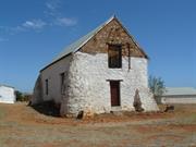
1993 Roof: Integrity: Low Modifications: Dismantled mine N/A The Baddera Mine site is located on the side of a gently rising hill and as such it is possible to get a slightly elevated and general overview to grasp the concept of the workings and function of the site. The site itself comprises extensive mine workings, tailing dumps, footings and concrete plinths, crushing equipment etc. left from one of the more recently operating (1950's) large mines in the district. There are also the ruins of stone and brick enclosures to buildings, and the base of a brick lined stone smelter chimney together with various scattered shafts and open pits. The mine has operated during various periods in the history of mining in the district and, being one of the more recently operating on some scale, has more interpretive material available to provide an understanding of the contribution mining made to the community. Baddera can also provide an example of more recent mining activity in comparison with the historic remnants of mining activity at the Wheal Fortune (Site No.35), Wheal Ellen (Site No. 117) mines and the State Battery (Site No. 88). About six miles north of Northampton, the Baddera Mine was discovered in 1873 and worked for several years to produce galena. During this time, Crowther and Mitchell obtained 176 tons of lead ore in 1878, 68 tons in 1879 and 374 tons in 1880. After being sampled by S. Cullingworth and being re-opened by the Fremantle Trading Company in 1907, its shaft was 347 ft deep in 1913, and No. two level was 800 ft long and No. three level was being driven. It was producing about 2200 tons of ore per month containing about 215 tons of lead. In 1915, stoping was being done over lengths of 630 ft at No. one level, 800 ft at No. 2 level, and 400 ft at No. three level. The Fremantle Trading company closed this mine in 1921, after working the main lode to a depth of 450 ft and a length of 1100 ft. By this date the mine had yielded 129.3 K tons of ore containing 13,890 tons of lead worth over 317 000 pounds. The mine was re-worked in the 1950s, and was closed in 1953 after two men were killed by a fall of rock. 2004 Baddera mine is 8km north of the township of Northampton and is reached by travelling 1.4 km east along Baddera Road and entering the wire gate at the south west corner of Location 1472. North Baddera Mine is some 500m north east of the Baddera, from which its tailings dump can be clearly seen. Vehicle access (4WD) between the mines is possible via a bushtrack and cleared exploration grid lines, but the North Baddera main shaft and treatment area are concealed by thick scrub and not easy to find. There is better vehicle access from a station track heading east from the main highway some 500m north of the Ladyland turnoff, but this is through private property. Baddera Mine With some notable exceptions, the evidence is that of the foundations of mining and treatment plant, the equipment having been removed for use at other sites after the mine's closure in the 1920s. The oldest structures at Baddera probably date from around 1906. Only the stone-work building-in of the Cornish boiler (no longer on site), and the foundations of its stack, remain from this period (NR037-1). Two or possibly three other periods of subsequent work are evident in the main shaft, treatment plant and boiler house areas. One includes the stonework building-in of the two existing Cornish boilers, the ducting of their flues to the older stack (NR037-4 to NR037-12), and the stonework plinths of crushers, tanks and Wilfley tables. These probably date from 1910, the beginning of the Baddera mine's most productive period which lasted to 1920. Concrete work in the last period mainly consists of plinths for Wilfley tables, treatment tanks and their motors. The general layout of the mine is with the steam generation plant at its centre, the main shaft, to the south and the treatment plant to the north. The flow direction of the treatment plant was from west to east, towards the tailings dump. The foundations of a fairly substantial house, possibly that of the mine manager, lie some distance away to the east. A roller crusher east of the main site (NR037-20 to NR037-21) was evidently not related to the original mine. Frenier pump spirals and drive In the north-west corner of the site are scattered 14 disk-shaped metal casings, some alongside a substantial machine drive. The casings, 4 ft (1.2m) diameter and 10 inches (250ml) deep, are formed of 5 ft (1,5ml) steel plate and contain within them a spiral of 6 turns at 55ml spacing (NR037-16 to NR037-18). The remnants match the description of a Frenier Pump. Roller crusher The crusher has been crudely mounted on a rock foundation (NR037-20 to NR037-21), now mainly collapsed. It is distant from the main treatment area and is almost certainly a remnant of a small scale, much later mining operation, possibly from the 1951-53 period. The 'house' The base of a stone-walled building survives in the eastern part of the site. Remains of two rooms are visible, one 2.6m x 4.9m wide, the other about 7m x 4.9m. This may have been a manager's residence, or it could have served a mine function such as storage, smithy or explosives magazine. Ventilation shaft This is a single compartment shaft, 1.8m x 0.8m, sawn timber lined with a bush timber collar. It has two 200ml timber stumps, 1.5m centres, near its south-western corner. Southern shaft Just outside the southern boundary of Location 1472 there is a deep pit that is being used as a rubbish tip. This corresponds to the southernmost shaft on the mine, noted by Feldtmann. North Baddera Mine Due to the isolated location of the mine, the remains of the North Baddera treatment plant have been well preserved apart from the ingress of the surrounding bush (NR037-29). While the North Baddera mine was operational several houses were built within Location 1472 to the west of the mine, and about 100m from it. The sites are now in very thick bush but traces of at least one can be identified. The treatment area is concrete floored throughout and was at least in part covered. From the mine shaft (NR037-23) the ore was raised to a bin. From the documentary evidence it is known that the ore was passed from the bin to a primary crusher, which was probably mounted on the H-shaped foundation near the Huntington mill (NR037-24); it was then fed via a trommel to the mill for fine grinding and thence over the Wilfley tables (NR037-27 to NR037-28) for mineral concentration. The Huntington mill (NR037-23 to NR037-25) is a pendulum (or centrifugal) mill in which suspended rollers crush the ore against a ring die. The remnant on site consists of the roller pendulum hanger ('spider' plate), central shaft, part of the ring die housing, timber bed and the drive shaft. Sparse remnants of habitation were noted some 70m east of the main shaft, but there was insufficient time to investigate these in detail.
Baddera Mines is situated on Location 1472, 8.8km north of Northampton and 1.6km east of the North West Coastal Highway. Two mines have been worked on the site, Baddera and Baddera North. These have also been known as Old Baddera and New Baddera, respectively. The southern extension of the Baddera ore body has been worked as the Baddera South mine. Baddera Mine was established in 1873 and worked for about ten years to a maximum depth of 30 metres. No production figures are available for this period but lead concentrates averaging 72% lead were produced to the value of £34,000. The mine was reopened and worked from 1910to 1921, during which time 14,110 tonnes of lead were produced from 131,340 tonnes of ore with an average grade of about 11% lead. This was the largest production of any lead mine in Western Australia. Baddera North was worked from 1948 to 1953 and yielded 730 tonnes of lead from 15,610 tonnes of ore with an average grade of approximately 5% lead. Key stages in the lives of the mines • First Phase of Mining 1873 c. 1900 • Mining for Smelter Flux 1900 - 1906 •The Change from Smelting to Lead Mining 1906-1910 •The First World War and the Lead Mining Boom • North Baddera Mine 1947-1953 •The January 1953 Mine Disaster •Two small 'shows' operated for short periods at Baddera,1951-53. • Ore from the Gurkha mine was processed at the North Baddera treatment plant, 1953-56. • G.H. Mitchell trucked tailings and hand-picked concentrates from the South Baddera dump for reprocessing at the Northampton State Battery, 1964-66 • During the base metals pegging boom the Baddera area pegged, 1970. for 'speculative purposes'. • Baddera and neighbouring areas drilled by Hillcrest Resources., 1997-98 Chronology Entries 1872 The Baddera Mine opened.
Integrity: Low Modifications: Dismantled mine Orig'l Fabric: Very little remains intact
Good
| Ref ID No | Ref Name | Ref Source | Ref Date |
|---|---|---|---|
| Wilson, R.C; "The Northampton Mineral Field". | Department of Mines, WA, | 1926 | |
| "Article". p.5 | Mining and Pastoral Register and Builders' Gazette, | 1 December 1921, | |
| "Lead Mines to Close". p. 15 | Mining and Pastoral Register and Builders' Gazette, | 1 February 1922, | |
| "Northampton Lead Mines, WA,". p. 447 | Chemical Engineering and Mining Review, | 5 September 1920, | |
| "Magazine Article". pp. 27-30 | Mining & Chemical Engineering Review, | 15 December 1965, | |
| Mining Manual & Mining Year Book, | 1914, to 1920. | ||
| Cumming, D.A; "Preliminary Notes on the Northampton Mineral Field". p.3 | 1993 | ||
| Montgomery, A. "Report on the Northampton Mineral Field" | Department of Mines, WA, | 1908 | |
| "Magazine Article". | Chemical Engineering and Mining Review, | 5 December 1921. | |
| Wray, C.H. Bewick Moreing; "Mining prospect inspection report". | Department of Minerals and Energy, WA. | 26 Feb.1907, | |
| MacGill, G. and Hartley, R.J; "A heritage assessment of the Baddera Mines, Northampton Mineral Field". | Heritage Council of Western Australia, | 2000 | |
| "Report". | Western Australian Dept of Mines Annual Reports | 1915, 1922. | |
| "Magazine Article". | Mining, Pastoral & Industrial Magazine, | 4 March 1919. | |
| Crabb, J; "Notes on the Mining Industry of Western Australia". p.5 | Mining and Pastoral Register and Builders Gazette | 1 December 1921, | |
| Hartley, R.G; "A History of Technological Change in Kalgoorlie Gold Metallurgy 1895-1915". pp. 117-121 | Murdoch University PHD | 1998 | |
| Gibb Maitland, A; "The Geological Features and Mineral Resources of Northampton". | GSWA Bulletin | 1909 | |
| Cullingworth, S; "Northampton" p.54 | Dept of Mines Annual Report | 1914 | |
| "Mining & Pastoral Register,". p.8 | 1 April 1920, | ||
| Berliat, K; "Report on the Northampton Mineral Field". pp. 27-30 | WAGS Annual Report | 1952 | |
| Feldtmann, F.R; "The Baddera lead mine, Northampton, South West Division". pp. 26-30 | WAGS Annual Report, | 1921 |
This information is provided voluntarily as a public service. The information provided is made available in good faith and is derived from sources believed to be reliable and accurate. However, the information is provided solely on the basis that readers will be responsible for making their own assessment of the matters discussed herein and are advised to verify all relevant representations, statements and information.
423 Starling Rd Bowes
Northampton
Midwest
Constructed from 1860
| Type | Status | Date | Documents |
|---|---|---|---|
| Heritage List | Adopted | 15 May 2020 | |
| State Register | Registered | 28 Jun 1996 | HCWebsite.Listing+ListingDocument, HCWebsite.Listing+ListingDocument |
| Type | Status | Date | Documents |
|---|---|---|---|
| (no listings) |
| Type | Status | Date | Grading/Management | |
|---|---|---|---|---|
| Category | ||||
| Aboriginal Heritage Sites Register | Permanent | |||
| Municipal Inventory | Adopted | 19 Apr 1996 | Category 1A | |
| Library Id | Title | Medium | Year Of Publication |
|---|---|---|---|
| 5644 | Oakabella Homestead : conservation works report. | Conservation works report | 2002 |
| 3430 | Oakabella Homestead : minor conservation works (Final Report). | Heritage Study {Other} | 1998 |
| 5753 | Homesteads of the mid west region of Western Australia. | Book | 1997 |
| 3999 | Oakabella Homestead Blacksmith's Shop Northampton : conservation works (Final Report). | Heritage Study {Other} | 1999 |
| 621 | Four homesteads: Oakabella, the Bowes (Knockbrack),Willi Gulli and Trevenson, Northampton District. | Heritage Study {Other} | 1995 |
| 5197 | Oakabella Homestead works, Geraldton WA : conservation works report. | Conservation works report | 2001 |
| 11950 | Oakabella Hall, Oakabella Homestead - Cyclone Seroja Structural Damage Report | 2022 | |
| 5921 | Off-shears : the story of shearing sheds in Western Australia. | Book | 2002 |
| 8331 | Oakabella homestead works 2006 - Geraldton WA. | Report | 2006 |
| 7778 | Heritage planning and management seminar 2004. | Loose-leaf | 2004 |
| 7829 | Oakabella estate 1851. | Brochure | 2005 |
| 3058 | Oakabella Homestead Barn : conservation works. | Heritage Study {Other} | 1997 |
| 11484 | Oakabella Bowes, Western Australia | Heritage Study {Cons'n Plan} | 2016 |
| 6485 | Oakabella Homestead : conservation works (final report). | Conservation works report | 2003 |
| 7409 | Oakabella Homestead : conservation works (final report). | Conservation works report | 2005 |
Individual Building or Group
| Epoch | General | Specific |
|---|---|---|
| Present Use | FARMING\PASTORAL | Homestead |
| Present Use | FARMING\PASTORAL | Shed or Barn |
| Original Use | FARMING\PASTORAL | Shed or Barn |
| Original Use | FARMING\PASTORAL | Homestead |
| Style |
|---|
| Vernacular |
| Victorian Georgian |
| Type | General | Specific |
|---|---|---|
| Wall | STONE | Local Stone |
| Roof | METAL | Corrugated Iron |
| General | Specific |
|---|---|
| PEOPLE | Early settlers |
| OCCUPATIONS | Grazing, pastoralism & dairying |
This information is provided voluntarily as a public service. The information provided is made available in good faith and is derived from sources believed to be reliable and accurate. However, the information is provided solely on the basis that readers will be responsible for making their own assessment of the matters discussed herein and are advised to verify all relevant representations, statements and information.
Constructed from 1860
The Oakabella Complex includes a homestead, a series of outbuildings (kitchen/dining buildings, barn, blacksmith's building, stables) and a shearing shed. Some outbuildings have been demolished or have fallen down. There is a large Moreton Bay Fig tree immediately north of the homestead, originally one of two such trees. Homestead: Simple longitudinal plan with rooms opening onto the verandah on the west side which in turn opens onto a walled garden. Low enclosed verandah on the east, possibly the original main internal access, but now partitioned off in places to form rooms. Main internal rooms have connecting doors to the north. Note the low height of door frames, particularly on the eastern access rooms. In general, the internal standard of finish is very simple. Some internal alterations have been undertaken that are not very sympathetic. External timber floors and verandahs have been removed and replaced by concrete. Construction generally rendered and white-washed stone walls with corrugated iron roof. Kitchen-Dining Building: Simple planning form, with L shaped kitchen and staff dining plus a separate room for the cook. Stone construction matching the house, with corrugated iron roof. Original timber framing of roof destroyed by cyclone, new gangnail timber-framing to replace original. Old roof sheeting refixed on the new framing. Note iron bars at window and corrugated iron verandah enclosure. The building is currently used for storage. Barn: Two storeyed stone barn with buttressed corners. Ground floor originally divided into two rooms; one with smooth, rendered walls, painted underside of floor above and fireplace. This room was used as a schoolroom at one stage. The other half of the ground floor was used for farm purposes and contained ladder access to the floor above. The dividing wall has since been removed along with the timber floor on the ground floor owing to a white ant infestation. Features of the building are the 9" Oregon timber planks and the stone buttressed corners which were added c1935 due to cracking in the structure. Early photographs of the barn depict it prior to the addition of the buttresses. [See Twentieth Century Impressions of Western Australia] Stables/Shearing Shed/Blacksmith's Shop: Generally stone construction, some soft brick construction of a later date. Simple timber framed roof with corrugated iron sheets, with some stamped Wolverhampton. Original stable areas have had timber grating floors added for shearing purposes, along with some sheet corrugated iron walls and lean-to's. Surrounding yards were built using timber sleepers retrieved from the Geraldton-Northampton railway. The Blacksmith's Shop, now in ruins after storm damage, has pigeon hojes to a loft still evident up at the top of the stone gable end.
The Oakabella pastoral lease, originally consisting of 50,000 acres of which 8,000 were freehold, was initially taken up by James Drummond in the mid 1850s. The Oakabella Homestead, which stands on the Oakabella River, has been continuously lived in since its construction. The west end of the shearing shed, which still houses much original equipment, was originally used as stables for race horses and horse breeding for the Indian Raj. In 1871 James Drummond, whose brother John Drummond took up the White Peak pastoral lease, sold Oakabella to Lockier Burges Jnr. The property was later purchased by S.R.L. Elliot who also owned the adjoining Yarra property (site No. 148). The homestead is situated close to the route of the Geraldton-Northampton railway line which was constructed in 1879; indeed there was a siding located on the property. Like the other pastoral ieases in the region, Oakabella was purchased by the government for closer settlement around the turn of the century. Since then the property has been greatly subdivided. Over the years many social dances have been held in the barn, which was also used as a school (For details about the school, see My Life by S. Bridgeman pp.7-22): The property currently operates as a tourist venture with a cafe, guided tours of homestead and market days etc. Chronology Entries 1852 Samuel Sewell became managing partner of the Yarra and Oakabella leases.
Integrity: High Modifications: See description below Orig'l Fabric: See description below
| Ref ID No | Ref Name | Ref Source | Ref Date |
|---|---|---|---|
| Considine & Griffiths; "The Four Homesteads". | 1994 | ||
| GHS5365 | Photograph; "harvesting". | Northampton Historical Society, | 1908 |
| "Newspaper Article". | Geraldton Express | 24/11/1899. | |
| Feilman & Associates, "A Survey of Places of Historic and Landscape Significance in Northampton, Dongara, Geraldton, WA", | 1977 | ||
| "Homestead transformed" | Geraldton Gaurdian | 1/09/1997 | |
| "Twentieth Century Impressions of Western Australia,". | |||
| "Listing for Oakabella" | Geraldton Gaurdian | 12/01/1996 | |
| "New Life for 1850s Northampton Gem" | West Australian | 16/09/1999. | |
| BL Acc 994.12 | Bain, M.A; "Ancient Landmarks: A Social and Economic History of the Victoria District of Western Australia, 1839-1894". | UWA Press | 1975 |
This information is provided voluntarily as a public service. The information provided is made available in good faith and is derived from sources believed to be reliable and accurate. However, the information is provided solely on the basis that readers will be responsible for making their own assessment of the matters discussed herein and are advised to verify all relevant representations, statements and information.
Oakabel/a, comprising: homestead and associated walled garden and trees; a kitchen and quarters; two storey barn; blacksmith 's shop (ruin); stables; shearing shed; and two framed houses with various modem light-framed shelter structures, has cultural heritage significance for the following reasons: the place has aesthetic value as a unified group of farm buildings set in the landscape; the place is representative of a phase of agricultural development of the State and the Northampton District; the place makes a contribution to the community 's sense of place; and, the place has rarity as a relatively complete example of its type. ASSESSMENT OF SIGNIFICANCE Aesthetic Value Oakabella operates as a coherent visual whole and the stone structures contribute to the aesthetic hannony of the group and create visual complexity. The buildings, individually, are simple structures which contribute to the whole. Oakabella is particularly important in the way it relates to the land and local climatic conditions, and demonstrates a culturally modified landscape associated with the buildings. Together with Knockbrack (The Bowes), Willi Gu/Ii and Trevenson homesteads, Oakabella is one of a group of farm homesteads of a similar type and construction, in close proximity to each other in the Northampton district. Scientific Value With particular reference to the shearing shed, Oakabella has a capacity to contribute to the wider understanding of aspects of the human occupation of the district because of the intact shearing layout, pens and equipment. Social Value As a large and substantially intact homestead of the mid-nineteenth century, Oakabella makes a contribution to the community's sense of place.
Oakabella, comprising: homestead and associated walled garden and trees; a kitchen and quarters; two storey barn; blacksmith 's shop (ruin); stables; shearing shed; and two framed houses with various modem light-framed shelter structures.
Assessment 1997 Construction 1860's
This information is provided voluntarily as a public service. The information provided is made available in good faith and is derived from sources believed to be reliable and accurate. However, the information is provided solely on the basis that readers will be responsible for making their own assessment of the matters discussed herein and are advised to verify all relevant representations, statements and information.
1950 Nabawa East Bowes
Chilimony Bowes
Knockbrack
Northampton
Midwest
Constructed from 1850
| Type | Status | Date | Documents |
|---|---|---|---|
| Heritage List | Adopted | 15 May 2020 | |
| State Register | Registered | 06 Sep 1996 | HCWebsite.Listing+ListingDocument |
| Type | Status | Date | Documents |
|---|---|---|---|
| (no listings) |
| Type | Status | Date | Grading/Management | |
|---|---|---|---|---|
| Category | ||||
| Municipal Inventory | Adopted | 19 Apr 1996 | Category 1A | |
| Library Id | Title | Medium | Year Of Publication |
|---|---|---|---|
| 5753 | Homesteads of the mid west region of Western Australia. | Book | 1997 |
| 11712 | The Bowes (Knockbrack) Northampton, Western Australia | Heritage Study {Cons'n Plan} | 2019 |
| 9407 | The Bowes - final report. | Conservation works report | 2009 |
| 621 | Four homesteads: Oakabella, the Bowes (Knockbrack),Willi Gulli and Trevenson, Northampton District. | Heritage Study {Other} | 1995 |
| 7146 | The Bowes, Northampton, Western Australia : conservation works (final report). | Conservation works report | 2004 |
Individual Building or Group
| Epoch | General | Specific |
|---|---|---|
| Original Use | FARMING\PASTORAL | Homestead |
| Original Use | FARMING\PASTORAL | Shed or Barn |
| Present Use | FARMING\PASTORAL | Homestead |
| Style |
|---|
| Victorian Georgian |
| Type | General | Specific |
|---|---|---|
| Wall | STONE | Other Stone |
| Roof | METAL | Corrugated Iron |
| Wall | RENDER | Cement Dressed |
| General | Specific |
|---|---|
| OCCUPATIONS | Grazing, pastoralism & dairying |
| PEOPLE | Early settlers |
This information is provided voluntarily as a public service. The information provided is made available in good faith and is derived from sources believed to be reliable and accurate. However, the information is provided solely on the basis that readers will be responsible for making their own assessment of the matters discussed herein and are advised to verify all relevant representations, statements and information.
Constructed from 1860
'The Bowes' Estate, its homestead, associated outbuildings and cemetery, is highly significant historically, socially and aesthetically for the role the property and its owners have played in the pioneering and development of the region and the State. The homestead buildings, shearing shed and cemetery are particularly significant for their condition, influence on similar buildings in the district and the important role the people associated with them have played both locally and throughout the State.
The Bowes Homestead is located on the Bowes River approx. 10 kms south east of Northampton on the Northampton - Nabawa Road. The homestead has a long rectangular floor plan, one room wide with lean-to enclosures to the rear and a long open verandah facing the river. The verandah is supported on timber posts and is an extension of the main, hipped, CGI roof over the homestead. French doors open from each room onto the verandah to catch the breeze and provide access. Originally, access between most rooms was gained using the verandah as an external 'passageway', although there appears to have been some direct access between several rooms as there is now. This was a common design format for the early homesteads of the period and it is said ' The Bowes', being the first, formed a model for the other large pastoral homesteads of the district such as Oakabella (Site No. 147) There are a collection of outbuildings adjacent to the homestead including the original separate kitchen and dining room with painted rendered stone walls (possibly originally limewashed) located off the rear verandah (now enclosed). These buildings now appear to be used as staff accommodation and provide something of a quadrangle around the back of the homestead which could have been intentional for security against aboriginal attack or ease of access. A little further away there is also a more recent managers house and several metal clad farm sheds. On the other side of the river from the homestead is a large, white painted, stone shearing shed with CGI roof. The shearing shed is elegantly proportioned with tall internal spaces punctuated with timber columns supporting the roof. It is located just off the Northampton-Nabawa Road near to where a railway siding, on the Geraldton- Northampton government line, originally serviced The Bowes. Further upstream from the homestead, and on the same side of the river is a small family cemetery. A stone retaining wall along the river bank to minimise the affects of flooding. The cemetery contains the graves of pioneer settlers and several prominent headstones remain intact. Fortunately, the graves have been protected from stock by a steel fence which although functional is too confining and somewhat unsympathetic in its design.
William Burges was the first permanent land settler in the Northampton District, establishing the first pastoral property there in 1850. Burges was born in 1807 in the little Irish town of Tipperary. In 1830 William, along with his brothers Samuel and Lockier Burges, arrived at Fremantle on the 'Warrior'. After their arrival the government made a grant of 1920 acres of land along the Swan River to William, the eldest of the three brothers. A little later a further grant of 3000 acres on the Avon River was made, followed by another 6000 acres. This property was named 'Tipperary' after their home town in Ireland. In 1848 Lockier Burges, the youngest of the three brothers, accompanied the A.C. and F.C. Gregory expedition which penetrated as far north as the Murchison River and confirmed the rich pastoral prospects of the land between the Irwin and Murchison Rivers. On his return to the York property Lockier Burges emphasised to his brothers the suitability for grazing of that country. Messrs William Burges and John Drummond visited the Geraldine Mine in November 1849, while at the same time evaluating the land thereabouts for pastoral potential. Both Burges and Drummond were impressed by what they saw. Consequently, in 1850 both William and Lockier Burges left 'Tipperary' and set off for the Champion Bay district with 2000 sheep and 200 head of cattle. The brothers were met at Dandaragan by Augustus and Henry Gregory who acted as guides while John Drummond went along as police escort of what became the town of Northampton, where William and Lockier took up a pastoral lease of 132 000 acres. Initially calling the property' Knockbrack' after his old home in Ireland, William eventually renamed the estate 'The Bowes' because of its position on the Bowes River. The Bowes was widely known as the centre of hospitality for those passing through the district. John Forrest, on his epic journey to Adelaide in 1874, wrote of the "hospitable residence of Thomas Burges. When the Geraldton-Northampton Railway was constructed 1874-1879, a siding was located at 'The Bowes', a quarter of a mile from the homestead. In July 1900 the partnership of WM & SL Burges was dissolved and the 100,000 acre lease was put up for sale. Bowes and Yuin were purchased by William Burges for 30,000 pounds in December 1900. In the early 1900s the Government made a decision not to renew pastoral leases in the area and much of The Bowes' was resumed and subdivided into 600 and 1000 acre farms. Many other large pastoral properties in the Victoria district, including Oakabella, Mt Erin and Narra Tarra, suffered the same fate. The Bowes Estate was reduced to 16 927 acres and in 1911 Thomas Drage purchased from the property from the Burges family. Elizabeth Drage, widow of Thomas Drage sold The Bowes in 1940 to the Lee Steere family who still control the property. As the first pastoral property in the Northampton District, The Bowes is representative of both the pastoral and agricultural industries as well as the significant influence of the Burges family in the development of the area. The private cemetery on the bank of the Bowes River contains the graves of members of this pioneer family. Chronology Entries 1850 William Burges moved from the Avon Valley to Champion Bay and established a pastoral tease called 'The Bowes'. Source Pages Ancient Landmarks, Bain, M. A., UWA Press, Perth, 1975 ISBN:0 85564 090 1 46 1853 William Burges wrote to the Governor, without success, seeking consideration for the right to crop land without tillage lease or payment of rent, and a lifting of the restrictions regarding the size and shape of cultivated paddocks. 1866 E. T. Hooley trekked from Champion Bay to Pt Walcott seeking a stock route. Source Pages E. T. Hooley, Pioneer Bushman, Sharp, E. I.„ 1985 ISBN:0 9588829 0 8 1874 John and Alexander Forrest's exploration party passed through the Northampton area amidst enthusiastic celebrations.
Integrity: High Modifications: Some enclosures and alterations Orig'l Fabric: Mostly intact
Good
| Ref ID No | Ref Name | Ref Source | Ref Date |
|---|---|---|---|
| "Fire guts historic cottage" | Geraldton Guardian | 14/02/1996. | |
| BL Acc 1133 B/45 | Photograph; "Bowes" Station showing the homestead owned by William Burges,". | Battye Library | 1900 |
| BL Acc 4010 B, c.r. 67714 P - 6716 P | Photograph: "the Bowes' Homestead,,". | Battye Library | 1927 |
| BL Acc 3379 B | Photograph; "the Bowes' Homestead, front view,e". | Battye Library | 1967 |
| BL Acc 994.12 | Bain, M.A; "Ancient Landmarks: A Social and Economic History of the Victoria District of Western Australia, 1839-1894". | UWA Press | |
| BL Acc 816 BIB 509-510 | Photograph: "the Bowes' Homestead,,". | Battye Library | 1929 |
| Feilman & Associates; "A Survey of Places of Historic and Landscape Significance in Northampton, Dongara, Geraldton, WA", | 1977 | ||
| Considine & Griffiths; "The Four Homesteads" | 1994 |
| Owner | Category |
|---|---|
| Lee Steere Pty Ltd | Other Private |
This information is provided voluntarily as a public service. The information provided is made available in good faith and is derived from sources believed to be reliable and accurate. However, the information is provided solely on the basis that readers will be responsible for making their own assessment of the matters discussed herein and are advised to verify all relevant representations, statements and information.
off Warribanno Chimney Rd Galena
Situated on the Murchison River about 5 km downstream from the Murchison River Bridge on the North West Coastal Highway. Original workings on N bank also shafts in river. Newer workings on S side of river. Inc Kilally (Coolally) homestead and graveyard north of the mine site.
Geraldine Mine Site, Buildings and Graveyard
Northampton
Midwest
Constructed from 1849 to 1960
| Type | Status | Date | Documents |
|---|---|---|---|
| Heritage List | Adopted | 15 May 2020 | |
| State Register | Registered | 04 Aug 1998 | HCWebsite.Listing+ListingDocument, HCWebsite.Listing+ListingDocument |
| Type | Status | Date | Documents |
|---|---|---|---|
| (no listings) |
| Type | Status | Date | Grading/Management | |
|---|---|---|---|---|
| Category | ||||
| Aboriginal Heritage Sites Register | Interim | |||
| Register of the National Estate | Indicative Place | |||
| Municipal Inventory | Adopted | 19 Apr 1996 | Category 1A | |
15875 Galena Heritage Area
| Library Id | Title | Medium | Year Of Publication |
|---|---|---|---|
| 6322 | The technology of colonial ore processing in Western Australia : the Warribanno Lead Smelter. | Journal article | 1997 |
| 9051 | Galena mine field archaeological report. | Heritage Study {Other} | 2008 |
| 11815 | Henderson & Coy : Royal Engineers & the Convict Establishment Fremantle Western Australia 1850 - 1872 | Book | 2017 |
| 11569 | Landscapes of Redemption: Tracing the path of a Convict Miner in Western Australia | Heritage Study {Other} | 2010 |
| 2398 | National Estate Program : documentation of geological sites and monuments; Nomination of geological monument for the register of the National Estate: Dingo Gap, Bugle Gap, Bringo Railway cutting, Molecap Hill, Veevers Crater, Dalgaranga Crater, North Pole, | Report | 1989 |
| 3845 | Galena Mining Heritage : conservation plan. | Heritage Study {Cons'n Plan} | 1998 |
Other Built Type
| Epoch | General | Specific |
|---|---|---|
| Original Use | MINING | Other |
| Present Use | VACANT\UNUSED | Vacant\Unused |
| Style |
|---|
| Other Style |
| General | Specific |
|---|---|
| DEMOGRAPHIC SETTLEMENT & MOBILITY | Resource exploitation & depletion |
| DEMOGRAPHIC SETTLEMENT & MOBILITY | Settlements |
| OCCUPATIONS | Mining {incl. mineral processing} |
This information is provided voluntarily as a public service. The information provided is made available in good faith and is derived from sources believed to be reliable and accurate. However, the information is provided solely on the basis that readers will be responsible for making their own assessment of the matters discussed herein and are advised to verify all relevant representations, statements and information.
Constructed from 1849
1993 The site is very significant historically and scientifically for its role in the development of the region and the beginnings of mining in Western Australia. 2004 Geraldine Lead Mine, an archaeological and geological site with ruins and machinery remnants, has cultural heritage significance for the following reasons: •the Mine was the first commercial mining venture in Western Australia; •the Mine represents the early aspirations of the Swan River colony for economic independence; •the place contains ruins of some of the oldest buildings in the region and as such, it has the potential to yield invaluable information about how early settlers coped with living in an isolated environment and how they lived during this period. The place also contains remnants of mine shafts, machinery (including parts of an early steam traction engine), engine houses, knapping or ore-breaking floor, mine manager's house (Collally), cemetery and ore processing remains; •the Mine, together with early pastoral activity, was responsible for opening up the Murchison and Victoria districts and led to the establishment of Geraldton (Champion Bay) and Port Gregory; •the ore breaking floor and the arrangement of compounds and associated buildings have not been found on other mining sites in Western Australia; •the place contains vital information about early mining practices in the state of Western Australia; •the Mine is socially important for the people of Northampton who identify the site as an important component of their local heritage; as part of a cultural landscape, the place has aesthetic value due to its location on the banks of the Murchison River; and, •the place is associated with the convict period of history, convict labour and the important archaeological site at the failed convict hiring depot at Lynton, with which it shares a common history.
1993 Site and ruins of the first lead mine in the State. Ruins north of the river include the mine office and manager's house and the Knapping floor. On the south bank are the remains of further buildings, possibly miners accommodation. (Carter, J.D. 1987, Important Geological Localities in Western Australia.) The stone walls of a large building (thought to be the engine room-ref Cumming, D.) associated with the mine still stand adjacent to the stone paved ore breaking floor alongside the river. The building appears to have the remnants of mountings built into the floor for some sort of equipment. A low stone wall provides a small fenced paddock on one side of the building. Some industrial archaeological examination would assist in identifying various components of the site. There are also collapsed and filled tunnels, and mine workings underground. Fifty metres to the north are the stone ruins of the Kilally buildings, walled paddocks and a cemetery (see Site No. 8). 2004 For the full description see the Heritage Council Register documentation. See also Gibbs 1998. The oldest structures on the site are located on slightly elevated ground on the western side of the Murchison River. These comprise the Engine House and associated compound, ore breaking floor, Mine Manager's House and compound and the cemetery. The 1960s ore processing site is located on rising ground on the eastern side of the river. The structures on the eastern side of the river are located in a cleared area with some re-growth of natural vegetation, surrounded by mullock heaps. The Engine House is constructed from random rubble laterite stone walling held together with mud mortar. The southern wall is the most intact wall and is punctuated with two window openings either side of a centrally located door. Timber lintels are still insitu. A large portion of the eastern wall remains and is punctuated with one window opening. There is no evidence of flooring material or roofing members, although there is evidence of two raised sections of flooring or engine mountings at the eastern end of the building. North of the building, are the remains of stone walls which appear to have formed an enclosed compound (with the Engine House forming the southern boundary), together with small rooms opening into the compound. These rooms are located along the northern and eastern walls of the compound. During the current survey no artifactual scatters were noted, although the remains of a boiler were found abandoned in the compound. No determination was made as to whether this was part of the steam traction engine mentioned in the documentary evidence. On the southern side of the Engine House is the ore breaking floor. This area has been carefully levelled and laid with stones. Portions of the floor have fallen away on the western and southern sides. Foundations were also noted for other buildings/structures located between the knapping floor and the Engine House, on the southern edge of the floor and also on the western side of the floor. The Mine Manager's House is located north of the Engine House and is constructed in a similar fashion, laterite stone walls with finished joints, and lime applied to the exterior and interior wall surfaces. The walls are in a more ruinous condition than those of the Engine House. This building also has a large compound enclosed by a stone wall. Like the Engine House compound, small rooms appear to have been constructed within the compound corners. A stone cairn, erected by the CWA in 1979, is located in the middle of the compound. The cemetery is located slightly to the north of the Mine Manager's House. The historical record indicates that other buildings, dating from the original workings (1851), were located on the eastern side of the river. The ore processing remains on the eastern side of the river date from the 1960s when the mine was briefly reopened. These remains consist of concrete aprons together with concrete foundations and steel frameworks (Photos NR007-02 to NR007-4). Adjacent to the concrete aprons are numerous mullock heaps which appear to be chronologically related to the concrete and steel structures. Fifty metres to the north are the stone ruins of the Kilally buildings, walled paddocks and a cemetery (see Site No. 8).
1993 Mr Walcott, a member of the Gregory exploration party of 1848, found some specimens of galena (lead ore) in the bed of the Murchison River. Further investigation revealed that the lead existed in abundant quantities. Following an examination of the site by the Governor, His Excellency Charles Fitzgerald, he enthusiastically encouraged the exploitation of the lead finds. As a result the Geraldine Lead Mine, under the control of Mr Lockier C. Burges, began operations in 1849. The Geraldine Mining Company arranged for F. Pearson to build a smelting works nearby, the chimney of which still stands. (Site No. 9). Mine Captains at the Geraldine included L.C. Burges in 1849, Capt. James in 1850, Martin Hosken in 1853 and Samuel Mitchell between 1867 and 1875. The flooding of the Murchison River on several occasions, the hazards of Port Gregory for shipping and the fluctuations of the world mineral market resulted in the mine enjoying mixed fortunes. Abandoned in 1875, the Geraldine was reopened in 1910 and over the following 12 years, yielded 774 tons of ore containing 275 tons of lead worth 5739 pounds. 2004 For the full history see the Heritage Council Register documentation. See also Gibbs 1998. The place is composed of a number of structures, some of which are not fully documented at present. To date, structures identified on the site include: the Engine House (c.1851), Mine Manager's House (c.1851), Ore breaking floor (c.1851), Cemetery (c.1854), Mine Shafts (1849), and the Ore processing site (c.1960s). In 1846, Augustus Gregory, then a member of the Colonial Government's Survey Department, had discovered brown coal along the Irwin River in the previously unexplored mid-west region of Western Australia. In 1848, Gregory, together with his brother Charles and a group of settlers including pastoralist Lockier Burges, made a second expedition northward, discovering galena (lead sulphide) in the bed of the Murchison River, as well as viable pastoral land along the Bowes River. After several months during which the land failed to sell, an auction was held and 640 acres acquired by the newly founded Geraldine Mining Company, the first of several companies to bear the name. As the mine site was far removed from the relative safety of Perth, the government initially provided the enterprise with a detachment of 25 soldiers and a promise to establish a boat harbour (Champion Bay) to facilitate the shipment of the ore. Under the direction of Lockier Burges, operations commenced at the mine in December 1849 and the first shipment of 5 tons of ore was brought back to Champion Bay on the 22 December. Lockier Burges, who was unhappy with the location of the mine shaft in the river bed, left as mine manager in 1850 and was replaced by Captain James. It was soon realised that it would be more efficient to transport smelted lead for shipment and in 1851, Francis Pearson, an experienced smelter from Newcastle-upon-Tyne, arrived from England with his family. He immediately set about constructing a temporary trial smelter at Geraldine Lead Mine. In 1853, yet another mine manager was appointed, Martin Hoskin. He complained that the mine was not as productive as it might have been due to years of mis-management and inadequate equipment. Over the years the Blue Books record the amount of lead extracted from the mine which appears to have been quite productive, although due to the unusual location of the mine in the bed of the Murchison River, operations were often interrupted when the river flooded. Progress over the following years can be traced through the annual Blue Book reports, which indicate a fluctuating production between 1853 and 1860, varying from 55 to 134 tons per annum. Although there is information about the lead yields from Geraldine Lead Mine, there is little documentary evidence relating to the actual structures built on the site or the numbers of men employed there or their living conditions. However, the number of convicts and ticket-of-leave men employed on the site is recorded. The mining company managed to obtain 60 men from Cornwall and the North Country who were experienced miners. In 1856, Geraldine Lead Mine was offered for sale and the prospectus that was prepared for this sale offers tantalising information about the site. Pumps and machinery are put up, but a small engine will be necessary, in order to do away with the costly horse-power at present employed Good cottages, stores, smithy, and all necessary buildings connected with the mine, are erected Between 1860 and 1863, the Blue Books list Geraldine Lead Mine as 'not working'. Under the ownership of Robert Habgood, mining recommenced in 1864/65 and in 1866 Habgood brought out Cornishman Samuel Mitchell, an experienced mine manager. This was Geraldine Lead Mine's most productive phase which lasted until 1878, when Habgood died, leaving the estate entailed. Geraldine Lead Mine did not open again until 1917. During 1917-1918 the Geraldine was briefly worked by Harry Gallagher, and during the 1960s the Mine was purchased by Joe Plaistow; however, the shafts were not extensively worked. During this brief period of occupancy, a lead ore processing site was constructed on the eastern side of the Murchison River. Geraldine Lead Mine has effectively lain idle since this time. During the early occupancy of the place, a cemetery was established which contains four headstones dating from 1854 to 1870. Chronology Entries 1848 An exploration party lead by A. C. Gregory found lead ore on the banks of the Murchison River and good pastoral country in the hinterland of Champion Bay, at the Hutt and Bowes Rivers. 1849 The Murchison River was classified as mineral land and the Geraldine Mining Company was founded with Lockier Burges as the Mine Manager. The Geraldine Mine is believed to have been one of the first mines in Australia. The first lead was exported from the Geraldine Mine. Source Pages Ancient Landmarks, Bain, M. A., UWA Press, Perth, 1975 ISBN:0 85564 090 1 34 1851 Francis Pearson, a smelter tradesman, his wife Mary Anne and their family settled near the Geraldine Mine area. For the next five years, the Pearsons were the only European family living in the locality. Pearson built the smelters to service the Geraldine Mine. The Warribanno Chimney was completed. 1851 Governor Hampton offered the people of the Geraldine mine a wooden house and the protection oi 25 soldiers. 1851 22 ticket-of-leave men were working at the Geraldine Mine and with Government Surveyors in the district. 20/11/1854 Surveyor Robert Austin and party arrived at the Geraldine Mine after an exploratory trip to tine north and east of the settled districts. 1866 E. T. Hooley trekked from Champion Bay to Pt Walcott seeking a stock route. Source Pages E. T. Hooley, Pioneer Bushman, Sharp, E. I.„ 1985 ISBN:0 9588829 0 8 1867 Captain Samuel Mitchell arrived from Cornwall to manage the Geraldine Mine.
Integrity: Low Modifications: Dismantled Mine
Poor
| Ref ID No | Ref Name | Ref Source | Ref Date |
|---|---|---|---|
| Bain, M.A; "Ancient Landmarks". | UWA Press | 1975 | |
| Gibbs, M; "A preliminary archaeological survey of the Geraldine Lead Mine, Ajana Western Australia. Northampton Archaeological Survey". | Dr Martin Gibbs and the Archaeological Society of Western Australia, unpublished | 1997-98 | |
| Clydesdale, J; "Fuel tank clue to Australia's first roadtrain". | Sunday Times | 13/9/1995 | |
| Lowrie, J; "Notes for C.W.A. Radio Sessions on 6GE". | Unpublished | 1979 | |
| Considine & Griffiths; "Warribanno Lead Smelter Complex; Conservation Plan". | Considine & Griffiths | ||
| Kelly, G. J; "History of Mining in the Geraldton District' in Early Days". Vol. 8, Pt 1, | 1962 | ||
| Considine & Griffiths; "Lynton Heritage Conservation Plan". | Considine & Griffiths | ||
| Carter, J.D; "Important Geological Localities in Western Australia." | 1987 | ||
| Cumming, D; "Preliminary Notes on the Northampton Mineral Field". | 1994 | ||
| Considine & Griffiths; "Warribanno Lead Smelter Complex'". | Considine & Griffiths | 1995 | |
| Galena Management Plan Steering Committee; "Galena Mining Heritage Area Management Plan". | Shire of Northampton. | ||
| Lowth, S; "A History of the Geraldine Lead Mine' Australian Studies III". | Unpublished | ||
| Kelly, G. J; "History of Mining in the Geraldton District' in Early Days". Vol. 6, Pt 1, | 1962 |
This information is provided voluntarily as a public service. The information provided is made available in good faith and is derived from sources believed to be reliable and accurate. However, the information is provided solely on the basis that readers will be responsible for making their own assessment of the matters discussed herein and are advised to verify all relevant representations, statements and information.
Gwalla St Gwalla
Northampton
Midwest
Constructed from 1863
| Type | Status | Date | Documents |
|---|---|---|---|
| (no listings) |
| Type | Status | Date | Documents |
|---|---|---|---|
| (no listings) |
| Type | Status | Date | Grading/Management | |
|---|---|---|---|---|
| Category | ||||
| Municipal Inventory | Adopted | 19 Apr 1996 | Category 1A | |
| Municipal Inventory | Adopted | 19 Apr 1996 | Category 1A | |
01902 Church & Cemetery, Gwalla
Landscape
| Epoch | General | Specific |
|---|---|---|
| Original Use | MONUMENT\CEMETERY | Cemetery |
This information is provided voluntarily as a public service. The information provided is made available in good faith and is derived from sources believed to be reliable and accurate. However, the information is provided solely on the basis that readers will be responsible for making their own assessment of the matters discussed herein and are advised to verify all relevant representations, statements and information.
Constructed from 1863
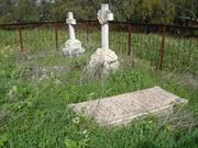
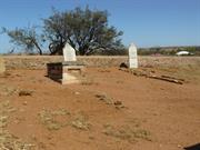
The Gwalla Cemetery is significant socially and historically as the first interdenominational cemetery in Northampton as well as for its associations with prominent people buried there. It is an integral part of the Gwalla Precinct, which includes the adjacent Gwalla Church, the mine site, ruins of Horrocks' stone walls, the site of the first railway station, stone cottage ruins, as well as stone and CGI miners' cottages.
The walled cemetery has 1.2m (4ft) high stone perimeter walls that sweep up high to pillars either side of timber entry gates. The walls have been built in Horrocks' style [See Site No. 137], but with smooth rendered capping. Attempts have been made to stabilise walls by renovating capping, unfortunately using grey cement which is unsympathetic to the natural stone and capping. There are an interesting variety of headstones and fencing styles to graves. One of the most significant marked graves is Horrocks', with a brick tomb above the ground.. A stone obelisk just inside the entry gates commemorates the early pioneers and was unveiled by the Honourable David Brand in 1964.
The Gwalla Cemetery, the oldest of the three cemeteries in Northampton was opened for burial in 1861. Like the Gwalla Church, the cemetery was non-sectarian and contains the graves of many early pioneers, including 'Dr' Joseph Horrocks, Captain Samuel Mitchell, his wife and son. Mitchell was a manager at the Geraldine Mine [Site No. 7], before living at Chiverton House [Site No. 107] Martin Hosken is also buried in the cemetery. He was the owner of the Mining Arms [Site No. 60] and the Railway Hotel [Site No. 104]. Chronology Entries 07/10/1865 Death of Joseph. Horrocks at the age of 55. 07/1912 Death of Captain Samuel Mitchell.
Integrity: Low
Fair
| Ref ID No | Ref Name | Ref Source | Ref Date |
|---|---|---|---|
| BL Acc 4396 B/18 | Photograph: "Memorial at Gwalla Cemetery,". | Battye Library | 1969 |
| GHS3925 | Photograph; "memorial". | Northampton Historical Society, | 1964 |
| BL Acc 994.12 | Bain, M.A; "Ancient Landmarks: A Social and Economic History of the Victoria District of Western Australia, 1839-1894". | UWA Press | 1975 |
| Drew, J.M., "Early Northampton: An Undenominational Church", Early Days, Vol.2, No. 2. | 1932 | ||
| Considine and Griffiths Architects Pty Ltd; "Gwalla Precinct, Northampton Conservation Plan". | Shire of Northampton | 200 | |
| Palassis; "Northampton Character Study". | |||
| Considine & Griffiths Architects Pty Ltd; "Gwalla Cemetery Preliminary Conservation Report" | Shire of Northampton | 1998 | |
| Feilman & Associates, "A Survey of Places of Historic and Landscape Significance in Northampton, Dongara, Geraldton, WA", | 1977 |
| Owner | Category |
|---|---|
| Shire of Northampton | Local Gov't |
This information is provided voluntarily as a public service. The information provided is made available in good faith and is derived from sources believed to be reliable and accurate. However, the information is provided solely on the basis that readers will be responsible for making their own assessment of the matters discussed herein and are advised to verify all relevant representations, statements and information.
Grey Rd Lynton/Port Gregory
Northampton
Midwest
| Type | Status | Date | Documents |
|---|---|---|---|
| (no listings) |
| Type | Status | Date | Documents |
|---|---|---|---|
| (no listings) |
| Type | Status | Date | Grading/Management | |
|---|---|---|---|---|
| Category | ||||
| Municipal Inventory | Adopted | 19 Apr 1996 | Category 4A | |
01915 Lynton Convict Hiring Depot (Ruins)
Historic Site
| Epoch | General | Specific |
|---|---|---|
| Present Use | INDUSTRIAL\MANUFACTURING | Other |
| Original Use | INDUSTRIAL\MANUFACTURING | Other |
| General | Specific |
|---|---|
| DEMOGRAPHIC SETTLEMENT & MOBILITY | Settlements |
| OCCUPATIONS | Manufacturing & processing |
This information is provided voluntarily as a public service. The information provided is made available in good faith and is derived from sources believed to be reliable and accurate. However, the information is provided solely on the basis that readers will be responsible for making their own assessment of the matters discussed herein and are advised to verify all relevant representations, statements and information.
The site of the lime kilns and quarry may have some local historic and scientific significance as an early secondary industry and in its role in the development of the district.
The lime kiln site, with a quarry also in a similar locale, is located nearby the ruins of the Pensioner Guard cottages. The lime kiln is a rough circular shape of about 3.9m diameter with standing walls of about 0.9 to 0.68m thickness, with a draught hole opening in the south-west side of the circle. The circle is built partly into the slope of the hill to assist easy loading.
The lime kiln & quarry is believed to have been used in the construction of the various buildings which made up the Lynton Hiring Depot (Site No. 25), Sanford's House (Site No. 26) and the Pensioner Guards Cottages (Site No. 27). The lime kiln is mentioned in the inspection report of April 1854.
Integrity: Low
Poor
| Ref ID No | Ref Name | Ref Source | Ref Date |
|---|---|---|---|
| GHS5514 | Photograph; "Lime Kiln". | 1942 | |
| GHS5888 | Photograph; "Lime Kiln". | 1940 | |
| GHS3054 | Photograph; "Lime Kiln". | Undated | |
| GHS6195 | Photograph; "Lime Kiln". | 1972 |
This information is provided voluntarily as a public service. The information provided is made available in good faith and is derived from sources believed to be reliable and accurate. However, the information is provided solely on the basis that readers will be responsible for making their own assessment of the matters discussed herein and are advised to verify all relevant representations, statements and information.
Northampton
Mary Street Station
Northampton
Midwest
| Type | Status | Date | Documents |
|---|---|---|---|
| (no listings) |
| Type | Status | Date | Documents |
|---|---|---|---|
| (no listings) |
| Type | Status | Date | Grading/Management | |
|---|---|---|---|---|
| Category | ||||
| Municipal Inventory | Adopted | 18 Nov 2005 | Category 1B | |
| Municipal Inventory | Adopted | 19 Apr 1996 | Category 1B | |
01911 Northampton Railway Station Precinct
| Library Id | Title | Medium | Year Of Publication |
|---|---|---|---|
| 9402 | Northampton Railway Station | Heritage Study {Cons'n Plan} | 2009 |
Individual Building or Group
| Epoch | General | Specific |
|---|---|---|
| Original Use | Transport\Communications | Rail: Railway Station |
This information is provided voluntarily as a public service. The information provided is made available in good faith and is derived from sources believed to be reliable and accurate. However, the information is provided solely on the basis that readers will be responsible for making their own assessment of the matters discussed herein and are advised to verify all relevant representations, statements and information.
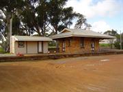
Whilst the Northampton Railway Station site is not the first site for the railway station it is significant as the site of the only remaining buildings north of Geraldton on the first Government Railway in WA. The precinct has significance for its demonstration of a way of life no longer existing, when road transport was not efficient and both passengers and freight needed rail transport. As the only station building of its style to be built of stone the station otfice has rarity value. There is only one other location in WA to have the weatherboard waiting shelter building still side by side with the station office building.
The main station building is a single room stmcture of a small standard design first constructed c1908 by the Public Works Department for the Western Australian Government Railways. The roof overhangs on all sides to provide protection from the weather. The Northampton Railway Station building is only one of that style to be constructed of stone. A cream-painted weatherboard structure is located on the bitumenised station platform on the north side of the main station building. This structure was used as a waiting shelter, with toilets, for intending passengers. Both buildings have a corrugated iron roof In the station yard, laying on the ground is a lattice work signal post, which it is believed was used in Northampton. Remnants of two weighbridges are located on the property.
Assessment 2003 Construction 1912 In 1849 the first European settlers came to the district. The Geraldine mine opened nearby in 1850 for the purpose of mining lead and copper. Four years later the Lynton convict hiring depot was reserved and Captain Sanford built a house nearby. The depot closed in 1856. The Northampton townsite was declared in 1864. As a consequence of the demand for transport by the mining industry a preliminary survey for a railway from Geraldton to Northampton was approved under the Public Works Loans Act in I 872. The next year the Geraldton to Northampton Railway Act was approved, following which work commenced on the state's first government railway line. Governor Weld conducted the 'turning of the first sod' ceremony in Geraldton on October 2"d 1874. The decision to build the railway to 3' 6" gauge set the gauge that the Government railways in WA were to continue to operate for over 125 years. In 1877 the first 18 miles of the Northern railway were opened, extending from the port of Geraldton north to the lead and copper mines - the first government railway in the colony. The next 16 miles were opened during 1879 by Governor Ord. In 1911 work commenced on the extension of the railway to Ajana. The extension and works were constructed by the Publ ic Works Department using day labour and the railway was completed on 31st December 1912. As part of this extension, the railway changed its route in Northampton and a new railway station site was created in Mary St. A new station build ing was built at this site and come into operation on February 3rd 1913. There were two weatherboard buildings -one of each side of the station office. Whilst they were both remaining in the 1940s, the southerly building no longer exists. As part of a review of railway routes 842 miles of railways were closed in 1957. Thus 29th April 1957 was the last run of the 67 mile Geraldton -Ajana railway. The Northern Railway, the first Government Railway in Western Australia then ceased to exist. The Shire of Northampton is the current owner of the site and in 2002 it is leased to the Northampton Volunteer Fire Brigade.
This information is provided voluntarily as a public service. The information provided is made available in good faith and is derived from sources believed to be reliable and accurate. However, the information is provided solely on the basis that readers will be responsible for making their own assessment of the matters discussed herein and are advised to verify all relevant representations, statements and information.
Constructed from 1912
The station buildings, and the railway precinct as a whole, have very high local and State significance which must be recognised and protected. They are significant for historic, social and scientific reasons. The two buildings, complete with siding, and station master's house behind, form a very significant grouping, in excellent condition where most other vestiges of the railway have long since disappeared. While it is an extension of the original railway line it represents one of the last remnants of the first Government railway line in the State.
Railway Station: The building comprises a single rectangular room with stone walls and a wide, symmetrical cantilevered roof supported on gallows brackets. The roof is CGI, hipped at corners and with overhanging gambrels on each end. A rendered chimney with mouldings passes through the roof adjacent to the ridge on the south end of the building. Doors are pairs of two panel French doors with 2 pane highlights over, on two sides of the building together with double hung windows. High above the windows under the eaves and all around the building are large grilled vents between stone piers that ventilate the roof space over a flat ceiling. The ceiling is plasterboard with timber mouldings across the joints. The building's authenticity and integrity is enhanced by the original internal fittings, fireplace and furniture which are still in place. Rest Room: The character of the simple timber framed weatherboard rest room is enhanced by its curved CGI roof which is cantilevered out on awning brackets to the west to form a verandah. The curved roof gives it a railway carriagetype charm. The railway platform, on which the buildings stand, is still in good condition making this site the focal point of the overall railway precinct. The precinct also includes the Station Master's residence to the east, the route of the railway through the town, saleyards, old wheat bin site, turntable, site of bridge and abutments over Nokanena Brook and the original Gwalla Station site to the south (see other Site Nos. 78, 79, 80,134 & 135).
Although work on the State's first government railway line between Geraldton and Northampton commenced in 1874 it was not opened for traffic until 1879. One of the main purposes of the line was to transport lead and copper from the Northampton Mineral Field to the port at Geraldton. The first railway station in Northampton was located further south at Gwalla (Site No.134). However, following the extension of the line to Ajana, the station was relocated to a more central position in 1912. The Mary Street Station was officially opened on 3 February 1913. In the mid-1950s the W.A.G.R. reviewed the whole rail network in a move to discontinue services on unprofitable branch lines. Despite local protests, the first lines to have services suspended were the Geraldton-Ajana and Wokarina-Yuna branches on 29 April 1957. The railway station is now used as an office and meeting room for the Volunteer Fire Brigade. Chronology Entries 12/03/1913 The Northampton-Ajana Railway was officially opened. 1957 The Geraldton-Northampton-Ajana Railway was closed, the last train ren on 29 April. 1962 The Geraldton-Northampton railway line was removed. Source Pages Geraldton Guardian
Integrity: High Orig'l Fabric: Very good.
Good
| Name | Type | Year From | Year To |
|---|---|---|---|
| PWD | Architect | 1912 | - |
| Ref ID No | Ref Name | Ref Source | Ref Date |
|---|---|---|---|
| Austin, J.M; "Construction of the Geraldton - Northampton Railway", Vol.3, No.1, | Western Rails, | 1979 | |
| Palassis; "Northampton Character Study". | |||
| Joyce, J; "Western Australia's First Government Railway, 1879-1957". | Australian Historical Society (W.A. Division) | 1979 | |
| Feilman & Associates; "A Survey of Places of Historic and Landscape Significance in Northampton, Dongara, Geraldton, WA". | 1977 | ||
| "Northampton- Town Planning Policy-". | Considine and Griffith. |
| Owner | Category |
|---|---|
| Shire of Northampton | Local Gov't |
This information is provided voluntarily as a public service. The information provided is made available in good faith and is derived from sources believed to be reliable and accurate. However, the information is provided solely on the basis that readers will be responsible for making their own assessment of the matters discussed herein and are advised to verify all relevant representations, statements and information.
Gwalla St Northampton
to be added to precinct assessment P4226
Northampton
Midwest
Constructed from 1861 to 1999
| Type | Status | Date | Documents |
|---|---|---|---|
| Heritage List | Adopted | 15 May 2020 | |
| State Register | Registered | 27 Dec 2002 | HCWebsite.Listing+ListingDocument, HCWebsite.Listing+ListingDocument |
| Type | Status | Date | Documents |
|---|---|---|---|
| (no listings) |
| Type | Status | Date | Grading/Management | |
|---|---|---|---|---|
| Category | ||||
| Municipal Inventory | Adopted | 19 Apr 1996 | Category 1A | |
04226 Gwalla Precinct, Northampton
| Name | Type | Year From | Year To |
|---|---|---|---|
| Dr J Horrocks | Architect | - | - |
| Library Id | Title | Medium | Year Of Publication |
|---|---|---|---|
| 11583 | An Archaeological Survey and assessment of the Gwalla and Wanerenooka Mine Precincts, Northampton, Western Australia: A Report to the Shire of Northampton. | Electronic | 1994 |
| 4485 | Gwalla precinct Northampton : conservation plan. | Heritage Study {Cons'n Plan} | 2000 |
| 3896 | Gwalla Cemetery Northampton Conservation Works | Heritage Study {Other} | 1999 |
Other Built Type
| Epoch | General | Specific |
|---|---|---|
| Original Use | RELIGIOUS | Church, Cathedral or Chapel |
| Original Use | MONUMENT\CEMETERY | Cemetery |
| Present Use | MONUMENT\CEMETERY | Cemetery |
| Style |
|---|
| Other Style |
| Type | General | Specific |
|---|---|---|
| Wall | STONE | Local Stone |
| General | Specific |
|---|---|
| DEMOGRAPHIC SETTLEMENT & MOBILITY | Settlements |
| PEOPLE | Early settlers |
| SOCIAL & CIVIC ACTIVITIES | Religion |
| OCCUPATIONS | Mining {incl. mineral processing} |
This information is provided voluntarily as a public service. The information provided is made available in good faith and is derived from sources believed to be reliable and accurate. However, the information is provided solely on the basis that readers will be responsible for making their own assessment of the matters discussed herein and are advised to verify all relevant representations, statements and information.
Church and Cemetery, Gwalla occupy an elevated position above the town of Northampton and are the most conspicuous reminders of the once busy mining settlement of Gwalla. Although the church is not as prominent today as it was in the past, when the steeple was clearly visible, the site provides strong visual evidence of the community created at Gwalla. (Criterion 1.3) The combination of church ruins and cemetery set in open ground combined with the cypress sentinel trees have an understated landmark quality. (Criterion 1.3) Church and Cemetery, Gwalla comprises the only remaining visual elements of the Gwalla Mining Precinct, of which archaeological evidence exists for the copper mine, stone workers cottages, railway station, school, a second mine at Camp Hill, and an extensive network of boundary walling. (Criterion 1.4) Gwalla Church, constructed in 1861, and partly demolished in 1929, was the first church in the Northampton district, and the only non-denominational church to be constructed in Northampton. With its last regular service held in 1913, Gwalla Church served the community for many years before being replaced by sectarian churches. (Criterion 2.1) Church and Cemetery, Gwalla comprises the only remaining visible elements of the Gwalla Mining Precinct. During its limited period of operation, between 1858 and 1868, Gwalla Mine, a copper mine, was one of the richest mines in the Northampton Mineral Field, and played an important role in the development of Northampton and Western Australia’s early mining industry. The development of a mining industry represented an important goal for the colony’s early settlers as the export of mineral wealth was considered to be vital to the on-going survival and success of the colony. (Criterion 2.1) Church and Cemetery, Gwalla, once the centre piece of the Gwalla Mining Precinct and important amongst Horrock’s well-remembered philanthropic work, was an important development of the mine community at Gwalla, which foreshadowed the eventual development of the town of Northampton. (Criterion 2.2) Gwalla Cemetery, established in 1861, was the first of three cemeteries to be opened in Northampton and, like the church, is non-sectarian in nature. The cemetery is the final resting place of many of Northampton’s early pioneers, including Joseph Horrocks and Samuel Mitchell, Captain of the Geraldine Lead Mine and MLA for Murchison (1897-1901). (Criteria 2.2 and 2.3) Church and Cemetery, Gwalla is closely associated with Joseph Horrocks, a former Imperial convict who was an important figure in the development of Northampton and the mines of that district. Horrocks attempted to establish his own village at Gwalla, and donated the Gwalla Church and the land on which it stands to the community. Church and Cemetery, Gwalla is an enduring record of Horrocks philanthropy. (Criterion 2.3) 11. 3. SCIENTIFIC VALUE The archaeological potential of Church and Cemetery, Gwalla has the capacity to inform on the lifestyle of the people who lived, worked and died in Gwalla. (Criterion 3.1) 11. 4. SOCIAL VALUE Church and Cemetery, Gwalla remains a place of importance to the community as evidenced by its inclusion in the Shire of Northampton’s Municipal Inventory, the community’s endeavours to conserve the place and by the community’s ongoing concern for the place. (Criterion 4.1) Set on high ground, Church and Cemetery, Gwalla remains an important place for quiet contemplation, contributing to the community’s sense of place. RARITY The establishment of a non-denominational church is in itself unusual in the development of nineteenth century settlements, as religion was such a strong Register of Heritage Places - Assessment Doc’n Church & Cemetery, Gwalla 3 27/12/2002 social structure, and the development of sectarian churches was often an initial phase in the building of a town. (Criterion 5.1) Church and Cemetery, Gwalla is rare as part of the mining village at Gwalla, which appears to be the only one of its kind in colonial Western Australia. Many villages or settlements grew up around mines and these would later grow into towns that still exist today or they would fade away once the mineral wealth had been extracted from the mine. Gwalla Mine was closed shortly after George Shenton, the owner succeeding Horrocks, drowned in 1867. (Criterion 5.2) The Gwalla Church is associated with Joseph Horrocks, who was unique as a mine owner in that he desired to establish a settlement that would not only house his workers but one that could also sustain its inhabitants both physically and spiritually. In addition to providing cottages for the physical well-being of the inhabitants, he also provided for their spiritual needs by erecting a non-denominational church. Horrocks realised that in a community with no church the provision of a church for any one group would leave others disenfranchised. The solution was obviously a non-denominational building. The idea of the community that he was trying to create has survived even though the physical elements have largely disappeared. (Criterion 5.2) RARITY The establishment of a non-denominational church is in itself unusual in the development of nineteenth century settlements, as religion was such a strong Register of Heritage Places - Assessment Doc’n Church & Cemetery, Gwalla 3 27/12/2002 social structure, and the development of sectarian churches was often an initial phase in the building of a town. (Criterion 5.1) Church and Cemetery, Gwalla is rare as part of the mining village at Gwalla, which appears to be the only one of its kind in colonial Western Australia. Many villages or settlements grew up around mines and these would later grow into towns that still exist today or they would fade away once the mineral wealth had been extracted from the mine. Gwalla Mine was closed shortly after George Shenton, the owner succeeding Horrocks, drowned in 1867. (Criterion 5.2) REPRESENTATIVENESS The construction techniques used in Church and Cemetery, Gwalla can be found in other buildings and cemeteries of the same age in the district and elsewhere in Western Australia. Similar archaeological artifacts can also be found scattered over sites of a similar nature throughout the state. (Criterion 6.2) 12. 3 CONDITION Conservation works were undertaken on the cemetery walls in 1998-9, and involved the stabilisation of the walls by reconstructing collapsed sections of the walls using original materials, and the replacement of sections of capping. The graves are in poor condition and the temporary repairs carried out in response to vandalism are not a satisfactory long term solution. 12. 4 INTEGRITY Although the church is in a ruinous condition the structure has been stabilised and a church service is held there once a year. As the building still retains its original plan and continues to be used as a church, it is considered to have moderate to high integrity. The location of many of the burials is not known, however, the cemetery is still recognisable as a burial ground and work could be undertaken to determine the position of those graves whose location has been lost. The cemetery is considered to have moderate to high integrity. 12. 5 AUTHENTICITY Those structures which remain within the Gwalla mining precinct at Northampton have remained largely undisturbed for many years. Although the church was demolished many years ago the fabric of the building has not been added to and what does remain represents the fabric used to construct the building in 1861. Although many enclosures, which mark burial sites, at the cemetery have either been removed or replaced, the burials themselves are intact and they are considered to have high authenticity. The remaining grave markers are also authentic, but the marking out of burial locations is not authentic. It is not even certain that all of these outlines represent actual burial sites. The material that makes up the walls of the cemetery apart from the cement render repairs is authentic. Sections of the rounded coping are made of replacement material. The gates to the southern end or the main entry of the cemetery are replacement timber wicket gates. Those to the north made of galvanised pipe framing with chain link mesh panels are also replacements.
Assessment 2001
This information is provided voluntarily as a public service. The information provided is made available in good faith and is derived from sources believed to be reliable and accurate. However, the information is provided solely on the basis that readers will be responsible for making their own assessment of the matters discussed herein and are advised to verify all relevant representations, statements and information.
Constructed from 1863
The ruins of the Gwalla Church are very significant socially as the first interdenominational church in Northampton. It has aesthetic significance for its prominent location overlooking the townsite and the surrounding district. Historically it is significant for its association with Joseph Horrocks and early pioneers. The Gwalla Church is an integral part of the Gwalla Precinct, which includes the adjacent cemetery, the mine site, ruins of Horrocks' walls, the site of the first railway station cottage stone ruins, as well as stone and CGI miners' cottages.
The site contains the stone walled yard and ruins of the Gwalla Interdenominational Church. Although in Horrocks' style, the churchyard walls have a smooth capping and are badly deteriorated. The stone church walls are in ruins, generally only 1.2m high, with one section rising to just over 2m at the stair to the original choir loft and bell tower. The base of the walls has been rendered, however it has not been possible to ascertain if this was original render or a later addition possibly to control moisture. Indications remain of a rendered horizontal band running around the walls in places. In 1993 a community effort attempted to stabilise what remains of the walls by applying a mortar capping. Stone rubble was cleared back to better identify the walls and original fabric which has helped considerably with the interpretation of the place. This work has undoubtedly arrested the rapidly deteriorating site while there was still something to protect however, some detailed archaeological work at that time may have been beneficial. Investigation of the site, together with the adjoining cemetery site would still be advantageous and should be carried out.
The Gwalla Church, the first in the district, was erected by 'Dr' J.L. Horrocks [See Thematic Framework Section - Storylines for further information on Horrocks] on his Gwalla mining property. Prominently situated on a hill now overlooking the town of Northampton, the church was for the use of all denominations. Built on the lines of an English Parish Church, it had a choir loft and was fully furnished. The first service at the Gwalla Church was held on 4 October 1864. To emphasise that no denomination had prior right to the use of the church Horrocks had the following words from Isaiah inscribed on the wall: "Thy house shall be called a house of prayer for all people". However, with the establishment and development of the township each denomination built its own church. After fifty years continuous service the Gwalla Church was no longer in use and the last regular service was held in 1913. It was then decided to divide the church furnishings among the different religions. The bell was eventually moved to Perth's Wesley Church and the church fell into disrepair. Although leading Northampton residents were strongly urged to raise money to repair the building, the war years intervened and in a struggling community money was needed for other causes. Storms caused considerable damage to the church; the roof was removed during a severe cyclone in 1921. The timber and iron was removed in 1926 and the walls were lowered to ensure safety. , On the closure of the nearby mine the Gwalla property then became a farm, passing through several hands until it came into the possession of Mrs. Hilda Williams. Mrs. Williams gratuitously gave the land on which the remains of the church and the adjacent cemetery [Site 132] are situated, with access road, to the Shire of Northampton. The original stone with text from Isaiah, was found amongst the rubble during stabilisation work, and is now in the care of the Anglican Rector Mr Peter Harris. The original stone inscribed with the date 1863, was anonymously returned to the site around the time stabilisation work was being carried out. Both stones are temporarily in the care of Rev Peter Harris (non-stipendiary Anglican Rector), until they can be secured on the site. Chronology Entries 04/10/1864 The first service was held in the Gwalla Church. 1913 The last service was held in the Gwalla Church.
Integrity: Not Applicable
Site
| Ref ID No | Ref Name | Ref Source | Ref Date |
|---|---|---|---|
| BL Acc 29612 P | Photograph; " Interior of Gwalla Church, looking towards altar," | Battye Library | 1900 |
| BL Acc 933 B/2 | Photograph; "Wedding of Addie Hosken & S. H. Mitchell at Gwalla Church,". | Battye Library | 1893 |
| BL Acc 1890 B/1-2 | Photograph: "Ruins of Gwalla Church,". | Battye Library | Undated |
| BL Acc 994.12 | Bain, M.A; "Ancient Landmarks: A Social and Economic History of the Victoria District of Western Australia, 1839-1894". | UWA Press | 1975 |
| Drew, J.M., "Early Northampton: An Undenominational Church", Early Days, Vol. 2, | 1932 | ||
| Drew, J.M; "Early Northampton: An Undenominational Church", | Geraldton Guardian | 2/06/1932 | |
| Feilman & Associates; "A Survey of Places of Historic and Landscape Significance in Northampton, Dongara, Geraldton, WA", | 1977 | ||
| BL Acc 901 B | Photograph; "Wedding group in front of church, Mr & Mrs Syd Hosken.". | Battye Library | 1892 |
| GHS0994 | Photograph; "Gwalla church". | Northampton Historical Society; | 1880's |
| BL Acc 226B, c.r.21220 P | Photograph; "Gwalla church". | Battye Library | Undated |
| BL Acc 2787 B | Photograph; "Gwalla church". | Battye Library | Undated |
| BL Acc 24657P | Photograph; "Gwalla church". | Battye Library | Undated |
| BL Acc 816 BIB 509- 510 | Photograph: "Ruins of Gwalla Church,". | Battye Library | 1929 |
| Considine and Griffiths Architects Pty Ltd; "Gwalla Precinct, Northampton Conservation Plan". | Shire of Northampton | 2000 | |
| BL Acc 4396 B/19 | Photograph; "Sign on the site of Gwalla Church,". | Battye Library | 1969 |
| Owner | Category |
|---|---|
| Shire of Northampton | Local Gov't |
This information is provided voluntarily as a public service. The information provided is made available in good faith and is derived from sources believed to be reliable and accurate. However, the information is provided solely on the basis that readers will be responsible for making their own assessment of the matters discussed herein and are advised to verify all relevant representations, statements and information.

166 Hampton Rd Northampton
cnr Hampton Rd & John St previosusly 80 Hampton Road
Northampton
Midwest
Constructed from 1865 to 1883
| Type | Status | Date | Documents |
|---|---|---|---|
| Heritage List | Adopted | 15 May 2020 | |
| State Register | Registered | 11 Aug 1995 | HCWebsite.Listing+ListingDocument, HCWebsite.Listing+ListingDocument |
| Type | Status | Date | Documents |
|---|---|---|---|
| (no listings) |
| Type | Status | Date | Grading/Management | |
|---|---|---|---|---|
| Category | ||||
| Municipal Inventory | Adopted | 19 Apr 1996 | Category 1A | |
| Register of the National Estate | Interim | 24 Jun 1997 | ||
| Register of the National Estate | Registered | 27 Oct 1998 | ||
| Classified by the National Trust | Recorded | 04 Sep 1972 | ||
| Name | Type | Year From | Year To |
|---|---|---|---|
| Mitchell, Samuel Captain | Architect | - | - |
| Library Id | Title | Medium | Year Of Publication |
|---|---|---|---|
| 4775 | Chiverton House Complex : conservation plan. | Heritage Study {Cons'n Plan} | 1998 |
| 319 | Chiverton House Complex Town Lot 130 Hampton Road Northampton: Conservation Plan | Heritage Study {Cons'n Plan} | 1994 |
| 1693 | Final report CIP grant 95/96 Chiverton House/Warribanno | Report | 1996 |
| 5753 | Homesteads of the mid west region of Western Australia. | Book | 1997 |
| 3525 | Chiverton House Electrical Works Implementation | Heritage Study {Other} | 1998 |
| 7407 | Chiverton House, Northampton. | Heritage Study {Other} | 1992 |
Individual Building or Group
| Epoch | General | Specific |
|---|---|---|
| Other Use | COMMERCIAL | Shop\Retail Store {single} |
| Other Use | COMMERCIAL | Bank |
| Original Use | RESIDENTIAL | Single storey residence |
| Present Use | EDUCATIONAL | Museum |
| Style |
|---|
| Victorian Georgian |
| Type | General | Specific |
|---|---|---|
| Wall | STONE | Other Stone |
| Roof | METAL | Corrugated Iron |
| General | Specific |
|---|---|
| OCCUPATIONS | Commercial & service industries |
| DEMOGRAPHIC SETTLEMENT & MOBILITY | Settlements |
This information is provided voluntarily as a public service. The information provided is made available in good faith and is derived from sources believed to be reliable and accurate. However, the information is provided solely on the basis that readers will be responsible for making their own assessment of the matters discussed herein and are advised to verify all relevant representations, statements and information.
Constructed from 1865
Chiverton House has very high significance historically, socially and aesthetically for Northampton. Historically because of the period it represents and its associations with Samuel Mitchell, his role in the development of mining, the district in general, local government and the Legislative Assembly. The social significance not only derives from the associations of the place with Mitchell, but also from the understanding of a social strata of 19th Century life and business the house illustrates. Early life in the district generally is also given social understanding by Chiverton House's role now as a museum with its collection of moveable history. Aesthetically the house provides an excellent example of a large stone residence from the later half of the 19th Century and is an important landmark and character building in the Northampton townscape.
Chiverton House Complex is located on the south bank of Nokanena Brook in the main street, Hampton Road (North West Coastal Highway), of Northampton. The property is enclosed by stone walls and, as well as Chiverton House itself, also encompasses a cottage, store, assay & stables building (ruins), 'Butcher' building (ruins), several machinery sheds and the remnants of two old stone wells (now filled). Chiverton House sits right on the street front, is 'L' shape in plan form comprising eight main rooms plus several smaller ancillary rooms. The rooms are arranged either side of a central passage in the main wing facing the north. Walls are thick rendered stone with brick framed openings, floors are timber boarding and the ceilings a combination of pressed metal and plasterboard. The CGI roofing is over sheoak shingles in some parts. The other buildings are similarly finished. Full descriptions of the buildings are contained in a conservation plan for the Chiverton House Complex which was prepared in 1998 by Considine and Griffiths Architects.
In September 1865, Northampton Town Allotment 130 was purchased by George White, an ex-convict and wheelwright. Sometime between 1865 and 1875, White built a small cottage of local granite on the lot. On 18 December 1875, Lot 130 was transferred to Captain Samuel Mitchell and Charles Crowther. Mitchell and his family moved into Northampton from the Wheal Ellen Mine (Site No. 117). Commercial premises were built adjacent to the original worker's cottage from where Mitchell operated a store, an assay office and a stock and station agency. Following the finacial success brought on by the Wheal Ellen and Babra Mines in the early 1880s, Mitchell had built (c1883) the main section of Chiverton House. By then, Mitchell was an important social figure in the region. He was a Justice of the Peace as well as Chairman of the Northampton Roads Board for fifteen years and during that time Road Board meetings were held in Chiverton House instead of in the usual place at the Miners Arms Hotel (Site No. 60). Mitchell also founded the Northampton Brass Band and the Northampton Rifles Volunteer Corps. In 1897 Mitchell was appointed as a Member of the Legislative Assembly for Murchison. Following Crowther's death in 1894, Mitchell purchased Chiverton House. He continued to live there until his death on 7 July 1912. Mitchell is buried in the Gwalla Cemetery (Site No. 132) alongside his two wives. The property was then occuppied by the Mitchell family until the death of Mitchell's grandson, Frank in 1945. The property was sold to Thomas Williams, who then sold it to S.C. Francis in 1949. Francis conducted a saddlery business there for many years. However little was done to maintain the property and the Northampton Shire Council condemned the buildings on two occasions. On 22 November 1968 Chiverton House was purchased by the Shire of Northampton. A year later on 23 August 1969, the Chiverton House Museum, managed by the Northampton Historical Society, was opened to the public. In 1988, two new sheds were built to house the machinery collection. Work was undertaken in 1994/5 with funding from the Lotteries Commission to improve site drainage and repairs to the cellar. Chiverton House remains as a museum and the headquarters of the Northampton Historical Society. Chronology Entries 1882 Captain Samuel Mitchell was made a Justice of Peace. 1908 The Western Australian Bank opened a sub-branch in the worker's cottage at Chiverton House. 07/1912 Death of Captain Samuel Mitchell. 1946 Death of Frank Mitchell, the last of Captain S Mitchell's family to reside at Chiverton House. 1968 Chiverton House was bought by the Northampton Shire Council. 1969 The Chiverton House Museum, under the management of the Northampton Historical Society was opened.
Integrity: High Orig'l Fabric: Mostly intact
Good
| Ref ID No | Ref Name | Ref Source | Ref Date |
|---|---|---|---|
| "Chiverton House to be opened" | Geraldton Guardian | 21/08/1969 | |
| "Heritage listing for leading pioneer's historic homestead" | Geraldton Guardian | 25/08/1995 | |
| "Computer grant helps preserve town's heritage" | Geraldton Guardian | 23/07/1991, | |
| Taylor, J. and Suba, T., "Conservation Plan: Chiverton House Complex,". | Northampton Historical Society Inc. Property Management Committee | 1994 | |
| Considine & Griffiths Architects, "Chiverton House Complex Conservation Plan", | 1998 | ||
| Feilman & Associates; "A Survey of Places of Historic and Landscape Significance in Northampton, Dongara, Geraldton, WA". | 1977 | ||
| Palassis, K. "Architectural Evaluation: Chiverton House Restoration". | Shire of Northampton | 1992 | |
| Suba, T., "Chiverton House Northampton". | HCWA | 1992 |
| Owner | Category |
|---|---|
| Shire of Northampton | Local Gov't |
This information is provided voluntarily as a public service. The information provided is made available in good faith and is derived from sources believed to be reliable and accurate. However, the information is provided solely on the basis that readers will be responsible for making their own assessment of the matters discussed herein and are advised to verify all relevant representations, statements and information.
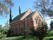
193 Hampton Rd Northampton
was 65 Hampton Rd
Anglican Church
Northampton
Midwest
Constructed from 1908 to 1959
| Type | Status | Date | Documents |
|---|---|---|---|
| Heritage List | Adopted | 15 May 2020 | |
| State Register | Registered | 15 Aug 2003 | HCWebsite.Listing+ListingDocument, HCWebsite.Listing+ListingDocument |
| Type | Status | Date | Documents |
|---|---|---|---|
| (no listings) |
| Type | Status | Date | Grading/Management | |
|---|---|---|---|---|
| Category | ||||
| Municipal Inventory | Adopted | 19 Apr 1996 | Category 1A | |
| Name | Type | Year From | Year To |
|---|---|---|---|
| Marwood, H.M. | Architect | - | - |
| Library Id | Title | Medium | Year Of Publication |
|---|---|---|---|
| 8512 | Proposed restoration works: Holy Trinity Church, Northampton, Western Australia. Final report. | Conservation works report | 2007 |
| 4682 | Holy Trinity Church : Northampton, Western Australia : conservation plan. | Heritage Study {Cons'n Plan} | 2000 |
Individual Building or Group
| Epoch | General | Specific |
|---|---|---|
| Original Use | RELIGIOUS | Church, Cathedral or Chapel |
| Present Use | RELIGIOUS | Church, Cathedral or Chapel |
| Style |
|---|
| Federation Gothic |
| Type | General | Specific |
|---|---|---|
| Wall | STONE | Granite |
| Roof | METAL | Corrugated Iron |
| General | Specific |
|---|---|
| SOCIAL & CIVIC ACTIVITIES | Institutions |
| SOCIAL & CIVIC ACTIVITIES | Religion |
This information is provided voluntarily as a public service. The information provided is made available in good faith and is derived from sources believed to be reliable and accurate. However, the information is provided solely on the basis that readers will be responsible for making their own assessment of the matters discussed herein and are advised to verify all relevant representations, statements and information.
Constructed from 1908
The Holy Trinity Anglican Church, Northampton is a coarse rubble weathered granite building designed in the Federation Gothic Revival style, with a corrugated iron, steeply pitched, gabled roof and surrounding landscaped grounds, is of cultural heritage significance for the following reasons: The place is an important component of the historic town of Northampton, which is characterised by a large collection of very fine buildings using similar building materials and forms, and collectively composing a significant cultural landscape; The place remains largely unaltered in both fabric and structure, with the operation and rituals of the Church still being practised today; The construction of the place, and its later expansion and completion, reflects the optimism and rise to prosperity of the Northampton community, and the importance of religion within the local community; and The place has strong association with many of the pioneering families within the region who were influential not only in the development of Northampton but further afield as well, including the Drages, Burges and Hosken families. Features considered to be of little significant are the ceiling fans and wall mounted chancel lights in the interior of the Church, while the wall fans, electrical switchboard, and radiators in the interior and plumbing vent pipes on the exterior of the building are considered to be intrusive.
Stone neo-gothic style church with CGI roof. The tall stone walls feature slender windows spaced between roof trusses down the side walls and a group of three windows in the gable end wall behind the altar. The windows have pointed gothic heads and rendered stone reveals externally to provide contrast with the surrounding stone walls. Over the heads of the windows a rendered weather moulding, terminating at an acanthus leaf boss, throws water clear of the stained glass glazing. The roof has a simple gable end form with small gambrel vents set into it along the length of the nave. The roofs generally terminate against a render capped stone wall. There is a small, enclosed stone entry porch with timber doors on the western end of the nave and a small vestry of to the side on the north, just in front of the altar. Both the porch and the vestry are later additions. Internally, the finishes are quite simple with rendered walls and plain pressed metal ceilings that slope up on the underside of the roof trusses until they flatten out across a collar tie under the ridge. A cross brace, or tie, between the lower members of the roof trusses is exposed across the ceiling. The exterior has recently been repointed (as at 2104).
At first, Anglican services were held in the interdenominational Gwalla Church (Site No.131), however in due course the Church of England erected a church in Northampton. The foundation stone of the Holy Trinity Church was laid on 26 February 1908 with Bishop Riley officiating. Located on Hampton Road, the main thoroughfare of the town, on land donated by Mrs. Hannah Hosken, the church was designed by Mr. H.M. Marwood and built by Messrs. Jenner and Hafner. The Hosken family contributed to the cost of the church. William Burges of The Bowes presented the church with an organ, Albert Drage gave a carved jarrah altar and Mrs L. D. Mitchell a baptismal font. Although the first service was held on 20 September 1908 the church was not officially consecrated by the Bishop until 18 January 1909. At that time the west wall was a temporary structure of wood and corrugated iron. In February 1959, W. Plant commenced working on the completion of the church in stone. The porch, west wall and vestry were added, and these were consecrated by Bishop Frewer on 29 September 1959. Prior to 1910 Northampton was attached to the Geraldton Parish and in 1928 it was passed from the Perth Diocese to the Diocese of North West Australia.
Integrity: High Orig'l Fabric: Fully intact
Good
| Name | Type | Year From | Year To |
|---|---|---|---|
| H.M. Marwood | Architect | 1908 | - |
| Ref ID No | Ref Name | Ref Source | Ref Date |
|---|---|---|---|
| BL Acc 816 B/B 500 | Photograph; "Church of England with Masonic Hall in background". | Battye Library | 1929 |
| Eastman & Poletti Pty Ltd Architects and Gary Martin; "Holy Trinity Church, Northampton, W.A., Conservation Plan," | 2000 | ||
| Feilman & Associates; "A Survey of Places of Historic and Landscape Significance in Northampton, Dongara, Geraldton, WA". | 1977 | ||
| Palassis; "Northampton Character Study". | |||
| Suckling, A.J; "The history of the Northampton District". p.116-117 | Teachers' Higher Certificate, | Undated |
| Owner | Category |
|---|---|
| Diocesan Trustees | Church Property |
This information is provided voluntarily as a public service. The information provided is made available in good faith and is derived from sources believed to be reliable and accurate. However, the information is provided solely on the basis that readers will be responsible for making their own assessment of the matters discussed herein and are advised to verify all relevant representations, statements and information.
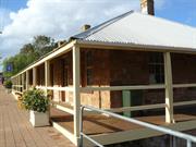
202 Hampton Rd Northampton
Cnr Hampton Rd & Stephen St
Northampton
Midwest
Constructed from 1884 to 1990
| Type | Status | Date | Documents |
|---|---|---|---|
| Heritage List | Adopted | 15 May 2020 | |
| State Register | Registered | 30 Oct 1998 | HCWebsite.Listing+ListingDocument, HCWebsite.Listing+ListingDocument |
| Type | Status | Date | Documents |
|---|---|---|---|
| (no listings) |
| Type | Status | Date | Grading/Management | |
|---|---|---|---|---|
| Category | ||||
| Municipal Inventory | Adopted | 19 Apr 1996 | Category 1A | |
17835 Hampton Road Precinct, Northampton
| Name | Type | Year From | Year To |
|---|---|---|---|
| R R Jewell | Architect | - | - |
| Library Id | Title | Medium | Year Of Publication |
|---|---|---|---|
| 3327 | Former Northampton Police Station and Courthouse : conservation plan. | Heritage Study {Cons'n Plan} | 1998 |
Individual Building or Group
| Epoch | General | Specific |
|---|---|---|
| Original Use | GOVERNMENTAL | Police Station or Quarters |
| Original Use | GOVERNMENTAL | Courthouse |
| Present Use | COMMERCIAL | Shop\Retail Store {single} |
| Style |
|---|
| Victorian Georgian |
| Type | General | Specific |
|---|---|---|
| Wall | STONE | Local Stone |
| Roof | METAL | Corrugated Iron |
| General | Specific |
|---|---|
| SOCIAL & CIVIC ACTIVITIES | Law & order |
This information is provided voluntarily as a public service. The information provided is made available in good faith and is derived from sources believed to be reliable and accurate. However, the information is provided solely on the basis that readers will be responsible for making their own assessment of the matters discussed herein and are advised to verify all relevant representations, statements and information.
Constructed from 1884
The former police station has local historic, social and aesthetic significance and makes an important contribution to the street and townscape character of Northampton.
The original stone walls of the former police station and lockup remain with their unpainted finish. A large hipped CGI roof extending down over the verandahs cover the building. The verandahs surrounding the premises have had some later timber framed enclosures to the rear which are generally unsympathetic. Internally there have been some modifications but these have not interfered too significantly with the original fabric and planing.
From 1869, two mounted policeman and an Aboriginal tracker were based at the Gwalla Mines. The station was closed at the end of 1872 and moved to a more central position in Northampton where a building was rented from Mr Shenton. Tenders were called for a police station in Northampton in 1884. The building was designed by James Manning and cost £1149. Renovations were made to the building in 1912 (Geraldton Guardian 07/12/1911). The stone police station was used until the new building was constructed further north along Hampton Road in 1963 (Site No. 49). The building also housed a courthouse, lock-up and quarters for two policemen. To the rear of the building was the cell block which has since been demolished.( Lyn Diepeveen)
Integrity: Medium Modifications: Verandah enclosures at rear. Orig'l Fabric: Mostly intact
Fair
| Name | Type | Year From | Year To |
|---|---|---|---|
| James Manning | Architect | 1884 | - |
| Ref ID No | Ref Name | Ref Source | Ref Date |
|---|---|---|---|
| Feilman & Associates; "A Survey of Places of Historic and Landscape Significance in Northampton, Dongara, Geraldton, WA", | 1977 | ||
| BL Acc 4326 B/13/8 | Photograph; "the old Police Station". | Battye Library | 1970 |
| Palassis; "Northampton Character Study". | |||
| "Old Police Station given recognition". | Geraldton Guardian | 17/07/1998. | |
| "Tenders for new building in Northampton'". | Victorian Express | 25/06/1884. | |
| Griffiths, P; "Conservation Guidelines- Police Station", | 1994 | ||
| Pashley, A. R; "Policing Our State - A History of Police Stations and Police Officers in Western Australia 1829-1945", pp. 390-393 | EDUCANT, Cloverdale, | 2000 | |
| "Tenders for building in Northampton' | Victorian Express | 14/05/1884 | |
| GHS0530 | Photograph; "police station". | Undated | |
| "The Hampton Road Heritage Walk." |
| Owner | Category |
|---|---|
| Shire of Northampton | Local Gov't |
This information is provided voluntarily as a public service. The information provided is made available in good faith and is derived from sources believed to be reliable and accurate. However, the information is provided solely on the basis that readers will be responsible for making their own assessment of the matters discussed herein and are advised to verify all relevant representations, statements and information.
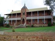
51 Hampton Rd Northampton
Nagle Centre
Northampton
Midwest
Constructed from 1919
| Type | Status | Date | Documents |
|---|---|---|---|
| Heritage List | Adopted | 15 May 2020 | |
| State Register | Registered | 26 Feb 1999 | HCWebsite.Listing+ListingDocument, HCWebsite.Listing+ListingDocument |
| Type | Status | Date | Documents |
|---|---|---|---|
| (no listings) |
| Type | Status | Date | Grading/Management | |
|---|---|---|---|---|
| Category | ||||
| Municipal Inventory | Adopted | 19 Apr 1996 | Category 1A | |
01904 Church of Our Lady in Ara Coeli
| Name | Type | Year From | Year To |
|---|---|---|---|
| Monsignor John Hawes | Architect | - | - |
| Library Id | Title | Medium | Year Of Publication |
|---|---|---|---|
| 3532 | Conservation Plan for the Nagle Centre (Former Presentation Sisters' Sacred Heart Convent) | Heritage Study {Cons'n Plan} | 1997 |
| 3440 | Report on 1998 Conservation Works at the Nagle Centre (Former Sacred Heart Convent), Lot 28 & Lot 29 Hampton Road Northampton - Heritage Grants Program 1997/8 (i 95/84) | Heritage Study {Other} | 1998 |
| 4310 | Nagle Centre : former Presentation Sisters' Sacred Heart Convent : former Irwin Centre: condition report. | Heritage Study {Other} | 1993 |
| 1685 | Nagle Centre former Irwin Centre : Former Presentation Sisters' Sacred Heart Convent, Hampton Road, Northampton : conservation guidelines. | Heritage Study {Other} | 1993 |
Individual Building or Group
| Epoch | General | Specific |
|---|---|---|
| Present Use | COMMERCIAL | Other |
| Present Use | RESIDENTIAL | Institutional Housing |
| Original Use | RELIGIOUS | Monastery or Convent |
| Style |
|---|
| Federation Gothic |
| Type | General | Specific |
|---|---|---|
| Wall | STONE | Other Stone |
| Roof | METAL | Corrugated Iron |
| Wall | BRICK | Common Brick |
| General | Specific |
|---|---|
| SOCIAL & CIVIC ACTIVITIES | Education & science |
| SOCIAL & CIVIC ACTIVITIES | Religion |
This information is provided voluntarily as a public service. The information provided is made available in good faith and is derived from sources believed to be reliable and accurate. However, the information is provided solely on the basis that readers will be responsible for making their own assessment of the matters discussed herein and are advised to verify all relevant representations, statements and information.
Constructed from 1919
The former convent has high local significance for historic, social and aesthetic reasons, particularly for its contribution to Northampton's townscape character. It has high significance on a State level for its associations with Mons. Hawes. Until the late 1950s, the convent bells marked time for many years, with the school bell times in between angelus rung at 6 am, 12 noon, 6 pm, and 12 midnight.
Two storeyed stone building with surrounding timber verandahs on both levels covered with a large CGI hipped roof with vented gambrel ends. A large internal staircase provides access to the top floor, several rooms and the upper verandah. Generally access to most of the rooms on both levels is external via the verandahs. The plan form is simple, being only one room wide to give good cross ventilation. The building fabric is in reasonably good condition although there has not been as much care with additions, the installation of services, repairs and maintenance over recent years to preserve the integrity of the original fabric. For example downpipes adjacent to the front tower are not are not well integrated and paving against the walls is aggravating damp problems. Although simple compared to Mons. Hawes better known work, the building is another excellent example of his work and forms a significant precinct with his adjoining church (see Site No.81). 2004/05 Review: Since the last review the roof to the central tower has been reinstated.
In 1899 the Presentation Sisters succeeded the Sisters of St. Joseph in the Convent School. The Sisters lived and worked in very poor conditions until 1919 when the existing convent building was built. The convent building housed the sisters who ran the Day and Boarding School, which were in separate buildings. However, over the years their numbers declined until in 1983 the Presentation Sisters vacated the convent. Although demolition was considered, in 1984 the Northampton Parish decided to renovate the building, turning it into a camp centre. Several outbuildings of the original precinct have been demolished, including the dormitories, music room, boarders' dinning room, laundry and maids' room, old school and toilet blocks. Initially called the Irwin Centre after parish priest Mons. J. Irwin, the name was changed in 1989 to honour the sisters who no longer lived in the town. The name of Nagle Camp Centre was chosen in memory of the founder of the Presentation of the Blessed Virgin Mary Sisters, Nano Nagle (1718-1784). The Northampton Tourist Bureau opened in the building on 4 September 1993. The Tourist Bureau has since relocated to the Old Police Station (Site No. 91), and old convent continues to be used for backpackers accommodation.
Integrity: Low Modifications: Brick Function Room and Toilet Block added at reat c1984 Orig'l Fabric: Mostly intact, turret to tower demolished
| Name | Type | Year From | Year To |
|---|---|---|---|
| Monsignor Hawes | Architect | 1919 | - |
| Ref ID No | Ref Name | Ref Source | Ref Date |
|---|---|---|---|
| Marchant James, R., "Cork to Capricorn" The congregation of The Presentation Sisters of WA 1891-1991". | The congregation of The Presentation Sisters of W. A., | 1996 | |
| Taylor, J;" Conservation Plan for the Nagle Centre" | HCWA | 1997 | |
| Taylor, J; "Condition report on the Nagle Centre". | HCWA | 1993 | |
| "Monsignor Hawes Heritage Trail" | Brochure | ||
| Feilman & Associates; "A Survey of Places of Historic and Landscape Significance in Northampton, Dongara, Geraldton, WA". | Geraldton Building Co Pty Ltd | 1977 | |
| 'Restoration for Convent Tower" | Geraldton Guardian | 05/08/1998. | |
| "The Hampton Road Heritage Walk." |
| Owner | Category |
|---|---|
| Roman Catholic Church Diocese of Geraldton | Church Property |
This information is provided voluntarily as a public service. The information provided is made available in good faith and is derived from sources believed to be reliable and accurate. However, the information is provided solely on the basis that readers will be responsible for making their own assessment of the matters discussed herein and are advised to verify all relevant representations, statements and information.
The Nagle Centre (former Presentation Sisters' Sacred Heart Convent 1919) the Convent has cultural heritage significance for the following reasons: • the Convent has a close association with prominent ecclesiastical architect Monsignor John Hawes. The place is an excellent example of Hawes' architectural style and is one of Hawes' earliest works in Western Australia; • the Convent is highly valued as a significant tourist attraction associated with Hawes' life and the adjacent church, and it contributes to the Northampton community 's sense of place; • the Convent has a high social value to the Northampton community; • the Convent has a strong spiritual significance for the Catholic community in the town of Northampton and in the Mid-West; and, • the Convent is an unusual and sophisticated building of interesting design which is a landmark in Northampton . Aesthetic Value The Convent has a high degree of artistic and technical sophistication, both internally and externally, and exhibits a well resolved combination of architectural, symbolic and artistic motifs. Itis highly valued by the Northampton community. The Convent is an excellent early example of John Hawes' Western Australian work and his eclectic architectural style. The Convent has a landmark quality in Northampton due to its large size and prominent elevated location looking over Hampton Road. In association with the Presbytery (1914), the Church (1936), and the School (1964); the Convent forms a 'precinct' of Catholic buildings in Northam pton. Historic Value The Convent has a close association with the expansion of the activities of the Catholic Diocese of Geraldton in the early party of the twentieth century. The Convent has a close association with Monsignor John Hawes, both as architect and administrator of the construction. Hawes' life and works are prominent within the history of the Mid-West Region of Western Australia . Social Value The Convent is highly valued by the community of Northampton and surrounding districts as a place in which the highly regarded Presentation Sisters lived - and from which they provided an exceptionally valued education; and as an outstanding architectural design. The Convent has great potentia l as a tourist accommodation destination which recognises the work of the Presentation Sisters and continues its large contribution to the Northampton community 's sense of place. Rarity The Convent is a rare example of the combination of Hawes' eclectic design principles with ills very personal understanding of the spiritual motifs required in, and the specialised planning required for, a Convent building. Representativeness The design of the Convent is representative of Monsignor J.C. Hawes' distinctive style of design. The Convent has an important role as a representative piece of multi-unit domestic archltecture by Hawes. Condition The Convent is in sound condition. Work has been done to alleviate problems of masonry deterioration and roof sheeting failure. Maintenance has been undertaken on a reasonably regular basis, and with restoration/reconstruction works (on the external tirnberwork particularly) the place could be brought back to very good condition. Integrity The Convent has a high degree of integrity. Although the Convent can no longer be used for the original purpose for which it was designed with the departure of the Sisters, the use of the Convent for residential purposes and the furnishing and presentation of the rooms to be representative of the era in which the place was built is compatible with the original intention of the place as accommodation . Authenticity The Convent is intact, and retains a high degree of authenticity. The 1990 addition completed as the function room although not harmonious with the original design, are tolerable. The changes to the interior that have occurred demonstrate evolution of use. The cement rendering of the walls externally can be reversed. The authenticity of the place is only marginally diminished.
For a discussion of the physical evidence refer to John Taylor Architect: "The 'Nagle Centre' Conservation Plan"(prepared for The St. Mary's Parish Council, February 1997)
Assessment 1997 Construction 1919 Alterations/additions 1985, 1990 Architect/designer John Cyril Hawes
This information is provided voluntarily as a public service. The information provided is made available in good faith and is derived from sources believed to be reliable and accurate. However, the information is provided solely on the basis that readers will be responsible for making their own assessment of the matters discussed herein and are advised to verify all relevant representations, statements and information.
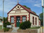
53 Hampton Rd Northampton
part of North West Coastal Highway
Public Library
Northampton
Midwest
Constructed from 1898 to 1964
| Type | Status | Date | Documents |
|---|---|---|---|
| Heritage List | Adopted | 15 May 2020 | |
| State Register | Registered | 09 Sep 2003 | HCWebsite.Listing+ListingDocument, HCWebsite.Listing+ListingDocument |
| Type | Status | Date | Documents |
|---|---|---|---|
| (no listings) |
| Type | Status | Date | Grading/Management | |
|---|---|---|---|---|
| Category | ||||
| Municipal Inventory | Adopted | 19 Apr 1996 | Category 2 | |
17835 Hampton Road Precinct, Northampton
| Library Id | Title | Medium | Year Of Publication |
|---|---|---|---|
| 5560 | Northampton Roads Board Building : conservation plan. | Heritage Study {Cons'n Plan} | 2002 |
| 8332 | Northampton roads board completion report. | Report | 2006 |
| 5601 | Images CD No. 1 | C D Rom | 2002 |
Individual Building or Group
| Epoch | General | Specific |
|---|---|---|
| Other Use | COMMERCIAL | Shop\Retail Store {single} |
| Present Use | EDUCATIONAL | Library |
| Original Use | Transport\Communications | Road: Office or Administration Bldg |
| Style |
|---|
| Federation Free Classical |
| Type | General | Specific |
|---|---|---|
| Wall | RENDER | Smooth |
| Wall | STONE | Local Stone |
| Wall | BRICK | Common Brick |
| Roof | METAL | Corrugated Iron |
| General | Specific |
|---|---|
| SOCIAL & CIVIC ACTIVITIES | Government & politics |
This information is provided voluntarily as a public service. The information provided is made available in good faith and is derived from sources believed to be reliable and accurate. However, the information is provided solely on the basis that readers will be responsible for making their own assessment of the matters discussed herein and are advised to verify all relevant representations, statements and information.
Constructed from 1898
The old Roads Board office has local historic, social and aesthetic (streetscape) significance.
The old Roads Board Office is a simple, single storey, rectangular stone walled building with brick quoining at corners and around windows. The roof is corrugated iron with stone gable ends. The existing small paned timber windows and front door appear to be original. Unfortunately the building's natural stone walls ( see early photographs - Northampton Historical Society ) have unsympathetically been painted white with brick quoining painted brown. This treatment is not at all successful at suggesting limewashed walls ( as with some of the miner' s cottages around the town ) and its appearance should relate more to the stone building of the former police station on the opposite side of the street.
Integrity: Low Modifications: Timber framed leanto at rear Orig'l Fabric: Mostly intact
Fair
| Ref ID No | Ref Name | Ref Source | Ref Date |
|---|---|---|---|
| Considine & Griffiths, "Conservation Plan for the Northampton Roads Board Office (former)" | 1999 | ||
| "The Hampton Road Heritage Walk." | |||
| Suckling, A.J; "The history of the Northampton District". p.125 | Teachers' Higher Certificate, | Undated | |
| Palassis; "Northampton Character Study". | |||
| Feilman & Associates; "A Survey of Places of Historic and Landscape Significance in Northampton, Dongara, Geraldton, WA". | Geraldton Building Co Pty Ltd | 1977 |
| Owner | Category |
|---|---|
| Shire of Northampton | Local Gov't |
This information is provided voluntarily as a public service. The information provided is made available in good faith and is derived from sources believed to be reliable and accurate. However, the information is provided solely on the basis that readers will be responsible for making their own assessment of the matters discussed herein and are advised to verify all relevant representations, statements and information.
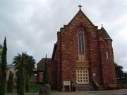
49-51 Hampton St Northampton
St Mary's
Northampton
Midwest
Constructed from 1936
| Type | Status | Date | Documents |
|---|---|---|---|
| Heritage List | Adopted | 15 May 2020 | |
| State Register | Registered | 28 Feb 1995 | HCWebsite.Listing+ListingDocument, HCWebsite.Listing+ListingDocument |
| Type | Status | Date | Documents |
|---|---|---|---|
| (no listings) |
| Type | Status | Date | Grading/Management | |
|---|---|---|---|---|
| Category | ||||
| Municipal Inventory | Adopted | 19 Apr 1996 | Category 1A | |
| Classified by the National Trust | Recorded | 27 May 1974 | ||
| Register of the National Estate | Indicative Place | |||
| Art Deco Significant Bldg Survey | Completed | 30 Jun 1994 | ||
17835 Hampton Road Precinct, Northampton
| Name | Type | Year From | Year To |
|---|---|---|---|
| Monsignor John Hawes | Architect | - | - |
| Library Id | Title | Medium | Year Of Publication |
|---|---|---|---|
| 7242 | "Saint Mary's in Ara Coeli", Roman Catholic Church, Lot 28 Hampton Street, Northampton : condition report. | Heritage Study {Other} | 1993 |
| 1674 | Conservation Plan : Saint Mary's in Ara Coeli Roman Catholic Church. | Heritage Study {Cons'n Plan} | 1994 |
| 202 | "St Mary's in Ara Coeli" Roman Catholic Church lot 28 Hampton Street Northampton for the Heritage Council of Western Australia | Heritage Study {Other} | 1993 |
Individual Building or Group
| Epoch | General | Specific |
|---|---|---|
| Original Use | RELIGIOUS | Church, Cathedral or Chapel |
| Present Use | RELIGIOUS | Church, Cathedral or Chapel |
| Style |
|---|
| Inter-War Romanesque |
| Inter-War Gothic |
| Type | General | Specific |
|---|---|---|
| Roof | TILE | Terracotta Tile |
| Wall | STONE | Other Stone |
| General | Specific |
|---|---|
| SOCIAL & CIVIC ACTIVITIES | Religion |
This information is provided voluntarily as a public service. The information provided is made available in good faith and is derived from sources believed to be reliable and accurate. However, the information is provided solely on the basis that readers will be responsible for making their own assessment of the matters discussed herein and are advised to verify all relevant representations, statements and information.
The church is valued bv the Comm unity for its association with the growth of religious activities and facilities in Northampton. lt ,:contributes to the Northampton community's sense of history .and sense of place, as demonstrated by its inclusion on the Monsignor Hawes Heritage Trail brochure. 2.2 Architectural/ Technical Accomplishment The church is a fine example of Mons. J.C. Hawes' idiosyncratic architectural style, utilising an eclectic mix of Gothic and Romanesque elements as applied to church design details and construction. 2.3 Environmental Importance; Townscape or Landscape Value; High Degree of Unity or Setting The church is a landmark in the town or Northampton and occupies a prominent hillside position. 2.4 Historical Significance of Development of Cultural Phases; Association with Important Figures The church is a demonstration of the faith and growth of the catholic community in Northampton, and was built at a time when the effects of the Depression were still being felt in small country tow ns. The building has strong associations with Mons. Hawes who, as an architect/ priest, made a significant contribution to the design and construction ot a number ot churches in the mid-\vest region of Western Australia between 1919-1939.
Physical Evidence St Mary 's in Ara Coeli Church is an eclectic mix of Gothic and Romanesque elements, constructed in 1936 to replace the original small Roman Catholic church on the site, built in 1868. It was built for Dean Irwin, priest of the Diocese of Northampton . In general, according to Apperly, Christian churches of the 1920s and 1930s usually adopted some form of well-worn medieval revivalism. More often than not, the Gothic language of pointed arch and steeply pitched roof continued to be employed to provide an instantly recognisable sign of a building's use for religious purposes. But when an architect wished to avoid this stereotype and perhaps move cautiously towards the uncluttered simplicity of mass and detail favoured by the modernists, an essay in the Romanesque might be undertaken.14 The Cathedral Chronicle of October 1936, provided the following description of the new church building :"As regards the exterior of the building, it gains character from the rugged nature of the hammer-dressed masonry,the deeply raked-out joints emphasising the charming and various colours of each stone. The main front of the church sheers up a precipitous cliff of rock: the effect of height increased by the long vertical lines of the massive buttresses springing upwards from the ground, and the soaring effect of the single deeply recessed arch. In the middle of this is set two-light long mullioned windows with traceried head. The green tiles that cover the roofs give a very similar appearance to the green Westmorland slates of the north of England. Over the intersection of chancel and transepts rises a tall slender fleche sunnounted by a silver ball and cross of wrought iron." St Mary's in Ara Coeli Church is sited on the slope of a hill facing Hampton Street, slightly north east of the old church (now demolished), and adjacent to the 'Nagle Centre' - a former Presentation Sisters' 'Sacred Heart' Convent. 15 The Church's ground plan is cruciform, consisting of a clerestoried nave with side aisles, and the high altar set at the junction of the north and south transepts, at the western end of the church. Being built on the slope of a hill, St Mary's in Ara Coeli Church has a flight of steps leading to the east door. Inside the porch, these steps divide to left and right, the wall between the two occupied by a set of doors through which the coffins, at funeral services, can be passed in or out of the church. Mons. J.C. Hawes' St Mary 's in Ara Coe/i Church design demonstrates an eclectic use of features from both the Romanesque and Gothic styles. The prominent pointed arch with plate tracery detailing at the entrance and the asymmetrical massing of the building, especially in relation to the tower, are distinct Gothic features. However, the rear and side windows employ rounded arches, a more Romanesque element. A feature of the exterior is the tall, circular turret in the north-west comer with its conical roof which encases a stone spiral stairway to the choir gallery. The interior of the building is simply decorated, featuring pointed arches to the sanctuary and transepts, the exposed timber roof trusses being particularly noteworthy. John Taylor, architect, mentions a number of features within the church that are also of particular note: the side aisles with their round arches; the louvred shutters; the clerestory of long windows, the natural lighting of the high altar from two very long narrow windows; and again, the impressive open hammer-beam roof in dark jarrah. 16 A recent condition report notes a number of maintenance items that will require addressing in the near future if the church is to remain in a sound condition, such as: some signs of damp penetration; drainage problems ; termite treatment; wall cracking; and, dislodgment of some roof tiles. Over the years, a number of minor alterations have been made to the internal layout of the church to accommodate the slight changes in needs that have occurred. For example: the Pulpit has been demolished; the table portion of the altar moved forward; the "nun 's chapel" in the south transept has been converted to reconciliation rooms/confessionals; and, some of the altar balustrades have been removed. Generally, the internal changes that have been made are to conform with changes in the practices of the Roman Catholic Church. For example: the priest celebrating the mass facing his congregation , rather than towards the altar at the rear-thus the table portion of the altar was moved forward.
Assessment 1997 Construction 1936 Architect/designer: Mons J.C.,Hawes The Northampton district was first settled during the 1850's with the establishment of the Geraldine Lead Mine in 1849. The region proved to be rich in copper and lead and more mines were soon established over the district, with two mines in particular, the Wanerenooka and the Gwalla, leading to the foundation of Northampton itself (1864). Together with mining activity, the area was recognised for its grazing potential and pastoralists moved up from the south. The fortunes of the mining industry waxed and waned over the years leaving agriculture as the mainstay of not only the district but of Northampton itself. However, a mining boom during 1910-27, saw the re-opening of several of the older mines together with the establishment of new ones. This re-newed activity in the mineral fields saw a rise in Northampton' s population and the northward extension of the railway line from Northampton to the small township of Ajana. By 1956 the mineral boom was over and many of the miners either moved away or settled down to agricultural pursuits. Documentary Evidence St Mary 's in Ara Coeli Church is an imposing building featuring an eclectic mix of Gothic and Romanesque elements, built, in 1936, to replace the existing church on the site that had served the needs of the parish for nearly 70 years. 1 The original church built, in 1868, under the guiding hand of Father Lecaille, was eventually demolished in 1963 to make way for a new brick Catholic school.2 The new church was sited slightly in front of the old building and occupies a prominent position on a hillside. The planning and construction of the church took place over several years, the architect for the project being Monsignor John C Hawes and the contractor, Mr. T.P. Crothers of Northampton .3 The signatures on the set of contract drawings are dated 1935.4 The foundation stone was laid on 24 May 1936, and reads, "This foundation Stone of St Mary 's in Ara Coeli was laid by the most Rev.J.P. O'Coll ins D.D. Bishop of Geraldton on the Feast of Our Lady of Christians 24th May 1936. Very Rev. Dean J. Irwin.Pastor.Very Rev.Dean J.C. Hawes Architect."5 The design concept for the church originated with Dean Irwin, priest of the Northampton Diocese, who after rejecting Hawes ' original design quietly but insistently argued that if a new church was to be built it was to be in the Gothic style. The Cathedral Chronicle reports, "At first he (J.C. Hawes) thought that Dean Irwin was very obstinate in rejecting his first scheme, but now he had to confess that he was quite right, and they could judge the finished results of their combined efforts.'>6 Mons. Hawes (1876-1956) was attached to the Geraldton Diocese between the years 1915-1839. Within that period he was architect, and in many cases the builder, of a number of Roman Catholic churches in the area. As a young man, Hawes trained as an architect, acquiring the skills and knowledge that would assist him later in life. Although he met with a measure of success in his profession, Hawes continued to feel drawn to a more religious life. In 1904, be took the step to join the Anglican Church. Following a period in the Bahamas he came to the conclusion that to be a proper priest be needed to belong to the Catholic Church.7 fu March 1911, he was received into the Catholic Church. As Father John Hawes, he arrived in Western Australia, in 1915, after meeting the Bishop of Geraldton while studying in Rome. Hawes continued his activities as an architect, h is skills particularly in demand in the Western Australian countryside where the vast open spaces and a small but growing population provided numerous opportunities to design new church buildings. His philosophy towards the design of church buildings is reflected in the following passage, "A proper church is no mere assembly-hall, theatre or auditorium for preaching and community singing: but it is first of all a place of sacrifice... It should breathe forth an atmosphere of prayer, of religious awe and supernatural mystery."' In addition, Hawes advocated that a church, regardless of size, should be of monumental character and that the design should be reminiscent of the past and also inclusive of the present - characteristics that are evident in St Mary's in Ara Coeli Church.9 His work ranged from the Geraldton Cathedral to a small church in Yalgoo. St Mary's in Ara Coeli Church and the Our Lady of Fatima Church, immediately south of the town of Nanson, were both built as churches to service a convent complex. In 1936, Hawes compared three of the buildings he had designed in the area, the Geraldton Cathedral (1916- 1936), the Mullewa Church (1920-1923), and the Northampton Church (1936), emphasising the design philosophy behind each. "In the Cathedral the underlying motif of the design was to express the idea of the solidity and strength of their church, hence the massive round pillars, almost cumbrous, and heavy roof timbers. At Mullewa, the motif was the antiquity of their church. compared with the Northampton Church it was not so impressive, nor as well proportioned ,but visitors found it interesting because its details were gathered from the far comers of the globe, and it reflected some of the romance and the quietness of some of the old, old churches of the past, that were full of such marvels as they would never see again. Spirituality was the motif of their Northampton church. In Gothic architecture all the lines soared upwards. Against the outer walls the strong buttresses sprang out of the ground and tapered aloft to the parapets. The sharp ridge of the steep roof cleft the sky like the bows of an ocean liner:and springing yet higher from the roof the spire pointed a finger heavenwards." w The planning and construction of the substantial church, over a number of years, was a community effort both the donation of labour and funds, made more difficult as the state was still recovering from the Depression years. At the opening ceremony the Hon. J. M. Drew, MLC mentioned that when he had been approached in 193 1, to make a donation, he was doubtful about the success of the project given the economic situation of the time. 11 However, the church was completed, and during the consecration proceedings the Bishop outlined the number of similar projects being carried out. "The Bishop said he arrived at the heightening of the depression and was still in it, but was pleased to state that U1e Diocese during that time has some six new churches (stone and cement brick), two presby teries, two convents, and a hospital, a college and three schools opened."12 A final remark at the opening ceremony illustrates the importance of the church at the time, "In conclusion His Lordship expressed his pleasure at being present on that grand occasion, and again congratulated Dean Irwin and all concerned with the new church, which, while enhancing the district of Northampton, would prove a source of pleasure to all travellers through the town."13 Over the years, changes to the liturgy within the Roman Catholic Church have resulted in modification of the internal arrangement of St Mary 's in Ara Coeli Church. The building has continued to be used as a church. The place will be entered into the forthcoming Northampton Town Planning scheme as a place of heritage value. The place is listed as being of heritage significance in the Monsignor Hawes Heritage Trail Brochure, an initiative of the Western Australian Heritage Committee and funded as part of the Commonwealth/State Bicentennial Commemorative Program. The church was entered on the National Trust of Australia' s (WA) Recorded List in May I 974.
This information is provided voluntarily as a public service. The information provided is made available in good faith and is derived from sources believed to be reliable and accurate. However, the information is provided solely on the basis that readers will be responsible for making their own assessment of the matters discussed herein and are advised to verify all relevant representations, statements and information.
Constructed from 1936
This church has very high significance locally for aesthetic and social reasons, and for its associations with builder Thomas P. Crothers (later of the Geraldton Building Company). It also has high State significance as another unusual example of Mons. Hawes' architecture.
This church is one of the most romantic of Mons. Hawes' churches with Gothic character, heavily influenced by' Arts and Crafts' motives, compared with his other churches in the surrounding region which generally exhibit classical language. The 'Arts and Crafts' influence comes through strongly with the circular tower with turret roof and the Dutch gable ends to roof hips. The green tiled roof may not be original but no evidence has been seen to the contrary. Externally the walls are random coursed sandstone, which features red stripes in the stone similar to that found in coastal areas like Kalbarri, but in this case was quarried at Willi Gulli. The walls are buttressed, articulated and stepped, finished with rendered capping. Windows are narrow, pointed, Gothic shape with rendered weather mouldings down the tops of the arches ending with an acanthus leaf boss (similar renderings are to be seen on the Naraling Church Hall - see Chapman Valley Municipal Inventory). Internally the roof is supported on splendid exposed timber trusses with a timber boarded ceiling above. Unfortunately over the sanctuary the ceiling has been replaced for whatever reason with a quite unsympathetic timber veneered plywood sheet ceiling. The arch separating the Sanctuary from the nave is painted with pink and white banding reminiscent of the monochromatic work inside the Mons. Hawes designed, St Xavier's Geraldton Cathedral. Over the entry is a carefully placed choir loft with access stairs rising in the base of the circular tower. There are arched aisles down both sides of the nave with high and low level narrow windows with louvred shutters for good summer ventilation. For comparative purposes, the following are comments recorded by the Feilman report -( High volumed stone church with tiled roof, significant style, condition - good, integrity - intact, recommendation - retain without alteration and maintain original character.)
In 1865 Belgian priest Father A.J. Lecaille was sent from Perth to care for the Catholic people in the Victoria District. He travelled on horseback between Greenough, Champion Bay, Northampton and Mullewa. Father Lecaille had a significant impact on the Northampton area and was a dearly loved member of the communities he visited. At first, services were held in the interdenominational Gwalla Church (Site No. 131). However, in 1868 the first Catholic Church was built in Northampton under the guiding hand of Father Lecaille, who opened and blessed the Church on 1 November 1868. This Church was demolished in 1963 when the new brick Catholic School was built. In 1936 the second Roman Catholic Church was built in Northampton, slightly in front of the original church and next to the convent (Site No.82). Designed by priest- architect Monsignor John Hawes, who was responsible for numerous churches in the area, the foundation stone was laid on 24 May 1936. Despite protests by Hawes, Dean Irwin had his wishes for a Gothic style building fulfilled. Using stone quarried from Willi Gulli (Site No.31), and donated by Mrs. M. Williams, the building contractor, Mr Thomas P. Crothers, was aided by many catholic residents from Northampton. St Mary in Ara Coeli was officially opened in October 1936. NOTE:Plans of the original design are held at the Catholic Presbytery in Geraldton. Chronology Entries 1867 Father Lecaille commenced building a school/church at Northampton. Source Pages Ancient Landmarks, Bain, M. A., UWA Press, Perth, 1975 ISBN:0 85564 090 1 274 Cork to Capricorn, Marchant James, R., The congregation of The Presentation Sisters of W. A. 171 1868 The Roman Catholic school was completed by Father Lecaille. Source Pages Ancient Landmarks, Bain, M. A., UWA Press, Perth, 1975 ISBN:0 85564 090 1 274 1936 The Roman Catholic Church of Our Lady in Ara Coeli was built. (Designed by Monsigneur Hawes) 1963 The old catholic church built by Father Lecaille was demolished to make way for a new Catholic school.
Integrity: High Orig'l Fabric: complete
Good
| Name | Type | Year From | Year To |
|---|---|---|---|
| Monsignor Hawes | Architect | 1936 | - |
| Ref ID No | Ref Name | Ref Source | Ref Date |
|---|---|---|---|
| Feilman & Associates; "A Survey of Places of Historic and Landscape Significance in Northampton, Dongara, Geraldton, WA". | 1977 | ||
| "New Church opened" | Geraldton Guardian | 24/09/1936. | |
| Taylor, J; "Condition report on St Mary's in Ara Coeli Roman Catholic Church: Condition Report", | HCWA | 1993 | |
| Taylor, J; "Conservation Plan on the St Mary's Church". | HCWA | 1994 | |
| Palassis; "Northampton Character Study". | |||
| Smith, K. R; "The Birth of a Legend - The history of the Geraldton Building Company and the men and women who made it possible". | Geraldton Building Co Pty Ltd, | 1994 | |
| "Monsignor Hawes Heritage Trail" | |||
| "The Hampton Road Heritage Walk." |
| Owner | Category |
|---|---|
| Roman Catholic Church Diocese of Geraldton | Church Property |
This information is provided voluntarily as a public service. The information provided is made available in good faith and is derived from sources believed to be reliable and accurate. However, the information is provided solely on the basis that readers will be responsible for making their own assessment of the matters discussed herein and are advised to verify all relevant representations, statements and information.
Henderson Tce Northampton
off Port Gregory Rd REGISTERED AS PART OF 1915
Northampton
Midwest
Constructed from 1853 to 1857
| Type | Status | Date | Documents |
|---|---|---|---|
| (no listings) |
| Type | Status | Date | Documents |
|---|---|---|---|
| (no listings) |
| Type | Status | Date | Grading/Management | |
|---|---|---|---|---|
| Category | ||||
| (no listings) | ||||
01915 Lynton Convict Hiring Depot (Ruins)
| Library Id | Title | Medium | Year Of Publication |
|---|---|---|---|
| 5169 | Sanford House : verandah reconstruction. | Heritage Study {Other} | 2000 |
| 5753 | Homesteads of the mid west region of Western Australia. | Book | 1997 |
| 5959 | Mrs Mulder's trough; Konnongoring Hall; Perenjori; Hawes, Mullewa; Lynton Heritage Site; Hassell Homestead. | Video | 1991 |
| 5130 | Lynton Heritage : conservation plan / by Considine and Griffiths Architects Pty Ltd. | Heritage Study {Cons'n Plan} | 1996 |
Individual Building or Group
| Epoch | General | Specific |
|---|---|---|
| FARMING\PASTORAL | Stable | |
| Present Use | FARMING\PASTORAL | Shed or Barn |
| Original Use | FARMING\PASTORAL | Shed or Barn |
This information is provided voluntarily as a public service. The information provided is made available in good faith and is derived from sources believed to be reliable and accurate. However, the information is provided solely on the basis that readers will be responsible for making their own assessment of the matters discussed herein and are advised to verify all relevant representations, statements and information.
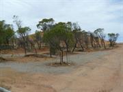
Horrocks Rd Northampton
approx 4 kms W of Northampton
Northampton
Midwest
Constructed from 1954
| Type | Status | Date | Documents |
|---|---|---|---|
| Heritage List | Adopted | 15 May 2020 | |
| State Register | Registered | 02 Jun 1998 | HCWebsite.Listing+ListingDocument, HCWebsite.Listing+ListingDocument |
| Type | Status | Date | Documents |
|---|---|---|---|
| (no listings) |
| Type | Status | Date | Grading/Management | |
|---|---|---|---|---|
| Category | ||||
| Municipal Inventory | Adopted | 19 Apr 1996 | Category 1A | |
| Library Id | Title | Medium | Year Of Publication |
|---|---|---|---|
| 5778 | Former State Battery, Northampton, Western Australia : conservation plan. | Heritage Study {Cons'n Plan} | 2002 |
| 5777 | Aboriginal heritage : a desktop survey of the Aboriginal heritage values of the Northampton State Battery, Northampton, Western Australia. | Report | 2002 |
| 9444 | Interpretation strategy for Northampton State Battery. | Heritage Study {Other} | 2005 |
Individual Building or Group
| Epoch | General | Specific |
|---|---|---|
| Present Use | VACANT\UNUSED | Vacant\Unused |
| Original Use | MINING | Mining Battery |
| Style |
|---|
| Other Style |
| Type | General | Specific |
|---|---|---|
| Roof | METAL | Corrugated Iron |
| Wall | ASBESTOS | Fibrous Cement, flat |
| Wall | METAL | Corrugated Iron |
| General | Specific |
|---|---|
| OCCUPATIONS | Mining {incl. mineral processing} |
| OUTSIDE INFLUENCES | Markets |
This information is provided voluntarily as a public service. The information provided is made available in good faith and is derived from sources believed to be reliable and accurate. However, the information is provided solely on the basis that readers will be responsible for making their own assessment of the matters discussed herein and are advised to verify all relevant representations, statements and information.
Constructed from 1953
1993 The site has very high local and high State significance for historic, social, and scientific reasons. 2004 Northampton State Battery, a lead battery complex consisting of crushing mill, offices, workshop, managers house, weighbridge and a large [gravity] dam has cultural heritage significance for the following reasons: •The place is the only surviving gravity separation plant for the treatment of heavy minerals in the Western Australian State Battery complex. •The place is directly related to the third phase of mining activity (1948-1981) in the Northampton [Murchison] mineral fields. •The place is valued by the local community and contributes to its sense of place. •The group of structures and machinery are dominant features in [over the natural] their modified environment.
1993 The State lead battery site still contains significant structures and machinery indicative of its former operation although some material has been removed. It is a good example of industrial architecture and the importance of the site is acknowledged with the Wheal Ellen mine site (Site 117) as a precinct in the Northampton Town Planning Policies which suggests tourism potential for the site. See also similar comments for Wheal Fortune (Site No.35) and Baddera (Site No.37) mines. 2004 For a full description see Eastman and Poletti etal. The structure of the building housing the Battery remains relatively intact although the external cladding fabric is in poor condition. Much of the Battery plant is however missing, having been sold off and removed upon closure of the site. The Battery is now in need of some urgent repair work, particularly in the weatherproofing of the building and the stabilisation of adjacent ground, to ensure that it does not suffer further deterioration, which may seriously undermine its condition. The fabric of the Managers Residence and office is in poor condition, but does not contribute to the cultural significance of the site and would not warrant substantial repair works. At the time of the 2004 Ml review a section of the rear gantry had been deliberately collapsed by the (presumably illegal) removal of vertical pipework (State Battery 1 to 2). The tailings dump area remains relatively unstable and unvegetated, and the issue of lead contamination of the Nokanena Brook continues to be of environmental concern for the community and the Department of Environmental Protection. At the time of the 2004 Ml review there was no evident progress in rehabilitation of the tailings area.
1993 Construction of the Lead Battery commenced in 1953 and was operational by 1954 continuing through into the midlate 60's; though less than 50 years old it was, nonetheless, an important part of the mining industry for the time. Its construction was in response to the jump in the world price of lead in the mid 1940's which caused a post war revival in the Western Australian mining industry. 2004 The structure of the building housing the Battery remains relatively intact although the external cladding fabric is in poor condition. Much of the Battery plant is however missing, having been sold off and removed upon closure of the site. The Battery is now in need of some urgent repair work, particularly in the weatherproofing of the building and the stabilisation of adjacent ground, to ensure that it does not suffer further deterioration, which may seriously undermine its condition. The fabric of the Managers Residence and office is in poor condition, but does not contribute to the cultural significance of the site and would not warrant substantial repair works. The tailings dump area remains relatively unstable and unvegetated, and the issue of lead contamination of the Nokanena Brook continues to be of environmental concern for the community and the Department of Environmental Protection. Planning by the Department of Mines, for the Former State Battery at Northampton, had commenced even before 1949 when the site was surveyed. Construction, coordinated by the Department, commenced in 1952 and the Battery was officially opened in 1954. The Battery was built on mineral lease land surrendered to the Department in 1952. This original reservation has been extended on a number of occasions to form the site currently vested in the Minister. The Battery was inactive from 1 April 1983. The Shire of Northampton expressed interest in taking the place over for tourism, and the Superintendent of State Batteries recommended this strategy to the Director General of Mines. However, the proposal was rejected for reasons of insurance and a desire to keep the Battery in working order. The plant was put on a care and maintenance from November 1984. In June 1989, the Western Australian Mint announced that the mill and fittings, house and ancillary buildings at the Battery had been sold at public tender to Plantagenet Securities Pty Ltd. In the succeeding years, most of the plant was sold off piecemeal by the company. The Battery, its site and the associated building infrastructure are now the property of the Western Australian State Government through the Western Australian Mint. The Battery and buildings are unused and derelict, and the site secured and signposted with warnings as to the dangerous nature of the lead tailings at the site.
Integrity: Low
Poor
| Ref ID No | Ref Name | Ref Source | Ref Date |
|---|---|---|---|
| Eastman and Poletti Pty and Gerard MacGill and Associates; "Former State Battery, Northampton, Western Australia, Conservation Plan". | Department of Housing and Works, WA. | 2002 |
| Owner | Category |
|---|---|
| West Australian Mint | State Gov't |
This information is provided voluntarily as a public service. The information provided is made available in good faith and is derived from sources believed to be reliable and accurate. However, the information is provided solely on the basis that readers will be responsible for making their own assessment of the matters discussed herein and are advised to verify all relevant representations, statements and information.
Ivans Rd Northampton
north of Brookside off Port Gregory Rd, Undandarra Gully. 8km W of Northampton on the Port Gregory Rd.
Rosser's
Northampton
Midwest
Constructed from 1877, Constructed from 1880
| Type | Status | Date | Documents |
|---|---|---|---|
| Heritage List | Adopted | 15 May 2020 | |
| State Register | Registered | 25 Jun 2004 | HCWebsite.Listing+ListingDocument, HCWebsite.Listing+ListingDocument |
| Type | Status | Date | Documents |
|---|---|---|---|
| (no listings) |
| Type | Status | Date | Grading/Management | |
|---|---|---|---|---|
| Category | ||||
| Municipal Inventory | Adopted | 19 Apr 1996 | Category 1A | |
| Library Id | Title | Medium | Year Of Publication |
|---|---|---|---|
| 5718 | Brookside and Hillview, Northampton : conservation plan. | Heritage Study {Cons'n Plan} | 2002 |
| 6093 | Images CD No. 13 : Brookside and Hillview. | C D Rom | 2002 |
Individual Building or Group
| Epoch | General | Specific |
|---|---|---|
| Original Use | FARMING\PASTORAL | Cottage |
| Present Use | VACANT\UNUSED | Vacant\Unused |
| Style |
|---|
| Victorian Georgian |
| Federation Bungalow |
| Type | General | Specific |
|---|---|---|
| Wall | STONE | Local Stone |
| Roof | METAL | Corrugated Iron |
| General | Specific |
|---|---|
| DEMOGRAPHIC SETTLEMENT & MOBILITY | Land allocation & subdivision |
| OCCUPATIONS | Grazing, pastoralism & dairying |
This information is provided voluntarily as a public service. The information provided is made available in good faith and is derived from sources believed to be reliable and accurate. However, the information is provided solely on the basis that readers will be responsible for making their own assessment of the matters discussed herein and are advised to verify all relevant representations, statements and information.
This information is provided voluntarily as a public service. The information provided is made available in good faith and is derived from sources believed to be reliable and accurate. However, the information is provided solely on the basis that readers will be responsible for making their own assessment of the matters discussed herein and are advised to verify all relevant representations, statements and information.

39 Mary St Northampton
Northampton
Midwest
Constructed from 1912
| Type | Status | Date | Documents |
|---|---|---|---|
| Heritage List | Adopted | 15 May 2020 |
| Type | Status | Date | Documents |
|---|---|---|---|
| (no listings) |
| Type | Status | Date | Grading/Management | |
|---|---|---|---|---|
| Category | ||||
| Municipal Inventory | Adopted | 18 Nov 2005 | Category 2 | |
01911 Northampton Railway Station Precinct
Individual Building or Group
| Epoch | General | Specific |
|---|---|---|
| Original Use | Transport\Communications | Rail: Housing or Quarters |
This information is provided voluntarily as a public service. The information provided is made available in good faith and is derived from sources believed to be reliable and accurate. However, the information is provided solely on the basis that readers will be responsible for making their own assessment of the matters discussed herein and are advised to verify all relevant representations, statements and information.
Constructed from 1912
The Station master's House has strong local significance historically and socially because of its association with and contribution to the railway group of buildings [See Sites 77, 79, 80, 134 & 135].
Timber framed weatherboard Station Master's house located behind the Northampton Railway Station/siding (Site No.77). Probably fairly typical for its time. The extent of verandahs may have increased with time, particularly the hipped verandah on the SW corner. There is a louvred vent through W/B gabled end to ventilate the roof space adjacent to a free standing brick chimney on the south elevation. Entry door is 4 panel timber and windows are 6 pane double hung to the front elevation. At the time of writing the initial M.I. Report, the verandahs were unsympathetically enclosed with vertical shadow line asbestos sheeting and glass louvres. These are being removed and the outside being repainted by the current owners who also advise that the interior of the original sections of the house feature pressed tin to all walls and ceilings. There is some original door furniture, and one of two original fireplaces still functions but has been remodelled.
The Geraldton- Northampton line was opened for traffic in 1879. Originally terminating at the Gwalla Station(Site No. 134), the line was extended to Ajana in 1912. At this time the railway was relocated to the more central Mary Street location. The station Master's house was built directly behind the new railway station and used as such until 1957 when the Geraldton- Northampton line was closed as part of W.A.G.R.'s review of unprofitable lines.
Integrity: High Modifications: Verandah enclosures
Good
This information is provided voluntarily as a public service. The information provided is made available in good faith and is derived from sources believed to be reliable and accurate. However, the information is provided solely on the basis that readers will be responsible for making their own assessment of the matters discussed herein and are advised to verify all relevant representations, statements and information.
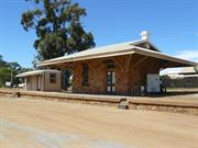
67 & 69 Mary St Northampton
Additional address: 103 Stephen St, Northampton. VFL - 25/3/2011. Includes: Rest Room, Station Masters House, Old Wheat Bin, Weighbridge & turntable - site of
Northampton
Midwest
Constructed from 1912 to 1953
| Type | Status | Date | Documents |
|---|---|---|---|
| Heritage List | Adopted | 15 May 2020 | |
| State Register | Registered | 15 Jan 2013 | HCWebsite.Listing+ListingDocument, HCWebsite.Listing+ListingDocument |
| Type | Status | Date | Documents |
|---|---|---|---|
| (no listings) |
| Type | Status | Date | Grading/Management | |
|---|---|---|---|---|
| Category | ||||
| Classified by the National Trust | Classified | 10 Feb 2003 | ||
| Statewide Railway Heritage Surve | Completed | 19 Apr 1996 | ||
16294 Northampton-Ajana Railway Precinct
The railway station is in fair condition overall. The Station House is in fair condition externally and good condition internally. The Weighbridges are in fair condition. The Ladies Waiting Room and Platform are in fair to poor condition. The Loading Platform and remains of the Turntable are in poor condition.
| Library Id | Title | Medium | Year Of Publication |
|---|---|---|---|
| 9402 | Northampton Railway Station | Heritage Study {Cons'n Plan} | 2009 |
Precinct or Streetscape
| Epoch | General | Specific |
|---|---|---|
| Present Use | GOVERNMENTAL | Fire Station |
| Other Use | GOVERNMENTAL | Office or Administration Bldg |
| Original Use | Transport\Communications | Rail: Other |
| Original Use | Transport\Communications | Rail: Railway Station |
| Style |
|---|
| Federation Free Classical |
| Type | General | Specific |
|---|---|---|
| Roof | METAL | Corrugated Iron |
| Wall | STONE | Local Stone |
| General | Specific |
|---|---|
| TRANSPORT & COMMUNICATIONS | Rail & light rail transport |
This information is provided voluntarily as a public service. The information provided is made available in good faith and is derived from sources believed to be reliable and accurate. However, the information is provided solely on the basis that readers will be responsible for making their own assessment of the matters discussed herein and are advised to verify all relevant representations, statements and information.
This information is provided voluntarily as a public service. The information provided is made available in good faith and is derived from sources believed to be reliable and accurate. However, the information is provided solely on the basis that readers will be responsible for making their own assessment of the matters discussed herein and are advised to verify all relevant representations, statements and information.
Port Gregory Rd Northampton
Port Gregory Rd (off)/Undandarra Gully
Northampton
Midwest
| Type | Status | Date | Documents |
|---|---|---|---|
| Heritage List | Adopted | 15 May 2020 |
| Type | Status | Date | Documents |
|---|---|---|---|
| (no listings) |
| Type | Status | Date | Grading/Management | |
|---|---|---|---|---|
| Category | ||||
| Municipal Inventory | Adopted | 19 Apr 1996 | Category 1A | |
08922 Brookside, Hillview & Surrounds
Individual Building or Group
| Epoch | General | Specific |
|---|---|---|
| Present Use | VACANT\UNUSED | Vacant\Unused |
| Original Use | FARMING\PASTORAL | Cottage |
| Type | General | Specific |
|---|---|---|
| Roof | METAL | Corrugated Iron |
| Wall | STONE | Local Stone |
| General | Specific |
|---|---|
| OCCUPATIONS | Grazing, pastoralism & dairying |
This information is provided voluntarily as a public service. The information provided is made available in good faith and is derived from sources believed to be reliable and accurate. However, the information is provided solely on the basis that readers will be responsible for making their own assessment of the matters discussed herein and are advised to verify all relevant representations, statements and information.
| Ref ID No | Ref Name | Ref Source | Ref Date |
|---|---|---|---|
| Feilman & Associates, "A Survey of Places of Historic and Landscape Significance in Northampton, Dongara, Geraldton, WA". | 1977 | ||
| Considine & Griffiths; "Brookside and hillview Northampton Conservation Plan".. | 2002 |
This information is provided voluntarily as a public service. The information provided is made available in good faith and is derived from sources believed to be reliable and accurate. However, the information is provided solely on the basis that readers will be responsible for making their own assessment of the matters discussed herein and are advised to verify all relevant representations, statements and information.
Port Gregory Rd Northampton
Off Undandarra Gully
Rosser's
Northampton
Midwest
| Type | Status | Date | Documents |
|---|---|---|---|
| (no listings) |
| Type | Status | Date | Documents |
|---|---|---|---|
| (no listings) |
| Type | Status | Date | Grading/Management | |
|---|---|---|---|---|
| Category | ||||
| Municipal Inventory | Adopted | 19 Apr 1996 | ||
08922 Brookside, Hillview & Surrounds
Individual Building or Group
| Epoch | General | Specific |
|---|---|---|
| Original Use | FARMING\PASTORAL | Homestead |
This information is provided voluntarily as a public service. The information provided is made available in good faith and is derived from sources believed to be reliable and accurate. However, the information is provided solely on the basis that readers will be responsible for making their own assessment of the matters discussed herein and are advised to verify all relevant representations, statements and information.
Constructed from 1860
Hillview has lost its roof, front and rear verandahs. Part of the north and west walls have collapsed.
Hillview was owned by the Rosser family until 1944
Poor
| Ref ID No | Ref Name | Ref Source | Ref Date |
|---|---|---|---|
| Feilman & Associates, "A Survey of Places of Historic and Landscape Significance in Northampton, Dongara, Geraldton, WA." | 1977 | ||
| Considine & Griffiths; "Brookside and Hillview, Northampton: Conservation Plan". | 2002 |
This information is provided voluntarily as a public service. The information provided is made available in good faith and is derived from sources believed to be reliable and accurate. However, the information is provided solely on the basis that readers will be responsible for making their own assessment of the matters discussed herein and are advised to verify all relevant representations, statements and information.
Port Gregory Road Northampton
Registered as part of P1915 Lynton Convict Hiring Depo (Ruin)
Northampton
Midwest
Constructed from 1853
| Type | Status | Date | Documents |
|---|---|---|---|
| (no listings) |
| Type | Status | Date | Documents |
|---|---|---|---|
| (no listings) |
| Type | Status | Date | Grading/Management | |
|---|---|---|---|---|
| Category | ||||
| Municipal Inventory | Adopted | 18 Nov 2005 | Category 1A | |
01915 Lynton Convict Hiring Depot (Ruins)
Individual Building or Group
| Epoch | General | Specific |
|---|---|---|
| Original Use | RESIDENTIAL | Other |
This information is provided voluntarily as a public service. The information provided is made available in good faith and is derived from sources believed to be reliable and accurate. However, the information is provided solely on the basis that readers will be responsible for making their own assessment of the matters discussed herein and are advised to verify all relevant representations, statements and information.
Constructed from 1853
The Lynton Homestead is of very high historic, social and aesthetic significance to the district and the State because of its associations with the convict hiring depot, the links with the Port Gregory area and the commanding setting and construction of its buildings.
Sanford's imposing two storey residence sits on the side of a hill closer to the coast than the hiring station (Site No.25). The lower floor, with kitchen and possible servant's rooms is cut into the side of the hill so that the rear of the upper floor is virtually at ground level. Originally the house had large verandah/balconies across the front which had collapsed and been removed. Recently grants have helped fund a restoration programme which has seen the limestone walls stabilised, the roof reinstated and the verandah/balconies replaced. The homestead has several significant stone out buildings These include a well proportioned barn, still in good condition through having enjoyed a continuing useful life, and a stone flour mill which has been re-roofed and restored in recent years. Down towards the convict hiring depot, under the shade of a tree, is a small cemetery with three graves including two children's graves. Unfortunately the headstones are deteriorating and have suffered damage by stock over the years
Known variously as Sanford's House, the Lynton Homestead and the Governor's Residence, Captain H.A. Sanford, the supervisor of the convict depot had an elegant, two-storeyed house built for himself in 1853. The date is carved into the keystone above the main doorway. Set against the side of a limestone hill, it was positioned in the sheltered lee of a breakaway, overlooking the valley and the distant sea at the mouth of the Hutt River. Lynton, the name given to Sanford's residence, was named after a little English village in Upper Tooting, Surrey. Like the buildings of the hiring depot, the house was built of faced limestone. Although parts of old ships masts were used for the balcony and verandah posts of the homestead, other timber had to be transported from Fremantle. (Trenaman, p. 13). The house was built with no inner staircase- steps outside led up to the higher level. Nearby Sanford had a circular stone -mill and a large barn erected. The convict arrow, cut into the stone high on the eastern wall of the barn, suggests that it was convict built. However other sources claim that the arrow was a later addition carved by T.P.Crothers during repairs to the barn in the 1920s. (Lyn Diepeveen). There were also yards and gardens and a well, but these have now gone. Captain Henry Ayshford Sanford first arrived on the 'Dido', on the 7th Dec. 1852, and was appointed Magistrate of the Territory (a Justice of the Peace) and Superintendent of Convicts. In 1853 he was appointed to take charge of the Port Gregory Hiring Station as well as Sub Collector of Customs and District Registrar for the port. Sanford was only at the Depot for a year, resigning his commission in December 1854 in order to pursue his other local interests, including whaling, farming and mining. Sanford leased 48 000 acres surrounding the Lynton Townsite area which was surveyed in 1853, and on 9th Oct. 1853, purchased Victoria Location No. 10, of 150 acres where the homestead was built. When he decided to return to England in 1858, Sanford leased the homestead to Mr Charles von Bibra, who opened a store, (and was later granted a publicans license) to serve the passing miners, bullock drivers, whalers and shepherds in the area. Sanford then leased the property to Mr Bateman who ran a boarding house in the homestead. In 1860 Sanford returned from England with his bride of some months whom he took to live at Lynton. Although they did not live there long it was not until 7 August 1869 that the property was transferred to Mr Robert Mace Habgood for the sum of 500 pounds, along with other blocks in Packington and Lynton (Blocks M,N, & O). Lynton was transferred to Robert Henry Habgood in 1883 and then to Sarah Habgood in 1889. The property was sold the following year to Rev. Daniel Glyn Watkins and Edward Horne-Wittenoom. The Brand family owned Lynton from c1907-1941 when it was sold to Ross Eric and Henry Ronald Drage. They sold it to Donald Edward and Henry Frederick Broad in 1949. In 1960 the property was purchased by George S. A. Bunter. Three years later, it was bought by the Simkin family. The house was occupied and maintained in reasonable condition, at least until the 1940's [S. Simkin]. Since then it has served as a farm store and until recently has been in a poor state of repair. However, community efforts have now resulted in the building being re-roofed and the stonework stabilised. The land on which the depot and Sanford' s house stand has been donated by the Simkin family, and is vested in the Shire of Northampton. Chronology Entries 1853 Captain Sanford was appointed magistrate of the Port Gregory district. 1854 Captain Sanford leased his property to Charles von Bibra. 1856 Permission was granted to Charles von Bibra to open a public boarding house with a license to reta:i spirits at Sanford House. This was the first liquor licence issued in the Victoria District.
Integrity: Medium Modifications: New CGI roof Orig'l Fabric: Reasonably intact
Poor
| Ref ID No | Ref Name | Ref Source | Ref Date |
|---|---|---|---|
| Bodycoat, R. Lynton; "A Study of the Convict Hiring Depot". | 1982 | ||
| GHS3077 | Photograph; " House" | 1968 | |
| Photograph | Geraldton Guardian | 02/06/1962; | |
| GHS6629 | Photograph; " Barn". | 1967 | |
| Considine & Griffiths Architects Pty Ltd; "Lynton Heritage Conservation Plan". | Considine & Griffiths Architects Pty Ltd, | 1996 | |
| Lilley, I. & Gibbs, M. , An Archaeological Study of the Lynton Hiring Depot,". | 1993 | ||
| GHS3078 | Photograph; "Rear View of the House". | 1968 | |
| GHS3053 | Photograph; " House". | 1968 | |
| GHS6631 | Photograph; " Flour Mill". | 1967 | |
| GHS6198 | Photograph; "Graves". | 1972 | |
| GSH5220 | Photograph; " House- late 1800's" | ||
| Feilman & Associates, "A Survey of Places of Historic and Landscape Significance in Northampton, Dongara, Geraldton, WA", | Feilman & Associates, | 1977 | |
| Trenaman, H.R. "Port Gregory and Lynton", Early Days". Vol 2 Part 16 | 1934 | ||
| GHS3067 | Photograph; " Barn". | 1967 | |
| "Lynton Achievement recognised" | Midwest times | 5/10/1994, | |
| GHS3071 | Photograph; "1853 Stone". | Undated | |
| GHS3076 | Photograph; "Side View of the House". | 1968 | |
| GHS6634 | Photograph; " House" | 1967 |
This information is provided voluntarily as a public service. The information provided is made available in good faith and is derived from sources believed to be reliable and accurate. However, the information is provided solely on the basis that readers will be responsible for making their own assessment of the matters discussed herein and are advised to verify all relevant representations, statements and information.
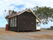
Rob Rd Northampton
off Chilmony Road
Alma School Building
Northampton
Midwest
Constructed from 1914 to 1915
| Type | Status | Date | Documents |
|---|---|---|---|
| Heritage List | Adopted | 15 May 2020 | |
| State Register | Registered | 11 Aug 1995 | HCWebsite.Listing+ListingDocument, HCWebsite.Listing+ListingDocument |
| Type | Status | Date | Documents |
|---|---|---|---|
| (no listings) |
| Type | Status | Date | Grading/Management | |
|---|---|---|---|---|
| Category | ||||
| Municipal Inventory | Adopted | 19 Apr 1996 | Category 1A | |
| Library Id | Title | Medium | Year Of Publication |
|---|---|---|---|
| 12244 | The former Alma School - Shire of Northampton 1916 | Other | 1994 |
| 2487 | Alma School corner Rob and Chilimony Roads, Northampton : condition report. | Report | 1993 |
Individual Building or Group
| Epoch | General | Specific |
|---|---|---|
| Present Use | SOCIAL\RECREATIONAL | Other Community Hall\Centre |
| Original Use | EDUCATIONAL | Combined School |
| Style |
|---|
| Vernacular |
| Type | General | Specific |
|---|---|---|
| Roof | METAL | Corrugated Iron |
| Wall | TIMBER | Weatherboard |
| General | Specific |
|---|---|
| SOCIAL & CIVIC ACTIVITIES | Education & science |
This information is provided voluntarily as a public service. The information provided is made available in good faith and is derived from sources believed to be reliable and accurate. However, the information is provided solely on the basis that readers will be responsible for making their own assessment of the matters discussed herein and are advised to verify all relevant representations, statements and information.
Constructed from 1916
The school and trees have high social and historic significance for the local community, as is evident by the Bicentennial commemorative plaque.
Typical timber framed one classroom pavilion-type building of the period, with verandah along one side. The weatherboard building, on timber stumps and with timber flooring, has a brick chimney across the south-west corner. The high gable ends have metal louvre wall vents. A tall double hung nine pane window, with high sill is adjacent to the four panel entry door and highlight opening off the verandah. There are three 6 pane double hung windows with pivoting 6 pane highlight over on opposite wall to entry. High ceilings and internal walls are clad in plasterboard with timber battens. The corner fireplace is still operational. Original blackboards with timber shelf brackets and surrounds exist in good condition. There is a timber dais across the full width of the room under the front blackboard. The CGI roof is painted red. Adjacent to the old school are tennis courts and an unsympathetic concrete block shelter shed. The adjacent large eucalypts are significant to the site and require protection. Outbuildings (shelter shed & toilets) have since been demolished.
The original Alma School was located south of the present building near the Iga Mine, on Unanderra Gully. The site is marked by two tall lemon scented gum trees which were planted when the school was built in 1905. Education Department records reveal that the school was opened on 6 August 1905 with an enrolment of 13 pupils. In rural communities schools were often relocated to follow the moving farming population. Tenders were called in December 1911 to relocate Alma School [Geraldton Guardian 07/12/1911). In April 1912 the Alma School was moved to a position near the junction of Rob Road and North West Coastal Highway. The new building consisted of a combined school and teacher's quarters. When the classroom became too small a partition was removed to make the room larger. The teacher at the time, Mr Passmore, had to live in a tent nearby. In 1916 the present school building was constructed and the old building was once again used as the teacher's quarters. In 1946 the present governing group, "Alma Community Centre", formed with the aim of providing support to the school and promoting community activities, such as a tennis club, for local residents. The school functioned until 1956 when it became one of the numerous casualties of the centralisation of education. Since then children in this locality have been transported by bus to Northampton. Other schools which suffered the same fate as Alma include Ajana (Site No. 188), Sandy Gully (Site No. 193), Isseka (Site No. 189), Yuba (Site 191), and Galena (Site No.159). These sites, including Alma, are marked by Bicentennial commemorative plaques. In 1957 local residents purchased the Alma school building from the Education Department for 120 pounds and two years later the land was vested in the Northampton Road Board (now Shire) as Hall and Recreation. Since then the Alma School building has been used as a community hall, where meetings and social occasions are often held, including the traditional children's Christmas Tree, quiz nights and small concerts. Local community efforts have maintained the building in an excellent condition. Chronology Entries 24/08/1956 The Alma School was officially closed by the Education Department. The building was thep. purchased by local residents for use as a community hall.
Integrity: High Orig'l Fabric: Fully intact
Good
| Ref ID No | Ref Name | Ref Source | Ref Date |
|---|---|---|---|
| Taylor, J., "Alma School - Condition Report" | Heritage Council of WA | Aug 1993 | |
| Gable W; "Rural and isolated Schools, the development of Western Australia School: Alma, Shire: Northampton". | 1988 | ||
| Suckling, A. J; "History of the Northampton District". | |||
| 'Memories Rekindled' | Geraldton Guardian | 28/10/2002. | |
| Patrick, B. "The One Teacher School". | Northampton News, | Feb 1993 | |
| Feilman & Associates, "A Survey of Places of Historic and Landscape Significance in Northampton, Dongara, Geraldton, WA". | 1977 | ||
| Suba, T; "The Thematic History of the Town of Northampton" | Shire of Northampton | 1993 |
| Owner | Category |
|---|---|
| Shire of Northampton | Local Gov't |
This information is provided voluntarily as a public service. The information provided is made available in good faith and is derived from sources believed to be reliable and accurate. However, the information is provided solely on the basis that readers will be responsible for making their own assessment of the matters discussed herein and are advised to verify all relevant representations, statements and information.
2.1 Social Significance The school is valued by the community as a place where educational and social activities have taken place for nearly eighty years. Evidence of this value was demonstrated in 1956 when the building as purchased by the community, in 1988 when restoration works were carried out and in the continuing use of the building as a venue and meeting place. Many people who have been associated with the place are commemorated in the lists and plaques on display in the building. 2.2 Architectural Technical Accomplishment The building is a simple, practical structure, which is well sited and planned with architectural sensitivity to environmental issues. The building has a strong verticality and the dark timber provides a pleasant massing in the open fields, giving the school a sculptural quality. 2.3 Environmental Importance; Townscape or Landscape Value; High Degree of Unity or Setting The building is situated on a rise under a tree which creates a welcoming visual impression on the landscape and the rustic nature of its construction complements the open landscape, with the nearby trees providing contrast in colour and form. 2.4 Historical Significance of Development of Cultural Phases; Association with Importance Figures The school is important historically as it illustrates the provision of educational services to the Mid-West region of Western Australia in the first half of the twentieth century and in particular the provision of 'one teacher schools' to isolated regions. It is the only 'one teacher school' to remain in the district.end of the classroom to create a low dais for a width of 1060mm. A brick fire-place with a timber overmantel is located in the south-west corner of the room. The gable ended roof is clad with red painted corrugated iron sheeting at approximately a 30 degree pitch. The underside of the eaves are lined with painted timber battens. The exterior wall cladding, including most of the veranda, is stained jarrah weather-board over timber stud framing, on jarrah joists and bearers supported by sawn jarrah stumps. The internal walls are clad with asbestos fibre cement panel sheeting, with timber battens covering the sheet joins. The ceiling (4235mm high) is clad in plaster sheet with timber battens covering the sheet joins. The chimney and fireplace are os red clay brick, laid in stretcher bond, and are situated in the south-west corner of the building. Above the roof sheeting the chimney is approximately 470 x 470mm and rises to almost level with the ridge of the roof. The chimney provides a strong verticality to the building which is echoed in the extended widows. There are louvred timber air vents at the apex of both gables for ventilating the roof space. Along with these vents there are two circular roof vents on the northern roof face, close to the ridge line, crowned with 'china-ma n' hats. There are four 'proprietary' metal air vents to the east and west walls of the building. These can be seen both internally and externally. Water is collected in two circular corrugated iron rainwater tanks, one on the north side and one on the south side of the building . Mains electricity was connected to the place, in 1989, at a cost of approximately six thousand dollars and there is a combination of incandescent and fluorescent lights to the former classroom. An upright piano and an original timber and cast iron double width bench (with back) remain as items of furniture from the period the building was used as a classroom. Fifteen original blackboards line the walls. Concrete footings mark the location of the former 'shelter shed' (1916) situated south of the Alma School. To the south-east of the ruins a concrete floor slab is evidence of a former single toilet. Two fenced and floodlit tennis courts are situated to the east of the school building. In 1986, a coloured sealed surface was provided for the tennis courts. Adjacent to the courts is a concrete block shelter (1991) and weatherboard clad male and female toilets (c. 1980s). The form of the toilet block is sympathetic to the school building. There is a fenced playground sited between the tennis courts and the toilet block. In 1988, major repairs and re-painting of the Alma School were carried out as part of the Bicentennial celebrations. The chimney was repaired, veranda timbers replaced and resealed with stain, the interior floorboards were polished and the room painted. Electricity was provided to the building in 1989. The building has been maintained in good condition since.
Physical Evidence The Alma School is sited under the branches of a large ghost gum tree in a rural area. Farms surround the site. The building is situated on a gravel-topped surround that slopes gently down to the east providing views of the farmland pastures that surround the reserve, from the fence to the horizon. A second large ghost gum tree is located to the north-west of the Alma School and new tree planting is evident to the immediate north of the building. The Alma School is a compact rectangular shaped, single school room with a steeply pitched roof. The building has an enclosed north facing veranda with one window and an entry door with a highlight window on the north wall. On the south wall are three large windows that extend to ceiling level, affording excellent natural south light into the room. The floor is of polished jarrah timber which is raised one step at the western
Assessment 1997 Construction 1915 Architect/designer Messrs Turner & Smith The Northampton district was first settled during the 1850's with the establishment of the Geraldine Lead Mine in 1849. The region proved to be rich in copper and lead and more mines were soon established over the district, with two mines in particular, the Wanerenooka and the Gwalla, leading to the foundation of Northampton itself (1864). Togeth3r with mining activity, the area was recognised for its grazing potential and pastoralists moved up from the south. The fortunes of the mining industry waxed and waned over the years leaving agriculture as the mainstay of not only the district but of Northampton itself. However, a mining boom during 1910-27, saw the re-opening of several of the older mines together with the establishment of new ones. This re-newed activity in the mineral fields saw a rise in Northampton's population and the northward extension of the railway line from Northampton to the small township of Ajana. By 1956 the mineral boom was over and many of the miners either moved away or settled down to agricultural pursuits. Documentary Evidence The Alma School was constructed in 1914 and 1915 by contractors Turner and Smith and opened for classes in 1916. The establishment of a school at Alma was first requested by four local farming families through the Northampton School Board on 16 May 1904. This was primarily because of the distance (between 7.2kn and 12.9kn) that their sixteen school-aged children, and six younger children, had to travel for schooling in Northampton. The Northampton School Board inspector met with the applicants on 15 June 1904. A formal application to the Northampton School Board was made on 6 July 1904 and the Minister for Works informed the Colonial Secretary, "that children in the Victoria District were growing up without school education. A school, he stressed, was urgently needed in the Alma Agricu ltural Area, at a point seven to eight miles north of Northampton".1 In 1905, a timber classroom and teacher's quarters, also known as Alma School, were erected on the Geraldine-Northampton Road at Udandarra Brook. In 1910, the building was relocated to a site near the existing building. The school's first enrolment was twelve students. By 1913, enrolment had reached eighteen students. By April 1914, enrolment was thirty students and the Northampton School Board applied a new classroom, a shelter shed and an "A" class standard teacher's quarters. The Education Department notified the board on 29 June 1915 that a standard room for fifty pupils and the erection of a shelter shed would be complete by 4 November 1915. The Alma School building, to which this report refers, accommodated its first pupils in 1916, and the earlier building was used as housing for the teacher until after 1948, although it was demolished prior to 1959.2 In 1926, the Commissioner of Public Health reported on 25 September 1926, "...There is one class room, tidy well ventilated, well lighted and in good order. There is a corridor-cloak room tidy and in good order. Two lavatories, - good order. Shelter shed, - tidy. Closets and urinal: These are kept clean by the boys who are appointed for that purpose. This procedure is to be commended. Gardens are a credit to the school''..3 The Alma School continued in use, with little modification , until the 1950s. A former student described the building of the 1940s thus: "the main classroom had nine double desks to accommodate eighteen children, although during my years the enrolment was usually about twelve to sixteen children... Fifteen permanent blackboard lined the walls. In one comer of the room was a large cupboard containing the Education Departments "free stock"... An open fir-place in another comer of the room was lit up on cold days". The verandah had "rows of hooks on one side for hanging coats, hats, school bags, towels and drinking mugs. At one end there was a bench with two wash basins. The Education Department provided a canvas cylindrical water bag which held about three gallons (14 litres). During summer one of the pupils had the daily duty of filling the water bag from one of the two rain water tanks outside."4 In 1946, the "Alma Community Centre" was founded to give support to the school and local community activities. Between 1950 and 1956 this body operated as the "Alma P & C (Parents & Citizens) Association ". In August 1952, the Schools' Inspector reported repairs and renovations were necessary at the school. In his report he suggested, "that the school be consolidated on Northampton". On 24 August 1956, the school was officially closed and the building purchased by local residents from the Education Department for 120. An approach was made to the Northampton Road Board (now Shire of Northampton) for the building and land to be vested with it. The reserve was vested with the Board for "hall and recreation" uses on 1 October 1959. Between the years 1957 and 1974, the Alma School was used for community purposes including the annual general meeting of the local residents association and for the traditional children 's "Christmas tree". A tennis court was installed. In 1975, painting and window repairs to the Alma School were undertaken. After this, the building was used more frequently for meetings, small concerts, quiz nights and children's parties. in 1979, damage caused by a storm was repaired by a contractor paid for by the Shire's insurance policy. In 1981, the tennis court was restored by the local community and a tennis club founded. A coloured sealed surface was provided for tennis courts in 1986. In 1988, major repairs and re-painting of the Alma School were carried out by the local community as part of the Bicentennial celebrations. A special Bicentennia l plaque was placed on a boulder external to the school. A plaque was also located at the former Udandarra Brook school site. An information board now hangs in the classroom inscribed with the names of the former head teachers and sewing mistresses, and the past presidents and past secretaries of the "Alma Community Centre".6 Today, "one-teacher" schools are uncommon as a form of education in the State because most children are educated in schools that have more than one teacher. In 1992, only five one-teacher schools were operative in the whole of Western Australia, although today's equivalent school has one teacher plus one part time teacher (one or two days). The Alma School is now used as a venue for meetings by the local community, the Department of Agriculture, the Northampton branch of the WA Farmers Federation, by commercial suppliers of farming merchandise, and for the occasional social function.
This information is provided voluntarily as a public service. The information provided is made available in good faith and is derived from sources believed to be reliable and accurate. However, the information is provided solely on the basis that readers will be responsible for making their own assessment of the matters discussed herein and are advised to verify all relevant representations, statements and information.
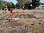
Robinson St Northampton
Northampton
Midwest
Constructed from 1912
| Type | Status | Date | Documents |
|---|---|---|---|
| Heritage List | Adopted | 15 May 2020 |
| Type | Status | Date | Documents |
|---|---|---|---|
| (no listings) |
| Type | Status | Date | Grading/Management | |
|---|---|---|---|---|
| Category | ||||
| Municipal Inventory | Adopted | 18 Nov 2005 | Category 2 | |
01911 Northampton Railway Station Precinct
| Library Id | Title | Medium | Year Of Publication |
|---|
Other Built Type
| Epoch | General | Specific |
|---|---|---|
| Original Use | Transport\Communications | Rail: Other |
This information is provided voluntarily as a public service. The information provided is made available in good faith and is derived from sources believed to be reliable and accurate. However, the information is provided solely on the basis that readers will be responsible for making their own assessment of the matters discussed herein and are advised to verify all relevant representations, statements and information.
Constructed from 1912
The sites have high local significance historically and socially and the trees and weighbridge are important surviving reminders of the activity previously associated with the place.
This is the former site of bulk wheat / grain handling adjacent to the old railway precinct in Northampton. The site is identified in Robinson Street by a row of Morton Bay Figs and Pepper trees that line the front of the old site. The original cast iron set of scales, and the timber weighbridge deck (set into a concrete platform) are all that remains on the site of the former wheat bins. The wheat bins have been relocated onto the southern outskirts of town adjacent to the highway and more accessible for road transport (see Site No. 140). The Northampton hospital is now located on the site that was part of the railway reserve. The weighbridge can be found behind the hospital to the north where there is also a large cleared, gravel paved area which was probably the actual bin site. At the front of the hospital site, on the corner of Robinson and Stephen Streets, the concrete remains of the old railway turntable can be found.
Although work on the State's first government railway line between Geraldton and Northampton commenced in 1874 it was not opened for traffic until 1879. One of the main purposes of the line was to transport lead and copper from the Northampton Mineral Field to the port at Geraldton. The first railway station at Northampton was located further south at Gwalla (Site No.134). However following the extension of the line to Ajana, the station was relocated to a more central position in 1912. The weighbridge and turntable were possibley built then, although it may have been later with the change from bags, measured in bushels, to bulk handling by weight. The site, identified now by the old weighbridge, would most likely have seen the handling originally of wheat in bags before the construction of the old corrugated iron CBH bulk bins in 1936. The wheat bins were constructed to protect the grain awaiting transportation to the port at Geraldton. Later these were replaced by new bins to facilitate road transport, and located on the western outskirts of town (Site No.140). Chronology Entries 1936 The first CBH bin with a 1100 tonne capacity was built in Northampton. 1957 The Geraldton-Northampton-Ajana Railway was closed, the last train ran on 29 April. 1962 The Geraldton-Northampton railway line was removed. Source Pages Geraldton Guardian
Orig'l Fabric: ruins.
Ruin
| Owner | Category |
|---|---|
| DOLA | State Gov't |
This information is provided voluntarily as a public service. The information provided is made available in good faith and is derived from sources believed to be reliable and accurate. However, the information is provided solely on the basis that readers will be responsible for making their own assessment of the matters discussed herein and are advised to verify all relevant representations, statements and information.
Warribanno Chimney Rd Northampton
North of Rd
Northampton
Midwest
Constructed from 1850
| Type | Status | Date | Documents |
|---|---|---|---|
| Heritage List | Adopted | 15 May 2020 |
| Type | Status | Date | Documents |
|---|---|---|---|
| (no listings) |
| Type | Status | Date | Grading/Management | |
|---|---|---|---|---|
| Category | ||||
| Municipal Inventory | Adopted | 19 Apr 1996 | Category 1A | |
03455 Geraldine Lead Mine Site
Individual Building or Group
| Epoch | General | Specific |
|---|---|---|
| Original Use | RESIDENTIAL | Single storey residence |
| Type | General | Specific |
|---|---|---|
| Wall | STONE | Local Stone |
This information is provided voluntarily as a public service. The information provided is made available in good faith and is derived from sources believed to be reliable and accurate. However, the information is provided solely on the basis that readers will be responsible for making their own assessment of the matters discussed herein and are advised to verify all relevant representations, statements and information.
Constructed from 1850
The homestead and graveyard has historic significance for its associations with the Geraldine Mine and early pastoral development of the district. The Kilally buildings warrant a highest level of protection under the Municipal Inventory, and consideration for entry onto the State Register by reason of its significance to the Geraldine Mine area (Site 7). Steps need to be taken to prevent further deterioration of the stone walls by wandering stock. Interpretive signs may help with the understanding of the significance of the place and discourage damage by sightseers
The Kilally buildings site is several hundred metres north of the Geraldine Mine (Site No.7) on the banks of the Murchison River. All that remains are some of the internal and external stone wall ruins of the house and several outbuildings. Sufficient remains to roughly identify the room layout and uses in some cases. The house ruins are located in a small paddock fenced with low stone walls. Further north of these, another stone wall encloses the cemetery with still clearly marked graves. There are at least 17 graves located here, most date from the 1800s, although 2 are for men killed in mining accidents in the 1920s. Damage is being caused to the stone walls by stock, vegetation growth and uncontrolled access.
It is generally understood that the Kilally Homestead was part of the Geraldine mining settlement. Indeed it is believed to have been the various Mine Managers residence, including Samuel Mitchell. The small stone walled paddock was used for horses and stock.
| Ref ID No | Ref Name | Ref Source | Ref Date |
|---|---|---|---|
| Porter,B., "Pure Galena, A story of settlement in the Australian outback.". pp30, 119. | Publicit | 2001 | |
| Lowrie, J., "Tales about Coolalley at the Geraldine Mine Site and The Warribano Chimney." |
This information is provided voluntarily as a public service. The information provided is made available in good faith and is derived from sources believed to be reliable and accurate. However, the information is provided solely on the basis that readers will be responsible for making their own assessment of the matters discussed herein and are advised to verify all relevant representations, statements and information.
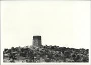
Warribanno Chimney Rd Northampton
Warribanno Chimney
Northampton
Midwest
Constructed from 1849
| Type | Status | Date | Documents |
|---|---|---|---|
| Heritage List | Adopted | 15 May 2020 | |
| State Register | Registered | 13 Dec 1996 | HCWebsite.Listing+ListingDocument, HCWebsite.Listing+ListingDocument |
| Type | Status | Date | Documents |
|---|---|---|---|
| (no listings) |
| Type | Status | Date | Grading/Management | |
|---|---|---|---|---|
| Category | ||||
| Classified by the National Trust | Classified | 11 Jun 1973 | ||
| Register of the National Estate | Permanent | 21 Mar 1978 | ||
| Classified by the National Trust | Classified {Lscpe} | |||
| Municipal Inventory | Adopted | 19 Apr 1996 | Category 1A | |
15875 Galena Heritage Area
| Name | Type | Year From | Year To |
|---|---|---|---|
| Denis Cumming | Architect | - | - |
| Library Id | Title | Medium | Year Of Publication |
|---|---|---|---|
| 1657 | Warribanno Lead Smelter Complex: conservation plan. | Heritage Study {Cons'n Plan} | 1995 |
| 6322 | The technology of colonial ore processing in Western Australia : the Warribanno Lead Smelter. | Journal article | 1997 |
| 1693 | Final report CIP grant 95/96 Chiverton House/Warribanno | Report | 1996 |
Individual Building or Group
| Epoch | General | Specific |
|---|---|---|
| Present Use | VACANT\UNUSED | Vacant\Unused |
| Original Use | INDUSTRIAL\MANUFACTURING | Refinery or Smelter |
| Style |
|---|
| Other Style |
| Type | General | Specific |
|---|---|---|
| Wall | STONE | Local Stone |
| Wall | BRICK | Common Brick |
| General | Specific |
|---|---|
| OCCUPATIONS | Mining {incl. mineral processing} |
| DEMOGRAPHIC SETTLEMENT & MOBILITY | Resource exploitation & depletion |
| DEMOGRAPHIC SETTLEMENT & MOBILITY | Settlements |
| DEMOGRAPHIC SETTLEMENT & MOBILITY | Exploration & surveying |
This information is provided voluntarily as a public service. The information provided is made available in good faith and is derived from sources believed to be reliable and accurate. However, the information is provided solely on the basis that readers will be responsible for making their own assessment of the matters discussed herein and are advised to verify all relevant representations, statements and information.
Constructed from 1851
1993 The Warribanno Chimney and smelter have very high significance historically for their associations with mining in the district and as some of the earliest secondary industry in the State. They also have high social significance for the impact flourishing mining had on the growth of the Northampton district, towns and peoples lives. Scientifically it is also of great significance demonstrating early specialist smelting techniques. Finally, the chimney has aesthetic significance in itself as an attractive and powerful icon of the mining industry and as an outstanding man-made element in sweeping landscape. 2004 Warribanno Smelter Complex Ruin comprising roasting furnace, reverberatory furnaces, blacksmith's shop, surface flue system, vertical flue shaft/chimney, tunnel flue, 'ruins one and two', all in a ruined condition, together with stone boundary cairns (c. 1849), quarry, and associated landscape and vegetation, has cultural heritage significance for the following reasons: •the place is closely associated with the Geraldine Lead Mine, situated approximately 5 kilometres northeast, which was the earliest European settlement of the mid-west of Western Australia; •the place is the oldest identified European mining site in Western Australia and is historically linked with the development of the Geraldine Lead Mine, Lynton Convict Hiring Depot and Port Gregory; •it is the oldest surviving smelter in Western Australia and one of the earliest in Australia; •it is an important demonstration of mid-nineteenth century smelting processes and technology; •it has important associations with historical figures, including Augustus Gregory, Henry Gregory and Francis Pearson; •the chimney has been a significant and valued landmark in the region since 1854; and, •the site is highly valued by the community of the mid-west region, •both for its landmark status and as a memorial to the early mining •activity and mining communities of the region.
1993 Ruins of the stone and brick chimney and vertical stone lined shaft remain on top of the hill which has spectacular views of the surrounding countryside. Vents, strategically placed on the side of the hill below the chimney to catch prevailing breezes to aid in the smelting, are identifiable along with races for molten lead and ruins of stone buildings. All are obviously the remnants of a smelter process however the detail of exactly what they represent is not apparent to the unqualified observer. Stone ruins in the paddock adjoining the chimney site appear to be related either as administrative or residential accommodation associated with the smelter. Remnants of the tramway constructed to bring ore from the Geraldine Mine (Site 7) and Galena Mine (Site 6) can be found in the surrounding bush. From the Northwest Coastal Highway follow the Kalbarri road for about 8km, thence north for 8km to the chimney turnoff. For a detailed discussion of the physical evidence, refer to the Conservation Plan by Considine and Griffiths Architects Pty Ltd: 'Warribanno Lead Smelter Complex, Conservation and Management Plan' (prepared for the Northampton Historical Society Inc. Property Management Committee, October 1995). 2004 Ruins of the stone and brick chimney and vertical stone lined shaft remain on top of the hill which has spectacular views of the surrounding countryside (see photos Warribanno NR009 to NR009-3). Vents, strategically placed on the side of the hill below the chimney to catch prevailing breezes to aid in the smelting, are identifiable along with races for molten lead and ruins of stone buildings. All are obviously the remnants of a smelter process; however, the detail of exactly what they represent is not apparent to the unqualified observer. Stone ruins in the paddock adjoining the chimney site appear to be related either as administrative or residential accommodation associated with the smelter. Remnants of the tramway constructed to bring ore from the Geraldine Mine (Site 7) and Galena Mine (Site 6) can be found in the surrounding bush.
1993 At the beginning of 1851 the Geraldine Mining Company made inquiries as to the possibility of building a smelter near the mine site. Francis W. Pearson, who had experience in both lead and copper smelting from his work at Newcastle-on-Tyne, was selected to build the smelter. He arrived at the Geraldine with his wife and family in November 1851 and in doing so the Pearsons became the first family settlers at the mine. Indeed, Mrs Pearson is thought to have been the first white woman to come and live permanently in the district. The family lived in a small stone and clay cottage with a thatched roof near the mine site. Completed several months later, the smelter was constructed approx 2 miles south of the Geraldine Mine. It was built into a hill so that the body of the hill could act as an oven. At the base of the chimney a large opening faced the direction of the prevailing westerlies, thus creating a natural bellows. Ore and wood fuel were thrown into the cavern and fired, causing the molten lead to flow out from an opening at the bottom and down a bricked channel, where it cooled and was loaded into small trucks on a very narrow gauge railway. Bricks for the structure are believed to have been brought out from England. The first lead ingots were exported via Port Gregory in 1853. The chimney was originally about 50ft (12m) high. Figures for the export of lead indicate that the smelter worked principally between 1853 & 1859, and produced about 577 tons of lead. In 1979, the National Trust undertook conservation works on the site through the Geraldton Building Company. It is claimed to be the first smelter in Western Australia. M.A. Bain claims that the name is derived from the aboriginal word "Warri-Bunna" meaning fire hill. This name was recorded in the late 1860's by Surveyor Phelps; the hill was possibly named after the smelter went into operation. 2004 For a detailed discussion of the documentary evidence, refer to the Conservation Plan by Considine and Griffiths Architects Pty Ltd: 'Warribanno Lead Smelter Complex, Conservation and Management Plan' (prepared for the Northampton Historical Society Inc. Property Management Committee, October 1995). At the beginning of 1851 the Geraldine Mining Company made inquiries as to the possibility of building a smelter near the mine site. Francis W. Pearson, who had experience in both lead and copper smelting from his work at Newcastle-on-Tyne, was selected to build the smelter. He arrived at the Geraldine with his wife and family in November 1851 and in doing so the Pearsons became the first family settlers at the mine. Indeed, Mrs Pearson is thought to have been the first white woman to come and live permanently in the district. The family lived in a small stone and clay cottage with a thatched roof near the mine site. Completed several months later, the smelter was constructed approx 2 miles south of the Geraldine Mine. It was built into a hill so that the body of the hill could act as an oven. At the base of the chimney a large opening faced the direction of the prevailing westerlies, thus creating a natural bellows. Ore and wood fuel were thrown into the cavern and fired, causing the molten lead to flow out from an opening at the bottom and down a bricked channel, where it cooled and was loaded into small trucks on a very narrow gauge railway. Bricks for the structure are believed to have been brought out from England. The first lead ingots were exported via Port Gregory in 1853. The chimney was originally about 50ft (12m) high. Figures for the export of lead indicate that the smelter worked principally between 1853 & 1859, and produced about 577 tons of lead. In 1979, the National Trust undertook conservation works on the site through the Geraldton Building Company. It is claimed to be the first smelter in Western Australia. M.A. Bain claims that the name is derived from the aboriginal word "Warri-Bunna" meaning fire hill. This name was recorded in the late 1860's by Surveyor Phelps; the hill was possibly named after the smelter went into operation. Chronology Entries 1851 Francis Pearson, a smelter tradesman, his wife Mary Anne and their family settled near the Geraldine Mine area. For the next five years, the Pearsons were the only European family living in the locality. Pearson built the smelters to service the Geraldine Mine. The Warribanno Chimney was completed. Source Ancient Landmarks, Bain, M. A., UWA Press, Perth, 1975 ISBN:0 85564 090 1 page: 95
Integrity: Medium Modifications: Dismantled Smelter Orig'l Fabric: The main part of the chimney has collapsed or been removed.
| Ref ID No | Ref Name | Ref Source | Ref Date |
|---|---|---|---|
| Cumming, D.A; " Preliminary Notes on the Northampton Mineral Field". | 1994 | ||
| Considine and Griffiths Architects; "Warribanno Lead Smelter Complex, Conservation and Management Plan. | Northampton Historical Society Inc. | 1995 | |
| Suba, T; "The Thematic History of the Town of Northampton" p.29 | Shire of Northampton | 1993 | |
| Bain, M.; "Ancient Landmarks". | 1975 | ||
| Considine and Griffiths Architects Pty Ltd (2) and Fiona Bush Archaeologist; "Galena Conservation Plan". | Galena Management Committee. | 1998 | |
| Galena Management Plan Steering Committee; "Galena Mining Heritage Area Management Plan". | Shire of Northampton. | 2000 |
This information is provided voluntarily as a public service. The information provided is made available in good faith and is derived from sources believed to be reliable and accurate. However, the information is provided solely on the basis that readers will be responsible for making their own assessment of the matters discussed herein and are advised to verify all relevant representations, statements and information.
About 5 km from the Geraldine Mine. Built here because of availability of wood and on road from mine to Port Gregory. Height of chimney (originally) 105 f. Made of brick & stone. The system employed was to puid the chimney on the peak of the hill and then bore a hole through the hill itself with a right angled turn near the bottom of the hill where the rail track ended. The lead ore and brushwood was fed into the top and aided by the forced draft through the bottom produced enough heat to melt the galena, the piglead then flowed to the bottom and, on cooling, was loaded onto the rail trucks. The heat generated can be evidenced by the melted fire bricks which can be seen on the site. It has been claimed to be the first smelter in Western Australia.
Assessment 1973 Construction 1853 Builder: F. W. Pearson
This information is provided voluntarily as a public service. The information provided is made available in good faith and is derived from sources believed to be reliable and accurate. However, the information is provided solely on the basis that readers will be responsible for making their own assessment of the matters discussed herein and are advised to verify all relevant representations, statements and information.
Wundi Rd Northampton
Near Wundi Well
Northampton
Midwest
Constructed from 1920
| Type | Status | Date | Documents |
|---|---|---|---|
| (no listings) |
| Type | Status | Date | Documents |
|---|---|---|---|
| (no listings) |
| Type | Status | Date | Grading/Management | |
|---|---|---|---|---|
| Category | ||||
| Municipal Inventory | Adopted | 19 Apr 1996 | Category 3 | |
08922 Brookside, Hillview & Surrounds
Individual Building or Group
| Epoch | General | Specific |
|---|---|---|
| Present Use | FARMING\PASTORAL | Shed or Barn |
| Original Use | RESIDENTIAL | Single storey residence |
| Type | General | Specific |
|---|---|---|
| Wall | EARTH | Adobe {Mud Brick} |
| Roof | METAL | Corrugated Iron |
| General | Specific |
|---|---|
| OCCUPATIONS | Grazing, pastoralism & dairying |
| DEMOGRAPHIC SETTLEMENT & MOBILITY | Settlements |
This information is provided voluntarily as a public service. The information provided is made available in good faith and is derived from sources believed to be reliable and accurate. However, the information is provided solely on the basis that readers will be responsible for making their own assessment of the matters discussed herein and are advised to verify all relevant representations, statements and information.
Constructed from 1920
The Hillview mud brick building is of historic and scientific significance as a late example of this type of construction and because of the possibility of revealing something of the construction techniques used, which can often only be observed in older, badly deteriorated examples.
The rectangular, mud brick building is starting to deteriorate with exposure of the walls to the elements. The building has been re-roofed in recent times but the walls suffer from lack of protection as there is very little overhang. With better protection the life of the building could easily be extended for it has not deteriorated yet to the point of no return. Some walls have been rendered at an earlier time however the resulting moisture trapped in walls could be a problem. For a building of this period (if c1920 is accurate) it is a very late example of mud brick construction and closer examination may reveal something of techniques used.
Integrity: Low Orig'l Fabric: Intact but deteriorating
Poor
This information is provided voluntarily as a public service. The information provided is made available in good faith and is derived from sources believed to be reliable and accurate. However, the information is provided solely on the basis that readers will be responsible for making their own assessment of the matters discussed herein and are advised to verify all relevant representations, statements and information.
Hampton Road Northampton townsite
North West Coastal Hwy, at the N boundary of
Wannerenooka
Northampton
Midwest
Constructed from 1855, Constructed from 1958
| Type | Status | Date | Documents |
|---|---|---|---|
| Heritage List | Adopted | 15 May 2020 | |
| State Register | Registered | 01 Apr 1999 | HCWebsite.Listing+ListingDocument, HCWebsite.Listing+ListingDocument |
| Type | Status | Date | Documents |
|---|---|---|---|
| (no listings) |
| Type | Status | Date | Grading/Management | |
|---|---|---|---|---|
| Category | ||||
| Municipal Inventory | Adopted | 19 Apr 1996 | Category 1A | |
| Library Id | Title | Medium | Year Of Publication |
|---|---|---|---|
| 1425 | Historic Wanerenooka Mine Precinct: Conservation Report | Report | 1996 |
| 1476 | Historic Wanerenooka Mine Precinct: Conservation Report | Report | 1996 |
| 11569 | Landscapes of Redemption: Tracing the path of a Convict Miner in Western Australia | Heritage Study {Other} | 2010 |
Historic Site
| Epoch | General | Specific |
|---|---|---|
| Present Use | VACANT\UNUSED | Vacant\Unused |
| Original Use | MINING | Mining Battery |
| Style |
|---|
| Vernacular |
| General | Specific |
|---|---|
| DEMOGRAPHIC SETTLEMENT & MOBILITY | Resource exploitation & depletion |
| PEOPLE | Famous & infamous people |
| OCCUPATIONS | Mining {incl. mineral processing} |
This information is provided voluntarily as a public service. The information provided is made available in good faith and is derived from sources believed to be reliable and accurate. However, the information is provided solely on the basis that readers will be responsible for making their own assessment of the matters discussed herein and are advised to verify all relevant representations, statements and information.
Constructed from 1855
Wanerenooka Mine Site, a series of archaeological sites comprising the remains of an early rural industrial complex and settlement, has cultural heritage significance for the following reasons: •the place is the second oldest copper mine, and possibly the third oldest mine, in Western Australia; •the Warenenooka mine community was the first European settlement in the Northampton area; •the place provides an important demonstration of the nature and organisation of early frontier mining communities; •the place is closely associated with Joseph Lucas Horrocks, former convict and local philanthropist; •the shafts, structural remains and archaeological deposits have high scientific value as demonstrations of early mining techniques and Midwest vernacular architecture, and for their potential to provide archaeological evidence of the life of the miners and their families during the period 1856-1868; •the place has social value to the local community as the originalsettlement from which the town of Northampton developed; and, •the place contains Aboriginal sites which appear to date from the early period of contact with Europeans.
Site and ruins of what is believed to be the first copper mine in WA, (discovered 1855, operable 1856). Some remnants of stone walls of buildings on higher part of site and extensive mine workings on the lower ground below the Water Authority installations. "The site contains a natural spring that is of some significance to the aboriginal community. It also contains remains of explosives magazines, footings and walls, mine shafts, slag dumps and the like, which to the tutored eye, give an indication of the settlement and workings nature." (Considine and Griffith, Northampton Town Planning Scheme Policies.)
For full details of the history see the Heritage Council Register assessment documentation and Considine and Griffiths 1996. The first of the great copper mines on the Northampton Mineral Field following discovery of copper in 1855, the Wanerenooka, was opened by the Western Australian Mining Association early in 1856. [Not in 1842; it is commonly held that copper was first found here in 1842 by a shepherd who is reported to have parted with whatever rights he had on the property for 100 pounds - however there is no evidence to confirm this story.] Fremantle merchant Lionel Samson was the Chairman of the Association while Luke Leake and Thomas Burges were Directors. During the first ten years of its operations the mine produced ore to the value of £40,000. An outstanding copper mine in its day, the Wanerenooka was dewatered in 1957 and small amounts of copper and lead ore were raised. The town of Northampton emerged in 1864 from the two separate communities which sprang up around the two original and major copper mines in the district - the Wanerenooka and Gwalla Mines. The spring is believed to have been an aboriginal watering point. Chronology Entries 1855 Copper was discovered at Wanerenooka Hill. 36.5ha of land was purchased and the Waranenooka Copper Mine was established. 1855 Joseph Horrocks resigned his post at the Port Gregory Hiring Station and opened a store at Wanerenooka. He was also a member of the syndicate which opened the copper mine.
Integrity: Low Orig'l Fabric: Ruins
Poor
| Ref ID No | Ref Name | Ref Source | Ref Date |
|---|---|---|---|
| Gibbs, M; "An Archaeological Survey and Assessment of the Gwalla and Wanerenooka Mine Precincts, Northampton, Western Australia." | Shire of Northampton | 1994 | |
| Feilman (119), Palassis (27), Kelly, G.J; "The History of Mining in the Geraldton District", Early Days, Vol. 6, No. 1, p.83 | 1962 | ||
| Considine and Griffiths Architects Pty Ltd in conjunction with Palassis Architects; "Historic Wanerenooka Mine Precinct Conservation Report." | Shire of Northampton | 1996 |
| Owner | Category |
|---|---|
| Shire of Northampton | Local Gov't |
This information is provided voluntarily as a public service. The information provided is made available in good faith and is derived from sources believed to be reliable and accurate. However, the information is provided solely on the basis that readers will be responsible for making their own assessment of the matters discussed herein and are advised to verify all relevant representations, statements and information.

1512 Horrocks Rd Sandy Gully
18 km from Northampton on Horrocks Rd. Adjacent to Bowes River, near Sandy Gully.
Willi Gulli
Willow Gully Homestead and Outbuildings
Northampton
Midwest
Constructed from 1860
| Type | Status | Date | Documents |
|---|---|---|---|
| Heritage List | Adopted | 15 May 2020 | |
| State Register | Registered | 28 Jun 1996 | HCWebsite.Listing+ListingDocument, HCWebsite.Listing+ListingDocument |
| Type | Status | Date | Documents |
|---|---|---|---|
| (no listings) |
| Type | Status | Date | Grading/Management | |
|---|---|---|---|---|
| Category | ||||
| Municipal Inventory | Adopted | 19 Apr 1996 | Category 1A | |
| Classified by the National Trust | Classified | 06 Dec 1982 | ||
| Register of the National Estate | Interim | 28 May 1996 | ||
| Aboriginal Heritage Sites Register | Registered | 24 Jun 1997 | ||
| Library Id | Title | Medium | Year Of Publication |
|---|---|---|---|
| 5753 | Homesteads of the mid west region of Western Australia. | Book | 1997 |
| 3445 | Willow Gully - Conservation Works to Mural Heritage Grants Program 1997/8 Final Report | Report | 1998 |
| 621 | Four homesteads: Oakabella, the Bowes (Knockbrack),Willi Gulli and Trevenson, Northampton District. | Heritage Study {Other} | 1995 |
| 8074 | Willow Gully, Northampton : conservation plan. | Heritage Study {Cons'n Plan} | 2006 |
| 5921 | Off-shears : the story of shearing sheds in Western Australia. | Book | 2002 |
| 4601 | Heritage Grants Program : final report : Willow Gully : June 2000. | Report | 2000 |
| 7622 | Willow Gully stone walls conservation works : Final Conservation Works Report : Grant Allocatin No 195/504 2004/2005. | Conservation works report | 2006 |
Individual Building or Group
| Epoch | General | Specific |
|---|---|---|
| Present Use | RESIDENTIAL | Single storey residence |
| Original Use | FARMING\PASTORAL | Other |
| Original Use | FARMING\PASTORAL | Homestead |
| Style |
|---|
| Vernacular |
| Type | General | Specific |
|---|---|---|
| Roof | METAL | Corrugated Iron |
| Wall | STONE | Local Stone |
| General | Specific |
|---|---|
| DEMOGRAPHIC SETTLEMENT & MOBILITY | Settlements |
| OCCUPATIONS | Grazing, pastoralism & dairying |
This information is provided voluntarily as a public service. The information provided is made available in good faith and is derived from sources believed to be reliable and accurate. However, the information is provided solely on the basis that readers will be responsible for making their own assessment of the matters discussed herein and are advised to verify all relevant representations, statements and information.
One of the oldest properties in the area, a complex of stone buildings ranking with Berkshire Valley and Burges' Bowes stations for their constructional interest, and like Bowes probably built by Ticket of Leave men. The stone fences outside the stone staircase are particularly notable, The setting is picturesque with the tree-lined Bowes River in its narrow valley nearby.
The original cottage and present house are of local limestone with shingles under the corrugated iron roof, the garden at the front of the house being enclosed with a stone wall. Both this wall and the one extending from the outbuilding marked 3 on the plan are about a metre high and 23 cms thick. At several places, steps were erected on each side to allow easy access. The building marked 1 has an attic formerly used as a school room and for parties and dances when entertaining. It is reached by a solid external staircase and the wooden door at the top of the stairs is original. Floors in most of the buildings ar of flat stone or rammed ants nest. Willi Gulli is the aboriginal name and is said to mean Salt Gulley. ALl the trees in the orchard which Williams planted died from the salt which seeped up from the underlying soil.
Assessment 1982 Construction: 1863 to early 1870s The property was taken up in 1863 by John Williams who had been manager for William Burges at the Bowes from 1854 to 1863 and the buildings were erected by him for the next ten years. He married Honora Morrissey of the pioneer family at Mt Erin station and the had twelve children not all of whom survived.
This information is provided voluntarily as a public service. The information provided is made available in good faith and is derived from sources believed to be reliable and accurate. However, the information is provided solely on the basis that readers will be responsible for making their own assessment of the matters discussed herein and are advised to verify all relevant representations, statements and information.
The Willi Gulli Homestead complex has aesthetic, historic and social significance within both the region and the State because of the excellent authenticity and integrity of its buildings. Its significance is strengthened for its associations with the development of the district, the pastoral industry in the State, and locally with the Williams family.
The Willi Gulli Homestead is a collection of stone farmhouse and associated farm buildings, walls and wells, all relatively intact although some deterioration has occurred. It is an excellent example of a pastoral homestead demonstrating the complexity and self sufficiency necessary to survive successfully in the industry and the environment. As a group of buildings of its type in the district (or possibly the State), it can only be compared with Oakabella for its complexity and the extent of surviving fabric. The main buildings in the group comprise the homestead, with walled front garden and rear walled orchard/dairy paddock. To the rear there is an adjacent kitchen, dining and dairy building at the south west end of the walled garden. At the west end of the rear walled garden are stables and adjoining the homestead is a two storey barn with workshops or storerooms below. Other buildings have also been added in this vicinity and adapted periodically. More recently this building has been used for ablutions, laundry, generator and general storage as an adjunct to the homestead. Further to the north of the two storey barn is a separate 3 roomed rectangular building. Anecdotal evidence from the current owners suggests it could have been the original homestead and was later used as staff quarters, blacksmith shop and stores. On the east of this building is another (third) walled garden/orchard or animal yard running up towards the main road and a more recent corrugated iron, shearing shed, thought to be c1959 built by Gus Hosken [Source: A. Sellers], The homestead itself has a simple plan form, similar to others in the district (said to be based on the Bowes model, (see Site No.141), with the rooms all adjacent in a long row with no interconnecting doors, but with an access verandah down both long sides (east and west). On the front (east), the verandah ends have been enclosed, either originally or very early on, with masonry. The rear verandah has been enclosed with timber studwork and sheet asbestos on the west, possibly for weather control as well as providing covered, internal access. All the buildings are stone however, over time, the homestead walls have been cement rendered. This was probably an attempt to control damp but has only caused the stone walls to fret and deteriorate. The present owners are currently removing the render and concrete and restoring the original stone work. The three main rooms and verandahs have concrete floors which may have replaced original floor finishes. The concrete may be adding to deterioration of walls by trapping moisture. Recently the concrete floors to verandas has been broken back and removed along the walls to allow them to breathe and ultimately all concrete against walls should be removed. The separate dining/kitchen building has been cement rendered and the render may have to be removed and restored to arrest the deterioration that is occurring. The dairy room, where cheeses were made and stored is of particular interest in terms of the day to day activities and self sufficiency of homestead life. The stables at the bottom of the rear walled yard have the roof and walls collapsing and are in urgent need of repair or stabilisation. The collection of buildings to the north of the homestead, comprising two storey barn, laundry, storerooms and the separate staff quarters, cum original homestead, all need further investigation and study as does the whole complex.
Willi Gulli was originally part of William Burges' lease - The Bowes (Site No.141). However, in the late 1850s Mr John Williams, who was a former overseer for Burges, took it up as a separate run, of which the lease was granted in 1861. The property is situated on the Bowes River near Sandy Gully, three miles from the coast. The Willi Gulli homestead and outbuildings were built during the 1860s to house the growing Williams family. It is thought (anecdotal) that the local stone used to build the homestead was quarried by ticket-of-leave men from the Lynton Hiring Station (Site No.25). They were employed to build the house, cottages, barns, servants' quarters, stables and walled gardens. The property was broken up in the early 1900s following the non-renewal of pastoral leases resulting from the Agricultural Purchase Land Act of 1896. The Williams family bought the homestead block, while family members purchased farms that were previously part of the pastoral lease, such as Sylvan Vale, Eastbrook, Inga Vale, Sheppy Farm and Riverdew. The homestead block remained in the Williams family until 1927 when it was sold to Morrissey Brothers of Munbinia Station Yalgoo. The property was later purchased by Mr Arthur Johnson. (Lyn Diepeveen, Northampton Historical Society)
Integrity: High Modifications: Fibro verandah enclosures Orig'l Fabric: Mostly intact
Good
| Ref ID No | Ref Name | Ref Source | Ref Date |
|---|---|---|---|
| "Restoration is labour of love" | Geraldton Guardian | 5/02/1996 | |
| Considine & Griffiths; "The Four Homesteads". | 1994 | ||
| "Bush Retreat stripping back layers of time". | Geraldton Guardian | 08/06/1998. | |
| Feilman & Associates, "A Survey of Places of Historic and Landscape Significance in Northampton, Dongara, Geraldton, WA". | 1977 | ||
| BL Acc 816 B/B 511 | Photograph; "Willow Gully". | 1929 |
This information is provided voluntarily as a public service. The information provided is made available in good faith and is derived from sources believed to be reliable and accurate. However, the information is provided solely on the basis that readers will be responsible for making their own assessment of the matters discussed herein and are advised to verify all relevant representations, statements and information.
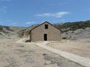
Henderson Tce off Port Gregory Rd Yallabatharra
off Port Gregory Road - INCLUDES Sanford House
Port Gregory Hiring Station/Depot
Sanford House
Northampton
Midwest
Constructed from 1853 to 1856
| Type | Status | Date | Documents |
|---|---|---|---|
| Heritage List | Adopted | 15 May 2020 | |
| State Register | Registered | 02 Jun 1995 | HCWebsite.Listing+ListingDocument, HCWebsite.Listing+ListingDocument |
| Type | Status | Date | Documents |
|---|---|---|---|
| (no listings) |
| Type | Status | Date | Grading/Management | |
|---|---|---|---|---|
| Category | ||||
| Municipal Inventory | Adopted | 19 Apr 1996 | Category 1A | |
| Aboriginal Heritage Sites Register | Permanent | |||
| Register of the National Estate | Permanent | 26 Mar 1985 | ||
| Classified by the National Trust | Classified | 06 Mar 1984 | ||
| Library Id | Title | Medium | Year Of Publication |
|---|---|---|---|
| 8474 | Building a colony: the convict legacy. | Book | 2006 |
| 4250 | Lynton Convict Hiring Depot-Depot Building Port Gregory Conservation Works: Final Report | Heritage Study {Other} | 1999 |
| 2491 | An archaeological study of the Lynton convict hiring depot. | Report | 1993 |
| 5592 | Sanford House : conservation works (final report). | Conservation works report | 2002 |
| 11815 | Henderson & Coy : Royal Engineers & the Convict Establishment Fremantle Western Australia 1850 - 1872 | Book | 2017 |
| 11734 | Lynton: a study of the convict hiring depot | Heritage Study {Other} | 1982 |
| 11569 | Landscapes of Redemption: Tracing the path of a Convict Miner in Western Australia | Heritage Study {Other} | 2010 |
| 7946 | Port Gregory convict hiring depot, lockup. Final conservation works report - grant allocation 2004/2005. Job number 05147 | Conservation works report | 2005 |
| 6426 | A preliminary study of convict sites in Western Australia (draft). | Heritage Study {Other} | 1997 |
| 5959 | Mrs Mulder's trough; Konnongoring Hall; Perenjori; Hawes, Mullewa; Lynton Heritage Site; Hassell Homestead. | Video | 1991 |
| 5753 | Homesteads of the mid west region of Western Australia. | Book | 1997 |
| 3911 | Lynton Heritage Structural Report on Stables, Depot and Lockup-Prepared for RW & SF Simkin | Heritage Study {Other} | 1999 |
| 3037 | Lynton Conservation Works - Final Report | Heritage Study {Other} | 1993 |
| 5130 | Lynton Heritage : conservation plan / by Considine and Griffiths Architects Pty Ltd. | Heritage Study {Cons'n Plan} | 1996 |
Individual Building or Group
| Epoch | General | Specific |
|---|---|---|
| Original Use | GOVERNMENTAL | Gaol |
| Present Use | VACANT\UNUSED | Vacant\Unused |
| Type | General | Specific |
|---|---|---|
| Wall | STONE | Limestone |
| General | Specific |
|---|---|
| DEMOGRAPHIC SETTLEMENT & MOBILITY | Workers {incl. Aboriginal, convict} |
This information is provided voluntarily as a public service. The information provided is made available in good faith and is derived from sources believed to be reliable and accurate. However, the information is provided solely on the basis that readers will be responsible for making their own assessment of the matters discussed herein and are advised to verify all relevant representations, statements and information.
Both Lynton Convict Depot and Lynton Station are located on the east side of Hutt Lagoon, several kilometres .inland of the fishing village of Port Gregory. The convict depot itself is adjacent to the main access road to Port Gregory, while the original station buildings are several hundred metres north (along 'Henderson Terrace'), on the hillside beside the modern station. In 1852 it was decided to establish a Convict Depot and Port·Gregory. Convicts were already being employed in Geraldine, and Port Gregory was the point of export. There was also a steady development of the pastoral industry in the area which was in need of labour. On 22nd May 1853 a party of 60 men with a Pensioner Guard arrived and set up a tent camp. In charge was Convict Establishment Senior Assistant Supervisor Captain H A Sanford, who immediately set about building a permanent depot. First priority was a residence for the Supervisor which was finished within the year. The remainder of the depot, including barracks, hospital, cookhouse, pr1v1es, officers' and wardens' quarters and lock-up was substantially completed by 1856. Stone was quarried on the site, lime was burnt for mortar. the source of the time in floors and roofs is not known. Wooden shingles covered the roofs; what remains of the joinery is of good design and quality. However, just as the work was completed, the government decided to close down the system of out-stations, and the depot was abandoned in 1857. The residence, granary and store were maintained as the central building to the Lynton estate which was developed by Sanford after the convicts left. The house remained in use until the 1940s and is now a substantial ruin. The granary has been partially restored,and the store is still in effective use as a farm shed. The remains of the depot can only be described as an archaeological site with one cottage still intact, a few walls of other buildings still standing, the foundations of the rest disappearing into the grass . These ruins were surveyed in 1982, and the maps and descriptions from that survey are the reference for the extent of the classification now proposed. It is also clear that considerable deterioration has occurred since then.
Assessment 1991 Construction c. 1856
This information is provided voluntarily as a public service. The information provided is made available in good faith and is derived from sources believed to be reliable and accurate. However, the information is provided solely on the basis that readers will be responsible for making their own assessment of the matters discussed herein and are advised to verify all relevant representations, statements and information.
Constructed from 1857, Constructed from 1853
The ruins of the convict hiring depot at Lynton have very high historic and social significance for the district and the State for their associations with convicts/ticket-of-leave men and the development of Port Gregory, the Geraldine Mine and surrounding districts. The convict depot is one of the few physical remnants of the convict era left in the State.
The limestone ruins of the Lynton convict hiring depot complex sit in a small valley near the coast at Port Gregory. Enough of the original fabric of two main buildings remains to gain some understanding of the place. The convict lockup building, with its holding cells, high perimeter, gable end walls and walled exercise yard, sits further up the valley than the other obvious ruins of the depot building. After the lockup building, the depot/hiring building is the most complete. Of the several other support buildings around the main depot most have largely disappeared or remain as piles of rubble or low walls. Interpretive signs, illustrating the layout of the complex, would help with an understanding of the place. 2004/05 Review: Works undertaken in late 2004 have resulted in one of the buildings being largely reconstructed and reroofed. Interpretive material has been installed.
The Lynton Hiring Depot was established in 1853, primarily to provide a labour force for the Geraldine Mine (Site No.7.) and the pastoral stations in the vicinity. On the 22 May 1853 the first ticket-of-leave men, accompanied by a detachment of Pensioner Guards to oversee them, arrived at Port Gregory on board the Leander and Gold Digger. Initially camped in tents, the construction of the stone depot buildings soon commenced but proceeded at a slow pace due to the time taken to cut limestone, lack of suitable local timber and a shortage of skilled tradesmen. The wrecking of the 'Mary Queen of Scots' in February 1855 also delayed construction as the ship was bringing a cargo of shingles to Lynton. Located in small valley near a bend on the Hutt River, the buildings included a lockup, depot building, hospital, quarters, blacksmith's shop and other associated buildings. The Lynton Hiring Depot was short lived. The isolation of the depot meant that it was a source of considerable expense for the Government. These expenses could not be justified with the sudden decline in the mining industry. In addition there were many cases of sickness owing to the salty water and poor soil which made it difficult to grow vegetables. On 3rd January 1857 the hiring depot was closed. Since then the buildings have generally remained unused and have fallen into disrepair, although farm produce has been stored in the depot building. It is said that during World War II stones were taken from the ruins to construct roads. Chronology Entries 1853 On the recommendation of Lord Grey, Secretary of State for the Colonies, a Convict Hiring Depot comprising of pensioner guards and convicts was established at Lynton, near Port Gregory, principally to build the roads to the Geraldine Mine, but also to build other roads and permanent buildings. Ticket-ofleave men worked below ground in the mines, side by side with free men as well as working as shepherds and farm hands for the settlers. 1853 Joseph Lucas Horrocks, who was convicted of forgery and had arrived at Fremantle on ilie 'Marion in 1852, moved to Lynton as a medical superintendent. Source Pages Ancient Landmarks, Bain, M. A., UWA Press, Perth, 1975 ISBN:0 85564 090 1 121 1855 Joseph Horrocks resigned his post at the Port Gregory Hiring Station and opened a store at Wanerenooka. He was also a member of the syndicate which opened the copper mine. 03/01/1857 Lynton was closed as a convict hiring depot, and the remaining pensioner guard families vacated theii" tents and moved into the stone buildings at the depot.
Integrity: Low
Poor
| Name | Type | Year From | Year To |
|---|---|---|---|
| Lt. Crossman | Architect | 1853 | - |
| Ref ID No | Ref Name | Ref Source | Ref Date |
|---|---|---|---|
| GHS3073 - | Photograph; "hiring station". | 1968 | |
| Bodycoat, R., "Lynton: A Study of the Convict Hiring Depot at Northampton, Western Australia," | Duncan, Stephen and Mercer, Architects for the Shire of Northampton, | 1982 | |
| GHS6202 | Photograph; "Lynton". | 1972 | |
| GHS3920 | Photograph; "Yard". | undated | |
| GHS0529 | Photograph; "hiring station". | 1968 | |
| GHS3068 | Photograph; "hiring station". | 1968 | |
| GHS3075 | Photograph; "hiring station". | 1968 | |
| GHS3919 | Photograph; "Cell Windows". | 1975 | |
| GHS5889 | Photograph; "hiring station". | 1940 | |
| GHS3922 | Photograph; "hiring station". | 1975 | |
| GHS6204 | Photograph; "Exercise yard". | 1981 | |
| GHS6200 | Photograph; "Cell". | 1981 | |
| GHS6203 | Photograph; "hiring station". | 1981 | |
| GHS3069 | Photograph; "Cell". | 1968 | |
| Feilman & Associates, "A Survey of Places of Historic and Landscape Significance in Northampton, Dongara, Geraldton, WA", | Feilman & Associates, | 1977 | |
| GHS2919 | Photograph; "Lynton". | 1968 | |
| GHS6630 | Photograph; "hiring station". | 1967 | |
| GHS6196 | Photograph; "Cottage". | 1972 | |
| GHS3070 | Photograph; "hiring station". | 1968 | |
| GHS7676 | Photograph; "Cell". | 1949 | |
| GHS6199 | Photograph; "hiring station". | 1981 | |
| GHS3923 | Photograph; "hiring station". | 1975 | |
| Lilley, I. & Gibbs, M. "An Archaeological Study of the Lynton Convict Hiring Depot," | National Trust of Australia (WA) | 1993 | |
| GHS6194 | Photograph; "hiring station". | 1940 | |
| Considine & Griffiths Architects Pty Ltd, "Lynton Heritage Conservation Plan," | 1996 | ||
| GHS5890 | Photograph; "Lynton". | 1944 | |
| GHS6633 | Photograph; "hiring station". | 1967 | |
| GHS3921 | Photograph; "hiring station". | 1975 | |
| GHS5202 | Photograph; "hiring station". | 1975 | |
| GHS5973 | Photograph; "hiring station". | 1948 | |
| GHS3924 | Photograph; "hiring station". | 1975 | |
| GHS6201 | Photograph; "hiring station". | 1972 | |
| GHS3072 | Photograph; "Cell Doors". | 1968 | |
| GHS5972 | Photograph; "hiring station". | 1948 |
This information is provided voluntarily as a public service. The information provided is made available in good faith and is derived from sources believed to be reliable and accurate. However, the information is provided solely on the basis that readers will be responsible for making their own assessment of the matters discussed herein and are advised to verify all relevant representations, statements and information.