Local Government
Broome
Region
Kimberley

Mangrove Pt,Town Beach Broome
MI 2004 states 85 Robinson St
Mangrove Point Jetty
Stock Jetty, Town Jetty
Broome
Kimberley
Constructed from 1896
| Type | Status | Date | Documents |
|---|---|---|---|
| (no listings) |
| Type | Status | Date | Documents |
|---|---|---|---|
| (no listings) |
| Type | Status | Date | Grading/Management | |
|---|---|---|---|---|
| Category | ||||
| Municipal Inventory | Adopted | 28 Aug 2014 | Grading B | |
| Name | Type | Year From | Year To |
|---|---|---|---|
| Public Works Dept | Architect | - | - |
Historic Site
| Epoch | General | Specific |
|---|---|---|
| Present Use | Transport\Communications | Water: Jetty |
| Original Use | Transport\Communications | Water: Jetty |
| General | Specific |
|---|---|
| TRANSPORT & COMMUNICATIONS | Rail & light rail transport |
This information is provided voluntarily as a public service. The information provided is made available in good faith and is derived from sources believed to be reliable and accurate. However, the information is provided solely on the basis that readers will be responsible for making their own assessment of the matters discussed herein and are advised to verify all relevant representations, statements and information.
Constructed from 1897
The site of Broome jetty is an important historical site representing the shipping and pearling industries that were the foundation and sustenance of settlement and development in Broome.
Embankment of stone backfill at the northeast end of Town Beach- extending out from the Pioneer Cemetery promontory, and at the south end of Roebuck Bay.
Mangrove Point Jetty was constructed in 1897 as the town jetty. It was 2,953 feet (900 metres) long and 15 feet (4.5 metres) wide, with a 'T'-shaped head 340 feet (103 metres) long and 30 feet (9 metres) wide. Contract for the structure was for £17,519. The jetty was connected to the town and to Streeter's Jetty in Chinatown, by a tramway. The line ran down the centre of the jetty and on one side was a cattle race, a box-like structure enclosed on both sides. Cattle were driven along the race to be loaded onto a waiting ship. The jetty was important for the transport of stock because of the considerable overland distance. Despite its length, boats were still left stranded at low tide. The jetty was the place to be seen when the steamships were in: master pearlers in white suits with two gold studs at the neck band and wearing pith helmets and the ladies with parasols. The steamship lounges would be open for the enjoyment of gin slings and whiskey and sodas. The jetty closed in the late 1960s, when a new deepwater port jetty was built further south. Mangrove Point remains a tourist lookout, viewing site and popular fishing spot.
Modifications: Extensive
Site Only
| Ref ID No | Ref Name | Ref Source | Ref Date |
|---|---|---|---|
| Shire of Broome's Municipal Inventory. | 1996 | ||
| Broome Historical Society |
| Reserve | Lot/Location | Plan/Diagram | Vol/Folio |
|---|---|---|---|
| 1643 | Lot 838 & 2813 |
This information is provided voluntarily as a public service. The information provided is made available in good faith and is derived from sources believed to be reliable and accurate. However, the information is provided solely on the basis that readers will be responsible for making their own assessment of the matters discussed herein and are advised to verify all relevant representations, statements and information.
McPherson St Broome
West end of St
Broome
Kimberley
| Type | Status | Date | Documents |
|---|---|---|---|
| (no listings) |
| Type | Status | Date | Documents |
|---|---|---|---|
| (no listings) |
| Type | Status | Date | Grading/Management | |
|---|---|---|---|---|
| Category | ||||
| Municipal Inventory | Adopted | 28 Aug 2014 | Grading C | |
Historic Site
| Epoch | General | Specific |
|---|---|---|
| Original Use | INDUSTRIAL\MANUFACTURING | Housing or Quarters |
| Present Use | INDUSTRIAL\MANUFACTURING | Housing or Quarters |
This information is provided voluntarily as a public service. The information provided is made available in good faith and is derived from sources believed to be reliable and accurate. However, the information is provided solely on the basis that readers will be responsible for making their own assessment of the matters discussed herein and are advised to verify all relevant representations, statements and information.
The site of the former camp has historic value for its association with the peak period of commercial activity in Broome in the first half of the 20th century when pearling was a profitable industry attracting many workers to the townsite. The site of the former camp has historic value for its association with the past practices of divisions of the community along economic, cultural and racial characteristics as the camp formerly on this site was designated for use by ‘Malays’ a loose term applied to all people of south east Asian origin.
The townsite of Broome and its community was highly stratified along racial and economic lines during the majority of the 20th century. The divisions in the groups was represented in the location and type of living accommodation. The most disadvantaged were the indigenous aboriginal people, who lived in fringe camps in appalling conditions and had the least autonomy in the community. The most advantaged were the relatively few white ‘bosses’ and their families. In between was a complex layering of social groups each with their own social systems which were brought from their own countries of origin. The ‘Malay’ workers was a catch all term for people from South-east Asia, which included contemporary Indonesia and Malaysia. The Malay men who came to Broome to work were indentured labourers and worked as general deck hands or in ancillary service trades. They were rarely divers, merchants or held positions of influence. As a result their living accommodation was generally on the fringes of the town, near the current [2019] airport, with other communities of similar status, including the mixed race population. The Malay Camp was a collection of simple cottages of corrugated iron and timber that were adapted and added to as needed. Often built on stumps to enable some cooling breezes, this small adaptation would have had little effect during the wet season as these simple shelters provided little protection from the elements. It has not been established when these simple structures were removed although there is likely to have been little need for them after the decline of the pearling industry in the 1930's and the onset of World War II and the internment of foreign nationals. Any physical evidence of the former camps is likely to have been removed during later ground works.
| Ref Number | Description |
|---|---|
| No.22 | MI Place No. |
This information is provided voluntarily as a public service. The information provided is made available in good faith and is derived from sources believed to be reliable and accurate. However, the information is provided solely on the basis that readers will be responsible for making their own assessment of the matters discussed herein and are advised to verify all relevant representations, statements and information.
Minyirr to Bindiyangan Broome
Minyirr (Gantheaume Point) to Bindiyangan (Coulomb Point) on Dampier Peninsula
Broome
Kimberley
| Type | Status | Date | Documents |
|---|---|---|---|
| Heritage List | Adopted | 27 Jun 2019 |
| Type | Status | Date | Documents |
|---|---|---|---|
| (no listings) |
| Type | Status | Date | Grading/Management | |
|---|---|---|---|---|
| Category | ||||
| Municipal Inventory | Adopted | 27 Jun 2019 | Grading B | |
Other Aboriginal Site
| General | Specific |
|---|---|
| DEMOGRAPHIC SETTLEMENT & MOBILITY | Aboriginal Occupation |
| PEOPLE | Local heroes & battlers |
| OCCUPATIONS | Hospitality industry & tourism |
| SOCIAL & CIVIC ACTIVITIES | Cultural activities |
| PEOPLE | Aboriginal people |
This information is provided voluntarily as a public service. The information provided is made available in good faith and is derived from sources believed to be reliable and accurate. However, the information is provided solely on the basis that readers will be responsible for making their own assessment of the matters discussed herein and are advised to verify all relevant representations, statements and information.
The Lurujarri Heritage Trail, an 80km coastal walking trail commencing in Broome and following the land of a traditional Song Cycle, has cultural heritage significance for the following reasons: • the trail follows the land of a traditional Song Cycle, with camping places which have been used for millennia and a number of archaeological sites which testify to the long-standing presence of Aboriginal people utilising the route for practical and cultural purposes; • the trail is associated with prominent local Law Man, the late Paddy Roe OAM, who created and promoted the heritage trail to both maintain Aboriginal cultural heritage and to further the cause of reconciliation, and who was awarded the Order of Australia Medal in recognition of his achievements; • with its spectacular scenery and substantially unmodified landscapes, the trail has outstanding aesthetic values, with a number of varying types of landscapes and opportunities for vistas; • the trail includes a number of sites of scientific interest, most notably dinosaur footprints which are claimed to be one of the world’s most important resources for further study; and, • the trail has been established for more than 25 years, and has been walked by a large number of people—both Aboriginal and non-Aboriginal—furthering an appreciation of country, leading to increased potential for reconciliation, and gaining international recognition of this Song Line.
The Lurujarri Heritage Trail is an 80km coastal walking trail, following part of a traditional song-cycle of the Jabirr Jabirr, Jukun and Ngumbarl peoples. Traditionally the trail commences at Reddell Beach (Inara) although the formal tour starts at Minyirr (Gantheaume Point) and heads north to Minarriny (Coulomb Point). Ethnographic sites on the Trail include mythological and ceremonial places relating to the song cycle, camping areas of historical significance, and numerous burials. The burials are periodically exposed and re-covered by shifting sands but the locations of only a few of these are known. There are numerous freshwater sources along the coast, both seasonal and permanent. Some of these, known as jila, are believed to have been created in the Dreamtime, locally known as Bugarrigurra. The combination of freshwater and marine and terrestrial resources made this area one of major significance to the traditional owners. The trail is offered to visitors during the winter or dry months every year. Initially the trail was offered only once a year but its popularity has increased and in 2018 was run three times. The trail typically takes nine days and the participants camp out along the route with a local team providing practical support.
Lurujarri is the Jabirr Jabirr name for the coastal dunes. The red pindan cliffs are known as yanijarri. The Jabirr Jabirr speakers are not the only group associated with this country, as the Trail covers land traditionally occupied by the Jabirr Jabirr, Ngumbarl, and Jukun speaking peoples, and in more recent times the Nyulnyul and Yawuru. Following the arrival of white settlers in the Dampier Peninsula in 1865 the knowledge of law, language and culture declined among the Aboriginal peoples through dislocation and disease. Aboriginal law and custom dictate that when a tribe is dying out the custodial care of the land must be passed over to someone demonstrating the character and capacity to be a custodian. Paddy Roe (c1912-2001) was a Nyikina man, born at Roebuck Plains Sheep Camp, who traveled extensively throughout the Kimberley as a drover and windmill repairer. In 1931, he came to Jabirr Jabirr land which was inhabited by only a few elderly people. After a period of examination, Paddy Roe was entrusted with the knowledge of the place names, songs and stories of the land and made a keeper of the law of the Jabirr Jabirr, Ngumbarl and Djugan peoples. He subsequently moved his family to the area north of Broome and established the Goolarabooloo Community. In 1987, Paddy initiated the Lurujarri Heritage Trail as a trigger to encourage the members of the Goolarabooloo community to be walking in the Country again, as had always been done; to conserve, renew and stay connected with their heritage and traditional skills. He also sought to educate non-Aboriginal people to a relationship with the land; to foster trust, friendship and empathy between the indigenous community and the wider Australian and International communities. Since 1987, the trail has been provided every year by the Goolarabooloo people providing a unique experience for Aboriginal and non-Aboriginal people. Universities, schools, local communities (Broome and from the Kimberley) and, tourists have walked the Lurujarri Trail. Each year the number of participants has increased and participation in the Lurujarri Trail is recognised by a number of academic institutions, Commonwealth, State and local governments as a valuable learning experience. The Bicentennial Commemorative program recognised the trail in 1988 as part of the WA Heritage Trail Network. The Trail has been in operation for more than 25 years, and is managed and promoted as a cultural tourism venture by the Goolarabooloo community who use the trail as a valuable learning opportunity for members of the community as they learn about the culture and laws as well as skills in tourism.
This information is provided voluntarily as a public service. The information provided is made available in good faith and is derived from sources believed to be reliable and accurate. However, the information is provided solely on the basis that readers will be responsible for making their own assessment of the matters discussed herein and are advised to verify all relevant representations, statements and information.
Napier Tce Broome
SE cnr Coghlan St
Broome
Kimberley
Constructed from 1911
| Type | Status | Date | Documents |
|---|---|---|---|
| (no listings) |
| Type | Status | Date | Documents |
|---|---|---|---|
| (no listings) |
| Type | Status | Date | Grading/Management | |
|---|---|---|---|---|
| Category | ||||
| Municipal Inventory | Adopted | 28 Aug 2014 | Grading C | |
Individual Building or Group
| Epoch | General | Specific |
|---|---|---|
| Present Use | VACANT\UNUSED | Vacant\Unused |
| Original Use | HEALTH | Hospital |
| General | Specific |
|---|---|
| SOCIAL & CIVIC ACTIVITIES | Community services & utilities |
This information is provided voluntarily as a public service. The information provided is made available in good faith and is derived from sources believed to be reliable and accurate. However, the information is provided solely on the basis that readers will be responsible for making their own assessment of the matters discussed herein and are advised to verify all relevant representations, statements and information.
• The site has historic value for its association with the Japanese community who made a significant contribution to the establishment and development of the Broome community. • The site has historic value for its association with the period in the early 20th century when the Japanese community established their own hospital in the Broome community because of inequalities in the provision of medical services. • The site has social value for the community for its links to the Sisters of St John of God who nursed at the hospital under the leadership of Mother Antonio O’Brien and to the headstone located in the Broome Cemetery erected to Sister Mary Immaculate Leahy who died at the Japanese Hospital.
The Japanese hospital was built largely through the donations of the Broome Japanese community. When first proposed in 1909, there was resistance to the establishment of a hospital for the Japanese community from the District Medical Officer, the Mayor of Broome and the Pearler’s Association. However the proposal had all the required formal approvals and the support of the Japanese and the Australian Governments. The need for a hospital to serve the Japanese community, and particularly the divers, was a consequence of the many deaths in Broome. With difficulties in communication, heirachies of care among the sick and the perception among the Japanese that; 'the doctor in town was an absolute quack. He was so bad the his nickname was Dr Murder. … We had no choice but to try and establish our own hospital.' The new hospital building was opened in 1911 and the grounds were beautifully laid out with tropical plants and trees tended by a few older Japanese men who had remained in Broome. The hospital was staffed by Japanese doctors who were accompanied by their families during there stays in Broome. • Dr Suzuki 1910-1914 • Dr Yakuo Harada 1914-1918, • Dr Tsukano tojojiro 1918-1921 • Dr Masuyam Masogoshi 1921-1924 • Dr Michio Sakai 1924-1927 The Sisters of St John of God provided the nursing staff and this was an unusual pairing of cultures and faiths although by the available accounts a successful one. The Catholic Sisters and the Japanese Buddhists respected each other’s culture and rapidly established a working relationship. The Sisters purchased essentials from the Japanese stores and the young Japanese children attended the Catholic School rather than the state school. The hospital was named ‘Maza-Antoni’ to honour Irish born Rev Mother Antonio O’Brien the leader of the Sisters of St John of God in the Broome region. One of the Sisters who worked at the hospital, Sister Mary Immaculate Leahy, died of small pox and the Japanese community erected a marble obelisk in the cemetery in her honour. In 1911, the Japanese Community provided funds and a builder to construct a Catholic School, and the Japanese community attended the Sisters’ evening classes in English, book-keeping and music. The bond achieved by the Sisters across language, culture and religion greatly assisted the wider community’s acceptance of the proposed Japanese Hospital with a Japanese doctor. The hospital closed in 1928 as the new plastics industry reduced the demand for ‘mother of pearl’ and therefore the pearling industry declined. A dispensary service relocated to Gantheaume Point according to some sources and it is not known who occupied the former hospital building. In 1935, it was proposed to relocate the building to Beagle Bay Mission to serve as a hospital for the community, however this had not occurred by 1939 and other sources state that the building was divided, part to Gantheaume Point and the other to a pastoral station. Aerial photographs of the site are inconclusive but it appears the buildings no longer existed on the site in 1947.
| Ref ID No | Ref Name | Ref Source | Ref Date |
|---|---|---|---|
| Broome Historical Society | 2000 | ||
| Val Burton | General History of Broome | ||
| Chapple, Tom Broome | The Exciting Years | 1912-1930 |
| Ref Number | Description |
|---|---|
| No.23 | MI Place No. |
This information is provided voluntarily as a public service. The information provided is made available in good faith and is derived from sources believed to be reliable and accurate. However, the information is provided solely on the basis that readers will be responsible for making their own assessment of the matters discussed herein and are advised to verify all relevant representations, statements and information.
Napier Tce Broome
Boarding House (fmr)
Sheba Lane Cafe
Broome
Kimberley
| Type | Status | Date | Documents |
|---|---|---|---|
| Heritage List | Adopted | 23 Oct 2003 |
| Type | Status | Date | Documents |
|---|---|---|---|
| (no listings) |
| Type | Status | Date | Grading/Management | |
|---|---|---|---|---|
| Category | ||||
| Municipal Inventory | Adopted | 23 Oct 2003 | Criterion 4 | |
00291 Chinatown Conservation Area
| Name | Type | Year From | Year To |
|---|---|---|---|
| Kamematsu Shiba | Architect | - | - |
| Library Id | Title | Medium | Year Of Publication |
|---|---|---|---|
| 8335 | Historic buildings of the Kimberley region of W.A. | Book | 1988 |
zUNKNOWN ZERO CODE
| Epoch | General | Specific |
|---|---|---|
| Original Use | OTHER | Other |
| Present Use | COMMERCIAL | Restaurant |
This information is provided voluntarily as a public service. The information provided is made available in good faith and is derived from sources believed to be reliable and accurate. However, the information is provided solely on the basis that readers will be responsible for making their own assessment of the matters discussed herein and are advised to verify all relevant representations, statements and information.
Shiba Lane site is a significant association with the early pearling industry, the social and commercial centre of Broome in the early days.
No original buildings remain in what was Shiba Lane. Kennedy’s buildings have recently extended over the Napier Terrace sector.
Shiba (or Sheba) Lane was named for Kamematsu Shiba who ran a Japanese boarding house in the area between 1901 and 1905. Shiba Lane provided access to the buildings at the rear of the lots off Napier Terrace. It ran south from between Kennedy's Store and what is now the Sheba Lane Café. Along the Lane in the 1920s were Yamamoto, builder and coffin maker; J. Ihota, tombstone carver; a two-storey Japanese boarding house; T. Ishi's store and cool drink shop; a Japanese residence, Hashimoto's Japanese store; another boarding house; a Chinese residence, and the Star Hotel and Hyland’s Circus at the far end. A similar lane ran between Carnarvon Street and Dampier Terrace, known as Johnny Chi Lane.
Modifications: Extensive and Irreplaceable
Site Only
| Ref ID No | Ref Name | Ref Source | Ref Date |
|---|---|---|---|
| T Chapple;"Broome, The Exciting Years 1912-1930". |
| Owner | Category |
|---|---|
| Various | Other Private |
This information is provided voluntarily as a public service. The information provided is made available in good faith and is derived from sources believed to be reliable and accurate. However, the information is provided solely on the basis that readers will be responsible for making their own assessment of the matters discussed herein and are advised to verify all relevant representations, statements and information.
3 Napier Tce Broome
were 4-6 REGISTERED AS INDIVIDUAL PLACE ALSO REGISTERED AS PART OF 291
Ellies Pearl Cleaners (fmr)
Joybelle's Ladies Wear
Broome
Kimberley
Constructed from 1906 to 1952
| Type | Status | Date | Documents |
|---|---|---|---|
| Heritage List | Adopted | 28 Aug 2014 | |
| State Register | Registered | 12 May 2000 | HCWebsite.Listing+ListingDocument, HCWebsite.Listing+ListingDocument |
| Type | Status | Date | Documents |
|---|---|---|---|
| (no listings) |
| Type | Status | Date | Grading/Management | |
|---|---|---|---|---|
| Category | ||||
| Municipal Inventory | Adopted | 28 Aug 2014 | Grading B | |
| Register of the National Estate | Registered | 18 Apr 1989 | ||
| Aboriginal Heritage Sites Register | Permanent | |||
00291 Chinatown Conservation Area
| Library Id | Title | Medium | Year Of Publication |
|---|---|---|---|
| 9600 | Broome: maps and places of heritage interest. | Heritage Study {Other} | 0 |
| 8335 | Historic buildings of the Kimberley region of W.A. | Book | 1988 |
Individual Building or Group
| Epoch | General | Specific |
|---|---|---|
| Present Use | COMMERCIAL | Restaurant |
| Original Use | RESIDENTIAL | Two storey residence |
| Original Use | RESIDENTIAL | Single storey residence |
| Style |
|---|
| Vernacular |
| Type | General | Specific |
|---|---|---|
| Wall | TIMBER | Other Timber |
| Roof | METAL | Corrugated Iron |
| General | Specific |
|---|---|
| DEMOGRAPHIC SETTLEMENT & MOBILITY | Settlements |
| OCCUPATIONS | Fishing & other maritime industry |
This information is provided voluntarily as a public service. The information provided is made available in good faith and is derived from sources believed to be reliable and accurate. However, the information is provided solely on the basis that readers will be responsible for making their own assessment of the matters discussed herein and are advised to verify all relevant representations, statements and information.
Constructed from 1952, Constructed from 1997, Constructed from 1992
00291 Chinatown Conservation Area
The single storey timber framed building with front verandah is setback from, and raised above the street frontage. The timber framed building is clad with horizontal corrugated iron. Access is on the side.
It was one of eight buildings on Lot 12 in 1906, when it was leased to jeweller Thomas Bastian Ellies. Ellies was the most famous of the Broome pearl cleaners and most likely occupied the place as his family residence. In 1910, pearler Edmund Hunter purchased Lot 12 and used 3 Napier Terrace for his own pearling operations. Pearl dealer William Rosenthal leased 3 Napier Terrace from 1921 to 1938. In 1947, Phyllis McDaniel purchased part of Lot 12. In 1952, the building at No. 3 was demolished and rebuilt. From 1953 to 1965, it housed some of the McDaniel's dive crew. In the 1970s, Phyllis McDaniel subdivided Lot 12 and sold the buildings. Pensioners Colin and Mary Parsons bought 3 Napier Terrace and lived there until Colin Parsons died in 1981. The place had a number of corporate owners in the 1980s, including Broome Preservation Society Inc, associated with Lord McAlpine. Joybelle's Ladies Wear was the tenant for most of this period. In 1992, the owners, Malldale Pty Ltd restored the place. In 1997 Wendy Albert established the Kimberley Book Shop.
This information is provided voluntarily as a public service. The information provided is made available in good faith and is derived from sources believed to be reliable and accurate. However, the information is provided solely on the basis that readers will be responsible for making their own assessment of the matters discussed herein and are advised to verify all relevant representations, statements and information.
5 Napier Tce Broome
Annelies Restaurant
Ibasco's hairdresser, Castaways,
Broome
Kimberley
| Type | Status | Date | Documents |
|---|---|---|---|
| (no listings) |
| Type | Status | Date | Documents |
|---|---|---|---|
| (no listings) |
| Type | Status | Date | Grading/Management | |
|---|---|---|---|---|
| Category | ||||
| Municipal Inventory | Adopted | 28 Aug 2014 | Grading B | |
00291 Chinatown Conservation Area
Individual Building or Group
| Epoch | General | Specific |
|---|---|---|
| Original Use | COMMERCIAL | Other |
| Present Use | COMMERCIAL | Restaurant |
| Style |
|---|
| Vernacular |
| Type | General | Specific |
|---|---|---|
| Wall | METAL | Corrugated Iron |
| Roof | METAL | Corrugated Iron |
| General | Specific |
|---|---|
| OCCUPATIONS | Fishing & other maritime industry |
This information is provided voluntarily as a public service. The information provided is made available in good faith and is derived from sources believed to be reliable and accurate. However, the information is provided solely on the basis that readers will be responsible for making their own assessment of the matters discussed herein and are advised to verify all relevant representations, statements and information.
Constructed from 1906, Constructed from 1992, Constructed from 1991, Constructed from 1989
00291 Chinatown Conservation Area
The double storey timber framed corrugated iron clad building with front verandah is setback from, and raised above the street frontage with an extensive courtyard area covered by shade sails.
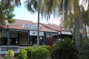
The building at 5 Napier Terrace was one of eight on Lot 12 in 1906, and was leased to Filipino diver Teofilo Storres, during which time the place may have been occupied as a boarding house for dive crew. Mrs Ilene McAlinden ran a boarding house in 1911-1912 and then it was leased to pearlers Oscar and Otto Blackman, trading as Blackman Brothers. Filipino diver Tedesforo Samante Ybasco (also known as Thomas Ibasco) bought 5 Napier Terrace in 1926 and ran a hairdressing business there for the next twenty years. Koepanger diver, Modo Bula (or Bolo), was the next owner and occupier. Bula had worked for the McDaniels since he was fourteen and Phyllis McDaniel claimed he was the best diver in Broome. By 1969, Modo Bula was employed as a Health Inspector and was living at Napier Terrace with his son. Chinese business proprietor, Yee Yeu Lwoy was the next owner (1973) and J. Matsumoto was the tenant. 'Castaways', a new and second-hand store dealing in household goods and camping equipment occupied the place in the 1980s. It was restored in 1989, purchased by Paul and Annelies Keller in 1991 and converted to a restaurant.
This information is provided voluntarily as a public service. The information provided is made available in good faith and is derived from sources believed to be reliable and accurate. However, the information is provided solely on the basis that readers will be responsible for making their own assessment of the matters discussed herein and are advised to verify all relevant representations, statements and information.
9 Napier Tce Broome
Cnr Carnarvon St Was 10-12 REGISTERED AS PART OF 291
Archie Martins
Broome
Kimberley
Constructed from 1900
| Type | Status | Date | Documents |
|---|---|---|---|
| (no listings) |
| Type | Status | Date | Documents |
|---|---|---|---|
| (no listings) |
| Type | Status | Date | Grading/Management | |
|---|---|---|---|---|
| Category | ||||
| (no listings) | ||||
00291 Chinatown Conservation Area
| Library Id | Title | Medium | Year Of Publication |
|---|---|---|---|
| 7550 | Kennedy Store Development Heritage Presentation. | C D Rom | 2003 |
| 9587 | Broome heritage trail. | Heritage Study {Other} | 1988 |
| 8335 | Historic buildings of the Kimberley region of W.A. | Book | 1988 |
Individual Building or Group
| Epoch | General | Specific |
|---|---|---|
| Original Use | COMMERCIAL | Shopping Complex |
| Present Use | COMMERCIAL | Shopping Complex |
| Style |
|---|
| Vernacular |
| Type | General | Specific |
|---|---|---|
| Wall | TIMBER | Other Timber |
| Roof | METAL | Corrugated Iron |
| General | Specific |
|---|---|
| OCCUPATIONS | Commercial & service industries |
| OCCUPATIONS | Fishing & other maritime industry |
This information is provided voluntarily as a public service. The information provided is made available in good faith and is derived from sources believed to be reliable and accurate. However, the information is provided solely on the basis that readers will be responsible for making their own assessment of the matters discussed herein and are advised to verify all relevant representations, statements and information.
Old Rd to Willie Creek Broome
Broome
Kimberley
| Type | Status | Date | Documents |
|---|---|---|---|
| (no listings) |
| Type | Status | Date | Documents |
|---|---|---|---|
| (no listings) |
| Type | Status | Date | Grading/Management | |
|---|---|---|---|---|
| Category | ||||
| Municipal Inventory | Adopted | 23 Oct 2003 | Criterion 3A | |
Historic site
| Epoch | General | Specific |
|---|---|---|
| Present Use | GOVERNMENTAL | Reservoir or Dam |
| Original Use | GOVERNMENTAL | Reservoir or Dam |
This information is provided voluntarily as a public service. The information provided is made available in good faith and is derived from sources believed to be reliable and accurate. However, the information is provided solely on the basis that readers will be responsible for making their own assessment of the matters discussed herein and are advised to verify all relevant representations, statements and information.
Afghan Wells are significant for their associations with camel transport.
Prior to the construction of serviceable roads, the Afghans and their pack camel teams provided an efficient and fast mode of transport across country in the north west, Kimberly and goldfields districts. There are a number of wells between Broome and Willie Creek, and around the Willie Creek area.
| Ref ID No | Ref Name | Ref Source | Ref Date |
|---|---|---|---|
| Maps of the Area | 1944 | ||
| Maps of the Area | 1967 |
This information is provided voluntarily as a public service. The information provided is made available in good faith and is derived from sources believed to be reliable and accurate. However, the information is provided solely on the basis that readers will be responsible for making their own assessment of the matters discussed herein and are advised to verify all relevant representations, statements and information.
Port Dr Broome
street frontage to Port Dr
Broome
Kimberley
Constructed from 1890
| Type | Status | Date | Documents |
|---|---|---|---|
| Heritage List | Adopted | 28 Aug 2014 | |
| State Register | Registered | 18 Nov 2008 | HCWebsite.Listing+ListingDocument, HCWebsite.Listing+ListingDocument |
| Type | Status | Date | Documents |
|---|---|---|---|
| (no listings) |
| Type | Status | Date | Grading/Management | |
|---|---|---|---|---|
| Category | ||||
| Municipal Inventory | Adopted | 28 Aug 2014 | Grading A | |
| Classified by the National Trust | Classified | 07 Jun 1983 | ||
| Register of the National Estate | Permanent | 18 Apr 1989 | ||
| Other Legal Agreement | Adopted | 02 Oct 2007 | ||
08781 Broome Cemetery
Generally, the Broome Cemetery is in fair to good condition. However, the Muslim cemetery is somewhat overgrown and has susatined some damage due to neglect. The Japanese cemetery has been subject to considerable vandalism resuting in damage to the headstones.
| Library Id | Title | Medium | Year Of Publication |
|---|---|---|---|
| 9600 | Broome: maps and places of heritage interest. | Heritage Study {Other} | 0 |
Other Built Type
| Epoch | General | Specific |
|---|---|---|
| Original Use | MONUMENT\CEMETERY | Cemetery |
| Present Use | MONUMENT\CEMETERY | Cemetery |
| Style |
|---|
| Other Style |
| Type | General | Specific |
|---|---|---|
| Other | OTHER | Other Material |
| General | Specific |
|---|---|
| SOCIAL & CIVIC ACTIVITIES | Cultural activities |
| SOCIAL & CIVIC ACTIVITIES | Religion |
| OCCUPATIONS | Fishing & other maritime industry |
| OUTSIDE INFLUENCES | Natural disasters |
| DEMOGRAPHIC SETTLEMENT & MOBILITY | Workers {incl. Aboriginal, convict} |
| DEMOGRAPHIC SETTLEMENT & MOBILITY | Immigration, emigration & refugees |
This information is provided voluntarily as a public service. The information provided is made available in good faith and is derived from sources believed to be reliable and accurate. However, the information is provided solely on the basis that readers will be responsible for making their own assessment of the matters discussed herein and are advised to verify all relevant representations, statements and information.
Constructed from 1906
08781 Broome Cemetery
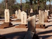
Broome Cemetery: Japanese, Chinese, Muslim sections are significant as a record of the non European pioneers and associations with Broome from c.1906 to present day, providing a unique record and history. The cemetery records the lives lost in the pearling industry and by other means. Many of the headstones are of aesthetic importance for their design characteristics that typify the specific nationalities. The Japanese cemetery is an integral part of the annual Japanese festivals of Lanterns for the dead (Bon Matsuri)
Three distinct sections at the rear of the main cemetery, each accessed separately. Low chain link perimeter fence. Entry statement in Chinese style signifies the Chinese Cemetery. The Japanese section has extensive headstone restorations in black stone, distinctive from the original headstones.
The Broome Cemetery was gazetted on 20 April 1890, as Reserve 1647, but Japanese, Chinese and Muslim burials were carried out on adjoining land, later designated as sections of the cemetery for each group. Japanese burials are marked by stone obelisks. Many of those buried in the Japanese cemetery came from Wakayama, in the southeast corner of the Island of Honshu. People from this region are famous for their abilities as fishermen and divers. Because most of the pearl divers in Broome were Japanese, their cemetery in particular bears testimony to the number of divers lost to the bends each year prior to the donation of a decompression chamber in 1913. On 15 August each year, the Japanese hold the Shinto festival ‘Obom’, to release the spirits of the departed on their journey. The Chinese hold the feast of Hung Ting, when food is offered to the spirits at an altar, Tai Puk Koong. Muslim Malays held joyful processions of remembrance headed by a decorated dragon, a tradition that has continued into the Shinju Matsuri Festival. Many of the obelisks in the Japanese cemetery have been renewed in recent years. The damaged headstones in the Japanese cemetery were replaced with new black granite headstones in the early 1980s. Restoration was made possible by funds donated by Ryoichi Sasakawa, chairman of the Japan Shipbuilding Industry Foundation, with the encouragement of Senator Kazuo Tamaki. The Chinese Cemetery has had a new entrance erected.
High degree Moderate degree
Mostly good. Japanese cemetery: Very good.
| Ref ID No | Ref Name | Ref Source | Ref Date |
|---|---|---|---|
| Burton, Val General History of Broome | Broome Historical Society | ||
| HCWA Register documentation |
| Ref Number | Description |
|---|---|
| No.24 | MI Place No. |
| Reserve | Lot/Location | Plan/Diagram | Vol/Folio |
|---|---|---|---|
| 1647 | 852 |
This information is provided voluntarily as a public service. The information provided is made available in good faith and is derived from sources believed to be reliable and accurate. However, the information is provided solely on the basis that readers will be responsible for making their own assessment of the matters discussed herein and are advised to verify all relevant representations, statements and information.
This section of the Broome Cemetery has particular significance to the Japanese community who have been association with Broome and pearling since the 1880’s. The Japanese pearling industry recently announced that it would fund and inventory and the restoration of early graves and shrines
Graves of Japanese are in a section of the main Broome cemetery on the western side of town, the numbers of graves bearing witness to the hundreds of lives lost in the pearling industry. The rough hewn headstones inscribed in Japanese are piled with food each year for the Bon Matsuri – the feast of lanterns for the dead – and lanterns are lit amongst them.
Assessment 1983
This information is provided voluntarily as a public service. The information provided is made available in good faith and is derived from sources believed to be reliable and accurate. However, the information is provided solely on the basis that readers will be responsible for making their own assessment of the matters discussed herein and are advised to verify all relevant representations, statements and information.
Port Dr Broome
Broome
Kimberley
| Type | Status | Date | Documents |
|---|---|---|---|
| (no listings) |
| Type | Status | Date | Documents |
|---|---|---|---|
| (no listings) |
| Type | Status | Date | Grading/Management | |
|---|---|---|---|---|
| Category | ||||
| Municipal Inventory | Adopted | 28 Aug 2014 | Grading C | |
Other Built Type
| Epoch | General | Specific |
|---|---|---|
| Present Use | OTHER | Other |
| Original Use | OTHER | Other |
| Type | General | Specific |
|---|---|---|
| Other | CONCRETE | Other Concrete |
This information is provided voluntarily as a public service. The information provided is made available in good faith and is derived from sources believed to be reliable and accurate. However, the information is provided solely on the basis that readers will be responsible for making their own assessment of the matters discussed herein and are advised to verify all relevant representations, statements and information.
Constructed from 1966
Broome's deep-water port and jetty is significant for the associations with shipping, and imports and exports, and more recently tourism.
The deep-water jetty is 2,292 feet (700 metres) long. It is a steel and concrete construction with a reinforced concrete deck cast over composite steel beams supported on steel girders which are in turn supported on hollow tubular steel piles
The deep-water jetty is 2,292 feet (700 metres) long. It is a steel and concrete construction with a reinforced concrete deck cast over composite steel beams supported on steel girders which are in turn supported on hollow tubular steel piles. Broome’s deep water port and jetty were opened in 1966 by the Premier Sir David Brand. It cost over $3 million. Cyclone Rosita in 2000 damaged the jetty. After that the Port offices at the end of the jetty were relocated to a new facility at the shore end of the jetty.
High degree High degree
Good
| Ref Number | Description |
|---|---|
| No.46 | MI Place No. |
| Reserve | Lot/Location | Plan/Diagram | Vol/Folio |
|---|---|---|---|
| 28650 |
This information is provided voluntarily as a public service. The information provided is made available in good faith and is derived from sources believed to be reliable and accurate. However, the information is provided solely on the basis that readers will be responsible for making their own assessment of the matters discussed herein and are advised to verify all relevant representations, statements and information.
Port Dr Broome
Broome
Kimberley
Constructed from 1964
| Type | Status | Date | Documents |
|---|---|---|---|
| (no listings) |
| Type | Status | Date | Documents |
|---|---|---|---|
| (no listings) |
| Type | Status | Date | Grading/Management | |
|---|---|---|---|---|
| Category | ||||
| Municipal Inventory | Adopted | 28 Aug 2014 | Grading C | |
Individual Building or Group
| Epoch | General | Specific |
|---|---|---|
| Original Use | Transport\Communications | Water: Dock\Wharf Bldg or Structure |
| Present Use | Transport\Communications | Water: Dock\Wharf Bldg or Structure |
| General | Specific |
|---|---|
| TRANSPORT & COMMUNICATIONS | River & sea transport |
| OUTSIDE INFLUENCES | Water, power, major t'port routes |
This information is provided voluntarily as a public service. The information provided is made available in good faith and is derived from sources believed to be reliable and accurate. However, the information is provided solely on the basis that readers will be responsible for making their own assessment of the matters discussed herein and are advised to verify all relevant representations, statements and information.
Constructed from 1966
26196 BROOME JETTY/PORT OF BROOME
Broome's deep-water port and jetty is significant for the associations with shipping, and imports and exports, and more recently tourism.
The deep-water jetty is 2,292 feet (700 metres) long. It is a steel and concrete construction with a reinforced concrete deck cast over composite steel beams supported on steel girders which are in turn supported on hollow tubular steel piles.
The deep-water jetty is 2,292 feet (700 metres) long. It is a steel and concrete construction with a reinforced concrete deck cast over composite steel beams supported on steel girders which are in turn supported on hollow tubular steel piles. Broome’s deep water port and jetty were opened in 1966 by the Premier Sir David Brand. It cost over $3 million. Cyclone Rosita in 2000 damaged the jetty. After that the Port offices at the end of the jetty were relocated to a new facility at the shore end of the jetty.
INTEGRITY High degree AUTHENTICITY High degree
Good
| Reserve | Lot/Location | Plan/Diagram | Vol/Folio |
|---|---|---|---|
| 28650 |
This information is provided voluntarily as a public service. The information provided is made available in good faith and is derived from sources believed to be reliable and accurate. However, the information is provided solely on the basis that readers will be responsible for making their own assessment of the matters discussed herein and are advised to verify all relevant representations, statements and information.
102 Port Dr Broome
NE cnr Guy St
Broome
Kimberley
Constructed from 1985
| Type | Status | Date | Documents |
|---|---|---|---|
| (no listings) |
| Type | Status | Date | Documents |
|---|---|---|---|
| (no listings) |
| Type | Status | Date | Grading/Management | |
|---|---|---|---|---|
| Category | ||||
| Municipal Inventory | Adopted | 28 Aug 2014 | Grading C | |
| Name | Type | Year From | Year To |
|---|---|---|---|
| William Fitzhardinge | Architect | - | - |
Individual Building or Group
| Epoch | General | Specific |
|---|---|---|
| Original Use | RELIGIOUS | Church, Cathedral or Chapel |
| Present Use | RELIGIOUS | Church, Cathedral or Chapel |
| Style |
|---|
| Other Style |
| General | Specific |
|---|---|
| SOCIAL & CIVIC ACTIVITIES | Religion |
This information is provided voluntarily as a public service. The information provided is made available in good faith and is derived from sources believed to be reliable and accurate. However, the information is provided solely on the basis that readers will be responsible for making their own assessment of the matters discussed herein and are advised to verify all relevant representations, statements and information.
Constructed from 1985
St Mary's College Chapel is significant for its distinctive architecture and associations with St Mary’s School.
The building is striking in its contrast to other Broome buildings. The form is pyramidal with a low-pitched gable roof on top. The steel framed building, with elements of the splayed structure exposed, is situation on a stone-retained rise in an otherwise flat site. It is clad with vertical format sheeting, and the windows feature amber glass fixed sections along the base. The interior is stepped down stadium style and the walls are face stone in the altar area.
In 1908, St Mary's Catholic School was begun by the Sisters of St John of God, with classes held in the church. The first school building was opened in 1911. The students were Australians, Europeans, Japanese, Chinese, Malays and Filipinos. Aboriginal children could not attend initially, as Aboriginal people were not permitted within the town at this time. In 1973, there were 215 children enrolled at St Mary's Primary School. Since 1976, the Loreto Sisters have taught at the school. Nulungu College for Aboriginal students opened in 1971, staffed by Christian Brothers and Our Lady of the Mission Sisters. Many of the Catholic Church buildings at Broome have been designed by architect William Fitzhardinge.
High degree High degree
Good
| Ref ID No | Ref Name | Ref Source | Ref Date |
|---|---|---|---|
| University of Notre Dame University Press | 1994 | ||
| A history of the Catholic Church in the Kimberley | 1884-1984 | ||
| Margaret Zucker | From Patrons to Partners |
| Ref Number | Description |
|---|---|
| No.25 | MI Place No. |
| Reserve | Lot/Location | Plan/Diagram | Vol/Folio |
|---|---|---|---|
| 130547 | 949 |
This information is provided voluntarily as a public service. The information provided is made available in good faith and is derived from sources believed to be reliable and accurate. However, the information is provided solely on the basis that readers will be responsible for making their own assessment of the matters discussed herein and are advised to verify all relevant representations, statements and information.
401 Port Dv Broome
Broome
Kimberley
Constructed from 1966
| Type | Status | Date | Documents |
|---|---|---|---|
| (no listings) |
| Type | Status | Date | Documents |
|---|---|---|---|
| (no listings) |
| Type | Status | Date | Grading/Management | |
|---|---|---|---|---|
| Category | ||||
| Municipal Inventory | Adopted | 28 Aug 2014 | Grading C | |
06720 Port of Broome
Historic site
| Epoch | General | Specific |
|---|---|---|
| Original Use | Transport\Communications | Water: Jetty |
| Present Use | Transport\Communications | Water: Jetty |
| Type | General | Specific |
|---|---|---|
| Other | TIMBER | Other Timber |
| Other | METAL | Steel |
| General | Specific |
|---|---|
| TRANSPORT & COMMUNICATIONS | River & sea transport |
This information is provided voluntarily as a public service. The information provided is made available in good faith and is derived from sources believed to be reliable and accurate. However, the information is provided solely on the basis that readers will be responsible for making their own assessment of the matters discussed herein and are advised to verify all relevant representations, statements and information.
Constructed from 1966
26196 BROOME JETTY/PORT OF BROOME
Broome's deep-water port and jetty is significant for the associations with shipping, and imports and exports, and more recently tourism.
The deep-water jetty is 2,292 feet (700 metres) long. It is a steel and concrete construction with a reinforced concrete deck cast over composite steel beams supported on steel girders which are in turn supported on hollow tubular steel piles.
The deep-water jetty is 2,292 feet (700 metres) long. It is a steel and concrete construction with a reinforced concrete deck cast over composite steel beams supported on steel girders which are in turn supported on hollow tubular steel piles. Broome’s deep water port and jetty were opened in 1966 by the Premier Sir David Brand. It cost over $3 million. Cyclone Rosita in 2000 damaged the jetty. After that the Port offices at the end of the jetty were relocated to a new facility at the shore end of the jetty.
INTEGRITY High degree AUTHENTICITY High degree Modifications: As required to remain functional to all required standards of a working port.
Good
| Ref ID No | Ref Name | Ref Source | Ref Date |
|---|---|---|---|
| Shire of Broome's Municipal Inventory. | 1996 |
| Reserve | Lot/Location | Plan/Diagram | Vol/Folio |
|---|---|---|---|
| 28650 |
This information is provided voluntarily as a public service. The information provided is made available in good faith and is derived from sources believed to be reliable and accurate. However, the information is provided solely on the basis that readers will be responsible for making their own assessment of the matters discussed herein and are advised to verify all relevant representations, statements and information.
Robinson St Broome
Broome
Kimberley
| Type | Status | Date | Documents |
|---|---|---|---|
| (no listings) |
| Type | Status | Date | Documents |
|---|---|---|---|
| (no listings) |
| Type | Status | Date | Grading/Management | |
|---|---|---|---|---|
| Category | ||||
| Municipal Inventory | Adopted | 28 Aug 2014 | Grading B | |
Other Built Type
| Epoch | General | Specific |
|---|---|---|
| Present Use | SOCIAL\RECREATIONAL | Other |
| Original Use | SOCIAL\RECREATIONAL | Other |
This information is provided voluntarily as a public service. The information provided is made available in good faith and is derived from sources believed to be reliable and accurate. However, the information is provided solely on the basis that readers will be responsible for making their own assessment of the matters discussed herein and are advised to verify all relevant representations, statements and information.
Constructed from 1897
Town Beach is significant as a place of social gathering and recreation for residents and visitors of Broome. The remains of Town Jetty is an important historical site representing the shipping and pearling industries that were the foundation and sustenance of settlement and development in Broome.
Town Beach area comprises a grassed area down to shoreline of pristine sandy bay with remains of Town Jetty to the northeast. The jetty remains is an embankment of stone backfill at the northeast end of Town Beach- extending out from the Pioneer Cemetery promontory, and at the south end of Roebuck Bay. Carpark, ablution facilities, playground, water playground and café provide amenities. There are several commemorative plaques placed at random within the grassed area along the shoreline.
Mangrove Point Jetty was constructed in 1897 as the Town jetty. It was 2,953 feet (900 metres) long and 15 feet (4.5 metres) wide, with a 'T'-shaped head 340 feet (103 metres) long and 30 feet (9 metres) wide. Contract for the structure was for £17,519. The jetty was connected to the town and to Streeter's Jetty in Chinatown, by a tramway. The line ran down the centre of the jetty and on one side was a cattle race, a box-like structure enclosed on both sides. Cattle were driven along the race to be loaded onto a waiting ship. The jetty was important for the transport of stock because of the considerable overland distance. Despite its length, boats were still left stranded at low tide. The jetty was the place to be seen when the steamships were in: master pearlers in white suits with two gold studs at the neck band and wearing pith helmets and the ladies with parasols. The steamship lounges would be open for the enjoyment of gin slings and whiskey and sodas. The jetty closed in the late 1960s, when a new deepwater port jetty was built further south. Mangrove Point remains a tourist lookout, viewing site and popular fishing spot.
Moderate degree Moderate degree
Good
| Ref ID No | Ref Name | Ref Source | Ref Date |
|---|---|---|---|
| Broome Historical Society |
| Ref Number | Description |
|---|---|
| No.33 | MI Place No. |
| Reserve | Lot/Location | Plan/Diagram | Vol/Folio |
|---|---|---|---|
| 600 |
This information is provided voluntarily as a public service. The information provided is made available in good faith and is derived from sources believed to be reliable and accurate. However, the information is provided solely on the basis that readers will be responsible for making their own assessment of the matters discussed herein and are advised to verify all relevant representations, statements and information.
24 Robinson St Broome
was 31
Durack Gallery; General Store
Golden Shower Dress Shop
Broome
Kimberley
Constructed from 1920
| Type | Status | Date | Documents |
|---|---|---|---|
| (no listings) |
| Type | Status | Date | Documents |
|---|---|---|---|
| RHP - Does not warrant assessment | Current | 11 Jul 2003 |
| Type | Status | Date | Grading/Management | |
|---|---|---|---|---|
| Category | ||||
| Municipal Inventory | Adopted | 28 Aug 2014 | Grading C | |
Individual Building or Group
| Epoch | General | Specific |
|---|---|---|
| Present Use | COMMERCIAL | Other |
| Original Use | COMMERCIAL | Shop\Retail Store {single} |
| Type | General | Specific |
|---|---|---|
| Wall | TIMBER | Other Timber |
| Roof | METAL | Corrugated Iron |
| General | Specific |
|---|---|
| OCCUPATIONS | Commercial & service industries |
This information is provided voluntarily as a public service. The information provided is made available in good faith and is derived from sources believed to be reliable and accurate. However, the information is provided solely on the basis that readers will be responsible for making their own assessment of the matters discussed herein and are advised to verify all relevant representations, statements and information.
Constructed from 1920
Store (fmr) is a good representative example of a typical early commercial/dwelling with few subsequent alterations.
A single storey timber framed structure with horizontal corrugated iron wall cladding. The hipped roof is also clad with corrugated iron. Front verandah under main roof.
Lot 502 was a general store for many years before it was a dress shop in the 1970s, a gallery in the 1990s, a residence at various times.
High degree Moderate degree
Fair
| Ref Number | Description |
|---|---|
| No.26 | MI Place No. |
| Reserve | Lot/Location | Plan/Diagram | Vol/Folio |
|---|---|---|---|
| 502 |
This information is provided voluntarily as a public service. The information provided is made available in good faith and is derived from sources believed to be reliable and accurate. However, the information is provided solely on the basis that readers will be responsible for making their own assessment of the matters discussed herein and are advised to verify all relevant representations, statements and information.
40 Robinson St Broome
Broome
Kimberley
Constructed from 1900
| Type | Status | Date | Documents |
|---|---|---|---|
| Heritage List | Adopted | 28 Aug 2014 |
| Type | Status | Date | Documents |
|---|---|---|---|
| (no listings) |
| Type | Status | Date | Grading/Management | |
|---|---|---|---|---|
| Category | ||||
| Municipal Inventory | Adopted | 28 Aug 2014 | Grading B | |
Individual Building or Group
| Epoch | General | Specific |
|---|---|---|
| Present Use | RESIDENTIAL | Single storey residence |
| Original Use | RESIDENTIAL | Single storey residence |
| Style |
|---|
| Federation Bungalow |
| Type | General | Specific |
|---|---|---|
| Wall | METAL | Corrugated Iron |
| Roof | METAL | Corrugated Iron |
| General | Specific |
|---|---|
| OCCUPATIONS | Fishing & other maritime industry |
This information is provided voluntarily as a public service. The information provided is made available in good faith and is derived from sources believed to be reliable and accurate. However, the information is provided solely on the basis that readers will be responsible for making their own assessment of the matters discussed herein and are advised to verify all relevant representations, statements and information.
Constructed from 1900
T. McDaniel’s Residence (former) is significant for the long association with one of Broome’s pearling pioneer families. It is typical of an early 1900s dwelling with few subsequent alterations.
Single storey timber framed structure with horizontal corrugated iron wall cladding. The hipped roof is also clad with corrugated iron. Verandah under main roof is enclosed by hinged shutters above dado. Originally a two roomed cottage it has been extended and developed. Recently restored. Some renovations.
Terence McDaniel was the son of pearlers Daniel and Phyllis McDaniel. Terence and his brother Nolan worked in the family's pearling business. Terence McDaniel served in World War Two as a pilot in the RAAF, surviving two crashes. He married twice and had three daughters from his first marriage. He was a member of the Road Board and Shire Council from 1950-1964. On 11 September 1965, Terence received a phone call at 2.30am, warning that a jail escapee had been seen near his pearling lugger. While getting ready to investigate the report, he accidentally shot himself in the back as he was strapping his revolver around his waist. He was taken to Derby hospital where he died four days later. He was accorded a guard of honour of RSL members at his burial in the Pioneer Cemetery.
High degree Moderate degree
Good
| Ref ID No | Ref Name | Ref Source | Ref Date |
|---|---|---|---|
| OH212 | Oral History of Phyllis Everett McDaniel | Battye Library | |
| Western Australian Cemetaries Index |
| Ref Number | Description |
|---|---|
| No.27 | MI Place No. |
| Reserve | Lot/Location | Plan/Diagram | Vol/Folio |
|---|---|---|---|
| 200 |
This information is provided voluntarily as a public service. The information provided is made available in good faith and is derived from sources believed to be reliable and accurate. However, the information is provided solely on the basis that readers will be responsible for making their own assessment of the matters discussed herein and are advised to verify all relevant representations, statements and information.
59 Robinson St Broome
Cordial Cool Drink Factory, Topsy's Cafe
Wine & Spirit Merchants, Ice Works
Broome
Kimberley
Constructed from 1975
| Type | Status | Date | Documents |
|---|---|---|---|
| (no listings) |
| Type | Status | Date | Documents |
|---|---|---|---|
| (no listings) |
| Type | Status | Date | Grading/Management | |
|---|---|---|---|---|
| Category | ||||
| Municipal Inventory | Adopted | 28 Aug 2014 | Grading C | |
Other Built Type
| Epoch | General | Specific |
|---|---|---|
| Original Use | COMMERCIAL | Shop\Retail Store {single} |
| Present Use | COMMERCIAL | Shop\Retail Store {single} |
| Style |
|---|
| Other Style |
| Type | General | Specific |
|---|---|---|
| Wall | RENDER | Other Render |
| General | Specific |
|---|---|
| SOCIAL & CIVIC ACTIVITIES | Community services & utilities |
This information is provided voluntarily as a public service. The information provided is made available in good faith and is derived from sources believed to be reliable and accurate. However, the information is provided solely on the basis that readers will be responsible for making their own assessment of the matters discussed herein and are advised to verify all relevant representations, statements and information.
Seaview Shopping Centre site is significant in recognition as a community-meeting place, with the community notice board that provided a focal point for the local community, and it distinctive architecture complemented the multicultural ethos of Broome in the first shopping centre in the town.
Supermarket and cafe on part of the site.
The site has been occupied by various business over its history: James and Piggott Wine and Spirit Merchants, Ice works and cordial cool drink factory, and Topsy’s Café (1960s). Broome households used ice boxes to keep food cold before the advent of kerosene refrigerators and AC power. There were several ice works in town that manufactured ice, and James and Piggott ran one on this site. Supplies arrived by ship and the ice works had cool rooms where butter and other perishable foods were kept. The site was adjacent to the tram line between the jetty and Chinatown. Seaview Shopping centre was opened in the early 1980s. It was the first shopping centre constructed in Broome with a variety of shops less than one roof. It later had the distinction of being labelled the ‘most expensive shopping centre in Australia’ by Choice magazine. After 2004 the Seaview Shopping Centre was demolished and the site has been partially redeveloped.
| Ref Number | Description |
|---|---|
| No.31 | MI Place No. |
| Reserve | Lot/Location | Plan/Diagram | Vol/Folio |
|---|---|---|---|
| 268 |
This information is provided voluntarily as a public service. The information provided is made available in good faith and is derived from sources believed to be reliable and accurate. However, the information is provided solely on the basis that readers will be responsible for making their own assessment of the matters discussed herein and are advised to verify all relevant representations, statements and information.

67 Robinson St Broome
Broome Historical Society Museum
Customs House (fmr)
Queen's Warehouse
Broome
Kimberley
Constructed from 1889
| Type | Status | Date | Documents |
|---|---|---|---|
| Heritage List | Adopted | 28 Aug 2014 | |
| Consent Order | YES | 24 Feb 2017 | |
| State Register | Removed | 21 Feb 2017 | HCWebsite.Listing+ListingDocument |
| Type | Status | Date | Documents |
|---|---|---|---|
| (no listings) |
| Type | Status | Date | Grading/Management | |
|---|---|---|---|---|
| Category | ||||
| Municipal Inventory | Adopted | 28 Aug 2014 | Grading A | |
| Classified by the National Trust | Classified | 07 Jun 1983 | ||
| Register of the National Estate | Permanent | 18 Apr 1989 | ||
27015 Customs House and Sub-Collector's Residence, Broome
Broome Museum precinct comprises the museum and adjacent site of the goods shed and tram tracks. The museum is a single storey concrete, hipped roof pavilion with surrounding verandahs that have subsequently been enclosed. The bay frontage (store entry) has a vented gablet. There are concrete footings showing evidence of the goods shed.
A single storey building with formed concrete walls & timber framed corrugated iron clad roof. Built c 1890 as the Queen's Warehouse & subsequently used by customs, the building has recently been converted for use as a museum for the local history society.
| Name | Type | Year From | Year To |
|---|---|---|---|
| Government of W.A. | Architect | - | - |
| Library Id | Title | Medium | Year Of Publication |
|---|---|---|---|
| 9486 | Broome museum (museum building and sailmaker's shed) conservation management plan. | Heritage Study {Cons'n Plan} | 2009 |
| 8335 | Historic buildings of the Kimberley region of W.A. | Book | 1988 |
| 9600 | Broome: maps and places of heritage interest. | Heritage Study {Other} | 0 |
Individual Building or Group
| Epoch | General | Specific |
|---|---|---|
| Present Use | EDUCATIONAL | Museum |
| Other Use | GOVERNMENTAL | Customs House\Bond Store |
| Original Use | COMMERCIAL | Warehouse |
| Style |
|---|
| Victorian Georgian |
| Type | General | Specific |
|---|---|---|
| Roof | METAL | Corrugated Iron |
| Wall | CONCRETE | Other Concrete |
| General | Specific |
|---|---|
| OCCUPATIONS | Fishing & other maritime industry |
| SOCIAL & CIVIC ACTIVITIES | Institutions |
This information is provided voluntarily as a public service. The information provided is made available in good faith and is derived from sources believed to be reliable and accurate. However, the information is provided solely on the basis that readers will be responsible for making their own assessment of the matters discussed herein and are advised to verify all relevant representations, statements and information.
Constructed from 1889, Constructed from 1904
27015 Customs House and Sub-Collector's Residence, Broome
Broome Museum is of considerable significance for the associations with the bond store, customs house and the movement of goods in and out of Broome from 1890. Broome Museum is important for its role of conserving and promoting Broome’s heritage and history. The precinct is significant for the associations with customs and the tram system linked to the jetty (site now) at Mangrove Point, Customs House and Chinatown. The design aesthetic and concrete construction materials of the Customs building are significant for demonstrating a local vernacular response to the tropical climate. Sailmaker’s shed (former) is of considerable significance for associations with the pearling industry by means of repairing and making sails for the pearl lugger fleet.
Broome Museum group comprises the original Customs House and Sailmaker’s shed, located in close proximity to the adjacent site of the goods shed and tram tracks. The Customs House is a single storey concrete structure, hipped roof pavilion with surrounding verandahs that have subsequently been enclosed. The bay frontage (store entry) has a vented gablet. Sailmaker’s shed (former) is a single storey steel framed shed clad with horizontal corrugated iron. Gabled roof, ledge and brace doors. The words ‘C. BAGGE sailmaker’ are still discernable on the end wall facing Roebuck Bay. It was extensively restored in 2010/11/12. There are concrete footings showing evidence of the goods shed and railway siding on the adjacent site. The former CWA building has been relocated into the Museum area but does not form part of this listing.
The Government Bond store was built in 1889, and was known as the Queen's Bond store, and then the King's Bond store after the death of Queen Victoria in 1901. The Bond store later became the Customs House. The building was a concrete construction built to withstand cyclones. The tramway that ran between Streeter's and Mangrove Point jetties ran past the Customs House on the eastern foreshore side. The arrival of pearling crews at the start of their contracts, and their departure at the end, was a noisy, colourful affair. The men piled into the trucks and carriages of the tram and were taken to the Customs House, where they were signed in, or off, to their respective pearling masters amid much chaos as most of the men spoke little if any English. Between the Customs House and the jetty was a concrete building used to fumigate crews' belongings (presumably only on their way in). Also beside the tramway near the Customs House was the Fisheries Inspector's Office and a large goods shed. Pearling boat movements in and out of Roebuck Bay were monitored from the Fisheries Office while the goods shed was the collection point for goods brought in by boat and goods waiting to be shipped out. The tramway ceased operation in 1948 and in 1970, a fire destroyed the goods shed. In 1981, the Customs House was vested in the Shire of Broome and opened as the Broome Historical Museum by Premier Sir Charles Court. The Historical Museum is run by the Broome Historical Society.
INTEGRITY High degree AUTHENTICITY High degree Modifications: Minimal alterations to accommodate various uses.
Good
| Ref ID No | Ref Name | Ref Source | Ref Date |
|---|---|---|---|
| Broome Historical Society;"Information provided by Kim Male". | |||
| T Chapple;"Broome, The Exciting Years 1912-1930". | |||
| Shire of Broome's Municipal Inventory. | 1996 |
| Owner | Category |
|---|---|
| Shire of Broome | Local Gov't |
This information is provided voluntarily as a public service. The information provided is made available in good faith and is derived from sources believed to be reliable and accurate. However, the information is provided solely on the basis that readers will be responsible for making their own assessment of the matters discussed herein and are advised to verify all relevant representations, statements and information.
An interesting example of the development of the Broome house form into larger public buildings. The early use of in-situ concrete is also significant
A single storeyed building with formed concrete walls and a timber framed corrugated iron clad roof. Built circa 1890 as the Queen's Warehouse and subsequently used by Customs, the building has recently been converted for use as a museum for the local Historical Society.
Assessment 1982 Construction c.1889
This information is provided voluntarily as a public service. The information provided is made available in good faith and is derived from sources believed to be reliable and accurate. However, the information is provided solely on the basis that readers will be responsible for making their own assessment of the matters discussed herein and are advised to verify all relevant representations, statements and information.
67/69/71 Robinson St Broome
Broome
Kimberley
| Type | Status | Date | Documents |
|---|---|---|---|
| Heritage List | Adopted | 28 Aug 2014 |
| Type | Status | Date | Documents |
|---|---|---|---|
| (no listings) |
| Type | Status | Date | Grading/Management | |
|---|---|---|---|---|
| Category | ||||
| Municipal Inventory | Adopted | 28 Aug 2014 | Grading A | |
Other Built Type
| Epoch | General | Specific |
|---|---|---|
| Original Use | GOVERNMENTAL | Customs House\Bond Store |
| Other Use | OTHER | Other |
| Present Use | EDUCATIONAL | Museum |
| Style |
|---|
| Federation Bungalow |
| Type | General | Specific |
|---|---|---|
| Roof | OTHER | Other Material |
| Wall | CONCRETE | Concrete Block |
This information is provided voluntarily as a public service. The information provided is made available in good faith and is derived from sources believed to be reliable and accurate. However, the information is provided solely on the basis that readers will be responsible for making their own assessment of the matters discussed herein and are advised to verify all relevant representations, statements and information.
Constructed from 1889, Constructed from 1904
Broome Museum is of considerable significance for the associations with the bond store, customs house and the movement of goods in and out of Broome from 1890. Broome Museum is important for its role of conserving and promoting Broome’s heritage and history. The precinct is significant for the associations with customs and the tram system linked to the jetty (site now) at Mangrove Point, Customs House and Chinatown. The design aesthetic and concrete construction materials of the Customs building are significant for demonstrating a local vernacular response to the tropical climate. Sailmaker’s shed (former) is of considerable significance for associations with the pearling industry by means of repairing and making sails for the pearl lugger fleet.
Broome Museum group comprises the original Customs House and Sailmaker’s shed, located in close proximity to the adjacent site of the goods shed and tram tracks. The Customs House is a single storey concrete structure, hipped roof pavilion with surrounding verandahs that have subsequently been enclosed. The bay frontage (store entry) has a vented gablet. Sailmaker’s shed (former) is a single storey steel framed shed clad with horizontal corrugated iron. Gabled roof, ledge and brace doors. The words ‘C. BAGGE sailmaker’ are still discernable on the end wall facing Roebuck Bay. It was extensively restored in 2010/11/12. There are concrete footings showing evidence of the goods shed and railway siding on the adjacent site. The former CWA building has been relocated into the Museum area but does not form part of this listing.
The Government Bond store was built in 1889, and was known as the Queen's Bond store, and then the King's Bond store after the death of Queen Victoria in 1901. The Bond store later became the Customs House. The building was a concrete construction built to withstand cyclones. The tramway that ran between Streeter's and Mangrove Point jetties ran past the Customs House on the eastern foreshore side. The arrival of pearling crews at the start of their contracts, and their departure at the end, was a noisy, colourful affair. The men piled into the trucks and carriages of the tram and were taken to the Customs House, where they were signed in, or off, to their respective pearling masters amid much chaos as most of the men spoke little if any English. Between the Customs House and the jetty was a concrete building used to fumigate crews' belongings (presumably only on their way in). Also beside the tramway near the Customs House was the Fisheries Inspector's Office and a large goods shed. Pearling boat movements in and out of Roebuck Bay were monitored from the Fisheries Office while the goods shed was the collection point for goods brought in by boat and goods waiting to be shipped out. The tramway ceased operation in 1948 and in 1970, a fire destroyed the goods shed. In 1981, the Customs House was vested in the Shire of Broome and opened as the Broome Historical Museum by Premier Sir Charles Court. The Historical Museum is run by the Broome Historical Society.
High degree High degree
Good
| Ref ID No | Ref Name | Ref Source | Ref Date |
|---|---|---|---|
| Conservation Management Plan L Gray & I Sauman | Broome Museum | 2009 | |
| Tom Chapple, Broome | The Exciting Years | 1912-1930 | |
| information provided by Kim Male | Broome Historical Society |
| Ref Number | Description |
|---|---|
| No.30 | MI Place No. |
| Reserve | Lot/Location | Plan/Diagram | Vol/Folio |
|---|---|---|---|
| 4/3/240 |
This information is provided voluntarily as a public service. The information provided is made available in good faith and is derived from sources believed to be reliable and accurate. However, the information is provided solely on the basis that readers will be responsible for making their own assessment of the matters discussed herein and are advised to verify all relevant representations, statements and information.