Local Government
Fremantle
Region
Metropolitan
210 Queen Victoria St North Fremantle
Fremantle
Metropolitan
| Type | Status | Date | Documents |
|---|---|---|---|
| (no listings) |
| Type | Status | Date | Documents |
|---|---|---|---|
| (no listings) |
| Type | Status | Date | Grading/Management | |
|---|---|---|---|---|
| Category | ||||
| Municipal Inventory | Adopted | 14 Dec 2016 | Historical Record Only | |
Historic Site
| Epoch | General | Specific |
|---|---|---|
| Original Use | RESIDENTIAL | Other |
This information is provided voluntarily as a public service. The information provided is made available in good faith and is derived from sources believed to be reliable and accurate. However, the information is provided solely on the basis that readers will be responsible for making their own assessment of the matters discussed herein and are advised to verify all relevant representations, statements and information.
Constructed from 1932
DEMOLISHED. Retained on MHI for historical information only.
Queen Victoria Street developed from the 1860s following the construction of the North Fremantle Traffic Bridge and the upgrading of Perth Road by convicts. Initially called Perth Road, the street has had a number of names over the years: Victoria Avenue (c.1907-c. 1937), Stirling Highway (c. 1937 to c. 1976) and Queen Victoria Street (c. 1976 on). The area bounded by Queen Victoria Street, Stirling Highway (previously Bruce Street) and John Street was the commercial and social centre of North Fremantle, where public buildings such as the town hall, police station and post office were located. Also in this vicinity were the pubs and wine bars, butchers, bakers, grocers, haberdashery and barbers shops that catered for the needs of the local community. Queen Victoria Street continues to be North Fremantle’s main commercial precinct in North Fremantle. A brick house of five rooms was constructed at 10 Victoria Road in 1932-33 for Mr Williams.
| Ref ID No | Ref Name | Ref Source | Ref Date |
|---|---|---|---|
| MI not adopted - |
This information is provided voluntarily as a public service. The information provided is made available in good faith and is derived from sources believed to be reliable and accurate. However, the information is provided solely on the basis that readers will be responsible for making their own assessment of the matters discussed herein and are advised to verify all relevant representations, statements and information.
211-217 Queen Victoria St North Fremantle
Police Station & Lock-up
Fremantle
Metropolitan
Constructed from 1898
| Type | Status | Date | Documents |
|---|---|---|---|
| Heritage List | YES | 08 Mar 2007 | |
| Heritage Agreement | YES | 20 Dec 2016 | HCWebsite.Listing+ListingDocument |
| State Register | Registered | 28 Feb 1995 | HCWebsite.Listing+ListingDocument, HCWebsite.Listing+ListingDocument |
| Type | Status | Date | Documents |
|---|---|---|---|
| (no listings) |
| Type | Status | Date | Grading/Management | |
|---|---|---|---|---|
| Category | ||||
| Municipal Inventory | Adopted | 18 Sep 2000 | Level 1A | |
| Register of the National Estate | Permanent | 21 Mar 1978 | ||
| Classified by the National Trust | Classified | 01 Apr 1974 | ||
03794 North Fremantle Town Centre Precinct
| Name | Type | Year From | Year To |
|---|---|---|---|
| design attributed to Hardwick under direction of J. H. Grainger (Chief Architect). | Architect | - | - |
| drawn by W. H. Illingworth (PWD), examined by W. B. Hardwick. | Architect | - | - |
| Library Id | Title | Medium | Year Of Publication |
|---|---|---|---|
| 9988 | Provisional conservation policy for the former North Fremantle Police Station (currently North Fremantle Post Office snd Homeswest Houses) | Heritage Study {Cons'n Plan} | 1993 |
| 11506 | North Fremantle Post Office (Former Police Station, Lockup and Quarters) 211 - 217 Queen Victoria Street North Fremantle | Heritage Study {Cons'n Plan} | 2013 |
| 1679 | North Fremantle post office and police station | Heritage Study {Other} | 1991 |
Individual Building or Group
| Epoch | General | Specific |
|---|---|---|
| Original Use | GOVERNMENTAL | Police Station or Quarters |
| Other Use | Transport\Communications | Comms: Post or Telegraph Office |
| Present Use | COMMERCIAL | Office or Administration Bldg |
| Style |
|---|
| Victorian Georgian |
| Type | General | Specific |
|---|---|---|
| Wall | STONE | Limestone |
| Roof | METAL | Corrugated Iron |
| General | Specific |
|---|---|
| DEMOGRAPHIC SETTLEMENT & MOBILITY | Government policy |
| SOCIAL & CIVIC ACTIVITIES | Law & order |
| DEMOGRAPHIC SETTLEMENT & MOBILITY | Land allocation & subdivision |
| TRANSPORT & COMMUNICATIONS | Mail services |
| TRANSPORT & COMMUNICATIONS | Telecommunications |
This information is provided voluntarily as a public service. The information provided is made available in good faith and is derived from sources believed to be reliable and accurate. However, the information is provided solely on the basis that readers will be responsible for making their own assessment of the matters discussed herein and are advised to verify all relevant representations, statements and information.
Constructed from 1898
HCWA Register of Heritage Places-Permanent Entry North Fremantle Post Office North Fremantle Post Office has cultural heritage significance for the following reasons: the place has a landmark quality in the streetscape by virtue of its location at the corner of a busy intersection and through its strong three dimensional form; the place is one of a few remaining buildings in what was once a coherent streetscape in North Fremantle. Its loss would seriously diminish the interpretation of the historical and architectural development of North Fremantle; the place is held in high regard by the community and has a high degree of social importance because of its role in relation to the police force for over seventy years, and the post office for over twenty-four years; the place has a symbolic meaning as a surviving remnant of the former North Fremantle townsite and is highly significant in contributing to the community's sense of place; the place, with its simple architectural expression, classical proportions and detail of joinery, is representative of the style, standard and accomplishment of Public Works Department design and construction of the 1890s; and, the place demonstrates a commitment of Government to provide growing localities with public services at a time of rapid increases in population due to the gold boom.
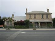
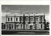
North Fremantle Post Office (former Police Station, Lockup and Quarters) is a two-storey limestone building of domestic scale, built in 1898. It was designed for the Government of Western Australia by the Public Works Department. It is sited on Queen Victoria Street (formerly Perth Road) and, by 1903, the North Fremantle Post Office (former Police Station, Lockup and Quarters) was part of a busy main street, with shops either side and a new Town Hall just down the road. The building is of limestone with stylistic elements of the Victorian Georgian style combined in the picturesque asymmetry favoured by the Arts and Crafts movement of the same period. The building has exposed stonewalling, simple rectangular openings with rendered sills and lintels and comprises both single and two storey sections with a verandah to the east elevation. The massing of the group is asymmetrical with a fine balance between picturesque roof forms and the bulk of the double storey block and which, together with the stone work, gives the building a domestic ambience. The combination of public office, lock-up, and residential function is well composed and the form of the building follows the functional planning. The original plans for the building show a public office (charge room), exercise yard and three cells, with three sets of quarters attached. There are two double storey quarters with two upper floor bedrooms and a single storey, two bedroom, quarters with a connecting door to the police station. The quarters front the street, each with a small front yard and verandah. Front verandahs have screen walls of stone separating the residences and timber verandah posts complete with capitals, bases and brackets. The charge room is entered by a side porch on the south and has direct access to the exercise yard. The side porch to the charge room has the same posts and brackets and a spandrel panel of lattice. The cells open directly onto this yard. There are small iron barred windows over the doors and no other openings. The drawings show a latrine built into an arched alcove in the south wall. From Heritage Council of Western Australia's Register of Heritage Places - Register and Assessment Documentation.
Queen Victoria Street developed from the 1860s following the construction of the North Fremantle Traffic Bridge and the upgrading of Perth Road by convicts. Initially called Perth Road, the street has had a number of names over the years: Victoria Avenue (c.1907-c. 1937), Stirling Highway (c. 1937 to c. 1976) and Queen Victoria Street (c. 1976 on). The area bounded by Queen Victoria Street, Stirling Highway (previously Bruce Street) and John Street was the commercial and social centre of North Fremantle, where public buildings such as the town hall, police station and post office were located. Also in this vicinity were the pubs and wine bars, butchers, bakers, grocers, haberdashery and barbers shops that catered for the needs of the local community. Queen Victoria Street continues to be North Fremantle’s main commercial precinct in North Fremantle. This building was constructed in 1898 as the North Fremantle Police Station, Lockup and Quarters by the Western Australian Government to service the rapidly growing district of North Fremantle. Stables were located to the rear of the property across the right of way (now Jewell Parade). W B Hardwick of the Public Works Department designed the building under the direction of the Chief Architect, J H Grainger. Following a call for tenders issued in July 1897, J B Campbell was awarded the contract and work was completed in February 1898. The building was immediately occupied by one corporal, one mounted and two foot constables. The works comprised a public office (charge room), exercise yard and three cells with three attached residences. Little work was done until 1957, when plans were prepared to convert the exercise yard to a charge room. The stone wall to the south was removed and replaced with a new brick wall, and the building was given a new floor, roof and public entry. The three cells were combined into one. Following the closure of the Police Station in 1969, the North Fremantle Post Office moved into the premises and post boxes were placed in window openings and a porch built to the front. Located on the southern side of John Street, the original North Fremantle Post and Telegraph Office (1892) had been demolished to make way for road widening and postal services were temporarily moved to the Town Hall. In 1991, Australia Post leased out the section of the building occupied by postal services and the remainder of the building was used as Homeswest accommodation. This place was included in the 'North Fremantle Heritage Study' (1994) as a place contributing to the development and heritage of North Fremantle. It was also included in the list of heritage places in the City of Fremantle identified by the Fremantle Society (1979/80) - PURPLE -of architectural and historic significance in its own right. The place has also been included in the State Register of Heritage Places by the Heritage Council of Western Australia. Refer to the register entry and assessment documentation for further information.
High degree of integrity (original intent clear, current use compatible, high long term sustainability, restored). High degree of authenticity with much original fabric remaining. (These statements based on street survey only).
Condition assessed as good (assessed from streetscape survey only).
This information is provided voluntarily as a public service. The information provided is made available in good faith and is derived from sources believed to be reliable and accurate. However, the information is provided solely on the basis that readers will be responsible for making their own assessment of the matters discussed herein and are advised to verify all relevant representations, statements and information.
THe building constitutes a significant element in the streetscape. It is hostorically important through its former use as the North Fremantle Police Station and lock up.
The building is constructed of limestone with a corrugated asbestos roof. It has both single and double storied sections and there is a verandah with timber posts along the front that abuts a gable end. There are horizontal bands under the windows and large stone chimneys.
Assessment 1974 Construction 1890's Former Police Station & Lock up
This information is provided voluntarily as a public service. The information provided is made available in good faith and is derived from sources believed to be reliable and accurate. However, the information is provided solely on the basis that readers will be responsible for making their own assessment of the matters discussed herein and are advised to verify all relevant representations, statements and information.
219-221 Queen Victoria St North Fremantle
Fremantle
Metropolitan
| Type | Status | Date | Documents |
|---|---|---|---|
| Heritage List | YES | 08 Mar 2007 |
| Type | Status | Date | Documents |
|---|---|---|---|
| RHP - To be assessed | Current | 25 Jan 2006 |
| Type | Status | Date | Grading/Management | |
|---|---|---|---|---|
| Category | ||||
| Municipal Inventory | Adopted | 18 Sep 2000 | Level 2 | |
03794 North Fremantle Town Centre Precinct
Individual Building or Group
| Epoch | General | Specific |
|---|---|---|
| Present Use | COMMERCIAL | Shop\Retail Store {single} |
| Original Use | OTHER | Other |
| Style |
|---|
| Victorian Regency |
| Type | General | Specific |
|---|---|---|
| Wall | BRICK | Rendered Brick |
| Wall | BRICK | Painted Brick |
| General | Specific |
|---|---|
| OCCUPATIONS | Commercial & service industries |
| DEMOGRAPHIC SETTLEMENT & MOBILITY | Land allocation & subdivision |
This information is provided voluntarily as a public service. The information provided is made available in good faith and is derived from sources believed to be reliable and accurate. However, the information is provided solely on the basis that readers will be responsible for making their own assessment of the matters discussed herein and are advised to verify all relevant representations, statements and information.
Constructed from 1907
Commercial Building, 219-221 Queen Victoria Street is a typical painted and rendered brick, single storey commercial shop dating from the1900s. The place has aesthetic value for its contribution to the streetscape and the surrounding area. It is representative of the typical commercial building stock located within the commercial areas of North Fremantle. Historically significant as a representation of commercial buildings in the North Fremantle area. The place is a late, simple example of the Victorian Regency style of architecture.
Commercial Building, 219-221 Queen Victoria Street is a single storey rendered and painted brick and iron commercial building designed as a late example of the Victorian Regency style of architecture, formerly comprising two tenancies. Each of the tenancies retains its recessed shop entrance. A simply detailed building; it is not attached to other commercial buildings. Simple pilasters separate the building form into its individual shops on the facade. There is a banded stucco moulding and a simply detailed parapet with stucco moulding ornaments. A rendered corbelled chimney remains intact for one shop, a elaborately ornamented pediment on the other. In 2016 the place is a single commercial building which contains a bottle shop.
Queen Victoria Street developed from the 1860s following the construction of the North Fremantle Traffic Bridge and the upgrading of Perth Road by convicts. Initially called Perth Road, the street has had a number of names over the years: Victoria Avenue (c.1907-c. 1937), Stirling Highway (c. 1937 to c. 1976) and Queen Victoria Street (c. 1976 on). The area bounded by Queen Victoria Street, Stirling Highway (previously Bruce Street) and John Street was the commercial and social centre of North Fremantle, where public buildings such as the town hall, police station and post office were located. Also in this vicinity were the pubs and wine bars, butchers, bakers, grocers, haberdashery and barbers shops that catered for the needs of the local community. Queen Victoria Street continues to be North Fremantle’s main commercial precinct in North Fremantle. A comparison of available sewerage plans would indicate that the building at 219-221 Queen Victoria Street was constructed c. 1907 for Currie and Murray, grocers. (It was built on the site of an earlier shop that was extant in 1897 and occupied by Currie and Co grocers). The building comprised two shop fronts, each with a central entrance. A bakehouse was also located on the site in 1920s. Circa 1940, the rear of number 219 (then 19 Stirling Highway) was galvanised iron, while number 221 (then 21 Stirling Highway) was a long brick shop that extended to the rear of the block. Currie and Munday continued to occupy the shops until at least the 1930s. In 1945, the shops were occupied by Jones Brothers, grocers and ironmongers. Old Bridge Cellars have occupied the building since the late 1980s. This place was included in the 'North Fremantle Heritage Study' (1994) as a place contributing to the development and heritage of North Fremantle. It was also included in the list of heritage places in the City of Fremantle identified by the Fremantle Society (1979/80) - RED -significant for contributing to the unique character of Fremantle.
Moderate degree of integrity (original intent clear, current use compatible, high long term sustainability, partially restored, some loss of fabric). Moderate degree of authenticity with basic original fabric remaining.Some loss of fabric. (These statements based on street survey only).
Condition assessed as good (assessed from streetscape survey only).
This information is provided voluntarily as a public service. The information provided is made available in good faith and is derived from sources believed to be reliable and accurate. However, the information is provided solely on the basis that readers will be responsible for making their own assessment of the matters discussed herein and are advised to verify all relevant representations, statements and information.
222 Queen Victoria St North Fremantle
Includes the former North Fremantle Town Hall (1902), the Literary Institute (1906), a former tramway depot (now used as a store), a separate workshop building, a toilet block and a store. At the rear is a building that appears to be an electricity sub-station with an unusual vent on the apex of the roof.
Fremantle
Metropolitan
Constructed from 1902 to 1906
| Type | Status | Date | Documents |
|---|---|---|---|
| Heritage List | YES | 08 Mar 2007 | |
| State Register | Registered | 11 Mar 1997 | HCWebsite.Listing+ListingDocument, HCWebsite.Listing+ListingDocument |
| Type | Status | Date | Documents |
|---|---|---|---|
| (no listings) |
| Type | Status | Date | Grading/Management | |
|---|---|---|---|---|
| Category | ||||
| Classified by the National Trust | Classified | 03 Nov 1980 | ||
| Register of the National Estate | Permanent | 28 Sep 1982 | ||
| Municipal Inventory | Adopted | 18 Sep 2000 | Level 1A | |
03794 North Fremantle Town Centre Precinct
| Name | Type | Year From | Year To |
|---|---|---|---|
| J F Allen | Architect | - | - |
| J F Allen, Architect (1906 additions) | Architect | - | - |
| Mr George Clark | Architect | - | - |
| Library Id | Title | Medium | Year Of Publication |
|---|
Individual Building or Group
| Epoch | General | Specific |
|---|---|---|
| Present Use | GOVERNMENTAL | Office or Administration Bldg |
| Original Use | GOVERNMENTAL | Office or Administration Bldg |
| Original Use | GOVERNMENTAL | Town, Shire or District Hall |
| Original Use | MONUMENT\CEMETERY | Monument |
| Present Use | COMMERCIAL | Shop\Retail Store {single} |
| Original Use | EDUCATIONAL | Library |
| Style |
|---|
| Federation Free Classical |
| Type | General | Specific |
|---|---|---|
| Roof | METAL | Corrugated Iron |
| Wall | RENDER | Smooth |
| Wall | BRICK | Rendered Brick |
| General | Specific |
|---|---|
| SOCIAL & CIVIC ACTIVITIES | Government & politics |
| SOCIAL & CIVIC ACTIVITIES | Cultural activities |
| SOCIAL & CIVIC ACTIVITIES | Community services & utilities |
| OUTSIDE INFLUENCES | World Wars & other wars |
This information is provided voluntarily as a public service. The information provided is made available in good faith and is derived from sources believed to be reliable and accurate. However, the information is provided solely on the basis that readers will be responsible for making their own assessment of the matters discussed herein and are advised to verify all relevant representations, statements and information.
Constructed from 1902, Constructed from 1906
Register of Heritage Places - Permanent Entry North Fremantle Town Hall (fmr) North Fremantle Town Hall (fmr), built of stuccoed brickwork, is two storeyed at the street facade and is heavily embellished with corinthian columns and pilasters, comprising North Fremantle Town Hall (1902) and Library Institute (1906), has cultural heritage significance for the following reasons: the place demonstrates the past prosperity of the Town of North Fremantle, reflecting the confidence of the town's civic leaders at the turn-of-the-century; the place is a fine example of Federation Free Classical architecture, demonstrating a high quality of architectural detailing and craftsmanship; the place is a landmark in North Fremantle; the place is an important part of the streetscape of Stirling Highway, North Fremantle; the place contributes to the North Fremantle community's sense of place and the history of the Town of North Fremantle; and, the place, together with the former Municipal Gardens and the War Memorial, defines a former civic precinct.
The former North Fremantle Town Hall, comprising North Fremantle Town Hall (1902), Library Institute (1906) and former tramways shed to the rear, is a two storey rendered brick building designed in the Federation Free Classical style of architecture. It is an imposing and unusual building located on the western side of Stirling Highway in the commercial centre of North Fremantle. The place is bounded by Queen Victoria Street to the west and Harvest Road to the south. The building is adjacent to the former Municipal Garden and War Memorial. The walls are rendered brick embellished with corinthian columns and pilasters. The originally symmetrical facade was extended north in 1906 to accommodate a Literary Institute. The facade is dominated by complex and heavily embellished treatments on the upper level of the original building which contrasts with the austere treatment on the lower level and both levels of the addition. The original building has a facade of projections and recessions. It has five bays, the central and end bays project beyond the wall alignment. The upper level bays are framed by a corinthian order, with unfluted shafts, supported by consoles. The order carries an entablature and a parapet concealing the roof. The shafts of the corinthian order feature festoons. Each bay contains round arched sash windows recessed behind the outer face of the building. The windows have deep cut moulded architraves that are connected at their springing point by corinthian pilasters. No attempt was made to replicate the treatment of the original facade on the two-storey addition. Although in keeping with the rhythm of the original building, the texture and the features of the exterior are unrelated. The street facade is recessed behind the original building and is divided into two bays. The articulation of the lower level is given a horizontal emphasis with banded wall treatment unrelated to any other part of the building, and vertical emphasis with a free interpretation of a Palladian motif of three arched openings, accentuated keystones and rendered dressings. The upper level features square sash windows with moulded semi-circular arch surrounds and accentuated keystones. A retail outlet of antique furniture occupies the former offices and hall on the lower level of the building. The building owner occupies the former ancillary accommodation on the upper level. (This information is sourced from the HCWA Assessment Documentation)
Queen Victoria Street developed from the 1860s following the construction of the North Fremantle Traffic Bridge and the upgrading of Perth Road by convicts. Initially called Perth Road, the street has had a number of names over the years: Victoria Avenue (c.1907-c. 1937), Stirling Highway (c. 1937 to c. 1976) and Queen Victoria Street (c. 1976 on). The area bounded by Queen Victoria Street, Stirling Highway (previously Bruce Street) and John Street was the commercial and social centre of North Fremantle, where public buildings such as the town hall, police station and post office were located. Also in this vicinity were the pubs and wine bars, butchers, bakers, grocers, haberdashery and barbers shops that catered for the needs of the local community. Queen Victoria Street continues to be North Fremantle’s main commercial precinct in North Fremantle. Following the creation of the North Fremantle Municipality in 1895, the North Fremantle Councillors initially met in the Masons Hall in John Street. In the early 1900s, the Council decided to build new chambers near the Municipal Gardens in Victoria Avenue and commissioned G Clark to prepare a design. The foundation stone for the building was laid in September 1902 and the building was completed by Garrick and Ford in 1903. In addition to its municipal function, the hall was used for local dances and concerts, school balls, and ratepayers and public meetings. It also housed a cinema for many years. A two-storey addition designed by architect J F Allen was made to the Town Hall in 1906 to accommodate the Literary Institute. According to a local newspaper the new Literary Institute was ‘... commodious and well ventilated ... There is a capital selection of books, and all the newspapers and magazines are provided’. Following the amalgamation of the North Fremantle Municipal Council with the Fremantle City Council in November 1961, the North Fremantle Town Hall became redundant and was sold at public auction in April 1966. Since that time, the hall has had a variety of purposes, including headquarters for the West Australian Ballet Company (1977-80), Fremantle Community School, Arts Centre, yoga school and several workshops. Some renovation work was carried out in the mid-1980s. In 1993, the building was sold to antique dealers and has been used as an antique showroom since that time. This place was included in the 'North Fremantle Heritage Study' (1994) as a place contributing to the development and heritage of North Fremantle. It was also included in the list of heritage places in the City of Fremantle identified by the Fremantle Society (1979/80) - PURPLE -of architectural and historic significance in its own right. The place has also been included in the State Register of Heritage Places by the Heritage Council of Western Australia. Refer to the register entry and assessment documentation for further information.
High degree of integrity (original intent clear, current use compatible despite loss of original function in 1960s, high long term sustainability, restored, sympathetic extensions and minor modifications). High degree of authenticity with much original fabric remaining. (These statements based on street survey only).
Condition assessed as good (assessed from streetscape survey only).
| Name | Type | Year From | Year To |
|---|---|---|---|
| J F Allen, Architect (1906 additions) | Architect | - | - |
This information is provided voluntarily as a public service. The information provided is made available in good faith and is derived from sources believed to be reliable and accurate. However, the information is provided solely on the basis that readers will be responsible for making their own assessment of the matters discussed herein and are advised to verify all relevant representations, statements and information.
227 Queen Victoria St North Fremantle
Fremantle
Metropolitan
| Type | Status | Date | Documents |
|---|---|---|---|
| (no listings) |
| Type | Status | Date | Documents |
|---|---|---|---|
| RHP - To be assessed | Current | 25 Jan 2006 |
| Type | Status | Date | Grading/Management | |
|---|---|---|---|---|
| Category | ||||
| Municipal Inventory | Adopted | 14 Dec 2016 | Historical Record Only | |
03794 North Fremantle Town Centre Precinct
Individual Building or Group
| Epoch | General | Specific |
|---|---|---|
| Original Use | RELIGIOUS | Church Hall |
This information is provided voluntarily as a public service. The information provided is made available in good faith and is derived from sources believed to be reliable and accurate. However, the information is provided solely on the basis that readers will be responsible for making their own assessment of the matters discussed herein and are advised to verify all relevant representations, statements and information.
Constructed from 1907, Constructed from 1897
DEMOLISHED. Retained on MHI for historical information only.
Queen Victoria Street developed from the 1860s following the construction of the North Fremantle Traffic Bridge and the upgrading of Perth Road by convicts. Initially called Perth Road, the street has had a number of names over the years: Victoria Avenue (c.1907-c. 1937), Stirling Highway (c. 1937 to c. 1976) and Queen Victoria Street (c. 1976 on). The area bounded by Queen Victoria Street, Stirling Highway (previously Bruce Street) and John Street was the commercial and social centre of North Fremantle, where public buildings such as the town hall, police station and post office were located. Also in this vicinity were the pubs and wine bars, butchers, bakers, grocers, haberdashery and barbers shops that catered for the needs of the local community. Queen Victoria Street continues to be North Fremantle’s main commercial precinct in North Fremantle. The Wesylan Church built a weatherboard hall (known as the Methodist Hall) at this site sometime between 1897 and 1907. The Hall has been demolished. This place was included in the 'North Fremantle Heritage Study' (1994) as a place contributing to the development and heritage of North Fremantle. It was also included in the list of heritage places in the City of Fremantle identified by the Fremantle Society (1979/80) - RED -significant for contributing to the unique character of Fremantle.
This information is provided voluntarily as a public service. The information provided is made available in good faith and is derived from sources believed to be reliable and accurate. However, the information is provided solely on the basis that readers will be responsible for making their own assessment of the matters discussed herein and are advised to verify all relevant representations, statements and information.
229 Queen Victoria St North Fremantle
Fremantle
Metropolitan
| Type | Status | Date | Documents |
|---|---|---|---|
| Heritage List | YES | 08 Mar 2007 |
| Type | Status | Date | Documents |
|---|---|---|---|
| RHP - To be assessed | Current | 25 Jan 2006 |
| Type | Status | Date | Grading/Management | |
|---|---|---|---|---|
| Category | ||||
| Municipal Inventory | Adopted | 18 Sep 2000 | Level 2 | |
03794 North Fremantle Town Centre Precinct
Individual Building or Group
| Epoch | General | Specific |
|---|---|---|
| Present Use | COMMERCIAL | Shop\Retail Store {single} |
| Original Use | RELIGIOUS | Church, Cathedral or Chapel |
| Style |
|---|
| Federation Romanesque |
| Type | General | Specific |
|---|---|---|
| Wall | STONE | Limestone |
| Wall | BRICK | Common Brick |
| Roof | METAL | Corrugated Iron |
| General | Specific |
|---|---|
| OCCUPATIONS | Commercial & service industries |
| SOCIAL & CIVIC ACTIVITIES | Religion |
This information is provided voluntarily as a public service. The information provided is made available in good faith and is derived from sources believed to be reliable and accurate. However, the information is provided solely on the basis that readers will be responsible for making their own assessment of the matters discussed herein and are advised to verify all relevant representations, statements and information.
Constructed from 1904, Constructed from 1907
Former Church, 229 Queen Victoria Street, is a typical stone and iron church building dating from the turn of the twentieth century. The place has aesthetic value for its contribution to the streetscape and the surrounding area. It is representative of turn of the Century stone churches located within Fremantle. The place is a example of the Federation Romanesque style of architecture.
Former Church, 229 Queen Victoria Street, is a simple stone brick and iron church building with symmetrical facade designed as a simple example of the Federation Romanesque style of architecture. The building is at street street level with bitumen areas from the front elevation to the road verge. Walls are stone with red brick reveals. The roof is a simple gable with no eaves. The front elevation is symmetrical with two timber sash semi circular headed windows, a central highlight semi circular headed window and an arched central front door. In 2016 the place is used as an antique shop.
Queen Victoria Street developed from the 1860s following the construction of the North Fremantle Traffic Bridge and the upgrading of Perth Road by convicts. Initially called Perth Road, the street has had a number of names over the years: Victoria Avenue (c.1907-c. 1937), Stirling Highway (c. 1937 to c. 1976) and Queen Victoria Street (c. 1976 on). The area bounded by Queen Victoria Street, Stirling Highway (previously Bruce Street) and John Street was the commercial and social centre of North Fremantle, where public buildings such as the town hall, police station and post office were located. Also in this vicinity were the pubs and wine bars, butchers, bakers, grocers, haberdashery and barbers shops that catered for the needs of the local community. Queen Victoria Street continues to be North Fremantle’s main commercial precinct in North Fremantle. Constructed between 1904 and 1907, the Wesylan Church was one of a number of churches built in North Fremantle during this period. The use of brick, rather than limestone, reflects the prominent use of brick as the preferred building material from the 1890s. A weatherboard hall constructed (known as the Methodist Hall) was built on the same site (to the north) sometime between 1897 and 1907. In 2004 the place was being used as an antique shop and remains so in 2016. This place was included in the 'North Fremantle Heritage Study' (1994) as a place contributing to the development and heritage of North Fremantle. It was also included in the list of heritage places in the City of Fremantle identified by the Fremantle Society (1979/80) - RED -significant for contributing to the unique character of Fremantle.
Moderate degree of integrity (original intent clear, current use compatible, high long term sustainability, partially restored, some loss of fabric and previous unsympathetic alterations). Moderate degree of authenticity with basic original fabric remaining.Some loss of fabric. (These statements based on street survey only).
Condition assessed as good (assessed from streetscape survey only).
This information is provided voluntarily as a public service. The information provided is made available in good faith and is derived from sources believed to be reliable and accurate. However, the information is provided solely on the basis that readers will be responsible for making their own assessment of the matters discussed herein and are advised to verify all relevant representations, statements and information.
231 Queen Victoria St North Fremantle
Fremantle
Metropolitan
| Type | Status | Date | Documents |
|---|---|---|---|
| Heritage List | YES | 08 Mar 2007 |
| Type | Status | Date | Documents |
|---|---|---|---|
| RHP - To be assessed | Current | 25 Jan 2006 |
| Type | Status | Date | Grading/Management | |
|---|---|---|---|---|
| Category | ||||
| Municipal Inventory | Adopted | 18 Sep 2000 | Level 3 | |
03794 North Fremantle Town Centre Precinct
Individual Building or Group
| Epoch | General | Specific |
|---|---|---|
| Original Use | RESIDENTIAL | Single storey residence |
| Present Use | COMMERCIAL | Shop\Retail Store {single} |
| Style |
|---|
| Victorian Georgian |
| Type | General | Specific |
|---|---|---|
| Roof | METAL | Corrugated Iron |
| Wall | TIMBER | Weatherboard |
| General | Specific |
|---|---|
| DEMOGRAPHIC SETTLEMENT & MOBILITY | Land allocation & subdivision |
This information is provided voluntarily as a public service. The information provided is made available in good faith and is derived from sources believed to be reliable and accurate. However, the information is provided solely on the basis that readers will be responsible for making their own assessment of the matters discussed herein and are advised to verify all relevant representations, statements and information.
Constructed from 1895
House, 231 Queen Victoria Street, is a typical weatherboard and iron single storey cottage dating from the 1890s. The place has aesthetic value for its contribution to the streetscape and the surrounding area. It is representative of the typical building stock located within the residential areas of North Fremantle. Historically significant as a representation of typical workers' houses in the North Fremantle area. The place is a simple example of the Victorian Georgian style of architecture.
House, 231 Queen Victoria Street, is a single storey weatherboard and iron cottage with symmetrical facade designed as a late example of the Victorian Georgian style of architecture. It was originally a duplex pair of cottages. Walls are timber framed clad with painted weatherboards. The roof is hipped corrugated iron with no eaves. The central gable over the double front entrance appears to be a more recent addition. The verandah is under a separate corrugated iron roof, which is supported by chamfered timber posts with decorative metal brackets. The front elevation is symmetrical with two timber sash windows and a double size central front door (not original). The verandah is slightly raised above ground level and has a brick paved floor behind a low timber picket fence. The place has undergone alterations and is in use as a beauty salon (2016).
Queen Victoria Street developed from the 1860s following the construction of the North Fremantle Traffic Bridge and the upgrading of Perth Road by convicts. Initially called Perth Road, the street has had a number of names over the years: Victoria Avenue (c.1907-c. 1937), Stirling Highway (c. 1937 to c. 1976) and Queen Victoria Street (c. 1976 on). The area bounded by Queen Victoria Street, Stirling Highway (previously Bruce Street) and John Street was the commercial and social centre of North Fremantle, where public buildings such as the town hall, police station and post office were located. Also in this vicinity were the pubs and wine bars, butchers, bakers, grocers, haberdashery and barbers shops that catered for the needs of the local community. Queen Victoria Street continues to be North Fremantle’s main commercial precinct in North Fremantle. The duplex at 231 Queen Victoria Street is shown on a sewerage plan dated 1897. Both residences were recorded as comprising three rooms in the 1921/22 rate books. The land was part of a large holding along Queen Victoria Street owned by Kathleen Kenny. In 1924, 29 Victoria Avenue (later 29 Stirling Highway and then 231 Queen Victoria Street) was vacant, while number 31 was occupied by William Water. During the 1930s, Gordon Dedman was listed as the occupant of both residences. Dedman operated a butcher shop in the adjacent shop at 33 Victoria Avenue (now part of 237 Queen Victoria Street). In 1945, Florence Rawlings lived in number 29 while Walter Hatch lived at number 31. This place was included in the 'North Fremantle Heritage Study' (1994) as a place contributing to the development and heritage of North Fremantle. It was also included in the list of heritage places in the City of Fremantle identified by the Fremantle Society (1979/80) - RED -significant for contributing to the unique character of Fremantle.
Moderate degree of integrity (original intent clear, current use compatible, high long term sustainability, partially restored, some loss of fabric and previous unsympathetic alterations). Moderate degree of authenticity with basic original fabric remaining.Some loss of fabric. (These statements based on street survey only).
Condition assessed as good (assessed from streetscape survey only).
This information is provided voluntarily as a public service. The information provided is made available in good faith and is derived from sources believed to be reliable and accurate. However, the information is provided solely on the basis that readers will be responsible for making their own assessment of the matters discussed herein and are advised to verify all relevant representations, statements and information.
237 Queen Victoria St North Fremantle
Mojo's Bar and Cafe
Fremantle
Metropolitan
| Type | Status | Date | Documents |
|---|---|---|---|
| Heritage List | YES | 08 Mar 2007 |
| Type | Status | Date | Documents |
|---|---|---|---|
| RHP - To be assessed | Current | 25 Jan 2006 |
| Type | Status | Date | Grading/Management | |
|---|---|---|---|---|
| Category | ||||
| Municipal Inventory | Adopted | 18 Sep 2000 | Level 2 | |
03794 North Fremantle Town Centre Precinct
Individual Building or Group
| Epoch | General | Specific |
|---|---|---|
| Present Use | COMMERCIAL | Shop\Retail Store {single} |
| Original Use | COMMERCIAL | Shop\Retail Store {single} |
| Style |
|---|
| Victorian Regency |
| Type | General | Specific |
|---|---|---|
| Wall | BRICK | Painted Brick |
| Wall | BRICK | Rendered Brick |
| General | Specific |
|---|---|
| DEMOGRAPHIC SETTLEMENT & MOBILITY | Land allocation & subdivision |
| OCCUPATIONS | Commercial & service industries |
This information is provided voluntarily as a public service. The information provided is made available in good faith and is derived from sources believed to be reliable and accurate. However, the information is provided solely on the basis that readers will be responsible for making their own assessment of the matters discussed herein and are advised to verify all relevant representations, statements and information.
Constructed from 1913, Constructed from 1904
Commercial Building, 237 Queen Victoria Street is a typical painted and rendered brick,single storey commercial shop dating from the1900s. The place has aesthetic value for its contribution to the streetscape and the surrounding area. It is representative of the typical commercial building stock located within the commercial areas of North Fremantle. Historically significant as a representation of commercial buildings in the North Fremantle area. The place is a late, simple example of the Victorian Regency style of architecture.
Commercial Building, 237 Queen Victoria Street is a single storey rendered and painted brick and iron commercial building designed in the Victorian Regency style of architecture, formerly comprising three tenancies. Each of the tenancies had traditional recessed shop entrances and protruding display windows. Simple pilasters separate the building form into its individual shops on the facade. These are continued through the banded stucco moulding and the simply detailed parapet.
Queen Victoria Street developed from the 1860s following the construction of the North Fremantle Traffic Bridge and the upgrading of Perth Road by convicts. Initially called Perth Road, the street has had a number of names over the years: Victoria Avenue (c.1907-c. 1937), Stirling Highway (c. 1937 to c. 1976) and Queen Victoria Street (c. 1976 on). The area bounded by Queen Victoria Street, Stirling Highway (previously Bruce Street) and John Street was the commercial and social centre of North Fremantle, where public buildings such as the town hall, police station and post office were located. Also in this vicinity were the pubs and wine bars, butchers, bakers, grocers, haberdashery and barbers shops that catered for the needs of the local community. Queen Victoria Street continues to be North Fremantle’s main commercial precinct in North Fremantle. A single storey brick and iron commercial building comprising three tenancies at 237 Queen Victoria Street (previously 33-37 Victoria Avenue and 33-37 Stirling Highway) was constructed between 1904 and 1913. The land was part of a large holding along Queen Victoria Street owned by Kathleen Kenny. A plan dated 1940 shows a brick building with no set-back from the street, with various brick and corrugated iron outbuildings to the rear. Each of the tenancies had traditional shop entrances. In 1924, the shops were occupied by Harris and Dedman, butchers, William Jeffries, a bootmaker, John Pope, and Mrs Ellen Worth’s tearooms. The tenancies remained the same in 1935 (though A Lopes had taken over Jeffries’ bootmaking business). In 1945, G T Dedman remained at number 33, number 35 was vacant, and George Powell operated refreshment rooms from number 37. (Powell also had refreshment rooms at number 55 Stirling Highway at this time). This place was included in the 'North Fremantle Heritage Study' (1994) as a place contributing to the development and heritage of North Fremantle. It was also included in the list of heritage places in the City of Fremantle identified by the Fremantle Society (1979/80) - RED -significant for contributing to the unique character of Fremantle. In the 1970s through to c1990 the place was ‘The Stoned Crow’. It had a bar called Mojos. It is currently (2016) popular live music venue Mojo’s Bar & Cafe.
Moderate to high degree of integrity (original intent clear, current use compatible, high long term sustainability, partially restored, some loss of fabric and previous unsympathetic alterations). Moderate degree of authenticity with basic original fabric remaining.Some loss of fabric. (These statements based on street survey only).
Condition assessed as good (assessed from streetscape survey only).
This information is provided voluntarily as a public service. The information provided is made available in good faith and is derived from sources believed to be reliable and accurate. However, the information is provided solely on the basis that readers will be responsible for making their own assessment of the matters discussed herein and are advised to verify all relevant representations, statements and information.
239 Queen Victoria St North Fremantle
Fremantle
Metropolitan
| Type | Status | Date | Documents |
|---|---|---|---|
| Heritage List | YES | 08 Mar 2007 |
| Type | Status | Date | Documents |
|---|---|---|---|
| RHP - To be assessed | Current | 25 Jan 2006 |
| Type | Status | Date | Grading/Management | |
|---|---|---|---|---|
| Category | ||||
| Municipal Inventory | Adopted | 18 Sep 2000 | Level 2 | |
03794 North Fremantle Town Centre Precinct
Individual Building or Group
| Epoch | General | Specific |
|---|---|---|
| Present Use | COMMERCIAL | Shop\Retail Store {single} |
| Original Use | COMMERCIAL | Shop\Retail Store {single} |
| Style |
|---|
| Victorian Regency |
| Type | General | Specific |
|---|---|---|
| Wall | BRICK | Rendered Brick |
| Wall | BRICK | Painted Brick |
| General | Specific |
|---|---|
| OCCUPATIONS | Commercial & service industries |
| DEMOGRAPHIC SETTLEMENT & MOBILITY | Land allocation & subdivision |
This information is provided voluntarily as a public service. The information provided is made available in good faith and is derived from sources believed to be reliable and accurate. However, the information is provided solely on the basis that readers will be responsible for making their own assessment of the matters discussed herein and are advised to verify all relevant representations, statements and information.
Constructed from 1904, Constructed from 1913
Commercial Building, 239 Queen Victoria Street is a typical rendered brick, two storey commercial shop with residence above dating from the 1900s. The place has aesthetic value for its contribution to the streetscape and the surrounding area. It is representative of the typical commercial building stock located within the commercial areas of North Fremantle. Historically significant as a representation of commercial buildings in the North Fremantle area. The place is a late, simple example of the Victorian Regency style of architecture.
Two storey, rendered and painted brick building designed in the Victorian Regency style of architecture. A simply detailed building, it is part of an attached row of commercial shops with residences above. The attached building is detailed in a similar manner. The original verandahs have been replaced with flat metal awnings. Within itself the front facade is symmetrical with three pairs of upper floor windows with simple rendered architraves. There is a simple banded moulding detail to the parapet and a half sun motif. There are two glass shop fronts to the ground floor.
Queen Victoria Street developed from the 1860s following the construction of the North Fremantle Traffic Bridge and the upgrading of Perth Road by convicts. Initially called Perth Road, the street has had a number of names over the years: Victoria Avenue (c.1907-c. 1937), Stirling Highway (c. 1937 to c. 1976) and Queen Victoria Street (c. 1976 on). The area bounded by Queen Victoria Street, Stirling Highway (previously Bruce Street) and John Street was the commercial and social centre of North Fremantle, where public buildings such as the town hall, police station and post office were located. Also in this vicinity were the pubs and wine bars, butchers, bakers, grocers, haberdashery and barbers shops that catered for the needs of the local community. Queen Victoria Street continues to be North Fremantle’s main commercial precinct in North Fremantle. Comprising four retail tenancies, this building was constructed between 1904 and 1913. A plan dated 1940 shows a brick building with a galvanised iron addition at the rear and various outbuildings. The land was part of a large holding along Queen Victoria Street owned by Kathleen Kenny. In 1924, King and Co, fruiterer, occupied the shop at 39 Victoria Avenue (later 39 Stirling Highway, then 239 Queen Victoria Street). King and Co remained until c. 1940. In 1945, the shop was occupied by Arthur Johnstone, greengrocer. This place was included in the 'North Fremantle Heritage Study' (1994) as a place contributing to the development and heritage of North Fremantle. It was also included in the list of heritage places in the City of Fremantle identified by the Fremantle Society (1979/80) - RED -significant for contributing to the unique character of Fremantle. The building was occupied by an antique shop in 2010. As at 2016 it is Flipside Burgers.
Moderate degree of integrity (original intent clear, current use compatible, high long term sustainability, partially restored, some loss of fabric and previous unsympathetic alterations). Moderate degree of authenticity with basic original fabric remaining.Some loss of fabric. (These statements based on street survey only).
Condition assessed as good (assessed from streetscape survey only).
This information is provided voluntarily as a public service. The information provided is made available in good faith and is derived from sources believed to be reliable and accurate. However, the information is provided solely on the basis that readers will be responsible for making their own assessment of the matters discussed herein and are advised to verify all relevant representations, statements and information.
239 Queen Victoria St North Fremantle
Fremantle
Metropolitan
| Type | Status | Date | Documents |
|---|---|---|---|
| Heritage List | YES | 08 Mar 2007 |
| Type | Status | Date | Documents |
|---|---|---|---|
| (no listings) |
| Type | Status | Date | Grading/Management | |
|---|---|---|---|---|
| Category | ||||
| Municipal Inventory | Adopted | 14 Dec 2016 | Historical Record Only | |
Historic site
| Epoch | General | Specific |
|---|---|---|
| Original Use | OTHER | Other |
This information is provided voluntarily as a public service. The information provided is made available in good faith and is derived from sources believed to be reliable and accurate. However, the information is provided solely on the basis that readers will be responsible for making their own assessment of the matters discussed herein and are advised to verify all relevant representations, statements and information.
DEMOLISHED. Retained on MHI for historical information only.
This place was identified in the "Heritage Report on 19th century limestone walls and steps in Fremantle" prepared by Silvana Grassadonia, for the City of Fremantle, 1986. It has since been demolished. The use of limestone is part of the Fremantle landscape and gives the City coherence and character. Limestone walls were built around properties in Fremantle to prevent sand drift in response to an early building regulation dating from the 1830s. Limestone walls are one commonly encountered example of use of this stone as a building material, most of them dating from the 19th century and early years of the 20th century. Most of the limestone in small walls came from local quarries.
This information is provided voluntarily as a public service. The information provided is made available in good faith and is derived from sources believed to be reliable and accurate. However, the information is provided solely on the basis that readers will be responsible for making their own assessment of the matters discussed herein and are advised to verify all relevant representations, statements and information.
241 Queen Victoria St North Fremantle
Fremantle
Metropolitan
| Type | Status | Date | Documents |
|---|---|---|---|
| Heritage List | YES | 08 Mar 2007 |
| Type | Status | Date | Documents |
|---|---|---|---|
| RHP - To be assessed | Current | 25 Jan 2006 |
| Type | Status | Date | Grading/Management | |
|---|---|---|---|---|
| Category | ||||
| Municipal Inventory | Adopted | 18 Sep 2000 | Level 2 | |
03794 North Fremantle Town Centre Precinct
Individual Building or Group
| Epoch | General | Specific |
|---|---|---|
| Original Use | COMMERCIAL | Shop\Retail Store {single} |
| Present Use | COMMERCIAL | Shop\Retail Store {single} |
| Style |
|---|
| Victorian Regency |
| Type | General | Specific |
|---|---|---|
| Wall | BRICK | Rendered Brick |
| Wall | BRICK | Painted Brick |
| General | Specific |
|---|---|
| DEMOGRAPHIC SETTLEMENT & MOBILITY | Land allocation & subdivision |
| OCCUPATIONS | Commercial & service industries |
This information is provided voluntarily as a public service. The information provided is made available in good faith and is derived from sources believed to be reliable and accurate. However, the information is provided solely on the basis that readers will be responsible for making their own assessment of the matters discussed herein and are advised to verify all relevant representations, statements and information.
Constructed from 1913, Constructed from 1904
Commercial Building, 241 Queen Victoria Street is a typical rendered brick, two storey commercial shop with residence above dating from the1900s. The place has aesthetic value for its contribution to the streetscape and the surrounding area. It is representative of the typical commercial building stock located within the commercial areas of North Fremantle. Historically significant as a representation of commercial buildings in the North Fremantle area. The place is a late, simple example of the Victorian Regency style of architecture.
Two storey, rendered and painted brick building designed in the Victorian Regency style of architecture. A simply detailed building, it is part of an attached row of commercial shops with residences above. The attached building is detailed in a similar manner. The original verandahs have been replaced with flat metal awnings. Within itself the front facade is symmetrical with three pairs of upper floor windows with simple rendered architraves. There is a simple banded moulding detail to the parapet and a half sun motif. There are two glass shop fronts to the ground floor. A Heritage Assessment was prepared in Nov 2009 by Heritage and Conservation Professionals for a DA submission to Council (DA0541/09) for proposed development of the rear courtyard at No 241.
Queen Victoria Street developed from the 1860s following the construction of the North Fremantle Traffic Bridge and the upgrading of Perth Road by convicts. Initially called Perth Road, the street has had a number of names over the years: Victoria Avenue (c.1907-c. 1937), Stirling Highway (c. 1937 to c. 1976) and Queen Victoria Street (c. 1976 on). The area bounded by Queen Victoria Street, Stirling Highway (previously Bruce Street) and John Street was the commercial and social centre of North Fremantle, where public buildings such as the town hall, police station and post office were located. Also in this vicinity were the pubs and wine bars, butchers, bakers, grocers, haberdashery and barbers shops that catered for the needs of the local community. Queen Victoria Street continues to be North Fremantle’s main commercial precinct in North Fremantle. Comprising four retail tenancies, this building was constructed between 1904 and 1913. A plan dated 1940 shows a brick building with a galvanised iron addition at the rear and various outbuildings. The land was part of a large holding along Queen Victoria Street owned by Kathleen Kenny. In 1924, the shop at 41 Victoria Avenue (later 41 Stirling Highway, then 241 Queen Victoria Street) was occupied by Alexander Willis’ refreshment rooms and La Tosca Studio, operated by A Orloff. Mrs D M Green operated a mixed business from the premises in 1935 and in 1945, the shop was vacant. This place was included in the 'North Fremantle Heritage Study' (1994) as a place contributing to the development and heritage of North Fremantle. It was also included in the list of heritage places in the City of Fremantle identified by the Fremantle Society (1979/80) - RED -significant for contributing to the unique character of Fremantle. The shop was occupied by a gift shop in 2009. A Heritage Assessment was prepared in Nov 2009 by Heritage and Conservation Professionals for a DA submission to Council (DA0541/09) for proposed development of the rear courtyard at No 241.
High degree of integrity (original intent clear, current use compatible, high long term sustainability). Medium degree of authenticity with some original fabric remaining. (These statements based on street survey only).
Condition assessed as good (assessed from streetscape survey only).
This information is provided voluntarily as a public service. The information provided is made available in good faith and is derived from sources believed to be reliable and accurate. However, the information is provided solely on the basis that readers will be responsible for making their own assessment of the matters discussed herein and are advised to verify all relevant representations, statements and information.
243 Queen Victoria St North Fremantle
Fremantle
Metropolitan
| Type | Status | Date | Documents |
|---|---|---|---|
| Heritage List | YES | 08 Mar 2007 |
| Type | Status | Date | Documents |
|---|---|---|---|
| RHP - To be assessed | Current | 25 Jan 2006 |
| Type | Status | Date | Grading/Management | |
|---|---|---|---|---|
| Category | ||||
| Municipal Inventory | Adopted | 18 Sep 2000 | Level 2 | |
03794 North Fremantle Town Centre Precinct
Individual Building or Group
| Epoch | General | Specific |
|---|---|---|
| Present Use | COMMERCIAL | Shop\Retail Store {single} |
| Original Use | COMMERCIAL | Shop\Retail Store {single} |
| Style |
|---|
| Victorian Regency |
| Type | General | Specific |
|---|---|---|
| Wall | BRICK | Rendered Brick |
| Wall | BRICK | Painted Brick |
| General | Specific |
|---|---|
| OCCUPATIONS | Commercial & service industries |
| DEMOGRAPHIC SETTLEMENT & MOBILITY | Land allocation & subdivision |
This information is provided voluntarily as a public service. The information provided is made available in good faith and is derived from sources believed to be reliable and accurate. However, the information is provided solely on the basis that readers will be responsible for making their own assessment of the matters discussed herein and are advised to verify all relevant representations, statements and information.
Constructed from 1913, Constructed from 1904
Commercial Building, 243 Queen Victoria Street is a typical rendered brick, two storey commercial shop with residence above dating from the 1900s. The place has aesthetic value for its contribution to the streetscape and the surrounding area. It is representative of the typical commercial building stock located within the commercial areas of North Fremantle. Historically significant as a representation of commercial buildings in the North Fremantle area. The place is a late, simple example of the Victorian Regency style of architecture.
Two storey, rendered and painted brick building designed in the Victorian Regency style of architecture. A simply detailed building, it is part of an attached row of commercial shops with residences above. The attached building is detailed in a similar manner. The original verandahs have been replaced with flat metal awnings. Within itself the front facade is asymmetrical with three individual and one pair of upper floor windows with simple rendered architraves. There is a simple banded moulding detail to the parapet and a half sun motif. There are two glass shop fronts to the ground floor.
Queen Victoria Street developed from the 1860s following the construction of the North Fremantle Traffic Bridge and the upgrading of Perth Road by convicts. Initially called Perth Road, the street has had a number of names over the years: Victoria Avenue (c.1907-c. 1937), Stirling Highway (c. 1937 to c. 1976) and Queen Victoria Street (c. 1976 on). The area bounded by Queen Victoria Street, Stirling Highway (previously Bruce Street) and John Street was the commercial and social centre of North Fremantle, where public buildings such as the town hall, police station and post office were located. Also in this vicinity were the pubs and wine bars, butchers, bakers, grocers, haberdashery and barbers shops that catered for the needs of the local community. Queen Victoria Street continues to be North Fremantle’s main commercial precinct in North Fremantle. Comprising four retail tenancies, this building was constructed between 1904 and 1913. A plan dated 1940 shows a brick building with a galvanised iron addition at the rear and various outbuildings. The land was part of a large holding along Queen Victoria Street owned by Kathleen Kenny. In 1924, the shop at 43 Victoria Avenue (later 43 Stirling Highway and then 243 Queen Victoria Street) was occupied by Edward Bennett, grocer, and Jos King, fruiterer. In 1935, the shop was occupied by P Giles, grocer and in 1945, Freecorns Ltd, grocers, were the tenants. The shop is now (2016) occupied by an antique shop. This place was included in the 'North Fremantle Heritage Study' (1994) as a place contributing to the development and heritage of North Fremantle. It was also included in the list of heritage places in the City of Fremantle identified by the Fremantle Society (1979/80) - RED -significant for contributing to the unique character of Fremantle.
Moderate degree of integrity (original intent clear, current use compatible, high long term sustainability, partially restored, some loss of fabric and previous unsympathetic alterations). Moderate degree of authenticity with basic original fabric remaining.Some loss of fabric. (These statements based on street survey only).
Condition assessed as good (assessed from streetscape survey only).
This information is provided voluntarily as a public service. The information provided is made available in good faith and is derived from sources believed to be reliable and accurate. However, the information is provided solely on the basis that readers will be responsible for making their own assessment of the matters discussed herein and are advised to verify all relevant representations, statements and information.
245 Queen Victoria St North Fremantle
Fremantle
Metropolitan
| Type | Status | Date | Documents |
|---|---|---|---|
| Heritage List | YES | 08 Mar 2007 |
| Type | Status | Date | Documents |
|---|---|---|---|
| RHP - To be assessed | Current | 25 Jan 2006 |
| Type | Status | Date | Grading/Management | |
|---|---|---|---|---|
| Category | ||||
| Municipal Inventory | Adopted | 18 Sep 2000 | Level 2 | |
03794 North Fremantle Town Centre Precinct
Individual Building or Group
| Epoch | General | Specific |
|---|---|---|
| Original Use | COMMERCIAL | Shop\Retail Store {single} |
| Present Use | COMMERCIAL | Shop\Retail Store {single} |
| Style |
|---|
| Victorian Regency |
| Type | General | Specific |
|---|---|---|
| Wall | BRICK | Rendered Brick |
| Wall | BRICK | Painted Brick |
| General | Specific |
|---|---|
| OCCUPATIONS | Commercial & service industries |
| DEMOGRAPHIC SETTLEMENT & MOBILITY | Land allocation & subdivision |
This information is provided voluntarily as a public service. The information provided is made available in good faith and is derived from sources believed to be reliable and accurate. However, the information is provided solely on the basis that readers will be responsible for making their own assessment of the matters discussed herein and are advised to verify all relevant representations, statements and information.
Constructed from 1913, Constructed from 1904
Commercial Building, 245 Queen Victoria Street is a typical rendered brick, two storey commercial shop with residence above dating from the1900s. The place has aesthetic value for its contribution to the streetscape and the surrounding area. It is representative of the typical commercial building stock located within the commercial areas of North Fremantle. Historically significant as a representation of commercial buildings in the North Fremantle area. The place is a late, simple example of the Victorian Regency style of architecture.
Two storey, rendered and painted brick building designed in the Victorian Regency style of architecture. A simply detailed building, it is part of an attached row of commercial shops with residences above. The attached building is detailed in a similar manner. The original verandahs have been replaced with flat metal awnings. Within itself the front facade is asymmetrical with three individual and one pair of upper floor windows with simple rendered architraves. There is a simple banded moulding detail to the parapet and a half sun motif. There are two glass shop fronts to the ground floor.
Queen Victoria Street developed from the 1860s following the construction of the North Fremantle Traffic Bridge and the upgrading of Perth Road by convicts. Initially called Perth Road, the street has had a number of names over the years: Victoria Avenue (c.1907-c. 1937), Stirling Highway (c. 1937 to c. 1976) and Queen Victoria Street (c. 1976 on). The area bounded by Queen Victoria Street, Stirling Highway (previously Bruce Street) and John Street was the commercial and social centre of North Fremantle, where public buildings such as the town hall, police station and post office were located. Also in this vicinity were the pubs and wine bars, butchers, bakers, grocers, haberdashery and barbers shops that catered for the needs of the local community. Queen Victoria Street continues to be North Fremantle’s main commercial precinct in North Fremantle. Comprising four retail tenancies, this building was constructed between 1904 and 1913. A plan dated 1940 shows a brick building with a galvanised iron addition at the rear and various outbuildings. The land was part of a large holding along Queen Victoria Street owned by Kathleen Kenny. Between c. 1920 and c. 1935, the shop at 45 Victoria Avenue (later 45 Stirling Highway and then 245 Queen Victoria Street) was occupied by Joseph King, fruiterer. By 1945, Edward Langridge had taken over the business. The place is now (2016) an antiques shop. This place was included in the 'North Fremantle Heritage Study' (1994) as a place contributing to the development and heritage of North Fremantle. It was also included in the list of heritage places in the City of Fremantle identified by the Fremantle Society (1979/80) - RED -significant for contributing to the unique character of Fremantle.
Moderate degree of integrity (original intent clear, current use compatible, high long term sustainability, partially restored, some loss of fabric and previous unsympathetic alterations). Moderate degree of authenticity with basic original fabric remaining.Some loss of fabric. (These statements based on street survey only).
Condition assessed as good (assessed from streetscape survey only).
This information is provided voluntarily as a public service. The information provided is made available in good faith and is derived from sources believed to be reliable and accurate. However, the information is provided solely on the basis that readers will be responsible for making their own assessment of the matters discussed herein and are advised to verify all relevant representations, statements and information.
255 Queen Victoria St North Fremantle
Fremantle
Metropolitan
| Type | Status | Date | Documents |
|---|---|---|---|
| Heritage List | YES | 08 Mar 2007 |
| Type | Status | Date | Documents |
|---|---|---|---|
| RHP - To be assessed | Current | 25 Jan 2006 |
| Type | Status | Date | Grading/Management | |
|---|---|---|---|---|
| Category | ||||
| Municipal Inventory | Adopted | 18 Sep 2000 | Level 2 | |
03794 North Fremantle Town Centre Precinct
Individual Building or Group
| Epoch | General | Specific |
|---|---|---|
| Present Use | COMMERCIAL | Shop\Retail Store {single} |
| Original Use | COMMERCIAL | Shop\Retail Store {single} |
| Style |
|---|
| Victorian Regency |
| Type | General | Specific |
|---|---|---|
| Wall | BRICK | Painted Brick |
| Wall | BRICK | Rendered Brick |
| General | Specific |
|---|---|
| DEMOGRAPHIC SETTLEMENT & MOBILITY | Land allocation & subdivision |
| OCCUPATIONS | Commercial & service industries |
This information is provided voluntarily as a public service. The information provided is made available in good faith and is derived from sources believed to be reliable and accurate. However, the information is provided solely on the basis that readers will be responsible for making their own assessment of the matters discussed herein and are advised to verify all relevant representations, statements and information.
Constructed from 1910
Commercial Building, 255 Queen Victoria Street is a typical rendered brick, two storey commercial shop with residence above dating from the 1910s. The place has aesthetic value for its contribution to the streetscape and the surrounding area. It is representative of the typical commercial building stock located within the commercial areas of North Fremantle. Historically significant as a representation of commercial buildings in the North Fremantle area. The place is a simple example of the Victorian Regency style of architecture.
Two storey, rendered and painted brick building designed in the Victorian Regency style of architecture. A simply detailed building, it is part of an attached row of commercial shops with residences above. The attached building is detailed in a similar manner. The original verandahs have been replaced with flat metal awnings. Within itself the front facade is symmetrical with a pair of upper floor windows with simple rendered architraves. There is a simple banded moulding detail to the parapet. There is a glass shop front to the ground floor.
Queen Victoria Street developed from the 1860s following the construction of the North Fremantle Traffic Bridge and the upgrading of Perth Road by convicts. Initially called Perth Road, the street has had a number of names over the years: Victoria Avenue (c.1907-c. 1937), Stirling Highway (c. 1937 to c. 1976) and Queen Victoria Street (c. 1976 on). The area bounded by Queen Victoria Street, Stirling Highway (previously Bruce Street) and John Street was the commercial and social centre of North Fremantle, where public buildings such as the town hall, police station and post office were located. Also in this vicinity were the pubs and wine bars, butchers, bakers, grocers, haberdashery and barbers shops that catered for the needs of the local community. Queen Victoria Street continues to be North Fremantle’s main commercial precinct in North Fremantle. Though constructed in a similar style to the commercial building at 257-261 Queen Victoria Street, the architectural detail would suggest that it was built at a later stage, perhaps in the late 1910s. The land was part of a large holding along Queen Victoria Street owned by Kathleen Kenny. [This shop is located on part 13 of Lot 143. Two other shops on this lot have been demolished.] From the early 1920s to at least the mid-1930s, the shop at 55 Victoria Avenue (later 55 Stirling Highway and then 255 Queen Victoria Street) was occupied by Edith Hall. In 1935, the Mrs Cath Wallace operated a mixed business from the premises and 1945, the shop was occupied by George Powell’s refreshment rooms. The shop was an art studio (2010) and is now (2016) a wall paper outlet. This place was included in the 'North Fremantle Heritage Study' (1994) as a place contributing to the development and heritage of North Fremantle. It was also included in the list of heritage places in the City of Fremantle identified by the Fremantle Society (1979/80) - RED -significant for contributing to the unique character of Fremantle.
Moderate degree of integrity (original intent clear, current use compatible, high long term sustainability, partially restored, some loss of fabric and previous unsympathetic alterations). Moderate degree of authenticity with basic original fabric remaining.Some loss of fabric. (These statements based on street survey only).
Condition assessed as fair (assessed from streetscape survey only).
This information is provided voluntarily as a public service. The information provided is made available in good faith and is derived from sources believed to be reliable and accurate. However, the information is provided solely on the basis that readers will be responsible for making their own assessment of the matters discussed herein and are advised to verify all relevant representations, statements and information.
257-261 Queen Victoria St North Fremantle
Fremantle
Metropolitan
| Type | Status | Date | Documents |
|---|---|---|---|
| Heritage List | YES | 08 Mar 2007 |
| Type | Status | Date | Documents |
|---|---|---|---|
| RHP - To be assessed | Current | 25 Jan 2006 |
| Type | Status | Date | Grading/Management | |
|---|---|---|---|---|
| Category | ||||
| Municipal Inventory | Adopted | 18 Sep 2000 | Level 2 | |
03794 North Fremantle Town Centre Precinct
Individual Building or Group
| Epoch | General | Specific |
|---|---|---|
| Present Use | COMMERCIAL | Shop\Retail Store {single} |
| Original Use | COMMERCIAL | Shop\Retail Store {single} |
| Style |
|---|
| Victorian Regency |
| Type | General | Specific |
|---|---|---|
| Wall | BRICK | Painted Brick |
| Wall | BRICK | Rendered Brick |
| General | Specific |
|---|---|
| DEMOGRAPHIC SETTLEMENT & MOBILITY | Land allocation & subdivision |
| OCCUPATIONS | Commercial & service industries |
This information is provided voluntarily as a public service. The information provided is made available in good faith and is derived from sources believed to be reliable and accurate. However, the information is provided solely on the basis that readers will be responsible for making their own assessment of the matters discussed herein and are advised to verify all relevant representations, statements and information.
Constructed from 1910, Constructed from 1904
Commercial Building, 257-261 Queen Victoria Street is a typical group of attached rendered brick, two storey commercial shops with residences above dating from the early 1900s. The place has aesthetic value for its contribution to the streetscape and the surrounding area. It is representative of the typical commercial building stock located within the commercial areas of North Fremantle. Historically significant as a representation of commercial buildings in the North Fremantle area. The place is a simple example of the Victorian Regency style of architecture.
Two storey, rendered and painted brick building designed in the Victorian Regency style of architecture. A simply detailed building, it is an attached row of three commercial shops with residences above. The group includes 257, 259 and 261 Queen Victoria Street and is attached to the similarly detailed 255 Queen Victoria Street. The original verandahs have been replaced with flat metal awnings. Across the group of three the front facade is symmetrical with a single upper floor window with simple rendered architraves above each shop . There is a continuous simple banded moulding detail to the parapet across the three shops. There are glass shop fronts divided by rendered and painted brick columns to the ground floor.
Queen Victoria Street developed from the 1860s following the construction of the North Fremantle Traffic Bridge and the upgrading of Perth Road by convicts. Initially called Perth Road, the street has had a number of names over the years: Victoria Avenue (c.1907-c. 1937), Stirling Highway (c. 1937 to c. 1976) and Queen Victoria Street (c. 1976 on). The area bounded by Queen Victoria Street, Stirling Highway (previously Bruce Street) and John Street was the commercial and social centre of North Fremantle, where public buildings such as the town hall, police station and post office were located. Also in this vicinity were the pubs and wine bars, butchers, bakers, grocers, haberdashery and barbers shops that catered for the needs of the local community. Queen Victoria Street continues to be North Fremantle’s main commercial precinct in North Fremantle. Comprising three retail tenancies, this building was constructed between 1904 and 1910. A plan dated 1940 shows a row of three shops, each with entrances set in the south of the façade, with verandahs at the rear. It would appear that numbers 59 and 61 were used for the same purpose at this time, as the internal dividing wall extends only half the length of the building. Though constructed in a similar style to this building, the architectural detailing of the adjacent shop at 255 Queen Victoria Street would suggest that it was constructed at a slightly later stage. The land was part of a large holding along Queen Victoria Street owned by Kathleen Kenny. In the early 1920s, the shop and rooms at 57 Victoria Avenue (later 57 Stirling Highway and then 257 Queen Victoria Street) was occupied by Catherine Lowley. It was occupied by McLean Humphrie in 1928/29 and by Alfred Chapman in 1932/33. This shop is now a graphic designer’s office. In the 1920s, dressmaker Sydney Best occupied the shop and rooms at 59 Victoria Avenue (later 59 Stirling Highway and then 259 Queen Victoria Street). It was occupied by Harry Houston, tobacconist, in the mid-1930s. It was listed as vacant in 1945. This shop is now a café. In the early 1920s, the shop and rooms at 61 Victoria Avenue (later 61 Stirling Highway and then 261 Queen Victoria Street) was occupied by Henry Dominick. It was occupied by Dominic Feeney, fishmonger, from the late 1920s to the mid-1940s, although it was vacant for a time in the mid-1930s. This shop was a garden shop in 2010 and is now (2016) gift shops. This place was included in the 'North Fremantle Heritage Study' (1994) as a place contributing to the development and heritage of North Fremantle. It was also included in the list of heritage places in the City of Fremantle identified by the Fremantle Society (1979/80) - RED -significant for contributing to the unique character of Fremantle.
Moderate degree of integrity (original intent clear, current use compatible, high long term sustainability, partially restored, some loss of fabric and previous unsympathetic alterations). Moderate degree of authenticity with basic original fabric remaining.Some loss of fabric. (These statements based on street survey only).
Condition assessed as fair (assessed from streetscape survey only).
This information is provided voluntarily as a public service. The information provided is made available in good faith and is derived from sources believed to be reliable and accurate. However, the information is provided solely on the basis that readers will be responsible for making their own assessment of the matters discussed herein and are advised to verify all relevant representations, statements and information.
Queen Victoria St & Harvest Rd North Fremantle
Includes: Queen Victoria St Odd nos. 201,211-217,219-221,227,229,231,237,239,241,243,245,255,257,259,261,261A & Even nos. 210,222 and 1 - 5 Harvest Rd
Fremantle
Metropolitan
Constructed from 1800, Constructed from 1900
| Type | Status | Date | Documents |
|---|---|---|---|
| (no listings) |
| Type | Status | Date | Documents |
|---|---|---|---|
| RHP - To be assessed | Current | 25 Jan 2006 |
| Type | Status | Date | Grading/Management | |
|---|---|---|---|---|
| Category | ||||
| (no listings) | ||||
22385 North Fremantle Precinct
The precinct is representative of a commercial precinct associated with a Port facility in Western Australia.
The precinct contributes to the community’s sense of place.
The precinct is associated with the activities of the port, as the precinct developed in response to the development of the port.
The precinct is comprised of single and double storey brick and stone buildings. Most of the buildings appear to have been built around the turn of the century, presumably due to the economic development as a result of the Gold Boom.
The 1880s and 1890s, with the impact of the goldrushes and the increase of public monies, signaled a period of rapid change for Western Australia including North Fremantle. The Perth – Fremantle Railway and the first Fremantle railway bridge opened in the 1880s. Probably the most significant works in this area at this time was the construction of the Fremantle Inner Harbour which started in November 1892. This accelerated development of the Fremantle area and the operation of the port influenced the demography of the area, with high numbers of maritime workers residing near their place of work. In 1895, North Fremantle was declared a municipality in its own right. Most of North Fremantle’s public buildings a date from this time. Further historical information: House, 1 Harvest Road House, 1 Harvest Road was constructed between 1925 and 1939. A 1939 Sewerage Plan shows the place as a brick residence on the corner of Burns Street and Harvest Road. In the 1940s, 1 Harvest Road was occupied by Gordon Dedman. In 1997 the place was restored by owners Murray and Juanita Gill for use as an art gallery and tearooms, and continues to operate as such in 2004. A 1997 article describing renovations claims the house was once home to a North Fremantle mayor, but no further evidence to substantiate this claim has been located. Weeties Factory (fmr), 3-5 Harvest Road Weeties Factory (fmr) was constructed in 1932 for Purina Grain Food Company, who manufactured breakfast cereal at the place until the mid 1950s. Production continued under the management of Nabisco Pty Ltd until the company was bought by Best Foods in 1988, at which time the Harvest Road factory was closed. From 1932 to 1968 the property was owned by Harold Frank and Harry Spry, later H&H Spry Pty Ltd. The original single-storey 1932 building was on the corner of Harvest Road and Burns Street. Some time before 1939 the place was extended to the rear (south) and a second storey added over the middle section. A third section was later added, abutting the rear, with provision for further extension that did not take place. Residents in the area from the time the place operated as a cereal factory remember the distinctive smell of breakfast cereal cooking at the factory. In 1988 the place was sold to John Gordon Blinco and Crystyna Blinco, who used it as a showroom, storage and restoration area for antiques. From 1996 the place was used briefly to store and distribute surf wear, before being redeveloped into a residential complex containing nineteen apartments. Sixteen were created within the existing building space, retaining original features such as exposed beams and piping, pressed metal floorings, and the sprinkler system and lifting gear. A further three apartments were constructed in the former car park to the rear of the factory. Prominent signs saying ‘Weeties’ and ‘Vitabrits’ were also restored.
High
Good
| Library Id | Title | Medium | Year Of Publication |
|---|---|---|---|
| 9716 | Electricity generation, transmission and distribution in Western Australia: representation on the register of heritage places. | Brochure | 2007 |
Precinct or Streetscape
| Epoch | General | Specific |
|---|---|---|
| Present Use | COMMERCIAL | Other |
| Original Use | COMMERCIAL | Other |
| Type | General | Specific |
|---|---|---|
| Wall | STONE | Limestone |
| Roof | METAL | Corrugated Iron |
| General | Specific |
|---|---|
| DEMOGRAPHIC SETTLEMENT & MOBILITY | Settlements |
| SOCIAL & CIVIC ACTIVITIES | Community services & utilities |
This information is provided voluntarily as a public service. The information provided is made available in good faith and is derived from sources believed to be reliable and accurate. However, the information is provided solely on the basis that readers will be responsible for making their own assessment of the matters discussed herein and are advised to verify all relevant representations, statements and information.
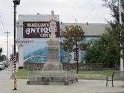
Cnr Queen Victoria St & Harvest Rd North Fremantle
Fallen Soldier's Memorial, North Fremantle
Fremantle
Metropolitan
Constructed from 1923
| Type | Status | Date | Documents |
|---|---|---|---|
| Heritage List | YES | 08 Mar 2007 | |
| State Register | Registered | 16 Nov 1993 | HCWebsite.Listing+ListingDocument |
| Type | Status | Date | Documents |
|---|---|---|---|
| (no listings) |
| Type | Status | Date | Grading/Management | |
|---|---|---|---|---|
| Category | ||||
| Municipal Inventory | Adopted | 18 Sep 2000 | Level 1A | |
| Register of the National Estate | Permanent | 28 Sep 1982 | ||
| Classified by the National Trust | Classified | 03 Nov 1980 | ||
| Statewide War Memorial Survey | Completed | 01 May 1996 | ||
03794 North Fremantle Town Centre Precinct
The granite base and railings were designed and çconstructed by G C Smith & Co, a family company çof monumental masons who still operate in çFremantle. The marble statue of the unknown çsoldier was imported from Italy. The cost of the çmonument was raised by public subscription from çwithin the North Fremantle municipality, a fact çthat older residents recall with pride.
| Name | Type | Year From | Year To |
|---|---|---|---|
| John McCabe, secretary of North Fremantle branch of RSL | Architect | - | - |
Individual Building or Group
| Epoch | General | Specific |
|---|---|---|
| Other Use | PARK\RESERVE | Park\Reserve |
| Present Use | MONUMENT\CEMETERY | Monument |
| Original Use | MONUMENT\CEMETERY | Monument\Cemetery |
| Original Use | MONUMENT\CEMETERY | Monument |
| Style |
|---|
| Other Style |
| Type | General | Specific |
|---|---|---|
| Other | STONE | Marble |
| Other | METAL | Cast Iron |
| Other | STONE | Granite |
| General | Specific |
|---|---|
| OUTSIDE INFLUENCES | World Wars & other wars |
This information is provided voluntarily as a public service. The information provided is made available in good faith and is derived from sources believed to be reliable and accurate. However, the information is provided solely on the basis that readers will be responsible for making their own assessment of the matters discussed herein and are advised to verify all relevant representations, statements and information.
Constructed from 1923
North Fremantle War Memorial has historic and social value to the North Fremantle community as a monument to the local men who lost their lives while serving overseas during World War One and Two. Funds for the memorial were raised by the local community, and the memorial itself was designed by the president of the North Fremantle branch of the RSL, Mr John McCabe. The monument documents the names of 105 men who died during World War One, the names of the 12 that lost their lives during the Second World War were added in 1945. The North Fremantle War Memorial has aesthetic value as a well-proportioned and executed combination of obelisk and statuary. Specifically located at a prominent intersection, the memorial has landmark value and serves as a reminder of the losses of war. The statue of a soldier is somewhat unusual for local monuments of this type, which are typically an obelisk, cairn or cross. The Municipal Gardens provide an appropriate setting for the memorial and together, the gardens and memorial contribute to the community’s sense of place.
The North Fremantle War Memorial is sited at the corner of Harvest Road and Victoria Street, North Fremantle, on a triangular piece of land adjacent to the former North Fremantle Town Hall. A flag pole stands to the north east of the memorial. The North Fremantle War Memorial consists of a granite pillar surmounted by a finely detailed statue of imported marble. The statue is of a First World War Australian infantry-man in the "rest on arms reversed" position. The pillar is inscribed with the names of those citizens of North Fremantle who gave their lives in the First World War and, later, in the Second World War. The granite base and railings were designed and constructed by G. C. Smith & Co., a family company of monumental masons. The marble statue of the unknown soldier was executed in Italy. The North Fremantle Memorial is approximately six metres in height. A two metre square base of rusticated grey granite supports an ornamental slab and a further rusticated base with polished inserts inscribed with the names of the fallen. Above this stands a highly polished obelisk of Mundaring granite, inscribed with the names of those who enlisted from the district.The obelisk is surmounted by a white marble statue of a soldier, in the "rest on arms reversed" position. The soldier faces southwards, down Queen Victoria Street. A decorative cast iron railing surrounds the whole. The area immediately surrounding the memorial is now paved with concrete slabs, although it is more likely to have been originally surrounded by a gravelled or grassed area. Additional names were added to the memorial to commemorate the dead service personnel of World War Two.
Australia sent numerous contingents of voluntary servicemen to battlefronts during World War One. The death toll of fighting Australians was high and the loss of life affected many communities quite deeply. Following the declaration of armistice, local communities throughout Australia raised money for the erection of memorials to commemorate members of their local community who lost their lives in the war. In this way, war memorials played an important role in both local recognition of the community’s losses and were a substitute gravesite for those who had died and were buried or missing overseas. About 550 men out of population of 4,000 from North Fremantle served overseas during World War One. Just over 100 did not return and in 1921, a committee was organised to raise funds for a memorial to these men. Funds for a memorial were to be raised by public subscription and the committee organised a variety of events, including bazaars, euchre parties, concerts, plays and door-to-door collections. Mr John McCabe, secretary to the memorial appeal committee and secretary of the North Fremantle branch of the RSL, submitted the design chosen for North Fremantle’s ‘Fallen Soldiers’ Memorial’. The Governor, Sir Francis Newdegate, laid the foundation stone on Sunday, 1 January 1923. The ceremony was attended by a large crowd, including Major General Sir John Talbot Hobbs. The site on the corner of the reserve next to the Town Hall was chosen as it would be seen by everyone that passed through the town. [John McCabe was Mayor of North Fremantle from 1924 to 1931.] G C Smith and Co, a local monumental masonry firm, made the Mundaring granite base and railings. The marble figure of an unknown soldier was imported from Italy. Governor Newdegate unveiled the monument on 26 August 1923. The ceremony was attended by hundreds of people, including the mayors of North and East Fremantle municipalities, Major General Sir John Talbot Hobbs, Commander Griffiths-Bowen, representatives of the army and navy, local politicians and policemen. After the Bishop of Perth, Reverend C L Riley, dedicated the memorial, over 40 wreaths were laid to commemorate those who lost their lives during the war. After the ceremony, the Governor met with relatives in the adjacent North Fremantle Town Hall. A total of 105 names were inscribed on each of the monuments four faces. In 1945, 12 names were added to commemorate those from the local community who died during World War Two. The gardens around the memorial have been maintained as an appropriate setting and the place has been a focal point for Anzac and Armistice day memorial services since its completion in 1923. In 1988, the Memorial was vandalised and the rifle damaged. The statue was restored and a new gun provided through the cooperative efforts of the City of Fremantle and the North Fremantle Community Association. The rifle was again stolen and replaced in 1995. This place was included in the 'North Fremantle Heritage Study' (1994) as a place contributing to the development and heritage of North Fremantle.
High degree of integrity High degree of authenticity (These statements based on street survey only).
Condition assessed as good (assessed from streetscape survey only).
| Name | Type | Year From | Year To |
|---|---|---|---|
| John McCabe, secretary of North Fremantle branch of RSL | Architect | - | - |
This information is provided voluntarily as a public service. The information provided is made available in good faith and is derived from sources believed to be reliable and accurate. However, the information is provided solely on the basis that readers will be responsible for making their own assessment of the matters discussed herein and are advised to verify all relevant representations, statements and information.
The memorial is a representative monument, of social and environmental significance.
The War Memorial at North Fremantle was erected in 1923 in commemoration of the citizens of the district who had lost their lives in the first world war. An additional roll was attached in 1945. The granite base and railings were designed and constructed by G C Smith & Co. a family company of Monumental Masons who still operate in Fremantle. The marble statue of the unknown soldier was imported from Italy. The cost of the monument was raised by subscription within the Municipality of North Fremantle, a fact that older residents recall with great pride.
Assessment 1980
This information is provided voluntarily as a public service. The information provided is made available in good faith and is derived from sources believed to be reliable and accurate. However, the information is provided solely on the basis that readers will be responsible for making their own assessment of the matters discussed herein and are advised to verify all relevant representations, statements and information.
261A Queen Victoria St & Jackson St & Jewell Pde North Fremantle
Fremantle
Metropolitan
| Type | Status | Date | Documents |
|---|---|---|---|
| Heritage List | YES | 08 Mar 2007 |
| Type | Status | Date | Documents |
|---|---|---|---|
| RHP - To be assessed | Current | 25 Jan 2006 |
| Type | Status | Date | Grading/Management | |
|---|---|---|---|---|
| Category | ||||
| Municipal Inventory | Adopted | 18 Sep 2000 | Level 2 | |
03794 North Fremantle Town Centre Precinct
| Library Id | Title | Medium | Year Of Publication |
|---|---|---|---|
| 9948 | Brian Klopper: Architectural projects. | Book | 2012 |
Individual Building or Group
| Epoch | General | Specific |
|---|---|---|
| Other Use | RELIGIOUS | Church Hall |
| Original Use | RELIGIOUS | Church, Cathedral or Chapel |
| Present Use | RESIDENTIAL | Other |
| Style |
|---|
| Federation Gothic |
| Type | General | Specific |
|---|---|---|
| Wall | STONE | Limestone |
| Wall | BRICK | Rendered Brick |
| Roof | METAL | Corrugated Iron |
| General | Specific |
|---|---|
| SOCIAL & CIVIC ACTIVITIES | Religion |
| DEMOGRAPHIC SETTLEMENT & MOBILITY | Land allocation & subdivision |
This information is provided voluntarily as a public service. The information provided is made available in good faith and is derived from sources believed to be reliable and accurate. However, the information is provided solely on the basis that readers will be responsible for making their own assessment of the matters discussed herein and are advised to verify all relevant representations, statements and information.
Constructed from 1895, Constructed from 1904
Former St Mary's Church and Church Hall are a typical stone and iron church building and a weatherboard and iron church hall building dating from the turn of the twentieth century. The place has aesthetic value for its contribution to the streetscape and the surrounding area. It is representative of turn of the Century stone churches located within Fremantle. The place is a example of the Federation Gothic style of architecture. Historically significant as the Church of England's first church in the North Fremantle area, built before the formation of the North Fremantle parish. The Church's need to build a church and hall in the area reflects the residential character of North Fremantle at the time.
Former St Mary's Church and Church Hall are a stone and iron former church building and a weatherboard and iron former church hall building designed in the Federation Gothic style of architecture. The Church building has been altered for use as a single residence. The alterations have included a kitchen and bathroom added in 1980, single storey additions to the front and rear of the building and internal modifications. In 1980, four new attached, three storey units were constructed. The units are orientated across the building and face towards Queen Victoria Street. These units are used for rental accommodation. In 1991, an office was added to the building and in recent years another three storey building has been constructed facing Jackson Street. The Church building was designed in the gothic revival style. Apart from subsequent brick additions, the construction comprises walls of squared limestone with rendered architraves to the lancet shaped windows. The windows were originally lead-light rough cast glass throughout. The northern windows were changed to coloured, figured glass in steel frames c1950. The roof was originally sheoak shingles on ship lapped boards on exposed rafters on underpurlins on scissor type trusses all in hand planed jarrah. Galvanised iron roof sheets were laid over shingles c1930s. A zincalume custom orb re-roof was carried out in 1988. This place contains a limestone feature - front limestone wall facing Jackson Street.
Jackson Street was originally part of Lot P47, which was granted to Pensioner Guard George Costigan in 1884. The land was transferred to James Roe (Perth Journalist), then to George Frederick Gallop (Fremantle Clerk) before being purchased by a group of gentlemen in 1897. William Edward Marmion, James Grave, Edward Keane, Edmund Gilyard Lacey and Frederick Charles Monger immediately subdivided the land for residential development and the lots were gradually taken up between 1897 and 1913. The origin of the name Jackson Street is not known. Jackson Street was developed as a short street running east-west between Pearse Street and Queen Victoria Street (near the present junction with Stirling Highway). The houses built in Jackson Street were generally modest brick, stone or timber cottages for people working in the area. Many of the houses were investment properties leased to tenants. With the development and expansion of Fremantle Port, the zoning for the area changed from residential to general industrial purposes. In 2004, Jackson Street continues to be a residential street with most homes occupied by their owners. The Anglican Church of St Mary the Virgin was built in 1895 for the growing North Fremantle community. Prior to the construction of their own church, the Anglican community of North Fremantle are believed to have held services in a building known as ‘The Depot’ (located northwest of the former North Fremantle State School). By 1889, services were held in the ‘New Mission Hall’ (later called the ‘St John’s Mission Hall’ or ‘Mason’s Hall’) in John Street. Reverend Canon Watkins served as Rector for north ward of the Fremantle Parish and when the North Fremantle municipality was declared in 1895, the Church of England began plans to build a church in the area. On 20 March 1895, Bishop C O L Riley laid the foundation stone for St Mary’s. A copy of the West Australian and a number of coins were placed in the foundation stone. The building initially comprised a simple rectangle, as the Sanctuary and the dressing of the internal walls were completed at a later date. The Rector of St John’s continued to be responsible for services with assistance from lay readers until the formation of the North Fremantle parish in 1899. The first Rector at North Fremantle was Reverend W F Marshall. A Rectory was built at 13 Jackson Street in 1899. In 1901, it was estimated that of North Fremantle’s population of 3,281, approximately 1,000 were Church of England. The weatherboard and iron Church Hall, or Guild Hall, on the site faces Jewell Parade, was built in 1904 for the use of the parishioners and community of St Mary’s Church. Biship Riley laid a tablet on 9 November 1904 to mark the opening. Prior to the construction of the hall, the parish community used Albert Hall in Jewell Parade for social functions. The Church Hall was used for Sunday School, Mother’s Union, Girls’ Friendly Society, Gymnasium Club, Junior cricket club, a Glee club, and Musical Evenings with the church choir. With the onset of World War One, more industries began to establish in the North Fremantle area and the North Fremantle parish continued to attract a steady flow of parishioners until the early 1940s, by which time the area had become dominated by industry. St Mary’s ceased to have a resident rector in 1942, and rectors from East Fremantle or Fremantle oversaw St Mary’s. Recognising the residential decline of the area, the Church of England notified the City of Fremantle that St Mary’s would no longer be used for religious services in the early 1970s. The Church’s requested that the zoning of the land be changed to commercial or light industrial was granted in 1972, the same year that the grounds were deconsecrated. The Church building remained vacant until the following year when it was occupied by the Fremantle Community School. The following information was provided by Robert (Bob) Gare: Between 1974 and 1977, the building was occupied by AC Display services. In 1976 with zoning changed to residential the building was transferred to Gare and Klopper Architects and was rented to the Gare family. The Gare family subsequently became owners/occupiers in June 1979. Bob Gare as Architect and ‘hands on builder’ commenced redevelopment of the whole site while with wife Kate and four children initially camped in the empty church building using outside public toilet and hall supper room as makeshift bathroom. Firstly, by the end of 1979, four three storey rental town house units were built on the portion of land facing Queen Victoria Street. Internal work then began on the Church building to make it more appropriate as a residence, including two mezzanine floors for bedrooms and installation of kitchen and two bathrooms. Cyclone Alby exposed serious structural instability of a swaying hall building and moving and cracking north wall of the church building. For the Hall to be approved as a residence the stage and supper room part of the building had to be demolished as these encroached on Jack ST and a masonry firewall was required on the southern side. Mezzanine floors at each end together with steel bracing at one and rear brick bathroom, kitchen at the other end stabilized the dilapidated structure. Jeremy and Megan Kirwan-Ward were invited to occupy the building while this work was done. They became owners in 1986. As interim measure to improve the Church north wall was to connect it by ‘S’ brackets to the internal timber construction. The final solution in 1990 was to introduce two flying buttresses mid wall between end piers. These were incorporated in creating additions, originally intended for architects' office but instead became a granny flat for Grandmother Gare until 2002. At one time during this period one townhouse, church and granny flat housed four generations of the Gare family. While being primarily used as a residence, the Church building retains its original social character. It has provided a venue for large Christmas carol gathers and weddings for family and friends. Other activities have included architect/builder office, management and practice for family bands Bungarra, Jam Tarts, Nansing, art exhibitions and a television studio for ‘The Best’ TV Series. In 2001, to complete the redevelopment, ‘Anna Gare Catering’ was provided with a three storey commercial kitchen building facing Jackson St. That tenancy ceased in 2011. In 2013 the Church and Church hall remain residences with Gare and Kirwan-Ward owner occupiers respectively. The four townhouses remain rental. The kitchen building is rented to ‘Rawsome’ raw food caterers. This place was included in the 'North Fremantle Heritage Study' (1994) as a place contributing to the development and heritage of North Fremantle. It was also included in the list of heritage places in the City of Fremantle identified by the Fremantle Society (1979/80) - PURPLE -of architectural and historic significance in its own right.
Moderate to low degree of integrity (externally original intent clear, current use moderately compatible, high long term sustainability, partially restored, some loss of fabric and significant internal alterations). Moderate degree of authenticity with basic original fabric remaining.Some loss of fabric and introduction of new fabric. (These statements based on street survey only).
Condition assessed as fair to good (assessed from streetscape survey only).
This information is provided voluntarily as a public service. The information provided is made available in good faith and is derived from sources believed to be reliable and accurate. However, the information is provided solely on the basis that readers will be responsible for making their own assessment of the matters discussed herein and are advised to verify all relevant representations, statements and information.
Rocky Bay North Fremantle
Fremantle
Metropolitan
| Type | Status | Date | Documents |
|---|---|---|---|
| Heritage List | YES | 08 Mar 2007 |
| Type | Status | Date | Documents |
|---|---|---|---|
| (no listings) |
| Type | Status | Date | Grading/Management | |
|---|---|---|---|---|
| Category | ||||
| Municipal Inventory | Adopted | 18 Sep 2000 | Level 3 | |
Landscape
| Epoch | General | Specific |
|---|---|---|
| Present Use | PARK\RESERVE | Park\Reserve |
| Original Use | PARK\RESERVE | Park\Reserve |
| General | Specific |
|---|---|
| SOCIAL & CIVIC ACTIVITIES | Environmental awareness |
This information is provided voluntarily as a public service. The information provided is made available in good faith and is derived from sources believed to be reliable and accurate. However, the information is provided solely on the basis that readers will be responsible for making their own assessment of the matters discussed herein and are advised to verify all relevant representations, statements and information.
Constructed from 1982
22385 North Fremantle Precinct
Burford Road Park has aesthetic value for its contribution to the surrounding area. It also has historical significance for its associations with the former Burford Soap Factory.
Burford Road Park is a small grassed corner site with timber bollards along the perimeter. Small trees dotted throughout the park. There is some children's play equipment.
Burford Road Park was vested in City of Fremantle 1982 (Reserve 37358 and Reserve 37359). The park is located above the Burford Soap Factory tunnel, which is visible in the cliffs and is an important area of open space for the community near the Rocky Bay foreshore. [See entry for Burfords Soap Factory, 51 Rule Street for further information.] This place was included in the "North Fremantle Heritage Study", prepared by Craig Burton, for the City of Fremantle, June 1994. This place has been identified in 'Fremantle's Landscape: A Study for the Municipal Inventory' as being of cultural heritage significance'.
High degree of integrity (original intent clear, current use compatible, high long term sustainability). High degree of authenticity with much original fabric remaining. (These statements based on street survey only).
Condition assessed as good (assessed from streetscape survey only).
This information is provided voluntarily as a public service. The information provided is made available in good faith and is derived from sources believed to be reliable and accurate. However, the information is provided solely on the basis that readers will be responsible for making their own assessment of the matters discussed herein and are advised to verify all relevant representations, statements and information.
Rocky Bay Reserve North Fremantle
Fremantle
Metropolitan
| Type | Status | Date | Documents |
|---|---|---|---|
| Heritage List | YES | 08 Mar 2007 |
| Type | Status | Date | Documents |
|---|---|---|---|
| (no listings) |
| Type | Status | Date | Grading/Management | |
|---|---|---|---|---|
| Category | ||||
| Municipal Inventory | Adopted | 18 Sep 2000 | Level 2 | |
Landscape
| Epoch | General | Specific |
|---|---|---|
| Original Use | OTHER | Other |
| General | Specific |
|---|---|
| DEMOGRAPHIC SETTLEMENT & MOBILITY | Environmental change |
| PEOPLE | Aboriginal people |
| DEMOGRAPHIC SETTLEMENT & MOBILITY | Land allocation & subdivision |
This information is provided voluntarily as a public service. The information provided is made available in good faith and is derived from sources believed to be reliable and accurate. However, the information is provided solely on the basis that readers will be responsible for making their own assessment of the matters discussed herein and are advised to verify all relevant representations, statements and information.
Constructed from 1901
22385 North Fremantle Precinct
This area is highly significant for botanical, historical and social reasons. It is regarded as one of three only sites in the City of Fremantle to contain remnant vegetation reminiscent of the years before 1829. Stone quarried above these cliffs and to their north was transported by rail to build the north mole of the inner harbour. The Burford soap works ran a tunnel through the cliffs to drain their effluent into the Swan River. This tunnel is still visible and is evidence of former occupations and use of the environment.
A rocky foreshore environment. Limestone cliff faces, grassed areas, naturally vegetated areas. Contains some seating and table facilities.
Cypress Hill has significant associations for local Nyungar people. The Rocky Bay cave under the hill is where the Waugal (rainbow serpent) rested on its journey home upriver, curling itself around the central pillar. The reserve was vested in the Fremantle Council in 1901 [reserve 7077]. Cypress Hill is the highest point in North Fremantle and was a popular picnic spot and vantage point, giving good views to the east and west. In 1907, the Morning Herald described Cypress Hill as ‘... another popular resort, and from this also a good view may be obtained’. During World War Two, anti-aircraft guns were installed on the top of the hill. It is likely that they were dug into the flat circular clearing on the hill’s top. From the 1890s to 1914, T H Briggs and Co. operated a lime burning and quarrying company in the area between Mosman Park and North Fremantle and used the cave to burn their lime. The natural chimney of the cave was squared out at this time, probably so that materials could be hoisted up and down by a headgear on the top. The hill was also the site of annual bon fire nights (the time of this is not known). Local children would make big bonfires on top of the hill and light it up on Guy Fawke’s night. According to reminiscences, children from other suburbs would sometimes sneak in and light the bonfire early, much to the disgust of local children. Community action in the 1980s and 1990s preserved the remaining vegetation and provided an access track around the cliffs. It is thus evidence of the important of community interest in landscape. This place has been identified in 'Fremantle's Landscape: A Study for the Municipal Inventory' as being of cultural heritage significance'. The place is identified in the North Fremantle Heritage Study (1994) as being of cultural heritage significance to the development of the State of Western Australia.
Medium degree of integrity (original intent clear, current use compatible, high long term sustainability, some later unsympathetic materials). Medium degree of authenticity with some loss of original fabric. (These statements based on street survey only).
Condition assessed as fair (assessed from streetscape survey only).
This information is provided voluntarily as a public service. The information provided is made available in good faith and is derived from sources believed to be reliable and accurate. However, the information is provided solely on the basis that readers will be responsible for making their own assessment of the matters discussed herein and are advised to verify all relevant representations, statements and information.