Local Government
Fremantle
Region
Metropolitan
17 Harvest Rd North Fremantle
Fremantle
Metropolitan
| Type | Status | Date | Documents |
|---|---|---|---|
| (no listings) |
| Type | Status | Date | Documents |
|---|---|---|---|
| (no listings) |
| Type | Status | Date | Grading/Management | |
|---|---|---|---|---|
| Category | ||||
| Municipal Inventory | Adopted | 18 Sep 2000 | Level 3 | |
Individual Building or Group
| Epoch | General | Specific |
|---|---|---|
| Present Use | RESIDENTIAL | Single storey residence |
| Original Use | RESIDENTIAL | Single storey residence |
| Style |
|---|
| Federation Bungalow |
| Type | General | Specific |
|---|---|---|
| Wall | STONE | Limestone |
| Wall | BRICK | Rendered Brick |
| Roof | TILE | Terracotta Tile |
| General | Specific |
|---|---|
| DEMOGRAPHIC SETTLEMENT & MOBILITY | Land allocation & subdivision |
This information is provided voluntarily as a public service. The information provided is made available in good faith and is derived from sources believed to be reliable and accurate. However, the information is provided solely on the basis that readers will be responsible for making their own assessment of the matters discussed herein and are advised to verify all relevant representations, statements and information.
Constructed from 1940
22385 North Fremantle Precinct
House and Limestone Feature, 17 Harvest Road, is a typical rendered brick and tile single storey house dating from the 1940s. The place has aesthetic value for its contribution to the streetscape and the surrounding area. It is representative of the typical building stock located within the residential areas of North Fremantle. Historically significant as a representation of typical workers' houses in the North Fremantle area. The place is an example of the Federation Bungalow style of architecture.
House and Limestone Feature, 17 Harvest Road, is a rendered brick and tile single storey house built in the Federation Bungalow style of architecture. The façade is asymmetrical. The walls are rendered brick above a high limestone foundation. The roof is tiled with a long low gable to the front elevation. This gable end has roughcast render and timber paneling typical to the style. The verandah is deep and under the main roof gable with rendered columns and a rendered masonry balustrade. There is a high level rendered brick fence to the front boundary line. This site contains a limestone feature - limestone foundations to house.
From the nineteenth century, Harvest Road was important as an access route to Point Direction, the location of a sheltered landing place. Boat building yards were located at Point Direction for much of the twentieth century, during which time the Harvest Road jetty also became a popular family swimming and picnic area. Originally, Harvest Road began at Stirling Highway (then called Bruce Street), but from 1899 it was extended through to Queen Victoria Street (then called Victoria Street). Harvest Road has always been a predominantly residential street, developing steadily from the turn of the twentieth century, and characterised at least in its early decades as a place with a large number of rental properties. Three industries on the street were Purina (1935-55) and Nabisco (1955-88) cereal manufacturers (number 3-5), Rowlands Co Cordial, Wine and Spirits manufacturers (1908 to at least 1939, at number 11), and various marine industries, most prominently Browns Boat Building Yard (from c.1900), which was located between Corkhill (Elizabeth) Street and the River. The brick residence at 17 Harvest Road appears on the 1939 sewerage plan, sited close to the road. The residence was constructed between 1936 and 1941. This place was identified in the "Heritage Report on 19th century limestone walls and steps in Fremantle" prepared by Silvana Grassadonia, for the City of Fremantle, 1986.
High degree of integrity (original intent clear, current use compatible, high long term sustainability, restored). High degree of authenticity with much original fabric remaining. (These statements based on street survey only).
Condition assessed as good (assessed from streetscape survey only).
This information is provided voluntarily as a public service. The information provided is made available in good faith and is derived from sources believed to be reliable and accurate. However, the information is provided solely on the basis that readers will be responsible for making their own assessment of the matters discussed herein and are advised to verify all relevant representations, statements and information.
18 Harvest Rd North Fremantle
Fremantle
Metropolitan
| Type | Status | Date | Documents |
|---|---|---|---|
| Heritage List | YES | 08 Mar 2007 |
| Type | Status | Date | Documents |
|---|---|---|---|
| (no listings) |
| Type | Status | Date | Grading/Management | |
|---|---|---|---|---|
| Category | ||||
| Municipal Inventory | Adopted | 18 Sep 2000 | Level 3 | |
Individual Building or Group
| Epoch | General | Specific |
|---|---|---|
| Original Use | RESIDENTIAL | Conjoined residence |
| Present Use | RESIDENTIAL | Conjoined residence |
| Style |
|---|
| Victorian Georgian |
| Type | General | Specific |
|---|---|---|
| Wall | BRICK | Face Brick |
| Wall | STONE | Limestone |
| Wall | RENDER | Smooth |
| Roof | METAL | Corrugated Iron |
| General | Specific |
|---|---|
| DEMOGRAPHIC SETTLEMENT & MOBILITY | Land allocation & subdivision |
This information is provided voluntarily as a public service. The information provided is made available in good faith and is derived from sources believed to be reliable and accurate. However, the information is provided solely on the basis that readers will be responsible for making their own assessment of the matters discussed herein and are advised to verify all relevant representations, statements and information.
Constructed from 1903
22385 North Fremantle Precinct
Duplex, 18-20 Harvest Road, a typical limestone and iron single storey cottage duplex dating from the 1900s has cultural heritage significance for the following reasons: the place has aesthetic value as a simple example of the Victorian Georgian style of architecture and for its contribution to the streetscape and the surrounding area; it is representative of the typical building stock located within the residential areas of North Fremantle the place has some historic as a representation of typical workers' houses in the North Fremantle area: and, it is representative of the typical workers' houses in the North Fremantle area.
Duplex, 18-20 Harvest Road is a single storey stone and iron duplex with overall symmetrical facade designed as a late example of the Victorian Georgian style of architecture. The limestone walls have brick quoins and reveals. The roof is hipped and clad with corrugated iron with no eaves and there is a dividing parapet wall. The verandahs are under a separate corrugated iron roof and are supported by steel posts. Front elevation is symmetrical with a timber framed sash window and a front door to each side. The duplex is set at an angle to the street. Number 20 has a high front wall and substantial two storey additions at the rear. A Heritage Assessment was prepared in Nov 2009 by the City of Fremantle for a DA submission to Council for proposed single storey additions and alterations to No 18.
From the nineteenth century, Harvest Road was important as an access route to Point Direction, the location of a sheltered landing place. Boat building yards were located at Point Direction for much of the twentieth century, during which time the Harvest Road jetty also became a popular family swimming and picnic area. Originally, Harvest Road began at Stirling Highway (then called Bruce Street), but from 1899 it was extended through to Queen Victoria Street (then called Victoria Street). Harvest Road has always been a predominantly residential street, developing steadily from the turn of the twentieth century, and characterised at least in its early decades as a place with a large number of rental properties. Three industries on the street were Purina (1935-55) and Nabisco (1955-88) cereal manufacturers (number 3-5), Rowlands Co Cordial, Wine and Spirits manufacturers (1908 to at least 1939, at number 11), and various marine industries, most prominently Browns Boat Building Yard (from c.1900), which was located between Corkhill (Elizabeth) Street and the River. Duplex, 18-20 Harvest Road was constructed in 1903. The first resident of the duplex was T.A Bastian, at 20, and 18 was first occupied by Bert Pick, the Fremantle Postmaster. However, by 1907 occupancy changed to George Sutton (18) and C.J Salier (20), and for at least the next twenty years occupancy changed every year or two, suggesting the duplex was used as rental accommodation through this period. This place was included in the 'North Fremantle Heritage Study' (1994) as a place contributing to the development and heritage of North Fremantle. It was also included in the list of heritage places in the City of Fremantle identified by the Fremantle Society (1979/80) - BROWN -significant for making a positive contribution to the built environment of Fremantle. A Heritage Assessment was prepared in Nov 2009 by the City of Fremantle for a DA submission to Council for proposed single storey additions and alterations to No 18.
Duplex, 18 Harvest Road has a moderate to high degree of integrity (original intent clear, current use compatible, high long term sustainability, partially restored, some loss of fabric and previous unsympathetic alterations). Moderate degree of authenticity with basic original fabric remaining.Some loss of fabric. (These statements based on street survey only). Duplex, 20 Harvest Road has a high degree of integrity (original intent clear, current use compatible, high long term sustainability, partially restored). High degree of authenticity with most original fabric remaining (These statements based on street survey only).
Condition of number 18 is assessed as fair to good.Condition of number 20 is assessed as fair to good (assessed from streetscape survey only).
This information is provided voluntarily as a public service. The information provided is made available in good faith and is derived from sources believed to be reliable and accurate. However, the information is provided solely on the basis that readers will be responsible for making their own assessment of the matters discussed herein and are advised to verify all relevant representations, statements and information.
19 Harvest Rd North Fremantle
Formerly listed House, Limestone Feature(s) & Tree Grove, 19 Harvest Road
Fremantle
Metropolitan
| Type | Status | Date | Documents |
|---|---|---|---|
| Heritage List | YES | 08 Mar 2007 |
| Type | Status | Date | Documents |
|---|---|---|---|
| (no listings) |
| Type | Status | Date | Grading/Management | |
|---|---|---|---|---|
| Category | ||||
| Municipal Inventory | Adopted | 18 Sep 2000 | Level 3 | |
Individual Building or Group
| Epoch | General | Specific |
|---|---|---|
| Present Use | RESIDENTIAL | Single storey residence |
| Original Use | RESIDENTIAL | Single storey residence |
| Style |
|---|
| Federation Bungalow |
| Type | General | Specific |
|---|---|---|
| Roof | TILE | Terracotta Tile |
| Wall | STONE | Limestone |
| Wall | BRICK | Rendered Brick |
| General | Specific |
|---|---|
| DEMOGRAPHIC SETTLEMENT & MOBILITY | Land allocation & subdivision |
This information is provided voluntarily as a public service. The information provided is made available in good faith and is derived from sources believed to be reliable and accurate. However, the information is provided solely on the basis that readers will be responsible for making their own assessment of the matters discussed herein and are advised to verify all relevant representations, statements and information.
Constructed from 1910
22385 North Fremantle Precinct
House, Limestone Feature and Tree Grove 19 Harvest Road, is a typical rendered brick and tile single storey house dating from the 1940s. The place has aesthetic value for its contribution to the streetscape and the surrounding area. It is representative of the typical building stock located within the residential areas of North Fremantle. Historically significant as a representation of typical workers' houses in the North Fremantle area. The place is an example of the Federation Bungalow style of architecture.
House, 19 Harvest Road is a single storey limestone, rendered brick and tile house with asymmetrical facade designed as an example of the Federation Bungalow style of architecture. Walls are rendered brick sitting on a high limestone foundation. Roof is tiled with a long low gable to the front elevation. This gable end has roughcast render and timber paneling typical to the style. The verandah is deeply recessed under the main roof gable. A second gable has open vents, and the window has a tiled awning over. The side elevation is face brick. The verandah is supported by rendered columns and a rendered balustrade. There is a triple set of timber framed casement windows under the verandah to the front elevation. There is a low level brick fence to the front boundary line. This site contains a limestone feature - This feature is the limestone foundations to the house. This site contains a mature grove of trees of melaleuca lancelota and eucalyptus gomphocephala. These trees were probably planted after the Second World War.
From the nineteenth century, Harvest Road was important as an access route to Point Direction, the location of a sheltered landing place. Boat building yards were located at Point Direction for much of the twentieth century, during which time the Harvest Road jetty also became a popular family swimming and picnic area. Originally, Harvest Road began at Stirling Highway (then called Bruce Street), but from 1899 it was extended through to Queen Victoria Street (then called Victoria Street). Harvest Road has always been a predominantly residential street, developing steadily from the turn of the twentieth century, and characterised at least in its early decades as a place with a large number of rental properties. Three industries on the street were Purina (1935-55) and Nabisco (1955-88) cereal manufacturers (number 3-5), Rowlands Co Cordial, Wine and Spirits manufacturers (1908 to at least 1939, at number 11), and various marine industries, most prominently Browns Boat Building Yard (from c.1900), which was located between Corkhill (Elizabeth) Street and the River. A house was constructed at 19 Harvest Road in c.1910 and occupied by John Symington until 1913. After a brief occupancy by Thomas Johnson, Charles Posselt arrived in 1915 and resided at the place until 1916, followed by Kaitain Posselt to 1919. Charles Posselt had been living further along Harvest Road at 27, and possibly also 29, from 1905. From 1922 until at least 1925, the place was occupied by Mrs M.J. Bolton. Photographs dated c.1929 show a stone and iron residence with brick quoining, a skillion verandah with timber lattice, and is noted as being the Vickridge family residence. This place was identified in the "Heritage Report on 19th century limestone walls and steps in Fremantle" prepared by Silvana Grassadonia, for the City of Fremantle, 1986. It contains a limestone feature - the limestone foundations to the house. The site also includes a tree grove of melaleuca lancelota and eucalyptus gomphocephala. These trees were probably planted after the Second World War. On the 27 February 2019 the City of Fremantle’s Council adopted the Register of Significant Trees and Vegetated Areas and determined that the Tree Grove be removed from the Heritage List and added to the new Significant Tree Register.
High degree of integrity (original intent clear, current use compatible, high long term sustainability, restored). High degree of authenticity with much original fabric remaining. (These statements based on street survey only).
Condition assessed as good (assessed from streetscape survey only).
This information is provided voluntarily as a public service. The information provided is made available in good faith and is derived from sources believed to be reliable and accurate. However, the information is provided solely on the basis that readers will be responsible for making their own assessment of the matters discussed herein and are advised to verify all relevant representations, statements and information.
20 Harvest Rd North Fremantle
Fremantle
Metropolitan
| Type | Status | Date | Documents |
|---|---|---|---|
| Heritage List | YES | 08 Mar 2007 |
| Type | Status | Date | Documents |
|---|---|---|---|
| (no listings) |
| Type | Status | Date | Grading/Management | |
|---|---|---|---|---|
| Category | ||||
| Municipal Inventory | Adopted | 18 Sep 2000 | Level 3 | |
Individual Building or Group
| Epoch | General | Specific |
|---|---|---|
| Present Use | RESIDENTIAL | Conjoined residence |
| Original Use | RESIDENTIAL | Conjoined residence |
| Style |
|---|
| Victorian Georgian |
| Type | General | Specific |
|---|---|---|
| Wall | BRICK | Face Brick |
| Wall | STONE | Limestone |
| Roof | METAL | Corrugated Iron |
| Wall | RENDER | Smooth |
| General | Specific |
|---|---|
| DEMOGRAPHIC SETTLEMENT & MOBILITY | Land allocation & subdivision |
This information is provided voluntarily as a public service. The information provided is made available in good faith and is derived from sources believed to be reliable and accurate. However, the information is provided solely on the basis that readers will be responsible for making their own assessment of the matters discussed herein and are advised to verify all relevant representations, statements and information.
Constructed from 1903
22385 North Fremantle Precinct
Duplex, 18-20 Harvest Road, a typical limestone and iron single storey cottage duplex dating from the 1900s has cultural heritage significance for the following reasons: The place has aesthetic value as a simple example of the Victorian Georgian style of architecture and for its contribution to the streetscape and the surrounding area; it is representative of the typical building stock located within the residential areas of North Fremantle the place has some historic as a representation of typical workers' houses in the North Fremantle area: and, it is representative of the typical workers' houses in the North Fremantle area.
Duplex, 18-20 Harvest Road is a single storey stone and iron duplex with overall symmetrical facade designed as a late example of the Victorian Georgian style of architecture. The limestone walls have brick quoins and reveals. The roof is hipped and clad with corrugated iron with no eaves and there is a dividing parapet wall. The verandahs are under a separate corrugated iron roof and are supported by steel posts. Front elevation is symmetrical with a timber framed sash window and a front door to each side. The duplex is set at an angle to the street. Number 20 has a high front wall and substantial two storey additions at the rear. A Heritage Assessment was prepared in Nov 2009 by the City of Fremantle for a DA submission to Council for proposed single storey additions and alterations to No 18.
From the nineteenth century, Harvest Road was important as an access route to Point Direction, the location of a sheltered landing place. Boat building yards were located at Point Direction for much of the twentieth century, during which time the Harvest Road jetty also became a popular family swimming and picnic area. Originally, Harvest Road began at Stirling Highway (then called Bruce Street), but from 1899 it was extended through to Queen Victoria Street (then called Victoria Street). Harvest Road has always been a predominantly residential street, developing steadily from the turn of the twentieth century, and characterised at least in its early decades as a place with a large number of rental properties. Three industries on the street were Purina (1935-55) and Nabisco (1955-88) cereal manufacturers (number 3-5), Rowlands Co Cordial, Wine and Spirits manufacturers (1908 to at least 1939, at number 11), and various marine industries, most prominently Browns Boat Building Yard (from c.1900), which was located between Corkhill (Elizabeth) Street and the River. Duplex, 18-20 Harvest Road was constructed in 1903. The first resident of the duplex was T.A Bastian, at 20, and 18 was first occupied by Bert Pick, the Fremantle Postmaster. However, by 1907 occupancy changed to George Sutton (18) and C.J Salier (20), and for at least the next twenty years occupancy changed every year or two, suggesting the duplex was used as rental accommodation through this period. This place was included in the 'North Fremantle Heritage Study' (1994) as a place contributing to the development and heritage of North Fremantle. It was also included in the list of heritage places in the City of Fremantle identified by the Fremantle Society (1979/80) - BROWN -significant for making a positive contribution to the built environment of Fremantle.
Duplex, 18 Harvest Road has a moderate to high degree of integrity (original intent clear, current use compatible, high long term sustainability, partially restored, some loss of fabric and previous unsympathetic alterations). Moderate degree of authenticity with basic original fabric remaining.Some loss of fabric. (These statements based on street survey only). Duplex, 20 Harvest Road has a high degree of integrity (original intent clear, current use compatible, high long term sustainability, partially restored). High degree of authenticity with most original fabric remaining (These statements based on street survey only).
Condition of number 18 is assessed as fair to good.Condition of number 20 is assessed as fair to good (assessed from streetscape survey only).
This information is provided voluntarily as a public service. The information provided is made available in good faith and is derived from sources believed to be reliable and accurate. However, the information is provided solely on the basis that readers will be responsible for making their own assessment of the matters discussed herein and are advised to verify all relevant representations, statements and information.
22 Harvest Rd North Fremantle
Fremantle
Metropolitan
| Type | Status | Date | Documents |
|---|---|---|---|
| Heritage List | YES | 08 Mar 2007 |
| Type | Status | Date | Documents |
|---|---|---|---|
| (no listings) |
| Type | Status | Date | Grading/Management | |
|---|---|---|---|---|
| Category | ||||
| Municipal Inventory | Adopted | 18 Sep 2000 | Level 3 | |
Individual Building or Group
| Epoch | General | Specific |
|---|---|---|
| Original Use | RESIDENTIAL | Conjoined residence |
| Present Use | RESIDENTIAL | Conjoined residence |
| Other Use | RESIDENTIAL | Two storey residence |
| Style |
|---|
| Victorian Georgian |
| Type | General | Specific |
|---|---|---|
| Roof | METAL | Corrugated Iron |
| Wall | BRICK | Common Brick |
| Wall | STONE | Limestone |
| General | Specific |
|---|---|
| DEMOGRAPHIC SETTLEMENT & MOBILITY | Land allocation & subdivision |
This information is provided voluntarily as a public service. The information provided is made available in good faith and is derived from sources believed to be reliable and accurate. However, the information is provided solely on the basis that readers will be responsible for making their own assessment of the matters discussed herein and are advised to verify all relevant representations, statements and information.
Constructed from 1913
22385 North Fremantle Precinct
Duplex, 22 Harvest Road, is a modified stone and iron single storey cottage duplex dating from the 1910s. Not withstanding the additions, the place has some aesthetic value for its contribution to the streetscape and the surrounding area. It is representative of the modified building stock located within the residential areas of North Fremantle.
Duplex, 22 Harvest Road was originally a single storey stone and iron duplex pair (with 24 Harvest Road) with overall symmetrical facade designed as a late example of the Victorian Georgian style of architecture. Number 24 still remains as a single storey duplex half with rendered limestone and rendered brick walls. Number 22 has had a second storey addition. There is a limestone dividing parapet wall. No 24 has a hipped corrugated iron roof with no eaves. The verandah to 24 is under a separate bull nosed corrugated iron roof supported by decorative timber posts with decorative timber frieze and brackets. The front elevation to 24 has a double hung sash timber window and a timber framed front door. No 22 has a new gabled corrugated iron roof and a bull nosed corrugated iron verandah. The front elevation to 22 has a double hung sash timber window and a timber framed front door to the lower level and a pair of timber framed double hung sash windows to the upper level. Rendered limestone foundations. There is a rendered brick wall to 24.
From the nineteenth century, Harvest Road was important as an access route to Point Direction, the location of a sheltered landing place. Boat building yards were located at Point Direction for much of the twentieth century, during which time the Harvest Road jetty also became a popular family swimming and picnic area. Originally, Harvest Road began at Stirling Highway (then called Bruce Street), but from 1899 it was extended through to Queen Victoria Street (then called Victoria Street). Harvest Road has always been a predominantly residential street, developing steadily from the turn of the twentieth century, and characterised at least in its early decades as a place with a large number of rental properties. Three industries on the street were Purina (1935-55) and Nabisco (1955-88) cereal manufacturers (number 3-5), Rowlands Co Cordial, Wine and Spirits manufacturers (1908 to at least 1939, at number 11), and various marine industries, most prominently Browns Boat Building Yard (from c.1900), which was located between Corkhill (Elizabeth) Street and the River. Duplex, 22-24 Harvest Road was constructed c.1913. Alfred E Westergaard resided at 24 Harvest Road until 1918. Occupants at 22 Harvest Road, and later also 24, changed frequently, suggesting the duplex was used as rental accommodation. From c.1920 Hugh Wauhop lived at 22 Harvest Road for several years. John Wauhop was also resident in the duplex in the early 1920s, although he appears to have moved between the houses at 22, 24 and 26. By the early 1990s, 22 Harvest Road was in disrepair, with a 1996 photograph showing the place having no roof and showing evidence of earlier fire damage. It was sold in 1996 as ‘three stone rooms (uninhabitable)’, and redeveloped through 1997 into a two-storey residence incorporating the surviving fabric of the original stone residence. 24 Harvest Road remains under separate ownership in 2004 as a single-storey stone cottage. This place was included in the 'North Fremantle Heritage Study' (1994) as a place contributing to the development and heritage of North Fremantle. It was also included in the list of heritage places in the City of Fremantle identified by the Fremantle Society (1979/80) - RED -significant for contributing to the unique character of Fremantle.
No 24 has a high degree of integrity (original intent clear, current use compatible, high long term sustainability, restored, some unsympathetic alterations such as rendered walls). High degree of authenticity with much original fabric remaining. (These statements based on street survey only). No 22 has a low to moderate degree of integrity (original intent unclear, current use compatible, high long term sustainability, restored, much loss of fabric and substantial additions). Low to Moderate degree of authenticity with some original fabric remaining. Much loss of fabric. (These statements based on street survey only).
Condition assessed as good (assessed from streetscape survey only).
This information is provided voluntarily as a public service. The information provided is made available in good faith and is derived from sources believed to be reliable and accurate. However, the information is provided solely on the basis that readers will be responsible for making their own assessment of the matters discussed herein and are advised to verify all relevant representations, statements and information.
23 Harvest Rd North Fremantle
Cnr Turton St
Hill Crest
Hillcrest Salvation Army Home
Hillcrest Senior Citizen's Residence
Maternity Hospital
Fremantle
Metropolitan
Constructed from 1901
| Type | Status | Date | Documents |
|---|---|---|---|
| Heritage Agreement | YES | 17 May 2016 | HCWebsite.Listing+ListingDocument |
| Heritage List | YES | 08 Mar 2007 | |
| State Register | Registered | 17 Mar 2006 | HCWebsite.Listing+ListingDocument, HCWebsite.Listing+ListingDocument |
| Type | Status | Date | Documents |
|---|---|---|---|
| (no listings) |
| Type | Status | Date | Grading/Management | |
|---|---|---|---|---|
| Category | ||||
| Register of the National Estate | Permanent | 28 Sep 1982 | ||
| Classified by the National Trust | Classified | 03 Nov 1980 | ||
| Municipal Inventory | Adopted | 18 Sep 2000 | Level 1A | |
09128 Harvest Road Precinct
Overall the place is in good condition.
| Library Id | Title | Medium | Year Of Publication |
|---|---|---|---|
| 11509 | Hillcrest | Heritage Study {Cons'n Plan} | 2016 |
| 7023 | Images CD No. 27 : assessment images : Hillcrest, Homeleigh, South Beach. | C D Rom | 2004 |
| 10239 | Hillcrest: Archival record | Archival Record | 2014 |
| 11508 | Hillcrest: conservation management plan | Heritage Study {Cons'n Plan} | 2013 |
| 11483 | Medical background: Being a history of Fremantle hospitals and doctors | Book | 1969 |
Individual Building or Group
| Epoch | General | Specific |
|---|---|---|
| Original Use | RESIDENTIAL | Two storey residence |
| Original Use | HEALTH | Hospital |
| Present Use | RESIDENTIAL | Institutional Housing |
| Style |
|---|
| Post-War Perth Regional |
| Post-War International |
| Victorian Italianate |
| Type | General | Specific |
|---|---|---|
| Wall | ASBESTOS | Fibrous Cement, flat |
| Roof | METAL | Corrugated Iron |
| Wall | BRICK | Common Brick |
| Roof | TILE | Other Tile |
| Wall | RENDER | Smooth |
| General | Specific |
|---|---|
| SOCIAL & CIVIC ACTIVITIES | Community services & utilities |
| DEMOGRAPHIC SETTLEMENT & MOBILITY | Settlements |
| PEOPLE | Famous & infamous people |
| DEMOGRAPHIC SETTLEMENT & MOBILITY | Land allocation & subdivision |
This information is provided voluntarily as a public service. The information provided is made available in good faith and is derived from sources believed to be reliable and accurate. However, the information is provided solely on the basis that readers will be responsible for making their own assessment of the matters discussed herein and are advised to verify all relevant representations, statements and information.
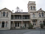
This large former house is significant for its architectural grouping and character and for its environmental prominence on high ground.
A large two storied house constructed in the 1890's on high ground overlooking the river, harbour and with ocean views. A former mansion, finished in stucco and in the late Victorian Italianate style, the building demonstrates a now rare towered character. The external facades, particularly to the Sout West and East are mostly intact.
Assessment 1988 Construction 1890
This information is provided voluntarily as a public service. The information provided is made available in good faith and is derived from sources believed to be reliable and accurate. However, the information is provided solely on the basis that readers will be responsible for making their own assessment of the matters discussed herein and are advised to verify all relevant representations, statements and information.
Constructed from 1904
22385 North Fremantle Precinct
Hillcrest, comprising the original Hillcrest residence, a two storey stucco and tile Victorian Italianate style building of the Federation period, together with a two storey brick and asbestos former maternity hospital in the post World War Two International Style, a hostel constructed in brick and asbestos cement in the post World War Two Perth Regional style, and early Norfolk Island Pines, has cultural heritage significance for the following reasons: The place is a very fine example of a Victorian Italianate style residence with a sympathetic 1934 addition in a matching style; Albeit altered through time to serve alternate uses, the place demonstrates the distinctive accommodation and way of live of the mercantile elite in the early twentieth century, having been built in 1901 for Francis Pearse as a large suburban residence with marine views to the Swan River and Indian Ocean; The place was converted to a maternity hospital for unmarried mothers in 1922 following its donation to the salvation Army by Francis Pearse’s widow Emma, and this use continued for over 50 years, as well as midwife training; and, The place has served as part of a Salvation Army aged care facility since 1978. The 1979 hostel and the 1979 dining room building are aesthetically unsympathetic additions and do not contribute to the cultural heritage significance of the place. The 1958 Wing is of little significance.
Refer to Heritage Council of Western Australia's Register of Heritage Places - Register and Assessment Documentation. Two storey large rendered brick and iron house was designed as an example of the Victorian Italianate style of architecture. Walls are rendered brick with decorative stucco moulding and simple classical-style detailing. The roof has Dutch gables. The house has a three storey balustraded turret and faceted two storey bay. Arched windows with decorative stucco detailing are used extensively. The two storey bullnosed verandah was supported by paired decorated iron posts with a filigree balustrading on the first floor. The house is located within the Hillcrest Salvation Army site and is not easily viewed from the street.
Refer to Heritage Council of Western Australia's Register of Heritage Places - Register and Assessment Documentation. From the nineteenth century, Harvest Road was important as an access route to Point Direction, the location of a sheltered landing place. Boat building yards were located at Point Direction for much of the twentieth century, during which time the Harvest Road jetty also became a popular family swimming and picnic area. Originally, Harvest Road began at Stirling Highway (then called Bruce Street), but from 1899 it was extended through to Queen Victoria Street (then called Victoria Street). Harvest Road has always been a predominantly residential street, developing steadily from the turn of the twentieth century, and characterised at least in its early decades as a place with a large number of rental properties. Three industries on the street were Purina (1935-55) and Nabisco (1955-88) cereal manufacturers (number 3-5), Rowlands Co Cordial, Wine and Spirits manufacturers (1908 to at least 1939, at number 11), and various marine industries, most prominently Browns Boat Building Yard (from c.1900), which was located between Corkhill (Elizabeth) Street and the River. Hillcrest was constructed in 1904 for Francis Pearse, of the prominent Pearse family, and occupied by him from its construction until his death. Francis Pearse earned his fortune as a young man through business interests in Dongara. He was a one of five sons of prominent early Fremantle resident William Pearse. Together with two of his brothers, Pearse established and managed the Pearse Brothers Tannery and Boot Factory in North Fremantle, which operated from 1871 until 1962, when it was demolished. Hillcrest was as an imposing two-storey mansion overlooking the Swan River, located in extensive grounds that ran the length of Helen Street between Harvest Road and John Street. It was constructed to face Helen Street and had substantial outbuildings in the grounds towards Harvest Road, which remained until at least 1939. In 1922, Hillcrest was donated to the Salvation Army by Francis’ widow, apparently at his request. It was first used as a maternity hospital, which also served as a training hospital, and later converted for use as an elderly care facility. This place was included in the 'North Fremantle Heritage Study' (1994) as a place contributing to the development and heritage of North Fremantle. It was also included in the list of heritage places in the City of Fremantle identified by the Fremantle Society (1979/80) - PURPLE -of architectural and historic significance in its own right.
Moderate degree of integrity (original intent clear, current use compatible, high long term sustainability, partially restored, some loss of fabric and altered substantially inside and unsympathetically, exterior relatively intact - south, west and east elevations.). Moderate degree of authenticity with basic original fabric remaining.Some loss of fabric. (These statements based on street survey only).
Condition assessed as good (assessed from streetscape survey only).
This information is provided voluntarily as a public service. The information provided is made available in good faith and is derived from sources believed to be reliable and accurate. However, the information is provided solely on the basis that readers will be responsible for making their own assessment of the matters discussed herein and are advised to verify all relevant representations, statements and information.
24 Harvest Rd North Fremantle
Fremantle
Metropolitan
| Type | Status | Date | Documents |
|---|---|---|---|
| Heritage List | YES | 08 Mar 2007 |
| Type | Status | Date | Documents |
|---|---|---|---|
| (no listings) |
| Type | Status | Date | Grading/Management | |
|---|---|---|---|---|
| Category | ||||
| Municipal Inventory | Adopted | 18 Sep 2000 | Level 3 | |
Individual Building or Group
| Epoch | General | Specific |
|---|---|---|
| Original Use | RESIDENTIAL | Conjoined residence |
| Present Use | RESIDENTIAL | Conjoined residence |
| Style |
|---|
| Victorian Georgian |
| Type | General | Specific |
|---|---|---|
| Wall | BRICK | Rendered Brick |
| Wall | BRICK | Common Brick |
| Roof | METAL | Corrugated Iron |
| Wall | STONE | Limestone |
| General | Specific |
|---|---|
| DEMOGRAPHIC SETTLEMENT & MOBILITY | Land allocation & subdivision |
This information is provided voluntarily as a public service. The information provided is made available in good faith and is derived from sources believed to be reliable and accurate. However, the information is provided solely on the basis that readers will be responsible for making their own assessment of the matters discussed herein and are advised to verify all relevant representations, statements and information.
Constructed from 1913
22385 North Fremantle Precinct
Duplex, 24 Harvest Road, is a typical stone and iron single storey cottage duplex dating from the 1910s. Not withstanding the additions to no. 22 Harvest Road, the place has aesthetic value for its contribution to the streetscape and the surrounding area. It is representative of the typical building stock located within the residential areas of North Fremantle. Historically significant as a representation of typical workers' houses in the North Fremantle area. The half of the duplex pair is a simple and very late example of the Victorian Georgian style of architecture.
Duplex, 22 Harvest Road was originally a single storey stone and iron duplex pair (with 24 Harvest Road) with overall symmetrical facade designed as a late example of the Victorian Georgian style of architecture. Number 24 still remains as a single storey duplex half with rendered limestone and rendered brick walls. Number 22 has had a second storey addition. There is a limestone dividing parapet wall. No 24 has a hipped corrugated iron roof with no eaves. The verandah to 24 is under a separate bull nosed corrugated iron roof supported by decorative timber posts with decorative timber frieze and brackets. The front elevation to 24 has a double hung sash timber window and a timber framed front door. No 22 has a new gabled corrugated iron roof and a bull nosed corrugated iron verandah. The front elevation to 22 has a double hung sash timber window and a timber framed front door to the lower level and a pair of timber framed double hung sash windows to the upper level. Rendered limestone foundations. There is a rendered brick wall to 24.
From the nineteenth century, Harvest Road was important as an access route to Point Direction, the location of a sheltered landing place. Boat building yards were located at Point Direction for much of the twentieth century, during which time the Harvest Road jetty also became a popular family swimming and picnic area. Originally, Harvest Road began at Stirling Highway (then called Bruce Street), but from 1899 it was extended through to Queen Victoria Street (then called Victoria Street). Harvest Road has always been a predominantly residential street, developing steadily from the turn of the twentieth century, and characterised at least in its early decades as a place with a large number of rental properties. Three industries on the street were Purina (1935-55) and Nabisco (1955-88) cereal manufacturers (number 3-5), Rowlands Co Cordial, Wine and Spirits manufacturers (1908 to at least 1939, at number 11), and various marine industries, most prominently Browns Boat Building Yard (from c.1900), which was located between Corkhill (Elizabeth) Street and the River. Duplex, 22-24 Harvest Road was constructed c.1913. Alfred E Westergaard resided at 24 Harvest Road until 1918. Occupants at 22 Harvest Road, and later also 24, changed frequently, suggesting the duplex was used as rental accommodation. From c.1920 Hugh Wauhop lived at 22 Harvest Road for several years. John Wauhop was also resident in the duplex in the early 1920s, although he appears to have moved between the houses at 22, 24 and 26. By the early 1990s, 22 Harvest Road was in disrepair, with a 1996 photograph showing the place having no roof and showing evidence of earlier fire damage. It was sold in 1996 as ‘three stone rooms (uninhabitable)’, and redeveloped through 1997 into a two-storey residence incorporating the surviving fabric of the original stone residence. 24 Harvest Road remains under separate ownership in 2004 as a single-storey stone cottage. This place was included in the 'North Fremantle Heritage Study' (1994) as a place contributing to the development and heritage of North Fremantle. It was also included in the list of heritage places in the City of Fremantle identified by the Fremantle Society (1979/80) - RED -significant for contributing to the unique character of Fremantle.
No 24 has a high degree of integrity (original intent clear, current use compatible, high long term sustainability, restored, some unsympathetic alterations such as rendered walls). High degree of authenticity with much original fabric remaining. (These statements based on street survey only). No 22 has a low to moderate degree of integrity (original intent unclear, current use compatible, high long term sustainability, restored, much loss of fabric and substantial additions). Low to Moderate degree of authenticity with some original fabric remaining. Much loss of fabric. (These statements based on street survey only).
Condition of number 24 is assessed as fair to good.Condition of number 22 is assessed as good (assessed from streetscape survey only).
This information is provided voluntarily as a public service. The information provided is made available in good faith and is derived from sources believed to be reliable and accurate. However, the information is provided solely on the basis that readers will be responsible for making their own assessment of the matters discussed herein and are advised to verify all relevant representations, statements and information.
25 Harvest Rd North Fremantle
Fremantle
Metropolitan
Constructed from 1897
| Type | Status | Date | Documents |
|---|---|---|---|
| Heritage List | YES | 08 Mar 2007 |
| Type | Status | Date | Documents |
|---|---|---|---|
| (no listings) |
| Type | Status | Date | Grading/Management | |
|---|---|---|---|---|
| Category | ||||
| Classified by the National Trust | Classified | 03 Nov 1980 | ||
| Register of the National Estate | Permanent | 28 Sep 1982 | ||
| Municipal Inventory | Adopted | 18 Sep 2000 | Level 2 | |
09128 Harvest Road Precinct
| Name | Type | Year From | Year To |
|---|---|---|---|
| J T Hobbs | Architect | - | - |
Individual Building or Group
| Epoch | General | Specific |
|---|---|---|
| Original Use | RESIDENTIAL | Single storey residence |
| Present Use | RESIDENTIAL | Two storey residence |
| Present Use | RESIDENTIAL | Single storey residence |
| Style |
|---|
| Federation Queen Anne |
| Victorian Filigree |
| Type | General | Specific |
|---|---|---|
| Roof | METAL | Corrugated Iron |
| Wall | BRICK | Pointed Brick |
| Wall | BRICK | Common Brick |
| Wall | STONE | Limestone |
| General | Specific |
|---|---|
| DEMOGRAPHIC SETTLEMENT & MOBILITY | Land allocation & subdivision |
| PEOPLE | Famous & infamous people |
This information is provided voluntarily as a public service. The information provided is made available in good faith and is derived from sources believed to be reliable and accurate. However, the information is provided solely on the basis that readers will be responsible for making their own assessment of the matters discussed herein and are advised to verify all relevant representations, statements and information.
Constructed from 1904
22385 North Fremantle Precinct
Turton House, 25 Harvest Road, is a limestone, brick and iron single storey house dating from the 1900s. It is a fine example of the Federation Queen Anne style of architecture. The place has aesthetic value for its fine design and detailing as well as its contribution to the streetscape and the surrounding area. It is representative of the more affluent building stock located within the residential areas of North Fremantle. Historically significant as a representation of a fine residence in the North Fremantle area. It is significant as an example of Talbot Hobbs residential architecture.
Turton House, 25 Harvest Road, is a single storey limestone, brick and iron house with asymmetrical facade and floor plan designed as an example of the federation Queen Anne style of architecture. Walls are limestone with tuckpointed brick quoins and reveals. The roof form in very complex. Roof is hipped, gabled, Dutch gabled and pyramidal, corrugated iron with an elaborate hip gable which addresses the corner. This is also the location of the front entry. Simple vertical timber ornamentation on roughcast render project beyond the bay. A small gable in the verandah roof serves to signal the location of the front door. Verandah is under separate bullnose corrugated iron roof which wraps around the house. The verandah is supported by turned timber posts with a simple curved frieze.The hand carved railing and elaborately routed balustrading add an elegance to the house. The corbelled brick chimneys are intact. A turret forms the focus of the front elevation. The turret is ornamented by a rendered gable containing a circular window and scrolling. The wide entrance hall leads through a ornamented stucco archway supported on Corinthian columns to the main body of the house. Two storey extensions at the rear of the house were built in 1981. There is a low limestone wall and complementary front garden planting to the front of the house.
From the nineteenth century, Harvest Road was important as an access route to Point Direction, the location of a sheltered landing place. Boat building yards were located at Point Direction for much of the twentieth century, during which time the Harvest Road jetty also became a popular family swimming and picnic area. Originally, Harvest Road began at Stirling Highway (then called Bruce Street), but from 1899 it was extended through to Queen Victoria Street (then called Victoria Street). Harvest Road has always been a predominantly residential street, developing steadily from the turn of the twentieth century, and characterised at least in its early decades as a place with a large number of rental properties. Three industries on the street were Purina (1935-55) and Nabisco (1955-88) cereal manufacturers (number 3-5), Rowlands Co Cordial, Wine and Spirits manufacturers (1908 to at least 1939, at number 11), and various marine industries, most prominently Browns Boat Building Yard (from c.1900), which was located between Corkhill (Elizabeth) Street and the River. Turton House was constructed in c.1904-05 for Arthur Turton and his wife Jessie May Turton, designed by notable architect J. Talbot Hobbs. Jessie was a daughter of James Pearse, one of the three Pearse brothers to found the Pearse Brothers Tannery and Boot Factory. Arthur had been a hardware salesman in Fremantle in the 1890s for Union Stores. He was a prominent public figure in North Fremantle, serving as a Councillor from 1928, and was mayor of North Fremantle from 1932 until 1945. He was apparently popular as mayor, at least in his early years, as it is recorded that when he looked like resigning in 1934 local residents came in droves to Turton House to petition him to stay on. Arthur Turton lived at Turton House until at least 1949. During World War II, Turton was a central place for the war effort assisting Australian servicemen overseas. In 1995, Gwen Evelyn Turton (either a daughter or daughter-in-law to Arthur and Jessie May Turton) died. She appears to have lived a significant portion of her life at Harvest Road, presumably at Turton House. She was honoured in 1989 for 50 years’ voluntary service to the Red Cross. The house was registered by the National Trust in 1980, at which time it was noted that the original turreted roof features were no longer in place. In 1981 a newspaper article records it having been purchased by Craig Bond, son of Perth businessman Alan Bond, and photographs show a turret in place. The house appears to have changed hands several times in the 1980s, at which time extensive additions were made to the rear (south) of the house. These additions were made in a sympathetic style to the original. In March 2016 the house is up for Auction, and real estate ads describe it as a 4 bed, 1 bath home on 985 sq.m with an underground double garage accessed from Turton Street and a swimming pool. The floor plan shows the original house comprises a formal entry and passage way, with two rooms off to the left and three to the right. The first room on the right of the entry (west) has a bay window feature that addresses the corner of the block. The floor plan shows that the large rear addition to the original house comprises a large open plan kitchen/dining and family room, a bedroom and large bathroom to the west side, with a verandah, and a laundry off the east side. A paved area and pool fills the remains of the block. It also appears that there is an addition on the west side of the original portion of the house which comprises a study and a dressing room. This place was included in the 'North Fremantle Heritage Study' (1994) as a place contributing to the development and heritage of North Fremantle. It was also included in the list of heritage places in the City of Fremantle identified by the Fremantle Society (1979/80) - PURPLE -of architectural and historic significance in its own right.
High degree of integrity (original intent clear, current use compatible, high long term sustainability, restored, sympathetic rear extension). High degree of authenticity with much original fabric remaining. (These statements based on street survey only).
Condition assessed as good (assessed from streetscape survey only).
| Name | Type | Year From | Year To |
|---|---|---|---|
| J T Hobbs | Architect | - | - |
This information is provided voluntarily as a public service. The information provided is made available in good faith and is derived from sources believed to be reliable and accurate. However, the information is provided solely on the basis that readers will be responsible for making their own assessment of the matters discussed herein and are advised to verify all relevant representations, statements and information.
The building is significant for its representative architectural character - an imposing large house with protective verandahs, set on high ground with river and ocean views.
A large brick and stone house with surrounding verandahs and corrugated iron roof, constructed in c. 1897 in the late Victorian villa style with turreted roof (now missing) and timber verandah decorative work supplanting the earlier cast iron.
Assessment 1980
This information is provided voluntarily as a public service. The information provided is made available in good faith and is derived from sources believed to be reliable and accurate. However, the information is provided solely on the basis that readers will be responsible for making their own assessment of the matters discussed herein and are advised to verify all relevant representations, statements and information.
26 Harvest Rd North Fremantle
Fremantle
Metropolitan
| Type | Status | Date | Documents |
|---|---|---|---|
| Heritage List | YES | 08 Mar 2007 |
| Type | Status | Date | Documents |
|---|---|---|---|
| (no listings) |
| Type | Status | Date | Grading/Management | |
|---|---|---|---|---|
| Category | ||||
| Municipal Inventory | Adopted | 18 Sep 2000 | Level 3 | |
Individual Building or Group
| Epoch | General | Specific |
|---|---|---|
| Original Use | RESIDENTIAL | Single storey residence |
| Present Use | RESIDENTIAL | Single storey residence |
| Style |
|---|
| Federation Queen Anne |
| Type | General | Specific |
|---|---|---|
| Wall | STONE | Limestone |
| Wall | BRICK | Common Brick |
| Roof | METAL | Corrugated Iron |
| General | Specific |
|---|---|
| DEMOGRAPHIC SETTLEMENT & MOBILITY | Land allocation & subdivision |
This information is provided voluntarily as a public service. The information provided is made available in good faith and is derived from sources believed to be reliable and accurate. However, the information is provided solely on the basis that readers will be responsible for making their own assessment of the matters discussed herein and are advised to verify all relevant representations, statements and information.
Constructed from 1904
22385 North Fremantle Precinct
House, 26 Harvest Road, is a typical stone and iron single storey cottage dating from the 1900s. The place has aesthetic value for its contribution to the streetscape and the surrounding area. It is representative of the typical building stock located within the residential areas of North Fremantle. Historically significant as a representation of typical workers' houses in the North Fremantle area. The place is a very simple example of the Federation Queen Anne style of architecture.
House, 26 Harvest Road, is a single storey stone and iron cottage with asymmetrical facade designed as a very simple example of the Federation Queen Anne style of architecture. Walls are limestone with brick quoins and reveals. Roof is hipped and gabled corrugated iron with no eaves. Gable end is limestone and has a timber finial. Verandah is under a separate bullnose corrugated iron roof supported by turned timber posts. Front elevation is asymmetrical with two timber sash windows with slightly arched brick lintel to the front protruding room and another window and front door under the verandah. The two tall rendered corbelled chimneys are intact. The house is set at an angle to the street behind a limestone and iron front fence.
From the nineteenth century, Harvest Road was important as an access route to Point Direction, the location of a sheltered landing place. Boat building yards were located at Point Direction for much of the twentieth century, during which time the Harvest Road jetty also became a popular family swimming and picnic area. Originally, Harvest Road began at Stirling Highway (then called Bruce Street), but from 1899 it was extended through to Queen Victoria Street (then called Victoria Street). Harvest Road has always been a predominantly residential street, developing steadily from the turn of the twentieth century, and characterised at least in its early decades as a place with a large number of rental properties. Three industries on the street were Purina (1935-55) and Nabisco (1955-88) cereal manufacturers (number 3-5), Rowlands Co Cordial, Wine and Spirits manufacturers (1908 to at least 1939, at number 11), and various marine industries, most prominently Browns Boat Building Yard (from c.1900), which was located between Corkhill (Elizabeth) Street and the River. House, 26 Harvest Road was constructed in 1904 and occupied initially by James Murrie. Early occupants included Mrs E. Hicks (also Higgs) (1905-1907), Robert Gordon (1908-1911), Joseph Coombes, railway employee (1913-1918) Archibald Park (1920-21) and John Wauhop (1922-25). The high turn-over of occupants suggests the place was used for rental accommodation in this period. Rear additions and internal changes to the limestone cottage were approved in 1989, at which time the place was owned by Elizabeth J White. A weatherboard rear extension noted in 1989 had been constructed some time after 1939. The 1989 planning approval included retention of timber floors to the bathroom and laundry, with wet-area floorings installed over the top. This place was included in the 'North Fremantle Heritage Study' (1994) as a place contributing to the development and heritage of North Fremantle. It was also included in the list of heritage places in the City of Fremantle identified by the Fremantle Society (1979/80) - RED -significant for contributing to the unique character of Fremantle.
High degree of integrity (original intent clear, current use compatible, high long term sustainability, restored, sympathetic rear extension). High degree of authenticity with much original fabric remaining. (These statements based on street survey only).
Condition assessed as good (assessed from streetscape survey only).
This information is provided voluntarily as a public service. The information provided is made available in good faith and is derived from sources believed to be reliable and accurate. However, the information is provided solely on the basis that readers will be responsible for making their own assessment of the matters discussed herein and are advised to verify all relevant representations, statements and information.
27 Harvest Rd North Fremantle
Fremantle
Metropolitan
| Type | Status | Date | Documents |
|---|---|---|---|
| Heritage List | YES | 08 Mar 2007 |
| Type | Status | Date | Documents |
|---|---|---|---|
| (no listings) |
| Type | Status | Date | Grading/Management | |
|---|---|---|---|---|
| Category | ||||
| Municipal Inventory | Adopted | 18 Sep 2000 | Level 3 | |
Individual Building or Group
| Epoch | General | Specific |
|---|---|---|
| Present Use | RESIDENTIAL | Single storey residence |
| Original Use | RESIDENTIAL | Single storey residence |
| Style |
|---|
| Victorian Georgian |
| Type | General | Specific |
|---|---|---|
| Roof | TIMBER | Shingle |
| Wall | RENDER | Smooth |
| Wall | STONE | Limestone |
| General | Specific |
|---|---|
| DEMOGRAPHIC SETTLEMENT & MOBILITY | Land allocation & subdivision |
This information is provided voluntarily as a public service. The information provided is made available in good faith and is derived from sources believed to be reliable and accurate. However, the information is provided solely on the basis that readers will be responsible for making their own assessment of the matters discussed herein and are advised to verify all relevant representations, statements and information.
Constructed from 1892
22385 North Fremantle Precinct
House, 27 Harvest Road, is a typical limestone and timber shingle single storey cottage dating from the 1890s. The place has aesthetic value for its contribution to the streetscape and the surrounding area. It is representative of the typical building stock located within the residential areas of North Fremantle. Historically significant as a representation of typical workers' houses in the North Fremantle area. The place is a simple example of the Victorian Georgian style of architecture. it is one of the first houses built in the area.
House, 27 Harvest Road, is a single storey limestone and shingle cottage with symmetrical facade designed as an example of the Victorian Georgian style of architecture. Walls are limestone with rendered reveals around windows. Roof is hipped timber shingles with no eaves. Verandah is under the same pitch shingle roof, supported by square timber posts. Front elevation is symmetrical with two timber sash windows and a central front door. The verandah has a timber floor. There is no front fence. A rear limestone addition, also with shingled roof, is visible from the street. Aerial views show a corrugated iron roofed structure in the rear yard.
From the nineteenth century, Harvest Road was important as an access route to Point Direction, the location of a sheltered landing place. Boat building yards were located at Point Direction for much of the twentieth century, during which time the Harvest Road jetty also became a popular family swimming and picnic area. Originally, Harvest Road began at Stirling Highway (then called Bruce Street), but from 1899 it was extended through to Queen Victoria Street (then called Victoria Street). Harvest Road has always been a predominantly residential street, developing steadily from the turn of the twentieth century, and characterised at least in its early decades as a place with a large number of rental properties. Three industries on the street were Purina (1935-55) and Nabisco (1955-88) cereal manufacturers (number 3-5), Rowlands Co Cordial, Wine and Spirits manufacturers (1908 to at least 1939, at number 11), and various marine industries, most prominently Browns Boat Building Yard (from c.1900), which was located between Corkhill (Elizabeth) Street and the River. Constructed c.1892-93, this place was one of the first two permanent buildings erected on Harvest Road, noted in 1892 Rate Books as a 3-room cottage, with a carriage building and second 3-room cottage also on site from 1893. It cannot be determined whether 27 or 29 was constructed first, as both were built on portions of the same Lot for George Staples, whose occupation is recorded as ‘lumper’ in the Post Office Directories and ‘carrier’ on the Certificate of Title. In 1891, George Staples owned Lot 28, on which numbers 27 and 29 were constructed. He resided at 27 Harvest Road until 1900, after which he and his wife Margaret moved to 11 John Street. From 1901, the place was occupied by John Staples, who is likely to have been a son of George and Margaret. From 1902 to 1905 Frank Staples is listed at 27, with John not listed as resident in the street at all, and Mrs Mary Taylor appears to have rented a room at 27 Harvest Road from 1902-04. From 1905, Charles Posselt lived at the house for several years, possibly until 1914, although records are unclear. He then moved to 21 Harvest Road. From 1915 it appears that John Staples, previously resident at 29 Harvest Road, and owner of all of Lot 28, moved next door to 27, where he continues to be recorded well into the 1920s. The 1921 Rate Books note him living in a four-room stone cottage at 27 Harvest Road. He is listed at 27 Harvest Road in 1949 Post Office Directories, and it is likely that he lived at the place until his death in 1962. Following John’s death, House, 27 Harvest Road, which had been given a separate title to neighbouring 29 Harvest Road from 1954, was transferred in equal half-shares to his bachelor son, Ronald John Staples (clerk) and Della Mavis Davey (married woman). Ronald, born in 1910, lived his entire life on Harvest Road, aside from his 4 years in the RAAF during World War Two. He was a prominent North Fremantle figure, serving as a Councillor from 1940 to his death in 1973. The property changed hands a number of times before being purchased in 1975 by Roger Brian Bitton (Engineering Draftsman). In 1985 the title was amalgamated with that for adjacent 29 Harvest Road, in line with the original subdivision of Lot 28, and both 27 and 29 came into the ownership of Daphne Marie Tye, married woman, of Karratha. This place was included in the 'North Fremantle Heritage Study' (1994) as a place contributing to the development and heritage of North Fremantle. It was also included in the list of heritage places in the City of Fremantle identified by the Fremantle Society (1979/80) - RED -significant for contributing to the unique character of Fremantle.
High degree of integrity (original intent clear, current use compatible, high long term sustainability, restored, sympathetic rear extension). High degree of authenticity with much original fabric remaining. (These statements based on street survey only).
Condition assessed as fair (assessed from streetscape survey only).
This information is provided voluntarily as a public service. The information provided is made available in good faith and is derived from sources believed to be reliable and accurate. However, the information is provided solely on the basis that readers will be responsible for making their own assessment of the matters discussed herein and are advised to verify all relevant representations, statements and information.
28 Harvest Rd North Fremantle
Fremantle
Metropolitan
| Type | Status | Date | Documents |
|---|---|---|---|
| Heritage List | YES | 08 Mar 2007 |
| Type | Status | Date | Documents |
|---|---|---|---|
| (no listings) |
| Type | Status | Date | Grading/Management | |
|---|---|---|---|---|
| Category | ||||
| Municipal Inventory | Adopted | 18 Sep 2000 | Level 3 | |
Individual Building or Group
| Epoch | General | Specific |
|---|---|---|
| Original Use | RESIDENTIAL | Single storey residence |
| Present Use | RESIDENTIAL | Two storey residence |
| Type | General | Specific |
|---|---|---|
| Wall | BRICK | Face Brick |
| Roof | METAL | Corrugated Iron |
| Wall | TIMBER | Weatherboard |
| Wall | STONE | Limestone |
| General | Specific |
|---|---|
| DEMOGRAPHIC SETTLEMENT & MOBILITY | Land allocation & subdivision |
This information is provided voluntarily as a public service. The information provided is made available in good faith and is derived from sources believed to be reliable and accurate. However, the information is provided solely on the basis that readers will be responsible for making their own assessment of the matters discussed herein and are advised to verify all relevant representations, statements and information.
Constructed from 1904
22385 North Fremantle Precinct
House, 28 Harvest Road, is a modified stone, weatherboard and iron double storey cottage with tower dating from the 1900s. Notwithstanding it alterations and additions the place has aesthetic value for its contribution to the streetscape and the surrounding area. It is representative of modified building stock located within the residential areas of North Fremantle. Historically significant as a modified representation of typical workers' houses in the North Fremantle area.
House, 28 Harvest Road, is a double storey stone, weatherboard and iron cottage with asymmetrical façade. This house has been substantially altered and extended. Originally a single storey dwelling, it is now a double storey dwelling with a three storey tower. Walls to the ground floor (original dwelling) are limestone with red brick quoins and reveals.The extended upper floors are timber framed and weatherboard clad. Roof is hipped and gabled corrugated iron with no eaves. The roof to the tower is also corrugated iron in a pyramidal form. Verandah is under separate bullnose corrugated iron roof and wraps around two sides of the building. Verandah is supported by turned timber posts. Sited on a corner block the house has two main elevations. The original front elevation faces Harvest Road. There is a rendered brick and iron fence to both street elevations.
From the nineteenth century, Harvest Road was important as an access route to Point Direction, the location of a sheltered landing place. Boat building yards were located at Point Direction for much of the twentieth century, during which time the Harvest Road jetty also became a popular family swimming and picnic area. Originally, Harvest Road began at Stirling Highway (then called Bruce Street), but from 1899 it was extended through to Queen Victoria Street (then called Victoria Street). Harvest Road has always been a predominantly residential street, developing steadily from the turn of the twentieth century, and characterised at least in its early decades as a place with a large number of rental properties. Three industries on the street were Purina (1935-55) and Nabisco (1955-88) cereal manufacturers (number 3-5), Rowlands Co Cordial, Wine and Spirits manufacturers (1908 to at least 1939, at number 11), and various marine industries, most prominently Browns Boat Building Yard (from c.1900), which was located between Corkhill (Elizabeth) Street and the River. House, 28 Harvest Road was constructed in 1904 and initially occupied by Harry M Jackman. It may have replaced an earlier cottage, recorded as possibly dating from the 1880s, which had been demolished some time before 1897, as the Lot is shown as vacant land on an 1897 map. From its construction until 1920, when William Payne began living at the place, the occupancy of the place changed every year, with the exception of slightly longer residences of Frederick Grosse (1905-06), David McKinnon (1907-08) and John Herbert Kimber (1914-16). This suggests that the place was rented out during this period. From 1921 to 1935, 28 Harvest Road was owned by Emily Reay, although she does not appear to have lived at the place. From 1932 the house was occupied by Albert Leaver and his wife Thelma, who at some point prior to 1955 also became the owners. Albert was a mechanic and Thelma was noted for her involvement in the local Red Cross. A 1939 Sewerage plan shows the place as a 4-room brick and stone house with a tank stand, water closet and pond. The Leavers remained at the house until at least 1979. This place was included in the list of heritage places in the City of Fremantle identified by the Fremantle Society (1979/80) - RED -significant for contributing to the unique character of Fremantle.
Moderate degree of integrity (original intent partially clear, current use compatible, high long term sustainability, restored, some loss of fabric and substantial alterations and additions). Moderate degree of authenticity with basic original fabric remaining. Some loss of fabric. (These statements based on street survey only).
Condition assessed as good (assessed from streetscape survey only).
This information is provided voluntarily as a public service. The information provided is made available in good faith and is derived from sources believed to be reliable and accurate. However, the information is provided solely on the basis that readers will be responsible for making their own assessment of the matters discussed herein and are advised to verify all relevant representations, statements and information.
29 Harvest Rd North Fremantle
Fremantle
Metropolitan
| Type | Status | Date | Documents |
|---|---|---|---|
| Heritage List | YES | 08 Mar 2007 |
| Type | Status | Date | Documents |
|---|---|---|---|
| (no listings) |
| Type | Status | Date | Grading/Management | |
|---|---|---|---|---|
| Category | ||||
| Municipal Inventory | Adopted | 18 Sep 2000 | Level 3 | |
Individual Building or Group
| Epoch | General | Specific |
|---|---|---|
| Original Use | RESIDENTIAL | Single storey residence |
| Present Use | RESIDENTIAL | Two storey residence |
| Style |
|---|
| Victorian Georgian |
| Type | General | Specific |
|---|---|---|
| Roof | METAL | Corrugated Iron |
| Wall | STONE | Limestone |
| General | Specific |
|---|---|
| DEMOGRAPHIC SETTLEMENT & MOBILITY | Land allocation & subdivision |
This information is provided voluntarily as a public service. The information provided is made available in good faith and is derived from sources believed to be reliable and accurate. However, the information is provided solely on the basis that readers will be responsible for making their own assessment of the matters discussed herein and are advised to verify all relevant representations, statements and information.
Constructed from 1892
House, 29 Harvest Road, is a typical limestone and iron single storey cottage dating from the 1890s. The place has aesthetic value for its contribution to the streetscape and the surrounding area. It is representative of the typical building stock located within the residential areas of North Fremantle. Historically significant as a representation of typical workers' houses in the North Fremantle area. The place is a simple example of the Victorian Georgian style of architecture. It is one of earliest homes built in this particular area of North Fremantle.
House, 29 Harvest Road, is a single storey limestone and iron cottage with symmetrical facade designed as a late example of the Victorian Georgian style of architecture. Walls are limestone. Roof is hipped corrugated iron with no eaves. Verandah is under a separate corrugated iron roof. Verandah is supported by timber posts. Front elevation is symmetrical with two timber sash windows and a central front door. The verandah is at ground level and has a timber floor. Extensions to the rear. High level limestone fence to front boundary.
From the nineteenth century, Harvest Road was important as an access route to Point Direction, the location of a sheltered landing place. Boat building yards were located at Point Direction for much of the twentieth century, during which time the Harvest Road jetty also became a popular family swimming and picnic area. Originally, Harvest Road began at Stirling Highway (then called Bruce Street), but from 1899 it was extended through to Queen Victoria Street (then called Victoria Street). Harvest Road has always been a predominantly residential street, developing steadily from the turn of the twentieth century, and characterised at least in its early decades as a place with a large number of rental properties. Three industries on the street were Purina (1935-55) and Nabisco (1955-88) cereal manufacturers (number 3-5), Rowlands Co Cordial, Wine and Spirits manufacturers (1908 to at least 1939, at number 11), and various marine industries, most prominently Browns Boat Building Yard (from c.1900), which was located between Corkhill (Elizabeth) Street and the River. Constructed c.1892-93, this place was one of the first two permanent building erected on Harvest Road, noted in 1892 Rate Books as a 3-room cottage, with a carriage building and second 3-room cottage also on site from 1893. It cannot be determined whether 27 or 29 was constructed first, as both were built on portions of the same Lot for George Staples, whose occupation is recorded as ‘lumper’ in the Post Office Directories and ‘carrier’ on the Certificate of Title. In 1891, George Staples owned Lot 28, on which numbers 27 and 29 were constructed, and lived at 27 Harvest Road until 1900. From 1898 to 1954, John Edward Staples owned the portion of Lot 28 on which 29 Harvest Road is located (He retained ownership of the portion of Lot 28 in which 27 Harvest Road is located until his death in 1962). 29 Harvest Road appears to have been rented out, as the occupants changed every year or two. George Bishop was the longest-resident tenant in the early period, living at the place from 1902 to 1906, after which John Staples moved in. John is listed in 1901 as residing for a year at 27 Harvest Road, and then from 1902 to 1906, he is not shown in Post Office Directory listings for Harvest Road. From 1907 to 1914 John resided at House, 29 Harvest Road, after which he moved next door to 27, where he appears to have lived until his death in 1962. James D Gibbs is then recorded as tenant at 29 (1915-19), followed by William A. Lendon (1920-21) and then Joseph G Cassells from 1922 to at least 1925. By 1934 Frederick G White was living at the place, and it was recorded as a four-room timber house. Throughout the 1940s, John Dearle is listed as the tenant. In 1954, the portion of Lot 28 on which House, 29 Harvest Road is situated was sold on a separate title to Alma Ellen Bolitho (widow) and Joyce Queenie Richardson (married woman). Subsequent owners were Guiseppe Positana (labourer) and his wife Maria (1958-60), John Daniel Congear (1960-67) and John Musham (Butcher) and his wife Marie (1967-77). John Musham was declared bankrupt in 1969. From 1977, the property was transferred to Daphne Marie Musham, whose occupation is listed as ‘home duties’, and who lived at the place at the time she took ownership. In 1985 the title for 29 Harvest Road was re-amalgamated with that for adjacent 27 Harvest Road, and the entire of the original Lot 28 was transferred to Daphne Marie Tye (married woman), of Karratha, who is presumably the same Daphne Marie who had owned 29 Harvest Road from 1977. Extensions at the rear of the cottage (1993). This place was included in the 'North Fremantle Heritage Study' (1994) as a place contributing to the development and heritage of North Fremantle. It was also included in the list of heritage places in the City of Fremantle identified by the Fremantle Society (1979/80) - RED -significant for contributing to the unique character of Fremantle.
Moderate degree of integrity (original intent clear, current use compatible, high long term sustainability, partially restored, some loss of fabric and previous rear addition). Moderate degree of authenticity with basic original fabric remaining.Some loss of fabric. (These statements based on street survey only).
Condition assessed as fair to good (assessed from streetscape survey only).
This information is provided voluntarily as a public service. The information provided is made available in good faith and is derived from sources believed to be reliable and accurate. However, the information is provided solely on the basis that readers will be responsible for making their own assessment of the matters discussed herein and are advised to verify all relevant representations, statements and information.
31 Harvest Rd North Fremantle
Fremantle
Metropolitan
| Type | Status | Date | Documents |
|---|---|---|---|
| Heritage List | YES | 08 Mar 2007 |
| Type | Status | Date | Documents |
|---|---|---|---|
| (no listings) |
| Type | Status | Date | Grading/Management | |
|---|---|---|---|---|
| Category | ||||
| Municipal Inventory | Adopted | 18 Sep 2000 | Level 3 | |
Individual Building or Group
| Epoch | General | Specific |
|---|---|---|
| Original Use | RESIDENTIAL | Single storey residence |
| Present Use | RESIDENTIAL | Single storey residence |
| Style |
|---|
| Victorian Georgian |
| Type | General | Specific |
|---|---|---|
| Wall | BRICK | Rendered Brick |
| Roof | METAL | Corrugated Iron |
| General | Specific |
|---|---|
| DEMOGRAPHIC SETTLEMENT & MOBILITY | Land allocation & subdivision |
This information is provided voluntarily as a public service. The information provided is made available in good faith and is derived from sources believed to be reliable and accurate. However, the information is provided solely on the basis that readers will be responsible for making their own assessment of the matters discussed herein and are advised to verify all relevant representations, statements and information.
Constructed from 1895, Constructed from 1892
22385 North Fremantle Precinct
House, 31 Harvest Road, is a typical rendered masonry and iron single storey cottage dating from the 1890s. The place has aesthetic value for its contribution to the streetscape and the surrounding area. It is representative of the typical building stock located within the residential areas of North Fremantle. Historically significant as a representation of typical workers' houses in the North Fremantle area. The place is a very late simple example of the Victorian Georgian style of architecture.
Single storey limestone and iron cottage with symmetrical facade designed as an example of the Victorian Georgian style of architecture. Walls are limestone with red brick quoins. Roof is hipped corrugated iron with no eaves. Verandah is a separate skillion. Front elevation is symmetrical with two timber sash windows and a central front door. A high masonry and timber fence is located along the front site boundary. Lots 2,3,4,5,6,7 & 8 have been subdivided and are for Historic Record Only. The original HOUSE, 31 Harvest Road remains as a Level 3.
From the nineteenth century, Harvest Road was important as an access route to Point Direction, the location of a sheltered landing place. Boat building yards were located at Point Direction for much of the twentieth century, during which time the Harvest Road jetty also became a popular family swimming and picnic area. Originally, Harvest Road began at Stirling Highway (then called Bruce Street), but from 1899 it was extended through to Queen Victoria Street (then called Victoria Street). Harvest Road has always been a predominantly residential street, developing steadily from the turn of the twentieth century, and characterised at least in its early decades as a place with a large number of rental properties. Three industries on the street were Purina (1935-55) and Nabisco (1955-88) cereal manufacturers (number 3-5), Rowlands Co Cordial, Wine and Spirits manufacturers (1908 to at least 1939, at number 11), and various marine industries, most prominently Browns Boat Building Yard (from c.1900), which was located between Corkhill (Elizabeth) Street and the River. House, 31 Harvest Road is one of a cluster of five cottages built within three years (1892 to 1895) at 27-31 and 30-32 Harvest Road. It was constructed in 1893 for Henry Russell (plasterer) as a two-room cottage. Henry Russell lived at the place until 1900, followed for a year by George Russell. George Bishop then resided at 31 Harvest Road from 1902 to 1906. From 1908 to 1915, George Sanson occupied the house. Following his period of occupancy, residents changed several times until William Coughlan moved in, in 1919, and remained at the place until at least 1935. The place underwent renovations in 2004. The rendered walls were stripped to reveal original limestone, the verandah was reconstructed and a residential development was built behind the house called "Harvest Lane". This place was included in the 'North Fremantle Heritage Study' (1994) as a place contributing to the development and heritage of North Fremantle. It was also included in the list of heritage places in the City of Fremantle identified by the Fremantle Society (1979/80) - RED -significant for contributing to the unique character of Fremantle.
Moderate degree of integrity (original intent clear, current use compatible, high long term sustainability, partially restored currently (2004) under construction, some loss of fabric and previous unsympathetic alterations). Moderate degree of authenticity with basic original fabric remaining.Some loss of fabric. (These statements based on street survey only).
Condition assessed as fair to poor but currently under construction. (assessed from streetscape survey only).
This information is provided voluntarily as a public service. The information provided is made available in good faith and is derived from sources believed to be reliable and accurate. However, the information is provided solely on the basis that readers will be responsible for making their own assessment of the matters discussed herein and are advised to verify all relevant representations, statements and information.
32 Harvest Rd North Fremantle
Fremantle
Metropolitan
| Type | Status | Date | Documents |
|---|---|---|---|
| Heritage List | YES | 08 Mar 2007 |
| Type | Status | Date | Documents |
|---|---|---|---|
| (no listings) |
| Type | Status | Date | Grading/Management | |
|---|---|---|---|---|
| Category | ||||
| Municipal Inventory | Adopted | 18 Sep 2000 | Level 3 | |
Individual Building or Group
| Epoch | General | Specific |
|---|---|---|
| Present Use | RESIDENTIAL | Single storey residence |
| Original Use | RESIDENTIAL | Single storey residence |
| Type | General | Specific |
|---|---|---|
| Wall | BRICK | Rendered Brick |
| Wall | STONE | Limestone |
| Roof | TILE | Terracotta Tile |
| General | Specific |
|---|---|
| DEMOGRAPHIC SETTLEMENT & MOBILITY | Land allocation & subdivision |
This information is provided voluntarily as a public service. The information provided is made available in good faith and is derived from sources believed to be reliable and accurate. However, the information is provided solely on the basis that readers will be responsible for making their own assessment of the matters discussed herein and are advised to verify all relevant representations, statements and information.
Constructed from 1892, Constructed from 1895
22385 North Fremantle Precinct
House, 32 Harvest Road, is a stone, rendered brick and tile single storey house dating from the 1890s with two storey additions. The place has aesthetic value for its contribution to the streetscape and the surrounding area. It is representative of the typical building stock located within the residential areas of North Fremantle. Historically significant as a representation of typical workers' houses in the North Fremantle area.
Single storey limestone, rendered brick and recent Zincalume house with asymmetrical façade, and a two storey rear addition. Walls are painted rendered brick sitting on a high limestone foundation. Roof is corrugated galvanised iron with gable to the front elevation with timber louvred decoration in a sunrise design. The verandah has a separate skillion roof. There is a low rendered brick and timber fence to the front boundary line. Substantial rear two storey additions and alterations.
From the nineteenth century, Harvest Road was important as an access route to Point Direction, the location of a sheltered landing place. Boat building yards were located at Point Direction for much of the twentieth century, during which time the Harvest Road jetty also became a popular family swimming and picnic area. Originally, Harvest Road began at Stirling Highway (then called Bruce Street), but from 1899 it was extended through to Queen Victoria Street (then called Victoria Street). Harvest Road has always been a predominantly residential street, developing steadily from the turn of the twentieth century, and characterised at least in its early decades as a place with a large number of rental properties. Three industries on the street were Purina (1935-55) and Nabisco (1955-88) cereal manufacturers (number 3-5), Rowlands Co Cordial, Wine and Spirits manufacturers (1908 to at least 1939, at number 11), and various marine industries, most prominently Browns Boat Building Yard (from c.1900), which was located between Corkhill (Elizabeth) Street and the River. House, 32 Harvest Road is one of a cluster of five cottages built within three years (1892 to 1895) at 27-31 and 30-32 Harvest Road. It was constructed c.1895. The place had no long-term occupants, and appears to have often been vacant, until Arthur and Edith M Reeves moved in. They lived at the place from 1910 to 1921. A 1939 sewerage plan shows the place set back from the road. The front portion is brick, with a porch set into the square footprint at the southwest corner. To the rear is a stone section, and behind that a timber section, with a timber laundry attached to the northwest corner and no rear verandah shown. In 2009 the roof was tiled, but aerial views in 2016 show a Zincalume roof. The place seems to have undergone substantial two storey rear additions, as second storey balconies and windows are visible from street level. This place was included in the 'North Fremantle Heritage Study' (1994) as a place contributing to the development and heritage of North Fremantle.
Low to Moderate degree of integrity (original intent clear, current use compatible, not restored, some loss of fabric and previous unsympathetic alterations). Low to Moderate degree of authenticity with some original fabric remaining. Some loss of fabric. (These statements based on street survey only).
Condition assessed as poor (assessed from streetscape survey only).
This information is provided voluntarily as a public service. The information provided is made available in good faith and is derived from sources believed to be reliable and accurate. However, the information is provided solely on the basis that readers will be responsible for making their own assessment of the matters discussed herein and are advised to verify all relevant representations, statements and information.
36 Harvest Rd North Fremantle
Fremantle
Metropolitan
| Type | Status | Date | Documents |
|---|---|---|---|
| Heritage List | YES | 08 Mar 2007 |
| Type | Status | Date | Documents |
|---|---|---|---|
| (no listings) |
| Type | Status | Date | Grading/Management | |
|---|---|---|---|---|
| Category | ||||
| Municipal Inventory | Adopted | 18 Sep 2000 | Level 3 | |
Individual Building or Group
| Epoch | General | Specific |
|---|---|---|
| Original Use | RESIDENTIAL | Single storey residence |
| Present Use | RESIDENTIAL | Single storey residence |
| Style |
|---|
| Victorian Georgian |
| Type | General | Specific |
|---|---|---|
| Wall | BRICK | Face Brick |
| Wall | STONE | Limestone |
| Roof | METAL | Corrugated Iron |
| General | Specific |
|---|---|
| DEMOGRAPHIC SETTLEMENT & MOBILITY | Land allocation & subdivision |
This information is provided voluntarily as a public service. The information provided is made available in good faith and is derived from sources believed to be reliable and accurate. However, the information is provided solely on the basis that readers will be responsible for making their own assessment of the matters discussed herein and are advised to verify all relevant representations, statements and information.
Constructed from 1904
22385 North Fremantle Precinct
House, 36 Harvest Road, is a typical stone and iron single storey cottage dating from the 1900s. The place has aesthetic value for its contribution to the streetscape and the surrounding area. It is representative of the typical building stock located within the residential areas of North Fremantle. Historically significant as a representation of typical workers' houses in the North Fremantle area. The place is a simple example of the Victorian Georgian style of architecture.
House, 36 Harvest Road, is a single storey stone and iron cottage with symmetrical facade designed as a late example of the Victorian Georgian style of architecture. Walls are limestone with face brick quoins and reveals. Roof is hipped corrugated iron with no eaves. Verandah is under a separate corrugated iron roof. Verandah is supported by square timber posts. Front elevation is symmetrical with two timber sash windows and a central front door. The house is elevated on limestone foundations.
From the nineteenth century, Harvest Road was important as an access route to Point Direction, the location of a sheltered landing place. Boat building yards were located at Point Direction for much of the twentieth century, during which time the Harvest Road jetty also became a popular family swimming and picnic area. Originally, Harvest Road began at Stirling Highway (then called Bruce Street), but from 1899 it was extended through to Queen Victoria Street (then called Victoria Street). Harvest Road has always been a predominantly residential street, developing steadily from the turn of the twentieth century, and characterised at least in its early decades as a place with a large number of rental properties. Three industries on the street were Purina (1935-55) and Nabisco (1955-88) cereal manufacturers (number 3-5), Rowlands Co Cordial, Wine and Spirits manufacturers (1908 to at least 1939, at number 11), and various marine industries, most prominently Browns Boat Building Yard (from c.1900), which was located between Corkhill (Elizabeth) Street and the River. House, 36 Harvest Road was constructed in 1904 for Peter Johnson, who lived there until 1912. After this, Mrs Mary A Johnson is recorded at the place until at least 1925. Peter Johnson worked from the 1890s at Rocky Bay Quarry, and lived for a time in North Fremantle’s ‘canvas town’. From 1916, Mary appears to have rented out a room to various members of the Charlton family. From 1916, the Charlton family appears as second occupant resident at the place. Richard B Charlton, teacher, is resident from 1916 to 1917, after which Leslie Charlton and his wife Ivy are listed. From the 1940s, Mrs Johnson is no longer listed at the place, but the Charltons remained until at least 1949. Les Charlton was a teacher at North Fremantle, and later in life served from 1949 to 1952 as mayor of North Fremantle. Ivy was keenly involved in the activities of St Mary’s Anglican Church, as well as being a Red Cross volunteer. This place was included in the 'North Fremantle Heritage Study' (1994) as a place contributing to the development and heritage of North Fremantle. It was also included in the list of heritage places in the City of Fremantle identified by the Fremantle Society (1979/80) - RED -significant for contributing to the unique character of Fremantle.
High degree of integrity (original intent clear, current use compatible, high long term sustainability, restored). High degree of authenticity with much original fabric remaining. (These statements based on street survey only).
Condition assessed as good (assessed from streetscape survey only).
This information is provided voluntarily as a public service. The information provided is made available in good faith and is derived from sources believed to be reliable and accurate. However, the information is provided solely on the basis that readers will be responsible for making their own assessment of the matters discussed herein and are advised to verify all relevant representations, statements and information.
38 Harvest Rd North Fremantle
Fremantle
Metropolitan
| Type | Status | Date | Documents |
|---|---|---|---|
| Heritage List | YES | 08 Mar 2007 |
| Type | Status | Date | Documents |
|---|---|---|---|
| (no listings) |
| Type | Status | Date | Grading/Management | |
|---|---|---|---|---|
| Category | ||||
| Municipal Inventory | Adopted | 18 Sep 2000 | Level 3 | |
Individual Building or Group
| Epoch | General | Specific |
|---|---|---|
| Present Use | RESIDENTIAL | Single storey residence |
| Original Use | RESIDENTIAL | Single storey residence |
| Style |
|---|
| Victorian Georgian |
| Type | General | Specific |
|---|---|---|
| Wall | BRICK | Painted Brick |
| Roof | METAL | Corrugated Iron |
| Wall | STONE | Limestone |
| Wall | TIMBER | Weatherboard |
| General | Specific |
|---|---|
| DEMOGRAPHIC SETTLEMENT & MOBILITY | Land allocation & subdivision |
This information is provided voluntarily as a public service. The information provided is made available in good faith and is derived from sources believed to be reliable and accurate. However, the information is provided solely on the basis that readers will be responsible for making their own assessment of the matters discussed herein and are advised to verify all relevant representations, statements and information.
Constructed from 1904
22385 North Fremantle Precinct
House, 38 Harvest Road is a stone and iron single storey cottage dating from the 1900s. The place has aesthetic value for its contribution to the streetscape and the surrounding area. It is representative of the typical building stock located within the residential areas of North Fremantle. Historically significant as a representation of typical workers' houses in the North Fremantle area. The place is a simple example of the Victorian Georgian style of architecture.
Single storey stone and iron cottage originally with symmetrical facade designed as a late example of the Victorian Georgian style of architecture. The place has a single storey weatherboard extension to the east side. Walls are limestone with painted brick quoins and reveals. Roof is hipped corrugated iron with no eaves. Verandah is under separate corrugated iron roof. Verandah is supported by decorative timber posts with brackets. Front elevation is no longer symmetrical with two timber sash windows and a central front door to the original section and another window to the extension. The house is elevated from street level. There is a limestone wall along the front boundary and a set of brick stairs leading from the front boundary up to the verandah. This place contains a limestone feature - front boundary wall.
From the nineteenth century, Harvest Road was important as an access route to Point Direction, the location of a sheltered landing place. Boat building yards were located at Point Direction for much of the twentieth century, during which time the Harvest Road jetty also became a popular family swimming and picnic area. Originally, Harvest Road began at Stirling Highway (then called Bruce Street), but from 1899 it was extended through to Queen Victoria Street (then called Victoria Street). Harvest Road has always been a predominantly residential street, developing steadily from the turn of the twentieth century, and characterised at least in its early decades as a place with a large number of rental properties. Three industries on the street were Purina (1935-55) and Nabisco (1955-88) cereal manufacturers (number 3-5), Rowlands Co Cordial, Wine and Spirits manufacturers (1908 to at least 1939, at number 11), and various marine industries, most prominently Browns Boat Building Yard (from c.1900), which was located between Corkhill (Elizabeth) Street and the River. House, 38 Harvest Road was constructed c.1904 for Thomas W Taylor, town clerk for North Fremantle, who is shown as resident at the site from 1903. The following occupant, W.D. Evans, was also town clerk for North Fremantle, and lived at the place from 1906 to 1908. For the next twenty years there was a relatively rapid turn-over of occupants, including Frederick G White (1909-10), George Smith (1911-12), John F Welchman (1913), Norman E Miner (1914-15), Thomas Tazewell (1916-17) and Peter Casserly (1919 -21) It appears that the place was rented out during this period. Patrick O’Loughlin then occupied the house from 1922 to the late 1940s. This place was included in the list of heritage places in the City of Fremantle identified by the Fremantle Society (1979/80) - RED -significant for contributing to the unique character of Fremantle.
Moderate degree of integrity (original intent clear, current use compatible, high long term sustainability, restored, some loss of fabric and extensive additions Moderate degree of authenticity with basic original fabric remaining.Some loss of fabric. (These statements based on street survey only).
Condition assessed as good (assessed from streetscape survey only).
This information is provided voluntarily as a public service. The information provided is made available in good faith and is derived from sources believed to be reliable and accurate. However, the information is provided solely on the basis that readers will be responsible for making their own assessment of the matters discussed herein and are advised to verify all relevant representations, statements and information.
40 Harvest Rd North Fremantle
Fremantle
Metropolitan
| Type | Status | Date | Documents |
|---|---|---|---|
| Heritage List | YES | 08 Mar 2007 |
| Type | Status | Date | Documents |
|---|---|---|---|
| (no listings) |
| Type | Status | Date | Grading/Management | |
|---|---|---|---|---|
| Category | ||||
| Municipal Inventory | Adopted | 18 Sep 2000 | Level 3 | |
Individual Building or Group
| Epoch | General | Specific |
|---|---|---|
| Present Use | RESIDENTIAL | Single storey residence |
| Original Use | RESIDENTIAL | Single storey residence |
| Style |
|---|
| Victorian Georgian |
| Type | General | Specific |
|---|---|---|
| Wall | STONE | Limestone |
| Roof | METAL | Corrugated Iron |
| Wall | BRICK | Face Brick |
| General | Specific |
|---|---|
| DEMOGRAPHIC SETTLEMENT & MOBILITY | Land allocation & subdivision |
This information is provided voluntarily as a public service. The information provided is made available in good faith and is derived from sources believed to be reliable and accurate. However, the information is provided solely on the basis that readers will be responsible for making their own assessment of the matters discussed herein and are advised to verify all relevant representations, statements and information.
Constructed from 1904
22385 North Fremantle Precinct
House, 40 Harvest Road, is a typical stone and iron single storey cottage dating from the 1900s. The place has aesthetic value for its contribution to the streetscape and the surrounding area. It is representative of the typical building stock located within the residential areas of North Fremantle. Historically significant as a representation of typical workers' houses in the North Fremantle area. The place is a simple example of the Victorian Georgian style of architecture.
Single storey stone and iron cottage with symmetrical facade designed as a late example of the Victorian Georgian style of architecture. Walls are painted limestone with red face brick quoins and reveals. Roof is hipped corrugated iron with no eaves. Verandah is under separate corrugated iron roof. Verandah is supported by timber posts with decorative timber brackets. Front elevation is symmetrical with two timber sash windows and a central front door. The original rendered corbelled chimneys are intact. The house is elevated and sits on limestone foundations. There is a limestone and timber picket fence to the front boundary line and a set of rendered masonry stairs leading up to the verandah. Aerial views show a substantial rear addition/alterations. This place contains a limestone feature - limestone foundations and front boundary wall.
From the nineteenth century, Harvest Road was important as an access route to Point Direction, the location of a sheltered landing place. Boat building yards were located at Point Direction for much of the twentieth century, during which time the Harvest Road jetty also became a popular family swimming and picnic area. Originally, Harvest Road began at Stirling Highway (then called Bruce Street), but from 1899 it was extended through to Queen Victoria Street (then called Victoria Street). Harvest Road has always been a predominantly residential street, developing steadily from the turn of the twentieth century, and characterised at least in its early decades as a place with a large number of rental properties. Three industries on the street were Purina (1935-55) and Nabisco (1955-88) cereal manufacturers (number 3-5), Rowlands Co Cordial, Wine and Spirits manufacturers (1908 to at least 1939, at number 11), and various marine industries, most prominently Browns Boat Building Yard (from c.1900), which was located between Corkhill (Elizabeth) Street and the River. House, 40 Harvest Road was constructed c.1904 for Thomas Grey (also spelt Gray). Gray continued to reside at the place until at least 1949. This place was included in the 'North Fremantle Heritage Study' (1994) as a place contributing to the development and heritage of North Fremantle. It was also included in the list of heritage places in the City of Fremantle identified by the Fremantle Society (1979/80) - RED -significant for contributing to the unique character of Fremantle.
High degree of integrity (original intent clear, current use compatible, high long term sustainability, restored). High degree of authenticity with much original fabric remaining. (These statements based on street survey only).
Condition assessed as good (assessed from streetscape survey only).
This information is provided voluntarily as a public service. The information provided is made available in good faith and is derived from sources believed to be reliable and accurate. However, the information is provided solely on the basis that readers will be responsible for making their own assessment of the matters discussed herein and are advised to verify all relevant representations, statements and information.
42 Harvest Rd North Fremantle
Fremantle
Metropolitan
| Type | Status | Date | Documents |
|---|---|---|---|
| Heritage List | YES | 08 Mar 2007 |
| Type | Status | Date | Documents |
|---|---|---|---|
| (no listings) |
| Type | Status | Date | Grading/Management | |
|---|---|---|---|---|
| Category | ||||
| Municipal Inventory | Adopted | 18 Sep 2000 | Level 3 | |
Individual Building or Group
| Epoch | General | Specific |
|---|---|---|
| Present Use | RESIDENTIAL | Two storey residence |
| Original Use | RESIDENTIAL | Single storey residence |
| Style |
|---|
| Victorian Georgian |
| Type | General | Specific |
|---|---|---|
| Roof | METAL | Corrugated Iron |
| Wall | BRICK | Pointed Brick |
| Wall | STONE | Limestone |
| General | Specific |
|---|---|
| DEMOGRAPHIC SETTLEMENT & MOBILITY | Land allocation & subdivision |
This information is provided voluntarily as a public service. The information provided is made available in good faith and is derived from sources believed to be reliable and accurate. However, the information is provided solely on the basis that readers will be responsible for making their own assessment of the matters discussed herein and are advised to verify all relevant representations, statements and information.
Constructed from 1904
22385 North Fremantle Precinct
House, 42 Harvest Road, is a typical stone and iron single storey cottage dating from the 1900s, modified with a second storey. The place has aesthetic value for its contribution to the streetscape and the surrounding area. It is representative of the typical building stock located within the residential areas of North Fremantle. Historically significant as a representation of typical workers' houses in the North Fremantle area. The place is a modified example of the Victorian Georgian style of architecture.
Originally single storey stone and iron cottage with symmetrical facade designed as a late example of the Victorian Georgian style of architecture. Walls are limestone with tuckpointed brick quoins and reveals. Roof is hipped corrugated iron with no eaves. There is a second storey addition to the house which is timber framed and weatherboard clad. Verandah is under separate corrugated iron roof. Verandah is supported by square timber posts. Front elevation is symmetrical with two timber double hung sash windows and a central front door. The house is elevated, has a limestone front boundary wall and a flight of stone steps leading up to the verandah. The original rendered corbelled chimneys are intact. Two storey extension and alterations (1990's). This place contains a limestone feature - limestone front boundary wall.
From the nineteenth century, Harvest Road was important as an access route to Point Direction, the location of a sheltered landing place. Boat building yards were located at Point Direction for much of the twentieth century, during which time the Harvest Road jetty also became a popular family swimming and picnic area. Originally, Harvest Road began at Stirling Highway (then called Bruce Street), but from 1899 it was extended through to Queen Victoria Street (then called Victoria Street). Harvest Road has always been a predominantly residential street, developing steadily from the turn of the twentieth century, and characterised at least in its early decades as a place with a large number of rental properties. Three industries on the street were Purina (1935-55) and Nabisco (1955-88) cereal manufacturers (number 3-5), Rowlands Co Cordial, Wine and Spirits manufacturers (1908 to at least 1939, at number 11), and various marine industries, most prominently Browns Boat Building Yard (from c.1900), which was located between Corkhill (Elizabeth) Street and the River. Earlier rates records were lost. The first indication of the presence of a house on the lot is in 1921; owned and occupied by Daniel McFall, a railway employee. Reference is made to a four roomed stone house. Postal directories show Daniel McFall as the householder from 1905 on. The house remained in McFall's name until his death in 1941. Two storey extension and alterations (1990's). This place was included in the 'North Fremantle Heritage Study' (1994) as a place contributing to the development and heritage of North Fremantle. It was also included in the list of heritage places in the City of Fremantle identified by the Fremantle Society (1979/80) - PURPLE - of architectural and historic significance in its own right.
Moderate degree of integrity (original intent clear, current use compatible, high long term sustainability, restored, some loss of fabric and substantial additions). Moderate degree of authenticity with basic original fabric remaining.Some loss of fabric. (These statements based on street survey only).
Condition assessed as good (assessed from streetscape survey only).
This information is provided voluntarily as a public service. The information provided is made available in good faith and is derived from sources believed to be reliable and accurate. However, the information is provided solely on the basis that readers will be responsible for making their own assessment of the matters discussed herein and are advised to verify all relevant representations, statements and information.
44 Harvest Rd North Fremantle
Fremantle
Metropolitan
Constructed from 1914 to 1918
| Type | Status | Date | Documents |
|---|---|---|---|
| Heritage List | YES | 08 Mar 2007 |
| Type | Status | Date | Documents |
|---|---|---|---|
| RHP - Does not warrant assessment | Current | 09 May 2003 |
| Type | Status | Date | Grading/Management | |
|---|---|---|---|---|
| Category | ||||
| Municipal Inventory | Adopted | 18 Sep 2000 | Level 3 | |
09128 Harvest Road Precinct
Individual Building or Group
| Epoch | General | Specific |
|---|---|---|
| Original Use | OTHER | Other |
| Present Use | FARMING\PASTORAL | Stable |
| Original Use | FARMING\PASTORAL | Stable |
| Type | General | Specific |
|---|---|---|
| Wall | STONE | Limestone |
| Roof | METAL | Corrugated Iron |
| General | Specific |
|---|---|
| DEMOGRAPHIC SETTLEMENT & MOBILITY | Land allocation & subdivision |
This information is provided voluntarily as a public service. The information provided is made available in good faith and is derived from sources believed to be reliable and accurate. However, the information is provided solely on the basis that readers will be responsible for making their own assessment of the matters discussed herein and are advised to verify all relevant representations, statements and information.
Constructed from 1940
22385 North Fremantle Precinct
This place was identified in the "Heritage Report on 19th century limestone walls and steps in Fremantle" prepared by Silvana Grassadonia, for the City of Fremantle, 1986. The use of limestone is part of the Fremantle landscape and gives the City coherence and character. Most of the limestone came from local quarries.
High limestone foundations, with 1940s house built above. Possibly original stable building in rear yard. In 2003 this place was assessed by HCWA and it was decided that it does not warrant further assessment.
From the nineteenth century, Harvest Road was important as an access route to Point Direction, the location of a sheltered landing place. Boat building yards were located at Point Direction for much of the twentieth century, during which time the Harvest Road jetty also became a popular family swimming and picnic area. Originally, Harvest Road began at Stirling Highway (then called Bruce Street), but from 1899 it was extended through to Queen Victoria Street (then called Victoria Street). Harvest Road has always been a predominantly residential street, developing steadily from the turn of the twentieth century, and characterised at least in its early decades as a place with a large number of rental properties. Three industries on the street were Purina (1935-55) and Nabisco (1955-88) cereal manufacturers (number 3-5), Rowlands Co Cordial, Wine and Spirits manufacturers (1908 to at least 1939, at number 11), and various marine industries, most prominently Browns Boat Building Yard (from c.1900), which was located between Corkhill (Elizabeth) Street and the River. 44 Harvest Road was undeveloped until at least 1939, when it is shown as a vacant lot on the sewerage plan. This place was identified in the "Heritage Report on 19th century limestone walls and steps in Fremantle" prepared by Silvana Grassadonia, for the City of Fremantle, 1986. In 2003 this place was assessed by HCWA and it was decided that it does not warrant further assessment.
This information is provided voluntarily as a public service. The information provided is made available in good faith and is derived from sources believed to be reliable and accurate. However, the information is provided solely on the basis that readers will be responsible for making their own assessment of the matters discussed herein and are advised to verify all relevant representations, statements and information.
46 Harvest Rd North Fremantle
Fremantle
Metropolitan
| Type | Status | Date | Documents |
|---|---|---|---|
| Heritage List | YES | 08 Mar 2007 |
| Type | Status | Date | Documents |
|---|---|---|---|
| (no listings) |
| Type | Status | Date | Grading/Management | |
|---|---|---|---|---|
| Category | ||||
| Municipal Inventory | Adopted | 18 Sep 2000 | Level 3 | |
Individual Building or Group
| Epoch | General | Specific |
|---|---|---|
| Present Use | RESIDENTIAL | Conjoined residence |
| Original Use | RESIDENTIAL | Conjoined residence |
| Style |
|---|
| Victorian Georgian |
| Type | General | Specific |
|---|---|---|
| Wall | BRICK | Common Brick |
| Roof | METAL | Corrugated Iron |
| Wall | STONE | Limestone |
| General | Specific |
|---|---|
| DEMOGRAPHIC SETTLEMENT & MOBILITY | Land allocation & subdivision |
This information is provided voluntarily as a public service. The information provided is made available in good faith and is derived from sources believed to be reliable and accurate. However, the information is provided solely on the basis that readers will be responsible for making their own assessment of the matters discussed herein and are advised to verify all relevant representations, statements and information.
Constructed from 1900
22385 North Fremantle Precinct
Together with its pair at 48 Harvest Road, Duplex, 46 Harvest Road is a typical stone and iron single storey cottage duplex dating from 1900. The place has aesthetic value for its contribution to the streetscape and the surrounding area. It is representative of the typical building stock located within the residential areas of North Fremantle. Historically significant as a representation of typical workers' houses in the North Fremantle area. The place is a simple example of the Victorian Georgian style of architecture.
Single storey stone and iron duplex pair with overall symmetrical facade designed as a late example of the Victorian Georgian style of architecture. Number 46 has limestone walls with face brick quoins and reveals. Number 48 has painted limestone walls with rendered brick quoins and reveals. The roof is hipped corrugated iron with a dividing parapet wall. As at 2014 it appears No. 46 has a replacement Zincalume roof and No. 48 has the original short sheet corrugated iron roof. There are two brick chimneys with rendered corbel details. The verandahs are under a separate corrugated iron roof (replacement bullnose to 46) and are supported by chamfered timber posts. Front elevation is symmetrical with a timber sash window and a front door to each side. There is a timber and decorative iron balustrade to each verandah. A rendered brick stair leads up to each verandah. These stairs are parallel to the house and form part of the front boundary wall. This place contains a limestone feature.
From the nineteenth century, Harvest Road was important as an access route to Point Direction, the location of a sheltered landing place. Boat building yards were located at Point Direction for much of the twentieth century, during which time the Harvest Road jetty also became a popular family swimming and picnic area. Originally, Harvest Road began at Stirling Highway (then called Bruce Street), but from 1899 it was extended through to Queen Victoria Street (then called Victoria Street). Harvest Road has always been a predominantly residential street, developing steadily from the turn of the twentieth century, and characterised at least in its early decades as a place with a large number of rental properties. Three industries on the street were Purina (1935-55) and Nabisco (1955-88) cereal manufacturers (number 3-5), Rowlands Co Cordial, Wine and Spirits manufacturers (1908 to at least 1939, at number 11), and various marine industries, most prominently Browns Boat Building Yard (from c.1900), which was located between Corkhill (Elizabeth) Street and the River. Post Office Directories suggest that Duplex, 46-48 Harvest Road, was constructed c.1900, with William J Finlay occupying 48 from 1900, John Johnson at 48 from 1901, and Mrs Mary Taylor possibly also at one of the residences from 1901. Finlay had lived on Harvest Road from c.1899, and it is possible that he lived at 32 while building the duplex at 46-48, where he seems to have taken up residence in 1900. However, the place is not shown on a 1904 Water Supply plan, and it is therefore difficult to identify where Finlay and Johnson were living prior to this. (Mrs Taylor appears to have been renting a room at 27 Harvest Road from 1902-04) Johnson was replaced in 1903 by Stephen Meis, who stayed for three years. William Finlay remained at 48 until 1909, while the occupants of 46 changed almost annually. From 1910 there was a high turn-over of occupants in both houses, which continued well into the 1920s at 48. Some residents appear to have moved between the numerous rental houses along Harvest Road in this period. At 46, Alfred Lowcock arrived in 1920 and stayed until at least 1935, and in the 1940s, the place was occupied by George and later John Sorrell. Pictures taken in 1978 show 46 in poor condition, and 48 well-kept with fibro to dado height around the verandah. Photographs from 1996 show both 46 and 48 in good condition. Both have had replacement filigree railings added to their front verandahs. No 46 has a replacement Zincalume roof and the former skillion verandah roof has been replaced with a bullnose profile. This place was included in the 'North Fremantle Heritage Study' (1994) as a place contributing to the development and heritage of North Fremantle. It was also included in the list of heritage places in the City of Fremantle identified by the Fremantle Society (1979/80) - RED -significant for contributing to the unique character of Fremantle.
High degree of integrity (original intent clear, current use compatible, high long term sustainability, restored). High degree of authenticity with much original fabric remaining. (These statements based on street survey only).
Condition assessed as good (assessed from streetscape survey only).
This information is provided voluntarily as a public service. The information provided is made available in good faith and is derived from sources believed to be reliable and accurate. However, the information is provided solely on the basis that readers will be responsible for making their own assessment of the matters discussed herein and are advised to verify all relevant representations, statements and information.