Local Government
Manjimup
Region
South West
Cnr Wheatley Coast Rd and Karri Lane Quinninup
Manjimup
South West
| Type | Status | Date | Documents |
|---|---|---|---|
| (no listings) |
| Type | Status | Date | Documents |
|---|---|---|---|
| (no listings) |
| Type | Status | Date | Grading/Management | |
|---|---|---|---|---|
| Category | ||||
| Municipal Inventory | Adopted | 28 Aug 2008 | Category Natural Heritage (NH) | |
Tree
| Epoch | General | Specific |
|---|---|---|
| Original Use | PARK\RESERVE | Park\Reserve |
This information is provided voluntarily as a public service. The information provided is made available in good faith and is derived from sources believed to be reliable and accurate. However, the information is provided solely on the basis that readers will be responsible for making their own assessment of the matters discussed herein and are advised to verify all relevant representations, statements and information.
Aesthetic, Representativeness and Historic
· Large, mature cork tree; · Thick trunk, and; · Dense foliage.
This tree is thought to have been planted by the Forest Dept when Quinninup was established. The cork oak (Quercus suber) is mainly grown in Algeria, Spain, Portugal and other Mediterranean areas. That is why it can be successfully grown in the southern part of Western Australia. The cork tree can live for up to 150 years even if periodically harvested. Refer to 16.3 for more historical notes
Integrity: Good Authenticity: Good
Good
| Ref ID No | Ref Name | Ref Source | Ref Date |
|---|---|---|---|
| "Historical overview - Shire of Manjimup Municipal Heritage Inventory". | Shire of Manjimup | 2005 | |
| Historical information in visitor shelter at Quinninup | 2004 | ||
| Internet site – Quinninup |
This information is provided voluntarily as a public service. The information provided is made available in good faith and is derived from sources believed to be reliable and accurate. However, the information is provided solely on the basis that readers will be responsible for making their own assessment of the matters discussed herein and are advised to verify all relevant representations, statements and information.
Moses Rock Rd nr Waterfall N of rd, Leeuwin Naturaliste National Pk, Caves Rd Quinninup
Within the Leewin Naturaliste National Park Caves Road, Quinninup
Busselton
South West
| Type | Status | Date | Documents |
|---|---|---|---|
| (no listings) |
| Type | Status | Date | Documents |
|---|---|---|---|
| RHP - Does not warrant assessment | Current | 25 Oct 2019 |
| Type | Status | Date | Grading/Management | |
|---|---|---|---|---|
| Category | ||||
| Municipal Inventory | Adopted | 20 Jun 1996 | Category 5 | |
Historic Site
| Epoch | General | Specific |
|---|---|---|
| Present Use | RESIDENTIAL | Single storey residence |
| Present Use | PARK\RESERVE | Park\Reserve |
| Original Use | RESIDENTIAL | Single storey residence |
| General | Specific |
|---|---|
| OTHER | Other Sub-Theme |
This information is provided voluntarily as a public service. The information provided is made available in good faith and is derived from sources believed to be reliable and accurate. However, the information is provided solely on the basis that readers will be responsible for making their own assessment of the matters discussed herein and are advised to verify all relevant representations, statements and information.
Site of house buried under sand dunes, has cultural heritage significance for its archaeological potential.
A buried house sits on this site.
No information was located on this place.
The place may have archaeological potential.
| Owner | Category |
|---|---|
| Dept of Conservation & Land Management | State Gov't |
This information is provided voluntarily as a public service. The information provided is made available in good faith and is derived from sources believed to be reliable and accurate. However, the information is provided solely on the basis that readers will be responsible for making their own assessment of the matters discussed herein and are advised to verify all relevant representations, statements and information.
Parsons Rd Quinninup
Manjimup
South West
Constructed from 1908 to 1945
| Type | Status | Date | Documents |
|---|---|---|---|
| Heritage List | Adopted | 08 Dec 2016 | |
| State Register | Registered | 14 Dec 2001 | HCWebsite.Listing+ListingDocument, HCWebsite.Listing+ListingDocument |
| Type | Status | Date | Documents |
|---|---|---|---|
| (no listings) |
| Type | Status | Date | Grading/Management | |
|---|---|---|---|---|
| Category | ||||
| Classified by the National Trust | Classified | 02 Dec 1985 | ||
| Register of the National Estate | Indicative Place | |||
| Register of the National Estate | Nominated | 09 Aug 1988 | ||
| Municipal Inventory | Adopted | 10 Jul 1997 | Category A+ | |
Individual Building or Group
| Epoch | General | Specific |
|---|---|---|
| Original Use | RESIDENTIAL | Single storey residence |
| Present Use | FARMING\PASTORAL | Homestead |
| Original Use | FARMING\PASTORAL | Homestead |
| Style |
|---|
| Federation Bungalow |
| Type | General | Specific |
|---|---|---|
| Other | TIMBER | Other Timber |
| Roof | METAL | Corrugated Iron |
| Wall | EARTH | Pise {Rammed Earth} |
| General | Specific |
|---|---|
| OUTSIDE INFLUENCES | World Wars & other wars |
| OCCUPATIONS | Grazing, pastoralism & dairying |
| DEMOGRAPHIC SETTLEMENT & MOBILITY | Settlements |
This information is provided voluntarily as a public service. The information provided is made available in good faith and is derived from sources believed to be reliable and accurate. However, the information is provided solely on the basis that readers will be responsible for making their own assessment of the matters discussed herein and are advised to verify all relevant representations, statements and information.
The building is significant as the farmhouse of a Homestead Block settler, T.H. Parsons in the early years of this century on a farm in the forest, in the isolated settlement selected in the 1870's on the Upper Warren River, just over 20n kms south east of Manjimup. It was associated with the pioneer .
The settlers chose a section of good country at the confluence from south, ease and north of several tributaries of the Warren River before it passed through the rugged country between Rooney's Bridge and Pemberton. The name derives from the Parish Church of St Erney, Landrake, Cornwall. The house stands on the north bank of a tree lined creek - a bridge leads to the farm buildings. By 1910 three rooms had been built with substantial pise walls, with a verandah and entrance on the north, and skillion rooms on the south. The latter were replace in 1945 by a large timber extension of four rooms with verandah on the east, toilet and bedroom and a glass enclosed verandah on the west - walls of painted, dressed jarrah lining and ceiling of hardboard sheets. This extension consisted of a cottage, probably first constructed about 1930, from an abandoned Northcliff Group Settlement block.
Assessment 1985 Construction 1908 -09 Builder: Thomas Parsons and family
This information is provided voluntarily as a public service. The information provided is made available in good faith and is derived from sources believed to be reliable and accurate. However, the information is provided solely on the basis that readers will be responsible for making their own assessment of the matters discussed herein and are advised to verify all relevant representations, statements and information.
Constructed from 1908, Constructed from 1909
Representativeness, Aesthetic, Rarity, Social, Scientific and Historic
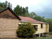
St Erney’s Homestead is located west of Wheatley Coast Road at the end of Parsons Road, approximately 2.28 km from the highway. Set in a pine forest clearing, the homestead is an unusual and aesthetically pleasing composition of two elements, a pise construction Federation Bungalow gable roof building with a later Group Settlement house of timber. At the time of construction in 1908-09 mud bricks were commonly used, while pise was a rarely used technique in the State. The walls are built up in stages with a footing and first stage of pise terminating at a sand and bitumen damp proof course. The upper walls are raised over the damp proof course in stages to plate height. The gable walls are framed with split jarrah shingle cladding. The roof to this section is painted galvanized corrugated iron with rolled ridges. The house has floors and ceilings of jarrah, with casement windows and framed ledge and braced doors. A timber framed lean-to carport is attached to the northern wall. A former Group Settlement timber house with an iron roof was added at the south side in 1945, opening to the original house via an existing door. This section is a rectangular plan, gable and hipped roof four-room building also in the Federation Bungalow style. The surrounding verandahs are partly filled in to provide a further two rooms. Windows to the filled in verandah are double hung sashes. The walls are lined with painted weatherboards. To the west of the main house is a timber framed former single men’s quarter, used for storage. The homestead is surrounded by plantation pines, with a single Monkey Puzzle Pine/Bunya Pine (Auracaria auracana) located just outside the fenced area to the north east. In the garden are some significant plants and trees, including some Pepper Trees, Apple, Lemon, Weeping Willow, Kurrajong and liquid amber.
St Erney’s Homestead is located in the Warren District which was first settled in the late 1850s and 1860s by pioneer families like the Muirs, Clarkes, Mottrams, Wheatleys and Blechyndens. After the Homestead Act was passed in 1893, allowing settlers to select a free homestead farm to a maximum of 160 acres, there was a new wave of European settlers to the district. In 1898 the railway reached Bridgetown . C1908-09 Thomas Harris Parsons took up land to farm with his wife and three sons in the Upper Warren district. They each took up a homestead block of 160 acres. Together they also took up 1,000 acres on Conditional purchase, selecting good country at the confluence of three tributaries of the Warren River. Thomas Parsons then built a homestead which was named St Erney’s after St Erney Church at Landrake, Cornwall, where his wife, Edith, had been christened in 1850. By 1910 three rooms had been built, with substantial walls of pise construction on a mixture of clay, sand and ironstone foundation. A verandah and the entrance were built on the north side and skillion rooms at the south. The veranda on the north side no longer exists, and the skillion rooms were removed to make way for additions in 1945. In 1910 the railway reached Manjimup, leading to further development in the surrounding district, including the Upper Warren District. In May 1917, following the death of Thomas Parsons, his wife, Edith took over possession of the farm. The Parsons family continued to work the farm with Harold Edward Parsons and his wife (formerly a Wheatley) and family occupying the homestead. Harold’s wife established and maintained a beautiful garden around the homestead . Edith Parsons died in June 1837 and the family continued to work the farm and live there. In 1945 major additions were carried out. The addition was formerly a 1930s timber framed group settler cottage, moved from a location in Northcliffe. Harold Parsons moved to Manjimup in the 1950s, but his son Stanley and his family continued to work the farm and live in the house until 1979. Records show that St Erney’s changed ownership in 1979, and in 1985 was taken over by the Conservator of Forests as part of the extension of the Forests Department pine planting programme in the South West. In August 1972 Stanley Parsons had requested that the place be assessed by the National Trust. The place was recorded by the Trust in Dec 1972 and much later, in August 1985, was classified by the National Trust. St Erney’s was entered on the Interim Register of the State Register of Heritage Places on 24 January 1994. On 10 July 1997, the place was included in the Shire of Manjimup Municipal Heritage Inventory. The place is no longer used as the homestead of a farm, but is tenanted as a house.
Integrity: Very Good Authenticity: Very Good
Fair
| Ref ID No | Ref Name | Ref Source | Ref Date |
|---|---|---|---|
| Heritage and Conservation Professionals: "Shire of Manjimup Municipal Heritage Inventory". | Shire of Manjimup | 1995 Adopted 1997 | |
| Heritage Council of WA Assessment | Heriateg Council WA | 2001 | |
| National Trust of Australia Assessment | National Trust of Australia WA |
| Owner | Category |
|---|---|
| CALM | State Gov't |
This information is provided voluntarily as a public service. The information provided is made available in good faith and is derived from sources believed to be reliable and accurate. However, the information is provided solely on the basis that readers will be responsible for making their own assessment of the matters discussed herein and are advised to verify all relevant representations, statements and information.
Wheatley Coast Rd Quinninup
Manjimup
South West
| Type | Status | Date | Documents |
|---|---|---|---|
| (no listings) |
| Type | Status | Date | Documents |
|---|---|---|---|
| (no listings) |
| Type | Status | Date | Grading/Management | |
|---|---|---|---|---|
| Category | ||||
| Municipal Inventory | Adopted | 28 Aug 2008 | Category C | |
Individual Building or Group
| Epoch | General | Specific |
|---|---|---|
| Original Use | FARMING\PASTORAL | Cottage |
This information is provided voluntarily as a public service. The information provided is made available in good faith and is derived from sources believed to be reliable and accurate. However, the information is provided solely on the basis that readers will be responsible for making their own assessment of the matters discussed herein and are advised to verify all relevant representations, statements and information.
Constructed from 1944
Representativeness, Aesthetic, Social and Historic
· Rows of small houses of similar design; · Uniform scale; · Rectangular structure; · Timber frame with weatherboard cladding; · Medium pitched gabled roof; · Corrugated iron roof; · Verandah across front elevation, under main roof ; · Timber flooring, posts and balustrading, and; · Timber window frames.
The Quinninup Mill Houses were associated with the second wave of settlers in the district in 1944. The Quinninup Mill Cottages are similar to those found in other mill towns in the Shire of Manjimup. Refer to Deanmill, North Ward and Pemberton Mill Workers Cottages, West Ward. Refer to 16.3 for more historical notes
Integrity: Good Authenticity: Good
Good
| Ref ID No | Ref Name | Ref Source | Ref Date |
|---|---|---|---|
| Internet site – Quinninup | 2005 | ||
| "Historical overview from Municiapl Inventory". | Shire of Manjimup | 2005 | |
| "Historical information in visitor shelter at Quinninup". | 2004 |
This information is provided voluntarily as a public service. The information provided is made available in good faith and is derived from sources believed to be reliable and accurate. However, the information is provided solely on the basis that readers will be responsible for making their own assessment of the matters discussed herein and are advised to verify all relevant representations, statements and information.
Wheatley Coast Rd Quinninup
Loc 3924
Manjimup
South West
Constructed from 1924
| Type | Status | Date | Documents |
|---|---|---|---|
| (no listings) |
| Type | Status | Date | Documents |
|---|---|---|---|
| (no listings) |
| Type | Status | Date | Grading/Management | |
|---|---|---|---|---|
| Category | ||||
| Municipal Inventory | Adopted | 28 Aug 2008 | Category C | |
Individual Building or Group
| Epoch | General | Specific |
|---|---|---|
| Original Use | EDUCATIONAL | Combined School |
| Type | General | Specific |
|---|---|---|
| Roof | METAL | Corrugated Iron |
This information is provided voluntarily as a public service. The information provided is made available in good faith and is derived from sources believed to be reliable and accurate. However, the information is provided solely on the basis that readers will be responsible for making their own assessment of the matters discussed herein and are advised to verify all relevant representations, statements and information.
Constructed from 1924
Representativeness, Aesthetic, Social and Historic
· Centrally located in Quinninup; · School complex is a composite of buildings, probably from different periods; · Earliest part built C1924; · Smaller section used for administrative functions; · Larger building located behind smaller building used for classrooms, and; · Rectangular building with pitched gabled roof of corrugated iron.
The Quinninup School has been an important part of community life in Quinninup since it was first established C1924. Quinninup was first settled as part of the Group Settlement Scheme devised by Premier James Mitchell in 1921. It was seen as a way to open up and settle the vast regions of the south-west of the state and also as a way to assist Britain by providing a livelihood for migrants in the years following the World War One. Quinninup Group 119 consisting of 17 families arrived in 1924. The school was built around this time. At the peak of the settlement scheme there were 40 families living around Quinninup. The Quinninup community has worked hard to maintain a strong community spirit over the years. Despite determined efforts from the community to save the school, it was the end of an era for the school in 2004, when it was closed owing to the low attendance numbers. Local children will have to attend school in Northcliffe or Manjimup. Refer to 16.3 for more historical notes
Integrity: Good Authenticity: Good
Good
| Ref ID No | Ref Name | Ref Source | Ref Date |
|---|---|---|---|
| Roper G (Principal): "Historical information". | Quinninup Primary School | 2004 |
| Owner | Category |
|---|---|
| Education Department | State Gov't |
This information is provided voluntarily as a public service. The information provided is made available in good faith and is derived from sources believed to be reliable and accurate. However, the information is provided solely on the basis that readers will be responsible for making their own assessment of the matters discussed herein and are advised to verify all relevant representations, statements and information.
Wheatley Coast Rd Quinninup
Lot 11
Manjimup
South West
Constructed from 1920
| Type | Status | Date | Documents |
|---|---|---|---|
| (no listings) |
| Type | Status | Date | Documents |
|---|---|---|---|
| (no listings) |
| Type | Status | Date | Grading/Management | |
|---|---|---|---|---|
| Category | ||||
| Municipal Inventory | Adopted | 28 Aug 2008 | Category C | |
| Municipal Inventory | Adopted | 28 Aug 2008 | Category C | |
Individual Building or Group
| Epoch | General | Specific |
|---|---|---|
| Original Use | COMMERCIAL | Hotel, Tavern or Inn |
| Type | General | Specific |
|---|---|---|
| Wall | TIMBER | Weatherboard |
| Roof | METAL | Zincalume |
| Roof | METAL | Steel |
This information is provided voluntarily as a public service. The information provided is made available in good faith and is derived from sources believed to be reliable and accurate. However, the information is provided solely on the basis that readers will be responsible for making their own assessment of the matters discussed herein and are advised to verify all relevant representations, statements and information.
Constructed from 1920
Representativeness, Aesthetic, Social and Historic
· The Tavern building consists of two sections; · One is either an addition, or two separate building have been colocated and joined; · Timber frame with painted weatherboard cladding; · Colourbond roof; · Verandahs on both sections – one of them enclosed with plastic screening, and; · Timber window frames.
The Quinninup Tavern has played a central role in the history of the Quinninup community over the past 75 years. In 1962 a fire destroyed the mill. It could have meant the end for Quinninup, but it was decided to rebuild the mill, using new and improved technology. The milling operations continued until 1982 when the Millars closed and sold the mill. The new owners Bunnings, sold off the fixtures and machinery. In 1986 the town was purchased by a single developer. The town was split up into title holdings and houses were sold as individual residences. Karri Lake Resort was built at this time. The Quinninup Tavern continues to be a popular meeting place and restaurant for locals and visitors to the area. Refer to 16.3 for more historical notes
Integrity: Good Authenticity: Good
Good
| Ref ID No | Ref Name | Ref Source | Ref Date |
|---|---|---|---|
| "Historical information in visitor shelter at Quinninup". | 2004 | ||
| Internet site – Quinninup | 2005 |
This information is provided voluntarily as a public service. The information provided is made available in good faith and is derived from sources believed to be reliable and accurate. However, the information is provided solely on the basis that readers will be responsible for making their own assessment of the matters discussed herein and are advised to verify all relevant representations, statements and information.