Local Government
Melville
Region
Metropolitan
69 Canning Beach Rd Applecross
Cnr Canning Hwy
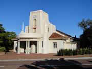
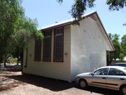
Tivoli Theatre
Melville
Metropolitan
Constructed from 1934 to 1952
| Type | Status | Date | Documents |
|---|---|---|---|
| Heritage List | Adopted | 16 Jun 2020 | |
| State Register | Registered | 05 Nov 1999 | HCWebsite.Listing+ListingDocument, HCWebsite.Listing+ListingDocument |
| Type | Status | Date | Documents |
|---|---|---|---|
| (no listings) |
| Type | Status | Date | Grading/Management | |
|---|---|---|---|---|
| Category | ||||
| Art Deco Significant Bldg Survey | Completed | 30 Jun 1994 | ||
| Classified by the National Trust | Classified | 06 Sep 1993 | ||
| Municipal Inventory | Adopted | 17 Jun 2014 | Category A | |
03926 Raffles Hotel Precinct
| Name | Type | Year From | Year To |
|---|---|---|---|
| Eales, Cohen & LBennett | Architect | - | - |
| Library Id | Title | Medium | Year Of Publication |
|---|---|---|---|
| 1264 | Applecross District Hall: Conservation Plan | Heritage Study {Cons'n Plan} | 1996 |
Individual Building or Group
| Epoch | General | Specific |
|---|---|---|
| Present Use | GOVERNMENTAL | Town, Shire or District Hall |
| Original Use | GOVERNMENTAL | Town, Shire or District Hall |
| Style |
|---|
| Inter-War Art Deco |
| Type | General | Specific |
|---|---|---|
| Wall | BRICK | Rendered Brick |
| Roof | TILE | Other Tile |
| General | Specific |
|---|---|
| SOCIAL & CIVIC ACTIVITIES | Sport, recreation & entertainment |
| DEMOGRAPHIC SETTLEMENT & MOBILITY | Settlements |
This information is provided voluntarily as a public service. The information provided is made available in good faith and is derived from sources believed to be reliable and accurate. However, the information is provided solely on the basis that readers will be responsible for making their own assessment of the matters discussed herein and are advised to verify all relevant representations, statements and information.
Constructed from 1952, Constructed from 1934
The Hall is significant for the following reasons: Aesthetic value: A fien example of Art Deco architecture acting as an entry statement for Applecross. Social Value: The building has been and continues to be a venue for local social and civic functions. Site of initial Roads Board meetings. Authenticity: Minor additions have been made along each side of the building otherwise it appears to be in it's original state. Historic Value: Represents some of the earlier influences of art deco architecture and was one of the first built in the style in Perth.
A rectangular plan form, a single-level building with prominent tower feature and projecting porch at the main entry; hipped roof form clad in Marseilles patter terracotta tiles.
The Applecross District Hall was constructed in 1934 to the design of W. M. Bennett, architectural partner in the firm Wales Cohen and Bennett. The architectural style reflects the popular fashion of the early 1930s, the Inter-War Art Deco style. The building is located on a prominent corner site close to Canning Highway and opposite the Raffles Hotel (1937) and the Canning Bridge (1937). The place reflects the residential suburban development of the Applecross locality in the 1930s and the provision of public building specifically designed for community gatherings and meetings. That use continues up to the present day.
Modifications: None Extent of Original Fabric: Most
Sound
| Name | Type | Year From | Year To |
|---|---|---|---|
| Eames, Cohen & Fitzhardinge | Architect | 1934 | - |
| Owner | Category |
|---|---|
| City of Melville | Local Gov't |
This information is provided voluntarily as a public service. The information provided is made available in good faith and is derived from sources believed to be reliable and accurate. However, the information is provided solely on the basis that readers will be responsible for making their own assessment of the matters discussed herein and are advised to verify all relevant representations, statements and information.
70 Canning Beach Rd Applecross
cnr Canning Hwy & Canning Beach Rd
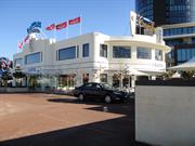
Canning Bridge Hotel
Melville
Metropolitan
Constructed from 1985, Constructed from 1896
| Type | Status | Date | Documents |
|---|---|---|---|
| Heritage List | Adopted | 16 Jun 2020 | |
| Heritage Agreement | YES | 30 Dec 2003 | HCWebsite.Listing+ListingDocument |
| State Register | Registered | 22 Jan 2002 | HCWebsite.Listing+ListingDocument, HCWebsite.Listing+ListingDocument |
| Type | Status | Date | Documents |
|---|---|---|---|
| (no listings) |
| Type | Status | Date | Grading/Management | |
|---|---|---|---|---|
| Category | ||||
| Municipal Inventory | Adopted | 17 Jun 2014 | Category A | |
| Art Deco Significant Bldg Survey | Completed | 30 Jun 1994 | ||
| Register of the National Estate | Identified Through State Process | |||
| Aboriginal Heritage Sites Register | Recorded | |||
| Classified by the National Trust | Classified | 14 Apr 1998 | ||
| Statewide Hotel Survey | Completed | 01 Nov 1997 | ||
| Register of the National Estate | Nominated | 28 Sep 2001 | ||
03926 Raffles Hotel Precinct
Sound condition however unsympathetic treatment to additions and renovations
| Name | Type | Year From | Year To |
|---|---|---|---|
| W G Bennett | Architect | - | - |
| Library Id | Title | Medium | Year Of Publication |
|---|---|---|---|
| 6714 | Raffles Hotel conservation plan. | Heritage Study {Cons'n Plan} | 2003 |
| 7756 | Raffles Hotel, Canning Bridge: submission to Heritage Council of Western Australia. | Heritage Study {Other} | 2006 |
| 6038 | Raffles Hotel (fmr Canning bridge Hotel) : assessment of authenticity & integrity. Revised edition. | Report | 1996 |
| 12129 | Raffles Hotel - conservation plan - interim draft report | Heritage Study {Cons'n Plan} | 2003 |
| 5790 | Raffles : development application report. | Report | 2002 |
| 1694 | Raffles architectural report for the Art Deco Society of WA Inc | Report | 1997 |
| 7545 | Raffles Hotel Specification : development comprising residential apartments and commercial building on Lots 176 and 177 (to be amalgamated) Nos 67 to 71 Canning Beach Road Appelcross, Western Australia. | Heritage Study {Other} | 2003 |
| 6091 | Raffles presentation December 2002. | C D Rom | 2002 |
| 6853 | Raffles Hotel Swan brand sign : archival record. | Archival Record | 2004 |
Individual Building or Group
| Epoch | General | Specific |
|---|---|---|
| Present Use | COMMERCIAL | Hotel, Tavern or Inn |
| Original Use | COMMERCIAL | Hotel, Tavern or Inn |
| Style |
|---|
| Inter-War Functionalist |
| Type | General | Specific |
|---|---|---|
| Wall | BRICK | Rendered Brick |
| Other | TIMBER | Other Timber |
| Other | METAL | Wrought Iron |
| Roof | METAL | Corrugated Iron |
| General | Specific |
|---|---|
| SOCIAL & CIVIC ACTIVITIES | Sport, recreation & entertainment |
This information is provided voluntarily as a public service. The information provided is made available in good faith and is derived from sources believed to be reliable and accurate. However, the information is provided solely on the basis that readers will be responsible for making their own assessment of the matters discussed herein and are advised to verify all relevant representations, statements and information.
Constructed from 1896, Constructed from 1985
The Raffle Hotel is significant for the following reasons: Aesthetic Value: The Art Deco additions complement the adjacent Applecross District Hall, the building is prominent and a well-known Melville landmark. Historic Value:The building is closely associated with the early development of Melville and in particular with road and river traffic at Canning bridge. It was the venue for the first meeting of the District Roads Board. Social Value: The Hotel has acted as a focal point for local activities as well as accommodating summer holiday makers. Authenticity: The building is marred by advertising structures, later additions and a lack od sympathy with the Art Deco style.
The initial western wing of the Canning Bridge Hotel (1896) comprises a single-storey Federation style rectangular brick building with clay tiled and gable roof. The 1937 eastern extension is a two-storey rendered and painted brick and concrete structure with a metal clad roof concealed behind the Art Deco style perimeter parapet. Both wings of the Hotel have been subjected to the substantial modification, particularly internally, to accommodate the community expectations over the lifetime of the buildings. Further modifications were carried out in c. 1985. The exterior of the eastern wing with its rooftop advertising is close in overall character to its 1937 presentation.
In summer, the Beeliar Nyoongars used the Raffles Hotel Site area as a campsite and hunting ground as this area was an abundant source of food for them. The present building evolved from the original 1896 Canning Bridge Hotel, which survives today as the Western wing, to the 1937 addition, the eastern wing, the dominant part of the Hotel. The 1937 addition demonstrates the practice in post-depression years whereby existing buildings were modernised and extended. The Hotel represents a continuous history of license premises since 1896 providing accommodation, utilities and entertainment to the community in a key location at the Canning River. The 1937 addition is indicative of the work of architect W. G. Bennett who was responsible for a major portfolio of residential houses, hotels and other community buildings. The Hotel continues to demonstrate in its various parts the changing aspirations for accommodation, entrainment, food and beverage as expected by the community in the lifetime of the building.
Modifications: Many Extent of Original Fabric: Some
Sound
| Name | Type | Year From | Year To |
|---|---|---|---|
| W G Bennett | Architect | - | - |
This information is provided voluntarily as a public service. The information provided is made available in good faith and is derived from sources believed to be reliable and accurate. However, the information is provided solely on the basis that readers will be responsible for making their own assessment of the matters discussed herein and are advised to verify all relevant representations, statements and information.
The Raff les Hotel1 is an example of the more restrained Art Deco or streamlined Inter-war Functionalist style2 used for commercial buildings and homes built in Perth during the later part of the 1930s. This was a style which was seen as progressive and modern and became increasingly popular in the years following the world-wide Depression. The building is prominently located near the Canning Bridge in Applecross, and takes good advantage of this site with its facades addressing the different vistas from the Canning Highway, Kintail Street, the Canning Bridge and the Canning River. (Figure 1) The exterior facades of the two storey building are cement rendered and painted white. It is designed on predominantly horizontal lines with sunk rustication. There is a central curved loggia to both floors flanked by straight sides on the east and west elevations. The window which encloses the central portico is a later add ition.3 The deeply recessed verandahs have also been filled with metal framed windows, with some being shaded by the addition of bull-nosed deck awnings to prevent solar gain. Apparently there had been extensive fire damage to the first floor which destroyed the original tiled roof. This was replaced by a metal deck roof which is concealed behind a parapet wall which rises in a ziggurat form above the entrances. Vertical fins to these parapet sections are typical Art Deco features which bear the word "Hotel". The name "Raffles" is incorporated into the facades using a 1930s typeface. Generally much of the exterior fabric of the 1937 structure remains intact. Additional components which are not part of this assessment include the two storey 1959 /60 additions behind the main building, the single storey 'Raffs' nightclub on the river side of the building (where the original beer garden was located) and the drive-in bottle shop. The roof line is also obscured by large advertising signage. According to an independent report there are visible remnants of the 1896 Canning Bridge Hotel: Inspection of the roof line revealed a corrugated galvanised iron roof, with ventilator grilles, partial chimney structure and small areas of exposed brick work at the wall head level. Original window openings are visible from the small external seating area, the window frames and sashes have been replaced with aluminium frame casements. The original window openings now illuminate the area occupied by the kitchen.4 The above mentioned report also provides information about the interior which has been extensively remodelled over time. Some of these changes are apparent particular reveals Bennett's awareness of particular modern contemporary design forms and the need for a building to address its site, especially one as prominent as the Raffles Hotel site which also provides an entry statement to Applecross and Melville. Rarity There are only a few examples of the Interwar Functionalist style of hotel, particularly of the free standing type, remaining in Perth. The Majestic and Scarborough Beach Hotels have been demolished, while the futures of the Coronado (1940, former Highway Hotel) in Claremont and the Swanbourne Hotel (1940) are in doubt. Other hotels from the period such as the Captain Stirling (1935) in Nedlands and the Criterion (1937) in central Perth demonstrate other inter-war styles such as the Mediterranean or Inter-War Free Classical. Representativeness The Raffles is a representative example of the Inter-war Functionalist style of architecture used during the latter part of the 1930s in Western Australia.
Assessment 1998 Construction Date: 1937 remodelling of 1896 Canning Bridge Hotel Alteration/Additions Date: Double storey extensions to rear 1959/60. Enclosure of verandah loggias with windows. Addition of a single storey wing c.1985. Signage on roof. The history of the general site that makes up the Canning Bridge area where the Raffles Hotel now stands can be traced to the early to mid 19th century when travellers and itinerant workers used this point to cross the Canning River by punt. Apparently the operator of this 'ferry' service was a somewhat difficult and unreliable person. "Representations to the Governor resulted in a rebuke to the operator for his slothfulness ..."8 The need for a bridge to take traffic from the eastern districts to the Port of Fremantle was realised in September 1849 "when a contract was let to Solomon Cook to build a timber bridge across the river."9 This was completed in January the following year and a toll system introduced. Apparently in that same year, on the 4th May 1850, a liquor licence was granted to a Samuel Duffield the owner of the "Bridge Inn".10 However the exact location of this inn has not been established and it cannot be assumed to be near the Canning Bridge. Apparently another bridge was constructed in 1867, and then by 1890-1the bridge was in such a bad state of repair that a third new bridge was constructed. In 1896 the Canning Bridge Hotel was constructed. At this time land south of the Swan River was being subdivided for residential development, although the district was to remain relatively undeveloped for many years to come. Another Canning bridge was to be built in 1908. The terms "inn" and "hotel" appear interchangeable in some accounts. For example, in his 1975 history of the City of Melville, Malcolm Uren follows his discussion about a new Canning Bridge (c.1896 according to his account) l l with reference to an "inn". An inn, referred to in some records as "a rowdy house", was built near the bridge and a garden was established on adjacent flats. A few pit sawyers had camps nearby and people came from Perth to hunt in the bush where there was plenty of game.12 Further on, Uren refers to a hotel which was, ... right in front of the jetty. It was a single storey structure with a high gabled roof that gave it the appearance of being a church. Between 1900 and 1906 it had been a gay place because people came from Perth to spend the Clay. A pavilion on the south side had a dance floor on the upper storey and that was usually crowded.13 Another history of Melville states: Since the days of the short-lived Leyson Arms Tavern at Bull's Creek in the 1830s, there were several unsuccessful a ttempts to establish a public house near the river on Canning Road. By 1900, however, the Canning Bridge Hotel, on the site of the present-day Raffles, had become a permanent landmark. It was single storey structure, with a high ablea roof. Beside it stood a pavilion, with a dance hall on the upper floor and refreshment rooms below . The older "Bridge Inn" may have been one of these "unsuccessful attempts to establish a public house". Apparently the Canning Bridge Hotel "changed hands with surprising frequency".15 During one particular year in 1904 when a Mr J.A. Bolton took possession, the Licensing Board refused to approve the transfer of the hotel license because although he "succeeded in attracting ferry loads of day visitors from Perth to his bars and Palais de Danse, he was unable or unwilling to control their raucous and disorderly behaviour.''16 This probably accounts for the above descriptions of the "inn" both as a "rowdy house" and "a gay place". The hotel not only became a popular place for day trippers from Perth, but it was also used by the W.A. Hunt Club as "a frequent rendezvous for the 'throw off '".17 (Figures 3 and 4) One "old time memory" recorded in Uren's history, mentions how the hotel "was at its busiest on Hunt Club days. The boys in the district welcomed those days because they were able to earn a little pocket money holding the horses of the huntsmen while they took refreshments. The hotel stables were located where the hall now stands."18 The Hotel was also used by the East Fremantle District Road Board for it's first council meeting on March 22nd, 1901.19 The Board (gazetted in June that year as the Melville Road Board) "had no staff, no office and they had to meet where they could secure a meeting place."20 Accounts of the area around the Canning Bridge Hotel during the early decades of this century describe it as an isolated place. "The only roads - they were little better than cleared tracks topped with shell - were Kintail, Ardross and Duncraig Roads. They ended suddenly in the bush. Canning Road was of limestone and was very rough to travel."21 The district was also described as "a children's paradise. There was swimming, boating, fishing, crabbing, prawning and rambles in the bush. Life was free and easy."22 This rural holiday ambience of the place was one of its main attractions for day trippers. There were improvements to the area in the late 1920s with Canning Road being "rehabilitated" and the hotel's "early popularity" "fully restored" when Mr and Mrs Arthur Bursey took over.23 At the beginning of the 1927-28 summer, Bursey advertised his premises as "a thoroughly up-to-date residential hotel and popular holiday resort," readily accessible by bus or ferry. The tariff was £2-2-0 per week or 8/- per day, and the cuisine excellent.24 The Hotel was also used for concerts and dances to raise funds for worthy causes, social and sporting events.25 The area also catered to other tastes with tea and refreshment rooms, such as the Canning Bridge Tea Rooms. There were rooms at Coffee Point (north of the Hotel) "for a brief period", and between The Esplanade and Kishorn Road.26 The histories of the Canning Bridge and the hotel developments appear to go hand in hand . In 1937 the Hotel underwent extensive remodelling and modernising to become the "Hotel Raffles", the name redolent of the famous Raff les in Singapore. At the same time a new Canning Bridge was being constructed, alongside the older one, which was completed in 1938. (See Figure 5) The successf ul tender for the hotel's modern face-lif t was submitted by Perth architect W .G. Bennett. Bennett, had been a partner of the firm Bales, Cohen & Bennett which was responsible for the nearby Applecross District Hall (now called the 'Tivoli') which was built in 1934. He left the firm in 1935.27 Although there is only three years difference between these two buildings, together they represent the stylistic shif ts that occurred in Western Austra lian buildings between the mid to late 1930s. The Hall is a fine example of the early 1930s Art Deco style with its emphasis on verticality, while the Raffles reveals the new design aesthetic of streamlined functional forms with an emphasis on horizontal lines. It could be argued that the two buildings represent a small but significant precinct of inter-war stylistic forms. Apart from the remodelling of the hotel, additions were also planned with the overall design being on 'horizontal lines'.28 The new Hotel Raffles was officially opened on December 10th, 1937. A report in The West Australian the following day described the event and the Hotel's special features: In the presence of 200 guests the Chief Secretary (Mr. W.H. Kitson) declared open the Hotel Raffles at Canning Bridge last night. The hotel which was reconstructed recently at a cost of nearly £10,000 is one of the most artistic and attractive hotels in the metropolitan area. A feature is a biergarten, which is believed to be the first of its kind in Australia. Mr Kitson said the premises would add greatly to the popularity of the Swan River and Canning Bridge. The surroundings generally were so delightful that it was difficult when in the hotel or biergarten to imagine that one was so near to Perth and the Swan and Canning Rivers. He congratulated the proprietors (Messrs. J.P. Monaghan and M.A. McDonnell) and the owner (Mr. J.A. Coleman) on the high standard of the establishment. During the evening supper, dancing and other entertainments were provided.29 The biergarten and the hotel's fittings were also described in the weekly trade journal Building and Construction. In this instance the biergarten was referred to as "Perth's first bier garten" and that "In design and in faithfulness of execution and fitments, it is claimed to be an exact reproduction of the traditional German Bier Garten." There were fif ty shade trees "including umbrella, plane, poplars, Kurragong and such like", and there was a "centre ornamental dove cote and aviary, sun dial, and rustic tables" and "a rustic arched gateway leads to the eastern side of the Hotel." (see Figure 5 dated c.1938 which shows the Hotel Raffles and its biergarten). What would appear to be a curious mixing of styles and ambiences such as the rustic nature of the German biergarten and the stream-lined modernity of the hotel design is continued in the interior where "a novel feature of the main lounge is an ingle fireplace", whereas the "whole design is intended to provide a tropical hotel in a metropolitan setting." The outstanding features of the "tropical lounge" included "specially designed" cane furnishings, large palms and pot plants. The basic colours of the lounge were green, Chinese red, cream and black.30 The concept of a tropical hotel may have been the reason for it being named the Raffles, however this connection is not made in the articles cited. Internally, the main lounge was 38 feet long and 36 feet wide, and the tropical lounge which featured a polished timber dance floor was 58 feet long and 26 feet wide. The two lounges were separated by folding glass doors. "The Saloon and Public Bars of the original Canning Bridge Hotel were increased in size, and finished with new textured walls, plaster ceilings, flush panelled walnut bar counters, with chromium edging and footrails, and chromium wall fittings and mirrors. The Dining Room, also situated in the original Canning Bridge Hotel, was redecorated with textured walls and a decorative plaster ceiling, and featured a new 14 feet long plate glass picture window, which overlooked the beer garden and river. A staircase, with wrought iron balustrade and polished maple handrail, led up to the new first floor, accommodating bedrooms, bathrooms, private lounge and two loggias (balconies). The Raffles quickly became a popular place for social entertainment, hosting the "Night in June" Ball and other society events."31 The post depression growth of the surrounding district could well be one of the reasons for the extensive remodelling and extension of the hotel. For example an advertisement placed in the Daily News has a drawing of "Raffles" and the caption "We welcome - Australia's most beautiful college to our district". (Figure 6)32 Calling itself "The Garden Hotel of the State", it makes reference to the fact that it is within a few minutes of Aquinas College (across the bridge in Salter Point), and Santa Maria Ladies' College in Attadale which was also constructed during 1937. Hotels such as the Raffles would have provided convenient places to stay for parents of country students boarding at these colleges, and country and other visitors coming to Perth. The Raffles would also have been a fashionable hotel for entertaining, as promoted in its advertisement, and being on the river, an ideal place for enjoying water sports and Perth's sunny Mediterranean climate. The hotel's deep shady balconies, a striking feature of the original design provided sweeping river views for those who preferred to relax out of the sun. The Hotel was also conveniently located on the recently upgraded Canning Highway (the former Fremantle Road which was renamed in 1937) which provided a direct route to the port city of Fremantle. During the mid-late 1930s the architect, William Bennett was responsible for the renovation of a number of existing hotels and the building of new hotels in styles fashionable at the time. These included remodelling the interior of the Savoy Hotel in Hay Street, Perth, the Esplanade Hotel and the exterior of the Bohemia (the last two have been demolished ), the Oxford Hotel, Leederville; Ocean Beach Hotel, Cottesloe, Scarborough Beach Hotel, Mt Barker Hotel and the Sawyer Valley Hotel. In 1959 further "motel-like" additions were made to the Raff les, for a projected sum of £30,000, which were anticipated to be completed by Christmas. "A double storey building will contain twenty rooms with accommodation for two or four in each. The plans for the additions were prepared by Dennis Smith Design Service and the building is being erected by Capitol Constructions."33 The following year another block of twenty units were constructed. "Typical of commercial architecture of the period, the motel blocks, located along the northern and eastern boundaries of the site, were constructed of brick, with shallow pitched metal deck roofs and aluminium window frames. A newspaper article of the time stated that the design of the new units did not match up with the existing hotel, because "the two are not close together"."34 "In the 1970s the hotel was modernised, a programme which included enclosure of the perimeter verandahs and balconies, removal of internal walls and parts of external walls (window ledges, etc.) and the replacement of most 1930s fixtures and fittings on the ground floor. A fire (date unknown) damaged much of the first floor and resulted in extensive repairs, including replacement of the hipped tiled roof with metal decking. A single storey addition was constructed, c.1985, to the east of the main building, in the area once occupied by the Bier garten. The addition which accommodates Raffs night club, has a decorative facade with horizontally banded cement render similar to the 1937 building, but the rear of the building has a standard column and beam structure and large metal framed windows."35 The Raffles has continued to be a well known and popular place for patrons to this day. According to a design submission for the redevelopment of the hotel and its site, dated 1995, the hotel "premises are licensed to cater for approximately 1510 people ... On average the Hotel attracts approximately 1000 people on a Saturday or Sunday during normal operating hours. On some occasions this figure can be exceeded.''36 Recent proposals to demolish the Raffles Hotel and develop the site have met with strong resistance from community action groups, in particular the Art Deco Society of WA. In 1998 the fate of the hotel is still very much in the balance.
This information is provided voluntarily as a public service. The information provided is made available in good faith and is derived from sources believed to be reliable and accurate. However, the information is provided solely on the basis that readers will be responsible for making their own assessment of the matters discussed herein and are advised to verify all relevant representations, statements and information.
Duncraig Rd, Point Heathcote Applecross
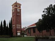
Inc: Administration Building, Canning House (fmr Female Ward), Murray House (fmr Male Ward), Swan House (fmr Treatment Block), the fmr kitchen, the clock/water tower, Duncraig House (fmr Nurse's Quarters), & encompassing the lower and upper lands of Point Heathcote
Point Heathcote Reception Home
Melville
Metropolitan
Constructed from 1929
| Type | Status | Date | Documents |
|---|---|---|---|
| Heritage Agreement | YES | 14 Jul 2004 | HCWebsite.Listing+ListingDocument |
| Heritage List | Adopted | 16 Jun 2020 | |
| State Register | Registered | 14 Jun 2021 | HCWebsite.Listing+ListingDocument, HCWebsite.Listing+ListingDocument |
| Type | Status | Date | Documents |
|---|---|---|---|
| (no listings) |
| Type | Status | Date | Grading/Management | |
|---|---|---|---|---|
| Category | ||||
| Classified by the National Trust | Classified | 06 Mar 1991 | ||
| Albany CGI-clad Houses Survey | Adopted | |||
| Aboriginal Heritage Sites Register | Interim | |||
| Art Deco Significant Bldg Survey | Completed | |||
| Municipal Inventory | Adopted | 17 Jun 2014 | Category A | |
Good.
| Name | Type | Year From | Year To |
|---|---|---|---|
| W B Hardwick | Architect | - | - |
| Library Id | Title | Medium | Year Of Publication |
|---|---|---|---|
| 7485 | Photographic and detailed record of Duncraig House. | Archival Record | 2005 |
| 3260 | Heathcote Hospital Complex : conservation plan Volumes 1 & 2 and Plan Volume. | Heritage Study {Cons'n Plan} | 1994 |
| 3990 | Heathcote Hospital, Applecross, WA : archival photographic documentation. | Photograph | 1999 |
| 5288 | Heathcote Hospital complex : conservation plan Volume 1. | Heritage Study {Cons'n Plan} | 1995 |
| 4949 | Duncraig House, Duncraig Road, Applecross : conservation plan / prepared for The Government Projects Office by Palassis Architects. | Heritage Study {Cons'n Plan} | 2000 |
| 5071 | Canning House, Heathcote : heritage assessment and conservation policy prepared for the City of Melville. April 2001. | Heritage Study {Other} | 2001 |
| 3897 | Specifications for the Landscape Works for Heathcote Playground, City of Melville | Report | 1998 |
| 2061 | Heathcote:a co ordinated assessment by the built environment landscape and historic sites committees of the National Trust of Australia(1991) | Report | 1991 |
| 3898 | Architectural Specification for the Refurbishment and Redevelopment of the Heathcote Precinct at Duncraig Road Applecross for the Government Property Office and the City of Melville | Report | 1998 |
| 5728 | Heathcote Hospital Complex, Applecross : conservation plan. | Heritage Study {Cons'n Plan} | 1994 |
Individual Building or Group
| Epoch | General | Specific |
|---|---|---|
| Present Use | RESIDENTIAL | Institutional Housing |
| Original Use | HEALTH | Office or Administration Bldg |
| Original Use | HEALTH | Hospital |
| Present Use | HEALTH | Hospital |
| Original Use | HEALTH | Housing or Quarters |
| Present Use | EDUCATIONAL | Museum |
| Original Use | HEALTH | Asylum |
| Present Use | RESIDENTIAL | Single storey residence |
| Style |
|---|
| Inter-War California Bungalow |
| Type | General | Specific |
|---|---|---|
| Wall | BRICK | Common Brick |
| Roof | TILE | Terracotta Tile |
| General | Specific |
|---|---|
| DEMOGRAPHIC SETTLEMENT & MOBILITY | Exploration & surveying |
| SOCIAL & CIVIC ACTIVITIES | Institutions |
| SOCIAL & CIVIC ACTIVITIES | Community services & utilities |
| PEOPLE | Early settlers |
| PEOPLE | Aboriginal people |
This information is provided voluntarily as a public service. The information provided is made available in good faith and is derived from sources believed to be reliable and accurate. However, the information is provided solely on the basis that readers will be responsible for making their own assessment of the matters discussed herein and are advised to verify all relevant representations, statements and information.
Constructed from 1929
Heathcote Hospital is significant on the following grounds: Aesthetic Value: A cohesive group of buildings with a clock tower highlighting it's prominent position on the foreshore. Social Value: The choice of the site was made on the basis that its attractive environment would be therapeutic for the patients. Authenticity: The buildings are intact. Historic Value: Site named after midshipman Heathcote who was a member of Stirling's exploration party up the Swan River. Considered as possible site for the capital city for the infant colony in 1829.
The original buildings, with the exception of the Nurses’ Quarters and the Water Tower, are single-storey and constructed in red brickwork with hipped terra cotta tiled roofs. Joinery is timber painted white, with windows generally in six-light balance-hung sashes. Verandas are provided to shelter the interiors, to act as transitional spaces between indoors and outdoors, and as useful spaces for the residents. Decoration, where it does occur, is constrained. There is no decorative woodwork except to timber brackets supporting hoods to the projecting pavilion of the earliest buildings. Flush solider courses, in face brick walls above and below openings, simple projecting courses to chimneys, arched motifs to the parapets of central pavilions and ventilation cupolas on the centre point of the roof to the earlier buildings, provide the only decorative relief to what is otherwise a simple pallet of single-storey, restrained, domestic buildings for residential and administrative use. The Kitchen Block is faithful to the same architectural vocabulary, and includes a functional glazed roof-light over the central space. The style of the earliest buildings is undistinguished, demonstrating a progression of building form which development out of a rejection of the exuberance of the Edwardian and Federation style through the economics of modernism and the Wars. These buildings are representative of institutional design in the 1920s and 1930s. The architectural merit of the earlier buildings derives from their consistency of materials and elements in the context of a garden environment. Notwithstanding the abuses to which some buildings have been subjected, they provide externally, through the use of verandas and garden spaces between and around buildings, an ambiance which is commendable and not to be found in the more recent buildings dating from the 1960s. The Water Tower is a landmark building, critical to the overall development and distinguishable from spaces between buildings on the site as well as from vistas across the river. This Tower is a masterly piece of design and a rare element of significance in the architectural development of the Hospital. The more recent buildings vary substantially in architectural character from the original buildings and from each other. They present no significant architectural or environmental character, but identify as deterioration in the built environment of the Hospital. The original Nurses’ Quarters on the southern periphery of the Hospital are a two-storey red brick building, sympathetic in character with the Hospital buildings. A modern addition detracts from the simple and representative character of the original building. The Nurses’ Quarters are not included in Heathcote.
Prior to European settlement, the Heathcote area was known by the indigenous Beeliar people as “Kooyagoordup” – the place of the “Kooya”, a species of frog – as permanent lookout, fishing and camping ground. From the 1840s, Point Heathcote was used for grazing horses and cattle. In the 1890s, Alexander Matheson subdivided the surrounding area for residential development with the Point remaining as original bushland. Point Heathcote was one of the landing and cap sites of Captain James Stirling during his exploration of the Swan River in 1827. His intention was to assess the potential of the district for settlement. At this time, although there was no subsequent report of its condition, a garden was planted at the site to assess soil productivity. This was one of several experimental plantings made by the party of whom the Colonial Government botanist, Charles Fraser, was a member. Point Heathcote was named after Midshipman G. C Heathcote, said to have been the first European to land there. Following the decision to establish a Colony of free settlers, Point Heathcote was favourably considered as the site of capital city in 1829. However, Stirling explained to the Permanent Under Secretary for the Colonies, R. W. Hay, he had chosen the Perth site as it was well timbered, had good water and better facilitated communication between the capital and both agriculturalists on the Upper Swan and commercial interests at the port of Fremantle. The Point Heathcote Reception Centre was designed in 1926 under the direction of W. B. Hardwick, the Government Architect. The Centre, situated on twenty-three acres of land at the junction of the Swan and Canning Rivers was commenced departmentally in 1926-27 and provided for seventy-six patients, thirty-eight of each sex. The need for a new facility had arisen due to the conditions at Claremont, where overcrowding, the enclosed surroundings and the increasing number of patients had rendered Claremont unsuitable for all cases of mental ill-health. A section of the Lunacy Act allowed for voluntary patients, but this section was seldom used, as patients did not volunteer to enter an institution such as Claremont. In 1924, after a report on the inadequacies of facilities, it was decided that a new reception centre should be provided. Eight hectares of land had been purchased from the Catholic Church in 1923 for this purpose. The Christian Brothers had secured the land in 1918 with the intention of establishing a boy’s school, using the land until 1923 as a holiday retreat. Heathcote was described as a ‘home for the reception of recoverable patients, and not for senile, epileptic, or mentally deficient patients’. Thus the use of Heathcote for recoverable patients implied that those who went to Claremont were not recoverable, and this policy had a bad effect on Claremont for some fifty years. The Water Tower (now Clock Tower) was designed in 1928, by Principal Architect Tait, successor to Hardwick. Point Heathcote Reception Home was completed by early 1929. The official opening ceremony was conducted by the Lieutenant-Governor, Sir Robert McMillan, on 22nd February, 1929. A new treatment block (Swan house) was added in 1940, for a further twenty-six patients, designed by the Government Architect, A. E. Clare, and marked a change in the style and pattern of development. More recent buildings, dating from 22nd February 1962 include Avon House (1972), the Occupational Therapy Buildings and the Hall. These have had different programmatic requirements due to changes in the nature of the services provided by Heathcote. Post-war development did not attempt to reflect the style, character, typology or site planning principles of the earlier development. Heathcote finally closed in 1994 and discussions began in 1997 between Government and the City of Melville to restore the place and use the site for community purposes.
Modifications: Some Extent of Original Fabric: Much
Sound
| Name | Type | Year From | Year To |
|---|---|---|---|
| W B Hardwick | Architect | 1929 | - |
| Owner | Category |
|---|---|
| City of Melville | Local Gov't |
This information is provided voluntarily as a public service. The information provided is made available in good faith and is derived from sources believed to be reliable and accurate. However, the information is provided solely on the basis that readers will be responsible for making their own assessment of the matters discussed herein and are advised to verify all relevant representations, statements and information.
Point Heathcote is a landmark site which at various times figured prominently in the history of Perth from the time of Captain Stirlings expedition of 1827 through Aboriginal European relationships during the colonial period, recognition of its physical significance by the City Beautiful movement to is choice as the site for the Point Heathcote Reception Home. Point_Heathcote is a sominant headland marking the south-eastern corner_ of Melville Waters and the junction' of the Swan and Canning Rivers. It is an important reference and identification Point because of its location and identity. A consistent historical objective has been for point Heathcote to become the southern foreshore equivalent of Kings Park with the retention of the essential physical form and vegetation of the headland. Despite alterations, the original group of buildings developed in 1929' as the Point Heathcote_ Reception Home a cohesive complex which show a careful and sensitive use of an exceptional site for the development of a Psychiatric- hospital based on a new typology of buildings and external spaces. These mark an important advancement on earlier institutions for the treatment of mental health within Western Australia; Heathcote occupies the important Point Heathcote site with distinction because the natural characteristics of the site are enhanced by an original complex which adds a sympathetic civic presence to the totography and landscape quality-of the promontory: The water Tower is an important landmark; which also a conscious civic compliment to the Winthrop Hall campanile in the University of Western Australia. The happy congruence of this important site and the original Point Heathcote Reception Home are identified in the public mind as an important civic place and landmark which should be retained.
The male portion fronted onto the Canning River and the female portion onto the Swan River. Each block was provided with verandahs, balconies/ and hot and cold water. The administration block stood between connected to the ward blocks by covered ways. The kitchen block was centrally situated with regard to the future layout. Cold storage facilities and boiler house were attached. The domestic quarters were adjacent to the kitchen and the two storey nurses quarters which provided for a staff of 36, was near the western boundary of the site facing Waylen Bay. Provision was made for tennis courts and other sporting facilities . The Water Tower cum Clock Tower was designed in 1928 by Principal Architect Tait (successor to-Hardwick):-to render the “utilities inconspicuous and improving the whole appearance of the Institution, would be justified and very well spent “ The additional 700 pounds provided a landmark tower. The treatment block (Swan House) added in 1940, to the design of the Government Architect/ A E Clare/ marked a change in the style and pattern of development; The scale and character of this block are similar to-that-of the,.ori9inal home development, however the typology of buildings and spaces was changed. It seems probable that the Medical Officer s Residence was constructed at this time, given the strong stylistic similarities with Swan House . More recent buildings- dating from 22 February 1962 and 1960-s include, Avon House 1972, the Occupational Therapy Building and Hall. These have had different programmatic requirements due to changes in the nature of the services provided by Heathcote. Post War development did not attempt to reflect the style character, typology or site planning principles of the earlier development. Both internally and externally the original home development was methodically and-rationally planned with a clear building typology applied. This/in time, was translated into a rationalised construction process using traditional methods, utilising modular materials and consistency of detailing to give order and character. Care was also taken to modify climatic/environmental factors for those parts of the original home which would otherwise suffer discomfort due to room orientation. Spaces Site planning principles for the original home were for a series of pavilions/blocks to be disposed around a central communal courtyard/ through which all communication occurred. This was reached through a sweeping, welcoming drive through grand entrance gates, flanked by palm trees. Patients accommodation was disposed into wings providing the opportunity for patients discreet external spaces. Nursing quarters were removed into the western corner of the site/ with their own discreet section of the foreshore and separate entrance from Duncraig Road. The Water Tower, kitchen and former domestic quarters were symmetrically aligned in the centre of the site. The pattern and hierarchy of external spaces/ which was integral to the typology of the original building types was not respected in later editions. This has confused the original design intentions and diminished the value of the original home desi gn d. The number and variety of the external spaces in the original typology provided wide possibilities for their use from communal spaces to quiet reflective spaces-for small numbers of people. Whilst these possibilities still exist/ because of the nature of the site. The clear hierarchal pattern has been substantially compromised by the Post War development.
Assessment 1991 Lionel Lukin was the first owner of the site when he was granted the 300 hectare Swan Location 61 which was later extended to 400 hectares. On visiting the land he was disappointed, considering only 8 out- of 300 hectares were suitable for arable farming. In December 1832 Lukin exchanged Lot 61 for 20 hectares adjacent to his Fremantle property claiming that due to the number of Aborigines on the site no one would settle there. He gained freehold ownership in 1841 but it was September 1843 before properties were marked out. After Lukin mortgaged the Property and fail to meet repayments Swan Location 61 was bought at auction in September 1842 by Alfred Waylen. In 1842 it had been mortgaged to Peter Belches of Albany. John Wellard bought Swan Location 61 from Waylen in 1856 _for 700 pounds, planning to use the land for grazing. He had a butchers shop at Fremantle and, provided meat for the Rottnest penal settlement . In 1865 he was declared bankrupt and Lots 61and 74 were purchased by Silas and George Pearse for 250 pounds. The Fremantle butchers and merchants had the contract for the supply of fresh meat to-Rottnest and owned a tannery at North Fremantle. Between 1840 and 1885 the property was used as rough grazing-for horses and cattle. William McMillan bought the land in 1886 and sold it to the Western Australian Land-Company Ltd in 1892. Alexander Matheson bought Swan Location 61 and nearby Swan Locations 73 and 74; and the Cockburn Sound Location 356 which were subdivided in 1896 by the Melville Water Park Estate Company of which he was a director. The new suburb of Applecross was planned as a model suburb for wealthy residents but did not really take off until the 1920 s. The site at the tip of Point Heathcote encompassing most of the hospital site was transferred to Matheson s wife, Eleanor, at the time of the original subdivision. In 1909 the Christian Brothers first showed interest in acquiring the land but were not successful in obtaining it until-1918. Between 1923 and 1927, the area of the present Point Heathcote Hospital was bought by the government including the land held by the Christian Brothers and smaller lots owned by the London and Western Australian Investment Co Ltd, Harold Redcliffe (Lot 34) and N S Bartlett(Lot~33).
This information is provided voluntarily as a public service. The information provided is made available in good faith and is derived from sources believed to be reliable and accurate. However, the information is provided solely on the basis that readers will be responsible for making their own assessment of the matters discussed herein and are advised to verify all relevant representations, statements and information.
65 Kintail Rd Applecross
Melville
Metropolitan
Constructed from 1913
| Type | Status | Date | Documents |
|---|---|---|---|
| Heritage List | Adopted | 16 Jun 2020 | |
| State Register | Registered | 15 Dec 1995 | HCWebsite.Listing+ListingDocument, HCWebsite.Listing+ListingDocument |
| Type | Status | Date | Documents |
|---|---|---|---|
| (no listings) |
| Type | Status | Date | Grading/Management | |
|---|---|---|---|---|
| Category | ||||
| Register of the National Estate | Registered | 14 May 1991 | ||
| Register of the National Estate | Nominated | 15 Oct 1984 | ||
| Classified by the National Trust | Classified | 05 Jun 1984 | ||
| Municipal Inventory | Adopted | 17 Jun 2014 | Category A | |
The weatherboard buildings, which formed the original Applecross State School and Head Teacher's Quarters, were erected by Aitkens and Tillotson for the Western Australian Public Works Department in 1913. The buildings are both constructed of timber with corrugated iron roofs. The Teacher's Quarters originally consisted of three rooms with a verandah at the front and back, a bathroom being included on the latter. Another room was added and the verandah extended in 1920. Otherwise the house has been little altered and is still used by the school for extra-currricular activities. Apart from installation of a Wonderheat in the fireplace and removal of the raised platform for the teacher, the school is unchanged. It was supplemented in 1918, as school numbers grew, by a pavilion classroom of timber and canvas but this structure has not survived. The weatherboard schoolroom served as the school proper until a brick building, which became the nucleus of the new school, was completed in 1945. After that time it served as an ordinary classroom for several years before becoming a general storeroom. In 1979 the schoolroom was refurbished with school items donated by the public to represent the original one teacher school. The schoolroom was re-opened by the Director-General of Education in 1980 and is a focus of interest for both school and parents with ongoing education value for both teachers and students.
| Name | Type | Year From | Year To |
|---|---|---|---|
| Aitkens & Tillotson | Architect | - | - |
| Public Works Department | Architect | - | - |
| Library Id | Title | Medium | Year Of Publication |
|---|---|---|---|
| 1462 | Applecross Primary School original buildings : conservation plan. | Heritage Study {Cons'n Plan} | 1996 |
Individual Building or Group
| Epoch | General | Specific |
|---|---|---|
| Original Use | EDUCATIONAL | Primary School |
| Present Use | EDUCATIONAL | Museum |
| Original Use | EDUCATIONAL | Housing or Quarters |
| Type | General | Specific |
|---|---|---|
| Roof | METAL | Corrugated Iron |
| Wall | TIMBER | Weatherboard |
| General | Specific |
|---|---|
| SOCIAL & CIVIC ACTIVITIES | Education & science |
This information is provided voluntarily as a public service. The information provided is made available in good faith and is derived from sources believed to be reliable and accurate. However, the information is provided solely on the basis that readers will be responsible for making their own assessment of the matters discussed herein and are advised to verify all relevant representations, statements and information.
Constructed from 1948, Constructed from 1913
Applecross Primary School os significant for the following reasons: Historic Value: The building was one of the first purpose built schools in Applecross and is in close proximity to the newer Applecross Primary School (within the grounds) which replaced it. Social Value: The building as a school Museum provides an insight into what this aspect of life was like in the early days of settlement. Authenticity: The building is in its original state.
The School building, the Teachers House and the Shelter Shed are timber-framed clad in lapped timber boarding, painted with pitched and gabled roofing clad in corrugated iron sheeting. Joinery and floors throughout are timber. The Shelter Shed has no windows and is now enclosed as workshop and store. The Bell Tower is a freestanding stepped structure of precast concrete blocks, painted, with a metal bracket and bell mounted on top. A brass plaque on the structure of precast concrete blocks, painted with a metal bracket and bell mounted on top. A brass plaque on the structure reads: “Western Australian Centenary 1829-1929. Presented by Parents and Citizens”. The Bell Tower dates from 1929. The Pavilion is the junction of two individual single pavilion classrooms constructed in 1919 and 1948. The now single building is timber-framed with painted lapped timber-boarded dado, fibrocement linings above the dado, timber floors and pitched roof clad in corrugated galvanised iron sheeting.
Applecross was still a small suburb at the turn of the century, with poor roads leading to the nearest school, 4 1/2 miles away. However, there were more than a dozen children in the area needing an education. Discussion with the Education Department about the issue led to the first Applecross School opening in 1905, and run from the local Road Board Hall as there were not enough pupils to warrant a school being built. By 1909, the Hall was in a poor state of repair, and terribly hot in summer, but despite the complaints of parents, the Education Department would still not build a new school, as there was not a large enough attendance. Gradual increases in the numbers of pupils meant that the Hall was becoming increasingly crowded, and the complaints to the Department of Education increased accordingly. Consequently the Department began looking for a suitable piece of land on which to build a school 1912. In order to speed up the process, the Land Agents in the area offered the Department Lots 304-311 for free, providing the new school was built within 6 months. However, by the start of the school year in 1913, the school was not even started, and so a letter by the Land Agents requesting the starting and completion dates for the school building was sent out to the Department in May. At the beginning of June the contract to build the one-room school was given to Messrs. Aitkens and Tillotson of Perth, to be completed on 3rd September at a cost of 783 pounds 18s 6d. The school was opened on the 4th September 1913. As the suburb grew, so too did the school, and by 1918 the new school was already overcrowded, with 57 children on the roll, but the room designed for 50. A second classroom was built soon after, and by 1934 there were still only the two classrooms, but a shelter shed was also being used as a classroom. The Bell Tower was constructed and erected in 1929, in celebration of the Western Australian Centenary 1829-1929 and to house the School bell. The first of the brick classrooms were built in 1945 to alleviate crowding. The ‘baby boom’ era of the late 1940s and early 1950s was a period of tremendous growth in the Applecross area, and consequently the numbers of children attending the school increased dramatically. In 1948 the enrolment at the school was 178 students, and by 1950 it had nearly double to 310. Unfortunately, in the opinion of the School Inspectors of the day, the old wooden buildings were ‘badly in need of general renovation’, but still had to be used because of the overcrowding. In the next few years, classes were place din temporary rooms, in the staff room, in the hall, even in the cloakroom for extra space. More new brick classrooms were added in 1948, 1954 and 1959. When the additions were made in 1954, the old wooden 1913 school room was moved to its present position to make space. The school reached its peak of 843 pupils in 1962, and steadily decreased after that, so that by 1970 the three timber-frame classrooms (all separate from the main school block) were not regularly occupied. In 1978, a student teacher at the school suggested that the 1913 original building be restored and then used as an example of a one-teacher school. By the 1970s, the room had been used for nothing more than a storeroom, so the suggestion was seen as a good use of the old school building. The teacher Mrs Susan Clark who made the suggestion, with the aid of other helpers, cleaned and restored the room and it was opened in May 1980. Since then the school room has been made available to teachers so that classes can be taken through and shown what school life was like at the beginning of this century.
Modifications: Very Few or None Extent of Original Fabric: Most
Sound, some deterioration of paint finishes.
| Name | Type | Year From | Year To |
|---|---|---|---|
| PWD | Architect | 1913 | - |
| Owner | Category |
|---|---|
| Education Department | State Gov't |
This information is provided voluntarily as a public service. The information provided is made available in good faith and is derived from sources believed to be reliable and accurate. However, the information is provided solely on the basis that readers will be responsible for making their own assessment of the matters discussed herein and are advised to verify all relevant representations, statements and information.
A typical one-teacher school of its period, with adjacent teacher's house, these two buildings are of historical importance as the first school in the area and the centre of education for its children, until the first of the nearby brick buildings was completed in 1945. The original schoolroom was re-furbished with authentic items in 1979 and is now used to demonstrate to the children of today an earlier way of life. The weatherboard construction of both houses and schoolroom is of interest.
The buildings were erected by Aitkens and Tillotson for the P.W.D. in 1913 and are of timber with corrugated iron roofs. The total costs being £795/10/6. The quarters consisted originally of three rooms with verandahs front and back, a bathroom being included on the latter. Another room was added and the verandah extended in 1920 but otherwise the house has been little altered and is used by the school for extra-curricular activities. Apart from installation of a wonderheat in the fireplace and the removal of the raised platform for the teacher the school is unchanged. It was supplemented, as school numbers grew, by a pavilion classroom of timber and canvas and a brick shed, also used for classes but those two structures have not survived. The re-furburbished schoolroom was opened by the Director General of Eduction in 1980 and is a focus of interest for both the school and the parents.
Assessment 1984 Construction 1913
This information is provided voluntarily as a public service. The information provided is made available in good faith and is derived from sources believed to be reliable and accurate. However, the information is provided solely on the basis that readers will be responsible for making their own assessment of the matters discussed herein and are advised to verify all relevant representations, statements and information.
65 Kintail Rd Applecross
Registered as part of parent 01542
Centenary Bell Tower - Applecross Primary Sch
Melville
Metropolitan
Constructed from 1929
| Type | Status | Date | Documents |
|---|---|---|---|
| (no listings) |
| Type | Status | Date | Documents |
|---|---|---|---|
| (no listings) |
| Type | Status | Date | Grading/Management | |
|---|---|---|---|---|
| Category | ||||
| (no listings) | ||||
01542 Applecross Primary School (original buildings)
Historic site
| Epoch | General | Specific |
|---|---|---|
| Original Use | EDUCATIONAL | Other |
| Present Use | VACANT\UNUSED | Vacant\Unused |
| Type | General | Specific |
|---|---|---|
| Wall | CONCRETE | Concrete Block |
| General | Specific |
|---|---|
| SOCIAL & CIVIC ACTIVITIES | Education & science |
This information is provided voluntarily as a public service. The information provided is made available in good faith and is derived from sources believed to be reliable and accurate. However, the information is provided solely on the basis that readers will be responsible for making their own assessment of the matters discussed herein and are advised to verify all relevant representations, statements and information.
65 Kintail Rd Applecross
Registered as part of parent 01542.
Melville
Metropolitan
Constructed from 1948, Constructed from 1919
| Type | Status | Date | Documents |
|---|---|---|---|
| (no listings) |
| Type | Status | Date | Documents |
|---|---|---|---|
| (no listings) |
| Type | Status | Date | Grading/Management | |
|---|---|---|---|---|
| Category | ||||
| (no listings) | ||||
01542 Applecross Primary School (original buildings)
Individual Building or Group
| Epoch | General | Specific |
|---|---|---|
| Original Use | EDUCATIONAL | Primary School |
| Present Use | EDUCATIONAL | Primary School |
| Type | General | Specific |
|---|---|---|
| Wall | ASBESTOS | Fibrous Cement, flat |
| Wall | TIMBER | Weatherboard |
| Roof | METAL | Corrugated Iron |
| General | Specific |
|---|---|
| SOCIAL & CIVIC ACTIVITIES | Education & science |
This information is provided voluntarily as a public service. The information provided is made available in good faith and is derived from sources believed to be reliable and accurate. However, the information is provided solely on the basis that readers will be responsible for making their own assessment of the matters discussed herein and are advised to verify all relevant representations, statements and information.
65 Kintail Rd Applecross
Registered as part of parent 01542.
Melville
Metropolitan
Constructed from 1945 to 1959
| Type | Status | Date | Documents |
|---|---|---|---|
| (no listings) |
| Type | Status | Date | Documents |
|---|---|---|---|
| (no listings) |
| Type | Status | Date | Grading/Management | |
|---|---|---|---|---|
| Category | ||||
| (no listings) | ||||
01542 Applecross Primary School (original buildings)
Individual Building or Group
| Epoch | General | Specific |
|---|---|---|
| Original Use | EDUCATIONAL | Primary School |
| Present Use | EDUCATIONAL | Primary School |
| Type | General | Specific |
|---|---|---|
| Roof | TILE | Terracotta Tile |
| Wall | BRICK | Common Brick |
| General | Specific |
|---|---|
| SOCIAL & CIVIC ACTIVITIES | Education & science |
| DEMOGRAPHIC SETTLEMENT & MOBILITY | Government policy |
This information is provided voluntarily as a public service. The information provided is made available in good faith and is derived from sources believed to be reliable and accurate. However, the information is provided solely on the basis that readers will be responsible for making their own assessment of the matters discussed herein and are advised to verify all relevant representations, statements and information.
Canning Hwy Applecross and Como
Also is part of P3926 Raffles Hotel Precinct.
Canning Bridge northbound/downstream
MRWA No. 913
Melville
Metropolitan
Constructed from 1938
| Type | Status | Date | Documents |
|---|---|---|---|
| (no listings) |
| Type | Status | Date | Documents |
|---|---|---|---|
| (no listings) |
| Type | Status | Date | Grading/Management | |
|---|---|---|---|---|
| Category | ||||
| Art Deco Significant Bldg Survey | Completed | 30 Jun 1994 | ||
| Statewide Lge Timber Str Survey | Completed | 11 Dec 1998 | ||
16178 Canning Bridge
| Name | Type | Year From | Year To |
|---|---|---|---|
| E.W Godfrey, Public Works Department | Architect | - | - |
| Library Id | Title | Medium | Year Of Publication |
|---|---|---|---|
| 3174 | Western Roads : history of timber bridges in Western Australia. | Report | 1979 |
Historic site
| Epoch | General | Specific |
|---|---|---|
| Present Use | Transport\Communications | Road: Bridge |
| Original Use | Transport\Communications | Road: Bridge |
| Style |
|---|
| Other Style |
| General | Specific |
|---|---|
| TRANSPORT & COMMUNICATIONS | Road transport |
This information is provided voluntarily as a public service. The information provided is made available in good faith and is derived from sources believed to be reliable and accurate. However, the information is provided solely on the basis that readers will be responsible for making their own assessment of the matters discussed herein and are advised to verify all relevant representations, statements and information.
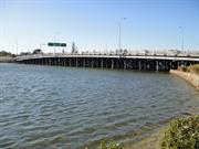
Canning Hwy over the Canning River, between Applecross and Como Applecross and Como
Includes both bridges
Eastbound Downstream, ref 913
Westbound Upstream, ref 912
Melville
Metropolitan
Constructed from 1958, Constructed from 1937, Constructed from 1849 to 1869
| Type | Status | Date | Documents |
|---|---|---|---|
| Heritage List | Adopted | 16 Jun 2020 | |
| Heritage List | Adopted | 14 Nov 2000 | |
| State Register | Registered | 02 Mar 2012 | HCWebsite.Listing+ListingDocument, HCWebsite.Listing+ListingDocument |
| Type | Status | Date | Documents |
|---|---|---|---|
| (no listings) |
| Type | Status | Date | Grading/Management | |
|---|---|---|---|---|
| Category | ||||
| Municipal Inventory | Adopted | 17 Jun 2014 | Category A | |
| Local Heritage Survey | Adopted | 25 Mar 2003 | Category A | |
Reports during the 1862 floods observed Canning Bridge being ‘gradually swept away’, with ‘only a portion of the centre remaining’ and the approaches completely lost.[1] However, less than three months later the bridge was reported as being ‘in a sufficient state of repair for all the purposes of ordinary traffic’.[2] In 1866, convicts were involved in repairs to both the bridge and its southern approaches.[3] Heritage documents in the 2000s claimed a replacement bridge was built by convicts in 1867, but searches of 1860s newspapers found no record of the bridge being replaced. Possibly works in 1869 to construct Upper Canning Bridge (Perth-Albany Road, Gosnells) have been confused with the Lower Canning site on the Perth-Fremantle Road.[4] Alternately, the ‘repairs’ of 1862 or 1866 may have been a complete reconstruction that was underreported. Canning Bridge was closed for some 18 months from early 1872 after a fire, rumoured to have been lit by fishermen, destroyed two central bays. The government offered £5 reward for information leading to conviction of those responsible. Winter floods caused further damage. The ‘reconstructed’ bridge reopened in 1873.[5] It is likely this ‘reconstruction’ was in later years remembered as a completely new bridge. The bridge that remained in 1892 (when a raised navigation span was added) was approximately 50ft longer than the one known to have been built in 1849,[6] supporting notions that it was not the original bridge (although, as the approaches were lost in the 1862 floods, it is possible that repairs included lengthening the bridge). As Fremantle Roads Board repeatedly invited tenders in 1872 and 1873 for the reconstruction work,[7] it is unlikely that convicts were involved. [1] Inquirer and Commercial News, 23 July 1862, p.4, https://trove.nla.gov.au/newspaper/article/69135805/6578395 [2] Perth Gazette and Independent Journal of Politics and News, 3 October 1862, p.3, https://trove.nla.gov.au/newspaper/article/2934069 [3] (no author), ‘Public Works’, Inquirer and Commercial News, 4 July 1866, p.3, https://trove.nla.gov.au/newspaper/article/69385749 [4] Perth Gazette and West Australian Times, 26 November 1869, p.2, https://trove.nla.gov.au/newspaper/article/3752009 (re Upper Canning Bridge under construction); Trove newspaper searches completed 5 & 6 November 2018 for ‘Canning Bridge’ and ‘tenders’ between 1862 and 1889; ‘Canning Bridge’ and ‘complete OR construct OR open’ between 1862 and 1869; ‘Canning Bridge’ (articles) in 1867; ‘Canning Bridge’ and ‘Public Works’ in 1868 (searching 163 WA newspapers) Report of recent and current public works in August 1867 mentions 40 bridges and does not include Canning Bridge (‘Public Works in the Colony’, Inquirer and Commercial News, 28 August 1867, p.2, https://trove.nla.gov.au/newspaper/article/69384127); Similar reports a year later 1868 also fail to mention any bridge on the Canning River or Perth-Fremantle Road Perth Gazette and West Australian Times, 14 August 1868, p.3, https://trove.nla.gov.au/newspaper/article/3753807) HCWA’s documentation for P16178 references the construction of a bridge in 1867 to a conference speech give in 2002 by Lloyd Margetts, engineer, of MRWA’s bridge section; South Perth Municipal Inventory place entry for the place (CB7) also references work by Margetts; Engineers Australia documents include direct input from Margetts, which is unreferenced (Engineers Australia WA Division Engineering Heritage Panel, Swan & Canning Rivers Bridges: Australian Engineering Week Tour 2012, Perth, July 2012, https://www.engineersaustralia.org.au/sites/default/files/content-files/2016-12/2012_heritage_bridges_tour_low_res.pdf [5] Kuon, ‘Percursory Papers’, Herald, 6 April 1872, p.3, https://trove.nla.gov.au/newspaper/article/111526212; ‘£5 Reward’ (advertisement), Herald, 25 May 1872, p.1, https://trove.nla.gov.au/newspaper/article/111527095; (no author), ‘Roads Boards: Fremantle’, Inquirer and Commercial News, 12 February 1873, p.4, https://trove.nla.gov.au/newspaper/article/65932858; Fremantle Roads Board, ‘Notice to the Public’, Inquirer and Commercial News, 23 July 1873, p.2, https://trove.nla.gov.au/newspaper/article/65933851 (quote ‘re-constructed’); Herald, 26 July 1873, p.3, https://trove.nla.gov.au/newspaper/article/114442667; [6] HCWA, P16178 Canning Bridge, Assessment Documentation, March 2012, p.5 [7] Eg Herald, 3 November 1872, p.2, https://trove.nla.gov.au/newspaper/article/114441332; (no author), ‘Roads Boards: Fremantle’, Inquirer and Commercial News, 4 December 1872, p.3, https://trove.nla.gov.au/newspaper/article/65933715
| Library Id | Title | Medium | Year Of Publication |
|---|---|---|---|
| 11995 | Report : Maintenance of Timber Bridges in the Metropolitian region. | Heritage Study {Other} | 2021 |
Historic site
| Epoch | General | Specific |
|---|---|---|
| Present Use | Transport\Communications | Road: Bridge |
| Original Use | Transport\Communications | Road: Bridge |
| Style |
|---|
| Other Style |
| Type | General | Specific |
|---|---|---|
| Other | METAL | Steel |
| Other | TIMBER | Other Timber |
| General | Specific |
|---|---|
| TRANSPORT & COMMUNICATIONS | Road transport |
This information is provided voluntarily as a public service. The information provided is made available in good faith and is derived from sources believed to be reliable and accurate. However, the information is provided solely on the basis that readers will be responsible for making their own assessment of the matters discussed herein and are advised to verify all relevant representations, statements and information.
Constructed from 1937, Constructed from 1999
Canning Bridge, comprising two almost identical timber bridges, Canning Bridge eastbound (1937) and Canning Bridge westbound (1958), over the Canning River between Applecross and Como, has cultural heritage significance for the following reasons: The place is rare as an intact, substantial timber bridge comprising two adjacent structures built at different times; the site represents changing transport systems in Perth since 1829, from its origins as a ferry crossing, construction of the original Canning Bridge (1849), its role as part of the first road link between the city of Perth and the port of Fremantle through to construction of the current structures; the fishing platform underneath the 1958 structure is one of the few remaining of its kind; the place is valued as a site of recreational activities in the past to the present day, including organised sporting events, and as a venue for informal recreational activities; it achieved prominence in 1962, as the end point for rowing at the VII British Empire and Commonwealth Games; the place is an important landmark when viewed from the Swan and Canning Rivers, and the river foreshores. It contributes to the cultural landscape of the Applecross commercial precinct which includes Raffles Hotel (1937) and the distinctive façade of Applecross District Hall (1934); the place is a good example of a large timber bridge with cross braced driven piles, and demonstrates evidence of the innovative techniques of bridge conservation developed by the Main Roads Department in the 1970s. The signage on the bridges and the metal railings in the centre of the bridge have little significance.
Canning Bridge comprises two timber and steel framed bridges crossing the Canning River at Canning Highway connecting Melville and South Perth.
In summer, the Beeliar Nyoongars used the Canning River as a hunting ground as there was an abundant supply of food for them, and they used the land area around the Canning Bridge as a campsite. Initially, the site of the Canning Bridge was solely a ferry crossing at the narrowest point between the later settlements of Applecross and Como, close to the junction of the Canning and Swan Rivers. The first bridge across the river opened in 1843 to the design of Superintendent of Public Works, Henry Trigg, and constructed by Solomon Cook. A second replacement bridge was constructed in 1849 to increase the clearance beneath the 1843 bridge. In 1867 a new bridge was constructed with convict labour to increase traffic flow and address flood damage. Again, in 1908 and 1937 new bridges were constructed to replace the forerunners. In 1958, a new bridge was constructed solely for westbound traffic and the earlier 1937 bridge designated for eastbound traffic, to overcome the inadequacy of two-way traffic on a single bridge. Subsequently, concrete road overlays were introduced to both bridges in 1976 and 1984, and major repairs and maintenance was applied in 1994-96 and 1998-99.
Sound
| Ref ID No | Ref Name | Ref Source | Ref Date |
|---|---|---|---|
| "State Register of Heritage Places Assessment documentation for Place No. 16178 'Canning Bridge'". | HCWA | 2012 |
| Owner | Category |
|---|---|
| Main Roads WA | State Gov't |
This information is provided voluntarily as a public service. The information provided is made available in good faith and is derived from sources believed to be reliable and accurate. However, the information is provided solely on the basis that readers will be responsible for making their own assessment of the matters discussed herein and are advised to verify all relevant representations, statements and information.
Constructed from 1849
Canning Bridge, comprising two almost identical timber bridges, Canning Bridge eastbound (1937) and Canning Bridge westbound (1958), over the Canning River between Applecross and Como, has cultural heritage significance for the following reasons: • the place is rare as an intact, substantial timber bridge comprising two adjacent structures built at different times; • the site represents changing transport systems in Perth since 1829, from its origins as a ferry crossing, construction of the original Canning Bridge (1849), its role as part of the first road link between the city of Perth and the port of Fremantle through to construction of the current structures; • the fishing platform underneath the 1958 structure is one of the few remaining of its kind; • the place is valued as a site of recreational activities in the past to the present day, including organised sporting events, and as a venue for informal recreational activities. It achieved prominence in 1962, as the end point for rowing at the VII British Empire and Commonwealth Games; • the place is an important landmark when viewed from the Swan and Canning Rivers, and the river foreshores. It contributes to the cultural landscape of the Applecross commercial precinct which includes Raffles Hotel (1937) and the distinctive façade of Applecross District Hall (1934); and, • the place is a good example of a large timber bridge with cross braced driven piles, and demonstrates evidence of the innovative techniques of bridge conservation developed by the Main Roads Department in the 1970s. The signage on the bridges and the metal railings in the centre of the bridge have little significance.
Canning Bridge spans Canning River at the narrowest point where the River flows into the Swan River in Como and Applecross. The bridge consists of two adjacent timber structures designed and built by the Main Roads Department of Western Australia. The first structure, completed 1937, was designed and supervised by E. W. Godfrey, Chief Transport Engineer for Main Roads, and the second, almost identical, structure was completed 1958. Canning Bridge eastbound (1937) has a total length of 465 foot (141.8m), an overall width of 51’ 7” (15.7m) and an average clearance above normal water level of 19’ 8” (6.0m). It consists of 22 spans, typically 20 foot (6.1m) apart except for the central navigational span, which is 40 foot (12.2m) wide. The bridge is supported on timber piles. The piles have been potted at various locations and the majority have been epoxy wrapped at water level. The deck consists of three traffic lanes 37’ 5” (11.4m) wide and a footpath. Canning Bridge westbound (1958) has an overall length of 474 foot (144.6m), a width of 45 foot (13.7m) and a clearance of 19’ 8” (6.0m) above normal water level. It consists of 22 spans, typically 20 foot (6.1m) apart except for the navigational span, which is 40 foot (12.2m). The bridge is supported on timber piles, typically eight per span except for the navigational span, which has 12 piles. The deck of the bridge consists of three traffic lanes 37’ 4” (11.4m) wide and a 4’ 11” (1.5m) wide footpath. The timber pylons on both bridges are inscribed with roman numerals. Both bridges are sealed in hot mix asphalt on the vehicular traffic lanes and the footpaths are timber decking overlaid with concrete. The bridges carry water and electrical services. Steel conduits for street lighting are located on the base of the guardrail on the right hand side of the footpath on the downstream (1937) bridge. A similar steel conduit is attached to the half caps adjacent to the left hand side of the footpath posts on the Canning Bridge westbound (1958). The building of the fishing platform on Canning Bridge westbound (1958) emulates the platform on the third Canning Bridge built in 1908, which was specifically designated for fishing. It is now designated as a maintenance platform reached by a timber gangplank that adjoins the shoreline under the bridge. The area around Canning Bridge has seen continual development since the 1960s. As a result Canning Bridge is an important landmark with arteries leading off north and south into the Kwinana Freeway, east and west to the Canning Highway and east to Manning Road. The construction of Canning Bridge station in December 2007 for the Perth to Mandurah rail line has further impacted and changed the surrounding environment. The area around the bridge exhibits a mixture of land uses including wetlands, urban infrastructure and recreation. On the Como side of Canning Bridge between the Kwinana Freeway and the river there are no built elements. The vegetation consists of grassed riverbanks and re-established areas of native flora including Salt sheoak (Casuarina obesa), Geraldton wax (Chamelacium uncinatumm) Pencil pines (Cupressus) and a number of wattle and banksia species.
The first bridge over the Canning River was designed by the Superintendent of Public Works, Henry Trigg, who advertised for building tenders in the Perth Gazette on 26 December 1846. The original tenders for the bridge were too high so the project did not advance. In 1849 tenders were recalled and the contract was awarded to Solomon Cook. Cook completed the bridge in four months at a cost of £425. The bridge was 520 feet (175 metres) long, 12 feet (4 metres) wide and had a deck eight feet (2 metres) above the water. The central span of the bridge was 24 feet (8 metres) wide to allow boats to pass underneath.1 The bridge was an important part of road communication between Guildford, Perth and Fremantle even though for a number of years the river remained the main method of transportation of goods between the inland reaches and the coastal port. In 1862 widespread flooding throughout the Swan and Canning Rivers led to massive damage to the Canning, Causeway and Helena (in Guildford) bridges. Owing to the damage, a second Canning Bridge was built in 1867 using convict labour. It is thought the site of the second Canning Bridge was very close to the present bridge. Canning Bridge No. 2 was built 12 feet (4 metres) above the water but was raised in 1892 to 18 feet (6 metres) to allow for increased navigational clearance. Maintenance of the Canning Bridge and the road that linked Perth to Fremantle was given a low priority in the late nineteenth and early twentieth centuries, leading to a deterioration of structure. According to one report from the time, a fire had caused bad damage and a replacement bridge was sought. Owing to the critical nature of the bridge, the State Government allocated funding for a new bridge in 1907-08. Canning Bridge No. 3 was constructed in 1908 and was located south east of the bridge that is currently used (2003). Flatter in appearance and stronger in construction, the new bridge was built under contract for the cost of £2,023. At this time a fishing platform was added to the bridge. Despite the stronger construction, the 1908 bridge was replaced by a new bridge which was commenced in 1937. Built by the Main Roads Department at a cost of £24,830 Canning Bridge No. 4 was constructed with a number of essential services such as water and gas mains and electricity installed under the roadway. The navigation openings included two of 24m wide and one of 18m wide. The bridge was constructed of karri, jarrah and wandoo owing to their abundance and resistance to fire and dry rot. To protect the timber piles from marine borers, concrete collars were put in place. Enhancing the appearance of the bridge were four ornamental concrete pylons surmounted with lanterns cast in bronze and placed at the entrances. Canning Bridge No.4 was officially opened on December 1939 by the Minister of Works, H. Millington MLA. The opening was celebrated by a small gathering of Main Roads people at the Swan Hotel. The old bridge which was going to be demolished had a reprieve owing to the outbreak of World War Two. Owing to the fear of invasion, the old bridge was kept in case of possible damage to the new bridge by an enemy attack. The old bridge was therefore not demolished until the late 1940s. Since then there have been various maintenance and renovation programs. In 1976 a reinforced concrete overlay was placed on the bridge deck and in 1994-5 termite damage led to karri timber being replaced by steel. In 1998-99 superstructure damage was arrested by reinforced concrete treatment. The Canning Bridge remains a vital link between South Perth and Fremantle.
High
Good
| Name | Type | Year From | Year To |
|---|---|---|---|
| Henry Trigg | Architect | - | - |
| Ref ID No | Ref Name | Ref Source | Ref Date |
|---|---|---|---|
| Edmonds, L. "The Vital Link: A History of Main Roads of WA 1926-1996" | UWA Press | 1997 | |
| Florey, C. "Peninsular City: A Social History of South Perth" | City of South Perth | 1995 | |
| Le Page, J.S.H. "Building a State: The Story of the Public Works Department WA 1829-1985" | |||
| Margetts, L. Article 'The Bridges of South Perth' | South Perth- The Vanishing Village (Published by South perth Historical Society) | 2002 |
| Reserve | Lot/Location | Plan/Diagram | Vol/Folio |
|---|---|---|---|
| 12508 | 219118 | 3119-153 |
This information is provided voluntarily as a public service. The information provided is made available in good faith and is derived from sources believed to be reliable and accurate. However, the information is provided solely on the basis that readers will be responsible for making their own assessment of the matters discussed herein and are advised to verify all relevant representations, statements and information.
Ardross
Melville
Metropolitan
| Type | Status | Date | Documents |
|---|---|---|---|
| (no listings) |
| Type | Status | Date | Documents |
|---|---|---|---|
| (no listings) |
| Type | Status | Date | Grading/Management | |
|---|---|---|---|---|
| Category | ||||
| (no listings) | ||||
03518 Wireless Hill Park
Tree
| Epoch | General | Specific |
|---|---|---|
| Original Use | PARK\RESERVE | Park\Reserve |
This information is provided voluntarily as a public service. The information provided is made available in good faith and is derived from sources believed to be reliable and accurate. However, the information is provided solely on the basis that readers will be responsible for making their own assessment of the matters discussed herein and are advised to verify all relevant representations, statements and information.
Canning Hwy Ardross
REGISTERED AS PART OF 3518
Operators Building (fmr)
Melville
Metropolitan
Constructed from 1912
| Type | Status | Date | Documents |
|---|---|---|---|
| (no listings) |
| Type | Status | Date | Documents |
|---|---|---|---|
| (no listings) |
| Type | Status | Date | Grading/Management | |
|---|---|---|---|---|
| Category | ||||
| Classified by the National Trust | Classified | 03 Aug 1992 | ||
03518 Wireless Hill Park
Good.
Individual Building or Group
| Epoch | General | Specific |
|---|---|---|
| Original Use | Transport\Communications | Comms: Housing or Quarters |
| Present Use | Transport\Communications | Comms: Housing or Quarters |
| Type | General | Specific |
|---|---|---|
| Wall | BRICK | Rendered Brick |
| Roof | TILE | Other Tile |
| General | Specific |
|---|---|
| TRANSPORT & COMMUNICATIONS | Telecommunications |
This information is provided voluntarily as a public service. The information provided is made available in good faith and is derived from sources believed to be reliable and accurate. However, the information is provided solely on the basis that readers will be responsible for making their own assessment of the matters discussed herein and are advised to verify all relevant representations, statements and information.
Canning Hwy Ardross
REGISTERED AS PART OF 3518
Museum
Melville
Metropolitan
Constructed from 1912
| Type | Status | Date | Documents |
|---|---|---|---|
| (no listings) |
| Type | Status | Date | Documents |
|---|---|---|---|
| (no listings) |
| Type | Status | Date | Grading/Management | |
|---|---|---|---|---|
| Category | ||||
| Classified by the National Trust | Classified | 03 Aug 1992 | ||
03518 Wireless Hill Park
Individual Building or Group
| Epoch | General | Specific |
|---|---|---|
| Present Use | EDUCATIONAL | Museum |
| Original Use | Transport\Communications | Rail: Office or Administration Bldg |
This information is provided voluntarily as a public service. The information provided is made available in good faith and is derived from sources believed to be reliable and accurate. However, the information is provided solely on the basis that readers will be responsible for making their own assessment of the matters discussed herein and are advised to verify all relevant representations, statements and information.
Canning Hwy Ardross
REGISTERED AS PART OF 3518
SES Post and Boardroom
Melville
Metropolitan
Constructed from 1912
| Type | Status | Date | Documents |
|---|---|---|---|
| (no listings) |
| Type | Status | Date | Documents |
|---|---|---|---|
| (no listings) |
| Type | Status | Date | Grading/Management | |
|---|---|---|---|---|
| Category | ||||
| (no listings) | ||||
03518 Wireless Hill Park
Individual Building or Group
| Epoch | General | Specific |
|---|---|---|
| Original Use | GOVERNMENTAL | Other |
| Present Use | Transport\Communications | Rail: Office or Administration Bldg |
This information is provided voluntarily as a public service. The information provided is made available in good faith and is derived from sources believed to be reliable and accurate. However, the information is provided solely on the basis that readers will be responsible for making their own assessment of the matters discussed herein and are advised to verify all relevant representations, statements and information.
Canning Hwy Ardross
Melville
Metropolitan
Constructed from 1912
| Type | Status | Date | Documents |
|---|---|---|---|
| (no listings) |
| Type | Status | Date | Documents |
|---|---|---|---|
| (no listings) |
| Type | Status | Date | Grading/Management | |
|---|---|---|---|---|
| Category | ||||
| (no listings) | ||||
03823 Wireless Hill Park Museum Group
Individual Building or Group
This information is provided voluntarily as a public service. The information provided is made available in good faith and is derived from sources believed to be reliable and accurate. However, the information is provided solely on the basis that readers will be responsible for making their own assessment of the matters discussed herein and are advised to verify all relevant representations, statements and information.
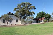
Canning Hwy Ardross
Bounded clockwise by Cunningham & Hickey Sts, McCallum Cres, Davy St, Barnard St & Canning Hwy
Melville
Metropolitan
Constructed from 1912
| Type | Status | Date | Documents |
|---|---|---|---|
| Heritage List | Adopted | 16 Jun 2020 | |
| State Register | Registered | 02 Sep 1997 | HCWebsite.Listing+ListingDocument, HCWebsite.Listing+ListingDocument |
| Type | Status | Date | Documents |
|---|---|---|---|
| (no listings) |
| Type | Status | Date | Grading/Management | |
|---|---|---|---|---|
| Category | ||||
| Art Deco Significant Bldg Survey | Completed | 30 Jun 1994 | ||
| Register of the National Estate | Indicative Place | |||
| Municipal Inventory | Adopted | 17 Jun 2014 | Category A | |
| Name | Type | Year From | Year To |
|---|---|---|---|
| Hillson Beasley. | Architect | - | - |
| Library Id | Title | Medium | Year Of Publication |
|---|---|---|---|
| 3879 | Applecross Wireless Station Wireless Hill Park Ardross Conservation Plan Part 2 | Heritage Study {Cons'n Plan} | 1999 |
| 3878 | Applecross Wireless Station Wireless Hill Park Ardross Conservation Plan | Heritage Study {Cons'n Plan} | 1999 |
| 7016 | Operator's House (fmr), Applecross Wireless Station (fmr) : schedule of maintenance works. | Heritage Study {Other} | 2003 |
Urban Park
| Epoch | General | Specific |
|---|---|---|
| Original Use | Transport\Communications | Comms: Other |
| Present Use | PARK\RESERVE | Park\Reserve |
| Style |
|---|
| Other Style |
| Type | General | Specific |
|---|---|---|
| Wall | BRICK | Common Brick |
| Wall | TILE | Other Tile |
| General | Specific |
|---|---|
| TRANSPORT & COMMUNICATIONS | Telecommunications |
This information is provided voluntarily as a public service. The information provided is made available in good faith and is derived from sources believed to be reliable and accurate. However, the information is provided solely on the basis that readers will be responsible for making their own assessment of the matters discussed herein and are advised to verify all relevant representations, statements and information.
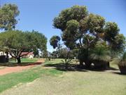
Constructed from 1912
The Wireless Hill Reserve is significant on the following grounds: Aesthetic Value: The reserve is the only remaining large area of natural bushland close to the south side of the river. Historic Value: The buildings in the reserve are all linked to the operation of the now defunct Wireless Station. Social value: The reserve enhances the quality of life for the residents of Melville and it's visitors. Rarity Value: The reserve is the only remaining large area of natural bushland close to the south side of the river. Wireless Hill Park, comprising brick and tile radio operations buildings, brick and tile staff accommodation buildings, concrete tower bases, culturally modified landscape settings and urban bushland, has cultural heritage significance for the following reasons: Radio telecommunications provided one of the important links between Australia and the rest of the world at a time when these links were significant to a relatively small community in one of the most remote cities in the world; the radio communications station has played a part in the development of commercial radio broadcasting and experimental shortwave radio as well as functioning as a communications vehicle for state government instrumentalities and marine safety; it once contained all the elements of a working radio communications station from the nascent development to eventual phasing out; the place retains sufficient 1912 fabric to remain a fine example of an early radio communications station; the place was one of five main radio telecommunication stations in Australia participating in international, national, State-wide and regional radio communications and broadcasting; the mast is remembered as a highly visible and prominent landmark both by day and with its lighting at night, until decommissioned; today, the park forms the basis of a highly valued area of urban bushland.
The reserve consists of a large tract of native bushland, the original wireless station buildings remain and a network of walking paths have been established. Wireless Hill Park comprises a 41 hectare site as a landmark site of high ground, predominantly natural Banksia and jarrah woodland, with the former Wire Station Operations buildings and structures extant on the high ground of the site, including a macadamised roadway connecting the Station to four former staff houses on the low side of the site at the northwest side. The original 112 metre tall mast and guys have been removed. The anchor blocks at the base of the mast and the three anchor blocks for the guys survive, two converted to viewing platforms. Mature introduced landscape and grassed areas, car parking, access roadway and public amenities have been introduced in the vicinity of the former Station, now converted for use as a Museum of Telecommunications and associated community facilities. Interpretive material relating to the flora and fauna of the natural bushland and of the former use of the place as a Telecommunications Station, have been introduced for public education and recreation. SIGNIFICANT ITEMS: The natural bushland; the introduced mature eucalypt tree at the west side of the Museum building; the surviving structures from the former Wireless Station: - the former Operations building – now the Caretaker's Residence - the former Engine House – now the Museum - the former Store – now toilets and Meeting Room - three concrete and masonry anchor blocks, to-date two converted to viewing platforms - three concrete anchor blocks at the base of the former mast - four former staff houses at Nos. 2, 4, 6 and 8 Hickey Street - small toilet block - the macadamised roadway from the former Operations building down to the former staff houses; Heritage Trails; and interpretive material in the locality of the bushland and the former Operations building.
The Aboriginal name for Wireless Hill is ‘Yagan’s Lookout’ and has always been a significant place for communication by the Beeliar Nyoongars . Fires were used for communication, one example was signalling the movement of fish along the Swan River. Wireless Hill was a food gathering area, as well as gathering medicinal plants by the women. Telecommunication has been defined as the transmission of data-carrying signals between two points, including telegraphy, radio, telephone, television, computer networks and satellite systems. In 1912, the Federal Government built the Wireless Hill Station, one of Australia's first telecommunication stations, using Morse Code to communicate with ships off the Australian coast using a mast 112 metres tall. Known as Perth Wireless Station, the Wireless Hill Station played an important role in both World Wars, relaying messages from ship to shore. Amalgamated Wireless Australasia took over the Station in 1922, installing at that time equipment capable of monitoring signals worldwide. In 1947, Overseas Telecommunications Commission took over the Station. The Station became part of a network controlling all of Australia's external communications. The original buildings were retained following decommissioning in 1967 and closure in 1968 when the Station was vacated and the land vested in the City of Melville as a public reserve and museum of telecommunications. The original generator room was adapted as a museum, the three anchor blocks to steady the 112 metre high aerial are currently in process of conversion as viewing platforms – one block remains to be completed. Staff houses on the site were restored for ongoing residential and special community use. The site has been converted to a public park, retaining the substantial original 41 hectares of Banksia and jarrah natural bushland on the site, with grassed and landscaped areas including carparks and access roads on top of the hill around the original Station buildings. The Museum Collection is a nationally significant collection of telecommunications equipment. Community facilities have been incorporated into the parkland adjacent to and within the original buildings. The paved roadway connecting the Station down the hill to the staff houses survives, in a deteriorated condition of original fabric that is currently the focus of restoration. Professionally prepared interpretation material is located sensitively around the site to explain the significance of the natural bushland, its flora and fauna, and the original functions of the Wireless Hill Station.
Extent of Original Fabric: The reserve remains in it's original bushland form, a management strategy has been prepared to protect and maintain the reserve.
Good
| Name | Type | Year From | Year To |
|---|---|---|---|
| Hillson Beasley (PWD) | Architect | 1912 | - |
| Ref ID No | Ref Name | Ref Source | Ref Date |
|---|---|---|---|
| interpretive material on site, and pamphlets | City of Melville | ||
| Kelly Aris, Helen Burgess and Gaye Nayton;Conservation Plan Applecross Wireless Station (fmr), Wireless Hill Park, Ardross' | City of Melville | 1999 | |
| HGM Report 'Conservation and Upgrading' | May 2001 | ||
| State Register of Heritage Places Assessment documentation for Place No. 03518 'Wireless Hill Park' | Heritage Council of Western Australia | 2 September 19997. |
| Owner | Category |
|---|---|
| City of Melville | Local Gov't |
This information is provided voluntarily as a public service. The information provided is made available in good faith and is derived from sources believed to be reliable and accurate. However, the information is provided solely on the basis that readers will be responsible for making their own assessment of the matters discussed herein and are advised to verify all relevant representations, statements and information.
Canning Hwy Ardross
Bounded clockwise by Cunningham & Hickey Sts, McCallum Cres, Davy St, Barnard St & Canning Hwy REGISTERED AS PART OF 3518
Telecommunication Station (fmr)
Melville
Metropolitan
Constructed from 1912
| Type | Status | Date | Documents |
|---|---|---|---|
| (no listings) |
| Type | Status | Date | Documents |
|---|---|---|---|
| (no listings) |
| Type | Status | Date | Grading/Management | |
|---|---|---|---|---|
| Category | ||||
| Classified by the National Trust | Classified | 03 Aug 1992 | ||
| Classified by the National Trust | Classified {Lscpe} | |||
03518 Wireless Hill Park
Very good.
Individual Building or Group
| Epoch | General | Specific |
|---|---|---|
| Original Use | Transport\Communications | Comms: Other |
| Present Use | EDUCATIONAL | Museum |
| Type | General | Specific |
|---|---|---|
| Roof | TILE | Other Tile |
| Wall | BRICK | Painted Brick |
| General | Specific |
|---|---|
| SOCIAL & CIVIC ACTIVITIES | Sport, recreation & entertainment |
| TRANSPORT & COMMUNICATIONS | Telecommunications |
This information is provided voluntarily as a public service. The information provided is made available in good faith and is derived from sources believed to be reliable and accurate. However, the information is provided solely on the basis that readers will be responsible for making their own assessment of the matters discussed herein and are advised to verify all relevant representations, statements and information.
The Wireless Station which was built on the site, the buildings of which remain largely intact today, date practically from the inception of radio communications anywhere in the world. One of the earliest wireless stations in Australia. The technology in 1912 would have been little different from that used by Marconi in 1901. The Station was used continuously from 1912 to 1967 as the main coasta l radio communications centre for the state and additionally from the 1920's as a feeder station for radiograms within Australia, and from 1943 as a secondary station for international messages. It encompasses an era in technology . The phasing out of Applecross coincided with the introduction of world wide communications using satellites. This is not to say that traditional wireless communications have been phased out. Perth's l.T.,C.'s maritime operations centre at Gnangara (call sign VIP) continues to provide a range of vital H.F. and V.H.F. services 24 hours per day. The station was important because of its dominant location and general acceptance as a land mark in the metropolitan area. SCARCITY This would be a practically unique situation in Australia where almost the whole original premises of one of the first wireless stations in Australia exists in practically its pristine state.
Perth Wireless Station was one of the first coastal wireless stations to commence construction and was the fifth to become operational. Along with Pennant Hills it was the most powerful station in Australia. The Applecross station was completed on the 30th September, 1912. The equipment in the station varied over the yea rs to meet the changing demands on the station as well as changes in the technology. The prime purpose of the station was for contact with ships at sea, thus providing some sense of security for the ships, as well as the taking and sending of commercial traffic from shipping. Applecross and Pen nant Hills were also able to contact each other, thus provid ing an emergency link across the continent in the event of other communication links failing. The station commenced operations under the control of the Post Master General 's Department. In 1915 all stations in Australia were taken over by the navy in the interest of national security, passing back to the P.M.G. in 1920. As part of a deal to establish a direct wireless link with Britain, the Commonwealth Government in 1922 handed over the control of all coastal wireless stations in Australia to Amalgamated Wireless Australasia, at the same time taking a 50% equity in the company. A.W.A. were to establish a main link with Britain from a station in the Eastern States and the coastal stations were to act as feeder stations to the main station. A.W.A. remained in control of the stations, including Applecross until the formation of O.T.C. and the handing over of the station in 1947. During the Second World War, Applecross remained under the management and ownership of A.W.A., although perhaps under the ultimate control of the navy. During the war Applecross assumed the role of an intermediate relay station for the Beam System when atmospheric conditions limited the hours when direct contact could be made. A second station was established at Bassendean in 1943 and the operators were shifted there, returning to Applecross in 1946. Applecross remained in use during this period as a transmitting site only. The Perth relay facilities were re-established in 1952 to establish an alternative route to britain during the approaching trough in the sun spot cycle. The operators and receivers were removed from Applecross in 1953 and until its final closure in 1967 Applecross remained as a transmitting station only. Following the closure of the station in 1967 the site was purchased by the City of Melville for use as a public reserve. A prominent feature of the station was the 394 foot high mast erected at the crest of the hill and which dominated the surroundings. Due to the coast of maintenance it was replaced in 1962 BY A 46 metre high mast which was removed in 1967 with the closure of the station. The equipment originally installed in 1912 was a Telefunken crystal receiver and a spark transmitter powered by a diesel driven 500 cycle alternator. While the navy were in control during the First World War they installed a valve receiver and a Poulsen arc transmitter. When A.W.A. assumed control in 1922 a valve transmitter was installed which was subsequently updated in 1927. These transmitters still relied on rotating machinery in the engine house for their source of power. At some stage the rotating machinery was dispensed with and the transmitters operated direct from the mains supply. In 1942 Mr. F. James commenced work with A.W.A. and his first task was connected with the removal of the machinery from the engine house. Little is known about the receivers. A picture of the operators room in 1931shows a receiver with plug in coils on the front panel. By 1934, a switch had apparently been installed to facilitate band changing.
Assessment 1992 Construction 1912
This information is provided voluntarily as a public service. The information provided is made available in good faith and is derived from sources believed to be reliable and accurate. However, the information is provided solely on the basis that readers will be responsible for making their own assessment of the matters discussed herein and are advised to verify all relevant representations, statements and information.
Canning Hwy Ardross
REGISTERED AS PART OF 3518
Lookout Tower
Melville
Metropolitan
Constructed from 1912
| Type | Status | Date | Documents |
|---|---|---|---|
| (no listings) |
| Type | Status | Date | Documents |
|---|---|---|---|
| (no listings) |
| Type | Status | Date | Grading/Management | |
|---|---|---|---|---|
| Category | ||||
| (no listings) | ||||
03518 Wireless Hill Park
| Library Id | Title | Medium | Year Of Publication |
|---|---|---|---|
| 7835 | A history of Wireless Hill, Melville, 1912-1967. | Heritage Study {Other} | 1993 |
Historic site
| Epoch | General | Specific |
|---|---|---|
| Original Use | Transport\Communications | Comms: Other |
| Present Use | Transport\Communications | Comms: Other |
This information is provided voluntarily as a public service. The information provided is made available in good faith and is derived from sources believed to be reliable and accurate. However, the information is provided solely on the basis that readers will be responsible for making their own assessment of the matters discussed herein and are advised to verify all relevant representations, statements and information.
2 Hickey St Ardross
REGISTERED AS PART OF 3518
Melville
Metropolitan
Constructed from 1912
| Type | Status | Date | Documents |
|---|---|---|---|
| (no listings) |
| Type | Status | Date | Documents |
|---|---|---|---|
| (no listings) |
| Type | Status | Date | Grading/Management | |
|---|---|---|---|---|
| Category | ||||
| (no listings) | ||||
03518 Wireless Hill Park
Very Good.
| Library Id | Title | Medium | Year Of Publication |
|---|---|---|---|
| 7835 | A history of Wireless Hill, Melville, 1912-1967. | Heritage Study {Other} | 1993 |
Individual Building or Group
| Epoch | General | Specific |
|---|---|---|
| Present Use | RESIDENTIAL | Single storey residence |
| Original Use | Transport\Communications | Comms: Housing or Quarters |
| Type | General | Specific |
|---|---|---|
| Wall | BRICK | Common Brick |
| Roof | TILE | Other Tile |
| General | Specific |
|---|---|
| TRANSPORT & COMMUNICATIONS | Telecommunications |
This information is provided voluntarily as a public service. The information provided is made available in good faith and is derived from sources believed to be reliable and accurate. However, the information is provided solely on the basis that readers will be responsible for making their own assessment of the matters discussed herein and are advised to verify all relevant representations, statements and information.
4 Hickey St Ardross
REGISTERED AS PART OF 3518
Melville
Metropolitan
Constructed from 1912
| Type | Status | Date | Documents |
|---|---|---|---|
| (no listings) |
| Type | Status | Date | Documents |
|---|---|---|---|
| (no listings) |
| Type | Status | Date | Grading/Management | |
|---|---|---|---|---|
| Category | ||||
| (no listings) | ||||
03518 Wireless Hill Park
Good.
| Library Id | Title | Medium | Year Of Publication |
|---|---|---|---|
| 7835 | A history of Wireless Hill, Melville, 1912-1967. | Heritage Study {Other} | 1993 |
Individual Building or Group
| Epoch | General | Specific |
|---|---|---|
| Present Use | RESIDENTIAL | Single storey residence |
| Original Use | Transport\Communications | Comms: Housing or Quarters |
| Type | General | Specific |
|---|---|---|
| Wall | BRICK | Common Brick |
| Roof | TILE | Other Tile |
| General | Specific |
|---|---|
| TRANSPORT & COMMUNICATIONS | Telecommunications |
This information is provided voluntarily as a public service. The information provided is made available in good faith and is derived from sources believed to be reliable and accurate. However, the information is provided solely on the basis that readers will be responsible for making their own assessment of the matters discussed herein and are advised to verify all relevant representations, statements and information.
6 Hickey St Ardross
REGISTERED AS PART OF 3518
Melville
Metropolitan
Constructed from 1912
| Type | Status | Date | Documents |
|---|---|---|---|
| (no listings) |
| Type | Status | Date | Documents |
|---|---|---|---|
| (no listings) |
| Type | Status | Date | Grading/Management | |
|---|---|---|---|---|
| Category | ||||
| (no listings) | ||||
03518 Wireless Hill Park
Good.
| Library Id | Title | Medium | Year Of Publication |
|---|---|---|---|
| 7835 | A history of Wireless Hill, Melville, 1912-1967. | Heritage Study {Other} | 1993 |
Individual Building or Group
| Epoch | General | Specific |
|---|---|---|
| Original Use | Transport\Communications | Comms: Housing or Quarters |
| Present Use | SOCIAL\RECREATIONAL | Other Community Hall\Centre |
| Type | General | Specific |
|---|---|---|
| Wall | BRICK | Common Brick |
| Roof | TILE | Other Tile |
| General | Specific |
|---|---|
| TRANSPORT & COMMUNICATIONS | Telecommunications |
This information is provided voluntarily as a public service. The information provided is made available in good faith and is derived from sources believed to be reliable and accurate. However, the information is provided solely on the basis that readers will be responsible for making their own assessment of the matters discussed herein and are advised to verify all relevant representations, statements and information.
8 Hickey St Ardross
REGISTERED AS PART OF 3518
Melville
Metropolitan
Constructed from 1912
| Type | Status | Date | Documents |
|---|---|---|---|
| (no listings) |
| Type | Status | Date | Documents |
|---|---|---|---|
| (no listings) |
| Type | Status | Date | Grading/Management | |
|---|---|---|---|---|
| Category | ||||
| (no listings) | ||||
03518 Wireless Hill Park
Very good.
| Library Id | Title | Medium | Year Of Publication |
|---|---|---|---|
| 7835 | A history of Wireless Hill, Melville, 1912-1967. | Heritage Study {Other} | 1993 |
Individual Building or Group
| Epoch | General | Specific |
|---|---|---|
| Present Use | RESIDENTIAL | Single storey residence |
| Original Use | Transport\Communications | Comms: Housing or Quarters |
| Type | General | Specific |
|---|---|---|
| Roof | TILE | Other Tile |
| Wall | BRICK | Common Brick |
| General | Specific |
|---|---|
| TRANSPORT & COMMUNICATIONS | Telecommunications |
This information is provided voluntarily as a public service. The information provided is made available in good faith and is derived from sources believed to be reliable and accurate. However, the information is provided solely on the basis that readers will be responsible for making their own assessment of the matters discussed herein and are advised to verify all relevant representations, statements and information.
Wireless Hill Ardross
Melville
Metropolitan
Constructed from 1969
| Type | Status | Date | Documents |
|---|---|---|---|
| (no listings) |
| Type | Status | Date | Documents |
|---|---|---|---|
| (no listings) |
| Type | Status | Date | Grading/Management | |
|---|---|---|---|---|
| Category | ||||
| (no listings) | ||||
03518 Wireless Hill Park
Good.
Landscape
| Epoch | General | Specific |
|---|---|---|
| Original Use | SOCIAL\RECREATIONAL | Other |
| Present Use | SOCIAL\RECREATIONAL | Other |
| General | Specific |
|---|---|
| SOCIAL & CIVIC ACTIVITIES | Sport, recreation & entertainment |
| SOCIAL & CIVIC ACTIVITIES | Education & science |
This information is provided voluntarily as a public service. The information provided is made available in good faith and is derived from sources believed to be reliable and accurate. However, the information is provided solely on the basis that readers will be responsible for making their own assessment of the matters discussed herein and are advised to verify all relevant representations, statements and information.
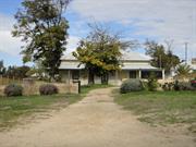
9 Spinaway Cr Brentwood
Cnr Pulo Rd & Spinaway Cr
Bateman Homestead
Melville
Metropolitan
Constructed from 1886
| Type | Status | Date | Documents |
|---|---|---|---|
| Heritage List | Adopted | 16 Jun 2020 | |
| Heritage Agreement | YES | 04 Feb 2005 | HCWebsite.Listing+ListingDocument |
| State Register | Registered | 14 May 2002 | HCWebsite.Listing+ListingDocument, HCWebsite.Listing+ListingDocument |
| Type | Status | Date | Documents |
|---|---|---|---|
| (no listings) |
| Type | Status | Date | Grading/Management | |
|---|---|---|---|---|
| Category | ||||
| Municipal Inventory | Adopted | 17 Jun 2014 | Category A | |
| Classified by the National Trust | Classified | 05 Feb 1979 | ||
| Register of the National Estate | Permanent | 28 Sep 1982 | ||
| Library Id | Title | Medium | Year Of Publication |
|---|---|---|---|
| 4476 | Fremantle Studies: journal of the Fremantle History Society. | Serial | 1999 |
| 7190 | Grasmere Homestead, Grasmere Landing : conservation plan. | Heritage Study {Cons'n Plan} | 2004 |
Individual Building or Group
| Epoch | General | Specific |
|---|---|---|
| Present Use | RESIDENTIAL | Single storey residence |
| Original Use | FARMING\PASTORAL | Homestead |
| Style |
|---|
| Victorian Georgian |
| Type | General | Specific |
|---|---|---|
| Roof | METAL | Corrugated Iron |
| Wall | METAL | Corrugated Iron |
| Wall | BRICK | Rendered Brick |
| General | Specific |
|---|---|
| PEOPLE | Early settlers |
| SOCIAL & CIVIC ACTIVITIES | Sport, recreation & entertainment |
This information is provided voluntarily as a public service. The information provided is made available in good faith and is derived from sources believed to be reliable and accurate. However, the information is provided solely on the basis that readers will be responsible for making their own assessment of the matters discussed herein and are advised to verify all relevant representations, statements and information.
Constructed from 1886
The Bateman Homestead is significant for the following reason: Aesthetic Value: Typical homestead of the period set in rural surroundings. Historic Value: Originally built as a holiday home for prominent pioneer John Bateman. Later to become a farmhouse. Authenticity: The building is substantially in it's original form. Grasmere Homestead, a single-storey, rendered brick and corrugated iron homestead (1886) in the Victorian Georgian style, together with various framed construction and iron clad outbuildings, set in what remains of a rural landscape, has cultural heritage significance for the following reasons: the place is a rare and fine example of a single-storey homestead in the Victorian Georgian style dating from the 1880s in metropolitan Perth; in spite of changes to the fabric, the place manages to retain its original design qualities and the plan form and the proportions of all the rooms of the original house are as constructed and provide pleasant living spaces; located on a rise above Bull Creek, the place has landmark quality as a gentle, simple and aesthetically pleasing vista; the remnants of the late nineteenth century and early twentieth century plantings, in particular the palm and pine trees, contribute to the overall setting; the place has historic associations with the Canning River, which was the major transport route for goods and people travelling to and from Grasmere before a road was built to the property; a private jetty was located at the bottom of the gardens, which extended from the house to the river; the place is of social value in the context of the development of Western Australia as one of the earliest extant homesteads representing the early development of areas to the south of the Swan River; built as a holiday and weekend retreat in the 1880s, the place became the homestead for the property as it was developed and worked by the prominent Fremantle-based Bateman family, through the late nineteenth century and for more than 70 years of the twentieth century. The current perimeter fences are considered to have low significance. The metal framed and metal clad sheds are considered to be intrusive. Any surviving plantings of eucalypts and other trees are considered to have low significance. SIGNIFICANT ITEMS: The form of the original fabric of the building and any surviving original details and materials, externally and internally. Alterations and enclosures have little if any significance.
A single storey, rendered brick and corrugated iron six room hoemstead built in the Victorian Georgian style. It has a central passage with verandahs all around set in rural surroundings adjacent to Bull Creek. Evidence of the original orchard and gardens remain.
The Location 28 of 1,280 acres was granted initially to Thomas Middleton in May 1830. Middleton moved his family to Perth in 1831. In the 1830s the settlers in the locality were issued with freehold titles. Disputes with Aborigines and destruction of Middleton's house by fire saw an attempt in 1835 to sell the property or to lease the land. Both were unsuccessful. Little further development at Location 28 was evident until in 1851 Alexander Francisco acquired the property. Francisco's heirs mortgaged the property to John Bateman in 1881. In 1885, John Wesley Bateman, Merchant and Shipowner of Fremantle, and John's eldest son, purchased the property. In 1886 Grasmere Homestead was constructed as a weekend retreat for the Bateman family on a site overlooking Bull's Creek. Access to the house was primarily by boat. Various members of the Bateman lived in or used the homestead and surrounding farmlands. Finally in 1951-1954 the property was reduced to 872 acres by selling off the land to the State Housing Commission for post World War II housing development. Further reductions in the site occurred in 1956 and 1958 and finally in 1964 and 1978. Bateman family members continued on the property until the early 1970s when tenants were introduced, including up to the early 2000s when ownership had passed to the present owners for the current lot of 1,402 sq. metres.
Modifications: Some Extent of Original Fabric: Much
Deteriorated.
| Ref ID No | Ref Name | Ref Source | Ref Date |
|---|---|---|---|
| ‘Grasmere Homestead Grasmere Landing’ Conservation Plan | Hocking Planning & Architects for Spinnaway Investments Pty. Ltd. | July 2004 |
| Owner | Category |
|---|---|
| Spinnaway Investments Pty Ltd | Other Private |
This information is provided voluntarily as a public service. The information provided is made available in good faith and is derived from sources believed to be reliable and accurate. However, the information is provided solely on the basis that readers will be responsible for making their own assessment of the matters discussed herein and are advised to verify all relevant representations, statements and information.
It is a typical homestead of the period, historically important as one of the few remaining substantial dwellings in this area of Melville and for its association with the Bateman's, pioneers in this district as well as in Fremantle. It is held in high esteem by the City of Melville.
Assessment 1997 Construction: 1886 Built by John Bateman who acquired the 514 hectare grant in 1886 and originally used as a holiday house. Grasmere became a permanent home for the next generation of Bateman family who farmed the property. The house and 2.13 hectares of land remaining after subdivision is still in Bateman ownership and occupation. Attractively situated on a rise overlooking the head of Bull Creek, with tall pines between it and Pulo Road, The well-preserved brick house is surrounded by verandahs, with its original corrugated iron roof.
t
This information is provided voluntarily as a public service. The information provided is made available in good faith and is derived from sources believed to be reliable and accurate. However, the information is provided solely on the basis that readers will be responsible for making their own assessment of the matters discussed herein and are advised to verify all relevant representations, statements and information.
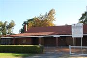
3 Baal St Palmyra
Cnr Elvira & Baal Sts
Millers' Bakehouse
Melville
Metropolitan
Constructed from 1935
| Type | Status | Date | Documents |
|---|---|---|---|
| Heritage List | Adopted | 16 Jun 2020 | |
| State Register | Registered | 27 Aug 1999 | HCWebsite.Listing+ListingDocument, HCWebsite.Listing+ListingDocument |
| Type | Status | Date | Documents |
|---|---|---|---|
| (no listings) |
| Type | Status | Date | Grading/Management | |
|---|---|---|---|---|
| Category | ||||
| Classified by the National Trust | Classified | 11 May 1987 | ||
| Municipal Inventory | Adopted | 17 Jun 2014 | Category A | |
| Library Id | Title | Medium | Year Of Publication |
|---|---|---|---|
| 3809 | Millers' Bakehouse Museum Conservation Plan | Heritage Study {Cons'n Plan} | 1995 |
| 2400 | Industrial heritage schools competition 1990. | Report | 1990 |
Individual Building or Group
| Epoch | General | Specific |
|---|---|---|
| Original Use | INDUSTRIAL\MANUFACTURING | Bakery |
| Present Use | EDUCATIONAL | Museum |
| Style |
|---|
| Vernacular |
| Type | General | Specific |
|---|---|---|
| Roof | TILE | Terracotta Tile |
| Wall | BRICK | Common Brick |
| General | Specific |
|---|---|
| OCCUPATIONS | Commercial & service industries |
| SOCIAL & CIVIC ACTIVITIES | Cultural activities |
This information is provided voluntarily as a public service. The information provided is made available in good faith and is derived from sources believed to be reliable and accurate. However, the information is provided solely on the basis that readers will be responsible for making their own assessment of the matters discussed herein and are advised to verify all relevant representations, statements and information.
Constructed from 1935
The Museum/Bakehouse is significant for the following reasons: Historic Value: The building remains in its original condition as a small commercial bakery which served the local area. Scientific value: Contains the original oven, in situ and intact. Social Value: Demonstrates an important facet of daily life in the early days of the district. Rarity: One of the few remaining examples of an intact bakery from this period. Miller Bakehouse is the commercial adjunct to the Miller House. Miller Bakehouse, a single-storey brick and tile bakehouse building, has cultural heritage significance for the following reasons: the place is a rare example of a working residential bakehouse which retains substantial equipment and machinery dating from the period of use as a working bakery; the place is a rare example of a working residential bakehouse constructed in the 1930s in metropolitan Perth; the place is an example of a family business which supplied bread to the Fremantle and Palmyra area from the 1930s until its closure in 1976; the place is significant for the design and construction of the bread oven based on design principles developed in the mid to late nineteenth century and is one of the few remaining ovens of this type. SIGNIFICANT ITEMS: The external form, material and details of the original fabric, and the location set back from street boundaries in the current site landscaped as a park; the original oven and bakery equipment.
Detached building set in a small reserve adjacent to the original owners home, the building contains much of its original baking equipment. A single-storey red brick commercial building with gabled ends half-timbered, roof clad in orange Marseilles pattern terracotta tiles. A recessed open verandah extends along the eastern side facing onto the former service yard.
Miller Bakehouse, the commercial adjunct to the Miller House, was constructed for Henry Miller, baker, and his family in 1935 on land adjacent to the 1929 Miller House in a residential subdivision. The Miller family bakery business serviced the district from 1929 until 1976, using a horse-drawn bread cart for deliveries. The bakehouse, surviving oven and bakery equipment represent suburban living and the custom of one of the local service industries located throughout residential districts in the decades prior to supermarkets and shopping centres and the demise of the 'corner store'. The two buildings are now set in landscaped parkland.
Modifications: Some Extent of Original Fabric: Most. It has been returned to it's original state as a bakery.
Good- Sound
| Ref ID No | Ref Name | Ref Source | Ref Date |
|---|---|---|---|
| P1548 | State Register of Heritage Places Assessment documentation for Place No. 01548 'Millers' Bakehouse Museum' | Heritage Council of Western Australia | 27/8/1999 |
| Owner | Category |
|---|---|
| City of Melville | Local Gov't |
This information is provided voluntarily as a public service. The information provided is made available in good faith and is derived from sources believed to be reliable and accurate. However, the information is provided solely on the basis that readers will be responsible for making their own assessment of the matters discussed herein and are advised to verify all relevant representations, statements and information.