Local Government
York
Region
Avon Arc
44 Ford St York
Lot 104
York
Avon Arc
Constructed from 1900, Constructed from 1920
| Type | Status | Date | Documents |
|---|---|---|---|
| Heritage List | Adopted | 25 Nov 2019 |
| Type | Status | Date | Documents |
|---|---|---|---|
| (no listings) |
| Type | Status | Date | Grading/Management | |
|---|---|---|---|---|
| Category | ||||
| Local Heritage Survey | Adopted | 25 Nov 2019 | Grade B | |
Good as @ 2007
Individual Building or Group
| Epoch | General | Specific |
|---|---|---|
| Present Use | RESIDENTIAL | Single storey residence |
This information is provided voluntarily as a public service. The information provided is made available in good faith and is derived from sources believed to be reliable and accurate. However, the information is provided solely on the basis that readers will be responsible for making their own assessment of the matters discussed herein and are advised to verify all relevant representations, statements and information.

Constructed from 1912
Residence, 44 Ford Street is significant as fine intact example of a Federation bungalow that demonstrates a prosperous period of development and contributes to the historic townscape of York. Close associations with Mrs Pamela Inkpen, a community identity held in high esteem, contributes to the historical significance of the place.
The single storey residence has a distinctive high-pitched hipped gambrel roof that extends over the perimeter veranda. The face brick walls have a rendered band at window sill level. A tall face brick chimney with rendered corbel dominates the roof line. The veranda has a decorative spaced vertical timber valance. The expansive frontage appears symmetrical, although the elements flanking the central front door are different with a rectangular bay window on one side and a pair of s spaced double-hung sash windows on the other side of the front wall.
The rate books indicate that the property was vacant in 1910 and 1911. In 1966, the rate books show the occupier as Ray Geoffrey Inkpen, husband of Pam Inkpen. Mrs Pamela Inkpen (1923-2003) resided here. She was granted the privilege of Freeman of York on 31 May 2002, after already becoming a life member of The York Society in the 1990s. She was an active community member in York.
High
Good
This information is provided voluntarily as a public service. The information provided is made available in good faith and is derived from sources believed to be reliable and accurate. However, the information is provided solely on the basis that readers will be responsible for making their own assessment of the matters discussed herein and are advised to verify all relevant representations, statements and information.
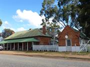
Ford St & Avon Tce York
York
Avon Arc
Constructed from 1979
| Type | Status | Date | Documents |
|---|---|---|---|
| (no listings) |
| Type | Status | Date | Documents |
|---|---|---|---|
| RHP - Does not warrant assessment | Current | 02 Sep 2012 |
| Type | Status | Date | Grading/Management | |
|---|---|---|---|---|
| Category | ||||
| (no listings) | ||||
Good
Individual Building or Group
| Epoch | General | Specific |
|---|---|---|
| Other Use | GOVERNMENTAL | Police Station or Quarters |
| General | Specific |
|---|---|
| SOCIAL & CIVIC ACTIVITIES | Law & order |
This information is provided voluntarily as a public service. The information provided is made available in good faith and is derived from sources believed to be reliable and accurate. However, the information is provided solely on the basis that readers will be responsible for making their own assessment of the matters discussed herein and are advised to verify all relevant representations, statements and information.
Forrest St York
Heartleap
York
Avon Arc
Constructed from 1905 to 1916
| Type | Status | Date | Documents |
|---|---|---|---|
| (no listings) |
| Type | Status | Date | Documents |
|---|---|---|---|
| RHP - To be assessed | Current | 25 Jul 2003 |
| Type | Status | Date | Grading/Management | |
|---|---|---|---|---|
| Category | ||||
| Register of the National Estate | Indicative Place | |||
| Classified by the National Trust | Classified | 01 Apr 1985 | ||
| Register of the National Estate | Nominated | 25 Sep 1985 | ||
| Municipal Inventory | Adopted | 29 Sep 2008 | Grade C | |
The place is a fine example of a substantial brick residence in the Federation Queen Anne style.
The place has landmark value, being one of the first buildings sited on the main road into York, and for its location on the hill overlooking the town.
The place has associations with the development of York, in particular in the late nineteenth century due to the construction of the railway and the goldrushes.
The place has associations with well known businessman and local politician Charles Edwards, who was responsible for the construction of the place in 1916.
The place is a single storey brick building located in a picturesque rural setting on a slight hill overlooking the town of York. The place has a terracotta tiled roof which features prominent gables as well as several tall brick chimney with rendered corbels. The building also has at least one bay. The building has a surrounding verandah with decorative timber valances and balustrades.
The Edwards family general merchandise and produce business was founded in 1868 by William Edwards. After his retirement the business was inherited by his two sons, Charles and Kenneth. The brothers were together for 15 years before the partnership was dissolved in 1892, with Charles carrying on management. A commercial building was built for him in the 1880s/1890s (this is now known as the York Co-op). Charles is reported to have owned the property on which the place is located by the 1880s. He had constructed ‘Hartsleap’, the family home there and was in residence by 1905. In 1916, Edwards constructed another substantial residence on the property, adjacent to Hartsleap. This was known as ‘Hillside’. Local history has it that the place was designed by well known architect George Temple Poole. Charles Edwards was involved for many years as a councillor of the York local government; becoming first involved in 1877. He served as mayor in 1889 and 1898 – 1900, after several years in the eastern states. He was also in partnership with Mr Quigley in a mill in York. In 2003, the place continues to be used for residential purposes.
Integrity- High Authenticity- Moderate
Good
| Name | Type | Year From | Year To |
|---|---|---|---|
| George Temple Poole | Architect | - | - |
Individual Building or Group
| Epoch | General | Specific |
|---|---|---|
| Original Use | RESIDENTIAL | Single storey residence |
| Present Use | COMMERCIAL | Hotel, Tavern or Inn |
| Present Use | RESIDENTIAL | Single storey residence |
| Style |
|---|
| Federation Queen Anne |
| Type | General | Specific |
|---|---|---|
| Roof | TILE | Terracotta Tile |
| Wall | BRICK | Common Brick |
| General | Specific |
|---|---|
| OCCUPATIONS | Commercial & service industries |
| OCCUPATIONS | Grazing, pastoralism & dairying |
| DEMOGRAPHIC SETTLEMENT & MOBILITY | Settlements |
This information is provided voluntarily as a public service. The information provided is made available in good faith and is derived from sources believed to be reliable and accurate. However, the information is provided solely on the basis that readers will be responsible for making their own assessment of the matters discussed herein and are advised to verify all relevant representations, statements and information.
Historic significance: An imposing large house built in 1916 by Charles Edwards who earlier, in the 1880s had also constructed the adjacent Hartleap House. The two houses, from differing stylistic periods, demonstrate great similarity and only subtle changes in detail. They show the continuing prosperity of a successful farming and business family. The apartness of these two houses sited together on high open land overlooking the town but not part of the town is indicative of Edwards their builder who fulfilled for York what Bland and Monger had founded – a thriving and unified commercial centre.
A large red brick house with terracotta tiled roof, decorated gables and encircling timber verandahs.
Integrity: Good Authenticity: Good
Good
This information is provided voluntarily as a public service. The information provided is made available in good faith and is derived from sources believed to be reliable and accurate. However, the information is provided solely on the basis that readers will be responsible for making their own assessment of the matters discussed herein and are advised to verify all relevant representations, statements and information.
15 Forrest St York
York
Avon Arc
Constructed from 1916
| Type | Status | Date | Documents |
|---|---|---|---|
| Heritage List | Adopted | 25 Nov 2019 |
| Type | Status | Date | Documents |
|---|---|---|---|
| (no listings) |
| Type | Status | Date | Grading/Management | |
|---|---|---|---|---|
| Category | ||||
| Local Heritage Survey | Adopted | 25 Nov 2019 | Grade B | |
02873 Hillside Farmhouse & Hartleap Farmhouse Group
Individual Building or Group
| Epoch | General | Specific |
|---|---|---|
| Original Use | RESIDENTIAL | Single storey residence |
| Present Use | RESIDENTIAL | Single storey residence |
| Type | General | Specific |
|---|---|---|
| Roof | TILE | Other Tile |
| Wall | BRICK | Common Brick |
This information is provided voluntarily as a public service. The information provided is made available in good faith and is derived from sources believed to be reliable and accurate. However, the information is provided solely on the basis that readers will be responsible for making their own assessment of the matters discussed herein and are advised to verify all relevant representations, statements and information.

Constructed from 1916
Hillside is an expansive example of a Federation Queen Anne style residence the work of esteemed Architect Sir John Talbot Hobbs, that demonstrates its development over time. The associations with the Edwards family are significant, linking Hillside with Hartleap with stylistic details, physical locality, and the Edwards family, historically demonstrating their prosperity and farming and commercial enterprises. Individually, and together with Hartleap, Hillside is significant in contributing to the history and historic townscape of York. changes in detail. They show the continuing prosperity of a successful farming and business family. The apartness of these two houses sited together on high open land overlooking the town but not part of the town is indicative of Edwards their builder who fulfilled for York what Bland and Monger had founded – a thriving and unified commercial centre.
Located in an elevated position with commanding views of the town, the expansive residence indicates considerable additions, similar in style to the original build. The face brick building mostly has verandas; the 1916 residence evidencing arched valances with spaced vertical timbers, and balustrades with the same style timbers. The 1916-hipped roof is complex, with vented gablets, facetted bays and separate verandas roofs. The chimneys have rendered corbels and clay pots on top. Views from the street are obscured. The drive to Hartleap and Hillside (same entry) shows Hartleap at the end, Hillside is a left turn at the end of the entry drive.
Charles Edwards (1850-1927) the second son, married Charlotte Elizabeth (Bessie) Brown in 1881. In c.1871-72, William Edwards Jr constructed the original part of what is now the York Co-op. Hewitt Morris Edwards (1884-1958), the only son of Charles and Charlotte Edwards was educated in Adelaide and joined the staff of Foy & Gibson to gain commercial training. On his return to York, he took over management of the Stores at York and Greenhills from his father in 1905, and later managed Hartleap Hill. Ownership of all three stores (York, Greenhills and Beverley) transferred to Hewitt Edwards. Hewitt Morris Edwards married Emily Morris in 1911. Charles Edwards engaged Sir John Talbot Hobbs to design Hillside for the newlyweds. Hewitt was chairman and director of many companies, including Lynas Motors, General Investments York, Perth Flour Mills and Nicholsons Ltd. He formed the York Jockey Club in 1913 and was its chairman for thirty-one years, as well as a committee member of the WA Turf Club for thirty-four years and a life member. He sold out of Edwards Stores in 1936. Hillside Country Retreat. Sir John Talbot Hobbs; born and educated in London, arrived in WA in 1887 and commence his architectural practice until partnership with WJ Waldie Forbes and EH Dean Smith in 1904: Hobbs Forbes Smith. Examples of his prolific practice include Albany House (1885), Scots Church Fremantle (1887), Weld Club (1892), Westralian Banks throughout the state, Westralian newspaper House (1895), Moirs Chambers (1896), St Johns Hall Fremantle (1897) Swan Brewery (1897) and Minawarra for Walter James, and his own home ‘Bungalow’ (1899). In partnership from 1904, examples include: Swan Brewery bottling works (1905), Boans Department Store 1905). After his decorated service during World War One, he continued proactive in the partnership with outstanding architecture of Guildford Grammar (1930), Newspaper House (1930-32) Kings Park War Memorial (1930), PO building (1930), Criterion Hotel (1937).
Integrity: High Authenticity: Moderate/high
Good
This information is provided voluntarily as a public service. The information provided is made available in good faith and is derived from sources believed to be reliable and accurate. However, the information is provided solely on the basis that readers will be responsible for making their own assessment of the matters discussed herein and are advised to verify all relevant representations, statements and information.
29 Fraser St York
York
Avon Arc
Constructed from 1910
| Type | Status | Date | Documents |
|---|---|---|---|
| Heritage List | Adopted | 25 Nov 2019 |
| Type | Status | Date | Documents |
|---|---|---|---|
| (no listings) |
| Type | Status | Date | Grading/Management | |
|---|---|---|---|---|
| Category | ||||
| Local Heritage Survey | Adopted | 25 Nov 2019 | Grade B | |
Individual Building or Group
| Epoch | General | Specific |
|---|---|---|
| Original Use | RESIDENTIAL | Single storey residence |
| Present Use | RESIDENTIAL | Single storey residence |
| Type | General | Specific |
|---|---|---|
| Roof | METAL | Corrugated Iron |
| Wall | BRICK | Common Brick |
| General | Specific |
|---|---|
| DEMOGRAPHIC SETTLEMENT & MOBILITY | Land allocation & subdivision |
This information is provided voluntarily as a public service. The information provided is made available in good faith and is derived from sources believed to be reliable and accurate. However, the information is provided solely on the basis that readers will be responsible for making their own assessment of the matters discussed herein and are advised to verify all relevant representations, statements and information.

Constructed from 1913
The Mount, the residence at 29 Fraser Street is significant as fine intact example of a Federation Queen Anne architectural style residence located in an extensive prominent site. It is one of few such expansive examples of the period and style in York, built for the long-term owners of the property, Frances and Gerald Wrench. It demonstrates a prosperous period of development and makes a significant contribution to the historic fabric of York town.
The Mount is set a long way back from the its front facing Fraser Street in a landscaped setting that and is mostly obstructed from view by trees and shrubs on the property, although the Ulster Road view reveals undeveloped somewhat rugged terrain. The expansive residence originally comprised 17 rooms in a complex layout. Originally set on 10 acres on an elevated site with commanding views of the town. The site has since been subdivided but retains its prominence. The face brick building evidences a high-pitched predominantly hipped roof with gable features and spires. Tall chimneys and timber spires dominate the roof-line. The verandas have a decorative spaced vertical timber valance similar to the balustrades and there is evidence of lattice enclosures.
The rate books show that Mrs Mary Frances Wrench (nee Royce - 1876-1955) owned the vacant site between 1910 and 1912. The house was listed in the rate books in 1913. She was married Gerald Lionel Ernest Wench (1874-1951).
Integrity: High Authenticity: Moderate/high
Fair/Good
This information is provided voluntarily as a public service. The information provided is made available in good faith and is derived from sources believed to be reliable and accurate. However, the information is provided solely on the basis that readers will be responsible for making their own assessment of the matters discussed herein and are advised to verify all relevant representations, statements and information.
13 George St York
Lot 500 George St
Avonlea
York
Avon Arc
| Type | Status | Date | Documents |
|---|---|---|---|
| Heritage List | Adopted | 25 Nov 2019 |
| Type | Status | Date | Documents |
|---|---|---|---|
| (no listings) |
| Type | Status | Date | Grading/Management | |
|---|---|---|---|---|
| Category | ||||
| Local Heritage Survey | Adopted | 25 Nov 2019 | Grade B | |
Good as at 2007
Individual Building or Group
| Epoch | General | Specific |
|---|---|---|
| Present Use | RESIDENTIAL | Single storey residence |
This information is provided voluntarily as a public service. The information provided is made available in good faith and is derived from sources believed to be reliable and accurate. However, the information is provided solely on the basis that readers will be responsible for making their own assessment of the matters discussed herein and are advised to verify all relevant representations, statements and information.

Constructed from 1907
Residence, 13 George Street is a good representative example of Federation Bungalow architectural style that makes a contribution to the historical townscape of York.
The single storey residence has a double frontage with a protruding gable. The predominantly hipped roof is separate from the veranda that has a bullnose roof supported by turned timber posts (removed November 2018). The feature gable has a half-timbered detail over roughcast and a finial at the apex. The gable wall is detailed in stretcher bond brickwork and the window is a double-hung sash with turned timber framing to the flanking slender sidelights. There is a timber-framed awning over the window. The recessed front wall is detailed in garden bond brickwork and the front window is a double-hung sash. The front door set has sidelights and a fanlight. The tall chimneys are face brick with corbelled tops.
Harry Staples, a carpenter-builder, built the residence in 1907.
Integrity: High Authenticity: Moderate/high
Good
This information is provided voluntarily as a public service. The information provided is made available in good faith and is derived from sources believed to be reliable and accurate. However, the information is provided solely on the basis that readers will be responsible for making their own assessment of the matters discussed herein and are advised to verify all relevant representations, statements and information.
10 Georgiana St York
York
Avon Arc
| Type | Status | Date | Documents |
|---|---|---|---|
| Heritage List | Adopted | 25 Nov 2019 |
| Type | Status | Date | Documents |
|---|---|---|---|
| (no listings) |
| Type | Status | Date | Grading/Management | |
|---|---|---|---|---|
| Category | ||||
| Local Heritage Survey | Adopted | 25 Nov 2019 | Grade B | |
Individual Building or Group
| Epoch | General | Specific |
|---|---|---|
| Present Use | RESIDENTIAL | Single storey residence |
| Style |
|---|
| Federation Bungalow |
| Type | General | Specific |
|---|---|---|
| Wall | RENDER | Other Render |
This information is provided voluntarily as a public service. The information provided is made available in good faith and is derived from sources believed to be reliable and accurate. However, the information is provided solely on the basis that readers will be responsible for making their own assessment of the matters discussed herein and are advised to verify all relevant representations, statements and information.

Constructed from 1890
Residence, 10 Georgiana Street is a good example of a Federation Bungalow. Individually, and together with its neighbour at 12 Georgiana Street, it makes a contribution to the historic townscape of York.
The single storey residence has a minimal setback with a fenced front boundary with a hedge, and landscaped garden. It presents an expansive symmetrical two room-frontage with a small timber and roughcast gable identifying the central entry. The broad hipped roof breaks pitch over the surrounding verandas that are partially enclosed on the sides towards the rear. The masonry walls are rendered and quoining is evident about the window openings. There is a masonry balustrade across the front veranda with square vertically striated classical columns supporting the veranda roof. Tall corbelled chimneys complement the roof line.
Integrity: High Authenticity: Moderate/high
Good
This information is provided voluntarily as a public service. The information provided is made available in good faith and is derived from sources believed to be reliable and accurate. However, the information is provided solely on the basis that readers will be responsible for making their own assessment of the matters discussed herein and are advised to verify all relevant representations, statements and information.
12 Georgiana St York
York
Avon Arc
| Type | Status | Date | Documents |
|---|---|---|---|
| Heritage List | Adopted | 25 Nov 2019 |
| Type | Status | Date | Documents |
|---|---|---|---|
| (no listings) |
| Type | Status | Date | Grading/Management | |
|---|---|---|---|---|
| Category | ||||
| Local Heritage Survey | Adopted | 25 Nov 2019 | Grade B | |
Individual Building or Group
| Epoch | General | Specific |
|---|---|---|
| Present Use | RESIDENTIAL | Single storey residence |
| Style |
|---|
| Federation Bungalow |
This information is provided voluntarily as a public service. The information provided is made available in good faith and is derived from sources believed to be reliable and accurate. However, the information is provided solely on the basis that readers will be responsible for making their own assessment of the matters discussed herein and are advised to verify all relevant representations, statements and information.

Constructed from 1890
Residence, 12 Georgiana Street is a good example of a Federation Bungalow. Individually, and together with its neighbour at 10 Georgiana Street, it makes a contribution to the historic townscape of York.
The single storey residence is setback with a fenced front boundary and neat garden. It presents a projecting gable frontage with return veranda across the recessed frontage and down that side of the residence. The gable is half-timbered on roughcast. The window set on the gable frontage features a double hung sash window with slender sidelights flanking it, with an awning over. The veranda is under the main hipped roof, and is supported by slender timber posts with decorative timber brackets. Tall face brick chimneys complement the roof line.
Integrity: High Authenticity: Moderate/high
Good
This information is provided voluntarily as a public service. The information provided is made available in good faith and is derived from sources believed to be reliable and accurate. However, the information is provided solely on the basis that readers will be responsible for making their own assessment of the matters discussed herein and are advised to verify all relevant representations, statements and information.
4 Georgiana St York
York
Avon Arc
| Type | Status | Date | Documents |
|---|---|---|---|
| Heritage List | Adopted | 25 Nov 2019 |
| Type | Status | Date | Documents |
|---|---|---|---|
| (no listings) |
| Type | Status | Date | Grading/Management | |
|---|---|---|---|---|
| Category | ||||
| Local Heritage Survey | Adopted | 25 Nov 2019 | Grade B | |
Individual Building or Group
| Epoch | General | Specific |
|---|---|---|
| Present Use | RESIDENTIAL | Single storey residence |
| Type | General | Specific |
|---|---|---|
| Roof | METAL | Corrugated Iron |
This information is provided voluntarily as a public service. The information provided is made available in good faith and is derived from sources believed to be reliable and accurate. However, the information is provided solely on the basis that readers will be responsible for making their own assessment of the matters discussed herein and are advised to verify all relevant representations, statements and information.

Constructed from 1890
Residence, 4 Georgiana Street is a good example of a workers cottage of the late Victorian period. Individually, and together with the identical residence at No 6 Georgiana Street, it makes a contribution to the historic townscape of York.
The single storey modest scale residence has a minimal setback with a fenced front boundary and cottage garden. It presents a two-room frontage with hipped roof and a protruding unadorned gable. The recessed half front with a bullnose veranda, supported by square timber posts, aligned with front gable. The gable wall has been rendered and the face brick detailed in Flemish bond, on the remainder of the frontage has been re-mortared. The adjacent residence at No 6 Georgiana Street is identical to No.4.
There is no documentary evidence for No 4 Georgiana Street but No. 6 Georgiana Street that is identical to No.4 has the following history: A.J. Stewart owned no.6 at one time. It was raffled by the Catholic Church and won by Mary Foreman (nee Burrows). A.J. Steward was the Builder. It is likely that he also built the identical residence at No.6 Georgiana Street at the same time, although not with Mary Foreman as the owner.
Integrity: High Authenticity: Moderate
Good
This information is provided voluntarily as a public service. The information provided is made available in good faith and is derived from sources believed to be reliable and accurate. However, the information is provided solely on the basis that readers will be responsible for making their own assessment of the matters discussed herein and are advised to verify all relevant representations, statements and information.
6 Georgiana St York
York
Avon Arc
Constructed from 1880
| Type | Status | Date | Documents |
|---|---|---|---|
| Heritage List | Adopted | 25 Nov 2019 |
| Type | Status | Date | Documents |
|---|---|---|---|
| (no listings) |
| Type | Status | Date | Grading/Management | |
|---|---|---|---|---|
| Category | ||||
| Local Heritage Survey | Adopted | 25 Nov 2019 | Grade B | |
Individual Building or Group
| Epoch | General | Specific |
|---|---|---|
| Present Use | RESIDENTIAL | Single storey residence |
| Original Use | RESIDENTIAL | Single storey residence |
| Type | General | Specific |
|---|---|---|
| Roof | METAL | Corrugated Iron |
| Wall | BRICK | Common Brick |
| General | Specific |
|---|---|
| DEMOGRAPHIC SETTLEMENT & MOBILITY | Workers {incl. Aboriginal, convict} |
This information is provided voluntarily as a public service. The information provided is made available in good faith and is derived from sources believed to be reliable and accurate. However, the information is provided solely on the basis that readers will be responsible for making their own assessment of the matters discussed herein and are advised to verify all relevant representations, statements and information.

Constructed from 1890
Residence, 6 Georgiana Street is a good example of a workers cottage of the late Victorian period. Individually, and together with the identical residence at No 4 Georgiana Street, it makes a contribution to the historic townscape of York.
The single storey modest scale residence has a minimal setback with a fenced front boundary and cottage garden. It presents a two-room frontage with hipped roof and a protruding unadorned gable. The recessed half front with a bullnose veranda, supported by square timber posts, aligned with front gable. The face brick front walls detailed in Flemish bond have been painted. The adjacent residence at No 4 Georgiana Street is identical to No.6.
A.J. Stewart owned this land at one time. It was raffled by the Catholic Church and won by Mary Foreman (nee Burrows). A.J. Steward was the Builder. It is likely that he also built the identical residence at No.4 Georgiana Street at the same time.
Integrity: High Authenticity: Moderate
Good
This information is provided voluntarily as a public service. The information provided is made available in good faith and is derived from sources believed to be reliable and accurate. However, the information is provided solely on the basis that readers will be responsible for making their own assessment of the matters discussed herein and are advised to verify all relevant representations, statements and information.
1 Glebe St York
Lot 6
York
Avon Arc
| Type | Status | Date | Documents |
|---|---|---|---|
| Heritage List | Adopted | 25 Nov 2019 |
| Type | Status | Date | Documents |
|---|---|---|---|
| (no listings) |
| Type | Status | Date | Grading/Management | |
|---|---|---|---|---|
| Category | ||||
| Local Heritage Survey | Adopted | 25 Nov 2019 | Grade B | |
Good as at 2007
Individual Building or Group
| Epoch | General | Specific |
|---|---|---|
| Present Use | RESIDENTIAL | Single storey residence |
This information is provided voluntarily as a public service. The information provided is made available in good faith and is derived from sources believed to be reliable and accurate. However, the information is provided solely on the basis that readers will be responsible for making their own assessment of the matters discussed herein and are advised to verify all relevant representations, statements and information.

Constructed from 1950
Residence, 1 Glebe Street is a very good representative example of one of the few Post World War Two Austerity architectural style residential developments in York.
The single storey residence addresses its corner location on minimal setback to both street frontages. The dominant rectangular face brick chimney features horizontal contrasting brickwork every six courses from ground level. Flat concrete ‘eyebrow’ supported by slender steel posts are evident in curved form over the protruding front room, and a square version over the front entry porch, typical of the 1950s period. The roof is a simple hipped form clad with tiles. The windows are typically in sets of three casements with horizontal detailing. The feature window set facing the secondary street has the central picture window flanked by casements, also characterising the architectural style.
In 1966 Earnest Barrett Lennard owned the property.
High
Good
This information is provided voluntarily as a public service. The information provided is made available in good faith and is derived from sources believed to be reliable and accurate. However, the information is provided solely on the basis that readers will be responsible for making their own assessment of the matters discussed herein and are advised to verify all relevant representations, statements and information.
7 Glebe St York
York
Avon Arc
| Type | Status | Date | Documents |
|---|---|---|---|
| (no listings) |
| Type | Status | Date | Documents |
|---|---|---|---|
| (no listings) |
| Type | Status | Date | Grading/Management | |
|---|---|---|---|---|
| Category | ||||
| Local Heritage Survey | Adopted | 25 Nov 2019 | Grade C | |
Other Built Type
This information is provided voluntarily as a public service. The information provided is made available in good faith and is derived from sources believed to be reliable and accurate. However, the information is provided solely on the basis that readers will be responsible for making their own assessment of the matters discussed herein and are advised to verify all relevant representations, statements and information.

Constructed from 1890
The site of Craig’s Orchard is historically significant for the successful and innovative orchard with the rare surviving grape vine contributing to the aesthetic and wellbeing of the people associated with the site in their activities, and the broader streetscape and local appreciation of the vine. The grape vine contributes to the ambience of the site where sporting activities were associated with the original bowling club and later the tennis club. Those sporting associations engender a sense of place for the socialising and events. The site represents the benefit of the steam pump of which the boiler remnant remains in close proximity (off site), and its relevance to the grapevine, and the grassed courts that have supported the sporting clubs. The grape vine has scientific significance for its potential to yield valuable genetic material that is lost on cultivated vines.
The vine has an aged knarly trunk and seasonal leafy canopy. It extends along an extensive trellis. Existing building is not significant.
It is likely that this vine is the last remnant of a notable orchard and vineyard belonging to Frank Craig, and dates from the late 1880’s/early 1890’s. Although it may have been planted in the early days of the original York Bowling Club (1909). The site of Craig’s orchard adjoined the Avon River where a boiler; the remains of a steam pump, is located on the river bank. The boiler that remains insitu is in close proximity to this site. It has been described as the ‘powerful 10,000 gal per hour pulsometer pump’. Craig’s orchard was hailed as a role model for the Colony, as described in The Inquirer, 7April 1893. There are two grape vines, one considerably smaller/younger to the south of the large vine. The smaller vine may or may not be genetically identical to the larger vine.
This information is provided voluntarily as a public service. The information provided is made available in good faith and is derived from sources believed to be reliable and accurate. However, the information is provided solely on the basis that readers will be responsible for making their own assessment of the matters discussed herein and are advised to verify all relevant representations, statements and information.
8 Glebe St York
Lot 2
Shire of York Croquet Club
York
Avon Arc
Constructed from 1909
| Type | Status | Date | Documents |
|---|---|---|---|
| Heritage List | Adopted | 25 Nov 2019 |
| Type | Status | Date | Documents |
|---|---|---|---|
| (no listings) |
| Type | Status | Date | Grading/Management | |
|---|---|---|---|---|
| Category | ||||
| Local Heritage Survey | Adopted | 25 Nov 2019 | Grade B | |
Good as at 2007
Individual Building or Group
| Epoch | General | Specific |
|---|---|---|
| Present Use | SOCIAL\RECREATIONAL | Other Sports Building |
This information is provided voluntarily as a public service. The information provided is made available in good faith and is derived from sources believed to be reliable and accurate. However, the information is provided solely on the basis that readers will be responsible for making their own assessment of the matters discussed herein and are advised to verify all relevant representations, statements and information.

Constructed from 1909
The York Croquet Club is an historically significant and valued institution in York located in the river side ambience where the croquet greens contributes to the historic townscape.
The 2019 Building is not of any historic significance. The overall greens and setting represent the significance of the place.
Croquet emerged as a public sport in the late nineteenth century. The first Club in Western Australia was Fremantle in 1900, with York soon after in 1909, and still active. The original building was opened in time for the York Croquet Club’s Golden Anniversary in 1959. It was built by the Shire of York, and paid for on a 4-year loan. The York Council had acquired the land from the Diocesan Trustees of the Church of England in 1945 for £10, with a deed of covenant that included the requirement to develop the land as a public park with trees, flowers and lawns within 12 months. In 2018 the 1959 building was demolished to make way for the existing building that was designed by Peter Bailey, who, with Eric Ayling as project manager, guided the many volunteers who made it possible.
Integrity: High Authenticity: Low
Good
This information is provided voluntarily as a public service. The information provided is made available in good faith and is derived from sources believed to be reliable and accurate. However, the information is provided solely on the basis that readers will be responsible for making their own assessment of the matters discussed herein and are advised to verify all relevant representations, statements and information.
Goldfields Rd York
east of Marwick Road
York
Avon Arc
Constructed from 1912
| Type | Status | Date | Documents |
|---|---|---|---|
| (no listings) |
| Type | Status | Date | Documents |
|---|---|---|---|
| (no listings) |
| Type | Status | Date | Grading/Management | |
|---|---|---|---|---|
| Category | ||||
| Local Heritage Survey | Adopted | 25 Nov 2019 | Grade C | |
Individual Building or Group
| Epoch | General | Specific |
|---|---|---|
| Present Use | FARMING\PASTORAL | Homestead |
| Original Use | FARMING\PASTORAL | Homestead |
| Type | General | Specific |
|---|---|---|
| Wall | BRICK | Common Brick |
| Roof | TILE | Other Tile |
| General | Specific |
|---|---|
| DEMOGRAPHIC SETTLEMENT & MOBILITY | Land allocation & subdivision |
This information is provided voluntarily as a public service. The information provided is made available in good faith and is derived from sources believed to be reliable and accurate. However, the information is provided solely on the basis that readers will be responsible for making their own assessment of the matters discussed herein and are advised to verify all relevant representations, statements and information.

Constructed from 1912
Woodlands is significant as an early homestead development and associations with the Marwick family.
Example of a comfortable homestead, it has been extended over the years. It would appear to date back to the 1900s but this has not been confirmed as yet.
Good
This information is provided voluntarily as a public service. The information provided is made available in good faith and is derived from sources believed to be reliable and accurate. However, the information is provided solely on the basis that readers will be responsible for making their own assessment of the matters discussed herein and are advised to verify all relevant representations, statements and information.
Great Southern Hwy York
Part of Blandstown Heritage Precinct
York
Avon Arc
Constructed from 1880 to 1884
| Type | Status | Date | Documents |
|---|---|---|---|
| (no listings) |
| Type | Status | Date | Documents |
|---|---|---|---|
| (no listings) |
| Type | Status | Date | Grading/Management | |
|---|---|---|---|---|
| Category | ||||
| Register of the National Estate | Permanent | 21 Mar 1978 | ||
| Classified by the National Trust | Classified | |||
| Local Heritage Survey | Adopted | 25 Nov 2019 | Considerable Significance | |
02864 Blandstown Heritage Precinct
Individual Building or Group
| Epoch | General | Specific |
|---|---|---|
| Original Use | FARMING\PASTORAL | Cottage |
| Original Use | COMMERCIAL | Shop\Retail Store {single} |
| Present Use | RESIDENTIAL | Single storey residence |
| Style |
|---|
| Victorian Georgian |
| Type | General | Specific |
|---|---|---|
| Wall | BRICK | Common Brick |
| Roof | METAL | Corrugated Iron |
This information is provided voluntarily as a public service. The information provided is made available in good faith and is derived from sources believed to be reliable and accurate. However, the information is provided solely on the basis that readers will be responsible for making their own assessment of the matters discussed herein and are advised to verify all relevant representations, statements and information.
Constructed from 1884
02864 Blandstown Heritage Precinct
Bygrave’s House & Shop has historical significance in demonstrating an early dwelling and a rare example of a c.1870s stand-alone shop at the street front, and a way of life associated with that enterprise. It is a landmark entry into Blandstown from the south approach providing an appropriate entry into the historic Blandstown Precinct. It makes a considerable contribution to the historic townscapes of the Blandstown precinct, and the town of York.
The residence has an expansive frontage that is balanced across the face brick front wall with door and window openings. The high-pitched hipped roof is separate to the hipped full-length skillion front veranda that is supported by square timber posts. Tall face brick chimneys. The shop is set apart from the residence on the same front boundary alignment, addressing the street front. It is a single room face brick with a rendered dado with a gabled front with a central entry door.
After York was opened for selection in 1830, the first settlers, arrived in 1831 from the Swan River settlement with the task of establishing a Government Farm. Balladong Farm was settled in 1831 by William Heal, later H. Bland after whom Blandstown is named. Stephen Stanley Parker had arrived in the Colony with his parents in 1830. After marrying Elizabeth Sewell in 1844 he purchased Balladong Farm in 1848. During the 1850s, Parker developed the property into a very successful farm. The “village” now known as Blandstown, the oldest privately settled part of the York town, developed around Balladong Farm due to the influential presence, water supply, and the river crossing. This shop is an example of the enterprise (cobbler) of the early settlers in Blandstown.
Integrity: High Authenticity: Moderate/High
Fair/good
| Ref ID No | Ref Name | Ref Source | Ref Date |
|---|---|---|---|
| National Estate Study; "York Historic Survey". |
This information is provided voluntarily as a public service. The information provided is made available in good faith and is derived from sources believed to be reliable and accurate. However, the information is provided solely on the basis that readers will be responsible for making their own assessment of the matters discussed herein and are advised to verify all relevant representations, statements and information.
Great Southern Hwy York
road crest 7km west of Avon Terrace
York
Avon Arc
| Type | Status | Date | Documents |
|---|---|---|---|
| (no listings) |
| Type | Status | Date | Documents |
|---|---|---|---|
| (no listings) |
| Type | Status | Date | Grading/Management | |
|---|---|---|---|---|
| Category | ||||
| Local Heritage Survey | Adopted | 25 Nov 2019 | Grade C | |
Historic Site
| Epoch | General | Specific |
|---|---|---|
| Original Use | OTHER | Other |
| Present Use | OTHER | Other |
| General | Specific |
|---|---|
| DEMOGRAPHIC SETTLEMENT & MOBILITY | Settlements |
This information is provided voluntarily as a public service. The information provided is made available in good faith and is derived from sources believed to be reliable and accurate. However, the information is provided solely on the basis that readers will be responsible for making their own assessment of the matters discussed herein and are advised to verify all relevant representations, statements and information.
Historic Value – The site would have provided the early settlers of the district with their first images of the region. Aesthetic Value – The site provides a panoramic view of the Avon Valley and surrounding districts.
This site offers the first view of the Avon Valley on the road from Perth. Panoramic views of the Avon Valley.
Integrity: Good Authenticity: Good
Good
| Ref ID No | Ref Name | Ref Source | Ref Date |
|---|---|---|---|
| Heritage Council’s Website | Heritage Council of WA |
| Owner | Category |
|---|---|
| Main Roads Department | State Gov't |
This information is provided voluntarily as a public service. The information provided is made available in good faith and is derived from sources believed to be reliable and accurate. However, the information is provided solely on the basis that readers will be responsible for making their own assessment of the matters discussed herein and are advised to verify all relevant representations, statements and information.
3381 Great Southern Hwy York
York
Avon Arc
Constructed from 1884
| Type | Status | Date | Documents |
|---|---|---|---|
| Heritage List | Adopted | 25 Nov 2019 |
| Type | Status | Date | Documents |
|---|---|---|---|
| RHP - Assessed - Below Threshold | Current | 11 Jul 2003 |
| Type | Status | Date | Grading/Management | |
|---|---|---|---|---|
| Category | ||||
| Local Heritage Survey | Adopted | 25 Nov 2019 | Grade B | |
| Library Id | Title | Medium | Year Of Publication |
|---|---|---|---|
| 6079 | Images CD No. 12 : Wheatbelt assessments January 2003. | C D Rom | 2003 |
Individual Building or Group
| Epoch | General | Specific |
|---|---|---|
| Present Use | VACANT\UNUSED | Vacant\Unused |
| Original Use | GOVERNMENTAL | Gaol |
| Type | General | Specific |
|---|---|---|
| Wall | STONE | Other Stone |
| General | Specific |
|---|---|
| DEMOGRAPHIC SETTLEMENT & MOBILITY | Settlements |
This information is provided voluntarily as a public service. The information provided is made available in good faith and is derived from sources believed to be reliable and accurate. However, the information is provided solely on the basis that readers will be responsible for making their own assessment of the matters discussed herein and are advised to verify all relevant representations, statements and information.
Constructed from 1860
The Southoban Convict ruins are historically significant for the associations with convict period of York’s development, with the convict Richard Newport, and for the location of the ruins adjacent to the original Perth to York Road suggesting Newport’s likely involvement in the construction of the original road.
Ruin of the original stone building used to house convicts. Stone remnants indicate the size of the rectangular cottage.
Richard Newport Convict No.881 arrived on the Miden in 1851. His occupation was recorded as an ostler (taking care of horses at an inn). Newport married Margaret Neagle and they settled on a farm at Six Mile Brook on the Perth to York Road.
Integrity: High Authenticity: Moderate/High
Good
This information is provided voluntarily as a public service. The information provided is made available in good faith and is derived from sources believed to be reliable and accurate. However, the information is provided solely on the basis that readers will be responsible for making their own assessment of the matters discussed herein and are advised to verify all relevant representations, statements and information.
Lot 342 Great Southern Hwy York
York
Avon Arc
Constructed from 1852 to 1884
| Type | Status | Date | Documents |
|---|---|---|---|
| (no listings) |
| Type | Status | Date | Documents |
|---|---|---|---|
| (no listings) |
| Type | Status | Date | Grading/Management | |
|---|---|---|---|---|
| Category | ||||
| Municipal Inventory | Adopted | 31 Dec 1995 | Category 4 | |
Historic Site
| Epoch | General | Specific |
|---|---|---|
| Original Use | OTHER | Other |
| Present Use | OTHER | Other |
| General | Specific |
|---|---|
| DEMOGRAPHIC SETTLEMENT & MOBILITY | Settlements |
This information is provided voluntarily as a public service. The information provided is made available in good faith and is derived from sources believed to be reliable and accurate. However, the information is provided solely on the basis that readers will be responsible for making their own assessment of the matters discussed herein and are advised to verify all relevant representations, statements and information.
Constructed from 1850
Historic Value – The hamlet that was on this site played an important role in the development of the local farming community. The site contains the remains of a number of significant buildings and facilities.
The site was once occupied by a small hamlet/railway siding. Evidence of the York to Beverley Road, which previously crossed the site and the footings of the former bridge over Oakover Creek can be seen. The remains of the historic St. Peter’s Church (1858) and the Gilgerring school are adjacent to the site.
Integrity: Poor Authenticity: Poor
Poor
This information is provided voluntarily as a public service. The information provided is made available in good faith and is derived from sources believed to be reliable and accurate. However, the information is provided solely on the basis that readers will be responsible for making their own assessment of the matters discussed herein and are advised to verify all relevant representations, statements and information.
25 Grey York
York
Avon Arc
| Type | Status | Date | Documents |
|---|---|---|---|
| Heritage List | Adopted | 25 Nov 2019 |
| Type | Status | Date | Documents |
|---|---|---|---|
| (no listings) |
| Type | Status | Date | Grading/Management | |
|---|---|---|---|---|
| Category | ||||
| Local Heritage Survey | Adopted | 25 Nov 2019 | Grade B | |
Individual Building or Group
| Epoch | General | Specific |
|---|---|---|
| Present Use | RESIDENTIAL | Single storey residence |
| Style |
|---|
| Federation Bungalow |
| Type | General | Specific |
|---|---|---|
| Wall | BRICK | Face Brick |
This information is provided voluntarily as a public service. The information provided is made available in good faith and is derived from sources believed to be reliable and accurate. However, the information is provided solely on the basis that readers will be responsible for making their own assessment of the matters discussed herein and are advised to verify all relevant representations, statements and information.

Constructed from 1890
06907 Monger's Town Precinct incl Swing Bridge over Blands Pool
Residence, 25 Grey Street is significant as a representative example of Federation bungalow architecture in a prominent location, overlooking Faversham House and tow. Both individually and together with the neighbouring 23 Grey Street of the same period, it makes a significant contribution to the historic townscape of York.
The residence is located on an expansive site and partially obscured from view by a front boundary fence and mature plantings. It is elevated, with several steps at the front gate, half way along the path through the landscaped garden and several more steps with curved top balusters up to the veranda and the central front door. The single-story residence has a hipped roof with gablets each end of the ridge and tall face brick chimneys with corbelling behind. The broad frontage seems to be symmetrical and evidence face stretcher bond brickwork. There is a bullnose veranda supported by turned timber posts that extends across the frontage and down both sides of the residence.
Integrity: High Authenticity: Moderate/high
Good
This information is provided voluntarily as a public service. The information provided is made available in good faith and is derived from sources believed to be reliable and accurate. However, the information is provided solely on the basis that readers will be responsible for making their own assessment of the matters discussed herein and are advised to verify all relevant representations, statements and information.

Grey St York
Cnr Pool & Grey Sts - Part of Central York Heritage Area P26586
Fmr Wesley Chapel
York
Avon Arc
Constructed from 1850 to 1888
| Type | Status | Date | Documents |
|---|---|---|---|
| (no listings) |
| Type | Status | Date | Documents |
|---|---|---|---|
| RHP - To be assessed | Current | 26 Sep 2003 |
| Type | Status | Date | Grading/Management | |
|---|---|---|---|---|
| Category | ||||
| Local Heritage Survey | Adopted | 25 Nov 2019 | Considerable Significance | |
| Uniting Church Inventory | Completed | 01 Oct 1996 | ||
| Register of the National Estate | Permanent | 21 Mar 1978 | ||
| Restrictive Covenant | YES | |||
| Classified by the National Trust | Classified | 08 Mar 1983 | ||
The place has aesthetic value as a group of buildings with associated use set in landscaped grounds.
The 1888 church with its material and form is an imposing landmark at the corner of Pool and Grey Streets.
The place has associations with the development of York since the 1830s.
The place has associations with the Methodist, and later the Uniting Church parishes, dating from the construction of the original church (now hall) in the 1850s.
The place has associations with the Monger family, who played a significant role in the development of the church as well as York in general.
The place included the original church (now hall – c. 1850s), the later church (1888) and dwelling (c. 1913) to the rear. The original church is a rectangular brick building with a rendered dado to the exterior and a low pitched CGI roof. The front porch and rear lean-to are of later construction. The 1888 church is an imposing stone building with rendered openings and buttresses. The place also has an arched porch entry. The high pitched slate gable roof has a decorative spire. The rear dwelling is of brick construction with a surrounding verandah covered with a break pitch hipped CGI roof.
The Avon River valley was first explored by Ensign Robert Dale in July 1830. The district was declared open for settlement on 12 November 1830. 13 days later, notice was given that ‘a town to be called York will be laid out in a situation near Mount Blackwell’. The area initially developed as an agricultural district and by 1836, the nucleus of the township was in place. York took the appearance of a long village on the banks of the Avon River, with J. H. Monger’s hotel, store and residence to the north (Monger’s town). The original church building, Wesley Chapel (fmr), is said to have been constructed in the 1850s for the local Methodist parish of which the Monger family played a significant part. This association continued and the wife of J. H. Monger Jnr laid the foundations stone for the new church in 1888. The church and hall continue to be used by the Uniting Church in 2003,
High
Good
| Library Id | Title | Medium | Year Of Publication |
|---|---|---|---|
| 7461 | York sketchbook. | Book | 2003 |
Individual Building or Group
| Epoch | General | Specific |
|---|---|---|
| Present Use | RELIGIOUS | Housing or Quarters |
| Original Use | RELIGIOUS | Housing or Quarters |
| Original Use | RELIGIOUS | Church, Cathedral or Chapel |
| Present Use | RELIGIOUS | Church Hall |
| Original Use | RELIGIOUS | Church Hall |
| Present Use | RELIGIOUS | Church, Cathedral or Chapel |
| Style |
|---|
| Victorian Georgian |
| Federation Gothic |
| Type | General | Specific |
|---|---|---|
| Wall | BRICK | Common Brick |
| Roof | STONE | Slate |
| Roof | METAL | Corrugated Iron |
| Wall | STONE | Local Stone |
| General | Specific |
|---|---|
| SOCIAL & CIVIC ACTIVITIES | Religion |
This information is provided voluntarily as a public service. The information provided is made available in good faith and is derived from sources believed to be reliable and accurate. However, the information is provided solely on the basis that readers will be responsible for making their own assessment of the matters discussed herein and are advised to verify all relevant representations, statements and information.

Constructed from 1850, Constructed from 1888
26586 Central York Heritage Area
York Uniting Church, hall and manse is significant for the continuous associations with the founders of the Wesleyan movement in Western Australia, the Wesleyan Methodist Church, and subsequent Uniting Church (1977) since 1851 when the land was granted; associations with a number of significant pioneering families in the Western Australia and particularly the York district, some of who have continued their associations. The Church (1888) is a fine representative example of the ‘Victorian Romanesque’ architectural style designed by the architect, A.M. Bonython who also designed the Wesleyan Church in Fremantle in 1889. The Hall is the oldest surviving Methodist Church building in Western Australia and a rare example of Victorian Georgian architecture in an ecclesiastical building, it is valued by generations of the Uniting Church community in York and district for the sense of place due to associations, and memories of ceremonies and events that have taken place since 1854. The Manse represents associations with the Reverends that have served the Church since 1913. The Church and hall with mature planting, presents a landmark that makes a significant contribution to the streetscape, townscape and historic character of York. The Pipe Organ in the York Uniting Church is the only known organ by Alfred Monk in Australia. It is important for the design excellence in warmth of tone and brilliance of sound and in capability to fill the sanctuary with sound.
The place included the original church (now hall – c. 1850s), the later church (1888) and dwelling (c. 1913) to the rear. Church is rectangular brick building with a rendered dado to the exterior and a low pitched CGI roof. The front porch and rear lean-to are of later construction. The 1888 church is an imposing stone building with rendered openings and buttresses, an arched porch entry. The high pitched slate gable roof has a decorative spire. Rear dwelling is brick construction with a surrounding verandah covered with a break pitch hipped CGI roof.
Uniting Church, hall and manse has been associated with the site since 1851. The Hall was the original Wesley Chapel constructed in 1854 and replaced by the Church in 1888. At that time, the former chapel became the hall for Church meetings and other functions, including the school from 1892. In 1913 a Manse was constructed replacing an earlier manse in a nearby location. In 1926 when the original manse was demolished, materials were utilised to add a kitchen to the Hall, and enclose the rear veranda of the 1913 manse. The manse continues to provide a residential function. The Church and Hall are integral to the York Uniting Church congregation.
Integrity: High Authenticity: Moderate/high
Fair/good
| Owner | Category |
|---|---|
| Uniting Church in Australia | Church Property |
This information is provided voluntarily as a public service. The information provided is made available in good faith and is derived from sources believed to be reliable and accurate. However, the information is provided solely on the basis that readers will be responsible for making their own assessment of the matters discussed herein and are advised to verify all relevant representations, statements and information.