Local Government
Chittering
Region
Avon Arc
Cnr Dewars Pool Rd & Gt Northern Hwy Bindoon
Incs: Catherine House, Dormitory Block, Classroom Block, Refectory Block, Central Block, Technical Block, Old Convent, Laundry & Bakery, 14 statues, statues of Christ the King & Holy Family, Cemetery, Bro Paul Keaney's Grave at the Grotto & his life size statue and the Main Entrance Gate. Old Power House, the Garages, Bro Dawe Memorial Swimming Pool, Lake Scott and Lake Musk
Keaney Agricultural College, Boys Town
St Josephs Farm & Trade School, Bindoon
Chittering
Avon Arc
Constructed from 1937
| Type | Status | Date | Documents |
|---|---|---|---|
| State Register | Registered | 15 Dec 2000 | HCWebsite.Listing+ListingDocument, HCWebsite.Listing+ListingDocument |
| Type | Status | Date | Documents |
|---|---|---|---|
| (no listings) |
| Type | Status | Date | Grading/Management | |
|---|---|---|---|---|
| Category | ||||
| Municipal Inventory | Adopted | 30 Jun 1994 | Category 1 | |
| Classified by the National Trust | Classified | 12 Oct 1998 | ||
| Art Deco Significant Bldg Survey | Completed | 30 Jun 1994 | ||
Catholic Agricultural College, Bindoon comprises: Catherine House (1937, c.1943, 1951), the Dormitory Block (1940-1942), the Classroom Block (1942, 1948, 1955, 1970s), the Refectory Block (1944), the Central Block (1944-1953), the Technical Block (1948-1951), the Old Convent (1948-1950) the Laundry & Bakery (1949), fourteen statues forming the Stations of the Cross (1949), the statue of Christ the King, and the statue of the Holy Family (1949-50), the Cemetery (1950-1960), and the Main Entrance Gate. The road into the college has paddocks either side of the road which are named after various associated people. The grave of Brother Paul Keaney at the Grotto (1954) and his life-size statue (1962) were removed in c. early 2017.
poor - good
| Name | Type | Year From | Year To |
|---|---|---|---|
| Monsigneur John Hawes | Architect | - | - |
| Dom Urbano Gimenez | Architect | - | - |
| Library Id | Title | Medium | Year Of Publication |
|---|---|---|---|
| 5304 | Conservation plan : Catholic Agricultural College, Bindoon / prepared by Laura Gray ; with research by Irene Sauman. | Heritage Study {Cons'n Plan} | 2001 |
| 5012 | Catholic Agricultural College, Bindoon : conservation works : final report. April 2001 | Report | 2001 |
Individual Building or Group
| Epoch | General | Specific |
|---|---|---|
| Present Use | EDUCATIONAL | Secondary School |
| Original Use | EDUCATIONAL | Secondary School |
| Original Use | RELIGIOUS | Housing or Quarters |
| Original Use | RESIDENTIAL | Other |
| Original Use | RELIGIOUS | Church, Cathedral or Chapel |
| Style |
|---|
| Inter-War Free Classical |
| Inter-War Romanesque |
| Type | General | Specific |
|---|---|---|
| Wall | STONE | Local Stone |
| Wall | RENDER | Cement Dressed |
| Roof | TILE | Terracotta Tile |
| Other | CONCRETE | Other Concrete |
| Other | TIMBER | Other Timber |
| General | Specific |
|---|---|
| SOCIAL & CIVIC ACTIVITIES | Religion |
| DEMOGRAPHIC SETTLEMENT & MOBILITY | Immigration, emigration & refugees |
| SOCIAL & CIVIC ACTIVITIES | Education & science |
| DEMOGRAPHIC SETTLEMENT & MOBILITY | Settlements |
This information is provided voluntarily as a public service. The information provided is made available in good faith and is derived from sources believed to be reliable and accurate. However, the information is provided solely on the basis that readers will be responsible for making their own assessment of the matters discussed herein and are advised to verify all relevant representations, statements and information.
Constructed from 1954, Constructed from 1941
The Catholic Agricultural College precinct is of exceptional significance in the history of Catholic orphanage and farm school development in the state and nation. The associations with Brother Keaney, Brother Conlon, Mrs Musk, British immigrant children, Italian POWs, Benedictine Sisters, Christian Bothers, Dom Urbano, and Monsignor Hawes, are significant. The design, use of local materials, use of child labour, relationships of the buildings, and period during which they were constructed, make the places exceptionally significant, both individually and in their precinct setting. The place has an exceptional 'sense of place' for the 'boys', and their families, the Brothers and Sisters and any other people associated with the place.
The college comprises a number of buildings. The road into the college has paddocks either side of the road are named after various associated people, y Central building 1941-1953 : designed by Dom Urbano. The symmetrical two storey stone and rendered building has a dormitory wing flanking each side of the central domed entrance which is approached by a wide staircase. The roof is tiled with terracotta roof tiles. The entry interior is a double height void accessed by a sweeping staircase at the rear of the entry. Administration block 1941: designed by Monsignor Hawes in 1939. Stone and mortar construction with brick dealing. A two storey tower is central in the frontage. Verandahs to the front and side facing the central cqiurt are semi enclosed with a stone wall. Kitchen/Dining Block 1942-1943 Kitchen refit in c1965 : designed by Monsignor Hawes in 1939. Stone and mortar construction with brick detailing. A two storey tower is central in the frontage. Verandahs to the front and side facing the central court are semi enclosed with a stone wall. Manual Arts Building 1952: designed by Dom Urbano. Cement building of the same aesthetic quality as the central building. Two storey classroom wings flanked the symmetrical central entry. The building comprised woodwork and metalwork facilities on the ground floor, and the science rooms above. Nun's Convent c1948 designed by Dom Urbano. Toodyay stone and mortar with pointed finish, the building has an undercroft. The central entry has a tower and staircase. The place is condemned. Laundry designed by Dom Urbano. The laundry has a stepped rendered facade at the front and is cut into the hill at the back - Entry pillars and gates Girls dormitory Schoolroom block 1954: A two storey rendered white structure with a central hipped tiled roof over the main structure. Verandah and walkway extensions at each end have flat roofs. Christ the King statue : Designed by Father Eugene Perez, overlooks the complex from a nearby hill. Stations of the Cross (12) 1950: Designed by Father Eugene Perez, they are placed along the driveway into the complex. Grotto 1954: Laterite stone grotto with Keaney's grave in front. Keaney statue 1954 Relocated in 1994.
Edmund Byrne arrived in 1848 as a Parkhurst boy, pardoned on condition of being apprenticed in the Colony. Byrne was indentured to Saul Spice who took up 'Brockhill' (Ref 78-B39) in Bindoon. He was subsequently 'free' in 1852. He took up the Mount Pleasant property in 1868. The homestead was the Byrne's second dwelling on the property. In the 1890s Byrnes sold the property to Mr Pearce, a Fremantle Publican, who then sold the property to John Musk in 1912. The first North Bindoon School and school teachers quarters (mudbrick) were located on the Prospect Farm, that part of which is now college property, on the east side of the highway opposite Prospect Farm," and the site of quarters 100 metres north of the mud brick ruin, and the school site north of that. The North Bindoon School opened in 1895 and closed on 5 August 1901 - associations with Edward Wells, John Kay. The teacher was shared with South Bindoon School and the duties also included cleaning the schools. In 1901, the school site was moved to Swan Location 708, as this site considered unsuitable by Education Department. By 1920, John Musk owned considerable properties in Gingin and Bindoon. They included 'Mount Pleasant' at Bindoon Hill. John Musk died in 1921, and his wife Catherine inherited the properties. Mrs Musk sold the Mt Pleasant property to W Padbury, but the sale did not proceed, and she was fortuitously introduced to Bro Keaney. On 11 August 1936, Mrs Musk donated Mount Pleasant to the Christian Brothers and facilitated the establishment of St Josephs Farm and Trade School, for orphans and child migrants. The property comprised 17,000 acres with 5,000 acres cleared. In 1802, in Ireland, Edmund Rice, a wealthy businessman, founded the Christian Brothers Congregation to assist handicapped and underprivileged children. In 1843, the Christian Brothers established in Sydney. In 1894, they established in Perth, and founded the Clontarf Orphanage in 1901, and later the Castledare and Tardun establishments. Bro Patnpk Conlon had been sent to Perth to help save the farm schools that were not viable. Together with Bro^eaney, they lobbied Government and influential people, and in 1937, gained a rates exemption in perpetuity for their colleges and farms including Bindoon and securing freehold ownership of Bindoon. In 1938, Brother Conlon organised the immigration of British boys to Bindoon. Three brothers and seven boys began at Bindoon in 1939, living in the Mount Pleasant farm house. They planted fruit trees, grape vines and crops, and tended a variety of animals. In 1941, Mrs Musk laid the foundation stone on the first wing of the Administration building. Bro Keaney built the foundation and the boys were supervised by Mr O'Reilly, the former Clerk of Works for St Marty's Cathedral in Perth. It was opened in 1942, by the Hon JJ Kenneally, the Chairman of the Lotteries Commission. In 1942, Br Keaney was appointed Superior-Principal of Bindoon Boys' Town, and proceeded with the construction of the buildings. He was assisted by 33 boys who were evacuated to Bindoon from Clontarf when it was taken over by the Airforce. They began the construction of the dormitory which is the lower level of the school block. The foundation stone on the Dining Room was laid on 17 October 1943 by ARG Hawke, the Minister for Works. In 1944, Bro Keaney planned an appeal to further establish Bindoon, by bringing 500 boys from Britain over a ten year period. However at that time, Bro Doyle replaced Bro Keaney and instigated a slow down in development and a regular school curriculum. The World War Two airstrip was built in November 1944 under the Director of Works and Buildings. It had a satellite connection to Middle Swan. Italian POWs lived on site during the war, with one of them living in the dining block tower. In 1946, local Bindoon identity, Tom Hayden, a former Tardun boy, lived in the tower. In 1947, Bro Conlon organised the immigration of more British boys to Tardun and Bindoon. In 1948, the convent was built to accommodate eight Benedictine Sisters. The Sisters influenced a new philosophy in childcare at Bindoon, and by facilitating the domestic arrangements, the Brothers had more time for school and extra curricular activities. Olives and oranges were for sale. In 1950, thirteen boys came from Malta to the Bindoon Boys School, and in 1953, another seven boys joined them. During the years that the central building was being constructed, work began on the cathedral designed to be behind the central building. After the deaths of Brother Keaney(1954) and Dom Urbino, the construction was abandoned, and the site was subsequently used to build the Brother Charles Dawe Swimming Pool. In 1953, the Manual Arts building was opened by ARG Hawke, the Premier of the State. In 1954, the school block, incorporating the original dormitory building, was opened. Bro Paul Keaney died in 1954, on the day of his departure to Ireland on a trip sponsored by the Committee. The Committee used the funds to commission a life size bronze statue of Keaney in front of the main building to overlook Keaney's grave in the grotto. The statue has since been removed. In 1966, Bindoon Boys' Town was renamed Keaney College in commemoration of Bro Keaney and his contribution to the place. The migration schemes were completed by 1966, and plans were made for the future of Keaney College which was registered with the Education Department in 1968, as a Junior High Agricultural School. In 1995, the name of Keaney College was changed to Catholic Agricultural College, and the school offered co educational residential college for years 8-12. Keaney is also a registered Devon cattle stud, running a herd of 300 breeding cows. In 1996,1997, and 1998,, the College took the top Agricultural Society award for the agricultural colleges and schools. Bro Paiy Keaney MBE ISO. Born in Ireland in 1888, he emigrated to Australia in 1911, and subsequently joined the police force. In 1916, he became a Christian Brother in NSW, then worked in a Melbourne orphanage before transferring to Clontarf in 1919. He began a tradition of 'building', having the Clontarf Chapel constructed. He went to Tardun after two periods of Superior at Clontarf, and in 1942, was appointed Superior-Principal of Bindoon Boys' Town. He stayed there until his death in 1954 (except for 1945 & 1946). Monsignor Hawes was a priest in the Geraldton diocese who designed and built many church buildings in Geraldton and surrounding region. Dom Urbino, an Architect and town planner (Italian) was a Benedictine Monk from New Norcia.
Integrity: Intact or Redeemable Authenticity: High Degree
Poor - Good
| Name | Type | Year From | Year To |
|---|---|---|---|
| Dom Urbino-(New Norcia) | Architect | - | - |
| Mons J Hawes | Architect | - | - |
| Ref ID No | Ref Name | Ref Source | Ref Date |
|---|---|---|---|
| "National Trust Assessment Exposition- Draft" | National Trust | 1998 | |
| "Boys' Town to Keaney College 1936-1986." | Keaney College, | 1986 | |
| Udell H; "A History of Gingin 1830 to 1960". | Gingin Shire Council | 1979 | |
| Hodsen J; "The Byrne Family from 28 March 1848." | Unpublished | 1993 | |
| Coldry BM; "The Scheme, The Christian Brothers and Chiidcare in Western Australia". | Christian Brothers Congregation, | 1993 |
| Owner | Category |
|---|---|
| Christian Bros trustees | Church Property |
This information is provided voluntarily as a public service. The information provided is made available in good faith and is derived from sources believed to be reliable and accurate. However, the information is provided solely on the basis that readers will be responsible for making their own assessment of the matters discussed herein and are advised to verify all relevant representations, statements and information.
The place is significant for its role in the history of child migration in Western Australia, for its buildings and their materials and method of construction, for its social significance to the community and for its association with the controversial figure of Brother Francis Paul Keaney. AESTHETIC VALUE: The precinct comprises an attractive, aesthetically appealing and impressive group of buildings in part Spanish Mission and part Italianate styles, all in very good original condition. Collectively the buildings constitute a grand architectural accomplishment using local materials and built by a few Christian brothers and numbers of very young boys. The complex forms a significant landmark, beautifully sited, in a eucalypt forested valley. The buildings have an unusual and unique mixture of classicism and romanticism, strongly influenced by the classical architecture illustrated in the New Norcia library collection, as well as by the Franciscan missions of California admired by Monsigneur John Hawes. Beaux Arts classical details also resulted from the involvement of the Italian master craftsmen who carried out the construction with the labour of the boys. (Criterion 1.1 and 1.2) The extensive complex has an unusually high degree of stylistic unity and cohesiveness as a result of being purpose designed and planned by its priest-architects. The group of buildings is similar in style found in the Town of New Norcia but are rare and unique to the Bindoon area. They have been progressively erected in the same style and materials since 1941, with the exception of a modern building on the south eastern side and an addition to the rear of the main building. Both of these do not detract from the high degree of unity of setting. (Criterion 1.3 and 1.4) HISTORIC VALUE: Historically the college has played a part in the Catholic education of orphans and migrant boys brought to Western Australia from 1947 to 1966 as part of a policy of increasing population by immigration. It continues as a residential and co-educational agricultural college to educate future WA farmers. SCIENTIFIC OR EDUCATIONAL VALUE: As well as having potential to contribute to the understanding of an aspect of the development of the State (Criterion 3.1), the buildings have significance in demonstrating the effective use of local materials (Criterion 3.3). SOCIAL VALUE: The college is significant socially, educationally and spiritually as a Christian Brothers institution, well known to many in Western Australia who have contributed to its history since inception as a farm property which was initially donated to the brothers by Mrs. Catherine Musk. (Criterion 4.1) RARITY: THE college buildings are quite unique in design and demonstrate the unusual translation of the European classical Tradition in a naively sincere manner, using craftsman skills that "were elsewhere falling into disuse" and "quite removed from the sophisticated eclecticism of the contemporary professional architects of Perth". (Ian Molyneux - Looking Around Perth: a guide to the architecture of Perth and surrounding towns. (Criterion 5.2) REPRESENTATIVENESS: The main buildings demonstrate the characteristics of a religious community as well as being representative of the combined work of the architect-priests Dom Urbino and Monsigneur John Hawes.
Assessment 1998 Construction: 1941 onwards Architect/Designer: Dom Urbino of New Norcia, Mons. John Hawes and others Builders: various, including the orphans of Boys Town. The Main Building: of two storeys, now used as dormitories for Brothers and pupils, was designed by Dom Urbano of New Norcia, a Benedictine Monk with Italian qualifications as an Architect and Town Planner. The building is approached by a wide flight of 20 steps flanked by four pillars holding white Art Deco era lights leading up to a symmetrical facade with a massive pillared central section surmounted by a tiled four-sided domical vault. This has arched windows in each side and on top is a cupola with a cross. The building has brick foundations, a red tiled roof with a balustrade, rustic walls made of rough chunks of local stone set in cement contrasting with cement pilasters, moulded cement balustrades on the upper verandahs, colonnades beneath. Most windows and doors are of plain glass leadlight in an Art Deco design. Through the arched portico is the foyer which has terrazzo flooring and marbling of green, cream and red on the pillars and walls. At the far end of the foyer there are two wings of a grand curved staircase with marbling on the steps and balustrades. All the marbling and terrazzo work was done by two Italian stonemasons, Pio Sinicco and Vittorio Muchino who came here at the outbreak of the second World War. They show particularly fine artistry in the Boys' Town crest and other symbols worked into the floor in the doorways and at the foot of the staircase. On the walls following the curves of the staircase there are oblong windows with a leadlight design of a cross and above each of these is a recessed round window with yellow and blue stylised floral leadlight design. Glass in the doors at the foot of the staircase repeat these themes and lead to an open balcony. Hanging in the foyer is a modern icon of Edmund Rice, the Christian Brothers founder, a picture of the icon of Our Lady of Perpetual Help, a portrait of Brother Keaney and photos of Catherine and John Musk. Off the foyer is a small Chapel where there is a wooden carving of the Sacrificial Lamb of God which dates back to the alter used in the original 1936 farmhouse, also a hand painted copy of the icon of Our Lady of Perpetual Help. This building look 12 years to complete and was opened in 1953. Administration and Kitchen/Dining Blocks. In the early 1940's Monsignor Hawes, a priest of the Geraldton Diocese who built the Cathedral and other buildings in Geraldton and Our Lady of Mount Carmel Church in Mullewa, designed these two buildings. The Brothers and boys were helped in the work by Joe Pascoli, a stonemason and general builder. The Administration Block was begun in 1941 with a foundation stone laid by Mrs. Catherine Musk and opened in 1942 by the Hon. J.J. Kenneally, Chairman of the Lotteries Commission. After Brother Keaney had finished the foundations the boys were supervised by Mr. O'Reilly, an experienced builder who had been Clerk of Works during construction of St. Mary's Cathedral in Perth. The Kitchen/Dining block was begun in 1942. Both blocks have rustic local stone in cement walls, brick arches and balustrading forming verandahs along the front and side and a rectangular tower above the main entrance with windows and classical balustraded parapet. The buildings are supported by foundations of local stone piers connected by arches. In the 1960's the Kitchen/Dining block was completely remodelled inside to provide a new kitchen to cope with 200 pupils, the matron's quarters, dining room and toilet facilities for the staff. Dom Urbano also designed the Manual Arts Building and the Nuns' Convent & Laundry both featuring walls of local stone set in cement and cement pilasters. There is a quarry near the olive grove on the property. The Manual Arts building was opened in 1953 by Mr. A.R.G. Hawke, Premier of Western Australia, and houses the woodwork and metalwork classrooms on the ground floor and the science rooms above. The flooring and staircase are terrazzo and the decorative ceilings are supported by painted round cement pillars. The Convent, set among the trees some way from the main complex, is a single storeyed building with a square tower and arched entrance. It was occupied by the Sisters in 1948. The New Library and Schoolroom Block was opened in 1954. This is a more modem style of building of two storeys made of rendered white painted brick with central red tiled hip roof and a flat roof either end. It has pillars between extensive window areas. Fr. Eugene Perez designed the statue of Christ the King standing on the hill overlooking the complex and in 1950 completed the art work on the Stations of the Cross placed along the main drive into the College. To the rear of the main building work had begun on a Cathedral type Chapel and went as far as the foundations before being abandoned after the deaths of Brother Keaney and Dom Urbano. The space was used instead to build the Br. Charles Dawe Memorial Swimming Pool. HISTORICAL OVERVIEW - according to the Christian Brothers. The Christian Brothers Congregation was founded in 1802 in Ireland by a wealthy businessman, Edmund Rice. His wife had died after only four years of marriage leaving a handicapped child and it was this that prompted Edmund Rice to focus on helping handicapped and underprivileged children through the Christian Brothers. It took twenty years for the Brothers to be recognised by Rome as a Papal Congregation. Edmund Rice lived long enough to farewell the first Christian Brothers to leave for Australia in 1843 where they began in Sydney. They first came to the West in 1894 to St. Georges Terrace, Perth. Clontarf Orphanage was the second foundation in 1901. (This was eventually taken over by the Air Force in 1942 and has now become the Clontarf Aboriginal College.) There were also establishments at Tardun and Castledare. On 11th August 1936 a property called Mt. Pleasant Farm at Bindoon was donated free of debt for an orphanage for boys and a place for child migrants by Mrs. Catherine Musk and was called St. Joseph's Farm and Trade School. In the beginning from 1939 to 1941 there were only three Brothers and seven boys in this community living in the old farmhouse. They planted fruit trees and crops, grazed sheep, made pig and poultry runs and tended grape vines. Much of this early work was destroyed by plagues of rabbits. In 1941 they began building at Bindoon. Brother Conlon and Brother Keaney came from Clontarf and pegged out the foundations for an Office Block in ground as hard as bricks. They cut rather than dug these foundations. The work went ahead quickly and what is now a wing of the Administration Block was completed in one year, being officially opened on 21®' September 1941. The completion of this building to provide essential facilities had become imperative by the decision of the State Government to subsidise the upkeep of Catholic boys at Bindoon. Brother Patrick Aloysius Conlon had been sent to Western Australia to help save the Farm Schools which were not financially viable. He and Br. Keaney between them talked to Government Ministers and other influential people and in 1937 obtained an exemption from rates in perpetuity for Tardun, Bindoon, Castledare and Aquinas College. Further diplomacy resulted in a Bill handing the fee simple of the Tardun and Bindoon properties to the Brothers, thus securing their future ownership. In 1938 Br. Conlon organised the migration of British boys to Australia and again 1947 saw him accompanying more boys who went to Tardun and Bindoon. In 1950 thirteen boys from Malta came to Bindoon and in 1953 a further group of seven. In 1942 Br. Paul Keaney was appointed Superior - Principal at Bindoon and construction of all buildings proceeded with the help of 33 boys who had been evacuated from Clontarf when it was taken over by the Air Force. They camped in tents supplied by the Army and Br. Keaney immediately began construction of a large dormitory which is now part of the ground floor of the school block. The evacuation also gave the impetus needed to complete the front portion of the Office Block and to begin construction of the Kitchen/Dining Block. In the early 1940's every Friday there was a trip to Perth in the Bindoon truck run on its gas producer. Leaving at 7 a.m. two boys accompanied it as far as the Swan Cement Works where they stayed to bag the loose cement. The driver proceeded to the city to unload and sell firewood at $3.50 per ton. Then to Fremantle to get potatoes from the Potato Board, to Mills & Ware to collect three tea chests full of broken biscuits, then to collect two lea chests of Weeties at a North Fremantle Factory, back to Perth to collect hardware from Harris, Scarfe & Sandovers or McLeans, and groceries from Sara & Cook and to collect washing from the laundry of the Sisters of the Good Shepherd. Bread was then picked up from Noonan's Bakery in Victoria Park (later from Tip Top Bakery in Subiaco); and finally a call back to the cement works to pick up the boys and the bags of cement (paid for with butter from the Bindoon diary). At the end of a very dusty day and laden with so many goods they finished their Friday run back at Bindoon at about 9 or 10 p.m. During the second world war U.S.A.F. personnel stationed near Bindoon contributed financially and physically to helping Bindoon, and the finances of Tardun and Bindoon were also greatly helped by the high prices of wool and wheat. A typical day's activity during 1943-44: the boys were up at 6.30 a.m. and after breakfast some rounded up the cows for feeding and milking and separating the cream for butter, feeding calves and a daily cleaning of the dairy area; other boys caught a horse and harnessed the spring cart and went to an area where ringbarked trees were cut down, two boys to each crosscut saw, and each trunk cut into ten foot lengths for charcoal making. Clean charcoal was used to fuel trucks and buildings as they all ran on producer gas, and also bagged for sale. Another constant job was carting of clean sand from a pit 20km east along the Toodyay Road. This extract from a Christian Brother's version of a typical day does not take into account the major part of the work done by the boys which was to erect the buildings at Bindoon, working out in all weathers, cold rain and hot sun, climbing about on very flimsy scaffolding. No mention is made of schooling and there would seem to have been little time for it. Early in 1944 it was decided to launch an appeal to further the work at Bindoon and plans were made for 500 migrant boys, over a period of ten years, to be brought to Bindoon. With this in view they needed more land and the appeal for donations was started. At this time Br. Keaney was replaced by Br.Doyle who decided not to go ahead with the expansion as he wished to slow down the pace of development and install a more regular school curriculum. In 1947 the Main Building designed by Dom Urbano was completed and opened in 1953. The Technical Block was also finished in this period. In 1948 Dom Urbano designed a convent to be added to the Laundry Block to accommodate eight Benedictine Sisters. This became a turning point in child care at Bindoon because of the Sisters' economy, efficiency, devotedness and motherly solicitude. They supervised domestic arrangements and so freed the Brothers for school and outside duties. This rosy picture of the nuns expressed by a Christian Brother does not extend to all institutions run by them. There are records of extreme cruelty by nuns who had no vocation for looking after children. From 1966 to 1968 was a transition period between completion of the migration scheme and working out a specific future for Boys' Town. On V January 1968 Keaney College was registered with the Education Department as a Junior High Agricultural School. The College continued in the following years to go from strength to strength, acquiring and clearing more land, purchasing agricultural machinery, improving and adding to the buildings, creating a science wing in the upper floor of the Technical Block where carpentry and metalwork are taught on the lower floor, a library, new Year 10 cubicles and bathroom, holiday accommodation built near the mouth of the Moore River called Tuppin House. The students are well catered for with sports facilities: The Brother Charles Dawe Memorial swimming pool, two tennis courts, cricket pitches, a football oval, a Pony Club, tuition in fencing and archery. There is also a stamp collectors club. The students study for some days of each week in the classrooms and receive practical lessons in agriculture for the rest of the week. The farm has a ram paddock, cattle section (the College is now registered as a Stud Farm), bee hives, fields for planting and cropping of wheat, hay, barley, clover and oats. There are also orchards and a vineyard, a piggery, a poultry run and horses, all on 3000 hectares. Financial returns from the farm become more promising every year. In 1995 the name of Keaney Agricultural College was changed to the Catholic Agricultural College, a co-educational residential college for years 8 to 10. These privileged pupils should take note of the commemorative plaque in recognition of the work done by the Brothers and boys who built Bindoon. The young orphans who were made to work so hard should be specially remembered for their astonishing achievements.
This information is provided voluntarily as a public service. The information provided is made available in good faith and is derived from sources believed to be reliable and accurate. However, the information is provided solely on the basis that readers will be responsible for making their own assessment of the matters discussed herein and are advised to verify all relevant representations, statements and information.

Cnr Blue Plains & Chittering Rds Chittering
Endersley
Enderslie
Chittering
Avon Arc
Constructed from 1853 to 1940
| Type | Status | Date | Documents |
|---|---|---|---|
| State Register | Registered | 26 Feb 1999 | HCWebsite.Listing+ListingDocument, HCWebsite.Listing+ListingDocument |
| Type | Status | Date | Documents |
|---|---|---|---|
| (no listings) |
| Type | Status | Date | Grading/Management | |
|---|---|---|---|---|
| Category | ||||
| Municipal Inventory | Adopted | |||
| Municipal Inventory | Adopted | 19 Aug 1999 | Category 1 | |
| Classified by the National Trust | Classified | 13 Dec 1999 | ||
| Register of the National Estate | Indicative Place | |||
very good
| Name | Type | Year From | Year To |
|---|---|---|---|
| Charles Morley | Architect | - | - |
| Library Id | Title | Medium | Year Of Publication |
|---|---|---|---|
| 6473 | Enderslea Chittering : conservation works for Deranta Pty. Ltd. (final report). | Conservation works report | 2003 |
| 9419 | Enderslea farm - Chittering - Conservation works | Conservation works report | 2009 |
| 8916 | Enderslea, Chittering. Conservation works - final report. | Conservation works report | 2008 |
| 7743 | Enderslea, Chittering: conservation works final report. | Conservation works report | 2006 |
| 4566 | Enderslea : cnr Blue Plains & Chittering Roads, Chittering : conservation plan. | Heritage Study {Cons'n Plan} | 2000 |
| 9813 | Enderslea, Chittering, Western Australia. Conservation plan update. | Book | 2011 |
Individual Building or Group
| Epoch | General | Specific |
|---|---|---|
| Present Use | RESIDENTIAL | Other |
| Original Use | FARMING\PASTORAL | Shed or Barn |
| Original Use | FARMING\PASTORAL | Homestead |
| Style |
|---|
| Victorian Georgian |
| Type | General | Specific |
|---|---|---|
| Roof | METAL | Corrugated Iron |
| Wall | STONE | Local Stone |
| Wall | TIMBER | Weatherboard |
| General | Specific |
|---|---|
| PEOPLE | Early settlers |
| DEMOGRAPHIC SETTLEMENT & MOBILITY | Land allocation & subdivision |
This information is provided voluntarily as a public service. The information provided is made available in good faith and is derived from sources believed to be reliable and accurate. However, the information is provided solely on the basis that readers will be responsible for making their own assessment of the matters discussed herein and are advised to verify all relevant representations, statements and information.
Constructed from 1940, Constructed from 1853
The place has significant associations with Henry Morley and the Morley family, as first settlers in the area, and associations with the social, religious and civic activities in the area. The barn has significant associations with the Anglican parish, social events and convict labour.
The homestead is mud brick construction with an iron roof. The (10 x 20 metre) barn is a random stone construction with internal timber struts. It originally had a jarrah floor.
Sarah and Henry Morley arrived in Fremantle in 1830, and settled in Upper Swan. In 1851 Henry Morley assisted in surveying Blue Plains Rd, and subsequently purchased a number of blocks including this block of 20 acres for £20 in 1853. Henry Morley, his wife and family of three sons and five daughters (two married), settled there on the edge of Chittering Lake, and were the first settlers in Blue Plains Rd. Much of the construction on the property took place from 1859 when Morley hired ticket of leave men for construction purposes, hiring 14 men up until 1870. Three of the daughters subsequently married three Ferguson brothers. In 1876,,, Henry Morley died, his wife Sarah 'inherited' the farm, and after her death in 1886, her sons Henry and Charles carried on farming. In April 1886, a cricket match between Culham and Chittering was held at Henry Morley's property 'Enderslie' where the stone barn was the venue for the bazaar and afternoon tea, dancing and other events. Thirty pounds was raised for the Holy Trinity Church in Chittering, and the events at Morley's barn became regular, and it was the centre of the Chittering social In 1878, Charles planted the first vines in the Chittering area, and by 1900, the Morleys owned 4 farms between 'Clarina' and the Chittering Lakes. After a separate Chittering Road Board was formed in 1896, the inaugural board meeting took place at Henry Morley's homestead, 3 days after the election. (Boyd Martin) Henry Morley (son of Morley Snr) was the inaugural Chairman of the Chittering Road Board in 1896, remaining in office until 1918. In 1927, the property passed out of the Morley family ownership. After several owners, Elizabeth Ogden purchased the property in 1931, and made some alterations to the dwelling. After her death in 1949, Wilfred Ogden, an orchardist, inherited the property. He made some renovations to the barn. In 1975, the farm was subdivided and the current owners purchased this property.
Integrity: Intact or Redeemable Authenticity: High Degree
Very Good
| Ref ID No | Ref Name | Ref Source | Ref Date |
|---|---|---|---|
| HCWA interim register | Heritage Council of WA | 1998 |
This information is provided voluntarily as a public service. The information provided is made available in good faith and is derived from sources believed to be reliable and accurate. However, the information is provided solely on the basis that readers will be responsible for making their own assessment of the matters discussed herein and are advised to verify all relevant representations, statements and information.
Enderslea, comprising a Victorian Georgian homestead, barn, food shelter, sheds, sheep dip, well and windmill on a rural property has cultural significance for the following reasons: * the place, in particular the homestead and barn, has close associations with the early development of the region * the Victorian Georgian homestead and large prominent stone barn have high aesthetic value * the place is valued by the community for its close associations with the Morley family and for its use as a social centre during the latter half of the nineteenth century * the place was the site of the first grape vines grown in the district. AESTHETIC VALUE: Enderslea, on a gentle slope above Blue Plains Creek, with its Victorian Georgian homestead and honey coloured stone barn has high aesthetic value. Both the homestead, nestling among mature trees and the prominent stone barn add to the aesthetic qualities of the landscape HISTORIC VALUE: Enderslea was one of the first properties in the Chittering district in the 1850s. The first grape vines in the district were grown on the property, planted by Charles Morley in 1887, and later Enderslea was the first place in the district to specialise in growing citrus fruit. The stone barn on Enderslea became the social centre for the district from the 1870s onward and was the site of fundraising events for the Holy Trinity Church at Chittering. Enderslea was closely associated with the Morley family, pioneers of the Chittering district, particularly with the original owners son, Henry Morley junior, the first Chairman of the Chittering Road Board in 1896. SCIENTIFIC VALUE: The place has the potential to contain archaeological material which would be useful in interpreting the lifeways of an early pioneering family who established their farm in the 1850s. The archaeological record would contain artefactual material dating from the 1850’s to the present day and would be capable of demonstrating how the lives of a rural family had changed over the years. SOCIAL VALUE: Enderslea is highly valued by the community of Chittering and the Shire Council for its close association with the Morley family and for its past use as a social centre for the district during the latter half of the nineteenth century. RARITY: The homestead is one of the few remaining original homesteads in the area, and is an uncommon structure. The barn, due to its large scale and stone construction is also unusual. The innovative design of the stone food shelter makes it an uncommon structure. REPRESENTATIVENESS: The homestead is representative of its class, that of a Victorian Georgian farmhouse complex CONDITON: Apart from the chimney of the former shepherd’s hut, which is in danger of collapsing, Enderslea is in good condition. INTEGRITY: The integrity of Enderslea is moderate. The homestead is currently unoccupied for most of the year and is used mainly as a holiday house. The property appears to be producing little agricultural output. What was a busy family home on a productive farm is now a weekend retreat. AUTHENTICITY: Apart from the rendered west wall of the barn, the authenticity of Enderslea is high. The fabric of the lace is close to its original state.
The place consists of a number of structures located on a rural property which collectively are know as Enderslea. These structures are: the homestead which is a single storey building constructed from rendered stone with a broken roof clad with corrugated galvanized iron; a circular stone food storage area; a stone sheep dip; a stone well, a large barn with a lean-to timber and corrugated iron stable attached to its eastern wall and a timber framed she clad with corrugated iron. To the southeast of the stone barn is a steel framed shearing shed clad with zincalume. DESCRIPTION: The highest point of the property is near Blue Plains Road and the land falls gently towards Blue Plains Creek, which is near the northern boundary and flows from east to west. The single-storey homestead is situated near the centre of the property. The homestead has an elongated rectangular plan and is aligned east-west. The walls of the house have either an undulating lime render applied over what is assumed to be random stonework or a plumb cement render. Internally the walls are plastered. The external walls of the kitchen are timber framed and clad in timber weatherboards. The floor has 150mm wide tongue-and-groove floorboards on joists and bearers. The building has sliding sash windows with small panes. The visitor approaches the homestead from the southwest, crosses under the low verandah beams of the partially enclosed south-western verandah and turns right into the kitchen, which steps out in plan to receive the verandah. The kitchen has plaster walls to the north and east, and horizontal timber ‘v’ jointed boards 100 mm wide to the south and west. Adjacent to the south wall is a Metters New Improved Stove No 1. The ceiling is fibrous cement with timber cover strips. A doorway in the north wall leads into the dining room. The floorboards in the dining room are about 150mm lower than those in the kitchen, indicating that perhaps the dining room was added at a later stage and built at a lower floor level to take advantage of a slight fall across the site. From the dining room, one can proceed west to a bedroom or east to a living room. The north wall of the bedroom is about 100mm out of plumb, and the fibrous plaster ceiling is also raking slightly so that it is at right angles with the out of plumb wall. The ceiling is interrupted by a beam which runs north-south suggesting that the current layout is not original. Perhaps the beam position coincided with a wall which was removed, resulting in a loss of stability in the north wall thus causing it to lean out. The bedroom and living rooms have sliding sash windows with six panes per sash. The dining room however has a window consisting of three vertical sashes. The central fixed sash consists of a large pane over which are two small panes. The casement windows, two each side, have the same configuration. The living room has a fireplace, unlike the other two rooms, and, like the dining room, a ceiling consisting of timber boards. The ceiling of the living room has in addition a cornice to the north and south walls formed by altering the plane of the ceiling boards from horizontal to 45 degrees. By proceeding through the living room and turning right or south, one steps onto the south-eastern verandah. The west side of the verandah is contained by the weatherboard walls of the kitchen and on the east side by a stud wall lined with chipboard and fibrous cement on the verandah side and weatherboards to the east. A strip of concrete floor about 750mm wide extends along the southern edge of the verandah, possibly formed to replace the floorboards damaged by water run off, as the ground level to the south rises above the verandah floor level. It is likely that in this location the bearers came in direct contact with the ground, as appears to be the case on the western verandah and suffered water damage. A bedroom on the south east corner of the homestead is entered from the south-eastern verandah. The bedroom is finished similarly to the main rooms with the exception of the ceiling which was installed in recent times and consists of 100mm wide timber boards. A window in the east wall has four panes in a centrally pivoting sash window. By re-entering the living room and proceeding right or east along the north verandah, one enters a bedroom on the north-east corner of the homestead. This bedroom has horizontal pressed metal ceiling and to the north, in the same plane as the verandah adjacent, a raking fibrous cement ceiling. Like the south-east bedroom, it too has a window in the wast wall with four panes in a centrally pivoting sash window. A bedroom on the north west corner of the homestead has a pair of casement windows in the north wall with five horizontal rectangular panes per sash, and dates from the 1930’s. The south wall is a stud wall with vertical board up to a quarter round dado and fibrous cement sheeting over, suggesting that his layout is not original and the original configuration was that of one large room between the north and south verandahs, similar to the bedroom, living and dining rooms. The room on the south-west corner of the homestead is a bathroom and is enclosed from the western verandah. The northern wall along the bedroom is clad in fibrous cement sheeting. Typically the verandahs have a concrete floor, 100mm by 100mm verandah posts at about 2100mm centres, supporting a verandah beam 150mm deep and 50mm wide. The rafters are at about 125mm by 20 mm boards forming a soffit, over which is the corrugated iron roof. Immediately west of the homestead is a circular wall about 4 metres in diameter and built of stone, the top of which I about 700mm above the ground level. Between the walls is a mound of sand. According to the owner of the property, the walls extend into the ground several metres, like a well with a roof over the top. No evidence remains of the roof. The purpose of the structure was to have food hung from the roof cooled by the cool air near the bottom and protected from sun and vermin. To the west of the food shelter is a corrugated iron shed which appears to date from the 1940s. About 60 metres north of the shed, near the creek, is a stone trough about 600 mm wide and four meters long, and about a metre deep in the centre, which was once used as a sheep dip. Also near the creek, north of the homestead, is a levelled area which was once a tennis court. East of the levelled area is a stone well, about four metres in diameter. Spanning across the well are two circular beams, on which rest two of the three legs of the modern windmill which pumps water from the well. Next to the well is a small modern shed ini which is housed a pump which pumps water up to a water tank on the high side of the property near Blue Plains Road. About 100 metres east-south-east of the homestead is a large stone barn c. 1859. A lean-to timber and corrugated iron stable is attached to the east wall. The barn has concrete floor, stone walls and timber roof framing supporting a corrugated zincalume roof. Circa 1950, the western wall was rendered. It appears that at about this time the concrete floor was installed, replacing the presumably original dirt floor and the new roof constructed. The original roof had gambrel ends, judging by the form of the end walls, and also as indicated by a c.1870 painting of the place. The new roof, however is lower than the original and is contained by end walls. The rendered western wall was painted in recent times by the current owner. Immediately south and east of the stone barn is a steel framed shearing shed c. 1950, clad in corrugated zincalume. About 50 metres west of the shearing shed is a brick chimney, probably the remains of the shepherd’s hut.
Assessment 1999 Construction: 1853; 1859 - 70 Alterations/additions: 1940 Architect/builder: not known The homestead at Enderslea was built in a series of stages by Henry Morley Snr. He settled on the property at Chittering in 1853 and commenced building the homestead. The first stage was a single-storey, four roomed house which was added to in three stages. A site plan drawn in 1870, shows that most of the buildings associated with the property were built by this stage. Between 1859 – 1870 Morley hired fourteen ticket-of-leave men and it is thought that these men provided the labour force to construct most of the buildings on the property. The stone barn was built in 1859 and apparently the barn was used for various fundraising events in the district. Henry Morley dies in 1876 and the property was left to his widow Sarah. After her death in 1884, the property passed to their two sons, Charles & Henry. Henry Morley jnr became an influential citizen in the district, becoming Chairman of the first Road Board in 1896. The property remained in the Morley family until 1927 when it was sold. In 1931, Elizabeth Ogden purchased the property and made additions to the main house and constructed a corrugated iron shed. After her death in 1949, Enderslea passed to a relative who made renovations to the barn. Enderslea was purchased by the Clarke family in 1975. History The first title deeds in the Chittering Brook region were issued to William Locke Brockman and George Fletcher Moore in 1843, however they did not settle in the district. During the next twenty years, ten, twenty and forty acre blocks of land were surveyed along the Avon River Valley. The first settlers of the region were George Sewell, John Spice, John O’Neil and Henry Morley. They all settled on large parcels of land in the 1950s and 1860s. The area became and agricultural district and at first focused on livestock, hay and chaff cutting. After the 1920s, it become predominantly a citrus growing district. Henry Morley senior was born in 1802 and arrived in the Swan River Colony with his wife Sarah and their two daughters, Jane and Joannah, on the Wanstead, on 30 January 1830. He immigrated to settle and farm land in the colony. The family grew by another six children over the next fifteen years. They moved on to land at Upper Swan and planted vegetables, fruit trees and bred a few animals. By the late 1840s, Henry Morley was looking for more land on which to establish a second and bogger farm. In 1851, he helped survey the Blue Plains Road near Lake Chittering and the Chittering Brook (now known as the Brockman River). Soon afterwards he decided to move his family to Chittering which was about 40 kilometres north of his property at Upper Swan. In 1853, Morley paid £76 for Swan locations 166,167,168, 169 and 186, totalling 76 acres near Chittering Brook. Five years later he was granted an additional 15 acres for £15, comprising Swan locations 165 & 187. By 1869, Morley qualified as a juror as he owned property valued over £1,500. The homestead at Chittering was built in stages beginning in 1853, the first part being a single storey four roomed house that according to physical appearance (ie door heights) seems to be added to in three stages. The other buildings in the area were built by 1870 as a drawing dated from that year shows a homestead with many large and small buildings surrounding it. Other evidence that suggests that the majority of buildings were constructed in the late 1850 and 1860s includes the fact that Morley hired fourteen Ticket of Leave men on occasions for building purposes from 1859 – 1870. There is little recorded information about the construction of Enderslea, except that of the stone barn which was used in the latter half of the nineteenth century as a ‘community centre’. The impressive stone barn was built in 1859. “ it measured 20m by 10 m and its thick walls are built of stone and pug… the barn floor also originally had a wooden floor” When the Holy Trinity Church in Chittering was being built in 1886 – 87, tea meetings, bazaars and other fund-raising events, including a magic lantern show were held in the barn. A description of a fundraising tea that raised £19.19.6 stated “… in the evening a dance too place in Mr Morley’s (jnr) barn, a magnificent stone building where the young folk engaged themselves till early morning with dancing, songs and recitation..” Henry Morley died on 6 December 1876 at Enderslea, leaving the Chittering property to his widow Sarah. After her death in 1884, it passed to their sons, Charles and Henry who expanded the property. By the turn of the century there were four separate Morley farms between John O’Neill’s ‘Clarina’ and Lake Chittering. Charles Morley was recorded to be the first man in the district to plant grape vines and to own a mechanical tree grubbing machine. Henry Morley junior was also an influential citizen of Chittering and was Chairman of the first Chittering Road Board in 1869. Enderslea was passed down to Walter Morley after Henry Morley’s death I 1915. By then the entire property consisted of 403 acres. The property remained in the family until1927, when it was transferred, first to Hyam Chester and Company, then to Ernest Willmott Withnell of Chittering. By that time the property had been enlarged to over one thousand acres. In 1931 Enderslea was sold to Elizabeth Ogden. It was during her ownership that additions were made to the main house and a corrugated iron shed was constructed on the property. When she died in 1949, the homestead was passed on to her relative and the executor of her estate, Wilfred Ogden, who was an orchardist. He did further renovations on the stone barn. Markings in the building material suggest it was re-roofed, a concrete slab floor was laid and parts of the wall were rendered. Since 1975, Lot 5, the land upon which the homestead is located has been owned and used by the Clarke family, primarily for holiday accommodation. The Clarkes are said to have ‘painstakingly restored’ the homestead.
This information is provided voluntarily as a public service. The information provided is made available in good faith and is derived from sources believed to be reliable and accurate. However, the information is provided solely on the basis that readers will be responsible for making their own assessment of the matters discussed herein and are advised to verify all relevant representations, statements and information.
5761 Great Northern Hwy Chittering
Lot 500 Teatree Rd, Chittering
Brockman Centre
Chittering Brook Road Board Office
Chittering
Avon Arc
Constructed from 1929
| Type | Status | Date | Documents |
|---|---|---|---|
| State Register | Registered | 21 Jan 2005 | HCWebsite.Listing+ListingDocument, HCWebsite.Listing+ListingDocument |
| Type | Status | Date | Documents |
|---|---|---|---|
| (no listings) |
| Type | Status | Date | Grading/Management | |
|---|---|---|---|---|
| Category | ||||
| Classified by the National Trust | Classified | 12 Jun 2000 | ||
| Aboriginal Heritage Sites Register | Interim | |||
| Municipal Inventory | Adopted | 19 Aug 1999 | Category 2 | |
good - extensively restored from August 2000
| Library Id | Title | Medium | Year Of Publication |
|---|---|---|---|
| 4785 | Conservation plan : Chittering Road Board Office (fmr). | Heritage Study {Cons'n Plan} | 2000 |
Individual Building or Group
| Epoch | General | Specific |
|---|---|---|
| Original Use | GOVERNMENTAL | Office or Administration Bldg |
| Present Use | VACANT\UNUSED | Vacant\Unused |
| Style |
|---|
| Inter-War Free Classical |
| Type | General | Specific |
|---|---|---|
| Roof | METAL | Corrugated Iron |
| Wall | STONE | Local Stone |
| General | Specific |
|---|---|
| SOCIAL & CIVIC ACTIVITIES | Government & politics |
| SOCIAL & CIVIC ACTIVITIES | Community services & utilities |
| DEMOGRAPHIC SETTLEMENT & MOBILITY | Settlements |
This information is provided voluntarily as a public service. The information provided is made available in good faith and is derived from sources believed to be reliable and accurate. However, the information is provided solely on the basis that readers will be responsible for making their own assessment of the matters discussed herein and are advised to verify all relevant representations, statements and information.
It is of cultural heritage significance to the community of Chittering for the following reasons: * it represents the early growth and prosperity of Chittering and surrounding districts in the 1920's * it has associations with Chittering Road Board between 1928 and 1961, and Chittering Shire between 1961 and 1964, during which time it functioned as the civic administration centre of the municipality * the associations with Henry Morley, member of the Martin family and other civic identities between 1928 and 1964 * it represents a way of life for those either employed by, or representing the Road Board in the Chittering Municipality * it is a fine and uncommon example of a rural civic building showing influences of the Inter War Free Classical c. 1915 - c.1940 style of architecture constructed in stone in the late 1920s. it is the only remaining place associated with the civic activities of the Chittering Road Board. * it is valued by the Chittering community for it's recognisable identity in the innovative use of local stone in the civic expression * it is a significant element in the streetscape of Great Northern Highway in Chittering The
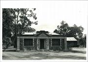
Chittering Road Board Offfice (Fmr) is a one story stone and corrugated iron building showing characteristics of Inter War Free Classical c.1915 - c. 1940 architectural style. Chittering Road Board Office (fmr) is located on Great Northern Highway, a few hundred metres south of Tee Tree Road in Chittering, opposite Chittering Lake. The former works foreman dwelling (c. 1957, c. 1976) is located in close proximity on the south side in the vicinity of the site of the Chittering Hall. At the rear of the building (west) there is the former works depot (c. 1951) and a donga which has been located on the site in recent years. A large open plan area to the north west of the building is the site of the former Chittering sports ground. There are no plantings of any significance on the site. Chittering Road Board Office (fmr) displays characteristics of the Inter Was Free Classical .c 1915 – c. 1940 architectural style described in ‘Identifying Australian Architecture’. Typical of the widely distributes style, the building has a symmetrical façade, a vestigial pediment, pilasters and classical elements introduced into an otherwise very simple exterior. Chittering Road Board Office (fmr) is a one storey hipped roof building with a symmetrical parapeted front with a central classical entry with pilasters and a pediment. The building is domestic in scale and style on the remaining three facades and the interior. The interior comprises a central corridor that opens onto one room each side exits onto a rear return verandah. It is constructed in randomly laid local laterite stone and detailed in rendered cement. The front wall is detailed in rendered stucco. The external corners of the front façade are rendered with horizontal incised bands on the quoined pilaster corners. The windows and entry recess have rendered quoined reveals. The capital across the width of the building, from window head height is rendered and has relief writing. The parapet has a stepped centre above the entry pediment which has a decorative floral relief design. The original 35 degree roof is a hipped roof which extends over the rear verandah to form a skillion, and has a box gutter along the front parapet. The roof is clad with the original short sheets of corrugated iron, with some evidence of rusting. Two corbelled face brick chimneys remain intact on the roof. The rear return verandah has an unlined roof , timber floor and square 100 x 100 milled jarrah posts. The interior has the original timber floors, hard plaster walls and ceilings in the original plasterboard with exposed flat battens. The two sets of windows on the front façade are the only windows in the building. Each set of windows has four casement windows with a fixed light above. The doors are original fabric with hardware still I place. Both fanlights above the external doors have amber patterned glass original panels. The timber doors are all four panelled and the front door has a letter slot. The two original fireplaces have been retained with the mantelpieces, the south room also has the original fire grate. The electricity has been disconnected.
Assessment: 2000 Construction: 1929 In 1871, the Chittering Valley district came under the jurisdiction of the newly formed Swan Road Board. In 1893, the Chittering District was included in the newly formed Gingin Road Board, until 1896 when the Chittering Brook Road Board was formed. The first meetings were held in Mooliabeenie. By 1903, Chittering Agricultural Hall and adjacent sports ground provided a centre for the district, and was considered an appropriate site to construct the road board offices in 1929. The Chittering Road Board Office was completed by June 1930. In 1938, the adjacent Chittering Hall was demolished and a new hall was constructed in Bindoon. In 1951 it was suggested that the Road Board office should be at the Bindoon Hall and residences built in Bindoon for employees. During 1957, a dwelling was built for the works foreman, in close proximity to the road board office in Chittering. After the Shire of Chittering came into being in 1961, the shire continued to occupy the Chittering Road Board Office, but a new building was planned for Bindoon where a townsite had since developed. In 1963, by the time the new Shire offices in Bindoon opened, the former Road Board building was in bad state of repair and became vacant. In 1966 tenders were called twice, with the same respondent each time, who was rejected. The Shire of Chittering sold the property in 1976, into private ownership. During that period of ownership, the place was used as a dwelling. In 1998, the Shire of Chittering purchased the vacant Chittering Road Board Office (fmr) and called for expressions of interest from community groups to use the building. The Bindoon Arts & Crafts group successfully tendered, outlining a proposal to develop the site as an arts and craft centre, tourist facility, museum and child care facility. In 1999, the Shire of Chittering received $20,000 for the building restoration from Centenary of Federation funding. The conservation works commenced in April 2000.
The original design and functional intention of the place is very clear. No additions or alterations have taken place. Although it is not possible to reinstate the original function, the place has a high integrity and authenticity. There has been a lack of maintenance over a period of many years and cumulative effects of weathering on external elements, Similarly, the interior has been neglected but maintained at a functional level. Overall the place is in fair condition.
This information is provided voluntarily as a public service. The information provided is made available in good faith and is derived from sources believed to be reliable and accurate. However, the information is provided solely on the basis that readers will be responsible for making their own assessment of the matters discussed herein and are advised to verify all relevant representations, statements and information.
Constructed from 1926
The site is significant for the social and recreational events that took place and the associations with generations of Chittering people. The place is associated with the beginnings of the civic administration in what is now the Chittering Shire, and civic leaders from 1930 to c1960.
Stone wall construction & rendered quoins. The gambrel roof is clad with corrugated iron
On 21 March 1893, the original Gingin Road Board was formed. It incorporated the areas of Chittering, Bindoon and Muchea. In November 1895, Bindoon and Chittering moved to form a separate road board. Board meetings took place in the homes of the various road board members, and at the Secretary's house. J Kay was an inaugural Councillor of the Chittering Road Board in 1896, at which time William C. Martin was Secretary. The Chittering Hall and oval were the site of many community gatherings in Chittering between 1900 and 1938. The timber framed and iron clad hall was the focus of weddings, weekly dances, the annual exhibition, and social events. In 1908, Alex Morley took over as the Road Board Secretary, and E. H. Morley took over the position from 1918 to 1926. In 1920, friction developed between the Gingin and Chittering Road Boards, after the Muchea residents requested that the Chittering Road Board administer their area. Consequently the Chittering Road Board forfeited the area along the Mooliabeenie Gingin Rd in exchange for the town of Muchea. (1923) In 1926, the Chittering Road Board office was built near the Chittering Hall. In 1938, architect C. L. E. Harrison called for tenders for the demolition of the hall and transport to Bindoon for reconstruction as the Bindoon Hall. The Shire of Chittering sold the place when they built new offices in Bindoon.
Integrity: Redeemable Authenticity: High Degree
Fair
| Ref ID No | Ref Name | Ref Source | Ref Date |
|---|---|---|---|
| "Newspaper Article" | Chittering Times | 8 October 1996 | |
| Udell H; "A History of Gingin 1830 to 1960". p. 161 | Gingin Shire Council | 1979 |
| Owner | Category |
|---|---|
| Shire of Chittering | Local Gov't |
This information is provided voluntarily as a public service. The information provided is made available in good faith and is derived from sources believed to be reliable and accurate. However, the information is provided solely on the basis that readers will be responsible for making their own assessment of the matters discussed herein and are advised to verify all relevant representations, statements and information.