Local Government
Manjimup
Region
South West
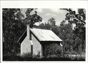
222 Rockbridge Rd Upper Warren
Manjimup
South West
Constructed from 1865
| Type | Status | Date | Documents |
|---|---|---|---|
| Heritage List | Adopted | 08 Dec 2016 | |
| State Register | Registered | 13 Oct 2019 | HCWebsite.Listing+ListingDocument, HCWebsite.Listing+ListingDocument |
| Type | Status | Date | Documents |
|---|---|---|---|
| (no listings) |
| Type | Status | Date | Grading/Management | |
|---|---|---|---|---|
| Category | ||||
| Classified by the National Trust | Classified | 07 Sep 1987 | ||
| Register of the National Estate | Indicative Place | 09 Aug 1988 | ||
| Municipal Inventory | Adopted | 10 Jul 1997 | Category A | |
Rockbridge, Upper Warren, comprising a hand-split two-roomed timber slab and shingled Slab Hut (c.1870;1918), the remnants of a stone Bread Oven, and an enclosing timber post and rail Fence located in its original rural setting overlooking a tributary of the Warren River, has cultural heritage significance for the following reasons: the place is a rare extant example of a modest hand-split timber slab hut with a shingled roof originally erected in the nineteenth and early twentieth century; the place demonstrates the hardships experienced in the south-west of the State during the period and the ways that people adapted in order to survive, which involved reliance on natural resources; and, the place is a good representative example of the practice of constructing timber slab huts in the south-west of the State where timber was prolific and people sourced material directly from the natural environment.
Rockbridge, Upper Warren is timber framed and has a hand cut timber shingle roof. The roof is capped with galvanised iron which appears in fair condition, with some rusting visible. The frame comprises regularly spaced square timber posts infilled with butt jointed timber slabs, which are nailed to a timber top and bottom rail. Internally timber battens are fixed vertically over the gaps between the slabs. Slabs vary from approximately 200-400mm in width, and extend the full height of the Hut. The roof structure is comprised of a central ridge beam, rafters and collar ties, this is exposed internally. Some light can be seen coming through gaps in the timber shingles however there is no evidence of water ingress in the hut. A square galvanised iron gutter runs either side of the chimney, no downpipes are present. A rubble granite stone chimney extends from the west façade and is in good condition. A ruinous granite stone Bread Oven is located at the base of a mature tree to the west of the Hut, just beyond the fence.
By the 1870s there were many families established in the region, following the influx of convicts and ticket-of-leave men during the convict period (1850-1868), and a small local community had been established. By this time John Mottram had several large leases of land in the area, including a portion of land where Rockbridge, Upper Warren is located and it is believed a small slab hut had been established, comprising one room. An outside stone bread over may also have been erected during this time located to the west of the Slab Hut, which remains in a ruinous condition. A 1890s survey of the Nelson district shows that, in the area surrounding Rockbridge, Upper Warren, John Mottram owned or was leasing approximately 20,000 acres of land, with a very small portion under cultivation adjacent to Smith Brook and close to the area where Rockbridge, Upper Warren is extant.19 From this survey, no structures for any properties are shown, but it is likely that structures were erected on the site as someone needed to reside at the property in order to meet the conditions of ‘Conditional Purchasing’ of land. In a 1912 newspaper article John James, his brother David, and a neighbour, requested the Roads Board upgrade the road to Rockbridge, Upper Warren.20 By 1914, these roadworks were almost complete.21 In 1919, the first certificate of title was issued for the land on which the place now stands,22 indicating the land was now privately owned rather than leased. In c.1918, the eastern portion of the Slab Hut was constructed to cater for John James Mottram and his family. Clive Mottram, who lived in the place until he was about 5 years old, reminisces that the construction of the eastern portion coincided with his brother being a small child (c.1918). From this time, Rockbridge, Upper Warren was established as a pastoral enterprise, which ran dairy cattle (Guernsey/Shorthorn) and sheep (Romney Marsh). At its most productive, the farm was milking up to 130 cows per day. The milk was being transported to a butter factory in Manjimup and cream was processed on site with a cream truck collecting the product several times a week.27 The dairy industry in the State during the early twentieth century boomed as settlers in the south-west associated with the Group Settlement Scheme and private enterprises around the metropolitan area supplied dairy products to the various distribution centres; by c.1930, in a single year, upwards of 1,000 applications were applied to distribute milk. By c.1926, a new, grander farmhouse had been erected by John James to the north of the original slab hut. The family moved into the new house and the slab hut was used to accommodate workers employed on the farm. By c.1980, the place was in an almost ruinous state. However, this allowed Cliff and his son, David, to observe the construction methods that would have otherwise been hidden. The historical importance and significance of the place to the Mottram family was realised and it was decided to restore the slab hut to its original state.
Individual Building or Group
| Epoch | General | Specific |
|---|---|---|
| Original Use | RESIDENTIAL | Single storey residence |
| Present Use | RESIDENTIAL | Single storey residence |
| Type | General | Specific |
|---|---|---|
| Wall | TIMBER | Slab |
| General | Specific |
|---|---|
| DEMOGRAPHIC SETTLEMENT & MOBILITY | Settlements |
This information is provided voluntarily as a public service. The information provided is made available in good faith and is derived from sources believed to be reliable and accurate. However, the information is provided solely on the basis that readers will be responsible for making their own assessment of the matters discussed herein and are advised to verify all relevant representations, statements and information.
Constructed from 1865
Representativeness, Aesthetic, Rarity and Historic
The old house stands on a slight rise overlooking a small stream which joins the Warren River. Nearby is the twentieth century family residence. The simple rectangular building originally consists of three rooms with vertical jarrah slab walls resting on a log foundation plate with corner posts morticed into the plate. The hipped roof is constructed of timber shingles. A stone fireplace at the west end has also been restored. There are two doors and two timber framed windows in the front elevation. The house is surrounded by an old post and rail fence.
Rockbridge is the Mottram family property. John Mottram was one of a group of early pioneers who settled in a community on the Warren River just north of the Karri forest. The others were Arthur Clarke (Fern Hollow), Walter Blechynden, and Peter Wheatley (Clover Cottage). The four families were responsible for the building of nearby St Mark’s Anglican Church which was also used as a school for the local children between 1891 and 1920. This timber cottage is thought to have been built C1865, although one source suggests this is a later building replacing an earlier building closer to the river. Nearby is a more modern residence where the Mottram family currently lives. The old house was last occupied in the 1920s. During the 1990s the timber building was carefully and lovingly restored by the Mottrams in the late 1990s, and it is now a fine example of an early pioneer residence. Graham Robinson, a local builder specializing in old timber buildings, did a lot of the work. The interior has also been restored and the house has been furnished with family treasures and artefacts of the period, some of which were found on the farm. Cliff Mottram, the current owner, now 85, said he was born and lived in the house until he was about five. The family then moved into the new house in the 1920s. The old rock bridge after which the property is named, has been covered over with a causeway.
Integrity: Very Good Authenticity: Very Good
Good
| Ref ID No | Ref Name | Ref Source | Ref Date |
|---|---|---|---|
| Heritage and Conservation Professionals: "Shire of Manjimup Municipal Heritage Inventory". | Shire of Manjimup | 1995 Adopted 1997 | |
| National Trust Assessment form | National Trust of Australia WA | 1987 |
This information is provided voluntarily as a public service. The information provided is made available in good faith and is derived from sources believed to be reliable and accurate. However, the information is provided solely on the basis that readers will be responsible for making their own assessment of the matters discussed herein and are advised to verify all relevant representations, statements and information.
Rockbridge, like Dingup and Springdale represents a second generation homestead built in the 1890s. It is significant as a ruin which has already been partly restored. The skeleton structure has revealed the nature of the craftmanship and the methods of joinery originally used. Old timbers from the house have been saved and timbers from the old sheds have been collected by Mr Mottram and his son who have carried out careful reconstruction where necessary, using the old timbers as patterns for the new material. The old house stands on a slight rise overlooking a small stream which joins the Warren River. The original homestead was built on a riverside flat with the Warren River flowing past on the west. Nearby is the twentieth century residence.
The house originally consisted or three rooms with vertical jarrah slab walls resting on a log foundation plate with corner posts morticed into the plate. The roof skeleton also remains and a stone fireplace as at the west end and is being restored.
Assessment 1987 Construction 1860 - 1870
This information is provided voluntarily as a public service. The information provided is made available in good faith and is derived from sources believed to be reliable and accurate. However, the information is provided solely on the basis that readers will be responsible for making their own assessment of the matters discussed herein and are advised to verify all relevant representations, statements and information.
South Western Hwy Upper Warren
Manjimup
South West
Constructed from 1895
| Type | Status | Date | Documents |
|---|---|---|---|
| Heritage List | Adopted | 08 Dec 2016 |
| Type | Status | Date | Documents |
|---|---|---|---|
| (no listings) |
| Type | Status | Date | Grading/Management | |
|---|---|---|---|---|
| Category | ||||
| Municipal Inventory | Adopted | 10 Jul 1997 | Category B | |
| Classified by the National Trust | Classified | 07 Sep 1987 | ||
| Register of the National Estate | Nominated | 19 Feb 1991 | ||
| Register of the National Estate | Indicative Place | |||
| Name | Type | Year From | Year To |
|---|---|---|---|
| Mottram, John | Architect | - | - |
Individual Building or Group
| Epoch | General | Specific |
|---|---|---|
| Original Use | RESIDENTIAL | Single storey residence |
| Present Use | RESIDENTIAL | Single storey residence |
This information is provided voluntarily as a public service. The information provided is made available in good faith and is derived from sources believed to be reliable and accurate. However, the information is provided solely on the basis that readers will be responsible for making their own assessment of the matters discussed herein and are advised to verify all relevant representations, statements and information.
Constructed from 1895
Representativeness, Aesthetic, Rarity and Historic
The building is a single storied house constructed of split slabs placed vertically in two tiers. The slabs are held in place with horizontal plates. The pitched hip roof forms an encircling verandah around the house and is covered with Colourbond corrugated iron. Modern gutters have also been attached. A portion of the verandah has been bricked in to form a room. The front elevation has three doors and three timber frames windows opening onto the verandah. The ceiling is lathe and plaster. Nearby on the property is a distinctive toilet constructed with a timber frame and covered with wooden shingles.
Riverdale was originally owned by John Mottram who had managed the Manjimup property when he first came to the district. It is a good example of an early settler dwelling, using the most readily available building materials, in this case timber. This type of construction was used by settlers in their first home and was usually replaced at a later stage when the farmer became more affluent. Vertical and horizontal timber slab construction was an easily utilized method of construction for early settlers. The type of construction used at Riverdale is unusual for this region. Short slabs were placed between top middle and bottom plates, forming two tiers of slabs. One of the previous owners was Graham Robinson, who is known in the area for his skills and expertise in restoring old timber houses. He was also involved in the restoration of Rockbridge in the late 1990s.
Integrity: Good Authenticity: Good
Good
| Ref ID No | Ref Name | Ref Source | Ref Date |
|---|---|---|---|
| Heritage and Conservation Professionals: "Shire of Manjimup Municipal Heritage Inventory". | Shire of Manjimup | 1995 Adopted 1997 |
This information is provided voluntarily as a public service. The information provided is made available in good faith and is derived from sources believed to be reliable and accurate. However, the information is provided solely on the basis that readers will be responsible for making their own assessment of the matters discussed herein and are advised to verify all relevant representations, statements and information.
The building is another example of the simple domestic architectural style of the 1870's. This house is important as it contributes to the social history of the district and demonstrates the way of life of the pioneers of this period. John Mottram who managed the Manjimup House property in the 1860's was the original owner.
This building is a single storied colonial slab house, with a ptiched roof and a verandah, part of which has been made into a room. The roof has been recently covered with colourbond corrugated iron and modern gutters have been attached. Items of interest include 3 windows and 3 doors opening onto the front verandah. The walls are composed of a timber frame infilled with slabs in two tiers.
Assessment 1987 Construction 1890/1900
This information is provided voluntarily as a public service. The information provided is made available in good faith and is derived from sources believed to be reliable and accurate. However, the information is provided solely on the basis that readers will be responsible for making their own assessment of the matters discussed herein and are advised to verify all relevant representations, statements and information.
Wheatley Coast Rd Upper Warren
Includes: Shed & Outdoor Living Area
Manjimup
South West
Constructed from 1875
| Type | Status | Date | Documents |
|---|---|---|---|
| Heritage List | Adopted | 08 Dec 2016 |
| Type | Status | Date | Documents |
|---|---|---|---|
| (no listings) |
| Type | Status | Date | Grading/Management | |
|---|---|---|---|---|
| Category | ||||
| Classified by the National Trust | Classified | 07 Sep 1987 | ||
| Register of the National Estate | Nominated | 09 Aug 1988 | ||
| Register of the National Estate | Indicative Place | |||
| Municipal Inventory | Adopted | 10 Jul 1997 | Category B | |
Individual Building or Group
| Epoch | General | Specific |
|---|---|---|
| Present Use | RESIDENTIAL | Single storey residence |
| Original Use | RESIDENTIAL | Single storey residence |
This information is provided voluntarily as a public service. The information provided is made available in good faith and is derived from sources believed to be reliable and accurate. However, the information is provided solely on the basis that readers will be responsible for making their own assessment of the matters discussed herein and are advised to verify all relevant representations, statements and information.
The building in its context in the Shore of Manjimup is an example of the simple domestic architectural style of the 1870's. The building, as the former home of the Wheatley family contributes to the social history of the period and is important as an example of a particular way of life. The original pastoral license for the land where Clover Cottage stands was made to Peter Wheatley in 1874.
The building consists of a single storied English bonded brick house, with a pitched roof and a verandah almost all the way around. There is a timber addition - a kitchen - attached at the back. The whole is covered in corrugated iron over the jarrah shingles. Pit sawn timber was used throughout, including the floors, doors and windows. Originally the ceilings in the main living rooms followed the line of the roof - the bedrooms are an example of this. Some of the wooden sheds and yards still remain.
Assessment 1987 Construction 1870 - 1875 Architect: Jack Haines
This information is provided voluntarily as a public service. The information provided is made available in good faith and is derived from sources believed to be reliable and accurate. However, the information is provided solely on the basis that readers will be responsible for making their own assessment of the matters discussed herein and are advised to verify all relevant representations, statements and information.
Constructed from 1875
Aesthetic, Representativeness, Rarity and Historic
· This low, single storey English bonded brick house is located in a rural setting; · The pitched roof is corrugated iron over shingles; · A verandah under the main roof surrounds most of the house and is supported by timber posts; · Pit sawn timber was used throughout the building, including the floors, doors and windows, and; · The two tall brick chimneys are prominent.
Clover Cottage was built by Jack Haines in 1875 for the Wheatley family. Peter Wheatley arrived from Ireland in 1862 and was for a time associated with the Lefroys of Karri Hill. Wheatley was one of a group of early pioneers who settled in a community on the Warren River just north of the Karri forest. The others were Arthur Clarke (Fern Hollow), John Mottram (Rockbridge) and Walter Blechynden. The four families were responsible for the building of nearby St Mark’s Anglican Church which was also used as a school for the local children between 1891 and 1920. Jack Haynes built the church, as well as Fern Hollow, Clover Cottage and Dingup Church. Wheatley was granted the original pastoral license for the Clover Cottage property in 1874 and the residence was built by the following year. The Wheatleys had 14 children.
Integrity: Very good Authenticity: Very Good
Good
| Ref ID No | Ref Name | Ref Source | Ref Date |
|---|---|---|---|
| Heritage and Conservation Professionals: "Shire of Manjimup Municipal Heritage Inventory". | Shire of Manjimup | 1995 Adopted 1997 | |
| Clover Cottage Country Retreat Brochure | Clover Cottage | 2004 | |
| National Trust of Australia WA Assessment | National Trust of Australia WA | 1987 |
This information is provided voluntarily as a public service. The information provided is made available in good faith and is derived from sources believed to be reliable and accurate. However, the information is provided solely on the basis that readers will be responsible for making their own assessment of the matters discussed herein and are advised to verify all relevant representations, statements and information.
Wheatley Coast Rd Upper Warren
c.500m east of Wheatley Coast Rd. c.1km south of Muirs Hwy
Upper Warren School
Manjimup
South West
Constructed from 1891
| Type | Status | Date | Documents |
|---|---|---|---|
| Heritage List | Adopted | 08 Dec 2016 | |
| State Register | Registered | 14 Dec 2001 | HCWebsite.Listing+ListingDocument, HCWebsite.Listing+ListingDocument |
| Type | Status | Date | Documents |
|---|---|---|---|
| (no listings) |
| Type | Status | Date | Grading/Management | |
|---|---|---|---|---|
| Category | ||||
| Register of the National Estate | Nominated | 09 Aug 1988 | ||
| Register of the National Estate | Indicative Place | |||
| Classified by the National Trust | Classified | 07 Sep 1987 | ||
| Municipal Inventory | Adopted | 10 Jul 1997 | Category A+ | |
Individual Building or Group
| Epoch | General | Specific |
|---|---|---|
| Present Use | EDUCATIONAL | Combined School |
| Original Use | RELIGIOUS | Church, Cathedral or Chapel |
| Style |
|---|
| Vernacular |
| Type | General | Specific |
|---|---|---|
| Roof | TIMBER | Shingle |
| Wall | BRICK | Common Brick |
| Roof | METAL | Zincalume |
| General | Specific |
|---|---|
| DEMOGRAPHIC SETTLEMENT & MOBILITY | Settlements |
| SOCIAL & CIVIC ACTIVITIES | Education & science |
| SOCIAL & CIVIC ACTIVITIES | Religion |
This information is provided voluntarily as a public service. The information provided is made available in good faith and is derived from sources believed to be reliable and accurate. However, the information is provided solely on the basis that readers will be responsible for making their own assessment of the matters discussed herein and are advised to verify all relevant representations, statements and information.
The old (brick) Upper Warren School (weekdays) and church (occasional Sundays) stands as a memorial to the community life of more than a century ago in a community on the Warren River just north of the Karri Forest. The earliest Warren settlers, Arhtur Clarke, Walter Blechynden (Glenpennant), John Mottram (Peppermint Grove) and Peter Wheatley (Clover Cottage) in 1883 arranged with a ticket- of -leave builder to erect a school at a site midway from the farms so that the children would have only about 2 miles to walk (or ride). Thet agreed to take turns, each boarding the teacher for three months. The builder made the bricks, and built a room with a fireplace and chimney at one end and door at the other with a porch (2m x x2.5m) with bench seats at either side to serve as a shelter shed. It was roofed with shingles later covered with corrugated iron. The setting of the school and its tiny playground, surrounded by the tall forest, conveys the impression of the isolation of a small group of farmers. More than 100 years old, the school is the only remaining school of the period in the district.
One roome (5m x 6m) of brick (english bond) with fireplace and chimney at one end and door at the other with a porch (2m x x2.5m) with bench seats at either side. Floor - Jarrah; steep pitched roof, corrugated iron over shingles. Since about 1920 until recently it has been used as a church only. School desks have been converted to pews by removing desktops. Holes for inkwells and pencils still remain. The altar stands before the fireplace which is covered by a cloth drape.
Assessment 1987 Construction 1883 Architect: J Haynes Builder: ticket of leave man
This information is provided voluntarily as a public service. The information provided is made available in good faith and is derived from sources believed to be reliable and accurate. However, the information is provided solely on the basis that readers will be responsible for making their own assessment of the matters discussed herein and are advised to verify all relevant representations, statements and information.
Constructed from 1883
Representativeness, Aesthetic, Rarity, Social and Historic
· Building is located 700 metres off the Wheatley Coast road along a winding bush track; · Rectangular, one roomed building; · Soft clay bricks; · English bond construction; · Steeply pitched roof; · Zincalume roof over jarrah shingles; · Fireplace and chimney at one end; · Interior walls plastered; · Jarrah floor; · Timber window frames; · Timber framed entry porch; · Arched entrance opening; · Painted weatherboard cladding and zincalume roof; · Evidence of severe cracking and repairs to building; · 30 metres south of building is a timber lined well with large flitches of timber for a well cover, and; · Two rail split rail fence around the church.
The old Upper Warren School, now St Marks Anglican Church, is a memorial to the pioneers who settled in a community on the Warren River just north of the Karri forest. The earliest Upper Warren Settlers, Arthur Clarke, Walter Blechynden, John Mottram (Rockbridge) and Peter Wheatley (Clover Cottage) arranged with a ticket-of-leave builder, Jack Haines (Haynes), to erect a school at a site midway from the farms so that the children would have only about 2 miles to walk or ride. A plaque on the building indicates that the building was constructed in 1883, while the Heritage Council Assessment of 2001 quotes 1891 as the construction date. The building was also intended to serve as a church and social centre for the district. Clay for the bricks was found near the school site and bricks were made there and then carted by bullock dray to the school site, as were stones for the foundations of the building. The timber required was pit sawn nearby and jarrah shingles for the roof were split in the adjoining bush. The cost of all materials and the labour was shared between the families. A well was sunk at a short distance from the building with two timber slabs as a cover. The school was opened on 1 July 1891 with Kate Logue as schoolmistress, and an enrolment of four boys and 14 girls. The cost of the teacher’s salary was shared among the children’s parents, and each of the four families boarded the teacher for three months at a time. From the outset, the place served as both school and church, and the first wedding was celebrated there on 14 September 1891, when the Reverend J Brand married Charles Simpson and Emily Reeve, both of Deeside. The place continued to serve as both school and church until the 1920s when a new school was build and use of the place for that purpose ceased. The school desks were converted to pews by removal of the desktops and remained in use at the place. In 1929 the place was dedicated as a church, St Mark’s Anglican Church, Upper Warren. In 1955 various works were carried out , including replastering and painting of the internal walls, and fitting of a new corrugated iron roof, leaving the original shingles beneath. St Thomas Church at Dingup donated the altar as a gift to celebrate the consecration of the church in 1955. New curtains were made for the altar and the organ was donated by Stan Parsons, a descendant of the Wheatley family. The building serves as a church until the mid 1980s when regular church services at the place ceased. In 1986 a Historic Day was held, which was attended by many residents and past residents of the district. Various repair works were carried out. In September 1987 the place was classified by the National Trust and in September 1992 the place was placed on the Interim Register of the State Register of Heritage Places. In 1993 repairs and maintenance were carried out including a replacement corrugated iron roof, which left the shingles intact beneath the new roof. A ‘Back to Warren’ day was subsequently held at the place. In February 1994 a Memorial was registered on the place under the Heritage of Western Australia Act 1990. In 1997 the place was included in the Shire of Manjimup’s Municipal Heritage Inventory. In 2001 the place was maintained as far as possible by the Church Trustees. The original lectern Pews, organ and other furniture remain at the place. The place is valued by the local residents as a significant part of the history of the district and continues to be used on an occasional basis.
Integrity: Good Authenticity: Good
Fair
| Ref ID No | Ref Name | Ref Source | Ref Date |
|---|---|---|---|
| National Trust Assessment Form | National Trust of Australia WA | 1987 | |
| Heritage and Conservation Professionals: "Shire of Manjimup Municipal Heritage Inventory". | Shire of Manjimup | 1995 Adopted 1997 | |
| Heritage Council Assessment form | Heritage Council WA |
This information is provided voluntarily as a public service. The information provided is made available in good faith and is derived from sources believed to be reliable and accurate. However, the information is provided solely on the basis that readers will be responsible for making their own assessment of the matters discussed herein and are advised to verify all relevant representations, statements and information.

Wheatley Coast Rd Upper Warren
Upper Warren School
Manjimup
South West
Constructed from 1920
| Type | Status | Date | Documents |
|---|---|---|---|
| (no listings) |
| Type | Status | Date | Documents |
|---|---|---|---|
| (no listings) |
| Type | Status | Date | Grading/Management | |
|---|---|---|---|---|
| Category | ||||
| Municipal Inventory | Adopted | 10 Jul 1997 | Category C | |
| Classified by the National Trust | Classified | 07 Sep 1987 | ||
| Register of the National Estate | Indicative Place | |||
Individual Building or Group
| Epoch | General | Specific |
|---|---|---|
| Present Use | SOCIAL\RECREATIONAL | Other Sports Building |
| Original Use | EDUCATIONAL | Combined School |
| General | Specific |
|---|---|
| SOCIAL & CIVIC ACTIVITIES | Sport, recreation & entertainment |
This information is provided voluntarily as a public service. The information provided is made available in good faith and is derived from sources believed to be reliable and accurate. However, the information is provided solely on the basis that readers will be responsible for making their own assessment of the matters discussed herein and are advised to verify all relevant representations, statements and information.
Constructed from 1924
Representativeness, Social, Aesthetic and Historic
Located in a rural setting, surrounded by undulating farm and forest country, this building, constructed of weatherboard and asbestos, is rectangular in design and has a pitched, corrugated iron roof. The floors are timber, and there are three windows on each side of the building. The entry door was in the front from the open porch-way. Since the building has become a hall and recreational centre, the porch is now enclosed with asbestos. There is one window and the entry door is relocated to the side. Tennis courts were constructed later than the building – the first having been built in 1927.
The earliest settlers in the Upper Warren District were Arthur Clarke (Fern Hollow), Walter Blechynden, John Mottram (Rockbridge) and Peter Wheatley (Clover Cottage). The four families were responsible for the building of St Mark’s Anglican Church which was also used as a school for the local children between 1891 and 1920. Jack Haynes built the church, as well as Fern Hollow, Clover Cottage and Dingup Church. This building was constructed around 1924, as a replacement for the ‘local ‘school’ conducted at nearby St Mark’s Anglican Church. It served as the school until 1942. It was also used as a hall and recreational centre for the district. The tennis courts were a later addition. One source dates the courts as built in the 1940s, while a sign at the site indicates that the first court was built in 1927.
Integrity: Fair Authenticity: Fair
Fair
| Ref ID No | Ref Name | Ref Source | Ref Date |
|---|---|---|---|
| Heritage and Conservation Professionals: "Shire of Manjimup Municipal Heritage Inventory". | Shire of Manjimup | 1995 Adopted 1997 |
| Owner | Category |
|---|---|
| Shire of Manjimup | Local Gov't |
This information is provided voluntarily as a public service. The information provided is made available in good faith and is derived from sources believed to be reliable and accurate. However, the information is provided solely on the basis that readers will be responsible for making their own assessment of the matters discussed herein and are advised to verify all relevant representations, statements and information.
This information is provided voluntarily as a public service. The information provided is made available in good faith and is derived from sources believed to be reliable and accurate. However, the information is provided solely on the basis that readers will be responsible for making their own assessment of the matters discussed herein and are advised to verify all relevant representations, statements and information.
Young Rd Upper Warren
Clarke's Homestead
Manjimup
South West
Constructed from 1880
| Type | Status | Date | Documents |
|---|---|---|---|
| (no listings) |
| Type | Status | Date | Documents |
|---|---|---|---|
| (no listings) |
| Type | Status | Date | Grading/Management | |
|---|---|---|---|---|
| Category | ||||
| Classified by the National Trust | Classified | 07 Sep 1987 | ||
| Register of the National Estate | Nominated | 09 Aug 1988 | ||
| Register of the National Estate | Indicative Place | |||
| Municipal Inventory | Adopted | 10 Jul 1997 | Category B | |
| Name | Type | Year From | Year To |
|---|---|---|---|
| Clarke, Arthur Lewin | Architect | - | - |
Individual Building or Group
| Epoch | General | Specific |
|---|---|---|
| Present Use | FARMING\PASTORAL | Homestead |
| Original Use | FARMING\PASTORAL | Homestead |
| Type | General | Specific |
|---|---|---|
| Wall | BRICK | Rendered Brick |
| General | Specific |
|---|---|
| OCCUPATIONS | Grazing, pastoralism & dairying |
This information is provided voluntarily as a public service. The information provided is made available in good faith and is derived from sources believed to be reliable and accurate. However, the information is provided solely on the basis that readers will be responsible for making their own assessment of the matters discussed herein and are advised to verify all relevant representations, statements and information.
Constructed from 1880
Representativeness, Social and Historic
· Simple rectangular building; · Hipped, corrugated iron roof with a broken back; · Single chimney; · Brick walls rendered and white washed; · Small porch added on the back elevation; · Narrow verandah extends across the front elevation; · Timber doors and window frames, and; · Barn and machinery shed near the house.
This is one of the four original homesteads which constituted the Upper Warren Settlement which was established in the late eighteen seventies and early eighteen eighties. The house was built by Arthur Levin Clarke, who came from Harvey and married Emma Giblett of Balbarrup in 1875. He engaged a ticket-of-leave builder, Jack Haynes (Haines), to make bricks and to construct a house on Nelson Location 74 (40 acres) which was originally taken up by John Mottram of Manjimup. Clarke commenced farming on a small clearing surrounded by the bush where they pastured their cattle. The other early pioneers in the area were Blechynden, Mottram and Wheatley. The four families were responsible for the building of nearby St Mark’s Anglican Church which was also used as a school for the local children between 1891 and 1920. Jack Haynes built the church, as well as Fern Hollow, Clover Cottage and Dingup Church. Since 1940 the Young family has owned the property, which is locally known as Young’s place.
Integrity: Good Authenticity: Good
Good
| Ref ID No | Ref Name | Ref Source | Ref Date |
|---|---|---|---|
| National Trust Assessment Form | National Trust of Australia WA | 1987 | |
| Heritage and Conservation Professionals: "Shire of Manjimup Municipal Heritage Inventory". | Shire of Manjimup | 1995 Adopted 1997 |
This information is provided voluntarily as a public service. The information provided is made available in good faith and is derived from sources believed to be reliable and accurate. However, the information is provided solely on the basis that readers will be responsible for making their own assessment of the matters discussed herein and are advised to verify all relevant representations, statements and information.