Local Government
Busselton
Region
South West
Cape Naturaliste
a peninsula extending from Canal Rocks along Caves Rd to the east of Dunsborough. To the west is the open Indian Ocean, and to the North is Geographe Bay
Leeuwin - Naturaliste Ridge Area
Busselton
South West
| Type | Status | Date | Documents |
|---|---|---|---|
| (no listings) |
| Type | Status | Date | Documents |
|---|---|---|---|
| (no listings) |
| Type | Status | Date | Grading/Management | |
|---|---|---|---|---|
| Category | ||||
| Classified by the National Trust | Classified {Lscpe} | 11 Mar 1985 | ||
| Register of the National Estate | Registered | 21 Mar 1978 | ||
The place is in good condition except for the townsites. The coastline system is fragile.
Landscape
| Epoch | General | Specific |
|---|---|---|
| Original Use | FARMING\PASTORAL | Other |
| Present Use | PARK\RESERVE | Park\Reserve |
| Original Use | OTHER | Other |
| General | Specific |
|---|---|
| PEOPLE | Early settlers |
| PEOPLE | Aboriginal people |
This information is provided voluntarily as a public service. The information provided is made available in good faith and is derived from sources believed to be reliable and accurate. However, the information is provided solely on the basis that readers will be responsible for making their own assessment of the matters discussed herein and are advised to verify all relevant representations, statements and information.
The Cape Naturaliste Area, approximately 24,000 hectares, has cultural heritage significance as a largely natural environment containing a diversity of flora and fauna, specifically eucalyptus and karri species native to the district. The area wields historical significance including that of Aboriginal importance due to use by early settlers.
The Cape Naturaliste Area is both publicly and privately owned and encompasses the Leeuwin Naturaliste National Park. The vast expanse of beaches, coastal headlands and cliffs also boasts a large number of limestone caves, and a diverse species of trees in particular, the magnificent karri forest. Some other natural features and historic buildings add to the visual richness of the area.
Historical Notes: Many ships have been known to be lost at Cape Naturaliste including ‘Carnavon Castle’ that caught fire of the coast in 1907. History has it that the 14 survivors floated in lifeboats for 27 days before they were rescued. The lighthouse keeper, Patrick Baird plucked them to safety and cared for them. The waters just off the coast have also been known to be treacherous to many other sailors alike.
The caves contain archaeologically important fossils.
Integrity Notes: The place retains a high degree of integrity except for the forest areas that retain a moderate degree of integrity. Authenticity Notes: The place retains a good degree of authenticity. High Degree/High Degree Forest: Moderate degree
Good- except for the townsites. The coastline is fragile.
| Ref ID No | Ref Name | Ref Source | Ref Date |
|---|---|---|---|
| http://www.southwestlife.com.au/history1201.htm |
| Owner | Category |
|---|---|
| Various | UNKNOWN |
This information is provided voluntarily as a public service. The information provided is made available in good faith and is derived from sources believed to be reliable and accurate. However, the information is provided solely on the basis that readers will be responsible for making their own assessment of the matters discussed herein and are advised to verify all relevant representations, statements and information.
Bunker Bay Cape Naturaliste
Busselton
South West
| Type | Status | Date | Documents |
|---|---|---|---|
| (no listings) |
| Type | Status | Date | Documents |
|---|---|---|---|
| (no listings) |
| Type | Status | Date | Grading/Management | |
|---|---|---|---|---|
| Category | ||||
| Municipal Inventory | Adopted | 20 Jun 1996 | Category 5 | |
The place is in good condition.
Landscape
| Epoch | General | Specific |
|---|---|---|
| Original Use | PARK\RESERVE | Park\Reserve |
| Present Use | PARK\RESERVE | Park\Reserve |
| General | Specific |
|---|---|
| OTHER | Other Sub-Theme |
| SOCIAL & CIVIC ACTIVITIES | Environmental awareness |
This information is provided voluntarily as a public service. The information provided is made available in good faith and is derived from sources believed to be reliable and accurate. However, the information is provided solely on the basis that readers will be responsible for making their own assessment of the matters discussed herein and are advised to verify all relevant representations, statements and information.
Lake Jingie, a freshwater lake in a natural setting, has cultural heritage significance as an early domestic water supply for Cape Farm. It remains to be a largely intact natural environment and one of the rare freshwater lakes around. It is closely associated with the nearby Cape Farm, established in 1862. The diversity of native flora and fauna adds to the scientific significance and rarity of the place.
Lake Jingie is a freshwater lake. The place once served as a source of domestic water supply and holds historic associations with the nearby Cape Farm established in 1862.
The place once served as a source of domestic water supply and holds historic associations with the nearby Cape Farm established in 1862.
High Degree/High Degree Integrity Notes: The place retains a high degree of integrity. Authenticity Notes: The place retains a high degree of authenticity.
Good
| Owner | Category |
|---|---|
| Estate of JL d'Espeissis & JI d'Espeissis | Other Private |
| Chemco Pty Ltd | Other Private |
This information is provided voluntarily as a public service. The information provided is made available in good faith and is derived from sources believed to be reliable and accurate. However, the information is provided solely on the basis that readers will be responsible for making their own assessment of the matters discussed herein and are advised to verify all relevant representations, statements and information.
Lot 422 Bunker Bay Rd Cape Naturaliste
Was part of Cape Farm Ruins before subdivision
Busselton
South West
| Type | Status | Date | Documents |
|---|---|---|---|
| (no listings) |
| Type | Status | Date | Documents |
|---|---|---|---|
| (no listings) |
| Type | Status | Date | Grading/Management | |
|---|---|---|---|---|
| Category | ||||
| (no listings) | ||||
Historic Site
| Epoch | General | Specific |
|---|---|---|
| Present Use | VACANT\UNUSED | Vacant\Unused |
| Original Use | VACANT\UNUSED | Vacant\Unused |
This information is provided voluntarily as a public service. The information provided is made available in good faith and is derived from sources believed to be reliable and accurate. However, the information is provided solely on the basis that readers will be responsible for making their own assessment of the matters discussed herein and are advised to verify all relevant representations, statements and information.
Cape Naturaliste Rd Cape Naturaliste
Busselton
South West
Constructed from 1896 to 1904
| Type | Status | Date | Documents |
|---|---|---|---|
| Heritage List | Adopted | 16 Oct 2024 | |
| State Register | Registered | 17 Apr 2003 | HCWebsite.Listing+ListingDocument, HCWebsite.Listing+ListingDocument |
| Type | Status | Date | Documents |
|---|---|---|---|
| (no listings) |
| Type | Status | Date | Grading/Management | |
|---|---|---|---|---|
| Category | ||||
| Municipal Inventory | Adopted | 20 Jun 1996 | Category 1 | |
| Local Heritage Survey | YES | 16 Oct 2024 | Category 1 | |
| Register of the National Estate | Permanent | 18 Apr 1989 | ||
| Survey of 20th Ctry Architecture | Completed | 01 Mar 1988 | ||
The place is in very good condition.
| Name | Type | Year From | Year To |
|---|---|---|---|
| State of WA (Vested Conservation Commission of WA) | Architect | - | - |
| CSR Palmer (WA Engineer-in-Chief) | Architect | 1896 | 1904 |
| Library Id | Title | Medium | Year Of Publication |
|---|---|---|---|
| 5195 | Opportunity to develop visitor accommodation, facilities and services at the Cape Leeuwin Lighthouse and Cape Naturaliste Lighthouse precincts : guidelines for submissions. | Report | 2001 |
| 5139 | Cape Naturaliste Lightstation : concept plan. | Report | 2001 |
| 5468 | Review of improvements to meet building code of Australia for the Cape Leeuwin and Cape Naturaliste lighthouses. | Report | 2001 |
| 3422 | Conservation Plan Cape Naturaliste Lightstation Western Australia | Heritage Study {Cons'n Plan} | 1992 |
| 7183 | Lighthouses of Australia : images from the end of an era. | Book | 2001 |
Individual Building or Group
| Epoch | General | Specific |
|---|---|---|
| Original Use | Transport\Communications | Water: Lighthouse |
| Present Use | Transport\Communications | Water: Lighthouse |
| Present Use | COMMERCIAL | Other |
| Original Use | Transport\Communications | Water: Housing or Quarters |
| Style |
|---|
| Vernacular |
| Victorian Georgian |
| Type | General | Specific |
|---|---|---|
| Wall | CONCRETE | Other Concrete |
| Wall | ASBESTOS | Fibrous Cement, corrugated |
| Wall | METAL | Cast Iron |
| Roof | METAL | Corrugated Iron |
| Wall | STONE | Limestone |
| Wall | TIMBER | Weatherboard |
| General | Specific |
|---|---|
| OUTSIDE INFLUENCES | Water, power, major t'port routes |
| TRANSPORT & COMMUNICATIONS | River & sea transport |
This information is provided voluntarily as a public service. The information provided is made available in good faith and is derived from sources believed to be reliable and accurate. However, the information is provided solely on the basis that readers will be responsible for making their own assessment of the matters discussed herein and are advised to verify all relevant representations, statements and information.
Constructed from 1904, Constructed from 1896
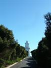
Cape Naturaliste Lighthouse and Quarters is a significant feature in the natural landscape. The bulky fence lines and the squat presence of the cottages, contrasts sharply with the natural, scrubby vegetation. Rising above all this is the pristine whiteness of the lighthouse tower, which appears almost isolated from the other features. In combination with the topography of the Cape, the place is a prominent visual landmark, especially from the ocean. Cape Naturaliste Lighthouse and Quarters was an important link in the development of coastal lights which eventually circled mainland Australia, following an inter-colonial conference held in 1873 that recognised the need for additional lights along the Australian coastline. The slower development of coastal lights in Western Australia than in other States was directly related to less shipping on the west coast and a lack of government funds. The discovery of gold in Western Australian in the 1890s permitted Western Australia to begin an active government building programme, which included the construction of lighthouses. Cape Naturaliste Lighthouse and Quarters represents a later part of this increased building program. The erection of adequate navigational aides was important to the local industries which depended on coastal shipping to either transport their The Chance Brothers lens and optical equipment is still in operation in the lighthouse and is a piece of precision engineering equipment which has continued in perfect working order since 1903. Cape Naturaliste Lighthouse and Quarters was occupied by keepers for nearly 100 years. The archaeological information retained beneath the floorboards of the cottages and in the refuse dumps, could give invaluable information about the lives and habits of these isolated families. Cape Naturaliste Lighthouse and Quarters is highly valued by the local community as it has become an important tourist destination for visitors. The importance of Cape Naturaliste Lighthouse and Quarters has been recognised by the Heritage Council of Western Australia, the Australian Heritage Commission and also by the people of Augusta-Margaret River who have placed the buildings on their local Municipal Inventory. The lighthouse still plays an on-going role in the local maritime community.
Cape Naturaliste Lighthouse and Quarters comprises the 20 metre stone lighthouse tower (1904) and three stone cottages with detached stone laundries and toilets for the cottages (1904), three timber framed buildings clad with asbestos cement: a store (1940s), shed (1940s) and garage (1948), and a brick power house and store (1973). The site is divided into two distinct sections: the lighthouse precinct and the residential precinct. Sealed, bitumen paths link the precincts. The lighthouse precinct is located on the highest point of the bluff, and includes the lighthouse, the new power house and weather recording equipment. A cyclone mesh fence fully encloses the lighthouse precinct. The residential precinct lies approximately 170 metres to the south of the lighthouse, it includes the three cottages, laundries, toilets and associated buildings. The 20 metre tall circular tower is constructed from locally quarried limestone. The walls are coursed, quarry faced stonework with dressed margins to the stones around the plinth and openings. The balcony platform is moulded concrete that has been rendered. An iron balustrade runs around the outer edge of the balcony. An aluminium mesh has been placed around the balustrade. The lantern house is cast iron with diamond shaped window panes. The whole of the exterior has been painted white. The three stone quarters (Buildings 2, 3 and 4) are identical in layout, with the exception of Residence 1 (Building 2), which has been altered by enclosing the eastern verandah to provide space for a kitchen. All of the buildings are constructed from random coursed limestone (which has been painted). The hipped roofs are covered with corrugated metal sheeting. The verandahs have been enclosed with cement sheeting on a timer frame. The chimneys are rendered.
The 1890s gold rush enabled the Western Australian government to undertake several capital works programs, including the construction of lighthouses such as Cape Naturaliste Lighthouse (CNLH). The CNLH stands on a 100 metre bluff overlooking Geographe Bay. It was built over a ten month period during 1903 at an estimated cost of 4,800 pounds. Before the lighthouse was built most mariners depended on ‘The Tub’ as a landmark. This was a barrel on top of a 30 foot pole erected in Busselton, to mark the best landing place for passengers and stores. The roughly-hewn, grey, circular tower of CNLH is 20 metres high. Its 14 foot diameter lantern was manufactured by Chance Brothers of Birmingham, England, who supplied the equipment for most of Australia’s early lighthouses. Three keepers and their families originally lived at the Cape and the three original lighthouse keepers’ quarters are still standing. Life revolved around night watches which were divided into three periods, one for each man. During each watch the keeper had to wind the clockwork and pump kerosene to the burner. Life was hard for the keepers and their families. With no paid annual leave or travel assistance, lighthouse keepers often remained at their isolated stations for many years. Once a fortnight stores were delivered from Busselton. The nearest school was 20 kilometres (14 miles) away at Quindalup. The three stands inside the base of the tower were originally tank stands for fresh water. The steps leading up inside the tower are made from blocks of Burmese teak, dowelled together and set end-grain up for long wearing. This remarkable method of joinery has successfully withstood the test of time. The lighthouse’s apparatus consists of the original Fresnel lens, made of lead crystal, driven by an electric motor. Originally a clockwork mechanism rotated the lens which, including the turntable, weighs about 12.5 tons. The turntable is hollow and contains 156.5kg of mercury (less than 12 litres) on which the lens floats. The original shipment of mercury for the CNLH arrived safely from England, only to be lost overboard while being unloaded at Quindalup jetty. The lighthouse was converted to automatic operation in July 1978, and the last lighthouse keeper left in 1996; CNLH was the last manned lighthouse on mainland Australia. The station is connected to mains electricity with a battery bank as an emergency back-up. All maintenance is now performed by the Australian Maritime Safety Authority. The light’s white beam is visible for 25 nautical miles (46 km) and identifies itself to mariners by flashing twice every 10 seconds with a 2.5 and 7.5 second interval. In recent years, conservation works have been undertaken to remove asbestos from earlier programs of work.
High Degree/High Degree Integrity Notes: All of the original stone structures of the lighthouse remain. Some changes have occurred to the quarters with the addition of tanks and fencing. The place retains a high degree of integrity. Authenticity Notes: Most of the major architectural features such as chimneys, verandah posts and joinery have been retained during the modification process. The original casement windows in the quarters have been replaced with fixed glass; the ground floor oil tanks removed and aluminium mesh fencing placed around the balcony railing. The basic floor plan and internal finishes have not been significantly altered. The place retains a high degree of authenticity.
Very Good
| Ref Number | Description |
|---|---|
| PN072 | COB reference |
| Owner | Category |
|---|---|
| State of WA (vested in the Shire of Busselton) | State Gov't |
This information is provided voluntarily as a public service. The information provided is made available in good faith and is derived from sources believed to be reliable and accurate. However, the information is provided solely on the basis that readers will be responsible for making their own assessment of the matters discussed herein and are advised to verify all relevant representations, statements and information.
Cape Naturaliste Rd Cape Naturaliste
Busselton
South West
| Type | Status | Date | Documents |
|---|---|---|---|
| (no listings) |
| Type | Status | Date | Documents |
|---|---|---|---|
| (no listings) |
| Type | Status | Date | Grading/Management | |
|---|---|---|---|---|
| Category | ||||
| Municipal Inventory | Adopted | 20 Jun 1996 | Category 5 | |
The place is in good condition.
Landscape
| Epoch | General | Specific |
|---|---|---|
| Original Use | Transport\Communications | Comms: Other |
| Present Use | Transport\Communications | Comms: Other |
| General | Specific |
|---|---|
| TRANSPORT & COMMUNICATIONS | Road transport |
This information is provided voluntarily as a public service. The information provided is made available in good faith and is derived from sources believed to be reliable and accurate. However, the information is provided solely on the basis that readers will be responsible for making their own assessment of the matters discussed herein and are advised to verify all relevant representations, statements and information.
The place has historic value for its association with the early mapping of this portion of the state by the Surveys department of the State Government. This place may reveal information about methods of survey and measurement from the early 20th century.
Not visited as part of this survey. Previous description states that it is a trigonometrical and heliograhic survey station located within bush land.
The reserve for this survey marker was created in 1909, therefore it is proposed the survey marker was positioned and affixed at that time. The details of the construction and its changes over time have not been determined.
High Degree/ High Degree
Good
| Ref ID No | Ref Name | Ref Source | Ref Date |
|---|---|---|---|
| COB | 16/10/2024 |
| Ref Number | Description |
|---|---|
| PN106 |
| Owner | Category |
|---|---|
| Crown | UNKNOWN |
This information is provided voluntarily as a public service. The information provided is made available in good faith and is derived from sources believed to be reliable and accurate. However, the information is provided solely on the basis that readers will be responsible for making their own assessment of the matters discussed herein and are advised to verify all relevant representations, statements and information.
1068 Cape Naturaliste Rd Cape Naturaliste
Cape Rd, 10km NW of Dunsborough
Busselton
South West
Constructed from 1861
| Type | Status | Date | Documents |
|---|---|---|---|
| (no listings) |
| Type | Status | Date | Documents |
|---|---|---|---|
| RHP - Assessed - Below Threshold | Current | 25 Sep 1998 |
| Type | Status | Date | Grading/Management | |
|---|---|---|---|---|
| Category | ||||
| Municipal Inventory | Adopted | 20 Jun 1996 | Category 5 | |
| Classified by the National Trust | Classified | 02 Feb 1976 | ||
| Register of the National Estate | Indicative Place | |||
The place is in poor condition.
Historic site
| Epoch | General | Specific |
|---|---|---|
| Present Use | RESIDENTIAL | Single storey residence |
| Original Use | RESIDENTIAL | Single storey residence |
| Type | General | Specific |
|---|---|---|
| Wall | STONE | Other Stone |
| Wall | EARTH | Wattle and Daub |
| General | Specific |
|---|---|
| DEMOGRAPHIC SETTLEMENT & MOBILITY | Land allocation & subdivision |
This information is provided voluntarily as a public service. The information provided is made available in good faith and is derived from sources believed to be reliable and accurate. However, the information is provided solely on the basis that readers will be responsible for making their own assessment of the matters discussed herein and are advised to verify all relevant representations, statements and information.
Constructed from 1862
Cape Farm Ruin, a standing chimney, has cultural heritage significance as evidence of the first house built in the Bunker bay area.
Only the chimney of the house remains.
William Curtis constructed the place in the 1870s for his family following his receipt of the place as a wedding gift in 1862, though the information on this story conflicts with records. The Curtis family retained ownership of the place until the 1920s when it was sold to Charlie King and then Griffin Coal.
Low Degree/High Degree
Poor
| Ref ID No | Ref Name | Ref Source | Ref Date |
|---|---|---|---|
| "Busselton-Margaret River Times", | 18 May 1995 |
| Owner | Category |
|---|---|
| Griffen Coal Mining Co. | Other Private |
This information is provided voluntarily as a public service. The information provided is made available in good faith and is derived from sources believed to be reliable and accurate. However, the information is provided solely on the basis that readers will be responsible for making their own assessment of the matters discussed herein and are advised to verify all relevant representations, statements and information.
Curtis Bay Cape Naturaliste
Busselton
South West
| Type | Status | Date | Documents |
|---|---|---|---|
| (no listings) |
| Type | Status | Date | Documents |
|---|---|---|---|
| (no listings) |
| Type | Status | Date | Grading/Management | |
|---|---|---|---|---|
| Category | ||||
| Municipal Inventory | Adopted | 20 Jun 1996 | Category 4 | |
The place is in good condition.
Landscape
| Epoch | General | Specific |
|---|---|---|
| Original Use | OTHER | Other |
| Present Use | OTHER | Other |
| General | Specific |
|---|---|
| OCCUPATIONS | Grazing, pastoralism & dairying |
| OCCUPATIONS | Fishing & other maritime industry |
| SOCIAL & CIVIC ACTIVITIES | Sport, recreation & entertainment |
This information is provided voluntarily as a public service. The information provided is made available in good faith and is derived from sources believed to be reliable and accurate. However, the information is provided solely on the basis that readers will be responsible for making their own assessment of the matters discussed herein and are advised to verify all relevant representations, statements and information.

The bay has aesthetic value as a picturesque beach and bay with a sandy shoreline contained by rocky edges, with a bushland backdrop and beautiful views out to sea. This feature has historic value for its association with the American whaling ships, and as landing place for stock. Its name provides an historic link to one of the first regular traders to the region, Anthony Curtis. The place is valued by the local community and visitors as a destination for recreation.
Located on the coast, 1km north of Dunsborough, between Castle Point and Bird Rock. It is picturesque beach and bay with a sandy shoreline contained by rocky edges, with a bushland backdrop and beautiful views out to sea.
This name first appeared on O.P.Sussex 2 (Landgate Plan reference), February 1865. It was named after Anthony Curtis (1796-1853), a Fremantle merchant and ship owner. One of Curtis's ships was a 14 ton cutter, the Black Swan, and in the late 1840's Curtis used this ship for trading between Fremantle and Castle Rock, west of Busselton. He shipped cattle on her for settlers around Cape Naturaliste, and took them to market at Fremantle. The cattle were made to swim to the ship and were taken on board in slings. The bay near Castle Rock where the ship anchored became known as Curtis Bay in honour of Antony Curtis.
High Degree/High Degree Integrity Notes: The place retains a high degree of integrity. Authenticity Notes: The place retains a high degree of authenticity.
Good
| Ref ID No | Ref Name | Ref Source | Ref Date |
|---|---|---|---|
| COB | 16/10/2024 |
| Ref Number | Description |
|---|---|
| PN082 |
| Owner | Category |
|---|---|
| Shire of Busselton | Local Gov't |
This information is provided voluntarily as a public service. The information provided is made available in good faith and is derived from sources believed to be reliable and accurate. However, the information is provided solely on the basis that readers will be responsible for making their own assessment of the matters discussed herein and are advised to verify all relevant representations, statements and information.
Eagle Bay Creek, Fern Rd Cape Naturaliste
Busselton
South West
Constructed from 1801
| Type | Status | Date | Documents |
|---|---|---|---|
| (no listings) |
| Type | Status | Date | Documents |
|---|---|---|---|
| (no listings) |
| Type | Status | Date | Grading/Management | |
|---|---|---|---|---|
| Category | ||||
| Municipal Inventory | Adopted | 20 Jun 1996 | Category 4 | |
The place is in good condition.
Historic Site
| Epoch | General | Specific |
|---|---|---|
| Original Use | SCIENTIFIC | Other |
| Present Use | SCIENTIFIC | Other |
| General | Specific |
|---|---|
| DEMOGRAPHIC SETTLEMENT & MOBILITY | Exploration & surveying |
This information is provided voluntarily as a public service. The information provided is made available in good faith and is derived from sources believed to be reliable and accurate. However, the information is provided solely on the basis that readers will be responsible for making their own assessment of the matters discussed herein and are advised to verify all relevant representations, statements and information.
The site has historic value for its association with the Baudin Expedition which has an international reputation and impact for the exploration of the southern hemisphere. The site has historic value for its association with the recognition and identification of strata rock by the Baudin Expedition members. The site has research value for its association with the progression of scientific understanding in the 19th century through its documentation and identification.
An outcrop of strata rock on the shore of Eagle Bay.
This site is the location at which strata rock was discovered during Nicholas Baudin’s 1801 expedition and was a phenomenon previously unknown to contemporary scientists. Between 1801‐04, Baudin’s expedition of two ships, ‘Geographe’ and ‘Naturaliste’ explored Western Australia as part of a larger of expedition of the southern hemisphere. The party named Hamelin Bay, Cape Naturaliste, Vasse River, Geographe Bay and Cape Leschenault. With bad weather, the ships were separated and parties from the ‘Geographe’landed near the future site of Wonnerup town. Baudin’s other achievements include the efforts to improve navigational aids in waters of the south‐west of Western Australia. This was given a boost by the construction of the Cape Naturaliste and Cape Leeuwin lighthouses in 1903‐04, the former Cape receiving its name from the great explorer, Baudin.
High Degree/High Degree Integrity Notes: The place retains a high degree of integrity. Authenticity Notes: The place retains a high degree of authenticity.
Good
| Ref ID No | Ref Name | Ref Source | Ref Date |
|---|---|---|---|
| COB | 16/10/2024 |
| Ref Number | Description |
|---|---|
| PN124 |
| Owner | Category |
|---|---|
| State of WA (vested in the Shire of Busselton) | State Gov't |
This information is provided voluntarily as a public service. The information provided is made available in good faith and is derived from sources believed to be reliable and accurate. However, the information is provided solely on the basis that readers will be responsible for making their own assessment of the matters discussed herein and are advised to verify all relevant representations, statements and information.
off Eagle Bay Rd Cape Naturaliste
Busselton
South West
| Type | Status | Date | Documents |
|---|---|---|---|
| (no listings) |
| Type | Status | Date | Documents |
|---|---|---|---|
| (no listings) |
| Type | Status | Date | Grading/Management | |
|---|---|---|---|---|
| Category | ||||
| (no listings) | ||||
18157 Point Picquet and Anse Depuch
Urban Open Space
| Epoch | General | Specific |
|---|---|---|
| Present Use | PARK\RESERVE | Park\Reserve |
| Original Use | PARK\RESERVE | Park\Reserve |
| General | Specific |
|---|---|
| DEMOGRAPHIC SETTLEMENT & MOBILITY | Exploration & surveying |
This information is provided voluntarily as a public service. The information provided is made available in good faith and is derived from sources believed to be reliable and accurate. However, the information is provided solely on the basis that readers will be responsible for making their own assessment of the matters discussed herein and are advised to verify all relevant representations, statements and information.
Meelup Beach Rd Cape Naturaliste
Lot 351 Meelup Beach Road NATURALISTE WA 6281 (off Eagle Bay - Meelup Rd)
Anse Depuch
Baudin Memorial
Busselton
South West
| Type | Status | Date | Documents |
|---|---|---|---|
| (no listings) |
| Type | Status | Date | Documents |
|---|---|---|---|
| (no listings) |
| Type | Status | Date | Grading/Management | |
|---|---|---|---|---|
| Category | ||||
| Municipal Inventory | Adopted | 13 Sep 2006 | Category 4 | |
Landscape
| Epoch | General | Specific |
|---|---|---|
| Original Use | PARK\RESERVE | Park\Reserve |
| Present Use | PARK\RESERVE | Park\Reserve |
| General | Specific |
|---|---|
| DEMOGRAPHIC SETTLEMENT & MOBILITY | Exploration & surveying |
This information is provided voluntarily as a public service. The information provided is made available in good faith and is derived from sources believed to be reliable and accurate. However, the information is provided solely on the basis that readers will be responsible for making their own assessment of the matters discussed herein and are advised to verify all relevant representations, statements and information.
Constructed from 2001
The coastline at this site is a largely unaltered environment which is valued by residents and visitors for the rugged and pristine beauty. These sites have historic value for their association with the very early exploration of the coastline in the South West of Australia by a French funded expedition.
These two sites linked by their association with the exploration of Captain Nicolas Baudin demonstrate the typical coastal form and vegetation of this region of the south west coast. The memorial to the expedition of Captain Nicolas Baudin is a simple rock plinth with a brass plaque.
These two sites are associated with the French expedition to the Southern Hemisphere, (1800-1803), led by Thomas Nicolas Baudin on the ships, 'Naturalist' and 'Geographe'. Point Picquet was named in honour of Antoine Picquet, an officer on the expedition on June 1, 1801. Located 8.5km southeast of Cape Naturaliste on the coast between Eagle Bay (shown as Depuch Bay on Freycinet's map) and Gannet - Rock. The name first appeared on Exploration Plan 173 "de Leuwin et d'Edels" by Louis De Freycinet, and the following literature "Voyage To The Southern Hemisphere by Francis Peron and "Journal of Nicolas Baudin" by Thomas Nicolas Baudin. Anse Depuch (Depuch Cove) is now formally known as Eagle Bay and was named in honor of Louis Depuch, mineralogist on the ‘Geographe’ who was excited by finding granite in the creek running into the bay.
| Ref ID No | Ref Name | Ref Source | Ref Date |
|---|---|---|---|
| COB | 16/10/2024 |
| Ref Number | Description |
|---|---|
| PN190 |
| Reserve | Lot/Location | Plan/Diagram | Vol/Folio |
|---|---|---|---|
| Lot 351 | P56267 | LR3148/648 |
This information is provided voluntarily as a public service. The information provided is made available in good faith and is derived from sources believed to be reliable and accurate. However, the information is provided solely on the basis that readers will be responsible for making their own assessment of the matters discussed herein and are advised to verify all relevant representations, statements and information.
Sugar Loaf Rock Rd Cape Naturaliste
Busselton
South West
| Type | Status | Date | Documents |
|---|---|---|---|
| (no listings) |
| Type | Status | Date | Documents |
|---|---|---|---|
| RHP - Does not warrant assessment | Current | 11 Oct 2019 |
| Type | Status | Date | Grading/Management | |
|---|---|---|---|---|
| Category | ||||
| Municipal Inventory | Adopted | 20 Jun 1996 | Category 5 | |
The place is in good condition.
Geological monument
| Epoch | General | Specific |
|---|---|---|
| Present Use | OTHER | Other |
| Original Use | OTHER | Other |
| General | Specific |
|---|---|
| OTHER | Other Sub-Theme |
This information is provided voluntarily as a public service. The information provided is made available in good faith and is derived from sources believed to be reliable and accurate. However, the information is provided solely on the basis that readers will be responsible for making their own assessment of the matters discussed herein and are advised to verify all relevant representations, statements and information.

The aesthetic values of Sugarloaf Rock have been identified by its inclusion on tourist trails for the breadth of the flora and fauna and the features of the landscape. Sugar Loaf Rock is identified by locals and visitors as a valued tourist destination.
Sugarloaf Rock is a gigantic granite rock that emerges from the Indian Ocean extremely close to the mainland. The rock is situated within a designated nature reserve in the Leeuwin-Naturaliste National Park just off Cape Naturaliste near Dunsborough. Sugarloaf Rock was naturally formed and there are access roads and parking areas on the land side of the rock and walkways to the rock.
Sugarloaf Reserve was created in 1972 as a nature reserve. It is a haven for nesting seabirds and is home to the geographically restricted and graceful red-tailed tropic bird which nests here from September to February each year.
Good
| Ref ID No | Ref Name | Ref Source | Ref Date |
|---|---|---|---|
| COB | 16/10/2024 |
| Ref Number | Description |
|---|---|
| PN128 |
| Owner | Category |
|---|---|
| State of WA (Vested in The WA Wildlife Authority) | State Gov't |
This information is provided voluntarily as a public service. The information provided is made available in good faith and is derived from sources believed to be reliable and accurate. However, the information is provided solely on the basis that readers will be responsible for making their own assessment of the matters discussed herein and are advised to verify all relevant representations, statements and information.
Meelup Rd Cape Naturaliste/Eagle Bay
Meelup Creek
Busselton
South West
| Type | Status | Date | Documents |
|---|---|---|---|
| (no listings) |
| Type | Status | Date | Documents |
|---|---|---|---|
| (no listings) |
| Type | Status | Date | Grading/Management | |
|---|---|---|---|---|
| Category | ||||
| (no listings) | ||||
The place is in good condition.
Landscape
| Epoch | General | Specific |
|---|---|---|
| Original Use | OTHER | Other |
| Present Use | SOCIAL\RECREATIONAL | Other |
| General | Specific |
|---|---|
| SOCIAL & CIVIC ACTIVITIES | Sport, recreation & entertainment |
| PEOPLE | Aboriginal people |
This information is provided voluntarily as a public service. The information provided is made available in good faith and is derived from sources believed to be reliable and accurate. However, the information is provided solely on the basis that readers will be responsible for making their own assessment of the matters discussed herein and are advised to verify all relevant representations, statements and information.
Meelup Creek, a natural feature, has cultural heritage significance as a popular place for recreation over a considerable period of time that is of social value to the local community and to Western Australians more generally.
The Meelup Regional Park is a large "A" Class Reserve (number 21629) of approximately 550 hectares adjacent to the towns of Dunsborough and Eagle Bay. The Park is vested with the Shire of Busselton and managed by the Meelup Regional Park Management Committee under a Management Plan, which was approved by the Minister for Lands in 1993; and with an annual operating budget provided by the Busselton ShireCouncil. Thecreekisanaturaldeclivitywithsurroundingbush.
Meelup became a popular place for recreation in the local community and for Western Australian visiting the State’s south-west. Prior to becoming a single "A" Class Reserve, the Park was a collection of a number of smaller "C" Class Reserves. The amalgamation process commenced in 1993 and was concluded in 1994.
Integrity Notes: The place retains a high degree of integrity. Authenticity Notes: The place retains a high degree of authenticity. High Degree/High Degree
Good
| Ref ID No | Ref Name | Ref Source | Ref Date |
|---|---|---|---|
| Meelup Regional Park Management Committee Shire of Busselton, "Meelup Regional M Plan"anagement | 1993 |
| Owner | Category |
|---|---|
| State of WA (vested in the Shire of Busselton) | State Gov't |
This information is provided voluntarily as a public service. The information provided is made available in good faith and is derived from sources believed to be reliable and accurate. However, the information is provided solely on the basis that readers will be responsible for making their own assessment of the matters discussed herein and are advised to verify all relevant representations, statements and information.
Lot 300 Cape Naturaliste Rd Naturaliste
10km from Dunsborough Was duplicated in 4D as P5303 until29/11/07 .
Bunker Bay Geological Site
Busselton
South West
| Type | Status | Date | Documents |
|---|---|---|---|
| (no listings) |
| Type | Status | Date | Documents |
|---|---|---|---|
| (no listings) |
| Type | Status | Date | Grading/Management | |
|---|---|---|---|---|
| Category | ||||
| Register of the National Estate | Registered | 21 Mar 1978 | ||
The place is generally in good condition.
| Name | Type | Year From | Year To |
|---|---|---|---|
| State of WA (Vested Shire of Busselton) | Architect | - | - |
| Library Id | Title | Medium | Year Of Publication |
|---|---|---|---|
| 5830 | Mirvac Group : a culture of excellence. | Book | 2002 |
| 2348 | Bunker Bay : nomination of a geological monument for the register of the National Estate. | Book | 1991 |
Landscape
| Epoch | General | Specific |
|---|---|---|
| Original Use | OTHER | Other |
| Present Use | OTHER | Other |
| General | Specific |
|---|---|
| SOCIAL & CIVIC ACTIVITIES | Environmental awareness |
| SOCIAL & CIVIC ACTIVITIES | Sport, recreation & entertainment |
| SOCIAL & CIVIC ACTIVITIES | Education & science |
This information is provided voluntarily as a public service. The information provided is made available in good faith and is derived from sources believed to be reliable and accurate. However, the information is provided solely on the basis that readers will be responsible for making their own assessment of the matters discussed herein and are advised to verify all relevant representations, statements and information.
Bunker Bay Reserve, a largely untouched natural resource, has cultural heritage significance as a place that holds high scientific significance as it contains fine examples of sea cliffs and sea caves. The site continually draws widespread local interest as a recreation area, exemplifying geological unconformity, particularly one outlining the main principles of geological science. The caves boast a spectacular collection of stalactite and other limestone cave features. Its importance is also attributed to its potential as a source of knowledge for geology students. There has also been international interest with visits by International Geological Congress parties.
A largely natural coastline site. Spectacular cliff exposures on the west side of Bunker Bay, near Cape Naturaliste, show the unconformable contact between high-grade metamorphic gneiss of the late Proterozoic Leeuwin Complex (550 million-570 million years) overlain by beds of Pleistocene Tamala Limestone (approximately 100,000 years). The top surface of the underlying gneisses formed a wave cut platform which is essentially flat, but with indentations and hollows, now filled with coarse marine conglomerate, the first of the Pleistocene sediments; these are followed by typically cross bedded Aeolian Tamala Limestone. About 1km west of the bay, a sea cave, which is cut into the gneiss but roofed by the limestone at the plane of unconformity, is a further attractive feature, as are the abundant stalactites within the cave.
The area was partly developed for farming and used for fishing and recreation in a low-key manner until the late twentieth century when a fresh round of development was contemplated. The place now has a resort development under construction outside the reserve area.
High Degree/High Degree
Good
| Owner | Category |
|---|---|
| State of WA (vested in the Shire of Busselton) | State Gov't |
This information is provided voluntarily as a public service. The information provided is made available in good faith and is derived from sources believed to be reliable and accurate. However, the information is provided solely on the basis that readers will be responsible for making their own assessment of the matters discussed herein and are advised to verify all relevant representations, statements and information.
1972 Caves Rd Naturaliste
Previously listed as located in Yalingup
Busselton
South West
Constructed from 1910
| Type | Status | Date | Documents |
|---|---|---|---|
| Heritage List | Adopted | 16 Oct 2024 | |
| Heritage List | YES | 13 Aug 2014 | |
| Heritage Agreement | YES | 10 Oct 2021 | HCWebsite.Listing+ListingDocument |
| Type | Status | Date | Documents |
|---|---|---|---|
| (no listings) |
| Type | Status | Date | Grading/Management | |
|---|---|---|---|---|
| Category | ||||
| Local Heritage Survey | YES | 16 Oct 2024 | Category 2 | |
| Municipal Inventory | Adopted | 20 Jun 1996 | Category 2 | |
03496 Wildwood Cottages
The place is in good condition.
Individual Building or Group
| Epoch | General | Specific |
|---|---|---|
| Present Use | RESIDENTIAL | Single storey residence |
| Original Use | RESIDENTIAL | Single storey residence |
| Style |
|---|
| Vernacular |
| Type | General | Specific |
|---|---|---|
| Roof | METAL | Corrugated Iron |
| Wall | TIMBER | Other Timber |
| General | Specific |
|---|---|
| PEOPLE | Early settlers |
This information is provided voluntarily as a public service. The information provided is made available in good faith and is derived from sources believed to be reliable and accurate. However, the information is provided solely on the basis that readers will be responsible for making their own assessment of the matters discussed herein and are advised to verify all relevant representations, statements and information.

Constructed from 1910
The place has historic value for its long association with the resident families in particular the Armstrong family, and with the Yallingup area. The place has strong social values for the manner in which the early settlers worked and socialised together, supporting each other in their efforts to survive and bring up their families. Together the cottage and barn are a good intact example of farm buildings that were key elements in small family farms in the first half of the 20th century.
The buildings are of local organic and vernacular construction consistent with a simple structure from around the turn of the last century. They contains most of the original external features, although there has been some loss of detail, the underlying aesthetic and spatial qualities of the original designs remain intact. Wildcroft Cottage consists of a hand-hewn slab house, of modest construction in rough-timbered vertical jarrah butt jointed planks, with a small section of horizontal weatherboards towards the rear of the structure, a gable infill on one side of corrugated iron sheeting and displaying an iron roof. The barn is similarly constructed in rough-timbered vertical jarrah butt jointed planks in fair condition. The original structure is evident in the simple pitched roof at the centre of the building which is surrounded by later skillion roof additions.
In about 1890, James William Armstrong (1852- 1927) took up several parcels of land of approximately 1040 acres, that was originally Crown land in Yallingup. He built the family home on the land he called Springfield, which was named after a permanent spring located in the swamp. A cottage was built next to the swamp and constructed from wattle and daub with a roof of paperbark. The family lived in this house for a number of years. A barn was constructed a few years later in c1906 and the verandah was added about 1909 by James William and Alfred Thomas (Cedar) Armstrong. The structure was built using hand hewn timber, and the floor sleepers came from old Yelverton’s Mill. The materials in the barn comprise many salvage items including a door from the Cape Naturaliste Lighthouse. This door and one of the hand hewn slabs, has carving in it originating with the Armstrong family. As a young man, Clarence James Armstrong (1888-1927) farmed Springfield with his father and supplied Caves House with wood, meat and vegetables. He pulled down the original home and built the cottage that stands today in 1916. Recent renovations to the back of the second house (c2019), unearthed newspaper remnants dating back to 1897. In 1921, Clarence James [Jim] married Elizabeth Pierce from Kent in England and together they had a daughter, Enid. A tragedy saw Jim lose his life on 2 Nov 1927 aged 39, by drowning at Torpedo Rocks, Yallingup. After Jim’s death, Elizabeth set up ‘Springfield Tea Rooms’ on her property. Together with young daughter Enid, she set about selling morning and afternoon teas, light suppers, fresh fruit and cool drinks. From 1929, a Shell petrol bowser was installed at the front of the farm to supply passing motorists and gave service until 10pm, in order to help make ends meet. After the death of her husband Elizabeth’s mother Ann Peirce, who had relocated to Western Australia in 1913, came to live with Elizabeth and Enid. In the 1940’s, during WW2 granddaughter June Henson lived there together with her brother Don, their mother Enid and grandmother Elizabeth. Elizabeth sold the farm in 1959, when she moved to Busselton. New owners, David and Anna Nugent were not told the name of the farm at this time and chose to rename it Wildcroft, in line with the name of David’s parents farm. In 1963, David left the property and it transferred to Anna Nugent as sole proprietor. Anna sold the property soon after in 1964 to Alexander Graham Hemsley and on his death in 1971, probate saw the place transferred to Alexander’s widow Faith Irene Fuller (?) Hemsley in 1973. Faith recalled the property to be approximately 1500 acres when they purchased it, and that the cottage at this point had no power and the property was still mostly uncleared. Alexander and Faith’s daughter Anne Evelyn and her husband Christopher Joseph Sargent took possession of Sussex Location 1346 in 1975 and lived in the cottage with their four children for eight years. In 1983, Elspeth Rankin Jodrell from Mount Pleasant, purchased the property from Anne and Christopher Sargent. Springfield was now known as Lot 6 Caves Road and consisted of just under 38 acres, which had been divided from the remainder of the land. The current owners purchased the property in 2017 and in 2019 undertook sensitive restoration of the cottage to retain its original form and fabric where possible.
High Degree/High Degree Integrity Notes: The place retains a high degree of integrity. Authenticity Notes: The place retains a high degree of authenticity.
Good
| Ref ID No | Ref Name | Ref Source | Ref Date |
|---|---|---|---|
| COB | 16/10/2024 |
| Ref Number | Description |
|---|---|
| PN140 |
| Owner | Category |
|---|---|
| Mrs Jodrell | Other Private |
This information is provided voluntarily as a public service. The information provided is made available in good faith and is derived from sources believed to be reliable and accurate. However, the information is provided solely on the basis that readers will be responsible for making their own assessment of the matters discussed herein and are advised to verify all relevant representations, statements and information.
1972 Caves Rd Naturaliste
Busselton
South West
Constructed from 1886
| Type | Status | Date | Documents |
|---|---|---|---|
| (no listings) |
| Type | Status | Date | Documents |
|---|---|---|---|
| RHP - Does not warrant assessment | Current | 20 Dec 2019 |
| Type | Status | Date | Grading/Management | |
|---|---|---|---|---|
| Category | ||||
| (no listings) | ||||
unknown at current time - owners says condition is good
Individual Building or Group
| Epoch | General | Specific |
|---|---|---|
| Present Use | COMMERCIAL | Hotel, Tavern or Inn |
| Present Use | VACANT\UNUSED | Vacant\Unused |
| Original Use | FARMING\PASTORAL | Cottage |
| Style |
|---|
| Victorian Georgian |
| Type | General | Specific |
|---|---|---|
| Wall | TIMBER | Log |
| Roof | METAL | Corrugated Iron |
| General | Specific |
|---|---|
| OCCUPATIONS | Timber industry |
| OCCUPATIONS | Rural industry & market gardening |
This information is provided voluntarily as a public service. The information provided is made available in good faith and is derived from sources believed to be reliable and accurate. However, the information is provided solely on the basis that readers will be responsible for making their own assessment of the matters discussed herein and are advised to verify all relevant representations, statements and information.
Eagle Bay Meelup Rd Naturaliste
Busselton
South West
Constructed from 1845
| Type | Status | Date | Documents |
|---|---|---|---|
| (no listings) |
| Type | Status | Date | Documents |
|---|---|---|---|
| (no listings) |
| Type | Status | Date | Grading/Management | |
|---|---|---|---|---|
| Category | ||||
| Municipal Inventory | Adopted | 20 Jun 1996 | Category 4 | |
The place is in good condition.
Landscape
| Epoch | General | Specific |
|---|---|---|
| Original Use | INDUSTRIAL\MANUFACTURING | Tryworks |
| Present Use | INDUSTRIAL\MANUFACTURING | Tryworks |
| General | Specific |
|---|---|
| OCCUPATIONS | Fishing & other maritime industry |
This information is provided voluntarily as a public service. The information provided is made available in good faith and is derived from sources believed to be reliable and accurate. However, the information is provided solely on the basis that readers will be responsible for making their own assessment of the matters discussed herein and are advised to verify all relevant representations, statements and information.

Constructed from 1845
This site of the former Castle Rock Whaling Station and lookout has historic value for its close associations with one of the first industries in the region and the Swan River colongy. The site may have some archaeological potential.
There is no visible evidence of the former Whaling Station apart from a monument of stone with a plaque which has the following inscription. This Cairn Marks The Site Of The CASTLE ROCK Co. WHALING STATION. Which Commenced Operations In 1845 And Continued For Many Years. Erected By The Busselton Branch Royal Historical Society Of W.A.
Whaling (the hunting of whales for products such as meat, bone, blubber and oil) was one of the first industries established by the Swan River Colony. Many of the ships which brought convicts to Western Australia were whaling boats, and whaling operations were resumed for the return voyage. Castle Bay was a favourite anchorage for whalers as it provided shelter, water, firewood and elevated granite rocks from which to spot whales. The two main species of whales targeted by whalers at Castle Bay were the Humpback Whale (Megaptera novaeangliae) and the Southern Right Whale (Eubalaena australis). These species migrate north-south along the Western Australian coastline stopping in Geographe Bay to feed and strengthen their calves before continuing to the Southern Ocean. In 1845 John Bateman formed the Castle Bay Whaling Company with three other Fremantle businessmen. A whaling station called ‘The Fishery’ was set up at the Bay to process the whales to extract whale oil. Harpooned whales were brought ashore and whale oil was obtained by boiling their blubber in huge cauldrons stirred with long handled spoons. The oil was then poured into casks for shipping. A cairn now marks the original site. The ‘whale lookout’ on the hill above Castle Rock was used to sight whales swimming past and quandong trees were seeded there at that time. In 1872 the Castle Bay Whaling Company closed down as the price of whale oil declined with the commercial development of petroleum. In 1949 there were thoughts about re-opening the whaling industry and Cape Naturaliste lighthouse keepers were asked to count any whale sightings. Only 400 whales were seen from July to November, so the idea was dropped. These numbers were a reflection of the international decline of these whale species following more than 150 years of whaling and soon afterwards the International Whaling Commission banned commercial humpback whaling. It has not been determined when the monument was erected.
Low Degree/High Degree
Good
| Ref ID No | Ref Name | Ref Source | Ref Date |
|---|---|---|---|
| COB | 16/10/2024 |
| Ref Number | Description |
|---|---|
| PN075 |
| Owner | Category |
|---|---|
| Shire of Busselton | Local Gov't |
This information is provided voluntarily as a public service. The information provided is made available in good faith and is derived from sources believed to be reliable and accurate. However, the information is provided solely on the basis that readers will be responsible for making their own assessment of the matters discussed herein and are advised to verify all relevant representations, statements and information.