Local Government
Coolgardie
Region
Goldfields
Via Nepean Rd Londonderry
Coolgardie
Goldfields
Constructed from 1890
| Type | Status | Date | Documents |
|---|---|---|---|
| (no listings) |
| Type | Status | Date | Documents |
|---|---|---|---|
| (no listings) |
| Type | Status | Date | Grading/Management | |
|---|---|---|---|---|
| Category | ||||
| Municipal Inventory | Adopted | 27 Jul 1995 | Category 4 | |
07395 Londonderry Town
Historic site
| Epoch | General | Specific |
|---|---|---|
| Present Use | FARMING\PASTORAL | Other |
| Original Use | MINING | Other |
| General | Specific |
|---|---|
| DEMOGRAPHIC SETTLEMENT & MOBILITY | Resource exploitation & depletion |
This information is provided voluntarily as a public service. The information provided is made available in good faith and is derived from sources believed to be reliable and accurate. However, the information is provided solely on the basis that readers will be responsible for making their own assessment of the matters discussed herein and are advised to verify all relevant representations, statements and information.
Constructed from 1980
The site of one of Australia's greatest gold share fiascoes which has historic value.
Some of the old shafts and relics from the early days of mining remain but the site has been damaged by indiscriminate sampling and bulk sampling.
This mine site was the centre of the Londonderry share scandal in the 1890s which is infamous in the share broking world and a part of Australian mining folklore. It has potential as a major tourist destination but is threatened by indiscriminate mining.
Moderate
Poor
| Ref ID No | Ref Name | Ref Source | Ref Date |
|---|---|---|---|
| Webb, M. & A. "The Centennial History of Kalgoorlie-Boulder" | 1993 | ||
| Sprake, A. "Londonderry: The Golden Hole" | Hesperian Press | 1992 |
| Owner | Category |
|---|---|
| Smyth | Other Private |
This information is provided voluntarily as a public service. The information provided is made available in good faith and is derived from sources believed to be reliable and accurate. However, the information is provided solely on the basis that readers will be responsible for making their own assessment of the matters discussed herein and are advised to verify all relevant representations, statements and information.
Multiple LGAs
The track stretches from Broomehill to Coolgardie, over numerous shires and includes soaks, tanks, springs, rock catchments, camps, native wells and many natural landmarks such as hills, trees and outcrops
Broomehill-Tambellup
Great Southern
Constructed from 1893
| Type | Status | Date | Documents |
|---|---|---|---|
| (no listings) |
| Type | Status | Date | Documents |
|---|---|---|---|
| RHP - Assessment in Progress | Current | 14 Feb 2022 |
| Type | Status | Date | Grading/Management | |
|---|---|---|---|---|
| Category | ||||
| (no listings) | ||||
Holland’s Track marks a significant event in the Western Australian Gold Boom of the 1890s as its cutting created a direct route from Broomhill to the Goldfields, which enabled communication and transportation with the south-western portion of the colony in Albany and allowed for travelling prospectors from the eastern states to directly access the Goldfields via their initial docking point in Albany.
Holland’s Track was fundamental in the development of Coolgardie Townsite enabling supplies to be transported from Albany and the eastern states.
Holland’s Track is the life’s achievement of Richard John Holland, who never received any formal acknowledgment or compensation for his work, and who is memorialised in the various landmarks along the route that still bear the original names he gave them.
Holland’s Track was an important access road for the development of wheat-farming properties in the 1920s.
Holland’s Track is a major recreational tourist route for four-wheel drive travellers in Western Australia who specifically travel on the route to experience the original journey John Holland and his companions took.
Holland’s Track marks a significant event in the Western Australian Gold Boom of the 1890s as its cutting created a direct route from Broomhill to the Goldfields, which enabled communication and transportation with the south-western portion of the colony in Albany and allowed for travelling prospectors from the eastern states to directly access the Goldfields via their initial docking point in Albany. Holland’s Track is the life’s achievement of Richard John Holland, who never received any formal acknowledgment or compensation for his work, and who is memorialised in the various landmarks along the route that still bear the original names he gave them. Holland’s Track was an important access road for the development of wheat-farming properties in the 1920s. Holland’s Track is a major recreational tourist route for four-wheel drive travellers in Western Australia who specifically travel on the route to experience the original journey John Holland and his companions took.
John Holland, in his 1906 Report, which was later published in the Coolgardie Miner on 1 October 1936, outlined the distance he travelled as 320 miles from Broomehill to Coolgardie. This equates to roughly 515 kilometres. The current Holland Track which is well-documented and mapped for tourists is roughly 680 kilometres. The tourist route identified as Holland’s Track extends roughly 680 kilometres north-east from the Broomehill townsite to Coolgardie. It traverses a variety of differing native bush landscapes and runs through farming, pastoral and mining areas. This track runs approximately along the original route that was cut by John Holland in 1893. Overall the tourist route is predominately true to the historical route apart from some exceptions in the southern portion of the track after Nampup and close to the end of the track leading up to Victoria Rock. The southern and northern sections of the tourist track differ in accessibility for vehicles. The southern section, which is referred to as John Holland Way, is suitable for two-wheel drive travel along both sealed and unsealed roads, while the northern section, which veers off from John Holland Way at Emu Rock, Kondinin, is four-wheel drive only. The northern portion of the track was re-cut in 1992 as part of the celebrations of the Holland Track centenary. Along the track are a series of prominent landmarks that were named and recorded by John Holland on his initial trek. These landmarks are important markers for those travelling.
On the 17th September 1892, the discovery of gold 120 miles east of Southern Cross initiated a rush that attracted prospectors from across the country. Men in Albany and surrounds were keen to join the rush after it was initially announced in September 1892. Several parties attempted to cut a track towards the Goldfields straight away, with the aim to shorten the journey by two to three weeks. However, none were successful and all unanimously described the land as impenetrable. Despite this, and despite the increasing words of warning, John Holland, a sandalwood cutter local to the area, was not deterred and was confident a track could be cut in a small number of months. As a leaseholder in the area and an experienced bushman who had travelled across the land in search of sandalwood, Holland knew how to locate water and survive expeditions into the local landscape. He therefore felt confident he could successfully locate the best route to the goldfields and cut a track in relatively good time. Holland had been planning his expedition since the initial discovery of gold in September 1892. He was eager to begin straight away, but unlike others who attempted the feat before him he knew the summer months were approaching and it would be the worst time to set off. Holland instead waited until a cooler time of year and gathered a team together in the meantime. Joining John Holland were three local men, John Carmody, David Krakouer and his brother Rudolph Krakouer, who was the financer of the expedition and second in command. The official starting point for the expedition was Broomehill, which was already easily accessible from Albany along the Great Southern Railway. It was from here that the men gathered equipment for their 680 kilometre trek, which included ‘five W.A. ponies, a light dray, a 100 gallon tank [of water], and from five to six months provisions‘. The party, led by Holland, set off from Broomehill for Bayley’s Rush (Coolgardie) on the 14th April, 1893. The group had covered around 680 kilometres in two months and four days, cutting the longest cart road in Western Australia at that time and lessening the journey from Albany by a fortnight. Despite this achievement John Holland and his companions received no official acknowledgement and no compensation from the Government. Their only solace was the knowledge that the track enabled thousands of prospectors, both local and from the eastern States, to travel easily from the southern portion of the State. The track was in regular use up until March 1896 when the railway line from Fremantle was extended to Coolgardie and officially opened on the 23rd of that month. As the new extension connected Fremantle Port, supplies and travellers arriving in Western Australia were easily transported by train and Holland’s Track became a secondary route that was rarely travelled. Furthermore, with the onset of WWI, mining declined significantly and so people were less inclined to travel to the Goldfields. Today the two portions of Holland’s Track are used regularly by 4WD enthusiasts and holidaymakers.
Good
Precinct or Streetscape
| Epoch | General | Specific |
|---|---|---|
| Original Use | Transport\Communications | Road: Other |
| General | Specific |
|---|---|
| DEMOGRAPHIC SETTLEMENT & MOBILITY | Resource exploitation & depletion |
| OCCUPATIONS | Mining {incl. mineral processing} |
| TRANSPORT & COMMUNICATIONS | Road transport |
This information is provided voluntarily as a public service. The information provided is made available in good faith and is derived from sources believed to be reliable and accurate. However, the information is provided solely on the basis that readers will be responsible for making their own assessment of the matters discussed herein and are advised to verify all relevant representations, statements and information.
Mundaring
P25251 Goldfields Water Supply Scheme is part of this place and is on the National Heritage List. Starts in Mundaring, at Mundaring Weir and travels through the Shires of Mundaring, Northam, Cunderdin, Tammin, Kellerberrin, Merredin, Westonia, Yilgarn, Coolgardie and Kalgoorlie-Boulder.
Golden Pipeline
Mundaring
Metropolitan
Constructed from 1898
| Type | Status | Date | Documents |
|---|---|---|---|
| State Register | Registered | 08 Dec 2022 | HCWebsite.Listing+ListingDocument, HCWebsite.Listing+ListingDocument |
| Type | Status | Date | Documents |
|---|---|---|---|
| (no listings) |
| Type | Status | Date | Grading/Management | |
|---|---|---|---|---|
| Category | ||||
| (no listings) | ||||
25251 Goldfields Water Supply Scheme (NHL)
• The place is an excellent example of an initiative by the Western Australian Government to provide water to the Goldfields at the turn of the century.
• The place is rare as one of the largest pipelines in Western Australia, possibly the largest that supplies water.
• The place has aesthetic value as a landmark feature extending from Mundaring to Kalgoorlie.
• The place is rare and has scientific value as an innovative engineering design and construction method of a pipeline from the early 20th Century.
• The place is rare as a long-distance water pipeline in Australia built in the early 1900’s.
The Goldfields Water Supply Scheme, demonstrates exceptional technical achievement as one of the longest overland pipeline schemes attempted in the nineteenth century, both in Australia and the world, and was recognised as an outstanding engineering achievement; The has exceptional value in demonstrating the historical importance of the provision of water to settlements along the route from Mundaring to the Eastern Goldfields, The construction and operation of the Pipeline had considerable importance in contributing to the sense of place for the people of Western Australia, and visitors to the State, as a highly valued tourist destination, the educational, cultural and aesthetic aspects of which are appreciated by history and engineering enthusiasts and teachers to this day; Individual elements of the place, including the existing interpretation associated with the Golden Pipeline Heritage Trail, museums, archaeological sites and remaining buildings and infrastructure, collectively have exceptional potential to communicate the history of the Goldfields Water Supply Scheme and its importance to Western Australia; The place is associated with a number of notable figures in Western Australian history, including the Scheme's designer CY O'Connor, State and Federal politician Lord John Forrest, the Director of the Public Works Department HW Venn and former Superintendent of Public Works, architect George Temple Poole, who each contributed to the successful completion of the Goldfields Water Supply Scheme; and The place is an exceptional example of applied science, technical excellence and innovative design, reflecting the ongoing ingenuity and innovation demonstrated by the talented and committed engineers employed by the Goldfields Water Supply Branch, Public Works Department and other iterations of the Water Corporation in the provision of water in the State. The longevity of the scheme is associated with innovators Mephan Ferguson, James Couston, engineers Norman Fernie and Reg Keating, and James Mathers.
The Goldfields Water Supply Scheme extends in a discontiguous precinct across the 560km linear water pipeline, commencing at Mundaring Weir (1902, 1951) in the Helena Valley and terminating at Mount Charlotte Reservoir (1902) in Kalgoorlie-Boulder. Comprising six extant original Steam Pump Stations (1902) at Mundaring, Cunderdin, Merredin, Yerbillon, Ghooli and Dedari; the sites of two demolished Steam Pump Stations (1902) at O’Connor and Gilgai; Reservoirs and Tanks at O’Connor, Sawyers Valley, Bakers Hill, West Northam, Cunderdin, Merredin, Yerbillon, Ghooli, Bronti, Gilgai, Koorawawalyee, Dedari, Toorak, and Bullabulling; second generation Electric Pump Station at Merredin , and other community sites, ancillary structures; equipment and machinery, archaeological sites; and discontiguous portions of the main pipeline conduit associated with the construction and operation of the Scheme from 1902 to the present.
Phase I - Construction of the Goldfields Water Supply Scheme (1898 - 1903) Phase II – Problem Solving and Agricultural Expansion (1904 - 1940) Phase III – Comprehensive Water Supply Scheme, Upgrades & Refurbishments (1946 - 2013) Phase IV - Heritage Recognition and The Golden Pipeline (1992 - 2011)
High
Good
| Name | Type | Year From | Year To |
|---|---|---|---|
| Charles Yelverton O'Connor | Architect | 1898 | 1902 |
| Library Id | Title | Medium | Year Of Publication |
|---|---|---|---|
| 6452 | Mundaring Weir Precinct masterplan : final master plan report. | Heritage Study {Other} | 2002 |
| 7358 | Conservation plan for Goldfields Water Supply Scheme. Volume II, place M : No. 8 Pumping Station, Dedari. | Heritage Study {Cons'n Plan} | 1999 |
| 11426 | Goldfields Water Supply Volume III | Heritage Study {Cons'n Plan} | 1999 |
| 4897 | Conservation plan for Karalee Rock Water Catchment (Goldfields Water Supply Scheme - place J). | Heritage Study {Cons'n Plan} | 2000 |
| 7359 | Conservation plan for Goldfields Water Supply Scheme. Volume II, place N : Bullabulling reservoir. | Heritage Study {Cons'n Plan} | 1999 |
| 9248 | Constructing Australia: Triumphs and tragedies in building a nation. | C D Rom | 2007 |
| 6390 | Pipe-dream to pipeline : the eventful life of Nathaniel W. Harper. | Book | 2001 |
| 3680 | Conservation plan for No. 3 Pumping Station, Cunderdin. | Heritage Study {Cons'n Plan} | 1998 |
| 1774 | An exploratory bibliography of the Goldfields Water Supply of Western Australia (draft). | Report | 1982 |
| 4504 | Conservation plan for Mount Charlotte Reservoir (Goldfields water supply scheme - place O). | Heritage Study {Cons'n Plan} | 2000 |
| 11762 | Goldfields Water Supply Scheme, Main conduit, Western Australia | Heritage Study {Cons'n Plan} | 2016 |
| 6788 | Conservation plan for Koorarawalyee water catchment and railway station (Draft) (Goldfields Water Supply Scheme - place U). | Heritage Study {Cons'n Plan} | 2001 |
| 9806 | Mundaring Weir water Supply interpretation precinct design. | Book | 2010 |
| 7350 | Conservation plan for West Northam regulating tanks : (Goldfields Water Supply Scheme - place T) (draft). | Heritage Study {Cons'n Plan} | 2001 |
| 7356 | Conservation plan for Goldfields Water Supply Scheme. Volume II, place I : No. 6 Pumping Station, Ghooli. | Heritage Study {Cons'n Plan} | 1999 |
| 7547 | Celebrating 100 years of the Goldfields Water Supply Scheme. | Brochure | 2003 |
| 7354 | Conservation plan for Goldfields Water Supply Scheme. Volume II, place G : No. 4 Pumping Station, Merredin. | Heritage Study {Cons'n Plan} | 1999 |
| 7351 | Conservation plan for Toorak Hill reservoir : (Goldfields Water Supply Scheme - place V) (draft). | Heritage Study {Cons'n Plan} | 2001 |
| 7352 | Conservation plan for Goldfields Water Supply Scheme. Volume II, place A : No. 1 Pumping Station Mundaring. | Heritage Study {Cons'n Plan} | 1999 |
| 7348 | Conservation plan for Sawyers Valley summit tanks : (Goldfields Water Supply Scheme - place R) (draft). | Heritage Study {Cons'n Plan} | 2001 |
| 6675 | Mundaring Weir : conservation plan (draft). | Heritage Study {Cons'n Plan} | 2000 |
| 1608 | Conservation and interpretation plan for No.1 Pumping Station Mundaring. | Heritage Study {Cons'n Plan} | 1996 |
| 5988 | Centenary of the Goldfields Water Supply Scheme 1903-2003. | Brochure | 2003 |
| 7444 | The agricultural areas, Great Southern towns and Goldfields Water Supply Scheme : souvenir to commemorate the completion of the project. | Book | 1961 |
| 10170 | The origins of the Eastern Goldfields water scheme in Western Australia: an exercise in the interpretation of historical evidence. | Book | 1954 |
| 4644 | Conservation plan for Goldfields Water Supply Scheme : volume 1. | Heritage Study {Cons'n Plan} | 1999 |
| 7357 | Conservation plan for Goldfields Water Supply Scheme. Volume II, place K : No. 7 Pumping Station, Gilgai. | Heritage Study {Cons'n Plan} | 1999 |
| 8902 | River of steel. A history of the Western Australian Goldfields and Agricultural Water Supply 1903 - 2003. | Book | 2007 |
| 7355 | Conservation plan for Goldfields Water Supply Scheme. Volume II, place H : No. 5 Pumping Station, Yerbillon. | Heritage Study {Cons'n Plan} | 1999 |
| 7353 | Conservation plan for Goldfields Water Supply Scheme. Volume II, place B : No. 2 Pumping Station, O'Connor. | Heritage Study {Cons'n Plan} | 1999 |
| 7349 | Conservation plan for Bakers Hill regulating tank : (Goldfields Water Supply Scheme - place S) (draft). | Heritage Study {Cons'n Plan} | 2001 |
| 6794 | Conservation plan for Bullabulling township and railway catchment. (draft) : a supplement to the Bullabulling Reservoir conservation plan (Goldfields Water Supply Scheme - place N). | Heritage Study {Cons'n Plan} | 2001 |
| 9899 | Mundaring Weir water supply improvement project: heritage management strategy. | Heritage Study {Other} | 2011 |
| 6326 | The golden pipeline heritage trail guide : a time capsule of water, gold and Western Australia. | Book | 2002 |
| 4693 | Goldfields Water Supply heritage project. | Book | 1999 |
| 5544 | Golden Pipeline interpretation plan. | Heritage Study {Other} | 2001 |
Other Built Type
| Epoch | General | Specific |
|---|---|---|
| Original Use | GOVERNMENTAL | Power Station |
| Present Use | GOVERNMENTAL | Pumping Station |
| Present Use | EDUCATIONAL | Museum |
| Style |
|---|
| Vernacular |
| Type | General | Specific |
|---|---|---|
| Wall | BRICK | Common Brick |
| Wall | METAL | Steel |
| Roof | METAL | Corrugated Iron |
| General | Specific |
|---|---|
| SOCIAL & CIVIC ACTIVITIES | Community services & utilities |
| DEMOGRAPHIC SETTLEMENT & MOBILITY | Technology & technological change |
| DEMOGRAPHIC SETTLEMENT & MOBILITY | Resource exploitation & depletion |
| DEMOGRAPHIC SETTLEMENT & MOBILITY | Exploration & surveying |
This information is provided voluntarily as a public service. The information provided is made available in good faith and is derived from sources believed to be reliable and accurate. However, the information is provided solely on the basis that readers will be responsible for making their own assessment of the matters discussed herein and are advised to verify all relevant representations, statements and information.
Widgemootha to Norseman to Balladonia Norseman
Service track for the Inland Telegraph Line
Dundas
Goldfields
Constructed from 1896
| Type | Status | Date | Documents |
|---|---|---|---|
| (no listings) |
| Type | Status | Date | Documents |
|---|---|---|---|
| RHP - To be assessed | Current | 30 Apr 2004 |
| Type | Status | Date | Grading/Management | |
|---|---|---|---|---|
| Category | ||||
| (no listings) | ||||
Evidence of the inland telegraph route, a crucial link in trans Australian telecommunications from 1896 to 1927, which developed as a result of the gold boom in WA.
Links Norseman Post Office, Balladonia Telegraph Station and Eyre’s Sandpatch (Eyre Bird Observatory), the three repeater stations on the line, all of which are Registered places.
Rare as the second longest surveyed route of its type in Australia, and the longest in WA.
One of few remaining telegraph lines still evident over a long distance, notwithstanding the removal of most poles and wires.
The track itself, and the remnant linesmen’s camps, are evidence of the workforce required to maintain the telegraph line from 1896 to 1927, and in different form until the 1960s.
Dirt track over a variety of terrain, crossing or bypassing several salt lakes and rocky outcrops. Remnant poles, insulators and wire remain from telegraph line. Some evidence of linesmen’s camps.
The East-West Telegraph line was constructed between 1875 and 1877, linking Perth with the Eastern States by way of a 1500-mile line from Albany to Adelaide. There was little telegraphic traffic on the East-West line initially, and the single wire, which could carry only one message each way (duplex system), was sufficient for the time. By the 1890s, however, gold discoveries had greatly increased telegraphic business. Delays of up to a week were common as a backlog of messages developed at each repeater station. The survey for the route of the line from Coolgardie to Esperance was conducted by surveyor Allan Raeside, who reached Esperance on 24 February 1895. Construction on the line began soon after. On 23 January 1896, it was reported that A. J. Grant, surveyor of the Public Works Department, had arrived at Eucla to begin a survey of the route for the Eucla-Norseman section. He had been provided with a portable condenser and thirteen camels for the journey. Another surveyor was to start at the Norseman end of the route. The survey, estimated at 600 miles, was described as the second largest of its kind in Australia, the survey from Adelaide to Darwin for the Overland telegraph line in 1871, being the longest. The tender for construction of the lines was awarded to Isidore James Knight Cohn, who quoted for the work at the rate of £30-12-0 a mile. Cohn used 150 camels to transport the materials for the Coolgardie to Norseman section, and by May 1896, he had around 500 camels and 80 men working in teams on various sections of the line. A link from the line was constructed to the Eyre telegraph station. The new lines were strung with copper wire on iron poles, the copper wire giving better transmission than iron wire and the iron poles being able to withstand the harsh conditions better than the timber poles used on the East-West line.
Historic Site
| Epoch | General | Specific |
|---|---|---|
| Original Use | Transport\Communications | Comms: Other |
| Present Use | Transport\Communications | Comms: Other |
| General | Specific |
|---|---|
| TRANSPORT & COMMUNICATIONS | Telecommunications |
This information is provided voluntarily as a public service. The information provided is made available in good faith and is derived from sources believed to be reliable and accurate. However, the information is provided solely on the basis that readers will be responsible for making their own assessment of the matters discussed herein and are advised to verify all relevant representations, statements and information.
North Coolgardie
Coolgardie
Goldfields
| Type | Status | Date | Documents |
|---|---|---|---|
| (no listings) |
| Type | Status | Date | Documents |
|---|---|---|---|
| (no listings) |
| Type | Status | Date | Grading/Management | |
|---|---|---|---|---|
| Category | ||||
| Mining Heritage Study | Adopted | 30 Jun 1999 | ||
Historic Site
| Epoch | General | Specific |
|---|---|---|
| Original Use | MINING | Mining Battery |
| Present Use | MINING | Mining Battery |
This information is provided voluntarily as a public service. The information provided is made available in good faith and is derived from sources believed to be reliable and accurate. However, the information is provided solely on the basis that readers will be responsible for making their own assessment of the matters discussed herein and are advised to verify all relevant representations, statements and information.
North Coolgardie
Coolgardie
Goldfields
| Type | Status | Date | Documents |
|---|---|---|---|
| (no listings) |
| Type | Status | Date | Documents |
|---|---|---|---|
| (no listings) |
| Type | Status | Date | Grading/Management | |
|---|---|---|---|---|
| Category | ||||
| Mining Heritage Study | Adopted | 30 Jun 1999 | ||
Historic Site
| Epoch | General | Specific |
|---|---|---|
| Present Use | MINING | Mining Battery |
| Original Use | MINING | Mining Battery |
This information is provided voluntarily as a public service. The information provided is made available in good faith and is derived from sources believed to be reliable and accurate. However, the information is provided solely on the basis that readers will be responsible for making their own assessment of the matters discussed herein and are advised to verify all relevant representations, statements and information.
North Coolgardie
Coolgardie
Goldfields
| Type | Status | Date | Documents |
|---|---|---|---|
| (no listings) |
| Type | Status | Date | Documents |
|---|---|---|---|
| (no listings) |
| Type | Status | Date | Grading/Management | |
|---|---|---|---|---|
| Category | ||||
| Mining Heritage Study | Adopted | |||
zUNKNOWN ZERO CODE
| Epoch | General | Specific |
|---|---|---|
| Present Use | MINING | Mining Battery |
| Original Use | MINING | Mining Battery |
This information is provided voluntarily as a public service. The information provided is made available in good faith and is derived from sources believed to be reliable and accurate. However, the information is provided solely on the basis that readers will be responsible for making their own assessment of the matters discussed herein and are advised to verify all relevant representations, statements and information.
North Coolgardie
Coolgardie
Goldfields
| Type | Status | Date | Documents |
|---|---|---|---|
| (no listings) |
| Type | Status | Date | Documents |
|---|---|---|---|
| (no listings) |
| Type | Status | Date | Grading/Management | |
|---|---|---|---|---|
| Category | ||||
| Mining Heritage Study | Adopted | 30 Jun 1999 | ||
Historic Site
| Epoch | General | Specific |
|---|---|---|
| Original Use | MINING | Mining Battery |
| Present Use | MINING | Mining Battery |
This information is provided voluntarily as a public service. The information provided is made available in good faith and is derived from sources believed to be reliable and accurate. However, the information is provided solely on the basis that readers will be responsible for making their own assessment of the matters discussed herein and are advised to verify all relevant representations, statements and information.
North Coolgardie
Coolgardie
Goldfields
| Type | Status | Date | Documents |
|---|---|---|---|
| (no listings) |
| Type | Status | Date | Documents |
|---|---|---|---|
| (no listings) |
| Type | Status | Date | Grading/Management | |
|---|---|---|---|---|
| Category | ||||
| Mining Heritage Study | Completed | 30 Jun 1999 | ||
Historic Site
| Epoch | General | Specific |
|---|---|---|
| Present Use | MINING | Mining Battery |
| Original Use | MINING | Mining Battery |
This information is provided voluntarily as a public service. The information provided is made available in good faith and is derived from sources believed to be reliable and accurate. However, the information is provided solely on the basis that readers will be responsible for making their own assessment of the matters discussed herein and are advised to verify all relevant representations, statements and information.
North Coolgardie
Coolgardie
Goldfields
| Type | Status | Date | Documents |
|---|---|---|---|
| (no listings) |
| Type | Status | Date | Documents |
|---|---|---|---|
| (no listings) |
| Type | Status | Date | Grading/Management | |
|---|---|---|---|---|
| Category | ||||
| Mining Heritage Study | Adopted | 30 Jun 1999 | ||
Historic Site
| Epoch | General | Specific |
|---|---|---|
| Original Use | MINING | Mining Battery |
| Present Use | MINING | Mining Battery |
This information is provided voluntarily as a public service. The information provided is made available in good faith and is derived from sources believed to be reliable and accurate. However, the information is provided solely on the basis that readers will be responsible for making their own assessment of the matters discussed herein and are advised to verify all relevant representations, statements and information.
North Coolgardie
Coolgardie
Goldfields
| Type | Status | Date | Documents |
|---|---|---|---|
| (no listings) |
| Type | Status | Date | Documents |
|---|---|---|---|
| (no listings) |
| Type | Status | Date | Grading/Management | |
|---|---|---|---|---|
| Category | ||||
| Mining Heritage Study | Adopted | 30 Jun 1999 | ||
Historic Site
| Epoch | General | Specific |
|---|---|---|
| Original Use | MINING | Mining Battery |
| Present Use | MINING | Mining Battery |
This information is provided voluntarily as a public service. The information provided is made available in good faith and is derived from sources believed to be reliable and accurate. However, the information is provided solely on the basis that readers will be responsible for making their own assessment of the matters discussed herein and are advised to verify all relevant representations, statements and information.
Northeast Coolgardie
Coolgardie
Goldfields
| Type | Status | Date | Documents |
|---|---|---|---|
| (no listings) |
| Type | Status | Date | Documents |
|---|---|---|---|
| (no listings) |
| Type | Status | Date | Grading/Management | |
|---|---|---|---|---|
| Category | ||||
| Mining Heritage Study | Adopted | 30 Jun 1999 | ||
Historic Site
| Epoch | General | Specific |
|---|---|---|
| Present Use | MINING | Mining Battery |
| Original Use | MINING | Mining Battery |
This information is provided voluntarily as a public service. The information provided is made available in good faith and is derived from sources believed to be reliable and accurate. However, the information is provided solely on the basis that readers will be responsible for making their own assessment of the matters discussed herein and are advised to verify all relevant representations, statements and information.
Northeast Coolgardie
Perseverance Mine
Coolgardie
Goldfields
| Type | Status | Date | Documents |
|---|---|---|---|
| (no listings) |
| Type | Status | Date | Documents |
|---|---|---|---|
| (no listings) |
| Type | Status | Date | Grading/Management | |
|---|---|---|---|---|
| Category | ||||
| Mining Heritage Study | Adopted | 30 Jun 1999 | ||
Historic Site
| Epoch | General | Specific |
|---|---|---|
| Original Use | MINING | Mining Battery |
| Present Use | MINING | Mining Battery |
This information is provided voluntarily as a public service. The information provided is made available in good faith and is derived from sources believed to be reliable and accurate. However, the information is provided solely on the basis that readers will be responsible for making their own assessment of the matters discussed herein and are advised to verify all relevant representations, statements and information.
Northeast Coolgardie
Coolgardie
Goldfields
| Type | Status | Date | Documents |
|---|---|---|---|
| (no listings) |
| Type | Status | Date | Documents |
|---|---|---|---|
| (no listings) |
| Type | Status | Date | Grading/Management | |
|---|---|---|---|---|
| Category | ||||
| Mining Heritage Study | Adopted | 30 Jun 1999 | ||
Historic Site
| Epoch | General | Specific |
|---|---|---|
| Present Use | MINING | Mining Battery |
| Original Use | MINING | Mining Battery |
This information is provided voluntarily as a public service. The information provided is made available in good faith and is derived from sources believed to be reliable and accurate. However, the information is provided solely on the basis that readers will be responsible for making their own assessment of the matters discussed herein and are advised to verify all relevant representations, statements and information.
Neapean-Spargoville Rd Spargoville
Coolgardie
Goldfields
| Type | Status | Date | Documents |
|---|---|---|---|
| (no listings) |
| Type | Status | Date | Documents |
|---|---|---|---|
| (no listings) |
| Type | Status | Date | Grading/Management | |
|---|---|---|---|---|
| Category | ||||
| Municipal Inventory | Adopted | 27 Jul 1995 | Category 4 | |
Historic Site
| Epoch | General | Specific |
|---|---|---|
| Original Use | COMMERCIAL | Other |
| Present Use | VACANT\UNUSED | Vacant\Unused |
| General | Specific |
|---|---|
| DEMOGRAPHIC SETTLEMENT & MOBILITY | Depression & boom |
This information is provided voluntarily as a public service. The information provided is made available in good faith and is derived from sources believed to be reliable and accurate. However, the information is provided solely on the basis that readers will be responsible for making their own assessment of the matters discussed herein and are advised to verify all relevant representations, statements and information.
Constructed from 1897
An important site worth marking.
Site of an abandoned mining town.
An integral part of the goldfields story; a brief success followed by disappointment and extinction.
| Ref ID No | Ref Name | Ref Source | Ref Date |
|---|---|---|---|
| Webb, M&A "The Centennial History of Kalgoorlie-Boulder" | 1993 |
This information is provided voluntarily as a public service. The information provided is made available in good faith and is derived from sources believed to be reliable and accurate. However, the information is provided solely on the basis that readers will be responsible for making their own assessment of the matters discussed herein and are advised to verify all relevant representations, statements and information.
Various
Contains the main reservoirs: Mundaring Weir (Dam) and Mount Charlotte Reservoir; the main conduit of the pipeline (including all locking bar pipe, wood stave pipe and continuously welded pipe) which stretches 560km from Mundaring in the west to Kalgoorlie in the east; the remaining six of the eight original pump stations (Nos 1, 3, 5, 6, 7 and 8) including remaining equipment; the remaining four associated holding tanks (located at Steam Pump Stations Nos, 2, 4, 7 and 8); and the four regulating tanks located at Bakers Hill, West Northam; Bullabulling and Toorak Hill.
Goldfields Water Supply Scheme (NHL)
Mundaring
Metropolitan
Constructed from 1898
| Type | Status | Date | Documents |
|---|---|---|---|
| National Heritage List | YES | 22 Jun 2011 |
| Type | Status | Date | Documents |
|---|---|---|---|
| (no listings) |
| Type | Status | Date | Grading/Management | |
|---|---|---|---|---|
| Category | ||||
| (no listings) | ||||
The Goldfields Pipeline has exceptional and unique cultural significance for the nation as one of the greatest engineering and infrastructure schemes of the late nineteenth century. It attracted worldwide attention since never before had water been pumped so far nor lifted so high. It was also the first major pipeline in the world to be constructed of steel. The Goldfields Pipeline is highly significant as a key element in the pattern of population, development, economics and resource exploitation in Western Australia and the nation. It has been the lifeline to the Eastern Goldfields gold and nickel mining province which has made an enormous contribution to the prosperity of Western Australia and the nation in turn over the past one hundred plus years. The extension of the scheme has also had a significant impact on the development of the Western Australian wheatbelt.
The pipeline component of the Goldfields Water Supply Scheme stretches 560km from Mundaring to Kalgoorlie. The terrain which the pipeline occupies is not included in the place, rather the extant fabric of the pipeline (including the remaining original steel pipes, the 1930s refurbished continuously welded pipe, 1950s replacements and concrete anchor blocks) constitute the boundary of this element of the Goldfields Water Supply Scheme. The Goldfields Water Supply Scheme is a late 19th century/early 20th century inter-basin transfer water system which extends from Mundaring Weir (Dam) in the west (approximately 41.5 km east of Perth), to Mount Charlotte Reservoir at Kalgoorlie in the east. The Scheme stretches from the Darling Ranges across the arid interior of Western Australia, a total distance of some 560 kilometres. Included are: � the main reservoirs: Mundaring Weir (Dam) and Mount Charlotte Reservoir; the main conduit of the pipeline (including all locking bar pipe, wood stave pipe and continuously welded pipe) which stretches 560km from Mundaring in the west to Kalgoorlie in the east; the remaining six of the eight original pump stations (Nos 1, 3, 5, 6, 7 and 8) including remaining equipment; � the remaining four associated holding tanks (located at Steam Pump Stations Nos, 2, 4, 7 and 8); and the four regulating tanks located at Bakers Hill, West Northam; Bullabulling and Toorak Hill.
| Library Id | Title | Medium | Year Of Publication |
|---|---|---|---|
| 11762 | Goldfields Water Supply Scheme, Main conduit, Western Australia | Heritage Study {Cons'n Plan} | 2016 |
| 11917 | Goldfields Water Supply Scheme : EPBC Act Preliminary documentation including a a response to request for further information. | Heritage Study {Other} | 2021 |
Individual Building or Group
| Epoch | General | Specific |
|---|---|---|
| Original Use | GOVERNMENTAL | Pumping Station |
| Present Use | GOVERNMENTAL | Pumping Station |
| Style |
|---|
| Vernacular |
| Type | General | Specific |
|---|---|---|
| Wall | BRICK | Common Brick |
| Roof | METAL | Steel |
| Wall | METAL | Steel |
| General | Specific |
|---|---|
| DEMOGRAPHIC SETTLEMENT & MOBILITY | Resource exploitation & depletion |
| DEMOGRAPHIC SETTLEMENT & MOBILITY | Exploration & surveying |
| DEMOGRAPHIC SETTLEMENT & MOBILITY | Technology & technological change |
This information is provided voluntarily as a public service. The information provided is made available in good faith and is derived from sources believed to be reliable and accurate. However, the information is provided solely on the basis that readers will be responsible for making their own assessment of the matters discussed herein and are advised to verify all relevant representations, statements and information.
Great Eastern Hwy Wallaroo
15km northeast of Woolgangie on the Goldfields Water Supply Pipeline. Reserve C38354, on GWS Line 46km W of Coolgardie
Dedari (Benari)
No 8 Pumping Station
Coolgardie
Goldfields
Constructed from 1901
| Type | Status | Date | Documents |
|---|---|---|---|
| State Register | Registered | 25 Jun 1993 | HCWebsite.Listing+ListingDocument |
| Type | Status | Date | Documents |
|---|---|---|---|
| (no listings) |
| Type | Status | Date | Grading/Management | |
|---|---|---|---|---|
| Category | ||||
| Municipal Inventory | Adopted | 27 Jul 1995 | Category 1 | |
| Classified by the National Trust | Classified | 06 Sep 1982 | ||
| Register of the National Estate | Permanent | 11 Aug 1987 | ||
16610 Goldfields Water Supply Scheme
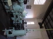
The pumping station is a brick building of plain industrial design appropriate to its use. It has an iron roof and a metal chimney. Work on construction of the pipeline under the direction of the Engineer-In-Chief, C Y O'Connor began in 1898 but this, the last of the steam pumping stations, was built at the end of 1901. It continued in use until 1970 when superseded by diesel powered plant. It is currently being restored by the trust in co-operation with the Public Works Department.
| Library Id | Title | Medium | Year Of Publication |
|---|---|---|---|
| 3873 | Goldfields Water Supply, Dedari Conservation Works Final Report-Heritage Grants Program 1997/98 | Heritage Study {Other} | 1999 |
| 7358 | Conservation plan for Goldfields Water Supply Scheme. Volume II, place M : No. 8 Pumping Station, Dedari. | Heritage Study {Cons'n Plan} | 1999 |
| 1125 | Goldfields Water Supply No. 8 Steam Pumping Station at Dedari. | Heritage Study {Cons'n Plan} | 1995 |
Individual Building or Group
| Epoch | General | Specific |
|---|---|---|
| Present Use | EDUCATIONAL | Museum |
| Original Use | GOVERNMENTAL | Pumping Station |
| Style |
|---|
| Federation Warehouse |
| Type | General | Specific |
|---|---|---|
| Roof | METAL | Corrugated Iron |
| Wall | BRICK | Common Brick |
| General | Specific |
|---|---|
| OCCUPATIONS | Technology & technological change |
This information is provided voluntarily as a public service. The information provided is made available in good faith and is derived from sources believed to be reliable and accurate. However, the information is provided solely on the basis that readers will be responsible for making their own assessment of the matters discussed herein and are advised to verify all relevant representations, statements and information.
Constructed from 1901
Significant as one of 8 former steam pumping stations in the 1898-1901 Mundaring-Kalgoorlie Water Pipeline, an important engineering feat, of major importance in the opening up of the eastern goldfields and the wheatbelt and contributing to the major development of the state. Of technological significance as the best preserved, in engineering terms, of these stations with virtually complete machinery and boilers in authentic working condition.
The pumping station is a brick building of plain industrial design appropriate to its use. It has an iron roof and a metal chimney. Work on the construction of the pipeline under the direction of engineer-in-chief, C.Y. O'Connor began in 1898 but this, the last of the steam pumping stations, was built at the end of 1901. It continued in use until 1970 when it was superseded by a diesel powered plant. It was restored by the National Trust in co-operation with the P.W.D. The interior is virtually intact.
Mundaring-Kalgoorlie Water Pipeline Structure with 2 Babcock and Wilcox boilers; four James Simpson pumps and an Asco weighbridge all intact, demonstrating the nature and function of the place. Strong associations with C.Y. O'Connor, the scheme's engineer and the state's most ambitious undertaking of an engineering project at the time.
High
Good
| Ref ID No | Ref Name | Ref Source | Ref Date |
|---|---|---|---|
| Webb, M&A "The Centennial History of Kalgoorlie-Boulder" | 1993 | ||
| National Trust Citation |
| Owner | Category |
|---|---|
| National Trust of Australia | Other Private |
This information is provided voluntarily as a public service. The information provided is made available in good faith and is derived from sources believed to be reliable and accurate. However, the information is provided solely on the basis that readers will be responsible for making their own assessment of the matters discussed herein and are advised to verify all relevant representations, statements and information.
Coolgardie-Esperance Hwy Widgiemooltha
Coolgardie
Goldfields
Constructed from 1896
| Type | Status | Date | Documents |
|---|---|---|---|
| (no listings) |
| Type | Status | Date | Documents |
|---|---|---|---|
| (no listings) |
| Type | Status | Date | Grading/Management | |
|---|---|---|---|---|
| Category | ||||
| Municipal Inventory | Adopted | 27 Jul 1995 | Category 4 | |
Historic Town or district
| Epoch | General | Specific |
|---|---|---|
| Original Use | MINING | Other |
| Present Use | MINING | Other |
| General | Specific |
|---|---|
| DEMOGRAPHIC SETTLEMENT & MOBILITY | Resource exploitation & depletion |
This information is provided voluntarily as a public service. The information provided is made available in good faith and is derived from sources believed to be reliable and accurate. However, the information is provided solely on the basis that readers will be responsible for making their own assessment of the matters discussed herein and are advised to verify all relevant representations, statements and information.
Constructed from 1896
An important site worth marking.
The Paris mine was on of those serviced by Widgiemooltha.
A small town developed to service the surrounding mining areas.
| Ref ID No | Ref Name | Ref Source | Ref Date |
|---|---|---|---|
| Webb, M&A "The Centennial History of Kalgoorlie-Boulder" | 1993 |
This information is provided voluntarily as a public service. The information provided is made available in good faith and is derived from sources believed to be reliable and accurate. However, the information is provided solely on the basis that readers will be responsible for making their own assessment of the matters discussed herein and are advised to verify all relevant representations, statements and information.
Great Eastern Hwy Woolgangie
Woolgangie Catchment and Dam
Coolgardie
Goldfields
Constructed from 1894
| Type | Status | Date | Documents |
|---|---|---|---|
| State Register | Registered | 07 Sep 2007 | HCWebsite.Listing+ListingDocument, HCWebsite.Listing+ListingDocument |
| Type | Status | Date | Documents |
|---|---|---|---|
| (no listings) |
| Type | Status | Date | Grading/Management | |
|---|---|---|---|---|
| Category | ||||
| (no listings) | ||||
Poor - The overall condition of the place is poor, most of the built features such as the two platelayers cottages, station masters house, railway platform, concrete foundations of outbuildings, telegraph station, reservoir, railway reservoir, site of pump, carrier race, watergates, stone weight, rock catchment area, and railway formation are in a ruinous state, most only have the foundations remaining. The catchment’s stone perimeter wall and carrier race are in a good condition and still carry water to the reservoirs.
| Library Id | Title | Medium | Year Of Publication |
|---|---|---|---|
| 6793 | Conservation plan for Woolgangie Catchment and Railway Settlement. (Draft). | Heritage Study {Cons'n Plan} | 2001 |
Historic site
| Epoch | General | Specific |
|---|---|---|
| Present Use | GOVERNMENTAL | Reservoir or Dam |
| Original Use | GOVERNMENTAL | Reservoir or Dam |
| Type | General | Specific |
|---|---|---|
| Wall | STONE | Local Stone |
| General | Specific |
|---|---|
| TRANSPORT & COMMUNICATIONS | Rail & light rail transport |
| DEMOGRAPHIC SETTLEMENT & MOBILITY | Settlements |
This information is provided voluntarily as a public service. The information provided is made available in good faith and is derived from sources believed to be reliable and accurate. However, the information is provided solely on the basis that readers will be responsible for making their own assessment of the matters discussed herein and are advised to verify all relevant representations, statements and information.
Great Eastern Hwy Yerdanie Rock
Located on Reserve 46126, near the Southern base of Yerdanie Rock.
Coolgardie
Goldfields
Constructed from 1866 to 1893
| Type | Status | Date | Documents |
|---|---|---|---|
| (no listings) |
| Type | Status | Date | Documents |
|---|---|---|---|
| (no listings) |
| Type | Status | Date | Grading/Management | |
|---|---|---|---|---|
| Category | ||||
| Wells of Explorer Charles Hunt Survey | Recorded | 01 Nov 1991 | ||
24806 Hunt's Wells Group
Other Built Type
| Epoch | General | Specific |
|---|---|---|
| Original Use | GOVERNMENTAL | Other |
| Type | General | Specific |
|---|---|---|
| Wall | STONE | Granite |
| General | Specific |
|---|---|
| DEMOGRAPHIC SETTLEMENT & MOBILITY | Exploration & surveying |
| DEMOGRAPHIC SETTLEMENT & MOBILITY | Settlements |
| SOCIAL & CIVIC ACTIVITIES | Community services & utilities |
This information is provided voluntarily as a public service. The information provided is made available in good faith and is derived from sources believed to be reliable and accurate. However, the information is provided solely on the basis that readers will be responsible for making their own assessment of the matters discussed herein and are advised to verify all relevant representations, statements and information.