Local Government
Coolgardie
Region
Goldfields
Great Eastern Hwy Coolgardie
Coolgardie
Goldfields
| Type | Status | Date | Documents |
|---|---|---|---|
| (no listings) |
| Type | Status | Date | Documents |
|---|---|---|---|
| (no listings) |
| Type | Status | Date | Grading/Management | |
|---|---|---|---|---|
| Category | ||||
| Municipal Inventory | Adopted | 27 Jul 1995 | Category 2 | |
| Register of the National Estate | Registered | 21 Mar 1978 | ||
Landscape
| Epoch | General | Specific |
|---|---|---|
| Present Use | PARK\RESERVE | Park\Reserve |
| Original Use | OTHER | Other |
| General | Specific |
|---|---|
| SOCIAL & CIVIC ACTIVITIES | Environmental awareness |
This information is provided voluntarily as a public service. The information provided is made available in good faith and is derived from sources believed to be reliable and accurate. However, the information is provided solely on the basis that readers will be responsible for making their own assessment of the matters discussed herein and are advised to verify all relevant representations, statements and information.
An important though undeveloped National Park significant for flora and fauna.
A strip of land 30,000ha, 10kms wide and 30kms long, centred on the Great Eastern Highway between Koorarawalyee & Boorabbin, with established conservation values for flora and fauna including three semi arid zone banksia species (B. audax, B. elderiana and B. lullfitzii) and nine species of agamid reptile.
A former townsite exists nearby, without any surface trace of its existence
High
Very Good
This information is provided voluntarily as a public service. The information provided is made available in good faith and is derived from sources believed to be reliable and accurate. However, the information is provided solely on the basis that readers will be responsible for making their own assessment of the matters discussed herein and are advised to verify all relevant representations, statements and information.
Great Eastern Hwy Coolgardie
Boorabbin National Park, situated on a small gully bearing south from the north-east side of Boorabbin Rock. Reserve No. 2917.
Coolgardie
Goldfields
Constructed from 1865
| Type | Status | Date | Documents |
|---|---|---|---|
| (no listings) |
| Type | Status | Date | Documents |
|---|---|---|---|
| (no listings) |
| Type | Status | Date | Grading/Management | |
|---|---|---|---|---|
| Category | ||||
| Wells of Explorer Charles Hunt Survey | Recorded | 01 Nov 1991 | ||
24806 Hunt's Wells Group
Other Built Type
| Epoch | General | Specific |
|---|---|---|
| Original Use | GOVERNMENTAL | Other |
| Type | General | Specific |
|---|---|---|
| Wall | TIMBER | Other Timber |
| Wall | STONE | Granite |
| General | Specific |
|---|---|
| DEMOGRAPHIC SETTLEMENT & MOBILITY | Aboriginal Occupation |
| DEMOGRAPHIC SETTLEMENT & MOBILITY | Settlements |
| SOCIAL & CIVIC ACTIVITIES | Community services & utilities |
| DEMOGRAPHIC SETTLEMENT & MOBILITY | Exploration & surveying |
This information is provided voluntarily as a public service. The information provided is made available in good faith and is derived from sources believed to be reliable and accurate. However, the information is provided solely on the basis that readers will be responsible for making their own assessment of the matters discussed herein and are advised to verify all relevant representations, statements and information.
Great Eastern Hwy Coolgardie
Coolgardie
Goldfields
Constructed from 1897
| Type | Status | Date | Documents |
|---|---|---|---|
| (no listings) |
| Type | Status | Date | Documents |
|---|---|---|---|
| (no listings) |
| Type | Status | Date | Grading/Management | |
|---|---|---|---|---|
| Category | ||||
| Municipal Inventory | Adopted | 27 Jul 1995 | Category 4 | |
| Library Id | Title | Medium | Year Of Publication |
|---|
Historic Site
| Epoch | General | Specific |
|---|---|---|
| Present Use | VACANT\UNUSED | Vacant\Unused |
| Original Use | FORESTRY | Other |
| Other Use | OTHER | Other |
| General | Specific |
|---|---|
| DEMOGRAPHIC SETTLEMENT & MOBILITY | Resource exploitation & depletion |
This information is provided voluntarily as a public service. The information provided is made available in good faith and is derived from sources believed to be reliable and accurate. However, the information is provided solely on the basis that readers will be responsible for making their own assessment of the matters discussed herein and are advised to verify all relevant representations, statements and information.
Constructed from 1897
An important site worth marking.
Karrawang was on one of the Kalgoorlie woodlines. The whole settlement was dismantled in 1937 and move to Lakeside. Karrawang was clear felled for timber for the mines. It later became a mission for Aboriginal people. An integral part of the goldfields story; a brief success followed by disappointment and extinction.
| Ref ID No | Ref Name | Ref Source | Ref Date |
|---|---|---|---|
| Webb, M&A "The Centennial History of Kalgoorlie-Boulder" | 1993 |
This information is provided voluntarily as a public service. The information provided is made available in good faith and is derived from sources believed to be reliable and accurate. However, the information is provided solely on the basis that readers will be responsible for making their own assessment of the matters discussed herein and are advised to verify all relevant representations, statements and information.
Great Eastern Hwy Coolgardie
Mungari
Coolgardie
Goldfields
Constructed from 1897
| Type | Status | Date | Documents |
|---|---|---|---|
| (no listings) |
| Type | Status | Date | Documents |
|---|---|---|---|
| (no listings) |
| Type | Status | Date | Grading/Management | |
|---|---|---|---|---|
| Category | ||||
| Municipal Inventory | Adopted | 27 Jul 1995 | Category 4 | |
Historic Site
| Epoch | General | Specific |
|---|---|---|
| Original Use | MINING | Other |
| Present Use | VACANT\UNUSED | Vacant\Unused |
| General | Specific |
|---|---|
| DEMOGRAPHIC SETTLEMENT & MOBILITY | Resource exploitation & depletion |
This information is provided voluntarily as a public service. The information provided is made available in good faith and is derived from sources believed to be reliable and accurate. However, the information is provided solely on the basis that readers will be responsible for making their own assessment of the matters discussed herein and are advised to verify all relevant representations, statements and information.
Constructed from 1897
An important site worth marking
An integral part of the goldfields story; brief success followed by disappointment and extinction.
An integral part of the goldfields story; brief success followed by disappointment and extinction.
| Ref ID No | Ref Name | Ref Source | Ref Date |
|---|---|---|---|
| Webb, M&A "The Centennial History of Kalgoorlie-Boulder" | 1993 |
This information is provided voluntarily as a public service. The information provided is made available in good faith and is derived from sources believed to be reliable and accurate. However, the information is provided solely on the basis that readers will be responsible for making their own assessment of the matters discussed herein and are advised to verify all relevant representations, statements and information.
Great Eastern Hwy Coolgardie
west of Coolgardie.
Coolgardie
Goldfields
Constructed from 1894
| Type | Status | Date | Documents |
|---|---|---|---|
| State Register | Registered | 20 Aug 1993 | HCWebsite.Listing+ListingDocument |
| Type | Status | Date | Documents |
|---|---|---|---|
| (no listings) |
| Type | Status | Date | Grading/Management | |
|---|---|---|---|---|
| Category | ||||
| Municipal Inventory | Adopted | 27 Jul 1995 | Category 1 | |
| Classified by the National Trust | Classified | 06 Dec 1976 | ||
| Register of the National Estate | Permanent | 21 Mar 1978 | ||
The register entry includes stone and timber headstones and cast iron railings, and the land on which they stand being Reserve 2772.
Other Built Type
| Epoch | General | Specific |
|---|---|---|
| Original Use | MONUMENT\CEMETERY | Cemetery |
| Present Use | MONUMENT\CEMETERY | Cemetery |
| General | Specific |
|---|---|
| DEMOGRAPHIC SETTLEMENT & MOBILITY | Settlements |
This information is provided voluntarily as a public service. The information provided is made available in good faith and is derived from sources believed to be reliable and accurate. However, the information is provided solely on the basis that readers will be responsible for making their own assessment of the matters discussed herein and are advised to verify all relevant representations, statements and information.
Social and historic associations with the foundation of Coolgardie
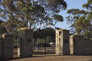
The current cemetery for the district located west of the townsite area, established in 1894 and containing the graves of many of the early people who worked to establish the town of Coolgardie
Assessment: 1976 Construction 1894
This information is provided voluntarily as a public service. The information provided is made available in good faith and is derived from sources believed to be reliable and accurate. However, the information is provided solely on the basis that readers will be responsible for making their own assessment of the matters discussed herein and are advised to verify all relevant representations, statements and information.
Constructed from 1894
The cemetery is of substantial historical and social significance, providing a link with a number of individuals who played the role in the foundation of the town.
The current cemetery for the district, located west of the townsite area, established in 1894 and containing the graves of many of the early people who worked to establish the town of Coolgardie. The register entry includes stone and timber headstones and cast iron railings, and the land on which they stand, which is reserve 2772. The site is maintained by the Shire of Coolgardie.
Coolgardie's second cemetery contains in excess of 1000 burials and many of the headstones tell of the hardship of life in the goldfields, including the famous and ordinary folk; Ernest Giles spent his last years in Coolgardie and was buried in this cemetery.
High
Varying
| Ref ID No | Ref Name | Ref Source | Ref Date |
|---|---|---|---|
| Webb, M&A "The Centennial History of Kalgoorlie-Boulder" | 1993 |
| Owner | Category |
|---|---|
| Shire of Coolgardie | Local Gov't |
This information is provided voluntarily as a public service. The information provided is made available in good faith and is derived from sources believed to be reliable and accurate. However, the information is provided solely on the basis that readers will be responsible for making their own assessment of the matters discussed herein and are advised to verify all relevant representations, statements and information.
Great Eastern Hwy Coolgardie
The dam is situated between two granite rocks on the east side of the Warngangering outcrop.
Wargangering Dam
Coolgardie
Goldfields
Constructed from 1866
| Type | Status | Date | Documents |
|---|---|---|---|
| (no listings) |
| Type | Status | Date | Documents |
|---|---|---|---|
| (no listings) |
| Type | Status | Date | Grading/Management | |
|---|---|---|---|---|
| Category | ||||
| Wells of Explorer Charles Hunt Survey | Recorded | 01 Nov 1991 | ||
24806 Hunt's Wells Group
| Name | Type | Year From | Year To |
|---|---|---|---|
| Hunt, Charles (explorer) | Architect | - | - |
Other Built Type
| Epoch | General | Specific |
|---|---|---|
| Original Use | GOVERNMENTAL | Other |
| Original Use | GOVERNMENTAL | Reservoir or Dam |
| Type | General | Specific |
|---|---|---|
| Wall | STONE | Granite |
| General | Specific |
|---|---|
| DEMOGRAPHIC SETTLEMENT & MOBILITY | Aboriginal Occupation |
| DEMOGRAPHIC SETTLEMENT & MOBILITY | Settlements |
| SOCIAL & CIVIC ACTIVITIES | Community services & utilities |
| DEMOGRAPHIC SETTLEMENT & MOBILITY | Exploration & surveying |
This information is provided voluntarily as a public service. The information provided is made available in good faith and is derived from sources believed to be reliable and accurate. However, the information is provided solely on the basis that readers will be responsible for making their own assessment of the matters discussed herein and are advised to verify all relevant representations, statements and information.
Lot 148 Great Eastern Hwy Coolgardie
Boorabbin National Park
Coolgardie
Goldfields
| Type | Status | Date | Documents |
|---|---|---|---|
| (no listings) |
| Type | Status | Date | Documents |
|---|---|---|---|
| (no listings) |
| Type | Status | Date | Grading/Management | |
|---|---|---|---|---|
| Category | ||||
| (no listings) | ||||
Historic Site
| Epoch | General | Specific |
|---|---|---|
| Original Use | GOVERNMENTAL | Other |
| Present Use | VACANT\UNUSED | Vacant\Unused |
| Type | General | Specific |
|---|---|---|
| Wall | TIMBER | Log |
This information is provided voluntarily as a public service. The information provided is made available in good faith and is derived from sources believed to be reliable and accurate. However, the information is provided solely on the basis that readers will be responsible for making their own assessment of the matters discussed herein and are advised to verify all relevant representations, statements and information.
Great Eastern Hwy, on site of Bayleys Reward Claim Reef, Fly Flat Coolgardie
2km north-east of Coolgardie.
Coolgardie
Goldfields
Constructed from 1942
| Type | Status | Date | Documents |
|---|---|---|---|
| (no listings) |
| Type | Status | Date | Documents |
|---|---|---|---|
| (no listings) |
| Type | Status | Date | Grading/Management | |
|---|---|---|---|---|
| Category | ||||
| Classified by the National Trust | Classified | 27 Oct 1976 | ||
| Register of the National Estate | Permanent | 21 Mar 1978 | ||
Obelisk stolen, Headframe demolished
Historic site
| Epoch | General | Specific |
|---|---|---|
| Present Use | MONUMENT\CEMETERY | Monument |
| Original Use | MONUMENT\CEMETERY | Monument |
This information is provided voluntarily as a public service. The information provided is made available in good faith and is derived from sources believed to be reliable and accurate. However, the information is provided solely on the basis that readers will be responsible for making their own assessment of the matters discussed herein and are advised to verify all relevant representations, statements and information.
Marks the site of the famous reef found by Bayley and erected on the 50th anniverary of the find.
Obelisk: A concrete post marking the spot where Bayley first discovered gold in Coolgardie in 17 September 1892. It was first erected in 1942 on the 50th anniversary of his find. Headframe: This was the headframe to Bayley's Reward Claim Reef. It was demolished in 1978 as it was in a dangerous condition. The four base columns and some bracing still remain (1976)
Assessment 1967, 1973 Constructed 1942 Builder: Phoenix Gold Mine and W.K. Thirloway
This information is provided voluntarily as a public service. The information provided is made available in good faith and is derived from sources believed to be reliable and accurate. However, the information is provided solely on the basis that readers will be responsible for making their own assessment of the matters discussed herein and are advised to verify all relevant representations, statements and information.
Great Eastern Hwy, on site of Bayleys Reward Claim Reef, Fly Flat Coolgardie
2km north-east of Coolgardie.
Coolgardie
Goldfields
| Type | Status | Date | Documents |
|---|---|---|---|
| (no listings) |
| Type | Status | Date | Documents |
|---|---|---|---|
| (no listings) |
| Type | Status | Date | Grading/Management | |
|---|---|---|---|---|
| Category | ||||
| (no listings) | ||||
01736 Bayley's Obelisk
Demolished 1978
Historic site
| Epoch | General | Specific |
|---|---|---|
| Original Use | MONUMENT\CEMETERY | Monument |
This information is provided voluntarily as a public service. The information provided is made available in good faith and is derived from sources believed to be reliable and accurate. However, the information is provided solely on the basis that readers will be responsible for making their own assessment of the matters discussed herein and are advised to verify all relevant representations, statements and information.
Cnr Hunt & Shaw Sts Coolgardie
N of Bayley St
Coolgardie
Goldfields
Constructed from 1897
| Type | Status | Date | Documents |
|---|---|---|---|
| State Register | Registered | 23 Mar 2010 | HCWebsite.Listing+ListingDocument, HCWebsite.Listing+ListingDocument |
| Type | Status | Date | Documents |
|---|---|---|---|
| (no listings) |
| Type | Status | Date | Grading/Management | |
|---|---|---|---|---|
| Category | ||||
| Register of the National Estate | Permanent | 21 Mar 1978 | ||
| Classified by the National Trust | Classified | 27 Oct 1976 | ||
| Municipal Inventory | Adopted | 27 Jul 1995 | Category 1 | |
Coolgardie Primary School is generally in good condition, with regular maintenance taking place.
| Name | Type | Year From | Year To |
|---|---|---|---|
| G T Poole (1897 building) | Architect | 1897 | 1897 |
| Hillson Beasley (1900 extensions) | Architect | 1900 | 1900 |
Individual Building or Group
| Epoch | General | Specific |
|---|---|---|
| Present Use | EDUCATIONAL | Primary School |
| Original Use | EDUCATIONAL | Combined School |
| Style |
|---|
| Federation Queen Anne |
| Vernacular |
| Type | General | Specific |
|---|---|---|
| Roof | METAL | Corrugated Iron |
| Wall | STONE | Local Stone |
| General | Specific |
|---|---|
| DEMOGRAPHIC SETTLEMENT & MOBILITY | Settlements |
| PEOPLE | Aboriginal people |
| SOCIAL & CIVIC ACTIVITIES | Education & science |
| OCCUPATIONS | Mining {incl. mineral processing} |
| DEMOGRAPHIC SETTLEMENT & MOBILITY | Resource exploitation & depletion |
| SOCIAL & CIVIC ACTIVITIES | Community services & utilities |
This information is provided voluntarily as a public service. The information provided is made available in good faith and is derived from sources believed to be reliable and accurate. However, the information is provided solely on the basis that readers will be responsible for making their own assessment of the matters discussed herein and are advised to verify all relevant representations, statements and information.
Constructed from 1897
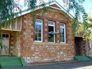
The school is of great historical significance and cultural importance, being the first permanent government school in the town and still in use. It is also of architectural significance as an example of the architecture of George Temple Poole and his adaption of school building design for the hot climate.
The school has roucg finished, random coursed stone walls with brick quoins, a corrugated iron roof and a surrounding verandah for weather protection. The building is rectangular and has seven rooms. The verandah construction has been modified and the roof is also a replacement. Windows are double hung casements with stucco lintols and sills.
This building was the first permanent school structure in the Eastern Goldfields. George Temple Poole, one of the colony's most influential architects, designed the school when he was Superintendent of the Public Works Department and Colonial Architect from 1891-1896.
High
Good
| Name | Type | Year From | Year To |
|---|---|---|---|
| G T Poole | Architect | - | - |
| Ref ID No | Ref Name | Ref Source | Ref Date |
|---|---|---|---|
| Webb, M&A "The Centennial History of Kalgoorlie-Boulder" | 1993 |
This information is provided voluntarily as a public service. The information provided is made available in good faith and is derived from sources believed to be reliable and accurate. However, the information is provided solely on the basis that readers will be responsible for making their own assessment of the matters discussed herein and are advised to verify all relevant representations, statements and information.
The original school building, still in use and good condition
A seven room school building, built of stone with a corrugated iron roof. The building is a simple style, rectangular with a verandah all round. The stonework is fairly rough and laid in a random patter. The building is well maintained andhas been recently re roofed
Assessment 1976 Architect: George Temple Poole Builder: Philp & Royal Date of construction 1897
This information is provided voluntarily as a public service. The information provided is made available in good faith and is derived from sources believed to be reliable and accurate. However, the information is provided solely on the basis that readers will be responsible for making their own assessment of the matters discussed herein and are advised to verify all relevant representations, statements and information.
Hunt St Coolgardie
Coola Garbi Gnamma Hole
Coolgardie
Goldfields
| Type | Status | Date | Documents |
|---|---|---|---|
| (no listings) |
| Type | Status | Date | Documents |
|---|---|---|---|
| (no listings) |
| Type | Status | Date | Grading/Management | |
|---|---|---|---|---|
| Category | ||||
| Municipal Inventory | Adopted | 27 Jul 1995 | Category 2 | |
Historic Site
| Epoch | General | Specific |
|---|---|---|
| Original Use | Transport\Communications | Water: Other |
| Present Use | Transport\Communications | Water: Other |
| Original Use | GOVERNMENTAL | Reservoir or Dam |
| General | Specific |
|---|---|
| PEOPLE | Aboriginal people |
This information is provided voluntarily as a public service. The information provided is made available in good faith and is derived from sources believed to be reliable and accurate. However, the information is provided solely on the basis that readers will be responsible for making their own assessment of the matters discussed herein and are advised to verify all relevant representations, statements and information.
An historically important site with Aboriginal significance.
An enlarged Gnamma hole with a role in the town water supply ; also the mark at which the town was declared by Warden Finnerty in October 30, 1892
Important in the story of Coolgardie as a source of water and the location of the ceremony to celebrate the declaration of the town.
Moderate
Good
| Ref ID No | Ref Name | Ref Source | Ref Date |
|---|---|---|---|
| Webb, M&A "The Centennial History of Kalgoorlie-Boulder" | 1993 |
| Owner | Category |
|---|---|
| National Trust of Australia | Other Private |
This information is provided voluntarily as a public service. The information provided is made available in good faith and is derived from sources believed to be reliable and accurate. However, the information is provided solely on the basis that readers will be responsible for making their own assessment of the matters discussed herein and are advised to verify all relevant representations, statements and information.
Hunt St Coolgardie
Coolgardie
Goldfields
| Type | Status | Date | Documents |
|---|---|---|---|
| (no listings) |
| Type | Status | Date | Documents |
|---|---|---|---|
| (no listings) |
| Type | Status | Date | Grading/Management | |
|---|---|---|---|---|
| Category | ||||
| Classified by the National Trust | Recorded | 27 Oct 1976 | ||
| Register of the National Estate | Destroyed | |||
Individual Building or Group
| Epoch | General | Specific |
|---|---|---|
| Original Use | COMMERCIAL | Hotel, Tavern or Inn |
| Present Use | COMMERCIAL | Hotel, Tavern or Inn |
This information is provided voluntarily as a public service. The information provided is made available in good faith and is derived from sources believed to be reliable and accurate. However, the information is provided solely on the basis that readers will be responsible for making their own assessment of the matters discussed herein and are advised to verify all relevant representations, statements and information.
This information is provided voluntarily as a public service. The information provided is made available in good faith and is derived from sources believed to be reliable and accurate. However, the information is provided solely on the basis that readers will be responsible for making their own assessment of the matters discussed herein and are advised to verify all relevant representations, statements and information.

56-60 Hunt St Coolgardie
Goldfields Water Supply Manager's House
Railway Barracks
Coolgardie
Goldfields
Constructed from 1899
| Type | Status | Date | Documents |
|---|---|---|---|
| (no listings) |
| Type | Status | Date | Documents |
|---|---|---|---|
| (no listings) |
| Type | Status | Date | Grading/Management | |
|---|---|---|---|---|
| Category | ||||
| Classified by the National Trust | Classified | 08 Nov 1976 | ||
| Register of the National Estate | Permanent | 21 Mar 1978 | ||
| Municipal Inventory | Adopted | 27 Jul 1995 | Category 2 | |
Individual Building or Group
| Epoch | General | Specific |
|---|---|---|
| Other Use | Transport\Communications | Rail: Housing or Quarters |
| Original Use | Transport\Communications | Water: Housing or Quarters |
| Present Use | RESIDENTIAL | Institutional Housing |
| Style |
|---|
| Victorian Regency |
| Type | General | Specific |
|---|---|---|
| Roof | METAL | Corrugated Iron |
| Wall | BRICK | Common Brick |
| General | Specific |
|---|---|
| TRANSPORT & COMMUNICATIONS | Rail & light rail transport |
This information is provided voluntarily as a public service. The information provided is made available in good faith and is derived from sources believed to be reliable and accurate. However, the information is provided solely on the basis that readers will be responsible for making their own assessment of the matters discussed herein and are advised to verify all relevant representations, statements and information.
Constructed from 1899
An integral part of this important complex of railway buildings that were vital to the development and history of the Eastern Goldfields.
Originally the Goldfields Water Supply manager's house it became part of the railway establishment. A representative architectural form for a large residential building from the turn of the century. It has panelled doors, double hung sash windows and a simply detailed verandah which is now missing some elements.
The house began life as the house for the Manager of the Goldfields Water Supply and later became a part of the railway building complex which was a vital communications and transport link for this isolated town. This building accommodated the lower ranked railway workers. In 1968 it was taken over by the YHA.
High
Good
| Ref ID No | Ref Name | Ref Source | Ref Date |
|---|---|---|---|
| Webb, M&A "The Centennial History of Kalgoorlie-Boulder" | 1993 |
| Owner | Category |
|---|---|
| Youth Hostel Association of WA Inc. | Other Private |
This information is provided voluntarily as a public service. The information provided is made available in good faith and is derived from sources believed to be reliable and accurate. However, the information is provided solely on the basis that readers will be responsible for making their own assessment of the matters discussed herein and are advised to verify all relevant representations, statements and information.
Part of the railway establishment in Coolgardie. A representative architectural form for a large residential building demonstrating the comparative changes in detail, to joinery & chimneys for example and to proportions by the turn of the century.
A large brick house with corrugated iron roof and verandahs all round. There are two large bay windows either side of the front door, and most rooms have french doors onto the verandahs. There is a kitchen wing at the back of the hosue with a verandah on the north side only. The house was originally built for the inspector of Railways, and was later converted to serve as a railway barracks.
Assessment 1976 Construction 1899
This information is provided voluntarily as a public service. The information provided is made available in good faith and is derived from sources believed to be reliable and accurate. However, the information is provided solely on the basis that readers will be responsible for making their own assessment of the matters discussed herein and are advised to verify all relevant representations, statements and information.
Jaurdi Hills Rd Coolgardie
Coolgardie
Goldfields
Constructed from 1894
| Type | Status | Date | Documents |
|---|---|---|---|
| (no listings) |
| Type | Status | Date | Documents |
|---|---|---|---|
| (no listings) |
| Type | Status | Date | Grading/Management | |
|---|---|---|---|---|
| Category | ||||
| Municipal Inventory | Adopted | 27 Jul 1995 | Category 4 | |
Historic Site
| Epoch | General | Specific |
|---|---|---|
| Original Use | VACANT\UNUSED | Vacant\Unused |
| Original Use | RESIDENTIAL | Other |
| General | Specific |
|---|---|
| DEMOGRAPHIC SETTLEMENT & MOBILITY | Resource exploitation & depletion |
This information is provided voluntarily as a public service. The information provided is made available in good faith and is derived from sources believed to be reliable and accurate. However, the information is provided solely on the basis that readers will be responsible for making their own assessment of the matters discussed herein and are advised to verify all relevant representations, statements and information.
Constructed from 1894
An important site worth marking
This was the site of the Wealth of Nations mine; another apparently rich discovery that was floated in London and vastly over subscribed. It turned out to be a poor find. An integral part of the goldfields story; a brief success followed by disappointment and extinction.
| Ref ID No | Ref Name | Ref Source | Ref Date |
|---|---|---|---|
| Webb, M&A "The Centennial History of Kalgoorlie-Boulder" | 1993 |
This information is provided voluntarily as a public service. The information provided is made available in good faith and is derived from sources believed to be reliable and accurate. However, the information is provided solely on the basis that readers will be responsible for making their own assessment of the matters discussed herein and are advised to verify all relevant representations, statements and information.
10 Jenkin St Coolgardie
Coolgardie
Goldfields
Constructed from 1900
| Type | Status | Date | Documents |
|---|---|---|---|
| (no listings) |
| Type | Status | Date | Documents |
|---|---|---|---|
| (no listings) |
| Type | Status | Date | Grading/Management | |
|---|---|---|---|---|
| Category | ||||
| Municipal Inventory | Adopted | 27 Jul 1995 | Category 3 | |
Individual Building or Group
| Epoch | General | Specific |
|---|---|---|
| Original Use | RESIDENTIAL | Single storey residence |
| Present Use | RESIDENTIAL | Single storey residence |
| Type | General | Specific |
|---|---|---|
| Wall | BRICK | Painted Brick |
| Roof | METAL | Corrugated Iron |
| General | Specific |
|---|---|
| DEMOGRAPHIC SETTLEMENT & MOBILITY | Settlements |
This information is provided voluntarily as a public service. The information provided is made available in good faith and is derived from sources believed to be reliable and accurate. However, the information is provided solely on the basis that readers will be responsible for making their own assessment of the matters discussed herein and are advised to verify all relevant representations, statements and information.
Constructed from 1900
A remnant of Montana with some fine mature trees in the garden.
A modest brick construction house with a steeply pitched roof and a gable addressing the street, with double hung sash windows and a panelled front door. Much of the detailing on the verandah has been lost and the painting of the walls obscures their original beauty.
One of a small number of brick construction houses to survive in the suburb of Montana.
Low-Moderate
Good
| Owner | Category |
|---|---|
| W Reed and M McCallum | Other Private |
This information is provided voluntarily as a public service. The information provided is made available in good faith and is derived from sources believed to be reliable and accurate. However, the information is provided solely on the basis that readers will be responsible for making their own assessment of the matters discussed herein and are advised to verify all relevant representations, statements and information.
5 Jenkin St Coolgardie
Coolgardie
Goldfields
Constructed from 1900
| Type | Status | Date | Documents |
|---|---|---|---|
| (no listings) |
| Type | Status | Date | Documents |
|---|---|---|---|
| (no listings) |
| Type | Status | Date | Grading/Management | |
|---|---|---|---|---|
| Category | ||||
| Municipal Inventory | Adopted | 27 Jul 1995 | Category 2 | |
Individual Building or Group
| Epoch | General | Specific |
|---|---|---|
| Original Use | INDUSTRIAL\MANUFACTURING | Bakery |
| Present Use | COMMERCIAL | Warehouse |
| Type | General | Specific |
|---|---|---|
| Wall | METAL | Corrugated Iron |
| Roof | METAL | Corrugated Iron |
| General | Specific |
|---|---|
| OCCUPATIONS | Manufacturing & processing |
This information is provided voluntarily as a public service. The information provided is made available in good faith and is derived from sources believed to be reliable and accurate. However, the information is provided solely on the basis that readers will be responsible for making their own assessment of the matters discussed herein and are advised to verify all relevant representations, statements and information.
Constructed from 1900
Important as a rare example of industrial structures remaining intact.
A large volume space the equivalent of 1.5 storeys with a high pitched gable roof over the main space and a catslide leanto roof to the east. It was constructed for the purpose of baking. It has a loft door to the southern gable and brick construction ovens and flue to the north gabled end of the building.
One of the very few surviving industrial buildings to remain in Coolgardie.
High
Poor
| Owner | Category |
|---|---|
| M&J Charlton | Other Private |
This information is provided voluntarily as a public service. The information provided is made available in good faith and is derived from sources believed to be reliable and accurate. However, the information is provided solely on the basis that readers will be responsible for making their own assessment of the matters discussed herein and are advised to verify all relevant representations, statements and information.
Karramindie Coolgardie
Reserve No. 2956
Coolgardie
Goldfields
Constructed from 1866
| Type | Status | Date | Documents |
|---|---|---|---|
| (no listings) |
| Type | Status | Date | Documents |
|---|---|---|---|
| (no listings) |
| Type | Status | Date | Grading/Management | |
|---|---|---|---|---|
| Category | ||||
| (no listings) | ||||
24806 Hunt's Wells Group
Other Built Type
| Epoch | General | Specific |
|---|---|---|
| Original Use | GOVERNMENTAL | Other |
| Type | General | Specific |
|---|---|---|
| Wall | STONE | Granite |
| General | Specific |
|---|---|
| SOCIAL & CIVIC ACTIVITIES | Community services & utilities |
| DEMOGRAPHIC SETTLEMENT & MOBILITY | Exploration & surveying |
| DEMOGRAPHIC SETTLEMENT & MOBILITY | Aboriginal Occupation |
| DEMOGRAPHIC SETTLEMENT & MOBILITY | Settlements |
This information is provided voluntarily as a public service. The information provided is made available in good faith and is derived from sources believed to be reliable and accurate. However, the information is provided solely on the basis that readers will be responsible for making their own assessment of the matters discussed herein and are advised to verify all relevant representations, statements and information.
58 King St Coolgardie
Coolgardie
Goldfields
Constructed from 1900
| Type | Status | Date | Documents |
|---|---|---|---|
| (no listings) |
| Type | Status | Date | Documents |
|---|---|---|---|
| (no listings) |
| Type | Status | Date | Grading/Management | |
|---|---|---|---|---|
| Category | ||||
| Municipal Inventory | Adopted | 27 Jul 1995 | Category 5 | |
Individual Building or Group
| Epoch | General | Specific |
|---|---|---|
| Present Use | VACANT\UNUSED | Vacant\Unused |
| Original Use | RESIDENTIAL | Single storey residence |
| General | Specific |
|---|---|
| DEMOGRAPHIC SETTLEMENT & MOBILITY | Settlements |
This information is provided voluntarily as a public service. The information provided is made available in good faith and is derived from sources believed to be reliable and accurate. However, the information is provided solely on the basis that readers will be responsible for making their own assessment of the matters discussed herein and are advised to verify all relevant representations, statements and information.
Constructed from 1900
A good example of the goldfields type of dwelling, though in a poor state of repair.
A good example of an earlier framed dwelling.
A good example of early suburban framed dwelling that grew by a series of accretions.
Moderate
Good
| Owner | Category |
|---|---|
| Blackrange Holdings | Other Private |
This information is provided voluntarily as a public service. The information provided is made available in good faith and is derived from sources believed to be reliable and accurate. However, the information is provided solely on the basis that readers will be responsible for making their own assessment of the matters discussed herein and are advised to verify all relevant representations, statements and information.
79 King St Coolgardie
Coolgardie
Goldfields
Constructed from 1890
| Type | Status | Date | Documents |
|---|---|---|---|
| (no listings) |
| Type | Status | Date | Documents |
|---|---|---|---|
| (no listings) |
| Type | Status | Date | Grading/Management | |
|---|---|---|---|---|
| Category | ||||
| Register of the National Estate | Permanent | 21 Mar 1978 | ||
| Register of the National Estate | Removed from RNE | |||
| Classified by the National Trust | Classified | 27 Oct 1978 | ||
Individual Building or Group
| Epoch | General | Specific |
|---|---|---|
| Original Use | RESIDENTIAL | Single storey residence |
| Present Use | RESIDENTIAL | Single storey residence |
This information is provided voluntarily as a public service. The information provided is made available in good faith and is derived from sources believed to be reliable and accurate. However, the information is provided solely on the basis that readers will be responsible for making their own assessment of the matters discussed herein and are advised to verify all relevant representations, statements and information.

71-73 Lindsay St Coolgardie
To be assessed with P573 St Anthony’s Convent of Mercy (fmr)
Coolgardie
Goldfields
Constructed from 1902
| Type | Status | Date | Documents |
|---|---|---|---|
| (no listings) |
| Type | Status | Date | Documents |
|---|---|---|---|
| RHP - Assessed - Consultation (Preliminary) | Current | 13 Jun 2003 |
| Type | Status | Date | Grading/Management | |
|---|---|---|---|---|
| Category | ||||
| Register of the National Estate | Permanent | 21 Mar 1978 | ||
| Classified by the National Trust | Classified | 06 Dec 1976 | ||
| Catholic Church Inventory | Completed | 01 Jul 1998 | ||
| Municipal Inventory | Adopted | 27 Jul 1995 | Category 1 | |
• The place is a good example of a substantial red brick church building in the Federation Gothic style.
• The place is a landmark due to its size and form and location on the corner of Lindsay and Lefroy Streets and as such makes a significant contribution to the Coolgardie townscape.
• The place is associated with the discovery of gold in the region in 1892 and the subsequent development of the Coolgardie townsite in the 1890s.
• The place has associations with prominent architectural firm Cavanagh and Cavanagh.
• The place has social value for its religious, education and social associations since 1902.
The place is a double volume red brick building with gable frontage and a gable vented CGI roof. The front porch is located centrally in the façade and is also gable in form with a separate roof. The building is cruciform in plan. The building has horizontal rendered bands and reveals. There is a facetted bay to the rear.
In 1892, gold was discovered near Coolgardie by Bayley and Ford and the field was declared in that same year. This was followed by mass migration to this area by people eager to strike a claim of their own. The discovery of gold and the burgeoning town at Coolgardie signalled the further exploration and settlement of the remainder of what became known as the Eastern Goldfields area, and the town of Coolgardie developed as the mining, business and administrative centre of the Eastern Goldfields. The original church on the property was a timber framed and iron clad church dating from 1892. This was demolished to make way for the permanent brick building, for which the foundation stone was laid in 1902. The 1902 church was designed by well-known architectural firm Cavanagh and Cavanagh, who were responsible for the design of many buildings for the Roman Catholic Church around the state. J. Millington was awarded the building tender.
High
Good
| Name | Type | Year From | Year To |
|---|---|---|---|
| ME & JC Cavanagh | Architect | - | - |
| Library Id | Title | Medium | Year Of Publication |
|---|---|---|---|
| 9881 | St Mary's Roman Catholic Church Coolgardie DRAFT | Heritage Study {Cons'n Plan} | 2011 |
Individual Building or Group
| Epoch | General | Specific |
|---|---|---|
| Present Use | RELIGIOUS | Church, Cathedral or Chapel |
| Original Use | RELIGIOUS | Church, Cathedral or Chapel |
| Style |
|---|
| Federation Gothic |
| Type | General | Specific |
|---|---|---|
| Roof | METAL | Corrugated Iron |
| Wall | BRICK | Other Brick |
| General | Specific |
|---|---|
| SOCIAL & CIVIC ACTIVITIES | Religion |
This information is provided voluntarily as a public service. The information provided is made available in good faith and is derived from sources believed to be reliable and accurate. However, the information is provided solely on the basis that readers will be responsible for making their own assessment of the matters discussed herein and are advised to verify all relevant representations, statements and information.
Constructed from 1902
A well maintained complete building representative of church buildings of the turn of the century. Connected with the early history of the State and the era's most influential catholic architects.
This building replaced and earlier timber framed, iron clad, unlined church from 1892. The current building was constructed in 1902. Designed in the gothic style typical for churches of all denominations at this time, it is a well built brick building with a simple auditory plan and a polygonal chancel, stucco dressings and corrugated iron roof. It is still in use.
The most substantial ecclesiastical building constructed at the height of Coolgardie's prosperity. Designed by Michael Cavanagh, a prominent Perth architect who practiced from 1895-1935. He designed many of the Catholic Church's buildings in W.A. at this time as well as many commercial, civic and residential buildings.
High
Good
| Ref ID No | Ref Name | Ref Source | Ref Date |
|---|---|---|---|
| Webb, M&A "The Centennial History of Kalgoorlie-Boulder" | 1993 |
| Owner | Category |
|---|---|
| Roman Catholic Archbishop of Perth | Church Property |
This information is provided voluntarily as a public service. The information provided is made available in good faith and is derived from sources believed to be reliable and accurate. However, the information is provided solely on the basis that readers will be responsible for making their own assessment of the matters discussed herein and are advised to verify all relevant representations, statements and information.