Local Government
Bunbury
Region
South West
6 Mansfield St Bunbury
Bunbury
South West
Constructed from 1925 to 1970
| Type | Status | Date | Documents |
|---|---|---|---|
| (no listings) |
| Type | Status | Date | Documents |
|---|---|---|---|
| (no listings) |
| Type | Status | Date | Grading/Management | |
|---|---|---|---|---|
| Category | ||||
| Municipal Inventory | Adopted | 04 Sep 2001 | ||
| Classified by the National Trust | Recorded | 04 May 1981 | ||
| Register of the National Estate | Destroyed | |||
| Municipal Inventory | Adopted | 31 Jul 1996 | Historic Site | |
Individual Building or Group
| Epoch | General | Specific |
|---|---|---|
| Original Use | RESIDENTIAL | Single storey residence |
| Present Use | VACANT\UNUSED | Vacant\Unused |
| Type | General | Specific |
|---|---|---|
| Roof | METAL | Corrugated Iron |
| Wall | TIMBER | Other Timber |
This information is provided voluntarily as a public service. The information provided is made available in good faith and is derived from sources believed to be reliable and accurate. However, the information is provided solely on the basis that readers will be responsible for making their own assessment of the matters discussed herein and are advised to verify all relevant representations, statements and information.
Constructed from 1925, Constructed from 1940
DEMOLISHED The house was relocated from Elgin as part of a privately sponsored emigration scheme in the post World War II period. Mr Vickery brought out families from England and housed them in buildings relocated from elsewhere in the South West. .
DEMOLISHED Was a small timber and iron cottage with brick chimney which was typical of the vernacular worker's cottage form. The building was moved from Capel in 1960s and suffered collapse and reconstruction in the 1970s. It was demolished in 1998.
The house was first constructed as a Group Settlement cottage at Elgin, near Capel in the 1920s. It was relocated to Mansfield Street in the 1960s, when F Vickery bought a small farm there. It may have been connected with a post-World War II scheme in which Mr Vickery bought out and settled many English migrants in and around Bunbury. Mansfield Street was named by Vickery in remembrance of his wife’s hometown of Mansfield, England. The timber and iron cottage collapsed and was substantially rebuilt in the 1970s. it was demolished in 1998.
DEMOLISHED
No visible remains.
| Reserve | Lot/Location | Plan/Diagram | Vol/Folio |
|---|---|---|---|
| 32 | D019190 32 | VOL1727FOL516 |
This information is provided voluntarily as a public service. The information provided is made available in good faith and is derived from sources believed to be reliable and accurate. However, the information is provided solely on the basis that readers will be responsible for making their own assessment of the matters discussed herein and are advised to verify all relevant representations, statements and information.
8 Mansfield St Bunbury
Bunbury
South West
Constructed from 1920
| Type | Status | Date | Documents |
|---|---|---|---|
| (no listings) |
| Type | Status | Date | Documents |
|---|---|---|---|
| (no listings) |
| Type | Status | Date | Grading/Management | |
|---|---|---|---|---|
| Category | ||||
| Municipal Inventory | Adopted | 04 Sep 2001 | ||
| Classified by the National Trust | Recorded | 04 May 1981 | ||
| Municipal Inventory | Adopted | 31 Jul 1996 | Historic Site | |
Individual Building or Group
| Epoch | General | Specific |
|---|---|---|
| Original Use | RESIDENTIAL | Single storey residence |
| Present Use | VACANT\UNUSED | Vacant\Unused |
| Style |
|---|
| Federation Bungalow |
| Type | General | Specific |
|---|---|---|
| Wall | BRICK | Common Brick |
| Roof | METAL | Corrugated Iron |
This information is provided voluntarily as a public service. The information provided is made available in good faith and is derived from sources believed to be reliable and accurate. However, the information is provided solely on the basis that readers will be responsible for making their own assessment of the matters discussed herein and are advised to verify all relevant representations, statements and information.
DEMOLISHED The house was relocated from Elgin to become the Vickery family home. In the post-World War II period, Vickery sponsored a private emigration scheme, bringing out families from England. He housed them in relocated houses near his own.
DEMOLISHED
It is believed that the house was first constructed as a Group Settlement cottage at Elgin, near Capel in the 1920s. It was relocated to Mansfield Street in the 1960s, when F Vickery bought a small farm there. It became the Vickery family home. Mr Vickery operated a private scheme in the post-World War II period in which he bought out and settled many English migrants in and around Bunbury. Mansfield Street was named by Vickery in remembrance of his wife’s hometown of Mansfield, England. The house was demolished in 1998. A block of flats was built on the site.
DEMOLISHED for redevelopment with a block of units.
No visible remains except for one large palm tree on the site.
| Reserve | Lot/Location | Plan/Diagram | Vol/Folio |
|---|---|---|---|
| S012319 | VOL1677FOL661 |
This information is provided voluntarily as a public service. The information provided is made available in good faith and is derived from sources believed to be reliable and accurate. However, the information is provided solely on the basis that readers will be responsible for making their own assessment of the matters discussed herein and are advised to verify all relevant representations, statements and information.
Marlston Dv Bunbury
fmr Ocean Drive - north. Opposite Lighthouse Resort & overlooks Indian Ocean
Bunbury
South West
Constructed from 1971
| Type | Status | Date | Documents |
|---|---|---|---|
| (no listings) |
| Type | Status | Date | Documents |
|---|---|---|---|
| (no listings) |
| Type | Status | Date | Grading/Management | |
|---|---|---|---|---|
| Category | ||||
| Municipal Inventory | Adopted | 31 Jul 1996 | Considerable Signifiance | |
Historic site
| Epoch | General | Specific |
|---|---|---|
| Present Use | RESIDENTIAL | Other |
| Original Use | Transport\Communications | Water: Lighthouse |
| Type | General | Specific |
|---|---|---|
| Wall | METAL | Steel |
| Other | GLASS | Glass |
| General | Specific |
|---|---|
| TRANSPORT & COMMUNICATIONS | River & sea transport |
This information is provided voluntarily as a public service. The information provided is made available in good faith and is derived from sources believed to be reliable and accurate. However, the information is provided solely on the basis that readers will be responsible for making their own assessment of the matters discussed herein and are advised to verify all relevant representations, statements and information.
Constructed from 1971
Checkered Lighthouse has cultural heritage significance for the following reasons: It is a promient landmark easily seen from Bunbury and the ocean; It marks the site of preceding lighthouses in Bunbury, which have guided ships into Bunbury Harbour since the 1830s.
The Lighthouse is a bold black and white checkerboard painted steel lighthouse tower in the functionalist tradition, with automatic light operation. Located in the Marlston Hill precinct the lighthouse is highly visible from many points in Bunbury and provides a strong landmark for the town.
The first navigational aid used in Bunbury was a wooden keg with a storm lantern. It was located on this site. Marlston Hill (See B001.1 & B001.2) has been known by several different names over the last century. The Aboriginal name for it is Bulligup/Bullyup and in 1841 it was known as Flagstaff Hill. There is also reference in an 1841 hydrographic survey of Koombana Bay and environs by John Lort Stokes of the “Beagle” of the feature being called Signal Hill. The name Marlston Hill appears on cadastral maps as early as June 1849 and is thought to be given by Surveyor S. J Roe, after the Marlston House Hermitage in Newbury in Berkshire, England (owned by a family named Bunbury). Roe was born in 1797 near Newbury, where his father was the local rector. Marlston Hill is the highest part of the harbour area and was used as a trigg point for the original town survey in 1841. A lighthouse was built on top of the hill c 1870. It was replaced in 1901 and relocated to another position on Marlston Drive in 1971. (See B001.2 and B112) Marlston Hill was also industrial area and then in 1988, the Rotary Club built Lookout Tower on top of the hill with funds from the community and Bicentennial grants. The Rotary Tower is used a popular lookout and hosts telecommunications equipment. In 1996 an urban renewal program began on Marston Hill which aimed at rezoning of land and removing of any sign of industry. This resulted in the rapid growth of the area with housing and commercial premises, as well as the establishment of Jetty Park. Jetty Park recognizes the maritime heritage of the area with a nautical theme and uses timber from the old Bunbury timber jetty for bollards and tree guards. Walkways link the area with the CBD. The Marlston Hill Redevelopment Project was officially opened by the Minister for Lands, Doug Shave, in February 1998. The aim of the project was to create a seamless flow of development between the city and the water. The project won the Urban Development Institute of Australia’s National Award for Urban Renewal in 2000. The place now provides business, recreational and lifestyle opportunities.
High degree of integrity (original intent clear, current use compatible, high long term sustainability). High degree of authenticity with much original fabric remaining. (These statements based on street survey only).
Condition assessed as good (assessed from streetscape survey only).
This information is provided voluntarily as a public service. The information provided is made available in good faith and is derived from sources believed to be reliable and accurate. However, the information is provided solely on the basis that readers will be responsible for making their own assessment of the matters discussed herein and are advised to verify all relevant representations, statements and information.
Marlston Hill Bunbury
High sand dune overlooking Koombana Bay
Flagstaff Hill, Bulligup or Bullyup,
Lighthouse Hill, Signal Hill
Bunbury
South West
Constructed from 1996 to 2000
| Type | Status | Date | Documents |
|---|---|---|---|
| (no listings) |
| Type | Status | Date | Documents |
|---|---|---|---|
| (no listings) |
| Type | Status | Date | Grading/Management | |
|---|---|---|---|---|
| Category | ||||
| Municipal Inventory | Adopted | 31 Jul 1996 | DELETE THIS ENTRY - COMBINED WITH ENTRY | |
| Library Id | Title | Medium | Year Of Publication |
|---|---|---|---|
| 7305 | Marlston Hill and all that. | Book | 2001 |
Historic Site
| Epoch | General | Specific |
|---|---|---|
| Original Use | Transport\Communications | Water: Other |
| Present Use | RESIDENTIAL | Other |
| Original Use | Transport\Communications | Water: Lighthouse |
| Style |
|---|
| Other Style |
| Type | General | Specific |
|---|---|---|
| Wall | TIMBER | Other Timber |
| Wall | BRICK | Common Brick |
| Wall | CONCRETE | Concrete Block |
| Roof | METAL | Other Metal |
| General | Specific |
|---|---|
| TRANSPORT & COMMUNICATIONS | River & sea transport |
This information is provided voluntarily as a public service. The information provided is made available in good faith and is derived from sources believed to be reliable and accurate. However, the information is provided solely on the basis that readers will be responsible for making their own assessment of the matters discussed herein and are advised to verify all relevant representations, statements and information.
Constructed from 1996
DELETE THIS ENTRY - COMBINED WITH ENTRY NO. 001.
DELETE THIS ENTRY - COMBINED WITH ENTRY NO. 090. Marlston Hill is a natural feature consisting of a high sand dune overlooking Koombana Bay and the Indian Ocean. This elevated site has been used for many purposes e.g. lookout point; site of previous lighthouses; place for industrial fuel storage tanks; and is currently a showcase precinct for mixed-use high density residential and commercial use. Many photographs of Bunbury down through the years can be linked to shots taken from Marlston Hill looking south or east, providing a unique set of documents for comparative analysis.
Marlston Hill has been known by several different names over the last century. The Aboriginal name for it is Bulligup/Bullyup and in 1841 it was known as Flagstaff Hill. There is also reference in an 1841 hydrographic survey of Koombana Bay and environs by John Lort Stokes of the “Beagle” of the feature being called Signal Hill. The name Marlston Hill appears on cadastral maps as early as June 1849 and is thought to be named by Surveyor S. J Roe, after the Marlston House Hermitage in Newbury in Berkshire, England. Roe was born in 1797 near Newbury, where his father was the local rector. Marlston Hill is the highest part of the harbour area and was used as a Trigg point for the original survey of the town of Bunbury in 1841 by H. M. Ommanney. It is possible that the American whaling fleet used the hill as a landmark when they wanted to enter Koombana Bay to trade with the local residents. A lighthouse was built on Marlston Hill c. 1870 to guide ships into Point Leschenault and, later, into Bunbury Harbour. The original lighthouse was built of timber with a store room below to house flags. In 1901, this was replaced by steel skeleton tower which used a gasoline/kerosene powered light. The light was converted to electricity in 1905. The lighthouse was relocated to its present location on Marlston Drive in 1971. (See B112.) Marlston Hill was also used as an industrial area. In 1960 BP built bulk fuel tanks on the hill which resulted in the height of the lighthouse being raised by twenty feet so that ships out at see could see the light over the top of the tanks. The Rotary Lookout Tower was built in 1988 with funds from local community donations and funding from Bicentennial grants. An initiative of the Bunbury Rotary Club, the lookout tower opened on 11 June 1988. The Rotary Tower is used as a lookout and as a host to telecommunications equipment. From the tower it is possible to see the city of Bunbury through to Eaton and Australind, the ocean, Koombana Bay and towards Roelands Hills and the hinterland. In 1996 an urban renewal program began on Marston Hill which resulted in the rezoning of land and the removal of any sign of industry. This resulted in the rapid growth of the area with housing and commercial premises, as well as the establishment of Jetty Park. Jetty Park recognizes the maritime heritage of the area with a nautical theme and uses timber from the old Bunbury timber jetty for bollards and tree guards. Well constructed walkways link the area with the CBD. The Marlston Hill Redevelopment Project was officially opened by the Minister for Lands, Doug Shave,m in February 1998. The aim of the project was to create a seamless flow of development between the city and the water. The project one the Urban Development Institute of Australia’s National Award for Urban Renewal in 2000. The place now provides business, recreational and lifestyle opportunities.
DELETE THIS ENTRY - COMBINED WITH ENTRY NO. 001.
This information is provided voluntarily as a public service. The information provided is made available in good faith and is derived from sources believed to be reliable and accurate. However, the information is provided solely on the basis that readers will be responsible for making their own assessment of the matters discussed herein and are advised to verify all relevant representations, statements and information.
27 Marmion St Bunbury
Lynvale
Bunbury
South West
Constructed from 1880 to 1890
| Type | Status | Date | Documents |
|---|---|---|---|
| (no listings) |
| Type | Status | Date | Documents |
|---|---|---|---|
| (no listings) |
| Type | Status | Date | Grading/Management | |
|---|---|---|---|---|
| Category | ||||
| Municipal Inventory | Adopted | 31 Jul 1996 | Historic Site | |
Individual Building or Group
| Epoch | General | Specific |
|---|---|---|
| Original Use | FARMING\PASTORAL | Cottage |
| Present Use | VACANT\UNUSED | Vacant\Unused |
| Style |
|---|
| Victorian Colonial |
| Type | General | Specific |
|---|---|---|
| Roof | METAL | Corrugated Iron |
| Wall | TIMBER | Weatherboard |
This information is provided voluntarily as a public service. The information provided is made available in good faith and is derived from sources believed to be reliable and accurate. However, the information is provided solely on the basis that readers will be responsible for making their own assessment of the matters discussed herein and are advised to verify all relevant representations, statements and information.
Constructed from 1890, Constructed from 1880
DEMOLISHED Lewin, 27 Marmion Street was a good example of residential housing in the early development of Bunbury.
DEMOLISHED
‘Lewin’ was a farmhouse built on the rural fringe of the townsite of Bunbury in the 1880s. As the town expanded, the farm was subdivided and the house gradually became part of the city environs. The house was a simple timber and iron building typical of worker’s cottages, with an external brick fireplace. The house was also called Lynvale at some stage. It was demolished c 1980.
DEMOLISHED
DEMOLISHED
| Reserve | Lot/Location | Plan/Diagram | Vol/Folio |
|---|---|---|---|
| 56 | P015107 56 |
This information is provided voluntarily as a public service. The information provided is made available in good faith and is derived from sources believed to be reliable and accurate. However, the information is provided solely on the basis that readers will be responsible for making their own assessment of the matters discussed herein and are advised to verify all relevant representations, statements and information.
Cnr Milligan St & Hands Av Bunbury
Bunbury
South West
Constructed from 1906
| Type | Status | Date | Documents |
|---|---|---|---|
| Heritage List | Adopted | 15 Apr 2003 |
| Type | Status | Date | Documents |
|---|---|---|---|
| (no listings) |
| Type | Status | Date | Grading/Management | |
|---|---|---|---|---|
| Category | ||||
| Municipal Inventory | Adopted | 04 Sep 2001 | ||
| Municipal Inventory | Adopted | 31 Jul 1996 | Historic Site | |
Urban Park
| Epoch | General | Specific |
|---|---|---|
| Other Use | RESIDENTIAL | Other |
| Present Use | PARK\RESERVE | Park\Reserve |
| Original Use | PARK\RESERVE | Park\Reserve |
| General | Specific |
|---|---|
| OUTSIDE INFLUENCES | Water, power, major t'port routes |
| PEOPLE | Aboriginal people |
| OCCUPATIONS | Domestic activities |
| DEMOGRAPHIC SETTLEMENT & MOBILITY | Aboriginal Occupation |
| SOCIAL & CIVIC ACTIVITIES | Law & order |
| DEMOGRAPHIC SETTLEMENT & MOBILITY | Racial contact & interaction |
| SOCIAL & CIVIC ACTIVITIES | Government & politics |
This information is provided voluntarily as a public service. The information provided is made available in good faith and is derived from sources believed to be reliable and accurate. However, the information is provided solely on the basis that readers will be responsible for making their own assessment of the matters discussed herein and are advised to verify all relevant representations, statements and information.
Constructed from 1906
HISTORIC SITE At the turn of the century, inter-racial relations between Aboriginals and settlers were led by a prevailing attitude throughout Australia of a general conviction of the cultural superiority of white Anglo-Saxons. While this was not often expressed malevolently by Europeans, it did reinforce discrimination of a sector of the community who were deemed outsiders and marginalised. The place represents the state of interacial relations at a local level during this period.
Large open recreation space now located near Donaldson Park Trotting Complex.
PIn 1905, legislation was enacted to appoint a Chief Inspector of Aborigines ‘for their own good’. In 1906, the Bunbury authorities interpreted this as a mandate for them to move the camp near Wilkes’s Crossing (where police had recently reported that the people of Bunbury were hostile to the Aboriginal people camped there) to a large, 40 acre commonage at the rear of the race course. The new camp was well removed from the main road and urban populations at the time. What were effectively segregationist policies were enforced. The authorities aimed to marginalise or ‘hide’ the living conditions and life style of Indigenous people by removing them from the sight of the white population. The former camp ground is now a large open recreation area located near Donaldson Park Trotting Complex. There are no markers to denote the site.
Now Public Open Space
This information is provided voluntarily as a public service. The information provided is made available in good faith and is derived from sources believed to be reliable and accurate. However, the information is provided solely on the basis that readers will be responsible for making their own assessment of the matters discussed herein and are advised to verify all relevant representations, statements and information.
10 Molloy St Bunbury
Bunbury
South West
Constructed from 1910
| Type | Status | Date | Documents |
|---|---|---|---|
| Heritage List | Adopted | 15 Apr 2003 |
| Type | Status | Date | Documents |
|---|---|---|---|
| (no listings) |
| Type | Status | Date | Grading/Management | |
|---|---|---|---|---|
| Category | ||||
| Municipal Inventory | Adopted | 31 Jul 1996 | Considerable Significance | |
Individual Building or Group
| Epoch | General | Specific |
|---|---|---|
| Original Use | RESIDENTIAL | Single storey residence |
| Present Use | RESIDENTIAL | Single storey residence |
| Style |
|---|
| Federation Bungalow |
| Type | General | Specific |
|---|---|---|
| Wall | BRICK | Common Brick |
| Roof | METAL | Corrugated Iron |
| General | Specific |
|---|---|
| SOCIAL & CIVIC ACTIVITIES | Community services & utilities |
This information is provided voluntarily as a public service. The information provided is made available in good faith and is derived from sources believed to be reliable and accurate. However, the information is provided solely on the basis that readers will be responsible for making their own assessment of the matters discussed herein and are advised to verify all relevant representations, statements and information.

Constructed from 1900
House, 10 Molloy Street, a single storey brick and iron house has cultural heritage significance for the following reasons: the place is a fine example of the Federation Queen Anne style of architecture; the place has landmark qualities and contributes significantly to the streetscape and the community's sense of place.
House, 10 Molloy Street is a single storey brick and iron house with a symmetrical facade designed in the Federation Queen Anne style of architecture. The walls are tuck pointed brick with a rendered brick band. The roof is hipped with a pyramidal roof over the projecting central bay window and clad with corrugated iron. There is a verandah under a seperate corrugated iron roof supported by timber posts with decorative timber brackets. Windows are double hung sashes with rendered sills.Doors are timber with fan and side lights. A limestone and iron fence is situated on the front boundary line. Face brick and rendered, corbelled chimneys are evident. There is a large extension to the rear of the house.
Molloy Street is named for John and Eliza Molloy, who arrived in Fremantle in 1830. They settled first at Augusta and then at the Vasse. Georgiana Molloy, an amateur botanist, sent collections of wildflowers to England. The date of construction of House, 10 Molloy Street has not been determined. No entry for the lot could be found in the 1899 Rate Book and as there are no rate books between 1906 and 1921, it has not been possible to find a precise date. It is thought that the house was built c. 1900. In 1921, House, 10 Molloy Street was owned and occupied by Frederick A Nix. The Nix family owned the house until at least 1951. In 1931, it was owned by the estate of Frederick Nix and occupied by Catherine Nix. Gladys Nix was the owner and occupier in 1941 and although she still owned it House, 10 Molloy Street in 1951, Selina Nix was listed as the occupant at that time. At some stage, House, 10 Molloy Street was used as a boarding house.
High degree of integrity (original intent clear, current use compatible, high long term sustainability). High degree of authenticity with much original fabric remaining. (These statements based on street survey only).
Condition assessed as good (assessed from streetscape survey only).
| Reserve | Lot/Location | Plan/Diagram | Vol/Folio |
|---|---|---|---|
| 311 | P037203 311 |
This information is provided voluntarily as a public service. The information provided is made available in good faith and is derived from sources believed to be reliable and accurate. However, the information is provided solely on the basis that readers will be responsible for making their own assessment of the matters discussed herein and are advised to verify all relevant representations, statements and information.
12 Molloy St Bunbury
Cnr Ivey Pl
Bunbury
South West
Constructed from 1900
| Type | Status | Date | Documents |
|---|---|---|---|
| Heritage List | Adopted | 15 Apr 2003 |
| Type | Status | Date | Documents |
|---|---|---|---|
| (no listings) |
| Type | Status | Date | Grading/Management | |
|---|---|---|---|---|
| Category | ||||
| Municipal Inventory | Adopted | 31 Jul 1996 | Considerable Significance | |
Individual Building or Group
| Epoch | General | Specific |
|---|---|---|
| Present Use | RESIDENTIAL | Single storey residence |
| Original Use | RESIDENTIAL | Single storey residence |
| Style |
|---|
| Federation Queen Anne |
| Type | General | Specific |
|---|---|---|
| Wall | BRICK | Rendered Brick |
| Roof | METAL | Corrugated Iron |
| General | Specific |
|---|---|
| PEOPLE | Famous & infamous people |
This information is provided voluntarily as a public service. The information provided is made available in good faith and is derived from sources believed to be reliable and accurate. However, the information is provided solely on the basis that readers will be responsible for making their own assessment of the matters discussed herein and are advised to verify all relevant representations, statements and information.

Constructed from 1900
House, 12 Molloy Street, a single storey brick, weatherboard and iron house has cultural heritage significance for the following reasons: the place is an unusual example of the Federation Queen Anne style of architecture; the place has landmark qualities and contributes significantly to the streetscape and the community's sense of place; it was built for the Government Medical Officer, Dr David Williams, who is credited with establishing the first Bunbury Government Hospital.
House, 12 Molloy Street is a single storey brick, weatherboard and iron house with an asymmetrical facade designed in the Federation Queen Anne style of architecture. The walls are face and rendered brick with some sections of timber weatherboard. The roof is hipped with a gablet to the top of the roof and has a rendered brick chimney with unusual rendered decoration. There is a verandah under a broken back corrugated iron roof supported by timber posts with decorative timber brackets. One corner of the building projects forward and has dark brown painted decoative timbers reminiscent of the 'Old English' style often seen in Queen Anne style buildings. A timber picket fence is situated on the front boundary line.
Molloy Street is named for John and Eliza Molloy, who arrived in Fremantle in 1830. They settled first at Augusta and then at the Vasse. Georgiana Molloy, an amateur botanist, sent collections of wildflowers to England. House, 12 Molloy Street, was built c 1900 for the Government Medical Officer, Dr David Williams. David Williams arrived from England in 1893 and came to Bunbury in 1895 after two years as the Medical Officer at Carnarvon. He was the Government Medical Officer in Bunbury from 1895 to 1909. He built a brick and iron house at 12 Molloy Street in 1900. Decorative timberwork were a feature of the verandah and inside the house. Dr Williams is attributed with establishing the Bunbury Government (later Bunbury District) Hospital. He was a lieutenant with the Bunbury Volunteer Rifles in 1901 and Captain in Command in 1903. He was a good rifleman, who also enjoyed horseracing and sailing, and was a talented photographer. In 1909, Dr Williams was transferred to Fremantle as the Resident Medical Officer. He later set up in private practice in Perth. He established one of the first citrus orchards (Eden Bower) in the Harvey district in his retirement. On 12 July 1905, House, 12 Molloy Street was sold to A W Raynes for £90. Rayes sold it on to Robert Smith Taylor £580 only a year later. In 1920 Eva Ella Moxon sold the house to Ruby Evelyn Jackson for £575. The house was sold again in 1934 and was brought by A. M. McGregor for £785. In 1999 the house was owned by Thomas “Bill” Clarke. Mr Clarke told of some of the history of the house in an oral history interview in the 1990s.
High degree of integrity (original intent clear, current use compatible, high long term sustainability). Medium degree of authenticity - alterations but with much original fabric remaining (These statements based on street survey only).
Condition assessed as good (assessed from streetscape survey only).
| Reserve | Lot/Location | Plan/Diagram | Vol/Folio |
|---|---|---|---|
| 113 | P035676 113 |
This information is provided voluntarily as a public service. The information provided is made available in good faith and is derived from sources believed to be reliable and accurate. However, the information is provided solely on the basis that readers will be responsible for making their own assessment of the matters discussed herein and are advised to verify all relevant representations, statements and information.
2 Molloy St Bunbury
SW Cnr Clifton St
Clifton Beach Motel
Part of The Clifton Complex
Bunbury
South West
Constructed from 1885
| Type | Status | Date | Documents |
|---|---|---|---|
| Heritage List | Adopted | 15 Apr 2003 |
| Type | Status | Date | Documents |
|---|---|---|---|
| RHP - Does not warrant assessment | Current | 31 Mar 2017 |
| Type | Status | Date | Grading/Management | |
|---|---|---|---|---|
| Category | ||||
| Municipal Inventory | Adopted | 31 Jul 1996 | Considerable Significance | |
Good.
Individual Building or Group
| Epoch | General | Specific |
|---|---|---|
| Present Use | COMMERCIAL | Hotel, Tavern or Inn |
| Original Use | RESIDENTIAL | Two storey residence |
| Style |
|---|
| Victorian Georgian |
| Type | General | Specific |
|---|---|---|
| Other | GLASS | Glass |
| Roof | METAL | Corrugated Iron |
| Wall | BRICK | Common Brick |
| General | Specific |
|---|---|
| OCCUPATIONS | Hospitality industry & tourism |
This information is provided voluntarily as a public service. The information provided is made available in good faith and is derived from sources believed to be reliable and accurate. However, the information is provided solely on the basis that readers will be responsible for making their own assessment of the matters discussed herein and are advised to verify all relevant representations, statements and information.

Constructed from 1885
Grittleton Lodge, 2 Molloy Street, a two storey brick and iron building with a symetrical facade and two storey verandahs has cultural heritage significance for the following reasons: the place is a substantial example of the Victorian Georgian style of architecture; the place has landmark qualities and contributes significantly to the streetscape and the community's sense of place. the place was built for Robert and Esther Forrest, who were prominent business and civic identities in Bunbury over many years.
Grittleton Lodge, 2 Malloy Street, is a two storey brick and iron building with a symetrical facade and two storey vernadahs, designed in the Victorian Georgian style of architecture. The walls are rendered masonry and the roof corrugated iron in a hipped roof form. There are two dormer windows with curved roofs over. The vernadah is under a broken back corrugated iron roof and is supported by large square timber posts. There is decorative iron lacework to the upper floor balustrade and ground floor frieze and brackets, all of which has been introduced at a later date.The base of the vernadah posts sit within rendered masonry bases. Windows are generally timber framed double hung sashes with 6 panes to each sash. There are two bay windows to the ground floor flanking either side of the central front door. The front door is timber with leadlight side and fanlights. There are two tall rendered masonry chimneys. In 2010 the place is used as a motel and several additions have occurred on the site including motel rooms and garaging. The area in front of the house is now a bitumised driveway and carpark.
Grittleton Lodge was built c. 1885 as the home of Robert Forrest and his wife Esther (nee Cons). Forrest’s father, William Forrest, was an early pioneer of the district who also operated the first flour mill in the area. Robert was one of ten children and his brother John became Western Australia’s first premier. Another brother, Alexander, was also a well know politician and explorer. In 1879, Robert and his father established the Koombana Steam Roller Flour Mill. As well as operating the flour mill, Robert was an agent for mail steamers and the ‘Inquirer’ newspaper. Esther had been born in London and was one of five talented sisters. She first went to Melbourne, and at the suggestion of the Anglican Bishop arrived in Bunbury in 1869 to open a school for young ladies (on the south side of Victoria Street, near Wellington Street). Esther and Robert were married in 1875. Esther was semi-invalided after a riding accident, and asked her sister Eliza to come out from England to help her. Eliza arrived in 1888, bringing with her Violet and Ray Baylis, children of their third sister, Elizabeth, who was an opera singer. Robert and Esther adopted Violet and Ray. Eliza, who never married, also lived at Grittleton Lodge, caring for the family. Esther Forrest, an active civic worker, was called upon to unveil the foundation stone of St Patrick’s Anglican Church at Rathmines (1908) and the Sailor’s Rest/Mission to seamen building. Esther and Eliza also supported the work of the Women’s Christian Temperance Union and both worked hard to set up a branch of the Sailor’s Rest in rented rooms at the Pier/Gordon’s Hotel in 1889. The Forrests continued to live in the house until c 1925. By 1931, it was owned and occupied by Louise Illingworth. By 1941, the house had been converted to four flats owned by Lucy Newke. The flats were occupied by H E Gaize, R Gargett, R Gibbons and Hubert Miller. Ten years later, Lucy Newke still owned the house. At that time, they were occupied by F W Dawson, A Castting, Hazel Phillips and R Shearer. In 2009, Grittleton Lodge is part of the Best Western motel accommodation group and is called Best Western The Clifton & Grittleton Lodge. The Grittleton is used for ‘heritage’ accommodation and has four suites and two guest lounge rooms. The Grittleton has won several Western Australia Tourism Awards and Premier’s Awards.
Medium degree of integrity (original intent partially clear, current use compatible, high long term sustainability). Medium degree of authenticity - alterations but with much original fabric remaining (These statements based on street survey only). The original timber balustrade has been replaced with metal lacework, although the form of the building is identifiable with the original.
Condition assessed as good (assessed from streetscape survey only).
| Reserve | Lot/Location | Plan/Diagram | Vol/Folio |
|---|---|---|---|
| 12 | D062113 12 |
This information is provided voluntarily as a public service. The information provided is made available in good faith and is derived from sources believed to be reliable and accurate. However, the information is provided solely on the basis that readers will be responsible for making their own assessment of the matters discussed herein and are advised to verify all relevant representations, statements and information.
20 Molloy St Bunbury
Cnr Symmons St
Bunbury
South West
Constructed from 1936 to 1994
| Type | Status | Date | Documents |
|---|---|---|---|
| Heritage List | Adopted | 15 Apr 2003 |
| Type | Status | Date | Documents |
|---|---|---|---|
| (no listings) |
| Type | Status | Date | Grading/Management | |
|---|---|---|---|---|
| Category | ||||
| Municipal Inventory | Adopted | 31 Jul 1996 | Considerable Significance | |
| Name | Type | Year From | Year To |
|---|---|---|---|
| J L O Ochiltree | Architect | - | - |
Individual Building or Group
| Epoch | General | Specific |
|---|---|---|
| Original Use | HEALTH | Office or Administration Bldg |
| Present Use | RESIDENTIAL | Other |
| Style |
|---|
| Inter-War Gothic |
| Type | General | Specific |
|---|---|---|
| Roof | METAL | Corrugated Iron |
| Wall | CONCRETE | Concrete Block |
This information is provided voluntarily as a public service. The information provided is made available in good faith and is derived from sources believed to be reliable and accurate. However, the information is provided solely on the basis that readers will be responsible for making their own assessment of the matters discussed herein and are advised to verify all relevant representations, statements and information.

Constructed from 1937, Constructed from 1936
St John Ambulance Hall (fmr), a single storey rendered masonry and iron building with a distinctive crenellated front parapet wall, has cultural heritage significance for the following reasons: the place is a rare example of the InterWarGothic style of architecture; the place has landmark qualities and contributes significantly to the streetscape and the community's sense of place; and the place has functioned as a vital part of community life through its past use as headquarters for St John Ambulance and by other essential services.
St John Ambulance Hall (fmr) is a single storey rendered masonry and iron building with a distinctive crenellated front parapet wall constructed in the InterWarGothic style of architecture. The walls are rendered masonry with rendered mouldings to parapet and windows. The roof sits behind the crenellated parapet wall. The rear section of the building has a gabled roof. The rendered brick front fence is also of a crenellated design.
By the late 1880s, there were St John Ambulance Association centres in all Australian capital cities with the exception of Perth. Each centre ran its own affairs and reported to the main St John Ambulance Association in London (founded 1877). The centres focused on teaching and examining first aid skills. The first St John Ambulance centre in Western Australia was established in Perth in 1892 by Mathieson Harry Jacoby, who had arrived from Adelaide the previous year. Although progress was initially slow, by the early 1900s a number of ambulance corps had been started. These included the police, fire brigade and government railway brigades, the majority of whom had learnt first aid by the St John Association. The Bunbury St John Ambulance subcentre was founded in 1929. After Geraldton, it was the second to be opened in country Western Australia. Prior to this (1920), the Bunbury Town Council had received a gift of an Overland motor ambulance which was fitted with four stretchers. This had been donated by the people of Wentworth, NSW and was initially housed in the Bunbury Fire Station. The foundation stone for the Bunbury St John Ambulance Hall was laid by the Chief Commissioner of the St John Ambulance Brigade Overseas, Colonel James L Sleeman, on 7 May 1936. The concrete block building was designed by architect J L Ochiltree and was built by J Butler at a cost of £1,050. Additions carried out by J Newby & Sons were completed in January 1937. Julius Ochiltree was the honorary architect for the St John Ambulance Association in Western Australia and also designed the Perth Headquarters (1939/40). During World War II, the building was used by the nursing division personnel who joined the Voluntary Aid Detachment (VAD). The building continued to operate as the headquarters for the local St John Ambulance Brigade for many years. It also served as the first headquarters of the Bunbury Branch of the Silver Chain Home Nursing service. In 1994, the building was renovated to accommodate the South West Mental Health Services. Changes at this time included the integration of the garage into the main building and the construction of a matching castellated brick fence.
Medium degree of integrity (original intent partially clear, current use compatible, high long term sustainability). Medium degree of authenticity - alterations but with much original fabric remaining (These statements based on street survey only).
Condition assessed as good (assessed from streetscape survey only).
| Reserve | Lot/Location | Plan/Diagram | Vol/Folio |
|---|---|---|---|
| 153 | P222212 153 | VOL1962FOL571 |
This information is provided voluntarily as a public service. The information provided is made available in good faith and is derived from sources believed to be reliable and accurate. However, the information is provided solely on the basis that readers will be responsible for making their own assessment of the matters discussed herein and are advised to verify all relevant representations, statements and information.
24 Molloy St Bunbury
Bunbury
South West
Constructed from 1946
| Type | Status | Date | Documents |
|---|---|---|---|
| (no listings) |
| Type | Status | Date | Documents |
|---|---|---|---|
| RHP - Does not warrant assessment | Current | 25 Aug 1995 |
| Type | Status | Date | Grading/Management | |
|---|---|---|---|---|
| Category | ||||
| (no listings) | ||||
Individual Building or Group
| Epoch | General | Specific |
|---|---|---|
| Present Use | SOCIAL\RECREATIONAL | Theatre or Cinema |
| Original Use | MILITARY | Mess or Recreation Hall |
This information is provided voluntarily as a public service. The information provided is made available in good faith and is derived from sources believed to be reliable and accurate. However, the information is provided solely on the basis that readers will be responsible for making their own assessment of the matters discussed herein and are advised to verify all relevant representations, statements and information.
6 Molloy St Bunbury
Bunbury
South West
Constructed from 1910 to 1937
| Type | Status | Date | Documents |
|---|---|---|---|
| Heritage List | Adopted | 15 Apr 2003 |
| Type | Status | Date | Documents |
|---|---|---|---|
| (no listings) |
| Type | Status | Date | Grading/Management | |
|---|---|---|---|---|
| Category | ||||
| Municipal Inventory | Adopted | 31 Jul 1996 | Moderate Significance | |
Individual Building or Group
| Epoch | General | Specific |
|---|---|---|
| Present Use | RESIDENTIAL | Single storey residence |
| Original Use | RESIDENTIAL | Single storey residence |
| Style |
|---|
| Federation Bungalow |
| Type | General | Specific |
|---|---|---|
| Wall | BRICK | Rendered Brick |
| Roof | METAL | Corrugated Iron |
This information is provided voluntarily as a public service. The information provided is made available in good faith and is derived from sources believed to be reliable and accurate. However, the information is provided solely on the basis that readers will be responsible for making their own assessment of the matters discussed herein and are advised to verify all relevant representations, statements and information.

Constructed from 1910, Constructed from 1937
House, 6 Molloy Street, a single storey brick and iron house house has cultural heritage significance for the following reasons: the place is an example of the Federation Bungalow style of architecture; the place has landmark qualities and contributes significantly to the streetscape and the community's sense of place.
House, 6 Molloy Street is a single storey brick and iron house with an asymmetrical facade designed in the Federation Bungalow style of architecture. The walls are rendered brick with face brick details to the corners. The roof is hipped and gabled and clad with corrugated iron. There are decorative timber elements to the gable end over the projecting front room. There is a verandah under a seperate corrugated iron roof supported by decorative plaster columns on square face brick piers. Windows are double hung sashes with rendered sills and surrounds. A brick and timber picket fence is situated on the front boundary line. Rendered and corbelled chimneys are evident.
Molloy Street is named for John and Eliza Molloy, who arrived in Fremantle in 1830. They settled first at Augusta and then at the Vasse. Georgiana Molloy, an amateur botanist, sent collections of wildflowers to England. House, 6 Molloy Street was built between 1900 and 1920. The lot was listed as vacant land owned by Robert Forrest in the 1899 Rate Book. By 1921, a house had been built on the land. Robert Forrest was the owner and H G Anderson, ‘car owner’, lived in the house. (There are no rate books covering the 1906 to 1920 period.) By 1931, House, 6 Molloy Street was owned by the estate of Robert Forrest and occupied by George Forster and then M Tassell. In January 1937, builder H Nilsson was contracted to complete weatherboard extensions to the house. In 1941, William Tassell lived in the house, which was still owned by Forrest’s estate. By 1951, William Tassell had purchased the house.
High degree of integrity (original intent clear, current use compatible, high long term sustainability). High degree of authenticity with much original fabric remaining. (These statements based on street survey only).
Condition assessed as good (assessed from streetscape survey only).
| Reserve | Lot/Location | Plan/Diagram | Vol/Folio |
|---|---|---|---|
| 111 | P222212 111 | VOL1117FOL296 |
This information is provided voluntarily as a public service. The information provided is made available in good faith and is derived from sources believed to be reliable and accurate. However, the information is provided solely on the basis that readers will be responsible for making their own assessment of the matters discussed herein and are advised to verify all relevant representations, statements and information.
8 Molloy St Bunbury
Bunbury
South West
Constructed from 1903
| Type | Status | Date | Documents |
|---|---|---|---|
| Heritage List | Adopted | 15 Apr 2003 |
| Type | Status | Date | Documents |
|---|---|---|---|
| (no listings) |
| Type | Status | Date | Grading/Management | |
|---|---|---|---|---|
| Category | ||||
| Municipal Inventory | Adopted | 31 Jul 1996 | Moderate Significance | |
| Municipal Inventory | Adopted | 04 Sep 2001 | ||
Individual Building or Group
| Epoch | General | Specific |
|---|---|---|
| Original Use | RESIDENTIAL | Single storey residence |
| Present Use | RESIDENTIAL | One-and-a-half storey residence |
| Type | General | Specific |
|---|---|---|
| Wall | BRICK | Rendered Brick |
| Roof | METAL | Corrugated Iron |
This information is provided voluntarily as a public service. The information provided is made available in good faith and is derived from sources believed to be reliable and accurate. However, the information is provided solely on the basis that readers will be responsible for making their own assessment of the matters discussed herein and are advised to verify all relevant representations, statements and information.

Constructed from 1903
House, 8 Molloy Street, a single storey rendered brick and iron house has cultural heritage significance for the following reasons: the place is an example of the Federation Bungalow style of architecture; the place has landmark qualities and contributes significantly to the streetscape and the community's sense of place.
House, 8 Molloy Street is a single storey rendered brick and iron house constructed in the Federation Bungalow style of architecture. The walls are rendered brick. The roof is hipped and gabled and clad with corrugated iron. The roof and overall form of the building has been altered with the addition of a garage to the side. The ground-floor verandah skillion roof is supported on timber posts. The front facade has a projecting room with a circular vent to the gable end and a pair of timber framed double hung sash windows. There is a face brick and rendered corbel chimney evident and no fence to the front boundary line. There is an extension to the rear of the house.
Molloy Street is named for John and Eliza Molloy, who arrived in Fremantle in 1830. They settled first at Augusta and then at the Vasse. Georgiana Molloy, an amateur botanist, sent collections of wildflowers to England. The date of construction for House, 8 Molloy Street has not been determined. No entry could be found for the lot in the 1899 rate book and as there are no available rate books covering the years from 1906 to 1920 a precise date could not be determined. It is thought that the house was built c. 1905. In 1921, House, 8 Molloy Street was owned and occupied by J Luidmann, a stevedore. By 1931, it was owned by Emma Kimber and occupied by F B Whitlock. In 1941, then owner John Adams sold the property to Thomas Aspon. The ownership officially changed on 1 November 1941. By 1951, House, 8 Molloy Street was owned by Morley Thomas. The house again changed hands in this year when it was purchased by Rupert Piper.
High degree of integrity (original intent clear, current use compatible, high long term sustainability). Medium degree of authenticity - alterations but with much original fabric remaining (These statements based on street survey only).
Condition assessed as good (assessed from streetscape survey only).
| Reserve | Lot/Location | Plan/Diagram | Vol/Folio |
|---|---|---|---|
| 112 | P222212 112 | VOLCCXXXFOL185 |
This information is provided voluntarily as a public service. The information provided is made available in good faith and is derived from sources believed to be reliable and accurate. However, the information is provided solely on the basis that readers will be responsible for making their own assessment of the matters discussed herein and are advised to verify all relevant representations, statements and information.
6 A-C Money St Bunbury
Bunbury
South West
Constructed from 1936, Constructed from 1969
| Type | Status | Date | Documents |
|---|---|---|---|
| Heritage List | Adopted | 15 Apr 2003 |
| Type | Status | Date | Documents |
|---|---|---|---|
| (no listings) |
| Type | Status | Date | Grading/Management | |
|---|---|---|---|---|
| Category | ||||
| Municipal Inventory | Adopted | 31 Jul 1996 | Considerable Signifiance | |
Individual Building or Group
| Epoch | General | Specific |
|---|---|---|
| Original Use | RESIDENTIAL | Flats\Apartment Block |
| Present Use | RESIDENTIAL | Flats\Apartment Block |
| Style |
|---|
| Inter-War Functionalist |
| Type | General | Specific |
|---|---|---|
| Roof | METAL | Corrugated Iron |
| Wall | BRICK | Rendered Brick |
This information is provided voluntarily as a public service. The information provided is made available in good faith and is derived from sources believed to be reliable and accurate. However, the information is provided solely on the basis that readers will be responsible for making their own assessment of the matters discussed herein and are advised to verify all relevant representations, statements and information.
Constructed from 1936
Mitchell Flats, 6 Money Street, a two and three storey building of residential units has cultural heritage significance for the following reasons: the place is a fine example of the Inter-War Functionalist style of architecture; the place has landmark qualities and contributes significantly to the streetscape and the community's sense of place; the place is a rare example of this style of housing in Bunbury dating from the 1930s; the construction of the flats in the 1930s reflected a shift in housing accommodation in the central Bunbury area as some people sought cost effective accommodation close to their place of work.
Mitchell Flats, 6 Money Street, is a two and three storey building of residential units designed as a simple example of the Inter-War Functionalist style of architecture.The walls are painted brick and the roof hipped and clad with tiles.Windows are timber and aluminium. There is a curved, flat concrete porch to the north side of the building. Situated in an elevated position the building is dominant in the landscape. Simple brick chimneys are evident. There is a timber fence to the front boundary line.
Mitchell Flats were built in 1936 for Miss Amy Mitchell, the sister of Sir James Mitchell. The flats were built on an elevated position near the town centre where they were visible from many parts of the CBD. The building was constructed by local contractor Hough and Son at a contract price of £2,340 and comprised three flats. Flats, or apartments, became a popular form of accommodation in the interwar years. In the United States and some western European countries, they were built to provide cheap accommodation close to work places. They soon became a common and acceptable form of accommodation. In Britain, where the ideal was to own a home of one’s own, flats were seen as a necessary but undesirable solution to the housing problem as previously only the impoverished had lived in them. Australia shared similar views to Britain. In the 1930s a new group in society emerged as occupiers of flats. They were middle class people, often single professional people or young married and working couples with limited means who found it convenient to live in the central city areas. Flats enabled these people to have a higher standard of living and more independence than they would have had otherwise. Many of the flats built in the interwar years were for these middle class people. Amy Mitchell’s estate continued to own the flats until at least the early 1950s. In 1951, the flats were occupied by Robert Rose, Jack Clark and Edith Steere. Mrs Penther was the owner in the 1990s and her father was a previous owner.
High degree of integrity (original intent clear, current use compatible, high long term sustainability). High degree of authenticity with much original fabric remaining. (These statements based on street survey only).
Condition assessed as good (assessed from streetscape survey only).
| Reserve | Lot/Location | Plan/Diagram | Vol/Folio |
|---|---|---|---|
| 11 | D088702 11 | VOL2084FOL691 |
This information is provided voluntarily as a public service. The information provided is made available in good faith and is derived from sources believed to be reliable and accurate. However, the information is provided solely on the basis that readers will be responsible for making their own assessment of the matters discussed herein and are advised to verify all relevant representations, statements and information.
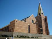
Lot 300 Money St Bunbury
Cnr Money and Parkfield Sts Comprises Parish House and site of former Cathedral
Presbytery
St Patrick's Church;
Bunbury
South West
Constructed from 1918 to 1951
| Type | Status | Date | Documents |
|---|---|---|---|
| Heritage List | Adopted | 15 Apr 2003 | |
| State Register | Registered | 12 Apr 2019 | HCWebsite.Listing+ListingDocument, HCWebsite.Listing+ListingDocument |
| Type | Status | Date | Documents |
|---|---|---|---|
| (no listings) |
| Type | Status | Date | Grading/Management | |
|---|---|---|---|---|
| Category | ||||
| Municipal Inventory | Adopted | 31 Jul 1996 | Exceptional Significance | |
The former Cathedral (1921) was demolished in 2005 after it was irrepairably damaged in a storm.
The Parish House shows evidence of some water damage since the May 2005 storm. There is some fretting and deterioration of bricks also. The Cathedral sufferred irrepairable damage in the storm and was demolished in July 2005.
| Name | Type | Year From | Year To |
|---|---|---|---|
| Richard Dennehy (cathedral, 1920) | Architect | - | - |
| Library Id | Title | Medium | Year Of Publication |
|---|---|---|---|
| 7299 | Bunbury images : people and places. | Book | 2004 |
| 7724 | Images CD No. 41: heritage assessments for St Patrick's Catholic Cathedral and Henton Cottage. | C D Rom | 2004 |
Individual Building or Group
| Epoch | General | Specific |
|---|---|---|
| Present Use | VACANT\UNUSED | Vacant\Unused |
| Original Use | RELIGIOUS | Church, Cathedral or Chapel |
| Original Use | RELIGIOUS | Housing or Quarters |
| Style |
|---|
| Federation Queen Anne |
| Type | General | Specific |
|---|---|---|
| Wall | BRICK | Common Brick |
| Roof | TILE | Other Tile |
| General | Specific |
|---|---|
| SOCIAL & CIVIC ACTIVITIES | Religion |
| DEMOGRAPHIC SETTLEMENT & MOBILITY | Settlements |
| SOCIAL & CIVIC ACTIVITIES | Community services & utilities |
This information is provided voluntarily as a public service. The information provided is made available in good faith and is derived from sources believed to be reliable and accurate. However, the information is provided solely on the basis that readers will be responsible for making their own assessment of the matters discussed herein and are advised to verify all relevant representations, statements and information.
Constructed from 1918
St Patrick’s Catholic Parish House, comprising a two-storey brick and tile residence in the Federation Queen Anne style has cultural heritage significance for the following reasons: the place was the centre of worship and religious activity for the Bunbury Roman Catholic Parish from 1918 to 2005 and is highly valued by the Bunbury community; the original 1918 portion of the Parish House is a fine example of domestic construction in the Federation Queen Anne style; the Parish House was the first building constructed on the site for the parish of Bunbury, and has been the residence of the priests who served the Catholic community of Bunbury since 1918. It was occupied by the Bishop of Bunbury from 1954 until the 1980s. The 1951 addition to the Parish House is of little significance. The Garage to the southwest of the Parish House is of little cultural heritage significance.
St Patricks Parish House is a two storey brick and tile house designed in the Federation Queen Anne style of architecture. The place was constructed in two stages. The first half of the Parish House was built in 1918 is in the Federation Queen Anne style. The second half constructed in 1951 is representative of the Post-War International style. The two-storey brick and tiled residence features faceted bays either side of the main entry at both levels topped with two prominent gablets with decorative timber inserts. The roof has terracotta roof finials and several tall chimneys with decorative mouldings. The roofs are pitched Marseille patterned terracotta tiles with a hipped broken back verandah. The two-storey constructed walls are painted white bricks that were previously tuck pointed with rendered sills and low arch lintels. The timber framed verandah has simple square posts to both levels with cross balustrading and arched corner brackets on upper floor only. The front door at ground floor level is timber panelled and half glazed, framed by half glazed side and fanlights. All glazed panels to the front door have richly coloured and patterned cast lead lights. The patterns contain church motifs including a chalice to the left side light. There is an original set of French half glazed doors with a fan light to the north facing wall in the Office 1, north of the main entry. The windows to the original Parish House are timber double hung with clear glass. The 1951 addition consists of a two-storey brick and tile structure to the north-western end of the building in the Post War International style. These additions house Parish Offices, Entry Hall, Chapter Hall, Meeting Room/Kitchenette on the ground floor and four Bedrooms, Bathroom, Ante Room, two Toilets and Balcony on the first floor level. As part of the 1951 additions, modifications were made to the original Parish House building. These consisted of the filling in of fireplaces and removal of fire place surrounds. An additional door was added under the staircase to the southern Verandah on the ground floor, probably for access to the Garages to the south of the building. Also noted on the 1951 plans is the removal of a timber screen to archway between the Central and Rear halls on the ground floor.
The original section of Parish House was built in 1918 under the direction of Archdeacon Smythe as a residence for priests. Prior to this, the Bunbury Presbytery for the Catholic priests was located on the corner of Wittenoon and Wellington Streets. In October 1951 Dean Wallace engaged J. Defillipo to build additions to the Presbytery at a cost of £750. Today the building is still used by the Catholic Diocese as a residence for priests as well as housing the offices of the Youth Worker.
High degree of integrity (original intent clear, current use compatible, high long term sustainability). High degree of authenticity with much original fabric remaining. (These statements based on street survey only).
Condition assessed as good (assessed from streetscape survey only).
This information is provided voluntarily as a public service. The information provided is made available in good faith and is derived from sources believed to be reliable and accurate. However, the information is provided solely on the basis that readers will be responsible for making their own assessment of the matters discussed herein and are advised to verify all relevant representations, statements and information.
1 Moore St Bunbury
Cnr Stirling St
Bunbury
South West
Constructed from 1898
| Type | Status | Date | Documents |
|---|---|---|---|
| Heritage List | Adopted | 15 Apr 2003 |
| Type | Status | Date | Documents |
|---|---|---|---|
| RHP - To be assessed | Current | 16 Apr 2004 |
| Type | Status | Date | Grading/Management | |
|---|---|---|---|---|
| Category | ||||
| Municipal Inventory | Adopted | 31 Jul 1996 | Considerable Significance | |
05698 Stirling Street Heritage Precinct
Individual Building or Group
| Epoch | General | Specific |
|---|---|---|
| Present Use | RESIDENTIAL | Single storey residence |
| Original Use | RESIDENTIAL | Single storey residence |
| Style |
|---|
| Victorian Georgian |
| Victorian Italianate |
| Type | General | Specific |
|---|---|---|
| Wall | BRICK | Rendered Brick |
| Roof | TILE | Aluminium Tile |
| General | Specific |
|---|---|
| PEOPLE | Famous & infamous people |
This information is provided voluntarily as a public service. The information provided is made available in good faith and is derived from sources believed to be reliable and accurate. However, the information is provided solely on the basis that readers will be responsible for making their own assessment of the matters discussed herein and are advised to verify all relevant representations, statements and information.
Constructed from 1898
House, 1 Moore Street, a single storey rendered brick and tile house, has cultural heritage significance for the following reasons: the place is an altered example of the Federation Queen Anne style of architecture; the place has landmark qualities and contributes significantly to the streetscape and the community's sense of place; the house was built as the family home of Bunbury-born Sir Newton Moore, future mayor of Bunbury, premier of Western Australia, agent-general in London for Western Australia and UK parliamentarian.
House, 1 Moore Street is a single storey rendered brick and tile house constructed in the Federation Queen Anne style of Architecture. The walls are rendered masonry. The roof is hipped and clad with tiles. The verandah is under a separate flat roof supported by steel posts. The asymmetrical front façade has a front door fitted with modern security screen with side and fanlights. To one side is a corner bay window and on the other is a protruding front room with gabled roof featuring a round vent. There is a small skillion roofed addition at the front of the house. There is a rendered chimney evident. The house is situated at street level. There is a timber picket fence to the front boundary line.
Moore Street is named after the Moore family which included Sir Newton Moore who was premier of Western Australia from 1906 to 1910. Previously Moore Street was known as Norwood Road. House, 1 Moore Street was built in 1898 for Newton J Moore and his wife. The land had been purchased the previous year by auctioneer James Moore, Newton’s father. The Moore family had a long association with the Bunbury area. Newton’s grandparents, John and Mary Moore and their three children arrived from Kent with the Australind settlers in 1842 on board the “Diadem.” Newton Moore was born in Bunbury on 17 May 1850 and received his early education in Bunbury under the instruction of George Teede. This was followed by a period in South Australia for higher schooling before being articled to Alexander Forrest as a surveyor. In 1893, Newton Moore worked in the South West as a government contract surveyor. He surveyed the Great Southern Railway and took a keen interest in forest resources the South West. He also promoted agriculture and immigration in the South West. Once back in Bunbury, Newton Moore became involved in politics. He was a Town councillor, Mayor (1902 – 1904), a member of the Legislative Assembly from 1904, Minister for Land (1905 – 1909), Colonial Treasurer (1909 – 1910) and then Premier from 1906 to 1910. In 1910 Moore was knighted and by 1912 was the Agent- General in London where he entered parliament once again and was the successful member for both North Islington and Richmond. He was much acclaimed for his finance and business acumen. Newton Moore died on 28 October 1936 and Lady Moore died on 15 February 1956. The Moores lived in House, 1 Moore Street until c 1910. By 1921, the house was owned by Harry Rendell and occupied by a Mr Veitch. Harry Rendell continued to own the house until the 1940s. Frederick Denny lived there in 1931 and Leo Bleakley in 1941. By 1951, House, 1 Moore Street was owned and occupied by G Atkins. House, 1 Moore Street has undergone several unsympathetic alterations over the years, including removal of the original verandah.
Medium degree of integrity (original intent partially clear, current use compatible, high long term sustainability). Medium degree of authenticity - alterations but with much original fabric remaining (These statements based on street survey only).
Condition assessed as good (assessed from streetscape survey only).
| Reserve | Lot/Location | Plan/Diagram | Vol/Folio |
|---|---|---|---|
| 7 | P001245 7 |
This information is provided voluntarily as a public service. The information provided is made available in good faith and is derived from sources believed to be reliable and accurate. However, the information is provided solely on the basis that readers will be responsible for making their own assessment of the matters discussed herein and are advised to verify all relevant representations, statements and information.
10 Moore St Bunbury
Bunbury
South West
Constructed from 1910
| Type | Status | Date | Documents |
|---|---|---|---|
| Heritage List | Adopted | 15 Apr 2003 |
| Type | Status | Date | Documents |
|---|---|---|---|
| RHP - To be assessed | Current | 14 Nov 2003 |
| Type | Status | Date | Grading/Management | |
|---|---|---|---|---|
| Category | ||||
| Municipal Inventory | Adopted | 31 Jul 1996 | Moderate Significance | |
05698 Stirling Street Heritage Precinct
Individual Building or Group
| Epoch | General | Specific |
|---|---|---|
| Original Use | RESIDENTIAL | Single storey residence |
| Present Use | RESIDENTIAL | Single storey residence |
| Style |
|---|
| Victorian Colonial |
| Type | General | Specific |
|---|---|---|
| Wall | TIMBER | Weatherboard |
| Roof | METAL | Corrugated Iron |
This information is provided voluntarily as a public service. The information provided is made available in good faith and is derived from sources believed to be reliable and accurate. However, the information is provided solely on the basis that readers will be responsible for making their own assessment of the matters discussed herein and are advised to verify all relevant representations, statements and information.

Constructed from 1910
House, 10 Moore Street, a single storey, single room width, timber framed and iron house has cultural heritage significance for the following reasons: the place is an example of the Federation Bungalow style of architecture; the place has landmark qualities and contributes significantly to the streetscape and the community's sense of place.
House, 10 Moore Street is a single storey, single room width, timber framed and iron house with asymmetrical facade designed as an example of the Federation Bungalow style of architecture. The walls are timber framed and clad with timber weatherboards. The roof is gabled and clad with corrugated iron. The verandah has a bullnose corrugated iron roof supported by chamfered timber posts with decorative timber brackets. The front door is recessed to one side and the front room has timber framed double hung sash windows. There is a timber clad addition at the rear.
Moore Street is named after the Moore family which included Sir Newton Moore who was premier of Western Australia from 1906 to 1910. Previously Moore Street was known as Norwood Road. The area was subdivided in 1897/98 by Edwin Thomas as the Norwood Park Estate. The date of construction of House, 10 Moore Street has not been determined as no entries for the lot could be found in the Bunbury Rate Books prior to 1921. It is thought that the house was built c. 1910. In 1921, House, 10 Moore Street was owned and occupied by Luke Smith, a lumper. Luke Smith was still the owner in 1931, at which time it was numbered 9 Moore Street. Thomas McLenron owned and occupied the house from the mid 1940s until at least the early 1950s.
High degree of integrity (original intent clear, current use compatible, high long term sustainability). Medium degree of authenticity - alterations but with much original fabric remaining (These statements based on street survey only).
Condition assessed as good (assessed from streetscape survey only).
| Reserve | Lot/Location | Plan/Diagram | Vol/Folio |
|---|---|---|---|
| 55 | P027556 55 | VOL2036FOL300 |
This information is provided voluntarily as a public service. The information provided is made available in good faith and is derived from sources believed to be reliable and accurate. However, the information is provided solely on the basis that readers will be responsible for making their own assessment of the matters discussed herein and are advised to verify all relevant representations, statements and information.
11 Moore St Bunbury
Bunbury
South West
Constructed from 1910
| Type | Status | Date | Documents |
|---|---|---|---|
| Heritage List | Adopted | 15 Apr 2003 |
| Type | Status | Date | Documents |
|---|---|---|---|
| RHP - To be assessed | Current | 14 Nov 2003 |
| Type | Status | Date | Grading/Management | |
|---|---|---|---|---|
| Category | ||||
| Municipal Inventory | Adopted | 31 Jul 1996 | Moderate Significance | |
05698 Stirling Street Heritage Precinct
Individual Building or Group
| Epoch | General | Specific |
|---|---|---|
| Original Use | RESIDENTIAL | Single storey residence |
| Present Use | RESIDENTIAL | Single storey residence |
| Style |
|---|
| Federation Arts and Crafts |
| Type | General | Specific |
|---|---|---|
| Roof | METAL | Corrugated Iron |
| Wall | TIMBER | Weatherboard |
This information is provided voluntarily as a public service. The information provided is made available in good faith and is derived from sources believed to be reliable and accurate. However, the information is provided solely on the basis that readers will be responsible for making their own assessment of the matters discussed herein and are advised to verify all relevant representations, statements and information.

Constructed from 1910
House, 11 Moore Street, a single storey timber and iron house has cultural heritage significance for the following reasons: the place is a fine example of the Federation Arts and Crafts style of architecture; the place has landmark qualities and contributes significantly to the streetscape and the community's sense of place.
House, 11 Moore Street is a single storey timber and iron house constructed in the Federation Arts and Crafts style of Architecture. The walls are timber framed and clad with timber weatherboards. The roof is hipped and clad with corrugated iron with two gables on either side featuring decorative timber elements. The verandah is under a continuous corrugated iron roof. There is a rendered chimney evident. The house is situated at street level. There is a timber picket fence to the front boundary line. The symmetrical front façade has a central front door. Vegetation makes further description difficult.
Moore Street is named after the Moore family which included Sir Newton Moore who was premier of Western Australia from 1906 to 1910. Previously Moore Street was known as Norwood Road. The area was subdivided in 1897/98 by Edwin Thomas as the Norwood Park Estate. The date of construction of House, 10 Moore Street has not been determined as no entries for the lot could be found in the Bunbury Rate Books prior to 1921. It is thought that the house was built c. 1910. In 1921, House, 11 Moore Street was owned by Peter Rogers and occupied by a Mr or Mrs Ingham. Peter Rogers also owned the adjacent lot, which was vacant land at this time. In 1931, at which time it was numbered 8 Moore Street, the house was occupied by Robina Hanson. Florence Hanson was the owner and occupier in 1941 and Florence and Christian Hanson were listed as the owners and occupiers in 1951.
High degree of integrity (original intent clear, current use compatible, high long term sustainability). High degree of authenticity with much original fabric remaining. (These statements based on street survey only).
Condition assessed as good (assessed from streetscape survey only).
| Reserve | Lot/Location | Plan/Diagram | Vol/Folio |
|---|---|---|---|
| SL1 | S061584 | VOL2843FOL749 |
This information is provided voluntarily as a public service. The information provided is made available in good faith and is derived from sources believed to be reliable and accurate. However, the information is provided solely on the basis that readers will be responsible for making their own assessment of the matters discussed herein and are advised to verify all relevant representations, statements and information.
15 Moore St Bunbury
Washingtonia Palm Tree only remains
Bunbury
South West
Constructed from 1900
| Type | Status | Date | Documents |
|---|---|---|---|
| (no listings) |
| Type | Status | Date | Documents |
|---|---|---|---|
| RHP - To be assessed | Current | 14 Nov 2003 |
| Type | Status | Date | Grading/Management | |
|---|---|---|---|---|
| Category | ||||
| Municipal Inventory | Adopted | 31 Jul 1996 | Historic Site | |
05698 Stirling Street Heritage Precinct
Individual Building or Group
| Epoch | General | Specific |
|---|---|---|
| Present Use | VACANT\UNUSED | Vacant\Unused |
| Original Use | RESIDENTIAL | Single storey residence |
| Style |
|---|
| Federation Carpenter Gothic |
| Type | General | Specific |
|---|---|---|
| Roof | METAL | Corrugated Iron |
| Wall | TIMBER | Weatherboard |
This information is provided voluntarily as a public service. The information provided is made available in good faith and is derived from sources believed to be reliable and accurate. However, the information is provided solely on the basis that readers will be responsible for making their own assessment of the matters discussed herein and are advised to verify all relevant representations, statements and information.
Constructed from 1900
DEMOLISHED The site of House, 15 Moore Street has historic significance for the large weatherboard home that may have been designed by architect, Eustace Cohen.
DEMOLISHED
House, 15 Moore Street was built c 1920. It is not known if there was an earlier house on the site. The land was part of the Norwood Park subdivision, which was carved up by Newton Moore and Edwin Herbert in 1896/97. William Stanger, a carter who rented his shop from the Hadlow brothers, purchased the block in January 1898. House, 15 Moore Street was a spacious weatherboard and iron home, with half-timbered gables, exposed structural timber and other semi-decorative timber work typical of the period. It has been speculated that it was designed by architect E G Cohen, given the similarity to another of his works at 16 Spencer Street. This would date the building to c 1920. The house was demolished in 1993 and in 2001, the lot was still vacant. The only visible remains of the earlier use was a Washingtonia Palm tree at the rear of the block.
DEMOLISHED
No visible remains
| Name | Type | Year From | Year To |
|---|---|---|---|
| Eustace Cohen (Not confirmed) | Architect | - | - |
| Reserve | Lot/Location | Plan/Diagram | Vol/Folio |
|---|---|---|---|
| 102 | P033478 102 | VOL2527FOL892 |
This information is provided voluntarily as a public service. The information provided is made available in good faith and is derived from sources believed to be reliable and accurate. However, the information is provided solely on the basis that readers will be responsible for making their own assessment of the matters discussed herein and are advised to verify all relevant representations, statements and information.
20 Moore St Bunbury
Bunbury
South West
Constructed from 1890
| Type | Status | Date | Documents |
|---|---|---|---|
| Heritage List | Adopted | 15 Apr 2003 |
| Type | Status | Date | Documents |
|---|---|---|---|
| RHP - To be assessed | Current | 14 Nov 2003 |
| Type | Status | Date | Grading/Management | |
|---|---|---|---|---|
| Category | ||||
| Municipal Inventory | Adopted | 31 Jul 1996 | Moderate Significance | |
05698 Stirling Street Heritage Precinct
Individual Building or Group
| Epoch | General | Specific |
|---|---|---|
| Original Use | RESIDENTIAL | Single storey residence |
| Present Use | RESIDENTIAL | Single storey residence |
| Type | General | Specific |
|---|---|---|
| Wall | TIMBER | Weatherboard |
| Roof | METAL | Corrugated Iron |
This information is provided voluntarily as a public service. The information provided is made available in good faith and is derived from sources believed to be reliable and accurate. However, the information is provided solely on the basis that readers will be responsible for making their own assessment of the matters discussed herein and are advised to verify all relevant representations, statements and information.
Constructed from 1890
House, 20 Moore Street, a single storey timber and iron house has cultural heritage significance for the following reasons: the place is an example of the Federation Bungalow style of architecture; the place has landmark qualities and contributes significantly to the streetscape and the community's sense of place.
House, 20 Moore Street is a single storey timber and iron house constructed in the Federation Bungalow style of architecture. The walls are timber framed and clad with timber weatherboards. The roof is hipped and gabled and clad with corrugated iron. The gable end features decorative timber detailing and finial. The verandah is under a separate corrugated iron bullnose roof with decorative timber frieze. The house is situated at street level. There is a timber picket fence to the side boundary line. Garden vegetation obscures much of the building fabric from street view.
House, 20 Moore Street was built c 1900. No information on the house was found in available Rate Books. The area was subdivided in 1897/98 by Edwin Thomas as the Norwood Park Estate.Moore Street is named after the Moore family which included Sir Newton Moore who was premier from 1906 to 1910. Previously Moore Street was known as Norwood Road.
High degree of integrity (original intent clear, current use compatible, high long term sustainability). High degree of authenticity with much original fabric remaining. (These statements based on street survey only).
Condition assessed as good (assessed from streetscape survey only).
| Reserve | Lot/Location | Plan/Diagram | Vol/Folio |
|---|---|---|---|
| 100 | D091198 100 | VOL2090FOL324 |
This information is provided voluntarily as a public service. The information provided is made available in good faith and is derived from sources believed to be reliable and accurate. However, the information is provided solely on the basis that readers will be responsible for making their own assessment of the matters discussed herein and are advised to verify all relevant representations, statements and information.