Local Government
Bunbury
Region
South West
11 Jarrah St Bunbury
Bunbury
South West
Constructed from 1916
| Type | Status | Date | Documents |
|---|---|---|---|
| Heritage List | Adopted | 15 Apr 2003 |
| Type | Status | Date | Documents |
|---|---|---|---|
| (no listings) |
| Type | Status | Date | Grading/Management | |
|---|---|---|---|---|
| Category | ||||
| Municipal Inventory | Adopted | 31 Jul 1996 | Moderate Significance | |
Individual Building or Group
| Epoch | General | Specific |
|---|---|---|
| Original Use | RESIDENTIAL | Single storey residence |
| Present Use | RESIDENTIAL | Single storey residence |
| Type | General | Specific |
|---|---|---|
| Wall | TIMBER | Weatherboard |
| Roof | METAL | Corrugated Iron |
| Wall | ASBESTOS | Fibrous Cement, flat |
This information is provided voluntarily as a public service. The information provided is made available in good faith and is derived from sources believed to be reliable and accurate. However, the information is provided solely on the basis that readers will be responsible for making their own assessment of the matters discussed herein and are advised to verify all relevant representations, statements and information.

Constructed from 1915
House, 11 Jarrah Street, a single storey timber and iron house House, has cultural heritage significance for the following reasons: the place is a good example of a house constructed during WWI with elements of both the Federation Arts and Crafts and Federation Bungalow styles of Architecture; the place has landmark qualities and contributes significantly to the streetscape of the Tree Street area and the community's sense of place.
House, 11 Jarrah Street is a single storey timber and iron house constructed during WWI it has elements of both the Federation Arts and Crafts and Federation Bungalow styles of Architecture. The walls are timber framed and clad with timber weatherboards and fibre cement sheeting. The roof is hipped and gabled and clad with corrugated iron. The gable ends have decorative timber features. A set of four casement windows are covered with an almost flat corrugated iron awning supported at each end by a timber strut. The verandah is under a separate corrugated iron roof supported by chamfered timber posts with decorative timber brackets and timber balustrade. A separate flat roof is located over the verandah. The asymmetrical front façade has a French style front door with casement windows to one side. There is another entrance door leading into a front sleep-out featuring fibre cement sheet walls with decorative timber features and coach style windows. There are two rendered chimneys with chimney pots evident. There is a timber picket fence to the front boundary line.
Jarrah Street is one of the streets in the ‘Tree Street Area’, where the streets are named after indigenous flora. Jarrah (Eucalyptus marginata) grew profusely in the district prior to European settlement. It was often called ‘Australian mahogany’ because of its red colour and because it was an important export for the infant port of Bunbury. The date of construction of House, 11 Jarrah Street has not been determined as entries of the lot could not be found in the Bunbury Rate Books prior to 1921. The land on which the house stands was originally part of the Stirling Estate, which was subdivided by W B Mitchell c 1896. It is thought that House, 2 Jarrah Street was constructed c. 1915 and may have been built by local contractors, Hough and Sons. In 1921, House, 11 Jarrah Street was owned and occupied by Frederick Donaldson, a foreman. At this time, the house was numbered 62 Jarrah Street. By 1941 ownership had changed to Edith Mary Donaldson.
High degree of integrity (original intent clear, current use compatible, high long term sustainability). Medium degree of authenticity - alterations but with much original fabric remaining (These statements based on street survey only).
Condition assessed as good (assessed from streetscape survey only).
| Reserve | Lot/Location | Plan/Diagram | Vol/Folio |
|---|---|---|---|
| 62 | P000318 62 | VOL1257FOL368 |
This information is provided voluntarily as a public service. The information provided is made available in good faith and is derived from sources believed to be reliable and accurate. However, the information is provided solely on the basis that readers will be responsible for making their own assessment of the matters discussed herein and are advised to verify all relevant representations, statements and information.
16 Jarrah St Bunbury
Bunbury
South West
Constructed from 1905
| Type | Status | Date | Documents |
|---|---|---|---|
| Heritage List | Adopted | 15 Apr 2003 |
| Type | Status | Date | Documents |
|---|---|---|---|
| (no listings) |
| Type | Status | Date | Grading/Management | |
|---|---|---|---|---|
| Category | ||||
| Municipal Inventory | Adopted | 31 Jul 1996 | Moderate Significance | |
Individual Building or Group
| Epoch | General | Specific |
|---|---|---|
| Original Use | RESIDENTIAL | Single storey residence |
| Present Use | RESIDENTIAL | Single storey residence |
| Style |
|---|
| Federation Bungalow |
| Type | General | Specific |
|---|---|---|
| Roof | METAL | Corrugated Iron |
| Wall | BRICK | Painted Brick |
This information is provided voluntarily as a public service. The information provided is made available in good faith and is derived from sources believed to be reliable and accurate. However, the information is provided solely on the basis that readers will be responsible for making their own assessment of the matters discussed herein and are advised to verify all relevant representations, statements and information.

Constructed from 1905
House, 16 Jarrah Street is a single storey, brick, rendered masonry and iron house has cultural heritage significance for the following reasons: the place is a good example of the Federation Bungalow style of architecture; the place has landmark qualities and contributes significantly to the streetscape of the Tree Street area and the community's sense of place.
House, 16 Jarrah Street is a single storey, brick, rendered masonry and iron house with an asymmetrical facade designed as an example of the Federation Bungalow style of architecture. The walls are rendered masonry. The roof is hipped and gabled and clad with corrugated iron. The gable ends have decorative timber screens and finials. The verandah has a separate corrugated iron bullnose roof and is supported by chamfered timber posts with decorative iron brackets and frieze. The front door has sidelights flanked to one side by timber framed double hung sash windows. The protruding front room has two sets of timber framed double hung sash windows. There is a rendered chimney evident. There is a low rendered masonry retaining wall to the front boundary line. Previous descriptive notes state: Lattice verandah panels visible in 1978 BNES image have been removed and the verandah space under a bull nose roof, has been opened up.
Jarrah Street is one of the streets in the ‘Tree Street Area’, where the streets are named after indigenous flora. Jarrah (Eucalyptus marginata) grew profusely in the district prior to European settlement. It was often called ‘Australian mahogany’ because of its red colour and because it was an important export for the infant port of Bunbury. The date of construction of House, 16 Jarrah Street has not been determined as entries of the lot could not be found in the Bunbury Rate Books prior to 1931. The land on which the house stands was originally part of the Stirling Estate, which was subdivided by W B Mitchell c 1896. It is thought that House, 16 Jarrah Street was constructed c. 1905 In 1931, Blanche Sloan was listed as the owner and occupier of House, 16 Jarrah Street. She was still living there in 1951.
High degree of integrity (original intent clear, current use compatible, high long term sustainability). Medium degree of authenticity - alterations but with much original fabric remaining (These statements based on street survey only).
Condition assessed as good (assessed from streetscape survey only).
| Reserve | Lot/Location | Plan/Diagram | Vol/Folio |
|---|---|---|---|
| 96 | P000318 96 | VOL346FOL32 |
This information is provided voluntarily as a public service. The information provided is made available in good faith and is derived from sources believed to be reliable and accurate. However, the information is provided solely on the basis that readers will be responsible for making their own assessment of the matters discussed herein and are advised to verify all relevant representations, statements and information.
2 Jarrah St Bunbury
Cnr Stockley Rd
Bunbury
South West
Constructed from 1905
| Type | Status | Date | Documents |
|---|---|---|---|
| Heritage List | Adopted | 15 Apr 2003 |
| Type | Status | Date | Documents |
|---|---|---|---|
| (no listings) |
| Type | Status | Date | Grading/Management | |
|---|---|---|---|---|
| Category | ||||
| Municipal Inventory | Adopted | 31 Jul 1996 | Considerable Significance | |
Individual Building or Group
| Epoch | General | Specific |
|---|---|---|
| Original Use | RESIDENTIAL | Single storey residence |
| Present Use | RESIDENTIAL | Single storey residence |
| Type | General | Specific |
|---|---|---|
| Roof | METAL | Corrugated Iron |
| Wall | TIMBER | Weatherboard |
| Wall | TIMBER | Other Timber |
This information is provided voluntarily as a public service. The information provided is made available in good faith and is derived from sources believed to be reliable and accurate. However, the information is provided solely on the basis that readers will be responsible for making their own assessment of the matters discussed herein and are advised to verify all relevant representations, statements and information.

Constructed from 1905
Lyndhurst, 2 Jarrah Street, a single storey timber and iron house House, has cultural heritage significance for the following reasons: the place is a fine example of the Federation Queen Anne style of architecture; the place has landmark qualities and contributes significantly to the streetscape of the Tree Street area and the community's sense of place.
Lyndhurst is a single storey timber and iron house constructed in the Federation Queen Anne style of Architecture. The walls are timber framed and clad with timber weatherboards. The roof is hipped and clad with corrugated iron. The verandah is under a separate corrugated iron bullnose roof supported by chamfered and turned timber posts with decorative timber brackets and frieze. There is a lean-to verandah on one side. The symmetrical front façade has a central front door with sidelights flanked on either side by timber framed double hung sash windows with sidelights and modern security screens fitted. There is a rendered chimney evident. The house is situated at street level. There is a timber picket fence to the front boundary line. Previous descriptive notes state: The interior featured pressed metal lined walls and ceilings with some lath and plaster.
Jarrah Street is one of the streets in the ‘Tree Street Area’, where the streets are named after indigenous flora. Jarrah (Eucalyptus marginata) grew profusely in the district prior to European settlement. It was often called ‘Australian mahogany’ because of its red colour and because it was an important export for the infant port of Bunbury. The date of construction of House, 2 Jarrah Street has not been determined as entries of the lot could not be found in the Bunbury Rate Books prior to 1921. The land on which the house stands was originally part of the Stirling Estate, which was subdivided by W B Mitchell c 1896. It is thought that House, 2 Jarrah Street was constructed c. 1905. In 1921, House, 2 Jarrah Street was owned by a Mr Goldsmith. In that year, it was purchased by Charles Henry Tomkinson, a butcher. Mr Tomkinson was still the owner and occupant in 1951.
High degree of integrity (original intent clear, current use compatible, high long term sustainability). High degree of authenticity with much original fabric remaining. (These statements based on street survey only).
Condition assessed as good (assessed from streetscape survey only).
| Reserve | Lot/Location | Plan/Diagram | Vol/Folio |
|---|---|---|---|
| 87 | P000318 87 | VOL1441FOL568 |
This information is provided voluntarily as a public service. The information provided is made available in good faith and is derived from sources believed to be reliable and accurate. However, the information is provided solely on the basis that readers will be responsible for making their own assessment of the matters discussed herein and are advised to verify all relevant representations, statements and information.
44 Jarvis St Bunbury
Bunbury
South West
Constructed from 1894
| Type | Status | Date | Documents |
|---|---|---|---|
| Heritage List | Adopted | 15 Apr 2003 |
| Type | Status | Date | Documents |
|---|---|---|---|
| RHP - Assessed - Below Threshold | Current | 31 Jul 2015 |
| Type | Status | Date | Grading/Management | |
|---|---|---|---|---|
| Category | ||||
| Municipal Inventory | Adopted | 31 Jul 1996 | Considerable Significance | |
| Register of the National Estate | Indicative Place | |||
| Classified by the National Trust | Classified | 04 May 1981 | ||
The Bungalow Cottage, Bunbury, a five room residence constructed in Bunbury basalt rock, with an asbestos cement roof and timber framed verandah, is a rare example of the use of Bunbury basalt in the construction of a residence in Western Australia. The 2014/2015 addition constructed to the rear of the property does not contributed to the significance of the place.
The Bungalow Cottage, Bunbury is a modest five room single-storey Victorian Georgian residence constructed between 1894 and 1920. It has an asbestos cement roof and timber framed verandah. The stone is locally sourced Bunbury basalt.
The Bungalow Cottage, Bunbury is located at 44 Jarvis Road, Bunbury, west of Big Swamp Parkland to the south of the main Bunbury township. The property was originally part of a much larger allotment, initially owned by Ephraim Mayo Clarke, a well-known Bunbury identity and later Member of the Legislative Council of Western Australia. In 1912 Clarke acquired the portion of Leschenault Location 26 within which The Bungalow Cottage, Bunbury is located. An annotation on the Certificate of Title notes that Elizabeth Holywell and Ross Jarvis, both of Bunbury, had each arranged to purchase portions of Clarke’s land. By 1919, a significant portion of the Clarke property, including the lot comprising The Bungalow Cottage, Bunbury, was transferred to Mrs Elizabeth Holywell. It is claimed that Bungalow Cottage was built by the Holywell family in 1894, utilising the local basalt stone that was a significant feature of the local area, however it does not appear to have been in Holywell hands until the early twentieth century. By 1909, Elizabeth Holywell had established a dairy on Beach Road in South Bunbury, and by 1913 was advertising the supply of fresh milk twice daily as ‘the proprietor E. Holywell of Hildaville Dairy’. The Holywell family and their dairy were well-known in the district. In 1938, Elizabeth Holywell acquired an additional portion of land, approximately two acres, on the western side of her Jarvis Street property, adjacent to The Bungalow Cottage, Bunbury. Although the Hildaville Dairy was located north of the The Bungalow Cottage, Bunbury, on Beach Road, it is likely that the new properties were also utilised for dairying and farming purposes. Holywell Road in South Bunbury, located south of the Beach Road dairy, and west of The Bungalow Cottage, Bunbury, is thought to have been named after the Holywell family and their dairying activities. Although The Bungalow Cottage, Bunbury was constructed in the Victorian Georgian style that was common in the late nineteenth century, it is possible that it is a late example of the style and could have been constructed as late as 1920. The Bungalow Cottage, Bunbury is also a rare example of the use of Bunbury basalt in the construction of a residence. Bunbury basalt is the term given for the black basalt formation present along the beach front at Bunbury, and also in Capel and Black Point in D’Entrecasteaux in the south-Western Australia. As with other basalt formations, Bunbury Basalt is a fine-grained hard rock usually black or grey in colour. The basalt used in The Bungalow Cottage, Bunbury is thought to have been extracted from the former quarry located along the Bunbury shorefront. The quarry was operational between 1890 and the 1960s and supplied crushed basalt gravel used to make asphalt for road construction. Bunbury basalt does not appear to have been regularly used in building construction, possibly due to the vesicular texture and rough appearance of the stones. An 1959 aerial photograph of South Bunbury indicates that The Bungalow Cottage, Bunbury was the only building along Jarvis Street at that time. The surrounding land appears to be partially in use as pasture or farmland. The Bungalow Cottage, Bunbury is still in use as a private residence
Good
Individual Building or Group
| Epoch | General | Specific |
|---|---|---|
| Original Use | RESIDENTIAL | Single storey residence |
| Present Use | RESIDENTIAL | Single storey residence |
| Style |
|---|
| Victorian Colonial |
| Type | General | Specific |
|---|---|---|
| Wall | STONE | Local Stone |
| Roof | ASBESTOS | Fibrous Cement, corrugated |
| General | Specific |
|---|---|
| DEMOGRAPHIC SETTLEMENT & MOBILITY | Settlements |
This information is provided voluntarily as a public service. The information provided is made available in good faith and is derived from sources believed to be reliable and accurate. However, the information is provided solely on the basis that readers will be responsible for making their own assessment of the matters discussed herein and are advised to verify all relevant representations, statements and information.

Constructed from 1894
The Bungalow Cottage, 44 Jarvis Street is a single storey, stone and asbestos house has cultural heritage significance for the following reasons: the place is an example of the Victorian Georgian style of architecture; the place has landmark qualities and contributes significantly to the streetscape and the community's sense of place; the place has rariety value for its use of basalt rock, quarried locally and fashioned into building blocks; and the place has historic value for its associations with Hollywell family who were assciated with the early settlement of Australind.
The Bungalow Cottage, 44 Jarvis Street is a single storey, stone and asbestos house with a symmetrical facade designed as simple example of the Victorian Georgian style of architecture. The walls are Basaltic rock. The roof is hipped and clad with asbestos. The front verandah has a continuous asbestos roof, extends around one side of the building and is supported by simple square timber posts. There is a rendered corbelled chimney evident. There is a wall along the boundary line constructed of the same basaltic rock with piers supporting iron posts. Thick vegetation between the piers obscured visibility making further description difficult.
Jarvis Street is named for James Jarvis, who arrived at Australind in 1842 on the ‘Trusty’ with his wife and child. After living in Fremantle for some years, the family moved to farm in Bunbury in the 1890s. Known as ‘Bungalow Cottage’, 44 Jarvis Street, was built by and for the Hollywell family c 1894. Built from quarried and shaped basaltic rock, Bungalow Cottage is an unusual house in Bunbury. The Bunbury basalt extrusion has resulted from eons of volcanic activity caused by Continental drift and is a significant feature of the local landscape. In 1931, House, 44 Jarvis Street was owned and occupied by Elizabeth Holywell. When Elizabeth died sometime in the 1930s, ownership passed to her estate and Miss Hilda Holywell took up occupation. By 1951, Hilda was listed as the owner and occupier of House, 44 Jarvis Street.
High degree of integrity (original intent clear, current use compatible, high long term sustainability). Medium degree of authenticity - alterations but with much original fabric remaining (These statements based on street survey only). The roof has been replaced with asbestos at some stage and some modifications have been carried out over time. The kitchen and verandahs were added later than 1898. The original basaltic fabric is largely intact and the same product has been used to recently construct a fence which complements the original design of the house.
Condition assessed as good (assessed from streetscape survey only).
| Reserve | Lot/Location | Plan/Diagram | Vol/Folio |
|---|---|---|---|
| 28 | P016392 28 | VOL1823FOL615 |
This information is provided voluntarily as a public service. The information provided is made available in good faith and is derived from sources believed to be reliable and accurate. However, the information is provided solely on the basis that readers will be responsible for making their own assessment of the matters discussed herein and are advised to verify all relevant representations, statements and information.
Lot 1036 Jetty Rd Bunbury
Outer Harbour Jetty
Bunbury
South West
Constructed from 1864 to 1998
| Type | Status | Date | Documents |
|---|---|---|---|
| Heritage List | Adopted | 15 Apr 2003 | |
| State Register | Registered | 07 Jan 2000 | HCWebsite.Listing+ListingDocument, HCWebsite.Listing+ListingDocument |
| Type | Status | Date | Documents |
|---|---|---|---|
| (no listings) |
| Type | Status | Date | Grading/Management | |
|---|---|---|---|---|
| Category | ||||
| Register of the National Estate | Indicative Place | |||
| Statewide Lge Timber Str Survey | Completed | 11 Dec 1998 | ||
| Port-related Structures Survey | Completed | 31 Oct 1995 | ||
| Municipal Inventory | Adopted | 31 Jul 1996 | Execptional Significance | |
| Library Id | Title | Medium | Year Of Publication |
|---|---|---|---|
| 6532 | Western Australian endangered places 2003. | Kit | 2003 |
| 6442 | Bunbury timber jetty : conservation plan. | Heritage Study {Cons'n Plan} | 2003 |
| 6342 | Bunbury Harbour City - Marlston Hill development - proposed changes to environmental conditions : report and recommendations of the Environmental Protection Authority. | Report | 1995 |
| 6360 | 2020 vision : Port strategy. | Report | 2000 |
| 6341 | Bunbury Harbour City development : Report and recommendations of the Environmental Protection Authority. | Report | 1992 |
| 9245 | Arrol Crane (Bunbury Timber Jetty). | Heritage Study {Cons'n Plan} | 2008 |
Historic site
| Epoch | General | Specific |
|---|---|---|
| Original Use | Transport\Communications | Water: Jetty |
| Present Use | Transport\Communications | Water: Jetty |
| Type | General | Specific |
|---|---|---|
| Other | TIMBER | Other Timber |
| General | Specific |
|---|---|
| OCCUPATIONS | Rural industry & market gardening |
| OCCUPATIONS | Fishing & other maritime industry |
| SOCIAL & CIVIC ACTIVITIES | Sport, recreation & entertainment |
| TRANSPORT & COMMUNICATIONS | River & sea transport |
This information is provided voluntarily as a public service. The information provided is made available in good faith and is derived from sources believed to be reliable and accurate. However, the information is provided solely on the basis that readers will be responsible for making their own assessment of the matters discussed herein and are advised to verify all relevant representations, statements and information.
Constructed from 1864, Constructed from 1872
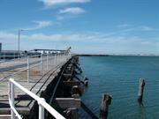
Timber Jetty, Bunbury Harbour, a timber jetty about 590 metres long, and situated at the end of a stone causeway, has cultural heritage significance for the following reasons: the place transformed Koombana Bay into a viable docking location and was therefore the means whereby Bunbury developed from a small country town to a major port and port of call; the place was an important centre for the south-west industries, in particular timber, and gave the region the opportunity to reach national and world markets with its produce; the place dates from 1864 when it was built with labour supplied by a convict work gang working for local contractor, William Forrest ; the place continues to have social significance as a recreational fishing facility; and, the place has aesthetic value in itself, as a landmark and in its contribution to the maritime precinctual environment. The sheds, railway lines and points switching mechanism located on Bunbury Timber Jetty, and the crane situated at the end of the causeway have cultural heritage significance and contribute to the understanding of the place as a working port.
Bunbury Timber Jetty is situated in Koombana Bay, at the end of a stone causeway. From the end of the stone causeway the jetty extends north-east for about 380 metres and then changes direction to extend east-north-east for about 210 metres. The following physical description is based on the Heritage Council of Western Australia’s Assessment Documentation: The stone causeway was built in 1967 and commences at the end of Henry Street. The stone causeway is aligned along a south-west to north-west axis, is about 30 metres wide, has a public bitumen road, and terminates at the Bunbury Timber Jetty. Near the end of the causeway is a large crane that straddles the bitumen road. This crane has been relocated from the jetty to its present location in recent times. The crane is supported by four large stanchions, two to each side of the road, which in turn are supported by railway wheels. On the north-west side the crane bears an inscription which reads as follows: SIR WILLIAM ARROL AND CO LTD PARKHEAD GLASGOW ORDER 543 LOAD 3 TONS 1911 Immediately beyond the crane the bitumen road ends and is replaced by a road formed from crushed limestone. The causeway is terminated by a narrow breakwater, crescent shaped in plan, which provides additional protection to the boat harbour immediately west of the causeway. In recent times the Bunbury Timber Jetty Preservation Society (Inc) have extended the 1967 causeway by about thirty metres to link with Bunbury Timber Jetty, near the start of the 1906 jetty extensions. Bunbury Timber Jetty, commencing from the end of the extended causeway, extends north-east for about 380 metres and then changes direction to extend east-north-east for about 210 metres. The construction of Bunbury Timber Jetty is as follows: (All dimensions are approximate) Timber piles, 450 mm in diameter are located at four metres centres longitudinally and two metres laterally. Located at a height which corresponds roughly with high tide level, two horizontal members (or walings) about 300 mm by 150 mm in section, are transversely fixed to the piles, one to each side, by means of a single bolted connection which passes through both walings and the pier in between. Positioned transversely and over the walings are cross braces, 300 mm by 120 mm in section and aligned about 30 degrees above the horizontal. Each cross brace spans across two pier bays, from directly below the longitudinal decking beams to a point immediately over the walings. At the centre of the resultant ‘X’ shape, a single bolt connects the two cross braces and the pier in between. Each pair of braces is generally adjacent to another pair of braces, with a shared pier in between. There is no evidence of cross bracing running in the longitudinal direction. The heads of the piers are notched at each side to provide bearing for a pair of 300mm by 120mm transverse beams (or half caps). The transverse beams vary in length and span up to three pier bays. The joints in each pair of beams do not align but are staggered to maximise structural integrity. The transverse beams have a joint at mid span that consists of a packer of the same depth as the transverse beams and the same width as the notched pier head. The ends of the transverse beams, the corresponding continuous transverse beam and the packer in between are joined with four or more bolts. Sitting on top of, and at right angles to, the transverse beams are decking beams, spaced at approximately one metre centres. The decking beams are joined in two ways. The first method occurs on that section of jetty that extends from the causeway to point where the change in direction occurs, and consists of a simple bolted connection through the decking beam and the transverse beam under it. The second method, employed on the outer section of Bunbury Timber Jetty uses timber corbels, 1200mm long, 350mm deep and 300mm wide and aligned longitudinally, in the same direction as the decking beams. The decking beams are bolted to the corbels. This method is an improvement on the first method in that the horizontal distance between the fixing point at the end of the decking beam is increased, thus minimising splitting of the decking beam. Generally, the decking beams provide the only longitudinal bracing for Bunbury Timber Jetty. In a few isolated cases, longitudinal timber bracing members have been fixed at a later date. The decking timbers, 250mm wide and 100mm deep, are laid at right angles to, and fixed to the decking beams by means of iron spikes about 25mm long, with one spike at each end of each decking timber. The joints are staggered in some locations and aligned in others. Occasionally, to reduce bowing, two spikes are used at the ends of the decking timbers. In order to facilitate the loading of cargo, railway lines were installed in 1899 on Bunbury Timber Jetty.
Timber Jetty was originally constructed in 1864 by convicts and was the first harbour loading facility in Bunbury. William Forrest, the father of Sir John and Alexander, was contracted to build the jetty at a cost of £200. The jetty was built in a north east direction and into seven feet of water. H. W. Gillman, an ex-convict, supplied the timber for £339 and the jetty was built with labour from a supervised convict gang who had come from Fremantle. When completed the jetty was 1400ft (427m) long and held together with wooden dowels rather than bolts. The building of the jetty marked the first stage of growth in the Bunbury area. This was a result of a shift from being a district of consumers to producers. The construction of the jetty allowed for the export of produce including grain, wool and timber to other ports in Australia and the world. With this increased activity the jetty struggled to keep up with the demand of ships who wished to load or unload cargo. There were also problems with silt building up around the pylons preventing deep moorings. These factors resulted in the jetty being extended many times into deeper water. To overcome the silting problem these new extensions were built at angles. In all there were 11 extensions to the Bunbury Jetty between 1865 and 1957 and it reached a final length of 4,550 feet (1804m). In 1899 the jetty was connected to the railway and as a result it was not uncommon to see 20 ships waiting to dock. A goods shed, water supply, donkey engines, five electric cranes and a steam crane were added to help with loading and unloading. In 1909, the Bunbury Harbour Trust Act was passed and five commissioners were appointed to control all harbour matters. The deterioration of the older parts of the jetty was an ongoing problem for the Harbour Board, who in 1921 paid £2,462 for maintenance expenses alone. In January 1921 a regular Bunbury – Fremantle shipping schedule began and by 1923 Bunbury was still considered to be the principal port of the southern districts. Bulk handling facilities for wheat were introduced in 1937 which helped increase the potential of the port, especially after decline in shipping during the Great Depression. The Government employed F. W. Tydeman to report on Bunbury Harbour and submit a scheme for further development in 1948. The ‘Tydeman Report’ outlined the many limitations of the jetty and included elaborate plans for future harbour development. Except for the final extensions to the jetty and the building of a shore transit shed, Tydeman’s plans were not used due to the Government diverting funds to the Kwinana project. In 1966 the 1864 - 1900 section of the jetty was replaced and the first bend removed. In 1973 the disused approach neck was demolished. The jetty was no longer used for commercial shipping from October 1982 due to high maintenance costs and lack of road access. In 1986 structural work was carried out on the jetty using Community Employment Program funding in excess of $300,000. This included restoring two fire damaged areas and the construction of a low level fishing platform. The Port Authority wanted to remove the jetty or at least the last 590 feet (180m) to give ships more room to manoeuvre, however it was decided to leave the jetty intact. Since that time the jetty was subjected to large fires and vandalism and protests. In 1994 the outer 600 feet (800m) of the jetty that was built between 1951 and 1957 was removed at a cost of $400,000. Another fire in 1997, which burnt for 12 hours severely damaged a portion of the jetty, 32 feet (10m) from the sea end, that later had to be demolished. Members of the Bunbury Timber Jetty Preservation Society were restoring the Jetty in 1998 with funds obtained through a $1 million State Government grant. In 2009 590 metres in length, although only one third of the jetty is accessible with the remainder fenced off to public access. This history is largely based on the Documentary Evidence in Heritage Council of Western Australia, ‘Register of Heritage Places: Bunbury Timber Jetty’, prepared by Natasha Georgio, 1999.
Many extensions to the Jetty over the decades with several sections removed since the completion of the Inner Harbour.
The timber jetty was replaced by construction of a landbacked wharf and a deep channel dredged out for the Inner Harbour. Consequently, sections have been demolished and the remaining timber decking is maintained by the Bunbury Timber Jetty Preservation Society. The Jetty is now used primarily for tourism and recreational purposes. Fire and weather have caused deterioration of the jetty which is now is a poor to fair condition.
This information is provided voluntarily as a public service. The information provided is made available in good faith and is derived from sources believed to be reliable and accurate. However, the information is provided solely on the basis that readers will be responsible for making their own assessment of the matters discussed herein and are advised to verify all relevant representations, statements and information.
Kaeshagen Rd Bunbury
Close to Preston River ford
Lewin Family Home
Riverdale
Bunbury
South West
Constructed from 1910
| Type | Status | Date | Documents |
|---|---|---|---|
| Heritage List | Adopted | 15 Apr 2003 |
| Type | Status | Date | Documents |
|---|---|---|---|
| (no listings) |
| Type | Status | Date | Grading/Management | |
|---|---|---|---|---|
| Category | ||||
| Municipal Inventory | Adopted | 31 Jul 1996 | Moderate Significance | |
Individual Building or Group
| Epoch | General | Specific |
|---|---|---|
| Original Use | RESIDENTIAL | Single storey residence |
| Present Use | RESIDENTIAL | Single storey residence |
| Style |
|---|
| Federation Bungalow |
| Type | General | Specific |
|---|---|---|
| Wall | TIMBER | Other Timber |
| Roof | METAL | Corrugated Iron |
| General | Specific |
|---|---|
| DEMOGRAPHIC SETTLEMENT & MOBILITY | Workers {incl. Aboriginal, convict} |
This information is provided voluntarily as a public service. The information provided is made available in good faith and is derived from sources believed to be reliable and accurate. However, the information is provided solely on the basis that readers will be responsible for making their own assessment of the matters discussed herein and are advised to verify all relevant representations, statements and information.
Constructed from 1891
Riversdale, Kaeshagen Street, a single storey brick, rendered masonry and iron house has cultural heritage significance for the following reasons: the place is a fine example of a Federation Bungalow style of architecture; the place has landmark qualities and contributes significantly to the streetscape and the community's sense of place; the place is an integral part of a significant precinct along with the Old Picton Inn set in a picturesque surrounding on the banks of the Preston River.
Riversdale, Kaeshagen Street is a single storey, brick, rendered masonry and iron house with an asymmetrical facade designed as an example of the Federation Bungalow style of architecture. The place has undergone considerable alterations c. 2003 and c. 2005. The walls are rendered masonry with two-tone dado feature. The roof is hipped and gabled and clad with corrugated iron. This is a large building with multiple gabled ends featuring decorative timber gable screens. There are also multiple timber framed windows and french style doors. The verandah has a continuous corrugated iron roof and is supported by chamfered timber posts. There are two large rendered chimneys and one smaller rendered chimney evident together with two modern steel chimneys. There are some low level stone walls providing landscape and lining the driveway with large pillars framing the entrance.
Riversdale was built c 1891 for the Lewin family. The exact date of construction is not known, but it has been recorded that C W Lewin, a butcher, was living at Riversdale Estate in 1891. The property was originally known as Riverdale but the nameplate now shows it as being Riversdale. Lewin built his family home on 25 acres of land purchased from Mervyn Richardson-Bunbury, where he established a piggery, market garden and dairy. The Lewin family lived at the nearby Old Picton Inn while the house was being built and their daughter Rosalind was born there. She would later go in to become a well known Infant Health Sister. The site was chosen as it was an excellent location for a slaughterhouse and stock yards to supply his shop which was located at the south east corner of Victoria and Symmonds Streets. He later moved his shop to Victoria Street where his wife also managed the Grand Central Hostel. The farm was referred to as the ‘pick of the South-West farms.’ Lewin allowed the school children from Picton Primary School to have a vegetable patch on part of his land. The market gardens did not survive due to flooding from the river which leached chemicals and acids into the land from the adjacent Mt Lyall (CSBP) fertilizer plant. From the 1930s the Riversdale housed the manager of CSBP and Farmers Ltd.
High degree of integrity (original intent clear, current use compatible, high long term sustainability). High degree of authenticity with much original fabric remaining. (These statements based on street survey only).
Condition assessed as good (assessed from streetscape survey only).
| Reserve | Lot/Location | Plan/Diagram | Vol/Folio |
|---|---|---|---|
| 150 |
This information is provided voluntarily as a public service. The information provided is made available in good faith and is derived from sources believed to be reliable and accurate. However, the information is provided solely on the basis that readers will be responsible for making their own assessment of the matters discussed herein and are advised to verify all relevant representations, statements and information.
Keble Hts Bunbury
SW cnr of ECU grounds
Bunbury
South West
Constructed from 1986 to 1992
| Type | Status | Date | Documents |
|---|---|---|---|
| (no listings) |
| Type | Status | Date | Documents |
|---|---|---|---|
| (no listings) |
| Type | Status | Date | Grading/Management | |
|---|---|---|---|---|
| Category | ||||
| Municipal Inventory | Adopted | 04 Sep 2001 | ||
| Municipal Inventory | Adopted | 31 Jul 1996 | Some Significance | |
| Name | Type | Year From | Year To |
|---|---|---|---|
| Chris Tredget | Architect | - | - |
Individual Building or Group
| Epoch | General | Specific |
|---|---|---|
| Original Use | SCIENTIFIC | Observatory |
| Present Use | SCIENTIFIC | Observatory |
| Type | General | Specific |
|---|---|---|
| Roof | METAL | Zincalume |
| Wall | BRICK | Rendered Brick |
| Wall | CONCRETE | Other Concrete |
This information is provided voluntarily as a public service. The information provided is made available in good faith and is derived from sources believed to be reliable and accurate. However, the information is provided solely on the basis that readers will be responsible for making their own assessment of the matters discussed herein and are advised to verify all relevant representations, statements and information.
Constructed from 1997, Constructed from 1986
Astronomical Observatory has cultural heritage significance for the following reasons: it was the first observatory constructed by an amateur astronomical club in Western Australia and only such facility in the South West. Its location in a regional area is an imporant benefit to members and users.
The Astronomical Observatory is a small, single storey brick and concrete building with metal observatory dome, housing scientific instruments and telescope. The observatory building sits on a large concrete base. Adjacent is an ablution block (1997) of double brick with zincalume roof.
The Astronomical Observatory was built in stages from 1986 to 1992 and was the first observatory constructed by an amateur astronomical club in Western Australia. It was built by the Observatory of Astronomical Society of South West Inc. The small brick building with a domed roof, housing scientific instruments and a telescope, was built by Russel Wright under the supervision of Chris Tredget. The Bunbury Rotary Club was responsible for the addition of an ablution block in 1997.
High degree of integrity (original intent clear, current use compatible, high long term sustainability). High degree of authenticity with much original fabric remaining. (These statements based on street survey only).
Condition assessed as good (assessed from streetscape survey only).
This information is provided voluntarily as a public service. The information provided is made available in good faith and is derived from sources believed to be reliable and accurate. However, the information is provided solely on the basis that readers will be responsible for making their own assessment of the matters discussed herein and are advised to verify all relevant representations, statements and information.
41 King Rd Bunbury
Ellens Cottage B & B
Bunbury
South West
Constructed from 1878 to 1996
| Type | Status | Date | Documents |
|---|---|---|---|
| Heritage List | Adopted | 15 Apr 2003 |
| Type | Status | Date | Documents |
|---|---|---|---|
| RHP - To be assessed | Current | 14 Nov 2003 |
| Type | Status | Date | Grading/Management | |
|---|---|---|---|---|
| Category | ||||
| Classified by the National Trust | Classified | 14 Feb 2000 | ||
| Municipal Inventory | Adopted | 31 Jul 1996 | Considerable Significance | |
05698 Stirling Street Heritage Precinct
The place has aesthetic value as a good example of a residential building in the Victorian Georgian style and contributes to the King Road streetscape.
The place has associations with the early development of the Bunbury area in the mid nineteenth century as a pastoral and farming area.
The place has associations with Henry Trott, a former convict, who was a bricklayer by trade and was responsible for the construction of the place.
The place is representative of a modest residence in the Victorian Georgian style.
Thomas Trott Cottage is situated along the western boundary of the site, behind a low picket fence and small cottage garden, with a brick paved drive along the north boundary leading to a modern residential development to the rear of the site. The Cottage is a single storey brick and iron building with simple broken-back hipped roof punctuated by two tall, rendered chimneys with moulded top and terracotta pots. The roof line extends over a wide timber framed veranda that extends around the north, west and south façade. To the east the rendered brick façade contains two large timbers framed, 12 pane, sash windows. The primary frontage to King Road contains a centrally located entrance with timber framed four panel door and adjacent, symmetrically placed, small paned casement windows. The outhouse is a timber framed and weatherboard structure with steep hipped roof and small paned fixed windows to the east and west facades. The short stay accommodation developed to the rear of the property is constructed in a simple ‘L’ plan form that bounds the east and part of the southern boundary of the site, with each wing representing a separate residence. The simple brick and iron structures reflect the scale and form of the Cottage but utilise modern bricks and utilities such as enclosed garages. They are not visible from the street.
‘Cottage residence built by owner and brickmaker, Henry Thomas Trott for his family. Mr Trott is proof of the contribution made by convicts with the skills of the artisan, who were transported to the Colony of WA and went on to become valued citizens, often establishing their own business, “Ellen’s Cottage” as it has recently become known, was saved from demolition to become the subject of a concerted restoration project by its owner, Morris Johnston.’
High
Good
Individual Building or Group
| Epoch | General | Specific |
|---|---|---|
| Present Use | COMMERCIAL | Other |
| Original Use | RESIDENTIAL | Single storey residence |
| Present Use | RESIDENTIAL | Single storey residence |
| Style |
|---|
| Victorian Georgian |
| Type | General | Specific |
|---|---|---|
| Wall | BRICK | Common Brick |
| Roof | METAL | Corrugated Iron |
| General | Specific |
|---|---|
| PEOPLE | Famous & infamous people |
This information is provided voluntarily as a public service. The information provided is made available in good faith and is derived from sources believed to be reliable and accurate. However, the information is provided solely on the basis that readers will be responsible for making their own assessment of the matters discussed herein and are advised to verify all relevant representations, statements and information.

Constructed from 1878, Constructed from 1890
Slab Hut, a single storey, brick and iron house, has cultural heritage significance because it is one of the few remaining slab huts in Western Australia in continuing use; the place was built by one of the first convicts to be transported to Western Australia, Henry Trott, who went on to become a prominent Bunbury citizen; the restoration of the place in 1996 for commercial use is a demonstration of the potential of such buildings; the place has landmark qualities and contributes significantly to the streetscape and the community's sense of place.
Slab Hut, 41 King Road, is a single storey, brick and iron house with a symmetrical facade designed as an example of the Victorian Colonial style of architecture. The walls are handmade brick with 'black mud for mortar' and clay render on inside walls, finished with lime. The roof is hipped and clad with corrugated iron. Original adze cut roof timbers still in situ with corrugated iron roof. Original ledge and plank doors and locks still in good condition throughout, frames have dowels in corners. Original front windows have unusual size glass panes, old glass panes made up from small off cuts, showing several joins. The verandah has a broken back corrugated iron roof supported on chamfered timber posts. There are two rendered chimneys with chimney pots evident. There is a timber picket fence to the front boundary line with a timber portico/trellis at the entrance gate. There is an intact windmill located to the side of the main house.
This cottage was built by ex-convict Henry Thomas Trott for his family c. 1878. Known as Thomas, Trott was born on 23 October 1823 in Boston, Lincoln, England. He was sentenced to 15 years transportation to Australia on 6 March 1847 for ‘stealing and assault in the company of others.’ He was shipped on the first convict transport to come to Western Australia, the 'Scindian', which docked at Fremantle on 1 June 1850. He was convict No 11. Trott received his ticket of leave for the Fremantle area on 3 December 1850 and two years later, he was given permission to marry Ellen Meade. His sentence expired on 6 February 1863. Trott’s occupation was listed as a boatman and mason and he is proof of the contribution that convicts with artisan skills made to the Western Australian colony and that many of them went on to become valued members of the community, often establishing their own businesses. In the 1990s, the place was saved from demolition and was restored by Morris Johnston. Johnston converted the place into commercial accommodation and the place is now known as “Ellen’s Cottage”, named after Mrs Trott.
High degree of integrity (original intent clear, current use compatible, high long term sustainability). High degree of authenticity with much original fabric remaining. (These statements based on street survey only). Cottage is intact and has been restored and renovated internally, retaining much of the original materials.
Condition assessed as good (assessed from streetscape survey only).
| Name | Type | Year From | Year To |
|---|---|---|---|
| Nicholson, Robert [Let: COB 16.11.1992 re: Lot 6 King Rd] | Architect | - | - |
| Reserve | Lot/Location | Plan/Diagram | Vol/Folio |
|---|---|---|---|
| 6 | D023675 6 | VOL1223FOL341 |
This information is provided voluntarily as a public service. The information provided is made available in good faith and is derived from sources believed to be reliable and accurate. However, the information is provided solely on the basis that readers will be responsible for making their own assessment of the matters discussed herein and are advised to verify all relevant representations, statements and information.
88 King Rd Bunbury
Bunbury
South West
Constructed from 1921 to 2000
| Type | Status | Date | Documents |
|---|---|---|---|
| (no listings) |
| Type | Status | Date | Documents |
|---|---|---|---|
| (no listings) |
| Type | Status | Date | Grading/Management | |
|---|---|---|---|---|
| Category | ||||
| Municipal Inventory | Adopted | 31 Jul 1996 | Historic Site | |
| Name | Type | Year From | Year To |
|---|---|---|---|
| E G Cohen | Architect | - | - |
Individual Building or Group
| Epoch | General | Specific |
|---|---|---|
| Original Use | RESIDENTIAL | Single storey residence |
| Present Use | VACANT\UNUSED | Vacant\Unused |
| Style |
|---|
| Inter-War California Bungalow |
| Type | General | Specific |
|---|---|---|
| Roof | METAL | Corrugated Iron |
| Wall | TIMBER | Weatherboard |
This information is provided voluntarily as a public service. The information provided is made available in good faith and is derived from sources believed to be reliable and accurate. However, the information is provided solely on the basis that readers will be responsible for making their own assessment of the matters discussed herein and are advised to verify all relevant representations, statements and information.
Constructed from 1921
RELOCATED to site in Shire of Collie House, 88 King Road was a good example of the work of architect, Eustace Cohen. It originally sat on eight accres of land in a semi-rural context, but by the time of demoltion c 2000, it was surrounded by commercial development.
RELOCATED To a site in the Shire of Collie in 2000.
House, 88 King Road was built in 1921 for retired Indian Army Officer, Major Brockman. Brockman had architect Eustace Cohen prepare the plans and the house was built by Percy Hough, in his first job after leaving school. He was assisted by his father, well known local builder, Joseph Hough. The house is almost identical to the Hough’s own family home at 105 Stirling Street, however the verandah at 88 King Road wrapped around both sides of the building. It was a large, half timbered weatherboard, fibro and iron house, of solid construction in a bungalow form featuring extensive timber verandahs, decorative balustrades, brick chimneys and two porthole leadlight windows. Eustace Cohen (born London, 1881) was articled to Thomas Lockwood and Sons at Chester before working for Guy Dawber. He emigrated to Western Australia due to ill health in 1904 and set up practice in Bunbury and Busselton (1906-1913). He moved to Perth in 1914, where he formed a partnership with Joseph Eales, trading as Eales and Cohen. Cohen was instrumental in bringing the Arts and Crafts movement to Western Australia. The earliest examples of his work in Bunbury and Busselton display his interpretation of vernacular homes in the Arts and Crafts manner. House, 88 King Road was set on eight acres of land, with an orchard at the front and a dairy at the rear. Major Brockman had an Indian servant known as “Indian Joe”, who had separate quarters and toilet to the rear. The quarters, cow bails and feed shed were still standing in 1978 but had been badly damaged by Cyclone Alby. In 2000, the house was relocated to a site in the Shire of Collie.
RELOCATED
RELOCATED
| Name | Type | Year From | Year To |
|---|---|---|---|
| Cohen, Eustace Gresley [to confirm] | Architect | - | - |
| Reserve | Lot/Location | Plan/Diagram | Vol/Folio |
|---|---|---|---|
| 78 | D049971 78 |
This information is provided voluntarily as a public service. The information provided is made available in good faith and is derived from sources believed to be reliable and accurate. However, the information is provided solely on the basis that readers will be responsible for making their own assessment of the matters discussed herein and are advised to verify all relevant representations, statements and information.
Koombana Bay Bunbury
North of Power Station
Bunbury
South West
Constructed from 1895 to 1897
| Type | Status | Date | Documents |
|---|---|---|---|
| Heritage List | Adopted | 15 Apr 2003 |
| Type | Status | Date | Documents |
|---|---|---|---|
| RHP - Does not warrant assessment | Current | 20 Dec 2019 |
| Type | Status | Date | Grading/Management | |
|---|---|---|---|---|
| Category | ||||
| Municipal Inventory | Adopted | 31 Jul 1996 | Historic Site - Shipwreck | |
Historic Site
| Epoch | General | Specific |
|---|---|---|
| Present Use | VACANT\UNUSED | Vacant\Unused |
| Original Use | Transport\Communications | Water: Other |
| Type | General | Specific |
|---|---|---|
| Wall | TIMBER | Other Timber |
| General | Specific |
|---|---|
| TRANSPORT & COMMUNICATIONS | River & sea transport |
| OUTSIDE INFLUENCES | Natural disasters |
This information is provided voluntarily as a public service. The information provided is made available in good faith and is derived from sources believed to be reliable and accurate. However, the information is provided solely on the basis that readers will be responsible for making their own assessment of the matters discussed herein and are advised to verify all relevant representations, statements and information.
Constructed from 1895
SHIPWRECK The wreck of the 'Carbet Castle', together with the other shipwrecks in Koombana Bay, tell the story of the trials and dangers of early trade and transport in and out of the port of Bunbury. The 'Carbet Castle' was the largest ship wrecked in Koombana Bay and manypeople still recall this wreck, as it was readily observed from shore for many years, and often improvised as a local fishing platform.
A two deck iron barque, disintegrated remains buried in the fore-dunes, subsequent to the accumulation of sand from the groyne built for the Bunbury Power Station.
'Carbet Castle' was registered in Liverpool, United Kingdom, and left Newport in Wales on 14 January 1897 with a cargo of railway materials for the Bridgetown line which was to be discharged at Bunbury. ‘Carbet Castle’ was a two deck iron barque, weighing 1,657 tons (also reported as 1,531 tons). Either way, it was the largest vessel wrecked on Bunbury’s shore. On 25 May 1897, the 'Bunbury Herald' reported that the ‘Carbett Castle’ had been blown ashore on 13 May and lay stranded on the North Shore broken in half. It was also reported that the two year old ship was wrecked in gale force winds and that the master was forced to release the port anchor to avoid collision with the ‘Corolla’, which was moored nearby. Later, at a public auction, agent James Moore sold the gear and hull, shipping stores, cooking utensils and so on. The auction took place on Mr Cusack’s allotment at White Road, Bunbury. As a result, a number of relics from this vessel have passed into the ownership of local residents and some are now housed in King Cottage Musuem. Among the items salvaged was the ship's bell, which summoned passengers at Henderson's Bus Service when buses were due to depart. It is also believed that a light from the wreck was placed in the foyer of Bunbury Cathedral Grammar School. For many years the wreck was readily visible from the shore and was often used as a platform by local fishers. After the construction of the groyne for the Bunbury Power Station, the accumulation of sand gradually covered the wreck. The wreck is now buried under sand about 0.5 kilometres inland.
SHIPWRECK
It now lies buried approximately 1/2 km inland, in the sand dunes.
Disintegrated remains buried in the fore-dunes, subsequent to the accumulation of sand from the groyne built for the Bunbury Power Station.
This information is provided voluntarily as a public service. The information provided is made available in good faith and is derived from sources believed to be reliable and accurate. However, the information is provided solely on the basis that readers will be responsible for making their own assessment of the matters discussed herein and are advised to verify all relevant representations, statements and information.
Koombana Bay Bunbury
near flood gates and Koombana Bay Holiday Resort
Bunbury
South West
Constructed from 1878 to 1882
| Type | Status | Date | Documents |
|---|---|---|---|
| Heritage List | Adopted | 15 Apr 2003 |
| Type | Status | Date | Documents |
|---|---|---|---|
| (no listings) |
| Type | Status | Date | Grading/Management | |
|---|---|---|---|---|
| Category | ||||
| Municipal Inventory | Adopted | 31 Jul 1996 | Historic Site - Shipwreck | |
Historic Site
| Epoch | General | Specific |
|---|---|---|
| Original Use | Transport\Communications | Water: Other |
| Present Use | VACANT\UNUSED | Vacant\Unused |
| General | Specific |
|---|---|
| TRANSPORT & COMMUNICATIONS | River & sea transport |
This information is provided voluntarily as a public service. The information provided is made available in good faith and is derived from sources believed to be reliable and accurate. However, the information is provided solely on the basis that readers will be responsible for making their own assessment of the matters discussed herein and are advised to verify all relevant representations, statements and information.
Constructed from 1878 to 1882
SHIPWRECK 'Citizen of London' has historic significance as a locally built colonial ship. Owned by George Payne, the Citizen of London respresents the dependency of the Bunbury community on shipping and associated trade activities. It is one of a number of shipwrecks in Koombana Bay from the colonial period that tell the story of the trials and dangers of early trade and transport in and out of the port of Bunbury.
SHIPWRECK
'Citizen of London' was built in 1878 by George Payne at the Vasse and was registered at Fremantle. She plied the coast as a local trading vessel. She was a 17 metre schooner, weighing 53.15 tons, with a carvel hull, and a single deck with two masts. The vessel was wrecked at Bunbury on 20 August 1880. It was repaired in 1882 but was unable to be refloated, so the remains were exploded in 1884.
SHIPWRECK
No visible remains.
Relics buried in sand closer to the Inlet than Koombana Bay
This information is provided voluntarily as a public service. The information provided is made available in good faith and is derived from sources believed to be reliable and accurate. However, the information is provided solely on the basis that readers will be responsible for making their own assessment of the matters discussed herein and are advised to verify all relevant representations, statements and information.
Koombana Bay Bunbury
Buried E from the end of the causeway and the wooden jetty
Bunbury
South West
Constructed from 1868
| Type | Status | Date | Documents |
|---|---|---|---|
| Heritage List | Adopted | 15 Apr 2003 |
| Type | Status | Date | Documents |
|---|---|---|---|
| (no listings) |
| Type | Status | Date | Grading/Management | |
|---|---|---|---|---|
| Category | ||||
| Municipal Inventory | Adopted | 31 Jul 1996 | Historic Site - Shipwreck | |
Historic Site
| Epoch | General | Specific |
|---|---|---|
| Original Use | OTHER | Other |
| Present Use | OTHER | Other |
| Type | General | Specific |
|---|---|---|
| Wall | TIMBER | Other Timber |
| General | Specific |
|---|---|
| TRANSPORT & COMMUNICATIONS | River & sea transport |
This information is provided voluntarily as a public service. The information provided is made available in good faith and is derived from sources believed to be reliable and accurate. However, the information is provided solely on the basis that readers will be responsible for making their own assessment of the matters discussed herein and are advised to verify all relevant representations, statements and information.
Constructed from 1868
SHIPWRECK 'Laughing Wave' has historic significance as an early colonial ship built in Western Australia. Owned by Fremantle merchant, John Bateman, the 'Laughing Wave' represents the dependency of the Bunbury community on shipping and associated trade activities. It is one of a number of shipwrecks in Koombana Bay from the colonial period that tell the story of the trials and dangers of early trade and transport in and out of the port of Bunbury.
SHIPWRECK site
'Laughing Wave' was constructed and registered in Fremantle in 1868. It was one of a number of vessels operated by John Bateman, a prominent Fremantle merchant. The ship was a two masted, single deck, 35 metre long wooden brig, weighing 161 tons. It was manned by six crew members. On 29 August 1903, the vessel was totally wrecked when it bumped into a fender on the Bunbury Timber Jetty during heavy winter weather. In February 2000, a team of experienced divers surveyed the sea floor near the Jetty looking for traces of the 'Laughing Wave'. Low visibility hindered their task.
SHIPWRECK
No visible remains.
Lies flattened and buried on the ocean floor at Koombana Bay.
This information is provided voluntarily as a public service. The information provided is made available in good faith and is derived from sources believed to be reliable and accurate. However, the information is provided solely on the basis that readers will be responsible for making their own assessment of the matters discussed herein and are advised to verify all relevant representations, statements and information.
Koombana Bay Bunbury
near flood gates and Koombana Bay Holiday Resort
Perseverant
Bunbury
South West
| Type | Status | Date | Documents |
|---|---|---|---|
| Heritage List | Adopted | 15 Apr 2003 |
| Type | Status | Date | Documents |
|---|---|---|---|
| (no listings) |
| Type | Status | Date | Grading/Management | |
|---|---|---|---|---|
| Category | ||||
| Municipal Inventory | Adopted | 31 Jul 1996 | Historic Site - Shipwreck | |
Historic Site
| Epoch | General | Specific |
|---|---|---|
| Original Use | Transport\Communications | Water: Other |
| Present Use | VACANT\UNUSED | Vacant\Unused |
| Type | General | Specific |
|---|---|---|
| Other | TIMBER | Other Timber |
| General | Specific |
|---|---|
| OUTSIDE INFLUENCES | Natural disasters |
| TRANSPORT & COMMUNICATIONS | River & sea transport |
This information is provided voluntarily as a public service. The information provided is made available in good faith and is derived from sources believed to be reliable and accurate. However, the information is provided solely on the basis that readers will be responsible for making their own assessment of the matters discussed herein and are advised to verify all relevant representations, statements and information.
Constructed from 1885
SHIPWRECK The wreck of the 'Perserverance', together with the other shipwrecks in Koombana Bay, tell the story of the trials and dangers of early trade and transport in and out of the port of Bunbury.
Some remains may be buried.
There is little history regarding the 'Perseverance'. It is understood that a wooden vessel was wrecked on 28 February 1845. The remains are located under the sand close to the Inlet (rather than in Koombana Bay).
SHIPWRECK
No detail known.
Some remains may be buried.
This information is provided voluntarily as a public service. The information provided is made available in good faith and is derived from sources believed to be reliable and accurate. However, the information is provided solely on the basis that readers will be responsible for making their own assessment of the matters discussed herein and are advised to verify all relevant representations, statements and information.
Koombana Bay Bunbury
near flood gates and Koombana Bay Holiday Resort
Bunbury
South West
Constructed from 1875
| Type | Status | Date | Documents |
|---|---|---|---|
| Heritage List | Adopted | 15 Apr 2003 |
| Type | Status | Date | Documents |
|---|---|---|---|
| RHP - Does not warrant assessment | Current | 20 Dec 2019 |
| Type | Status | Date | Grading/Management | |
|---|---|---|---|---|
| Category | ||||
| Municipal Inventory | Adopted | 31 Jul 1996 | Historic Site - Shipwreck | |
Historic Site
| Epoch | General | Specific |
|---|---|---|
| Present Use | VACANT\UNUSED | Vacant\Unused |
| Original Use | Transport\Communications | Water: Other |
| General | Specific |
|---|---|
| TRANSPORT & COMMUNICATIONS | River & sea transport |
This information is provided voluntarily as a public service. The information provided is made available in good faith and is derived from sources believed to be reliable and accurate. However, the information is provided solely on the basis that readers will be responsible for making their own assessment of the matters discussed herein and are advised to verify all relevant representations, statements and information.
Constructed from 1875
SHIPWRECK ‘Star of the South’ has historic significance as a locally built colonial ship. Owned by James Moore and M C Davies, the ‘Star of the South’ represents local enterprise and the dependency on the Bunbury community on shipping and associated trade activities. It is one of a number of shipwrecks in Koombana Bay from the colonial period that tell the story of the trials and dangers of early trade and transport in and out of the port of Bunbury.
SHIPWRECK Remains of wreck buried in the sand closer to the Inlet than to Koombana Bay.
'Star of the South' was an 11 metre long cutter weighing 12.3 tonnes. It was built at Bunbury in 1875 by local boat builder, J Gibbs, and was owned by James Moore (father of Sir Newton Moore) and M C Davies (miller at Karridale). The vessel left Bunbury for Busselton in 1876 and plied the coast. It was used by local businessmen transporting their goods to market and sailed the Western Australian coast collecting and discharging cargo at the various ports. On 26 June 1888 at Bunbury, she became stranded after parting her cables. The ship went aground the sand bar and broke up. At the time, it was carrying a load of guano. 'Star of the South' had previously been driven ashore in heavy seas at Busselton in June 1885 and refloated.
SHIPWRECK
No visible remains.
Unknown
This information is provided voluntarily as a public service. The information provided is made available in good faith and is derived from sources believed to be reliable and accurate. However, the information is provided solely on the basis that readers will be responsible for making their own assessment of the matters discussed herein and are advised to verify all relevant representations, statements and information.
Off Koombana Dr Bunbury
MI States: Lot 447 Koombana Drive (off) BDD 15-1-13
Bunbury
South West
Constructed from 1994
| Type | Status | Date | Documents |
|---|---|---|---|
| (no listings) |
| Type | Status | Date | Documents |
|---|---|---|---|
| (no listings) |
| Type | Status | Date | Grading/Management | |
|---|---|---|---|---|
| Category | ||||
| Municipal Inventory | Adopted | 31 Jul 1996 | Some Significance | |
| Classified by the National Trust | Classified | 06 Dec 1982 | ||
| Municipal Inventory | Adopted | 04 Sep 2001 | ||
| Register of the National Estate | Nominated | 28 Jul 1983 | ||
Individual Building or Group
| Epoch | General | Specific |
|---|---|---|
| Other Use | SCIENTIFIC | Other |
| Original Use | EDUCATIONAL | Office or Administration Bldg |
| Present Use | SOCIAL\RECREATIONAL | Other Community Hall\Centre |
| Type | General | Specific |
|---|---|---|
| Roof | METAL | Zincalume |
| Wall | METAL | Aluminium |
| Other | GLASS | Glass |
| Wall | STONE | Limestone |
| Wall | CONCRETE | Concrete Block |
| General | Specific |
|---|---|
| OUTSIDE INFLUENCES | Tourism |
| SOCIAL & CIVIC ACTIVITIES | Sport, recreation & entertainment |
| SOCIAL & CIVIC ACTIVITIES | Environmental awareness |
| OCCUPATIONS | Technology & technological change |
| SOCIAL & CIVIC ACTIVITIES | Cultural activities |
| PEOPLE | Innovators |
| TRANSPORT & COMMUNICATIONS | River & sea transport |
This information is provided voluntarily as a public service. The information provided is made available in good faith and is derived from sources believed to be reliable and accurate. However, the information is provided solely on the basis that readers will be responsible for making their own assessment of the matters discussed herein and are advised to verify all relevant representations, statements and information.
Constructed from 1994
The Dolphin Discovery Centre has cultural heritage significance for the following reasons: it is unique in design and approach to management of local and tourist access to the large numbers of wild bottlenose dolphins which regularly visit Koombana Bay; it is significant in its role as educator; tourist operator, and scientific researcher run by a non profit community organisation.
Purpose built timber, glass and colourbond building on a foundation of concrete blocks. Its design is aesthetically pleasing and effects minimal visual impact on the environment. Distinctive and attractive sign writing at both curved ends of the buildings announce the function of the building. A wooden balustrade features to two sides on the entrance level. On the eastern side of the building, a separate roof is attached to shelter a pleasant outdoor dining area.
Construction of the Dolphin Discovery Centre commenced in 1994 sponsored by the South West Development Commission. It is operated by a non-profit community organisation involved in dolphin research, interactive education, conservation and eco-tourism. The Dolphin Discovery Centre was officially opened on 6 March 1995 by Major General Michael Jeffrey, Governor of Western Australia. It is part of a collection of environmentally focused attractions in the South West operating under the banner “Living Windows”. It is licensed to allow members of the public to swim with wild dolphins. The Centre is a major tourist attraction for Bunbury and volunteers are an integral part of its operations. It is estimated that up to 100 wild dolphins regularly visited Koombana Bay. They were initially encouraged to a small jetty in the estuary by Evelyn Smith, who regularly fed them and observed their behaviour from the 1960s until her death in the 1970s.
High degree of integrity (original intent clear, current use compatible, high long term sustainability). High degree of authenticity with much original fabric remaining. (These statements based on street survey only).
Condition assessed as good (assessed from streetscape survey only).
| Reserve | Lot/Location | Plan/Diagram | Vol/Folio |
|---|---|---|---|
| 556 | R 42506 | VOL3164FOL480 |
This information is provided voluntarily as a public service. The information provided is made available in good faith and is derived from sources believed to be reliable and accurate. However, the information is provided solely on the basis that readers will be responsible for making their own assessment of the matters discussed herein and are advised to verify all relevant representations, statements and information.
Koombana Dr, Leschenault Inlet Bunbury
At entrance to Leschenault Inlet
Bunbury
South West
Constructed from 1980
| Type | Status | Date | Documents |
|---|---|---|---|
| (no listings) |
| Type | Status | Date | Documents |
|---|---|---|---|
| (no listings) |
| Type | Status | Date | Grading/Management | |
|---|---|---|---|---|
| Category | ||||
| Municipal Inventory | Adopted | 31 Jul 1996 | Some Significance | |
Historic site
| Epoch | General | Specific |
|---|---|---|
| Original Use | GOVERNMENTAL | Other |
| Present Use | GOVERNMENTAL | Other |
| Type | General | Specific |
|---|---|---|
| Wall | CONCRETE | Reinforced Concrete |
| Wall | METAL | Steel |
| General | Specific |
|---|---|
| OUTSIDE INFLUENCES | Natural disasters |
This information is provided voluntarily as a public service. The information provided is made available in good faith and is derived from sources believed to be reliable and accurate. However, the information is provided solely on the basis that readers will be responsible for making their own assessment of the matters discussed herein and are advised to verify all relevant representations, statements and information.
Constructed from 1980
The Floodgates have cultural heritage significance because: they form a very important function in protecting the townsite from Bunbury ocean surges caused by storms; they help ease the fears of residents in flood prone areas of possible devastation following severe climatic disturbances, particularly from the northerly aspect.
The Bunbury Harbour Floodgates are a concrete and steel structure involving a set of mechanical gates placed across the face of the Inlet, which automatically monitor water levels, particularly when northerly climatic conditions threaten flooding to low-lying areas of East Bunbury.
Silting of Bunbury Harbour was an ongoing problem for many years. In 1951, a “plug” was constructed to stop up the natural opening of Leschenault Estaury. Silting persisted and plans were made for a man-made cut into the lower reaches of the Estuary. Severe flooding in 1964 heightened the debate on whether the plug should be removed, and if there was need for floodgates. The decision was made in the favour of floodgates following the devastation caused by Cyclone Alby in 1978. The floodgates were completed in 1980 to combat the vulnerability of low lying areas during periods of severe climatic disturbance. The gates are monitored by the Department of Water, with contingency for closure by manual backup if necessary.
High degree of integrity (original intent clear, current use compatible, high long term sustainability). High degree of authenticity with much original fabric remaining. (These statements based on street survey only). The Floodgates are monitored and continue in their original purpose to provide protection from stormwaters for Bunbury residents.
Condition assessed as good (assessed from streetscape survey only).
This information is provided voluntarily as a public service. The information provided is made available in good faith and is derived from sources believed to be reliable and accurate. However, the information is provided solely on the basis that readers will be responsible for making their own assessment of the matters discussed herein and are advised to verify all relevant representations, statements and information.
Koombana Tce nr Bar Pt Bunbury
near the grain silos
Bunbury
South West
Constructed from 1841
| Type | Status | Date | Documents |
|---|---|---|---|
| Heritage List | Adopted | 15 Apr 2003 |
| Type | Status | Date | Documents |
|---|---|---|---|
| (no listings) |
| Type | Status | Date | Grading/Management | |
|---|---|---|---|---|
| Category | ||||
| Municipal Inventory | Adopted | 31 Jul 1996 | Historic Site | |
Historic Site
| Epoch | General | Specific |
|---|---|---|
| Other Use | COMMERCIAL | Shop\Retail Store {single} |
| Original Use | RESIDENTIAL | Single storey residence |
| Present Use | VACANT\UNUSED | Vacant\Unused |
This information is provided voluntarily as a public service. The information provided is made available in good faith and is derived from sources believed to be reliable and accurate. However, the information is provided solely on the basis that readers will be responsible for making their own assessment of the matters discussed herein and are advised to verify all relevant representations, statements and information.
Constructed from 1841
DEMOLISHED The site of William Shenton's store is historically significant as the site of one of the earliest commerical buildings in Bunbury. William Bunbury was an astute businessman and landowner who established himself as a successful entrepeneur in the founding years of the Swan River Colony.
DEMOLISHED
William Kernot Shenton bought Bunbury Town Lots 17 and 18, located on Koombana Terrace near the bay, on 17 September 1841. Shenton was an engineer, miller and landowner who had established a flour mill in South Perth and a newspaper in Perth. He had already acquired a large land grant on the Collie River in 1830, where Richard Wells acted as his agent. In November 1837, Shenton had explored the Collie and Brunswick Rivers with Ensign R Dale. His explorations must have convinced him of the potential of the area. It is understood that Shenton operated a store from Lot 18 Bunbury. Reverend Wollaston marked four buildings on the lot on a tracing of the Bunbury Town map in 1843 and noted that they were owned by W K Shenton. Artist Louisa Clifton also recorded a diary entry referring to Shenton’s store and drew a sketch of ‘Shenton’s tent’. Shenton and his entire crew were lost at sea, presumed drowned, when the ‘Devonshire’ became wrecked on 11 June 1842 as it sailed from Fremantle to Bunbury with £900 worth of provisions for the Bunbury store. William Shenton’s passing was much regretted by colonists.
DEMOLISHED
DEMOLISHED
This information is provided voluntarily as a public service. The information provided is made available in good faith and is derived from sources believed to be reliable and accurate. However, the information is provided solely on the basis that readers will be responsible for making their own assessment of the matters discussed herein and are advised to verify all relevant representations, statements and information.
Leschenault Dve, Turkey Pt Bunbury
Phoenix & Canary Island Palm Trees
Bunbury
South West
Constructed from 1900
| Type | Status | Date | Documents |
|---|---|---|---|
| (no listings) |
| Type | Status | Date | Documents |
|---|---|---|---|
| RHP - Does not warrant assessment | Current | 25 Oct 2019 |
| Type | Status | Date | Grading/Management | |
|---|---|---|---|---|
| Category | ||||
| Municipal Inventory | Adopted | 31 Jul 1996 | Historic Site | |
| Library Id | Title | Medium | Year Of Publication |
|---|---|---|---|
| 8426 | The holiday camp at Turkey Point. | Journal article | 2005 |
Urban Park
| Epoch | General | Specific |
|---|---|---|
| Other Use | SOCIAL\RECREATIONAL | Other |
| Original Use | PARK\RESERVE | Park\Reserve |
| Present Use | PARK\RESERVE | Park\Reserve |
| Style |
|---|
| Victorian Colonial |
| Type | General | Specific |
|---|---|---|
| Wall | TIMBER | Weatherboard |
| Roof | METAL | Corrugated Iron |
| General | Specific |
|---|---|
| SOCIAL & CIVIC ACTIVITIES | Sport, recreation & entertainment |
This information is provided voluntarily as a public service. The information provided is made available in good faith and is derived from sources believed to be reliable and accurate. However, the information is provided solely on the basis that readers will be responsible for making their own assessment of the matters discussed herein and are advised to verify all relevant representations, statements and information.
Constructed from 1900
DEMOLISHED Turkey Point Tearooms and the associated recreational reserve has historic significance as the site of a very popular holiday destination for locals. The experience of getting to Turkey Point in a ferry was half of the attraction for many. The Turkey Point recreational facilities fostered a strong sense of community at the time.
Public Open Space. No sign of former buildings or structures except for palm trees.
Turkey Point was a popular destination for local families at a time when holidaying generally meant a trip not too far from home. It was very popular from c. 1900 to the 1950s and offered tea rooms, accommodation in two rows of timber and iron shacks, tennis courts and other recreational structures. There was also a house for the manager. Excursions to the popular camping and picnic ground was a highlight for locals and visitors alike. Boats such as the “Eagle”, “Ollie”, “Nautlius”, “York” and “Etta” plied the waters between the Inlet and Turkey Point transporting patrons to and fro. Another was the “Valdemar” skippered by the popular Ray Lyons from the 1930s. “Valdemar” left from one of the small jetties twice a day in the holiday season. The site can now be accessed by road constructed for the Inner Harbour development. The site of the former holiday camp and tearooms is marked by remnant mature palm trees near the decommissioned Bunbury Power Station. Turkey Point remains popular as a local picnic and fishing area, and a vantage point to view wild dolphins.
DEMOLISHED.
This information is provided voluntarily as a public service. The information provided is made available in good faith and is derived from sources believed to be reliable and accurate. However, the information is provided solely on the basis that readers will be responsible for making their own assessment of the matters discussed herein and are advised to verify all relevant representations, statements and information.
Lovegrove Av Bunbury
located in grounds of Bunbury Central Primary School
Bunbury
South West
Constructed from 1836
| Type | Status | Date | Documents |
|---|---|---|---|
| (no listings) |
| Type | Status | Date | Documents |
|---|---|---|---|
| (no listings) |
| Type | Status | Date | Grading/Management | |
|---|---|---|---|---|
| Category | ||||
| Municipal Inventory | Adopted | 31 Jul 1996 | Moderate Significance | |
05642 Dr Lovegrove's home - Site
Historic Site
| Epoch | General | Specific |
|---|---|---|
| Present Use | OTHER | Other |
| Original Use | OTHER | Other |
| General | Specific |
|---|---|
| DEMOGRAPHIC SETTLEMENT & MOBILITY | Exploration & surveying |
This information is provided voluntarily as a public service. The information provided is made available in good faith and is derived from sources believed to be reliable and accurate. However, the information is provided solely on the basis that readers will be responsible for making their own assessment of the matters discussed herein and are advised to verify all relevant representations, statements and information.
Constructed from 1936, Constructed from 1836
Cententary Pavilion has cultural heritage significance because: relocated to the site in 1995, the pavilion marks the site of the meeting between Governor Stirling and Lieutenant Henry St Pierre Bunbury on 21 December 1836 when Port Leschenault was officially named Bunbury in honour of the Lieutenant; the pavilion was built in 1936 in Centennial Gardens to commemorate the centenary of the naming of Bunbury.
A plaque in the Centenary Gardens commemorates the proclamation of the townsite as Bunbury. During Bunbury Primary School’s centenary celebrations in 1995, the City of Bunbury re-erected the 1936 Centenary of Bunbury pavilion to mark the spot where Governor Stirling had proclaimed the name of Bunbury.
Centenary Pavilion marks the site where Govenor Stirling named the townsite of Bunbury in 1836. The proclamation of the townsite occurred on 26 March 1841. The pavilion had been built in Centenial Gardens in 1936 to mark the centenary of Bunbury's naming and was relocated to the Bunbury Primary School in 1995. Lieutenant Henry William St Pierre Bunbury’s diary entry for 21 December 1836 recorded: ‘A Township has been formed comprising the southern promontory and part of the north beach at the entrance of Port Leschenault Inlet, which the Governor has named in compliment to me.” Lieutenant Bunbury of the 21st Royal North British Fusiliers, third son of the 7th Baronet, had arrived at the Swan River Colony in March 1836 and was dispatched to Pinjarra to form a military post. With a party including an Aboriginal guide, Bunbury explored the area extensively and in doing so established a land route between Pinjarra and the Vasse River settlements. The party met up with Governor Stirling at the Vasse and he persuaded Bunbury to travel overland to Port Leschenault. The Governor sailed up to meet them in the “Champion”. On 21 December 1836, after Bunbury’s party crossed the Preston River at the Picton ford, they explored the area, which local Nyoongars called ‘Goomburrup’ and met up with Stirling on what was to become, many years later, the site of the Bunbury Primary School. The Governor announced that he would rename the settlement in honour of Lieutenant Bunbury. Lieutenant Bunbury only visited the town once more – in 1837 – before leaving the colony to mark out a distinguished military career in India, Gibraltar and the Crimea. However, the township was not surveyed until 1841 so the official Colonial Secretary’s Office records show that the declaration date of the township of Bunbury to be 26 March 1841. The Municipality of Bunbury, comprising an area of 2,106 acres, was gazetted on 21 February 1871. Dr Lovegrove built a house on the site in the 1880s, which later became a girls' boarding house and then a private hospital (See B088). This was demolished in the 1960s to make way for Bunbury Primary School, a new school complex for the school which had been established in 1895. A plaque in the Centenary Gardens commemorates the naming of the townsite as Bunbury. During Bunbury Primary School’s centenary celebrations in 1995, the City of Bunbury re-erected the 1936 Centenary of Bunbury pavilion to mark the spot where Governor Stirling gave the name of Bunbury.
This information is provided voluntarily as a public service. The information provided is made available in good faith and is derived from sources believed to be reliable and accurate. However, the information is provided solely on the basis that readers will be responsible for making their own assessment of the matters discussed herein and are advised to verify all relevant representations, statements and information.
Bounded by Lovegrove Av & Spencer St Bunbury
Bunbury Central Primary School
Bunbury
South West
Constructed from 1870
| Type | Status | Date | Documents |
|---|---|---|---|
| (no listings) |
| Type | Status | Date | Documents |
|---|---|---|---|
| (no listings) |
| Type | Status | Date | Grading/Management | |
|---|---|---|---|---|
| Category | ||||
| Municipal Inventory | Adopted | 31 Jul 1996 | Historic Site | |
| Library Id | Title | Medium | Year Of Publication |
|---|---|---|---|
| 7299 | Bunbury images : people and places. | Book | 2004 |
Historic Site
| Epoch | General | Specific |
|---|---|---|
| Other Use | EDUCATIONAL | Tertiary Institution |
| Present Use | VACANT\UNUSED | Vacant\Unused |
| Original Use | RESIDENTIAL | Single storey residence |
| Style |
|---|
| Victorian Colonial |
| Type | General | Specific |
|---|---|---|
| Roof | METAL | Corrugated Iron |
| Wall | BRICK | Face Brick |
| General | Specific |
|---|---|
| PEOPLE | Famous & infamous people |
This information is provided voluntarily as a public service. The information provided is made available in good faith and is derived from sources believed to be reliable and accurate. However, the information is provided solely on the basis that readers will be responsible for making their own assessment of the matters discussed herein and are advised to verify all relevant representations, statements and information.
Constructed from 1870
DEMOLISHED Dr Lovegrove's Home has historic significance for its associations with Dr Lovegrove, a promient member of the community, and for its later use as a boarding school for young ladies and a private hospital. The house was built on the site of the proclamation of the naming of Bunbury and was demolished in the 1960s to make way for a new primary school.
DEMOLISHED
Circa 1870, Dr Thomas Henry Lovegrove built a house on the site. The site had historic significance as the location of the proclamation of the naming of Bunbury by Governor Stirling in 1836 (See B087). Thomas Lovegrove, the son of Dr Joseph Lovegrove of Horsham, Sussex, England, registered with the Royal College of Surgeons, London, in 1867. He soon emigrated to Western Australia to take up the position of Colonial Surgeon. He remained in the position until 1895, when he was appointed Chief Medical Officer. Lovegrove married one of George Eliot’s daughters at ‘Bury Hill’ in 1869 and they initially lived in this house. The Lovegroves moved into ‘Bury Hill’ when George Eliot was posted to Geraldton and from April 1886, the old Lovegrove home was opened by Mrs Madeline Rose as a seminary/grammar school for young ladies. Mrs Rose named the place “Field Place” in memory of her acquaintance with the family of poet Percy B Shelley. After Charles Rose (her husband) died, Mrs Rose closed the school and returned to England. The old Lovegrove home was then lived in by various families until it was bought Bishop Goldsmith c 1910 to establish a Church of England Grammar School. However, the school soon relocated to Carey Park and the old house became a private hospital operated by Nurse Bruton. Nurse Matti Brown took over the hospital in April 1914 and continued to operate it until at least 1947. The building was acquired by the State Government and in 1961, the old home was demolished to make way for the new Bunbury Primary School.
DEMOLISHED
DEMOLISHED
This information is provided voluntarily as a public service. The information provided is made available in good faith and is derived from sources believed to be reliable and accurate. However, the information is provided solely on the basis that readers will be responsible for making their own assessment of the matters discussed herein and are advised to verify all relevant representations, statements and information.