Local Government
Bunbury
Region
South West
Forrest Av nr Picton Rd Bunbury
Bunbury
South West
Constructed from 1893
| Type | Status | Date | Documents |
|---|---|---|---|
| (no listings) |
| Type | Status | Date | Documents |
|---|---|---|---|
| RHP - Does not warrant assessment | Current | 25 Oct 2019 |
| Type | Status | Date | Grading/Management | |
|---|---|---|---|---|
| Category | ||||
| Municipal Inventory | Adopted | 31 Jul 1996 | Historic Site | |
Historic Site
| Epoch | General | Specific |
|---|---|---|
| Original Use | Transport\Communications | Rail: Other |
| Present Use | Transport\Communications | Rail: Other |
| General | Specific |
|---|---|
| TRANSPORT & COMMUNICATIONS | Rail & light rail transport |
This information is provided voluntarily as a public service. The information provided is made available in good faith and is derived from sources believed to be reliable and accurate. However, the information is provided solely on the basis that readers will be responsible for making their own assessment of the matters discussed herein and are advised to verify all relevant representations, statements and information.
Constructed from 1893
HISTORIC SITE It is understood that this was the site of an encampment of local Noongar people. It is also associated with the 1893 Perth-Bunbury Railway which crossed the Blackwood Road (later Forrest Avenue) at this point, which became known as Wilkes Crossing after a family who farmed nearby.
Not located - the current rail crossing is not the original Wilkes crossing site
The origins of this site may be linked to Bunbury’s Aboriginal heritage. Generally speaking, major traffic routes tended to follow traditional Aboriginal tracks. It is known that the Old Coast Road, Picton Road, Minninup Road, Spencer Street and Forrest Avenue followed traditional routes. Traditional routes avoided natural obstacles, especially the extensive wetlands in the area. This particular crossing is associated with the 1893 Perth-Bunbury Railway which crossed the Blackwood Road (later Forrest Avenue) at this point and, over time, it was connected to Thomas Wilkes’ property nearby. Wilkes, a farmer, is first recorded in the Bunbury Post Office directory in 1895. Whether the 1895 farm took in this location is not known. Another Aboriginal connection is traced through a 1904 police report, which stated that the people of Bunbury were hostile to the Aboriginal camp in the quarry reserve two miles out of town on the Blackwood Road (in the Wilkes Crossing area). It appears that by 1906, the controlling Government agencies had moved the Aboriginal people on to a large 40 acre camp on commonage land at the rear of the race course. This effectively removed them from the sight of travelers on the main road and from passengers on the railway. Anthony Baker, in 'Excellent Connections', refers to an Aboriginal camp at Wilke’s Crossing, at a point where the race course railway branched from the main line. Wilkes Crossing has been realigned. Early maps indicate that the railway original crossing reserve crossed Forrest Avenue (former Blackwood Road). The later alignment is not located near the former Aboriginal camp. NOTE: This information should not be used in any interpretation or publication without further research to verify its historical accuracy.
This information is provided voluntarily as a public service. The information provided is made available in good faith and is derived from sources believed to be reliable and accurate. However, the information is provided solely on the basis that readers will be responsible for making their own assessment of the matters discussed herein and are advised to verify all relevant representations, statements and information.
Forrest St Bunbury
Bunbury Playgroup
Bunbury
South West
Constructed from 1927
| Type | Status | Date | Documents |
|---|---|---|---|
| (no listings) |
| Type | Status | Date | Documents |
|---|---|---|---|
| RHP - Does not warrant assessment | Current | 25 Oct 2019 |
| Type | Status | Date | Grading/Management | |
|---|---|---|---|---|
| Category | ||||
| Municipal Inventory | Adopted | 31 Jul 1996 | Some Significance | |
| Municipal Inventory | Adopted | 04 Sep 2001 | ||
Individual Building or Group
| Epoch | General | Specific |
|---|---|---|
| Present Use | EDUCATIONAL | Pre-primary Centre |
| Original Use | EDUCATIONAL | Primary School |
| Style |
|---|
| Other Style |
| Type | General | Specific |
|---|---|---|
| Wall | TIMBER | Weatherboard |
| Roof | METAL | Corrugated Iron |
This information is provided voluntarily as a public service. The information provided is made available in good faith and is derived from sources believed to be reliable and accurate. However, the information is provided solely on the basis that readers will be responsible for making their own assessment of the matters discussed herein and are advised to verify all relevant representations, statements and information.
Constructed from 1927
Rathmines Primary School is a single storey, two-roomed weatherboard former school building has cultural heritage significance for the following reasons: the place is an important community facility which has been used continuously for primary and pre-primary education in the Rathmines area since 1927; the place has landmark qualities and contributes significantly to the streetscape and the community's sense of place.
Rathmines Primary School is a single storey, two-roomed weatherboard former school with high pitched corrugated iron roof.
Rathmines Primary School was built in 1927 to provide for the education of the children living in the developing suburb of Rathmines. The school started with 40 students under the tutelage of headmistress, Mrs Aileen Mouritz. Mrs Mouritz taught for 40 years, some of those at the Government Infant School in Stirling Street. Rathmines had a strong Greek community, many of them working in the local fishing industry. Rathmines Primary School (fmr) is now used by the Bunbury Playgroup. The suburb of Rathmines is named after Rev Joseph Withers' home town in Ireland. Rev Joseph Withers arrived in Western Australia with his wife, two sons and niece on the 18 January 1864. He had been the Chaplain on board the convict ship 'Dalhousie'. A month later they moved to Bunbury where Withers was the Anglican Chaplain from 1864 to 1880 and again from 1889 to 1893. In 1872, Withers purchased Portion 11 of Leschenault Location 26 and in 1895, he subdivided the area which was to become known as Rathmines.
High degree of integrity (original intent clear, current use compatible, high long term sustainability). High degree of authenticity with much original fabric remaining. (These statements based on street survey only).
Condition assessed as good (assessed from streetscape survey only).
| Reserve | Lot/Location | Plan/Diagram | Vol/Folio |
|---|---|---|---|
| 712 | R 41385 | VOLLR3007FOL898 |
This information is provided voluntarily as a public service. The information provided is made available in good faith and is derived from sources believed to be reliable and accurate. However, the information is provided solely on the basis that readers will be responsible for making their own assessment of the matters discussed herein and are advised to verify all relevant representations, statements and information.
Forster St Bunbury
Bunbury
South West
Constructed from 1870
| Type | Status | Date | Documents |
|---|---|---|---|
| (no listings) |
| Type | Status | Date | Documents |
|---|---|---|---|
| (no listings) |
| Type | Status | Date | Grading/Management | |
|---|---|---|---|---|
| Category | ||||
| Municipal Inventory | Adopted | 31 Jul 1996 | Historic Site | |
| Municipal Inventory | Adopted | 04 Sep 2001 | ||
Historic Site
| Epoch | General | Specific |
|---|---|---|
| Original Use | RESIDENTIAL | Single storey residence |
| Present Use | VACANT\UNUSED | Vacant\Unused |
| Other Use | RELIGIOUS | Housing or Quarters |
| Style |
|---|
| Victorian Colonial |
This information is provided voluntarily as a public service. The information provided is made available in good faith and is derived from sources believed to be reliable and accurate. However, the information is provided solely on the basis that readers will be responsible for making their own assessment of the matters discussed herein and are advised to verify all relevant representations, statements and information.
Constructed from 1870
DEMOLISHED Hall Craig was home of the first Congregational Minister to the town, Rev Andrew Buchanan from locally dug clay. Developing the property is known to have supplanted a former watering and gathering place for local Aboriginals.
DEMOLISHED
Hall Craig was built as the home of the first Congregational Minister in Bunbury, Reverend Andrew Buchanan. It was built c 1870 from clay dug on the site. Buchanan built his house at the site of a fresh water spring used by Aboriginals as a camping and meeting place. After he built the house, Buchanan removed the tree trunk from which the spring flowed and replaced it with a well. The local Aboriginals deserted the spring and did not return. Buchanan’s actions must have had some impact on interracial relations at the time. Reverend Buchanan, a Scotsman, was known for his abrasive personality. He came to Bunbury in 1866 as a missionary to the South West based in Bunbury. There is some speculation as to whether Buchanan insisted on a church and manse being built before he accepted the pastorate, or whether local Congregationalists constructed the buildings as an inducement for someone to come to Bunbury. He was a member of the local Board of Education from 1871 to 1921. Later owners of Hall Craig were the Denning family, who recalled that the property boundaries were Strickland Street, King Road and Hennessey Road, encompassing 84 acres. Herbert Denning purchased Hall Craig from his brother, Bill (who may have bought it from Canon Armitage). The Denning family also purchased Eelup Farm c 1938 and continued to herd 75 cows form there to the dairy at Craig Hall (via a line of three swamps) for daily milking for many years.
DEMOLISHED
No longer extant.
This information is provided voluntarily as a public service. The information provided is made available in good faith and is derived from sources believed to be reliable and accurate. However, the information is provided solely on the basis that readers will be responsible for making their own assessment of the matters discussed herein and are advised to verify all relevant representations, statements and information.

15 Forster St Bunbury
Bunbury
South West
| Type | Status | Date | Documents |
|---|---|---|---|
| Heritage List | Adopted | 31 Jan 2023 |
| Type | Status | Date | Documents |
|---|---|---|---|
| RHP - Does not warrant assessment | Current | 19 May 2020 |
| Type | Status | Date | Grading/Management | |
|---|---|---|---|---|
| Category | ||||
| Local Heritage Survey | Adopted | 31 Jan 2023 | Considerable Signifiance | |
• The place demonstrates the turn-of-the-century expansion of Bunbury, following the gradual subdivision of the historic Stirling estate (Location 26).
• The place is a representative example of a Federation Bungalow style residence that contributes to the overall streetscape, being the only remaining early residence on Forster Street.
A rendered double brick single story residence in the Federation Bungalow style (c1910-1916), which is set back on a large block surrounded by gardens with many mature plantings. The original house has been extended with the addition of an art studio in 1978. Most of the interior detailing is original and includes double sash windows, fireplaces, lead lights, ceiling roses and moulded ceilings. Internal rooms include a library, music room, and attic. The kitchen has been modernised, and extended. The house contains a large library collection, as well as collections of agricultural tools, artworks, photographs and historical artefacts and records, amongst other things.
Aboriginal History Noongar people living around the South West in the pre- and early contact period can broadly be described as comprising small family groups moving through the landscape in response to seasonal change. Bunbury was a seasonal gathering place and early European settlers recorded seeing hundreds of Aboriginal people from around the South West gathered in the Bunbury area. However, a clash of cultures resulted from opposing views of land ownership. While Aboriginal people saw the land as their provider and the base of their culture, Europeans forcibly took their land to farm animals and grow crops. Although Europeans sometimes employed Aboriginal people, as Bunbury grew, the community was marginalised and statutory authorities controlled their right to marry, move around the state, and find jobs. Early history The first land grants at Bunbury were taken up in 1830 when an expedition navigated the Collie River to the Darling Range in search of fertile property. Governor James Stirling became the largest landowner in the area, when he was granted more than 20,000 acres of fertile land. Settlement of the region began in 1838, when John Scott was brought out to farm Stirling's land to fulfil the conditions of the land grant. In 1852, Stirling sold a half share share of his holdings in his Leschenault Estate (Location 26) and the land was gradually subdivided and sold off.
Individual Building or Group
| Epoch | General | Specific |
|---|---|---|
| Original Use | RESIDENTIAL | Single storey residence |
| Present Use | RESIDENTIAL | Single storey residence |
| Other Use | COMMERCIAL | Other |
| Type | General | Specific |
|---|---|---|
| Other | PLASTER | Plaster, decorative |
| Wall | BRICK | Painted Brick |
| Wall | BRICK | Rendered Brick |
| Wall | RENDER | Cement Dressed |
| Other | TIMBER | Other Timber |
| Other | CONCRETE | Concrete Slab |
| Wall | BRICK | Face Brick |
| Other | STONE | Limestone |
| Other | BRICK | Other Brick |
| Other | STONE | Local Stone |
| Other | METAL | Copper |
| Wall | BRICK | Pointed Brick |
| Other | TILE | Terracotta Tile |
| Wall | BRICK | Common Brick |
| Other | TIMBER | Weatherboard |
| Other | METAL | Cast Iron |
This information is provided voluntarily as a public service. The information provided is made available in good faith and is derived from sources believed to be reliable and accurate. However, the information is provided solely on the basis that readers will be responsible for making their own assessment of the matters discussed herein and are advised to verify all relevant representations, statements and information.
Constructed from 1902 to 1903
Residential dwelling, 15 Forster Street, has cultural heritage significance for the following reasons: • The place demonstrates the turn-of-the-century expansion of Bunbury, following the gradual subdivision of the historic Stirling estate (Location 26); • The place is a representative example of a Federation Bungalow style residence that contributes to the overall streetscape, being the only remaining early residence on Forster Street.
A rendered double brick single story residence in the Federation Bungalow style (c1902/03), which is set back on a large block surrounded by gardens with many mature plantings. The original house has been extended with the addition of an art studio in 1978. Most of the interior detailing is original and includes double sash windows, fireplaces, lead lights, ceiling roses and moulded ceilings. Internal rooms include a library, music room, and attic. The kitchen has been modernised, and extended. The house contains a large library collection, as well as collections of agricultural tools, artworks, photographs and historical artefacts and records, amongst other things. It is the only house remaining from this era in Forster Street, the majority being of contemporary construction.
The first land grants at Bunbury were taken up in 1830 when an expedition navigated the Collie River to the Darling Range in search of fertile property. Governor James Stirling became the largest landowner in the area, when he was granted more than 20,000 acres of fertile land. Settlement of the region began in 1838, when John Scott was brought out to farm Stirling's land to fulfil the conditions of the land grant. In 1852, Stirling sold a half share of his holdings in his Leschenault Estate (Location 26) and the land was gradually subdivided and sold off. The townsite of Bunbury was surveyed and gazetted in 1841. It remained a small town until the arrival of the gold boom in the 1890s and the growth of the timber industry. This saw the emergence of Bunbury as a seaside health resort, nicknamed ‘the Brighton of the Colony’. The population of the town grew in this time from 572 to 2970 residents. House, 15 Forster Street, Bunbury was built for James Villers Parkes, a self taught geologist who had come to Bunbury after resigning his position of Inspector of Mines and Warden of the Goldfields in South Australia. The property was constructed on part of the original Leschenault Loc.26, on a 38-acre lot and operated as a farmstead. After failing to win a seat on the Bunbury Town Council, Parkes left for South Perth, and the property changed hands on a number of occasions over the years. In 1961, the land was subdivided to include 11 residential lots, public open space, and light industrial zoning. Lot 36 had numerous owners until December 1975 when it was transferred to Bernhard and Robyn Bischoff as joint owners, and then to the current owner Bernhard Bischoff as sole proprietor in 1988. Bernhard Bischoff, was born in Munich in 1938, and migrated to Australia in 1969 to work as a geologist in Queensland and South Australia before settling in Bunbury. Bernhard was a Bunbury City Councillor from 1985 to 1987, and has served on many boards and committees including heritage and environmental advisory groups. With a passion for history and the environment, Bernhard amassed a large private collection of historical documents and artefacts relating to the Bunbury area. Other collections include a large library collection, agricultural tools, artworks, photographs, rocks/minerals and historical artefacts, which are housed at House, 15 Forster Street, Bunbury. The original house was extended c1978 to include the addition of an art studio named Palmstudio, where the owners produced and sold pottery, paintings and photographs. Other works at this time included the modernisation of the kitchen area to connect it to the main house, as it was previously only accessible from the verandah. The extensions used long structural beams that had been salvaged from the old Bunbury Jetty. The garden, which had previously comprised only sparse lawn was gradually planted with many trees and shrubs and is now a dense mature garden.
Integrity: High Authenticity: Medium Date of survey: 29/07/2022 Management Category 2
Good
| Name | Type | Year From | Year To |
|---|---|---|---|
| Robert Balding | Architect | - | - |
| Ref ID No | Ref Name | Ref Source | Ref Date |
|---|---|---|---|
| Preliminary Review | DPLH (Heritage Services) | 2020 |
| Reserve | Lot/Location | Plan/Diagram | Vol/Folio |
|---|---|---|---|
| 36 | DP8152 | 41/268 |
This information is provided voluntarily as a public service. The information provided is made available in good faith and is derived from sources believed to be reliable and accurate. However, the information is provided solely on the basis that readers will be responsible for making their own assessment of the matters discussed herein and are advised to verify all relevant representations, statements and information.
58-66 Frankel St Bunbury
Bunbury
South West
Constructed from 1950 to 1955
| Type | Status | Date | Documents |
|---|---|---|---|
| (no listings) |
| Type | Status | Date | Documents |
|---|---|---|---|
| (no listings) |
| Type | Status | Date | Grading/Management | |
|---|---|---|---|---|
| Category | ||||
| Municipal Inventory | Adopted | 31 Jul 1996 | Moderate Significance | |
| Municipal Inventory | Adopted | 04 Sep 2001 | ||
Individual Building or Group
| Epoch | General | Specific |
|---|---|---|
| Present Use | COMMERCIAL | Shopping Complex |
| Original Use | COMMERCIAL | Shopping Complex |
| Type | General | Specific |
|---|---|---|
| Wall | BRICK | Common Brick |
This information is provided voluntarily as a public service. The information provided is made available in good faith and is derived from sources believed to be reliable and accurate. However, the information is provided solely on the basis that readers will be responsible for making their own assessment of the matters discussed herein and are advised to verify all relevant representations, statements and information.
Constructed from 1950 to 1955
Frankel Street Shopping Centre is a group of single storey brick, glass and concrete shops has cultural heritage significance for the following reasons: the place is representative of local shopping precinct, the first outside the CBD area, which contributes to a sense of place, and sense of community for Carey Park residents. Frankel Street Shopping Centre was one of the first suburban shopping centres developed by the government of Western Australia to provide for the needs of residents in State Housing Commission developments. Carey Park was one of the first government housing developments completed following World War II.
Frankel Street Shopping Centre is a group of single storey brick, glass and concrete shops with cantilevered awnings, constructed in 1950 for the State Housing Commission. The walls are painted brick and rendered brick and the roof is metal clad hidden behind a rendered brick parapet wall. The shops have a truncated corner.
Frankel Street Shopping Centre was built in 1950 as part of the development of Carey Park, a State Housing Commission (SHC) project. In the fifteen years from the end of World War Two to the 1960s the population of Bunbury almost doubled. This prompted Bunbury Council to address urban planning issues, including the development of SHC estates. The SHC was formed in January 1947 after the passing of the State Housing Act. Its predecessor was the Worker’s Homes Board which had been established in 1912. The SHC was mainly established to provide low cost housing for families of limited means. In 1947 the SHC had several aims: (i) the building of houses for rental and sale under the State Housing Act; (ii) lending money by way of mortgage for people to build their own houses; (iii) the building of houses for rental and sale under the Commonwealth and State Housing agreement of August 1944; (iv) to act as agent for the Commonwealth for the building of war service homes for rental and sale (this began in 1918); (v) to take charge of the providing and administering housing for indigent (homeless) people; and (vi) to take charge of the administration of the Building Operations and Control Act, 1945-46. Bunbury received the greatest amount of funding assistance behind Perth and between 1945 and 1960, 883 new homes were built in Bunbury. This accounted for almost 42% of new houses built in Bunbury in the period. The SHC also built shops in the new housing estates. Carey Park was the first of the large state housing subdivisions in the Bunbury area and was subdivided in 1947. By 1960 Carey Park was a suburb of 6,000 people, or almost half the population of Bunbury. The shopping centre, which initially comprised five brick shops, was built by local contractor J G Hough and Son at a cost of £10,750. Hough completed additions in 1955 to a cost of £1,300. The earliest houses in the development were built in Wilson Street, less than one kilometre from the shopping centre. At the time, the shopping centre was an innovative plan to co-locate several key facilities on the one site to provide for the suburb. Early shops included a delicatessen, butcher and newsagent. The shopping centre proved successful as residents of Carey Park did not need to travel into the central business district for their daily needs. Carey Park was named for surveyor T C Carey, who had owned all the land at one stage. Carey first subdivided the land in the 1860s. He was the first chairman of the Bunbury Municipal Council and a member of the Legislative Council. Frankel Street was named for Charles Fra(e)nkel, Bunbury’s German-born mayor from 1910 to 1914.
High degree of integrity (original intent clear, current use compatible, high long term sustainability). Medium degree of authenticity - alterations but with much original fabric remaining (These statements based on street survey only). The buildings remain largely in original form, although some shop fronts have been altered to accommodate change in business use.
Condition assessed as fair to good (assessed from streetscape survey only).
This information is provided voluntarily as a public service. The information provided is made available in good faith and is derived from sources believed to be reliable and accurate. However, the information is provided solely on the basis that readers will be responsible for making their own assessment of the matters discussed herein and are advised to verify all relevant representations, statements and information.
3 Fraser St Bunbury
Bunbury
South West
Constructed from 1910
| Type | Status | Date | Documents |
|---|---|---|---|
| Heritage List | Adopted | 15 Apr 2003 |
| Type | Status | Date | Documents |
|---|---|---|---|
| (no listings) |
| Type | Status | Date | Grading/Management | |
|---|---|---|---|---|
| Category | ||||
| Municipal Inventory | Adopted | 31 Jul 1996 | Moderate Significance | |
Fair to Good.
Individual Building or Group
| Epoch | General | Specific |
|---|---|---|
| Present Use | RESIDENTIAL | Single storey residence |
| Original Use | RESIDENTIAL | Single storey residence |
| Style |
|---|
| Federation Queen Anne |
| Type | General | Specific |
|---|---|---|
| Roof | METAL | Corrugated Iron |
| Other | TIMBER | Other Timber |
| Wall | TIMBER | Weatherboard |
| General | Specific |
|---|---|
| OCCUPATIONS | Domestic activities |
This information is provided voluntarily as a public service. The information provided is made available in good faith and is derived from sources believed to be reliable and accurate. However, the information is provided solely on the basis that readers will be responsible for making their own assessment of the matters discussed herein and are advised to verify all relevant representations, statements and information.
Constructed from 1910
House, 3 Fraser Street, a weatherboard and iron house has cultural heritage significance for the following reasons: the place is a fine example of the Federation Queen Anne style of architecture; the place has landmark qualities and contributes significantly to the streetscape and the community's sense of place.
House, 3 Fraser Street is a weatherboard and iron house designed as an example of the Federation Queen Anne style of architecture. The walls are timber framed and clad with timber weatherboards. The roof is hipped and gabled and clad with colourbond corrugated roof sheeting. There is a simple rendered masonry chimney. The front facade is asymmetrical with a truncated corner with small gable above. There is a verandah wrapping around two sides and the truncated corner. The verandah is partially under a continuous roof and partially under a separate roof. It is supported by square timber posts and has a simple timber cross balustrade. There is a timber framed casement bay window to the truncated corner.The other windows are also timber framed casements with 6 panes to each sash and highlight windows above and timber framed double hung sash windows. The front door is timber with leadlights to the door, sidelight and fanlight. The house is elevated from the street level. There is a large 2 storey timber framed weatherboard clad extension to the rear. There is a timber picket fence to the front boundary line.
It is thought that Fraser Street is named for Sir Malcolm Fraser, a civil engineer and surveyor, who was appointed Surveyor- General of Western Australia in 1870. He returned to London in 1890 where he became Western Australia’s first Agent-General. The street was named by surveyor T.C. Carey. The date of construction of House, 3 Fraser Street has not been determined as entries for the lot could not be found in the available Bunbury Rate Books prior to 1931. It is known that the land on which house stands was advertised for sale as a vacant lot by Jack Buswell in September 1907 and it is thought that the house was built shortly after this time. By 1931, House, 3 Fraser Street was owned by Alice Miller and occupied by W J B Mickwan. Alice Miller lived next door at 1 Fraser Street. Alice Miller continued to own the house until at least the early 1950s. In 1941, Earl Roach lived in the house. It is believed that house 3 Fraser Street was designed by prominent architect, E G Cohen. Eustace Cohen (born London, 1881) was articled to Thomas Lockwood and Sons at Chester before working for Guy Dawber. He emigrated to Western Australia due to ill health in 1904 and set up practice in Bunbury and Busselton (1906-1913). He moved to Perth in 1914, where he formed a partnership with Joseph Eales, trading as Eales and Cohen. Cohen was instrumental in bringing the Arts and Crafts movement to Western Australia. The earliest examples of his work in Bunbury and Busselton display his interpretation of vernacular homes in the Arts and Crafts manner.
High degree of integrity (original intent clear, current use compatible, high long term sustainability). Medium degree of authenticity - alterations but with much original fabric remaining (These statements based on street survey only).
Condition assessed as good (assessed from streetscape survey only).
| Name | Type | Year From | Year To |
|---|---|---|---|
| Eustace Cohen | Architect | - | - |
| Reserve | Lot/Location | Plan/Diagram | Vol/Folio |
|---|---|---|---|
| 71 | P404242 71 | VOL2874FOL894 |
This information is provided voluntarily as a public service. The information provided is made available in good faith and is derived from sources believed to be reliable and accurate. However, the information is provided solely on the basis that readers will be responsible for making their own assessment of the matters discussed herein and are advised to verify all relevant representations, statements and information.
10 Haig Cr Bunbury
On plateau referred to as King's Table - Aboriginal name Donabenup
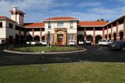
Bunbury High School
Bunbury
South West
Constructed from 1922 to 1923
| Type | Status | Date | Documents |
|---|---|---|---|
| Heritage List | Adopted | 15 Apr 2003 | |
| State Register | Registered | 13 Jul 2012 | HCWebsite.Listing+ListingDocument, HCWebsite.Listing+ListingDocument |
| Type | Status | Date | Documents |
|---|---|---|---|
| (no listings) |
| Type | Status | Date | Grading/Management | |
|---|---|---|---|---|
| Category | ||||
| Municipal Inventory | Adopted | 31 Jul 1996 | Exceptional Significance | |
| Name | Type | Year From | Year To |
|---|---|---|---|
| Ross, Clarence Rose | Architect | - | - |
| Hardwick, W B | Architect | - | - |
| Library Id | Title | Medium | Year Of Publication |
|---|---|---|---|
| 7299 | Bunbury images : people and places. | Book | 2004 |
| 11791 | Bunbury Senior High School Canteen | Archival Record | 2020 |
Individual Building or Group
| Epoch | General | Specific |
|---|---|---|
| Original Use | EDUCATIONAL | Secondary School |
| Present Use | EDUCATIONAL | Secondary School |
| Style |
|---|
| Federation Arts and Crafts |
| Type | General | Specific |
|---|---|---|
| Wall | BRICK | Rendered Brick |
| Wall | STONE | Donnybrook Sandstone |
| Roof | TILE | Terracotta Tile |
| General | Specific |
|---|---|
| SOCIAL & CIVIC ACTIVITIES | Sport, recreation & entertainment |
| SOCIAL & CIVIC ACTIVITIES | Education & science |
This information is provided voluntarily as a public service. The information provided is made available in good faith and is derived from sources believed to be reliable and accurate. However, the information is provided solely on the basis that readers will be responsible for making their own assessment of the matters discussed herein and are advised to verify all relevant representations, statements and information.
Constructed from 1923, Constructed from 1922
Bunbury Senior High School, a two-storey red face brick building in the Inter- War Free Classical style, with rough cast stucco panelling, a hipped terracotta tiled roof and a short tower, comprising original teaching and administration wing (1923), library and classroom additions (1930, 1940), all in a landscaped setting, has cultural heritage significance for the following reasons: the place is one of the oldest surviving government secondary schools in Western Australia, and the finest of three purpose-built high schools erected in major regional centres in 1921-25, having fine design and a magnificent siting; the place is a fine, substantial, and solidly constructed example of the design work of Public Works Department (PWD) architect C. R. Ross, and construction by well known builder Totterdell Bros.; the place demonstrates the high standard of design work by the PWD under Principal Architect W. B. Hardwick; the place is valued for its contribution to the education of a number of Western Australians who have achieved outstanding success in their respective fields; the place, together with the Norfolk Island Pines at the entrance to the site, is a landmark on the outskirts of the central Bunbury area overlooking the city, and is a particularly significant building in the heritage precinct of central Bunbury; the setting of the place, which affords elevated 270 degree water views, is particularly fine for a high school and is unrivalled in Western Australia; and, the ongoing development of the place demonstrates changing approaches to secondary education and the evolution of school design. The Norfolk Island Pines and a large Sheoak at the rear of the girls’ toilet are considered to be of significance.The post-World War II buildings on the site are considered to have little significance.
Bunbury Senior High School, comprising original teaching and administration wing (1923), library and classroom addition (1930) and classroom addition (1940) is a two storey red face brick building with rough cast stucco panelling, a hipped terracotta tiled roof and a short tower. The original teaching and administration wing was designed by C. R. Ross of the Public Works Department under Principal Architect W. B. Hardwick in the Inter-War Free Classical style. The additional wings were constructed in the same style as the original building. The following information is from the Heritage Council of Western Australia's Draft Assessment Documentation: "The site is over 4 ha in size and is bounded by Haig Crescent to the east and south, Russell Esplanade and the Indian Ocean to the west, and residential development to the north. The vehicular entrance to the school is on the eastern corner, and is flanked by four tall mature Norfolk Island pines. An amphitheatre has been constructed into the north facing slope of the hill to the west of this entrance. The driveway leads around a circular planter bed to a bituminised car park in the front courtyard. A number of teaching blocks have been added to the site since 1940. A two storey ‘U’ shaped classroom wing was added to the east in 1960 in a similar scale, form and materials and on the same level as the original building, and forms a courtyard to the south-east of the original building. A single storey medical centre and staff toilet was constructed at the rear of the reception office (originally the girls’ cloakroom) on a 45 degree angle in about 1975, and a transportable classroom building has been located in the centre of the courtyard. At the west (open) end of the courtyard, a large mature Sheoak is a particular feature."
Bunbury Senior High School was built in 1922/23. The high school was initially established in the Bunbury Infants School buildings in 1918 and was the first high school in the district. In the 1890s the only high schools in Western Australia were private schools in the metropolitan area providing classical education for boys and ladylike accomplishments for girls. In 1907, the Inspector General of Education, Cecil Andrews established a system of central schools where upper level classes were added to select government primary schools. This enabled students to study Junior Certificate level classes. There were soon six high schools in the Perth metropolitan area and two in the Goldfields. As the population of Western Australia increased, the need for a workforce with more than elementary education became apparent. There was also a need for students to be properly prepared for university studies. As a result the Perth Modern School was established in 1911 as Western Australia’s first public high school. The need for high schools also reflected the state government’s desire to make secondary education available to all children regardless of class or wealth. Previously, higher education was only available to those who could afford to attend private schools. With the opening of Perth Modern School, secondary education spread rapidly into country areas, but few districts were able to build high schools. The first high school outside of the metropolitan area was the Eastern Goldfields High School in Kalgoorlie, which opened in 1914. In 1918, Northam and Geraldton opened schools which provided three year courses to the standard of the Junior Certificate. Northam was recognised as a full high school in 1921. Also in 1918, Albany and Bunbury schools offered students the opportunity to study at a Junior Certificate level. The Bunbury Senior High School (BSHS) was first established at the original Infants School buildings, on the north east corner of Arthur and Stirling Streets, in 1918. (The Infants School had moved to new buildings across the road.) The BSHS was the first government secondary school in the district and was a great relief to the community as it meant that children did not have to relocate to Perth to finish their education. The school was built on a prominent site on King’s Table (an extensive sand drift later known as Boulter’s Heights) that overlooked the town and ocean. The Government cleared 10 acres of land and the building was commissioned by the principal architect for the Public Works Department, W. N. Hardwick. The building, designed by prominent architect Marshall Clifton, included an assembly hall and was built by the Totterdell Brothers. The original east wing cost £15,189. On 24 February 1922, Sir Hal Colebatch MLC laid the foundation stone and on 9 February 1923, the Premier Sir James Mitchell officially opened the school. The BSHS was built on similar lines to the newly completed high school at Northam and could accommodate 240 students. The ground floor had four classrooms (24’ x 22’), two cloakrooms (22’ x 18’) as well as headmaster’s and teachers’ rooms. The first floor had two laboratories (43’ x 22’ and 36’ x 22’) with adjoining stores and two classrooms (20’ x 22’ and 30’ x 22’). Communication to the classrooms and laboratories was via a 10’ wide colonnade with balcony and staircases at each end. There was also cricket ovals, tennis courts and a gymnasium (60’ x 30’) at the rear of the main building with dressing room and showers attached. Initially shifting sands caused some problems but this was remedied with the planting of gardens. The first mistress at BSHS was Chrystabel (Ghostie) Stephens, who worked there from 1923 to 1940. Stephens taught art and sciences and was responsible for deciding on the girls uniforms. In 1923 Bunbury had an average enrolment of 162 students with an average attendance of 155. The number enrolled at the end of the year was 155. Over the years more buildings have been added to the school, either to accommodate more students or to meet changing educational needs. The Assembly Hall was replaced and the dunes were levelled to make way for playing fields. In 1940, brick classrooms were added to the school by local contractor J. G. Hough at a cost of £4485. At one stage a ship’s bell rescued from an American whaling vessel was used to summon the students to classes. In c.1945 there were 1,500 students enrolled and attached to the school were domestic science classes, including technical education. A purpose built Performing Arts Centre was added in more recent years. By the mid-1940s, buses conveyed students from nearby centres. Country students who attended BSHS were boarded either privately or in hostels run by charitable organisations. In the early years, boys were accommodated at Craig Hostel, which was formerly the Fresh Air League building. When this closed they were moved into a new Craig House in Pickersgill St. The new Craig Hostel accommodated both boys and girls and was run by the Country Women's Association until it closed in 1969. Many girls stayed at the Mary Clementina Girl's Hostel in Spencer Street, where the Sisters of St Elizabeth of Hungary ran the hostel until the early 1950s. Many other students boarded privately. The school is set amongst Norfolk Island Pine trees on an elevated position near Boulters Heights. Due to its central location to the centre of Bunbury and the fact that it is a district high school, the place is seen as a focus for community pride and as a symbol if regional progress.
Several of the school buildings remain intact although some have undergone reconstruction and additions over the years, generally sympathetic to the original style.
Exterior: Good, well-maintained.
| Name | Type | Year From | Year To |
|---|---|---|---|
| Clifton, Marshall | Architect | - | - |
| Reserve | Lot/Location | Plan/Diagram | Vol/Folio |
|---|---|---|---|
| 599 | R 17661 |
This information is provided voluntarily as a public service. The information provided is made available in good faith and is derived from sources believed to be reliable and accurate. However, the information is provided solely on the basis that readers will be responsible for making their own assessment of the matters discussed herein and are advised to verify all relevant representations, statements and information.
9 Halsey St Bunbury
SW Cnr Gregory St
House & Fences
Bunbury
South West
Constructed from 1928
| Type | Status | Date | Documents |
|---|---|---|---|
| Heritage List | Adopted | 15 Apr 2003 |
| Type | Status | Date | Documents |
|---|---|---|---|
| RHP - Assessed - Below Threshold | Current | 13 Nov 1998 |
| Type | Status | Date | Grading/Management | |
|---|---|---|---|---|
| Category | ||||
| Municipal Inventory | Adopted | 31 Jul 1996 | Moderate Significance | |
| Register of the National Estate | Indicative Place | |||
| Classified by the National Trust | Classified | 04 May 1981 | ||
Individual Building or Group
| Epoch | General | Specific |
|---|---|---|
| Present Use | RESIDENTIAL | Single storey residence |
| Original Use | RESIDENTIAL | Single storey residence |
| Style |
|---|
| Federation Arts and Crafts |
| Federation Bungalow |
| Type | General | Specific |
|---|---|---|
| Roof | METAL | Corrugated Iron |
| Wall | BRICK | Rendered Brick |
| General | Specific |
|---|---|
| OTHER | Other Sub-Theme |
This information is provided voluntarily as a public service. The information provided is made available in good faith and is derived from sources believed to be reliable and accurate. However, the information is provided solely on the basis that readers will be responsible for making their own assessment of the matters discussed herein and are advised to verify all relevant representations, statements and information.

Constructed from 1936
House, 9 Halsey Street, a single storey timber and iron house has cultural heritage significance for the following reasons: the place is an example of a residential bungalow constructed in the Inter War period with some Federation Arts and Crafts detailing; the place has landmark qualities and contributes to the streetscape and the community's sense of place.
House, 9 Halsey Street is a single storey timber and iron house constructed in the Inter War period with some Federation arts and Crafts detailing. The walls are timber framed and clad with timber weatherboards to dado height and fibre cement sheeting above. The roof is hipped and gabled and clad with corrugated iron. The gable ends have decorative timber features. The verandah is under a broken back corrugated iron roof supported by timber posts with decorative timber brackets and timber balustrade. The verandah extends around the side of the house to another side entrance door. The front façade has a front door with sidelights with decorative timber framing, flanked on either side by timber windows with decorative timber framing. There are two rendered chimneys evident. The house is situated at street level. There is a modern garage addition at the side of the house. There is a timber picket fence to the front boundary. The pickets to the fence have been replaced and are not the original material or design of the original fence. The entrance gate has a pergola with scalloped detail which is part of the original fence. Again the pickets have been replaced.There is a colourbond/lattice high level fence along part of the front and the side boundary line. It is likely that some decorative features of this house are not original. Previous Description notes: The interior features decorative timber work, influenced by the Arts and Crafts Movement, which also reflects the availability of timber construction materials at that time.
House, 9 Halsey Street was built by Robert W Gregory in 1936. Gregory had bought the land and several nearby lots from Ava Money, a major landowner in the area, in 1928. According to Gregory’s son, Keith, the house was built in 1936. Gregory contracted carpenters to build a timber frame at a cost of £500 and completed the building himself. Gregory also built a painted timber fence across the front of the property using square vertical posts, 1.3 metres in height with rectangular top and bottom rails and alternating plain and decorative (scallop motif) pickets. The centrepiece of the fence was a gateway with a double gate faced with narrow pickets topped by a pergola on eight posts. The fence pickets matched the verandah balustrade. Robert Gregory died in 1956 and title passed to Keith Gregory. Keith undertook extensive alterations to the house and many of the original elements were altered, removed or replaced. The house remained in the Gregory family until 1997. Robert Gregory had lived on the corner of Hasley Street and Minningup Road for many years and the nearby Gregory Street was named after him in 1947. The street was gazetted in 1952. Gregory was also responsible for building the Calvary Wayside Shrine for the Sisters of St Elizabeth of Hungary on the corner of Clarke and Spencer Streets (now located at St Boniface Cathedral). By 2000, a double garage had been built to the side of the house, necessitating removal of part of the fence. It was recorded (2001 MHI) that the remainder of the fence was in deteriorating condition. Many of the pickets were missing while others, including the double gates, were in poor condition. The verandah balustrade had also been removed. By 2010 the entire original fence had been removed. This history is largely based on the Documentary Evidence in Heritage Council of Western Australia, ‘Register Entry: Below Threshold – 9 Halsey Street’, prepared by Natasha Georgiou, 1998.
Medium degree of integrity (original intent partially clear, current use compatible, high long term sustainability). Medium degree of authenticity - alterations but with much original fabric remaining (These statements based on street survey only). Largely remaining in original form and fabric, although verandah posts and facade have been altered and the addition of a modern garage to the western side of the building.
Condition assessed as good (assessed from streetscape survey only).
| Reserve | Lot/Location | Plan/Diagram | Vol/Folio |
|---|---|---|---|
| SL1 | S056008 | VOL2754FOL75 |
This information is provided voluntarily as a public service. The information provided is made available in good faith and is derived from sources believed to be reliable and accurate. However, the information is provided solely on the basis that readers will be responsible for making their own assessment of the matters discussed herein and are advised to verify all relevant representations, statements and information.
Hay Pk, bet Bussell Hwy & Parade Rd Bunbury
Aerodrome
Hay Park Playing Fields
Bunbury
South West
Constructed from 1937
| Type | Status | Date | Documents |
|---|---|---|---|
| (no listings) |
| Type | Status | Date | Documents |
|---|---|---|---|
| (no listings) |
| Type | Status | Date | Grading/Management | |
|---|---|---|---|---|
| Category | ||||
| Municipal Inventory | Adopted | 04 Sep 2001 | ||
| Municipal Inventory | Adopted | 31 Jul 1996 | Historic Site | |
Urban Open Space
| Epoch | General | Specific |
|---|---|---|
| Present Use | SOCIAL\RECREATIONAL | Other |
| Original Use | Transport\Communications | Air: Other |
| General | Specific |
|---|---|
| TRANSPORT & COMMUNICATIONS | Technology & technological change |
| SOCIAL & CIVIC ACTIVITIES | Community services & utilities |
| PEOPLE | Famous & infamous people |
| DEMOGRAPHIC SETTLEMENT & MOBILITY | Technology & technological change |
| TRANSPORT & COMMUNICATIONS | Air transport |
| OCCUPATIONS | Technology & technological change |
| PEOPLE | Innovators |
| SOCIAL & CIVIC ACTIVITIES | Sport, recreation & entertainment |
This information is provided voluntarily as a public service. The information provided is made available in good faith and is derived from sources believed to be reliable and accurate. However, the information is provided solely on the basis that readers will be responsible for making their own assessment of the matters discussed herein and are advised to verify all relevant representations, statements and information.
Constructed from 1937, Constructed from 1960
DEMOLISHED The Original Airstrip was established to provide a landing area for the fledgling aerial services to Bunbury. It is evidence of technological change in transport.
DEMOLISHED
In 1937, an airstrip (aerodome) was built to serve Bunbury and the surrounding district. It opened during the Bunbury Centenary Celebrations. Festivities included an air race between Perth and Bunbury and an aerial pageant. The air race was held on 20 March 1937. Captain Norman Brierley made the first flight to Bunbury in 1920 when he landed his plane at Mill Point. Although it was an airstrip, for many years the ground remained a holding area for livestock. The stock had to be herded out of the flight path on occasions when a small plane was landing. There are no visible remains of the original airstrip, which was essentially a large grassy paddock with a windsock at the main gate.
Site converted to playing fields.
No visible remains.
This information is provided voluntarily as a public service. The information provided is made available in good faith and is derived from sources believed to be reliable and accurate. However, the information is provided solely on the basis that readers will be responsible for making their own assessment of the matters discussed herein and are advised to verify all relevant representations, statements and information.
1 Hayes St Bunbury
Bunbury
South West
Constructed from 1925
| Type | Status | Date | Documents |
|---|---|---|---|
| (no listings) |
| Type | Status | Date | Documents |
|---|---|---|---|
| (no listings) |
| Type | Status | Date | Grading/Management | |
|---|---|---|---|---|
| Category | ||||
| Municipal Inventory | Adopted | 31 Jul 1996 | Some Significance | |
| Municipal Inventory | Adopted | 04 Sep 2001 | ||
Individual Building or Group
| Epoch | General | Specific |
|---|---|---|
| Original Use | RESIDENTIAL | Single storey residence |
| Present Use | RESIDENTIAL | Single storey residence |
| Type | General | Specific |
|---|---|---|
| Wall | ASBESTOS | Fibrous Cement, flat |
| Wall | TIMBER | Other Timber |
| Roof | METAL | Corrugated Iron |
| General | Specific |
|---|---|
| OCCUPATIONS | Domestic activities |
| PEOPLE | Local heroes & battlers |
This information is provided voluntarily as a public service. The information provided is made available in good faith and is derived from sources believed to be reliable and accurate. However, the information is provided solely on the basis that readers will be responsible for making their own assessment of the matters discussed herein and are advised to verify all relevant representations, statements and information.
Constructed from 1925
House, 1 Hayes Street, a single storey timber and iron house has cultural heritage significance for the following reasons: the place has landmark qualities and contributes significantly to the streetscape and the community's sense of place.
House, 1 Hayes Street is a single storey timber and iron house constructed in the Inter-War period. It would appear that the house has been reorientated with the side to the street. The walls are timber framed and clad with timber weatherboards and fibre cement sheeting above the window head line. The roof is hipped and clad with iron. The front door is in an alcove under the main roof (which may have been a rear door). There is a pair of timber double hung sash windows with a fixed pane between at the front of the house (which may have originally been the side). The front verandah has been enclosed with fibre cement sheeting and does not face the street.
The date of construction for House, 1 Hayes Street has not been determined. No entry for the lot could be found in available Bunbury Rate Books prior to 1931. In 1931, House, 1 Hayes Street was owned and occupied by Eric Birch. Mr Birch was still living there in 1941. By 1951, the house was owned by Mrs M Fletcher, who sold it to Minnie Dillon during that year. Both owners lived in the house.
Medium degree of integrity (original intent partially clear, current use compatible, high long term sustainability). Medium degree of authenticity - alterations but with much original fabric remaining (These statements based on street survey only).
Condition assessed as fair (assessed from streetscape survey only).
| Reserve | Lot/Location | Plan/Diagram | Vol/Folio |
|---|---|---|---|
| 21 | P002398 21 |
This information is provided voluntarily as a public service. The information provided is made available in good faith and is derived from sources believed to be reliable and accurate. However, the information is provided solely on the basis that readers will be responsible for making their own assessment of the matters discussed herein and are advised to verify all relevant representations, statements and information.
12 Hayes St Bunbury
Formerly Eileen Street
Bunbury
South West
Constructed from 1910
| Type | Status | Date | Documents |
|---|---|---|---|
| Heritage List | Adopted | 15 Apr 2003 |
| Type | Status | Date | Documents |
|---|---|---|---|
| RHP - To be assessed | Current | 14 Nov 2003 |
| Type | Status | Date | Grading/Management | |
|---|---|---|---|---|
| Category | ||||
| Municipal Inventory | Adopted | 31 Jul 1996 | Moderate Significance | |
05698 Stirling Street Heritage Precinct
Individual Building or Group
| Epoch | General | Specific |
|---|---|---|
| Present Use | RESIDENTIAL | Single storey residence |
| Original Use | RESIDENTIAL | Single storey residence |
| Type | General | Specific |
|---|---|---|
| Wall | TIMBER | Weatherboard |
| Wall | TIMBER | Other Timber |
| Roof | METAL | Corrugated Iron |
This information is provided voluntarily as a public service. The information provided is made available in good faith and is derived from sources believed to be reliable and accurate. However, the information is provided solely on the basis that readers will be responsible for making their own assessment of the matters discussed herein and are advised to verify all relevant representations, statements and information.

Constructed from 1910
House, 12 Hayes Street, a single storey brick and tile house has cultural heritage significance for the following reasons: the place is an example of a bungalow constructed in the Federation period; the place has landmark qualities and contributes significantly to an intact streetscape on the opposite side of the street (including nos 3, 5, 7, 9 and 13 Hayes Street) and the community's sense of place.
House, 12 Hayes Street is a single storey, brick and tile house with an asymmetrical facade designed as an example of the Federation Bungalow style of architecture. The walls are painted brick. The roof is hipped and gabled and clad with tiles. The gable end features a decorative screen with finial and a “small stucco pediment above the main front window. This window currently has an incompatible modern aluminium shade hood. The verandah is under a separate tiled roof and has been enclosed with fibre cement sheeting and security screens. There is a rendered corbelled chimney evident. There is no front fence to this property.
The date of construction for House, 12 Hayes Street has not been determined. No entry could found for the lot in the available Bunbury Rate Books. Hayes Street was originally called Eileen Street. It was renamed to recognise the contribution of the Hayes family to the development of the area. In 1931, many of the lots in the street were owned by the estate of William Hayes, who purchased the land in 1897. In the early twentieth century, many of the residents in East Bunbury were railway and waterside workers.
High degree of integrity (original intent clear, current use compatible, high long term sustainability). High degree of authenticity with much original fabric remaining ( roof material has been replaced). (These statements based on street survey only).
Condition assessed as good (assessed from streetscape survey only).
| Reserve | Lot/Location | Plan/Diagram | Vol/Folio |
|---|---|---|---|
| 2 | D006071 2 |
This information is provided voluntarily as a public service. The information provided is made available in good faith and is derived from sources believed to be reliable and accurate. However, the information is provided solely on the basis that readers will be responsible for making their own assessment of the matters discussed herein and are advised to verify all relevant representations, statements and information.
13 Hayes St Bunbury
Bunbury
South West
Constructed from 1915
| Type | Status | Date | Documents |
|---|---|---|---|
| Heritage List | Adopted | 15 Apr 2003 |
| Type | Status | Date | Documents |
|---|---|---|---|
| RHP - To be assessed | Current | 14 Nov 2003 |
| Type | Status | Date | Grading/Management | |
|---|---|---|---|---|
| Category | ||||
| Municipal Inventory | Adopted | 31 Jul 1996 | Moderate Significance | |
05698 Stirling Street Heritage Precinct
Individual Building or Group
| Epoch | General | Specific |
|---|---|---|
| Present Use | RESIDENTIAL | Single storey residence |
| Original Use | RESIDENTIAL | Single storey residence |
| Style |
|---|
| Inter-War California Bungalow |
| Type | General | Specific |
|---|---|---|
| Wall | TIMBER | Weatherboard |
| Roof | METAL | Corrugated Iron |
| Wall | ASBESTOS | Fibrous Cement, flat |
This information is provided voluntarily as a public service. The information provided is made available in good faith and is derived from sources believed to be reliable and accurate. However, the information is provided solely on the basis that readers will be responsible for making their own assessment of the matters discussed herein and are advised to verify all relevant representations, statements and information.

Constructed from 1915
House, 13 Hayes Street, a single storey timber and iron house has cultural heritage significance for the following reasons: the place is an example of a bungalow constructed in the Federation period; the place has landmark qualities and contributes significantly to an intact streetscape (including nos 3, 5, 7, 9 and 13 Hayes Street) and the community's sense of place.
House, 13 Hayes Street is a single storey timber and iron house constructed in the Federation Bungalow style of architecture. The walls are timber framed and clad with timber weatherboards to dado height and fibre cement sheeting above. The roof is half-gabled hipped and clad with corrugated iron. The verandah is under a continuous corrugated iron roof supported by chamfered timber posts with decorative timber brackets. The symmetrical front façade has a central front door with side and fanlights flanked on either side by windows. A storage area/garage has been added to the western side wall. The house is situated at street level.
The date of construction for House, 13 Hayes Street has not been determined. No entries for the lot could be found in available Bunbury Rate Books prior to 1951. It is thought that House, 13 Hayes Street was built c 1915. By 1951, the house was owned and occupied by Bob Prodgers. The street is named for the Hayes family. In 1931, many of the lots in the street were owned by the estate of William Hayes, who purchased the land in 1897. In the early twentieth century, many of the residents in East Bunbury were railway and waterside workers.
High degree of integrity (original intent clear, current use compatible, high long term sustainability). Medium degree of authenticity - alterations but with much original fabric remaining (These statements based on street survey only).
Condition assessed as good (assessed from streetscape survey only).
| Reserve | Lot/Location | Plan/Diagram | Vol/Folio |
|---|---|---|---|
| 41 | P002398 41 |
This information is provided voluntarily as a public service. The information provided is made available in good faith and is derived from sources believed to be reliable and accurate. However, the information is provided solely on the basis that readers will be responsible for making their own assessment of the matters discussed herein and are advised to verify all relevant representations, statements and information.
3 Hayes St Bunbury
Formerly Eileen Street
Bunbury
South West
Constructed from 1910
| Type | Status | Date | Documents |
|---|---|---|---|
| Heritage List | Adopted | 15 Apr 2003 |
| Type | Status | Date | Documents |
|---|---|---|---|
| RHP - To be assessed | Current | 14 Nov 2003 |
| Type | Status | Date | Grading/Management | |
|---|---|---|---|---|
| Category | ||||
| Municipal Inventory | Adopted | 31 Jul 1996 | Moderate Significance | |
05698 Stirling Street Heritage Precinct
Individual Building or Group
| Epoch | General | Specific |
|---|---|---|
| Present Use | RESIDENTIAL | Single storey residence |
| Original Use | RESIDENTIAL | Single storey residence |
| Style |
|---|
| Federation Bungalow |
| Type | General | Specific |
|---|---|---|
| Wall | TIMBER | Weatherboard |
| Roof | METAL | Corrugated Iron |
This information is provided voluntarily as a public service. The information provided is made available in good faith and is derived from sources believed to be reliable and accurate. However, the information is provided solely on the basis that readers will be responsible for making their own assessment of the matters discussed herein and are advised to verify all relevant representations, statements and information.

Constructed from 1910
House, 3 Hayes Street, a single storey timber and iron house has cultural heritage significance for the following reasons: the place is an example of a bungalow constructed in the Federation period; the place has landmark qualities and contributes significantly to an intact streetscape (including nos 3, 5, 7, 9 and 13 Hayes Street) and the community's sense of place.
House, 3 Hayes Street is a single storey timber and iron house constructed in the Federation period. The walls are timber framed and clad with timber weatherboards. The roof is hipped and clad with corrugated iron. The verandah is under a separate corrugated iron roof supported by timber posts. The symmetrical front façade has a central front door with side and fanlights flanked on either side by French doors which have replaced previous double hung sash windows. The house is situated at street level. There is a carport addition to the western side. A low level rendered masonry wall has been replaced by a masonry pillar and timber picket wall to the front boundary line (see 1978 photo).
The date of construction for House, 3 Hayes Street has not been determined. No entries for the lot could be found in available Bunbury Rate Books prior to 1941. It is thought to have been built c. 1910. In 1941, House, 3 Hayes Street was owned by Pietro Tacheri and occupied by John Hurst. Albert Morris was the owner and occupier in 1951. The street is named for the Hayes family. In 1931, many of the lots in the street were owned by the estate of William Hayes, who purchased the land in 1897. Hayes Street was originally called Eileen Street. In the early twentieth century, many of the residents in East Bunbury were railway and waterside workers.
High degree of integrity (original intent clear, current use compatible, high long term sustainability). Medium to high degree of authenticity - alterations but with much original fabric remaining (These statements based on street survey only).
Condition assessed as good (assessed from streetscape survey only).
| Reserve | Lot/Location | Plan/Diagram | Vol/Folio |
|---|---|---|---|
| 1 | D005176 1 |
This information is provided voluntarily as a public service. The information provided is made available in good faith and is derived from sources believed to be reliable and accurate. However, the information is provided solely on the basis that readers will be responsible for making their own assessment of the matters discussed herein and are advised to verify all relevant representations, statements and information.
5 Hayes St Bunbury
Formerly Eileen Street
Bunbury
South West
Constructed from 1910
| Type | Status | Date | Documents |
|---|---|---|---|
| Heritage List | Adopted | 15 Apr 2003 |
| Type | Status | Date | Documents |
|---|---|---|---|
| RHP - To be assessed | Current | 14 Nov 2003 |
| Type | Status | Date | Grading/Management | |
|---|---|---|---|---|
| Category | ||||
| Municipal Inventory | Adopted | 31 Jul 1996 | Moderate Significance | |
05698 Stirling Street Heritage Precinct
Individual Building or Group
| Epoch | General | Specific |
|---|---|---|
| Present Use | RESIDENTIAL | Single storey residence |
| Original Use | RESIDENTIAL | Single storey residence |
| Style |
|---|
| Federation Carpenter Gothic |
| Type | General | Specific |
|---|---|---|
| Wall | TIMBER | Weatherboard |
| Roof | METAL | Corrugated Iron |
This information is provided voluntarily as a public service. The information provided is made available in good faith and is derived from sources believed to be reliable and accurate. However, the information is provided solely on the basis that readers will be responsible for making their own assessment of the matters discussed herein and are advised to verify all relevant representations, statements and information.

Constructed from 1910
House, 5 Hayes Street, a single storey timber and iron house has cultural heritage significance for the following reasons: the place is an example of a bungalow constructed in the Federation period; the place has landmark qualities and contributes significantly to an intact streetscape (including nos 3, 5, 7, 9 and 13 Hayes Street) and the community's sense of place.
House, 5 Hayes Street is a single storey timber and iron house constructed in the Federation Bungalow style of architecture. The walls are timber framed and clad with timber weatherboards. The roof is hipped and gabled and clad with corrugated iron. The verandah is under a continuous corrugated iron roof supported by timber posts. The asymmetrical front façade has a front door with side and fanlights flanked on one side by a timber framed double hung sash window. The protruding front room has a timber double hung sash window with sidelights and an iron awning supported by decorative timber brackets. There is a rendered corbelled chimney evident. The house is situated at street level. There is a more recently added rendered masonry wall with timber gate on the front boundary line. The adjacent house at No. 7 is an identical house.
The date of construction for House, 5 Hayes Street has not been determined. No entries for the lot could be found in available Bunbury Rate Books prior to 1931. It is thought that House, 5 Hayes Street was built c 1910 and as is of the same design as its neighbour at No 7, it is assumed that they were built at the same time. In 1931, House, 5 Hayes Street was owned and occupied by Reginald Hayes. By 1951, the house was owned and occupied by Albert Baskerville. The street is named for the Hayes family. In 1931, many of the lots in the street were owned by the estate of William Hayes, who purchased the land in 1897. In the early twentieth century, many of the residents in East Bunbury were railway and waterside workers.
High degree of integrity (original intent clear, current use compatible, high long term sustainability). High degree of authenticity with much original fabric remaining. (These statements based on street survey only).
Condition assessed as good (assessed from streetscape survey only).
| Reserve | Lot/Location | Plan/Diagram | Vol/Folio |
|---|---|---|---|
| 2 | D005176 2 |
This information is provided voluntarily as a public service. The information provided is made available in good faith and is derived from sources believed to be reliable and accurate. However, the information is provided solely on the basis that readers will be responsible for making their own assessment of the matters discussed herein and are advised to verify all relevant representations, statements and information.
59 Hayes St Bunbury
Formerly Eileen Street
Bunbury
South West
Constructed from 1900
| Type | Status | Date | Documents |
|---|---|---|---|
| (no listings) |
| Type | Status | Date | Documents |
|---|---|---|---|
| RHP - To be assessed | Current | 14 Nov 2003 |
| Type | Status | Date | Grading/Management | |
|---|---|---|---|---|
| Category | ||||
| Municipal Inventory | Adopted | 31 Jul 1996 | Some Significance | |
05698 Stirling Street Heritage Precinct
Individual Building or Group
| Epoch | General | Specific |
|---|---|---|
| Present Use | RESIDENTIAL | Single storey residence |
| Original Use | RESIDENTIAL | Single storey residence |
| Style |
|---|
| Victorian Georgian |
| Type | General | Specific |
|---|---|---|
| Roof | METAL | Corrugated Iron |
| Wall | TIMBER | Weatherboard |
| General | Specific |
|---|---|
| DEMOGRAPHIC SETTLEMENT & MOBILITY | Settlements |
This information is provided voluntarily as a public service. The information provided is made available in good faith and is derived from sources believed to be reliable and accurate. However, the information is provided solely on the basis that readers will be responsible for making their own assessment of the matters discussed herein and are advised to verify all relevant representations, statements and information.
Constructed from 1900
House, 59 Hayes Street, a single storey timber and iron house has cultural heritage significance for the following reasons: the place is an example of the Victorian Georgian style of architecture; the place has landmark qualities and contributes significantly to the streetscape and the community's sense of place. Notable remnant vegetation in the form of pre-settlement melaluca raphiophylla located on the same block.
House, 59 Hayes Street is a single storey timber and iron house constructed in the Victorian Georgian style of architecture. The walls are timber framed and clad with timber weatherboards and fibre cement sheeting. The roof is hipped and clad with corrugated iron. The verandah is under a separate corrugated iron roof supported by timber posts. The symmetrical front façade has a central front door with modern security screen fitted flanked on either side by timber double hung sash windows with modern security screens fitted. The house is situated at street level. Notable remnant vegetation in the form of pre-settlement melaluca raphiophylla located on the same block.
House, 59 Hayes Street was built c 1900. By 1921, there was house on the lot, owned by William Hayes and occupied by Alex Hayes, a labourer. It is assumed that William and Alex were related. No later entries could be found in available rate books for this lot. There is a mature paperbark tree (Melaleuca raphiophylla) on the site, which is a remnant of the native vegetation in the area prior to European settlement. The street is named for the Hayes family. In 1931, many of the lots in the street were owned by the estate of William Hayes, who purchased the land in 1897.
Tree has been lopped and under planted with tropical plants with no apparent adverse affects. Cottage: High degree of integrity (original intent clear, current use compatible, high long term sustainability). High degree of authenticity with much original fabric remaining. (These statements based on street survey only).
Cottage condition assessed as fair (assessed from streetscape survey only).Tree appears undisturbed and healthy.
| Reserve | Lot/Location | Plan/Diagram | Vol/Folio |
|---|---|---|---|
| 31 | P001825 31 |
This information is provided voluntarily as a public service. The information provided is made available in good faith and is derived from sources believed to be reliable and accurate. However, the information is provided solely on the basis that readers will be responsible for making their own assessment of the matters discussed herein and are advised to verify all relevant representations, statements and information.
7 Hayes St Bunbury
Formerly Eileen Street
Bunbury
South West
Constructed from 1910
| Type | Status | Date | Documents |
|---|---|---|---|
| Heritage List | Adopted | 15 Apr 2003 |
| Type | Status | Date | Documents |
|---|---|---|---|
| RHP - To be assessed | Current | 14 Nov 2003 |
| Type | Status | Date | Grading/Management | |
|---|---|---|---|---|
| Category | ||||
| Municipal Inventory | Adopted | 31 Jul 1996 | Moderate Significance | |
05698 Stirling Street Heritage Precinct
Individual Building or Group
| Epoch | General | Specific |
|---|---|---|
| Original Use | RESIDENTIAL | Single storey residence |
| Present Use | RESIDENTIAL | Single storey residence |
| Style |
|---|
| Federation Bungalow |
| Type | General | Specific |
|---|---|---|
| Roof | METAL | Corrugated Iron |
| Wall | TIMBER | Weatherboard |
This information is provided voluntarily as a public service. The information provided is made available in good faith and is derived from sources believed to be reliable and accurate. However, the information is provided solely on the basis that readers will be responsible for making their own assessment of the matters discussed herein and are advised to verify all relevant representations, statements and information.

Constructed from 1910
House, 7 Hayes Street, a single storey timber and iron house has cultural heritage significance for the following reasons: the place is an example of a bungalow constructed in the Federation period; the place has landmark qualities and contributes significantly to an intact streetscape (including nos 3, 5, 7, 9 and 13 Hayes Street) and the community's sense of place.
House, 7 Hayes Street is a single storey timber and iron house constructed in the Federation Bungalow style of architecture. The walls are timber framed and clad with timber weatherboards. The roof is hipped and gabled and clad with corrugated iron. The verandah is under a continuous corrugated iron roof supported by chamfered timber posts with decorative timber brackets. The asymmetrical front façade has a front door flanked on one side by a timber framed double hung sash window. The protruding front room has a timber double hung sash window with sidelights and an iron awning supported by decorative timber brackets. There is a rendered chimney evident. The house is situated at street level. There is a timber picket fence on the front boundary line. This house is similar to the adjacent No. 5.
The date of construction for House, 7 Hayes Street has not been determined. No entries for the lot could be found in available Bunbury Rate Books prior to 1931. It is thought that House, 7 Hayes Street was built c 1910 and as is of the same design as its neighbor at No 5, it is assumed that they were built at the same time. In 1931, House, 7 Hayes Street was owned by the estate of William Hayes and occupied by James Hughes. In 1951, the house was owned and occupied by P Bunn. The street is named for the Hayes family. In 1931, many of the lots in the street were owned by the estate of William Hayes, who purchased the land in 1897. In the early twentieth century, many of the residents in East Bunbury were railway and waterside workers.
High degree of integrity (original intent clear, current use compatible, high long term sustainability). High degree of authenticity with much original fabric remaining. (These statements based on street survey only).
Condition assessed as good (assessed from streetscape survey only).
| Reserve | Lot/Location | Plan/Diagram | Vol/Folio |
|---|---|---|---|
| 3 | D005176 3 | VOL1903FOL628 |
This information is provided voluntarily as a public service. The information provided is made available in good faith and is derived from sources believed to be reliable and accurate. However, the information is provided solely on the basis that readers will be responsible for making their own assessment of the matters discussed herein and are advised to verify all relevant representations, statements and information.
9 Hayes St Bunbury
Cnr Charles St Formerly Eileen Street
Bunbury
South West
Constructed from 1910
| Type | Status | Date | Documents |
|---|---|---|---|
| Heritage List | Adopted | 15 Apr 2003 |
| Type | Status | Date | Documents |
|---|---|---|---|
| RHP - To be assessed | Current | 14 Nov 2003 |
| Type | Status | Date | Grading/Management | |
|---|---|---|---|---|
| Category | ||||
| Municipal Inventory | Adopted | 31 Jul 1996 | Moderate Significance | |
05698 Stirling Street Heritage Precinct
Individual Building or Group
| Epoch | General | Specific |
|---|---|---|
| Original Use | RESIDENTIAL | Single storey residence |
| Present Use | RESIDENTIAL | Single storey residence |
| Style |
|---|
| Victorian Colonial |
| Type | General | Specific |
|---|---|---|
| Wall | BRICK | Rendered Brick |
| Roof | TILE | Other Tile |
This information is provided voluntarily as a public service. The information provided is made available in good faith and is derived from sources believed to be reliable and accurate. However, the information is provided solely on the basis that readers will be responsible for making their own assessment of the matters discussed herein and are advised to verify all relevant representations, statements and information.

Constructed from 1910
House, 9 Hayes Street,a single storey, rendered masonry and tile house has cultural heritage significance for the following reasons: the place is a good example of the Federation Queen Anne style of architecture; the place has landmark qualities and contributes significantly to an intact streetscape (including nos 3, 5, 7, 9 and 13 Hayes Street) and the community's sense of place.
House, 9 Hayes Street is a single storey, rendered masonry and tile house with an asymmetrical facade designed as an example of the Federation Queen Anne style of architecture. The walls are rendered masonry. The roof is hipped and clad with roof tiles. A semi-octagonal bay typical of the period is evident in the pyramidal roof line. The bay contains double hung sash windows. A later in filled verandah section to the right of the bay has an aluminium framed window. The separate tiled verandah is supported by chamfered timber posts and wraps around the bay. The front door has a fanlight and is flanked on one side by a pair of timber double hung sash windows. There is a rendered corbelled chimney evident.
The date of construction for House, 9 Hayes Street has not been determined. No entries for the lot could be found in available Bunbury Rate Books prior to 1931. In 1931, House, 9 Hayes Street was owned by the estate of William Hayes and occupied by A Rohens. By 1951, the house was owned by Alfred Oates and occupied by W Froome. At some stage, the original iron roof was replaced with tiles. The street is named for the Hayes family. In 1931, many of the lots in the street were owned by the estate of William Hayes, who purchased the land in 1897. Hayes Street was originally called Eileen Street. In the early twentieth century, many of the residents in East Bunbury were railway and waterside workers. At some stage, the original iron roof has been replaced with tiles.
High degree of integrity (original intent clear, current use compatible, high long term sustainability). Medium degree of authenticity - alterations but with much original fabric remaining (These statements based on street survey only).
Condition assessed as good (assessed from streetscape survey only).
| Reserve | Lot/Location | Plan/Diagram | Vol/Folio |
|---|---|---|---|
| 4 | D005176 4 |
This information is provided voluntarily as a public service. The information provided is made available in good faith and is derived from sources believed to be reliable and accurate. However, the information is provided solely on the basis that readers will be responsible for making their own assessment of the matters discussed herein and are advised to verify all relevant representations, statements and information.
Cnr Henry St & The Strand Bunbury
Bunbury
South West
Constructed from 1878 to 1889
| Type | Status | Date | Documents |
|---|---|---|---|
| (no listings) |
| Type | Status | Date | Documents |
|---|---|---|---|
| (no listings) |
| Type | Status | Date | Grading/Management | |
|---|---|---|---|---|
| Category | ||||
| Municipal Inventory | Adopted | 04 Sep 2001 | ||
| Municipal Inventory | Adopted | 31 Jul 1996 | Historic Site | |
Historic Site
| Epoch | General | Specific |
|---|---|---|
| Present Use | VACANT\UNUSED | Vacant\Unused |
| Original Use | INDUSTRIAL\MANUFACTURING | Flour Mill |
| Type | General | Specific |
|---|---|---|
| Wall | BRICK | Common Brick |
This information is provided voluntarily as a public service. The information provided is made available in good faith and is derived from sources believed to be reliable and accurate. However, the information is provided solely on the basis that readers will be responsible for making their own assessment of the matters discussed herein and are advised to verify all relevant representations, statements and information.
Constructed from 1878 to 1889
DEMOLISHED Koombana Flour Mill was established by Robert Forrest and his father William in 1878 and it was both a prominent landmark in the Bunbury town centre and an important part of the local economy. When the Forrests installed a pair of steel rollers in 1889, Koombana was the first mill in Western Australia to have this new machinery.
DEMOLISHED Was a substantial two storey brick building, with high chimneys rising from the roof. The office administration was located in a separate building facing Henry Street.
Koombana Flour Mill was built by Robert Forrest and his father, William, in 1879. It was a substantial two storey brick building, with high chimneys rising from the roof. The office administration was located in a separate building facing Henry Street. William Forrest had substantial experience in milling in the Bunbury district. He had earlier built water flour mills at Mill Point and Picton and after these failed, another at Leschenault. His was more successful, but a fire in September 1867, caused losses valued at £3,000. Forrest rebuilt his mill, which opened for business in 1868. It is presumed that when Robert and William built their mill in town in 1878 that the machinery from the Leschenault Mill was adapted into the new structure. When the Forrests installed a pair of steel rollers in 1889, Koombana was the first mill in Western Australia to have this new machinery. The roller technology was a breakthrough in the industry and was used in conjunction with the traditional millstones, indicating that the ‘half-high’ milling process was likely to have been used. The output from the mill was strictly for the local market which the Forrest family had been serving since 1846. Robert Forrest was manager of the Koombana Flour Mill until his death in November 1924. The mill was then taken over by Ted Properjohn until it closed in 1929.
DEMOLISHED
No visible remains.
This information is provided voluntarily as a public service. The information provided is made available in good faith and is derived from sources believed to be reliable and accurate. However, the information is provided solely on the basis that readers will be responsible for making their own assessment of the matters discussed herein and are advised to verify all relevant representations, statements and information.
61 Hough Rd Bunbury
opp Parade Hotel, behind Hotel Car parking area
Bunbury
South West
Constructed from 1937
| Type | Status | Date | Documents |
|---|---|---|---|
| (no listings) |
| Type | Status | Date | Documents |
|---|---|---|---|
| (no listings) |
| Type | Status | Date | Grading/Management | |
|---|---|---|---|---|
| Category | ||||
| Municipal Inventory | Adopted | 31 Jul 1996 | Historic Site | |
| Municipal Inventory | Adopted | 04 Sep 2001 | ||
| Name | Type | Year From | Year To |
|---|---|---|---|
| E G Cohen | Architect | - | - |
| Library Id | Title | Medium | Year Of Publication |
|---|---|---|---|
| 9935 | Electricity generation, transmission and distribution in Western Australia: representation on the register of heritage places. | Report | 2007 |
Individual Building or Group
| Epoch | General | Specific |
|---|---|---|
| Present Use | VACANT\UNUSED | Vacant\Unused |
| Original Use | RESIDENTIAL | Single storey residence |
| Style |
|---|
| Inter-War California Bungalow |
| Type | General | Specific |
|---|---|---|
| Roof | TILE | Terracotta Tile |
| Wall | TIMBER | Weatherboard |
| Wall | ASBESTOS | Asbestos Tile |
| General | Specific |
|---|---|
| PEOPLE | Famous & infamous people |
This information is provided voluntarily as a public service. The information provided is made available in good faith and is derived from sources believed to be reliable and accurate. However, the information is provided solely on the basis that readers will be responsible for making their own assessment of the matters discussed herein and are advised to verify all relevant representations, statements and information.
Constructed from 1937
DEMOLISHED House, Lot 61 Hough Road was designed by architect Eustace Cohen and built by local contactor, J G Hough. For many years, it was the residence of former Mayor of Bunbury, Percy Payne.
DEMOLISHED
Hough Road was named after James Hough and his family who arrived at Australind in the ‘Parkfield’ in 1841. The Houghs farmed in the district and the family building firm built many of Bunbury’s buildings, including this residence. House, 19 Hough Road (Lot 61) was built c 1937 for Fred Flanagan. The house was designed by architect E G Cohen and built by J G Hough and Son. The property was sold to a Miss Lucas and later to the Payne Family. Percy Payne was Mayor of Bunbury from 1945 to 1951 and again from 1955 to 1958. He had been a local councilor since 1941. Payne has been described as a ‘rambunctious figure in local politics.’ The bungalow was largely in its original form but poor condition when it was demolished in 2001. Eustace Cohen (born London, 1881) was articled to Thomas Lockwood and Sons at Chester before working for Guy Dawber. He emigrated to Western Australia due to ill health in 1904 and set up practice in Bunbury and Busselton (1906-1913). He moved to Perth in 1914, where he formed a partnership with Joseph Eales, trading as Eales and Cohen. Cohen was instrumental in bringing the Arts and Crafts movement to Western Australia. The earliest examples of his work in Bunbury and Busselton display his interpretation of vernacular homes in the Arts and Crafts manner.
DEMOLISHED
DEMOLISHED
This information is provided voluntarily as a public service. The information provided is made available in good faith and is derived from sources believed to be reliable and accurate. However, the information is provided solely on the basis that readers will be responsible for making their own assessment of the matters discussed herein and are advised to verify all relevant representations, statements and information.
Inner Harbour Rd Bunbury
Koombana Bay
Bunbury
South West
Constructed from 1976
| Type | Status | Date | Documents |
|---|---|---|---|
| (no listings) |
| Type | Status | Date | Documents |
|---|---|---|---|
| RHP - Does not warrant assessment | Current | 29 Nov 2019 |
| Type | Status | Date | Grading/Management | |
|---|---|---|---|---|
| Category | ||||
| Municipal Inventory | Adopted | 31 Jul 1996 | ADA - Assess in more detail at DA | |
Historic site
| Epoch | General | Specific |
|---|---|---|
| Original Use | Transport\Communications | Water: Dock\Wharf Bldg or Structure |
| Present Use | Transport\Communications | Water: Dock\Wharf Bldg or Structure |
| Style |
|---|
| Other Style |
| Type | General | Specific |
|---|---|---|
| Other | METAL | Steel |
| General | Specific |
|---|---|
| TRANSPORT & COMMUNICATIONS | River & sea transport |
This information is provided voluntarily as a public service. The information provided is made available in good faith and is derived from sources believed to be reliable and accurate. However, the information is provided solely on the basis that readers will be responsible for making their own assessment of the matters discussed herein and are advised to verify all relevant representations, statements and information.
Constructed from 1976
Dockside woodchip loading facility.
The woodchip loader was built in 1976 at the Bunbury Port Authority as part of the port infrastructure to meet the needs of the new woodchip export industry. In 1969, the Western Australian government passed the Wood Chipping Industry Agreement Act, which committed the State to supplying 500,000 tons of chiplops (subsequently increased to 750,000 tonnes) to the WA Chip and Pulp Co Pty Ltd (WACP) every year for 15 years from the official commencement date. The chips were come from a ‘woodchip licence area’, which covered most of the Southern Forest Region and part of the Central Forest Region. In 1975, Bunnings and Millars commenced production at Diamond Mill, near Manjimup. The first load of woodchips left through the Port of Bunbury for Japan in 1976. By 1979, the yearly tonnage of woodchips leaving through Bunbury was over 562,000. The woodchip industry was not welcomed by everyone and various protest groups formed, including the Campaign to Save Native Forests (SCNF) and the South-West Forests Defence Foundation (SWFDF). They campaigned against environmental damage caused by the industry, breaches of environmental requirements and the large subsidies offered to the woodchipping companies by the State government. On 19 July 1976, the woodchip loader was the target of activists protesting against the industry. The activists bound, gagged and ‘removed’ a security guard then tried to blow up the loader. They had tried to use four boxes of gelignite, each containing 160 sticks, but the gelignite failed to detonate. A second bomb made up of 45kg of explosives was more successful and destroyed part of the conveyor system. Debris from the bomb, weighing up to 20kg each, damaged houses in Austral Parade. Two men were later and charged over the incident. The Western Australian woodchip industry continued to expand and in 2006, figures were up 20% on the previous year, despite a fall nationally. Bunbury and Albany continue to be the main export ports. The woodchip loader is a Port Facility under the Port Authorities Act 1999 and is exempt from the City of Bunbury’s Town Planning Scheme.
Remains largely as constructed in 1976.
Well maintained in good condition.
| Reserve | Lot/Location | Plan/Diagram | Vol/Folio |
|---|---|---|---|
| 25/20 | VCROWNLAND | VOLH101FOL48 |
This information is provided voluntarily as a public service. The information provided is made available in good faith and is derived from sources believed to be reliable and accurate. However, the information is provided solely on the basis that readers will be responsible for making their own assessment of the matters discussed herein and are advised to verify all relevant representations, statements and information.