Local Government
Bunbury
Region
South West
The Strand / Ommanney St Bunbury
Bunbury Outer Harbour nr Casuarina Dv
Co-operative Bulk Handling Silos
Bunbury
South West
Constructed from 1937 to 1961
| Type | Status | Date | Documents |
|---|---|---|---|
| Heritage Agreement | YES | 01 Jul 2002 | HCWebsite.Listing+ListingDocument |
| Heritage List | Adopted | 15 Apr 2003 | |
| State Register | Registered | 28 Jan 2021 | HCWebsite.Listing+ListingDocument, HCWebsite.Listing+ListingDocument |
| Type | Status | Date | Documents |
|---|---|---|---|
| (no listings) |
| Type | Status | Date | Grading/Management | |
|---|---|---|---|---|
| Category | ||||
| Register of the National Estate | Indicative Place | |||
| Classified by the National Trust | Classified | 10 Feb 2003 | ||
| Municipal Inventory | Adopted | 31 Jul 1996 | Exceptional Significance | |
| Library Id | Title | Medium | Year Of Publication |
|---|---|---|---|
| 6342 | Bunbury Harbour City - Marlston Hill development - proposed changes to environmental conditions : report and recommendations of the Environmental Protection Authority. | Report | 1995 |
| 11415 | CBH Grain Transfer Elgee Road, Midland | Archival Record | 2016 |
| 5466 | CBH Silos Bunbury, Western Australia : interpretation plan. | Heritage Study {Other} | 2002 |
| 2400 | Industrial heritage schools competition 1990. | Report | 1990 |
| 873 | Bunbury white (grain ) silos : assessment. | Heritage Study {Other} | 1994 |
| 6341 | Bunbury Harbour City development : Report and recommendations of the Environmental Protection Authority. | Report | 1992 |
| 5465 | CBH Silos, Bunbury, Western Australia : conservation plan. | Heritage Study {Cons'n Plan} | 2002 |
Individual Building or Group
| Epoch | General | Specific |
|---|---|---|
| Present Use | FARMING\PASTORAL | Silo or Grain Shed |
| Original Use | FARMING\PASTORAL | Silo or Grain Shed |
| Style |
|---|
| Other Style |
| Type | General | Specific |
|---|---|---|
| Roof | METAL | Corrugated Iron |
| Wall | CONCRETE | Reinforced Concrete |
| General | Specific |
|---|---|
| OCCUPATIONS | Rural industry & market gardening |
| TRANSPORT & COMMUNICATIONS | Rail & light rail transport |
| DEMOGRAPHIC SETTLEMENT & MOBILITY | Settlements |
This information is provided voluntarily as a public service. The information provided is made available in good faith and is derived from sources believed to be reliable and accurate. However, the information is provided solely on the basis that readers will be responsible for making their own assessment of the matters discussed herein and are advised to verify all relevant representations, statements and information.
Constructed from 2007, Constructed from 1937
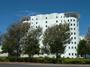
CBH Wheat Silos (fmr) has cultural heritage significance for the following reasons: it is the first advance storage and mechanical bulk grain handling facility constructed in Western Australia; the slip-mould technique of construction was innovative at the time; a dominant structure on the city skyline, the place has strong landmark qualities and contributes to the community's sence of place; the place is representative of Western Australia's bulk grain handling facilities which contribute to the effective exportation of grain, an important facet in the State's economy; and, following the converson of the place to apartments and hotel, the silos received a heritage award from the Heritage Council of Western Australia.
CBH Wheat Silos (fmr) comprises four large cylindrical concrete grain storage silos constructed in 1937 and incorporated into a residential apartment and hotel development in 2007. The four silos are 35ft in diameter, 95ft high and 140ft long. The silo structure is built on reinforced concrete foundations supported by 24ft timber piles bearing onto the underlying basaltic rock. The elevator pit foundations which were adjacent to the southern cell were carried through to the underlying basaltic rock. All grain handling machinery has been removed although photographic recording was carried out prior to removal. The residential apartment and hotel development has incorporated apartments within the cylindrical silo structures with the hotel and other associated functions being located in new adjacent buildings of a rectangular form.
CBH Grain Silos were built in 1937 at a cost of £60,000 and were the first bulk grain handling facility in Western Australia. The silos were the second in the state to use the slip-mould construction technique which was revolutionary for the time. The silos were an important and vital addition to the Bunbury Port. The jetty, built in 1864, (B016.1) resulted in the first stage of growth in the Bunbury area. This was due to a shift from being a district of consumers to producers as the jetty and subsequent harbour developments allowed for the export of produce including grain, wool and timber to other ports in Australia and the world. Consequently, the jetty was extended 11 times between 1864 and 1957 to cope with the increase in shipping as well as to overcome a silting problem. In 1923 Bunbury Harbour was considered to be the principal port of the southern districts. The need for improvements in the bulk handling of grain had been discussed for many years. The Harbours and Rivers branch of the Public Works Department were responsible for the design and construction supervision of the silos. Mr J Stevenson Young was the engineer for the branch. The contract was given to A. T. Brine and Sons who had previously had contracts for the University of Western Australia and other large buildings in Perth. The tender was awarded on the 17 May 1937 and was set to be completed on the 15 December 1937. The building of the four concrete silos was completed over 20 days with work being done 24 hours a day. The silos were coated in white protective paint and had the capacity to hold 8,000 tons of grain. The building of the silos provided employment opportunities for the people of Bunbury who were still feeling the effects of the Great Depression. When the silos had been built machinery was installed which included rail wagon uploading facilities, conveyors, elevators, weighing and discharge equipment. The silos were capable of both bulk discharge into rail wagons for loading onto shipping and bagging facilities for countries that did not have bulk handling facilities. The bulk loading facilities impacted on the lumpers employment as they were no longer needed to handle individual bags of grain. The silos were officially opened by the Acting Premier and Minister for Lands, M. F. Troy, on 28 January 1938. Grain was railed to the silos from around the district, loaded onto wagons and transported to ship loading facilities on the jetty. At the opening Troy commented that ‘there were features connected with the scheme which were rather unique, arising from the fact that storage had to be provided about a mile from the point of discharge into ships.’ The silos were operated by the Bunbury Harbour Board until 1953 when the license for operating them was given to Co-operative Bulk Handling (CBH). Bunbury’s bulk grain facilities were expanded in 1962 with the addition of eight grain silos, which amounted to an extra 18,000 tonnes, being built alongside the original ones. The original silos were referred to as the “white silos” and the new ones as the “grey silos” as they had been left uncoated. In 1969 construction of a new inner harbour commenced. This included improved facilities for bulk handling of woodchips and alumina, which were now being exported through Bunbury. The “white silos” stopped operating in 1985 and by 1991 Bunbury was no longer exporting grain. All of the silos were set for demolition in 1991 but due to public outcry the original silos were retained and the “grey silos” were imploded. There was some debate amongst the public as to what the future use of the silos would be. One proposal from the government was that the silos would form the nucleus of a new $4 million regional museum. Another was that they would be turned into luxury accommodation. The latter option was adopted and the Bunbury City Council gave approval to Kareelya Property Group to develop the area into a mixed-use site combining a resort hotel, conference facilities, residential options including penthouses and apartments, retail outlets, restaurants and an office complex centred around a lively market square. Eventually, the silos were converted into accommodation. Overman and Zuideveld were the Architects for the project. This history is partly based on the Documentary Evidence in Heritage Council of Western Australia, ‘Register of Heritage Places: CBH Silos, Bunbury’, which in turn was based on GB Hill & Partners, 'Bunbury White (Grain) Silos: Assessment', for the Heritage Council of Western Australia, August 1994.
The four silos remain intact although considerable alteration has occurred in the conversion of the place to residential apartments and hotel accommodation.
Condition assessed as good (from streetscape survey only)
| Name | Type | Year From | Year To |
|---|---|---|---|
| Overman and Zuideveld Architects (2007 conversion) | Architect | - | - |
| Reserve | Lot/Location | Plan/Diagram | Vol/Folio |
|---|---|---|---|
| S043451 | VOL2550FOL778 |
This information is provided voluntarily as a public service. The information provided is made available in good faith and is derived from sources believed to be reliable and accurate. However, the information is provided solely on the basis that readers will be responsible for making their own assessment of the matters discussed herein and are advised to verify all relevant representations, statements and information.
40 Tuart St Bunbury
Cnr Stockley Rd
Bunbury
South West
Constructed from 1910
| Type | Status | Date | Documents |
|---|---|---|---|
| Heritage List | Adopted | 15 Apr 2003 |
| Type | Status | Date | Documents |
|---|---|---|---|
| RHP - Assessed - Below Threshold | Current | 26 Jun 1998 |
| Type | Status | Date | Grading/Management | |
|---|---|---|---|---|
| Category | ||||
| Register of the National Estate | Permanent | 18 Apr 1989 | ||
| Classified by the National Trust | Classified | 04 Aug 1980 | ||
| Municipal Inventory | Adopted | 31 Jul 1996 | Considerable Significance | |
Individual Building or Group
| Epoch | General | Specific |
|---|---|---|
| Original Use | RESIDENTIAL | Single storey residence |
| Present Use | RESIDENTIAL | Single storey residence |
| Style |
|---|
| Federation Bungalow |
| Type | General | Specific |
|---|---|---|
| Roof | METAL | Corrugated Iron |
| Wall | TIMBER | Other Timber |
This information is provided voluntarily as a public service. The information provided is made available in good faith and is derived from sources believed to be reliable and accurate. However, the information is provided solely on the basis that readers will be responsible for making their own assessment of the matters discussed herein and are advised to verify all relevant representations, statements and information.

Constructed from 1912
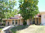
Lilydale, a single-storey timber bungalow has cultural heritage significance for the following reasons: the place is an example of timber worker’s homes built prior to World War One during a period of growth in the local timber construction industry and is one of many such homes in a suburb where the streets are named after trees, illustrating the importance of the timber industry to the Bunbury district; the place demonstrates the adaptation of an earlier rural vernacular form in timber construction and the use of standard timber merchant's components; the building is architecturally significant due to the quality of design from prominent local architect, E.G. Cohen; the place has been associated with the Reading family since 1940; and, the place contributes to the local community’s sense of place as part of a streetscape of timber homes.
Lilydale is a single storey timber and iron house constructed in the Federation Bungalow style of Architecture. The walls are timber framed and clad with timber weatherboards. The roof is hipped and clad with corrugated iron. There is a small feature gable with finial over the front entrance. The verandah is under a separate corrugated iron bullnose roof supported by timber posts with decorative timber brackets at the corners of the house. One end of the verandah is enclosed with timber lattice. The symmetrical front façade has a central front door with decorative security screen with sidelights flanked on either side by timber framed double hung sash windows. There is a brick chimney evident. The house is situated at street level.
The Tree Street area was subdivided in the early 1890s by surveyor W B Mitchell into 95 suburban blocks. The subdivision was called ‘Stirling Townsite’ as the land had originally formed part of Location 26, which was granted to Governor James Stirling in the 1830s. The streets were named Palm, Karri, Banksia, Jarrah, Wattle and Tuart. Lot 48, on which Lilydale is situated, was created in 1892, with the subdivision of approximately fifteen and a half acres (6.35ha) of Location 26 owned by Thomas Hayward and Ephraim Mayo Clarke. Both men were farmers and active in politics. Hayward was MLA for Bunbury from 1901 to 1904, and MLC for Wellington 1904-1911. Clarke was MLC for South Province from 1901 to 1921 and was the Mayor of Bunbury for six years. In 1894 John Bishop, a sawyer, purchased Lot 48 but did not build anything on the land. In 1911 Thomas Prosser Scott, a carter, and later a storeman, purchased the land. The following year he raised a mortgage of £250 to Thomas Smith and had a house built, which was known as “Lilydale.” The house was designed by architect Eustace Cohen and built by local contractor, J G Hough. Cohen and Hough often worked together in Bunbury, producing well-crafted housing using local timber products. Eustace Cohen (born London, 1881) was articled to Thomas Lockwood and Sons at Chester before working for Guy Dawber. He emigrated to Western Australia due to ill health in 1904 and set up practice in Bunbury and Busselton (1906-1913). He moved to Perth in 1914, where he formed a partnership with Joseph Eales, trading as Eales and Cohen. Cohen was instrumental in bringing the Arts and Crafts movement to Western Australia. The earliest examples of his work in Bunbury and Busselton display his interpretation of vernacular homes in the Arts and Crafts manner. Scott lived in the property until 1929, after which time he rented it to a succession of tenants. In 1937, House, 40 Tuart Street was sold to local chemist and photographic supplier, George Cox. Cox also owned Lots 49 and 50 and was thought to have lived in a house at Lot 50. He had purchased these Lots in 1919 and when he purchased Lilydale he lodged an application for a further subdivision which was approved in 1939. This created three different sized lots out of Lots 48, 49 and 50 and reduced the size of Lilydale, now known as Lot 4, from 1012m2 to 678m2. From 1940, House, 40 Tuart Street was rented by Benjamin Walter Reading and his wife Winifred. Reading worked for the Western Australian Government Railways, as did his father Benjamin Thomas Reading. The Readings purchased the house in 1950 and raised a mortgage of £500 with the Mutual Starr Bowkett Society. This was discharged in 1957. Winnifred died in 1986. Benjamin went into a nursing home in 1995 and two years later his daughters inherited the place. Janice Wansbrough bought out her sisters’ share of the property and planned to rent the place out. This history is based on the Documentary Evidence in Heritage Council of Western Australia, ‘Register of Heritage Places Below Threshold documentation: Lilydale’, prepared by Irene Sauman, 1998.
High degree of integrity (original intent clear, current use compatible, high long term sustainability). High degree of authenticity with much original fabric remaining. (These statements based on street survey only).
Condition assessed as good (assessed from streetscape survey only).
| Reserve | Lot/Location | Plan/Diagram | Vol/Folio |
|---|---|---|---|
| 20 | P050821 20 |
This information is provided voluntarily as a public service. The information provided is made available in good faith and is derived from sources believed to be reliable and accurate. However, the information is provided solely on the basis that readers will be responsible for making their own assessment of the matters discussed herein and are advised to verify all relevant representations, statements and information.
42 Tuart St Bunbury
Bunbury
South West
Constructed from 1914
| Type | Status | Date | Documents |
|---|---|---|---|
| Heritage List | Adopted | 15 Apr 2003 |
| Type | Status | Date | Documents |
|---|---|---|---|
| RHP - Does not warrant assessment | Current | 30 Apr 2004 |
| Type | Status | Date | Grading/Management | |
|---|---|---|---|---|
| Category | ||||
| Municipal Inventory | Adopted | 31 Jul 1996 | Considerable Significance | |
| Classified by the National Trust | Classified | 04 Aug 1980 | ||
| Register of the National Estate | Permanent | 18 Apr 1989 | ||
| Name | Type | Year From | Year To |
|---|---|---|---|
| E.G. Cohen | Architect | - | - |
Individual Building or Group
| Epoch | General | Specific |
|---|---|---|
| Original Use | RESIDENTIAL | Single storey residence |
| Present Use | RESIDENTIAL | Single storey residence |
| Style |
|---|
| Federation Arts and Crafts |
| Type | General | Specific |
|---|---|---|
| Wall | TIMBER | Other Timber |
| Roof | METAL | Corrugated Iron |
This information is provided voluntarily as a public service. The information provided is made available in good faith and is derived from sources believed to be reliable and accurate. However, the information is provided solely on the basis that readers will be responsible for making their own assessment of the matters discussed herein and are advised to verify all relevant representations, statements and information.

Constructed from 1925
House, 42 Tuart Street is a single storey timber and iron house has cultural heritage significance for the following reasons: the place is a fine example of the Federation Arts and Crafts style of architecture; the place has landmark qualities and contributes significantly to the streetscape of the tree street area and the community's sense of place; the building is architecturally significant due to the quality of design from prominent local architect, E.G. Cohen.
House, 42 Tuart Street is a single storey timber and iron house constructed in the Federation Arts and Craft style of architecture by the significant architect of the time, Eustace Gresley Cohen. The walls are timber framed and clad with timber weatherboards. The roof is hipped and clad with corrugated iron. The verandah is under a continuous corrugated iron roof supported by turned timber posts. The asymmetrical front façade has a timber window and the protruding front room features a bay window with decorative timber screen under the roof line which is matched to a small gable with finial in the middle of the house. There is a chimney evident. The house is slightly elevated from the street level. There is a limestone pillar and timber picket wall to the front boundary line. Previous descriptive notes state: An early 20th Century fine timber and iron house with highly modelled interiors evident in confident external forms [Molyneux:1978]. The building is one of a coherent group in the vicinity. Some timbers are reputed to have been salvaged from the demolition of a whaling station which previously existed on the shores of Koombana Bay.
The Tree Street area was subdivided in the early 1890s by surveyor W B Mitchell into 95 suburban blocks. The subdivision was called ‘Stirling Townsite’ as the land had originally formed part of Location 26, which was granted to Governor James Stirling in the 1830s. The streets were named Palm, Karri, Banksia, Jarrah, Wattle and Tuart. It is thought that House, 42 Tuart Street was built c 1914/1915 and was designed by architect Eustace Cohen and built by local contractor, J G Hough. Cohen and Hough often worked together in Bunbury, producing well-crafted housing using local timber products. In 1921, the lot was vacant land owned by George Kevin. Eustace Cohen (born London, 1881) was articled to Thomas Lockwood and Sons at Chester before working for Guy Dawber. He emigrated to Western Australia due to ill health in 1904 and set up practice in Bunbury and Busselton (1906-1913). He moved to Perth in 1914, where he formed a partnership with Joseph Eales, trading as Eales and Cohen. Cohen was instrumental in bringing the Arts and Crafts movement to Western Australia. The earliest examples of his work in Bunbury and Busselton display his interpretation of vernacular homes in the Arts and Crafts manner. Between c 1930 and c 1950, the house was owned and occupied by George Shafe Cox. It is believed that some of the timbers were salvaged from the demolition of a whaling station on the shores of Koombana Bay.
High degree of integrity (original intent clear, current use compatible, high long term sustainability). High degree of authenticity with much original fabric remaining. (These statements based on street survey only).
Condition assessed as good (assessed from streetscape survey only).
| Reserve | Lot/Location | Plan/Diagram | Vol/Folio |
|---|---|---|---|
| 11 | P036372 11 | VOL2548FOL854 |
This information is provided voluntarily as a public service. The information provided is made available in good faith and is derived from sources believed to be reliable and accurate. However, the information is provided solely on the basis that readers will be responsible for making their own assessment of the matters discussed herein and are advised to verify all relevant representations, statements and information.
44 Tuart St Bunbury
Bunbury
South West
Constructed from 1910
| Type | Status | Date | Documents |
|---|---|---|---|
| Heritage List | Adopted | 15 Apr 2003 |
| Type | Status | Date | Documents |
|---|---|---|---|
| RHP - Does not warrant assessment | Current | 30 Apr 2004 |
| Type | Status | Date | Grading/Management | |
|---|---|---|---|---|
| Category | ||||
| Classified by the National Trust | Classified | 04 Aug 1980 | ||
| Register of the National Estate | Permanent | 18 Apr 1989 | ||
| Municipal Inventory | Adopted | 31 Jul 1996 | Considerable Significance | |
Individual Building or Group
| Epoch | General | Specific |
|---|---|---|
| Original Use | RESIDENTIAL | Single storey residence |
| Present Use | RESIDENTIAL | Single storey residence |
| Style |
|---|
| Federation Arts and Crafts |
| Type | General | Specific |
|---|---|---|
| Roof | METAL | Corrugated Iron |
| Wall | TIMBER | Weatherboard |
This information is provided voluntarily as a public service. The information provided is made available in good faith and is derived from sources believed to be reliable and accurate. However, the information is provided solely on the basis that readers will be responsible for making their own assessment of the matters discussed herein and are advised to verify all relevant representations, statements and information.

Constructed from 1925
Houes, 44 Tuart Street, a single storey, single room width timber and iron house has cultural heritage significance for the following reasons: the place is a fine example of the Federation Bungalow style of architecture; the place has landmark qualities and contributes significantly to the streetscape of the tree street area and the community's sense of place; the building is architecturally significant due to the quality of design from prominent local architect, E.G. Cohen.
Houes, 44 Tuart Street is a single storey, single room width timber and iron house constructed in the Federation Bungalow style of architecture. The walls are timber framed and clad with timber weatherboards. The roof is hipped and gabled and clad with corrugated iron. The gable end features timber screen and finial. The front door with side and fanlights is recessed with a small separate verandah with corrugated iron roof supported by timber brackets. The asymmetrical front façade has a timber double casement window with a small awning over it. There is a face brick chimney evident. The house is situated at street level. There is a timber picket fence to the front boundary line.
The Tree Street area was subdivided in the 1890s by surveyor W B Mitchell into 95 suburban blocks. The subdivision was called ‘Stirling Townsite’ as the land had originally formed part of Location 26, which was granted to Governor James Stirling in the 1830s. The streets were named Palm, Karri, Banksia, Jarrah, Wattle and Tuart. House, 44 Tuart Street was built c 1925. The exact date of construction has not been determined as no entry could be found for the lot in the 1899 rate book and there are no rate books for the 1906 to 1920 period. In 1921, the lot was vacant land owned by Emily Boor. By 1931, a house has been built on the lot. It was owned and occupied by Hugh Thomas Shaw. It is thought that House, 44 Tuart Street was designed by architect Eustace Cohen and built by local contractor, J G Hough. Cohen and Hough often worked together in Bunbury, producing well-crafted housing using local timber products. Eustace Cohen (born London, 1881) was articled to Thomas Lockwood and Sons at Chester before working for Guy Dawber. He emigrated to Western Australia due to ill health in 1904 and set up practice in Bunbury and Busselton (1906-1913). He moved to Perth in 1914, where he formed a partnership with Joseph Eales, trading as Eales and Cohen. Cohen was instrumental in bringing the Arts and Crafts movement to Western Australia. The earliest examples of his work in Bunbury and Busselton display his interpretation of vernacular homes in the Arts and Crafts manner. By 1951 ownership had changed to Mrs Dorothy E Thomas who also occupied the premises.
High degree of integrity (original intent clear, current use compatible, high long term sustainability). High degree of authenticity with much original fabric remaining. (These statements based on street survey only).
Condition assessed as good (assessed from streetscape survey only).
| Reserve | Lot/Location | Plan/Diagram | Vol/Folio |
|---|---|---|---|
| 1 | D003951 1 | VOL1564FOL535 |
This information is provided voluntarily as a public service. The information provided is made available in good faith and is derived from sources believed to be reliable and accurate. However, the information is provided solely on the basis that readers will be responsible for making their own assessment of the matters discussed herein and are advised to verify all relevant representations, statements and information.
52 Tuart St Bunbury
Bunbury
South West
Constructed from 1900
| Type | Status | Date | Documents |
|---|---|---|---|
| Heritage List | Adopted | 15 Apr 2003 |
| Type | Status | Date | Documents |
|---|---|---|---|
| (no listings) |
| Type | Status | Date | Grading/Management | |
|---|---|---|---|---|
| Category | ||||
| Municipal Inventory | Adopted | 31 Jul 1996 | Moderate Significance | |
Individual Building or Group
| Epoch | General | Specific |
|---|---|---|
| Original Use | RESIDENTIAL | Single storey residence |
| Present Use | RESIDENTIAL | Single storey residence |
| Type | General | Specific |
|---|---|---|
| Roof | METAL | Corrugated Iron |
| Wall | BRICK | Rendered Brick |
This information is provided voluntarily as a public service. The information provided is made available in good faith and is derived from sources believed to be reliable and accurate. However, the information is provided solely on the basis that readers will be responsible for making their own assessment of the matters discussed herein and are advised to verify all relevant representations, statements and information.
Constructed from 1900
House, 52 Tuart Street is a single storey, brick, rendered masonry and iron house with an asymmetrical facade has cultural heritage significance for the following reasons: the place is a fine example of the Federation Queen Anne style of architecture; the place has landmark qualities and contributes significantly to the streetscape of the tree street area and the community's sense of place;
House, 52 Tuart Street is a single storey, brick, rendered masonry and iron house with an asymmetrical facade designed as an example of the Federation Queen Anne style of architecture. The walls are painted brick and rendered masonry. The roof is hipped and clad with corrugated iron. The verandah has a separate corrugated iron bullnose roof and is supported by timber posts with decorative timber brackets. The asymmetrical front façade has a bay window which is expressed in the main roof and verandah roof. There is a rendered chimney with chimney pot evident. There is a brick pillar and timber picket fence to the front boundary line.
The Tree Street area was subdivided in the 1890s by surveyor W B Mitchell into 95 suburban blocks. The subdivision was called ‘Stirling Townsite’ as the land had originally formed part of Location 26, which was granted to Governor James Stirling in the 1830s. The streets were named Palm, Karri, Banksia, Jarrah, Wattle and Tuart. House, 52 Tuart Street was built c 1900. The exact date of construction has not been determined as no entry for the lot could be found in the 1899 Rate Book and there are no rate books for the period 1906 to 1920. In 1921, House, 52 Tuart Street was owned and occupied by B Moriarty. One of the boys who lived in the house was Francis Michael Moriarty, who enlisted with the AIF during World War I. Francis died of wounds received in action on 29 August 1918 and his name is on the Bunbury War Memorial. When Aileen and Blue Mountford visited Francis’ grave in 1992/93, they placed some garden soil from the family home at 52 Tuart Street on the grave. (By 1923, Michael and Susanna Moriarty – Francis’ parents – were living in Armadale.) By 1931, ownership of House, 52 Tuart Street had passed to John W Buckman. John F W Hampel was the owner in 1941, at which time Alex McGibbon was the tenant. By 1951, Hampel was living in the house.
High degree of integrity (original intent clear, current use compatible, high long term sustainability). High degree of authenticity with much original fabric remaining. (These statements based on street survey only). The verandah has been replaced.
Condition assessed as good (assessed from streetscape survey only).
| Reserve | Lot/Location | Plan/Diagram | Vol/Folio |
|---|---|---|---|
| 1 | D000706 1 | VOL1304FOL524 |
This information is provided voluntarily as a public service. The information provided is made available in good faith and is derived from sources believed to be reliable and accurate. However, the information is provided solely on the basis that readers will be responsible for making their own assessment of the matters discussed herein and are advised to verify all relevant representations, statements and information.
59 Tuart St Bunbury
fmr 76 Beach Rd - renumbered after allotment subdivision
Bunbury
South West
Constructed from 1900
| Type | Status | Date | Documents |
|---|---|---|---|
| Heritage List | Adopted | 15 Apr 2003 |
| Type | Status | Date | Documents |
|---|---|---|---|
| (no listings) |
| Type | Status | Date | Grading/Management | |
|---|---|---|---|---|
| Category | ||||
| Municipal Inventory | Adopted | 31 Jul 1996 | Moderate Significance | |
Individual Building or Group
| Epoch | General | Specific |
|---|---|---|
| Original Use | RESIDENTIAL | Single storey residence |
| Present Use | RESIDENTIAL | Single storey residence |
| Type | General | Specific |
|---|---|---|
| Roof | METAL | Corrugated Iron |
| Wall | BRICK | Face Brick |
| General | Specific |
|---|---|
| DEMOGRAPHIC SETTLEMENT & MOBILITY | Land allocation & subdivision |
This information is provided voluntarily as a public service. The information provided is made available in good faith and is derived from sources believed to be reliable and accurate. However, the information is provided solely on the basis that readers will be responsible for making their own assessment of the matters discussed herein and are advised to verify all relevant representations, statements and information.

Constructed from 1900
House, 54 Tuart Street, a single storey brick and tile house has cultural heritage significance for the following reasons: the place is a simple example of the Federation Queen Anne style of architecture; the place contributes significantly to the surrounding Tree Street area streetscape and the community's sense of place.
House, 59 Tuart Street is a single storey, brick and iron house with a symmetrical facade designed as a simple example of the Federation Queen Anne style of architecture. The walls are face brick. The roof is hipped with double gables to the front elevation and clad with corrugated iron. The gable ends feature decorative timber screens. The side gable has an awning underneath it. The verandah has a separate corrugated iron roof, is supported by timber posts, and extends around the side of the house. There are several rendered corbelled chimneys with chimney pots evident. There is a timber picket fence to the front boundary line. Standing roses and vines across the front façade make further description difficult.
The Tree Street area was subdivided in the early 1890s by surveyor W B Mitchell into 95 suburban blocks. The subdivision was called ‘Stirling Townsite’ as the land had originally formed part of Location 26, which was granted to Governor James Stirling in the 1830s. The streets were named Palm, Karri, Banksia, Jarrah, Wattle and Tuart. House, 59 Tuart Street was built c 1900. The exact date of construction has not been determined as no entry for the lot could be found in the 1899 rate book. There are two entries in the 1931 rate book for the lot. One entry was for a house (presumably House, 59 Tuart Street) owned and occupied by Frederick Coles. The other entry was for vacant land owned by Ilina Banting. By 1941, the house was owned by John Bensted of Dardanup and leased by Fred Whitlock. At this time, the house was numbered 9 Tuart Street and there was a second house on the lot. No 7 which was owned and occupied by Ernest Standbury. In 1951, Stanbury still owned No 7 and Mrs Irene Washer King owned No 9 (59 Tuart Street).
High degree of integrity (original intent clear, current use compatible, high long term sustainability). High degree of authenticity with much original fabric remaining. (These statements based on street survey only).
Condition assessed as good (assessed from streetscape survey only).
| Reserve | Lot/Location | Plan/Diagram | Vol/Folio |
|---|---|---|---|
| 6 | D083475 6 | VOL1957FOL698 |
This information is provided voluntarily as a public service. The information provided is made available in good faith and is derived from sources believed to be reliable and accurate. However, the information is provided solely on the basis that readers will be responsible for making their own assessment of the matters discussed herein and are advised to verify all relevant representations, statements and information.
Tuart, Karri ,Spencer, Symonds & Molloy Sts Bunbury
Boulter's Heights
Bunbury
South West
Constructed from 1950
| Type | Status | Date | Documents |
|---|---|---|---|
| (no listings) |
| Type | Status | Date | Documents |
|---|---|---|---|
| (no listings) |
| Type | Status | Date | Grading/Management | |
|---|---|---|---|---|
| Category | ||||
| Municipal Inventory | Adopted | 04 Sep 2001 | ||
| Municipal Inventory | Adopted | Retain & conserve if possible | ||
Historic site
| Epoch | General | Specific |
|---|---|---|
| Original Use | Transport\Communications | Road: Other |
| Present Use | Transport\Communications | Road: Other |
| Type | General | Specific |
|---|---|---|
| Other | CONCRETE | Concrete Slab |
This information is provided voluntarily as a public service. The information provided is made available in good faith and is derived from sources believed to be reliable and accurate. However, the information is provided solely on the basis that readers will be responsible for making their own assessment of the matters discussed herein and are advised to verify all relevant representations, statements and information.
Constructed from 1950
In the 1950s, the Bunbury Council introduced an initiative designed as street signage at the each corner intersection in the town centre. The work was carried out by Council employees and consisted of stylised street names of asphalt letters cast into concrete slabs which form part of the footpath.
In the 1950s, the Bunbury Council introduced an initiative designed as street signage at the each corner intersection in the town centre. It also extended south to the Tree Street area and up to the Highway Hotel. The work was carried out by Council employees and consisted of stylised street names of asphalt letters cast into concrete slabs which form part of the footpath. This technique may have been a response by Council engineering staff to address a need for more permanent street signage as the Bunbury townsite area expanded.
This information is provided voluntarily as a public service. The information provided is made available in good faith and is derived from sources believed to be reliable and accurate. However, the information is provided solely on the basis that readers will be responsible for making their own assessment of the matters discussed herein and are advised to verify all relevant representations, statements and information.
1 Turner St Bunbury
Bunbury
South West
Constructed from 1908 to 1980
| Type | Status | Date | Documents |
|---|---|---|---|
| (no listings) |
| Type | Status | Date | Documents |
|---|---|---|---|
| (no listings) |
| Type | Status | Date | Grading/Management | |
|---|---|---|---|---|
| Category | ||||
| Municipal Inventory | Adopted | 31 Jul 1996 | Historic Site | |
| Register of the National Estate | Permanent | 28 Sep 1982 | ||
| Register of the National Estate | Removed from RNE | 26 Oct 1999 | ||
| Classified by the National Trust | Classified | 26 May 1981 | ||
| Name | Type | Year From | Year To |
|---|---|---|---|
| E.G. Cohen | Architect | - | - |
Individual Building or Group
| Epoch | General | Specific |
|---|---|---|
| Present Use | VACANT\UNUSED | Vacant\Unused |
| Original Use | RESIDENTIAL | Single storey residence |
| Style |
|---|
| Federation Bungalow |
| Type | General | Specific |
|---|---|---|
| Roof | METAL | Corrugated Iron |
| Wall | TIMBER | Other Timber |
This information is provided voluntarily as a public service. The information provided is made available in good faith and is derived from sources believed to be reliable and accurate. However, the information is provided solely on the basis that readers will be responsible for making their own assessment of the matters discussed herein and are advised to verify all relevant representations, statements and information.
The house is of architectural significance and was designed by E G Cohen an influential architect of the period. Compared to the somewhat Tudor vernacular revivalism of No 3 Turner St this house shows the application of vernacular revivalist theory as it began to interpret Australian vernacular forms.
Carrying the same balustrade pattern and other details as No 3 Turner St, also by Cohen. It is now (1980) owned by the medical and health services department as medical officers residence. English vernacular details survive in this house with is however, reminiscent of tropical bungalow forms, an impression reinforced by the palm trees flanking the east elevation. Palm trees are common in houses of this period.
Assessment 1980 Construction: 1908 by E.G> Cohen, built for Mr N Kaesghagen.
This information is provided voluntarily as a public service. The information provided is made available in good faith and is derived from sources believed to be reliable and accurate. However, the information is provided solely on the basis that readers will be responsible for making their own assessment of the matters discussed herein and are advised to verify all relevant representations, statements and information.
Constructed from 1908
DEMOLISHED House, 1 Turner Street was built in 1908 for local businessman, W H Kaeshagen, manager of the Narrogin Trading and Agency Company. It was designed by prominent architect Eustace Cohen and it was a fine and unusual example of his work.
DEMOLISHED
Turner Street is named for local surveyor, G R Turner, who lived in Bunbury in the late 1880s and built the first brick house in the street. House, 1 Turner Street was built in 1908 for local businessman, W H Kaeshagen, manager of the Narrogin Trading and Agency Company. Kaeshagen (b 1878; d 1968) was the founding manager and director of the Narrogin Trading Company. He emigrated from South Australia in 1894 at the beginning of the Gold Boom and established his business in Narrogin, Bunbury and Williams. Kaeshagen lived in Bunbury for 53 years. House, 1 Turner Street was designed by local architect, Eustace Cohen, the house was a fine, single storey timber and iron residence, with a distinctive ‘heart’ cut out pattern on the timber verandah balustrades. Eustace Cohen (born London, 1881) was articled to Thomas Lockwood and Sons at Chester before working for Guy Dawber. He emigrated to Western Australia due to ill health in 1904 and set up practice in Bunbury and Busselton (1906-1913). He moved to Perth in 1914, where he formed a partnership with Joseph Eales, trading as Eales and Cohen. Cohen was instrumental in bringing the Arts and Crafts movement to Western Australia. The earliest examples of his work in Bunbury and Busselton display his interpretation of vernacular homes in the Arts and Crafts manner. At one stage, the house was occupied by the Medical and Health Services Department as a medical officer’s residence. James Grady, initial administrator of the Bunbury Regional Hospital, was a resident at one time. The house was demolished c 1980. One of two large palm trees that framed the house remains at the southern end of the extension to the Senior Citizen’s Building.
DEMOLISHED
DEMOLISHED except for one prominent palm tree (Washingtonia) which is situated in the Car Park of Senior Citizens Centre.
| Name | Type | Year From | Year To |
|---|---|---|---|
| Cohen, Eustace Gresley | Architect | - | - |
| Reserve | Lot/Location | Plan/Diagram | Vol/Folio |
|---|---|---|---|
| 2 | D003236 2 | VOL1637FOL568 |
This information is provided voluntarily as a public service. The information provided is made available in good faith and is derived from sources believed to be reliable and accurate. However, the information is provided solely on the basis that readers will be responsible for making their own assessment of the matters discussed herein and are advised to verify all relevant representations, statements and information.
10 Turner St Bunbury
Bunbury
South West
Constructed from 1880 to 1900
| Type | Status | Date | Documents |
|---|---|---|---|
| Heritage List | Adopted | 15 Apr 2003 | |
| State Register | Registered | 09 May 1997 | HCWebsite.Listing+ListingDocument, HCWebsite.Listing+ListingDocument |
| Type | Status | Date | Documents |
|---|---|---|---|
| (no listings) |
| Type | Status | Date | Grading/Management | |
|---|---|---|---|---|
| Category | ||||
| Municipal Inventory | Adopted | 31 Jul 1996 | Exceptional Significance | |
| Classified by the National Trust | Classified | 04 Aug 1980 | ||
| Register of the National Estate | Permanent | 28 Sep 1982 | ||
Individual Building or Group
| Epoch | General | Specific |
|---|---|---|
| Present Use | RESIDENTIAL | Single storey residence |
| Original Use | RESIDENTIAL | Single storey residence |
| Style |
|---|
| Victorian Italianate |
| Type | General | Specific |
|---|---|---|
| Wall | RENDER | Smooth |
| Roof | METAL | Corrugated Iron |
| Wall | BRICK | Rendered Brick |
| General | Specific |
|---|---|
| DEMOGRAPHIC SETTLEMENT & MOBILITY | Land allocation & subdivision |
| PEOPLE | Famous & infamous people |
This information is provided voluntarily as a public service. The information provided is made available in good faith and is derived from sources believed to be reliable and accurate. However, the information is provided solely on the basis that readers will be responsible for making their own assessment of the matters discussed herein and are advised to verify all relevant representations, statements and information.
Constructed from 1880, Constructed from 1900
House at 10 Turner Street a single-storey brick residence, has cultural heritage significance for the following reasons: it is a picturesque dwelling forming part of the elevated and vegetated townscape backdrop to the City of Bunbury formed by the 'Kings Table' hill; the place demonstrates the turn-of-the-century expansion of the town into its suburbs, following the gradual subdivision of the historic Stirling estate (Location 26), and marking the west boundary of 'Bury Hill' the early Government Resident's property; and as a substantial residential example of the Victorian Italianate style common to the rebuilding of the nearby city centre in the turn-of-the- century gold boom era.
House, 10 Turner Street is a single-storey brick residence designed as an example of the Victorian Italianate style. It comprises a rectangular plan of rooms flanking a central passage with bay-rooms thrust out at front, back and side, enfolding a verandah, with two additional sub-bays flanking the front entrance within the verandah (at the right octagonal, at the left, rectangular). There are projecting bays through the verandah roof to gablets in the main roofs. The rooms flanking the passage are roofed together with a resultant pyramid. An enclosed parapeted skillion extends across the rear. The construction of the main house is of corrugated iron roofing on timber framing, on painted brick walls with stucco decoration, plastered and painted internally, with timber joinery and floors.
Turner Street is named for local surveyor, G R Turner, who lived in Bunbury in the late 1880s and built the first brick house in the street. House, 10 Turner Street was built at some stage between c. 1880 and 1900. ‘ George Tipping, a draper, acquired title to the property in 1911; it was transferred to Edith Elizabeth Tipping in 1915. In the 1920s, House, 10 Turner Street was purchased by John Lewis Prichard, a dentist. It was during his ownership (c 1950) that a conjoined residence was built as a retirement unit. However, Mr Prichard did not like the results and soon sold the property to J W Cross, an earthmoving contractor. Mrs Cross still lived at House, 10 Turner Street in the late 1990s. This history is based on the documentary evidence in Heritage Council of Western Australia, ‘Register of Heritage Places: House 10 Turner Street’, prepared by Ian Molyneux, 1997.
High degree of integrity (original intent clear, current use compatible, high long term sustainability). High degree of authenticity with much original fabric remaining. (These statements based on street survey only).
Condition assessed as good (assessed from streetscape survey only).
| Reserve | Lot/Location | Plan/Diagram | Vol/Folio |
|---|---|---|---|
| 5 | P000803 5 | VOL481VOL147 |
This information is provided voluntarily as a public service. The information provided is made available in good faith and is derived from sources believed to be reliable and accurate. However, the information is provided solely on the basis that readers will be responsible for making their own assessment of the matters discussed herein and are advised to verify all relevant representations, statements and information.
Part of a group of large early 20th century houses and of good architectural quality, but being especially significant to the group in that it illustrates the Italianate stylistic trend which was supplanted by late Victorian English vernacular revivalism illustrated by the other buildings of this group (at 1 & 3 Turner st)
A large rambling bungalow with typical Italianate decoration of the period. This stylistic trend which was introduced from the Eastern states of Australia during the gold boom was one of two major trends evident at the turn of the century in Perth.
Assessment 1980 Construction 1900
This information is provided voluntarily as a public service. The information provided is made available in good faith and is derived from sources believed to be reliable and accurate. However, the information is provided solely on the basis that readers will be responsible for making their own assessment of the matters discussed herein and are advised to verify all relevant representations, statements and information.
3 Turner St Bunbury
Bunbury
South West
Constructed from 1907
| Type | Status | Date | Documents |
|---|---|---|---|
| Heritage List | Adopted | 15 Apr 2003 |
| Type | Status | Date | Documents |
|---|---|---|---|
| RHP - To be assessed | Current | 30 Apr 2004 |
| Type | Status | Date | Grading/Management | |
|---|---|---|---|---|
| Category | ||||
| Municipal Inventory | Adopted | 31 Jul 1996 | Exceptional Significance | |
| Classified by the National Trust | Classified | 04 Aug 1980 | ||
| Register of the National Estate | Permanent | 28 Sep 1982 | ||
• The place has historical value for its association with Mr John Walker a leading solicitor of Bunbury as well as its close associations with a prominent architect Mr Cohen.
The City of Bunbury Municipal Inventory states: Molyneux informs that No 3 Turner Street is a house designed by prominent architect, Eustance Gresley Cohen for Mr John Walker. It illustrates Cohen’s background from the mock Tudor city of Chester and also his England under Guy Dawber (later Sir Guy) who also specialised in sensitive vernacular houses. Mr Walker was solicitor and a significant benefactor to the Anglican Church in Bunbury. In February 1962, the property was auctioned for Mrs Walker. She was Rose Carey, daughter of Surveyor, Thomas Campbell Carey, prior to her marriage to Mr Walker. The house was purchased by Reg Withers (former Senator and Lord Mayor of Perth) and has also been occupied by a community of priests, the Blessed Sacrament Fathers. At one stage, it was home to a woman’s refuge operated by St Vincent de Paul. It is currently occupied as commercial premises providing a unique working environment.’
The City of Bunbury Municipal Inventory states: Molyneux informs that No 3 Turner Street is a house designed by prominent architect, Eustance Gresley Cohen for Mr John Walker. It illustrates Cohen’s background from the mock Tudor city of Chester and also his England under Guy Dawber (later Sir Guy) who also specialised in sensitive vernacular houses. Mr Walker was solicitor and a significant benefactor to the Anglican Church in Bunbury. In February 1962, the property was auctioned for Mrs Walker. She was Rose Carey, daughter of Surveyor, Thomas Campbell Carey, prior to her marriage to Mr Walker. The house was purchased by Reg Withers (former Senator and Lord Mayor of Perth) and has also been occupied by a community of priests, the Blessed Sacrament Fathers. At one stage, it was home to a woman’s refuge operated by St Vincent de Paul. It is currently occupied as commercial premises providing a unique working environment.’
High
Good
| Name | Type | Year From | Year To |
|---|---|---|---|
| E.G. Cohen | Architect | - | - |
Individual Building or Group
| Epoch | General | Specific |
|---|---|---|
| Original Use | RESIDENTIAL | Two storey residence |
| Present Use | RESIDENTIAL | Two storey residence |
| Style |
|---|
| Federation Arts and Crafts |
| Type | General | Specific |
|---|---|---|
| Roof | METAL | Corrugated Iron |
| Wall | TIMBER | Other Timber |
| General | Specific |
|---|---|
| PEOPLE | Famous & infamous people |
This information is provided voluntarily as a public service. The information provided is made available in good faith and is derived from sources believed to be reliable and accurate. However, the information is provided solely on the basis that readers will be responsible for making their own assessment of the matters discussed herein and are advised to verify all relevant representations, statements and information.
Significant as a work of the influential architect, E.G. Cohen, executed soon after his arrival i WA. In the English vernacular revival manner as a work of considerable quality and as part of a group illustrating evolution of styles in WA.
Showing Cohen's background in the Tudor style in the town of Chester, and also his training under Guy Dawber (later Sir Guy), who also specialised in sensitive, vernacular house. This house was owned by Senator Wither's family and is now occupied by a community of priests, the Blesses Sacrament Fathers. Strong Arts & Craft movement evident in details derived from English vernacular sources, soon to be supplanted by Western Australian vernacular influences in the architect's work. A major work by one of the states more prominent architects of the early 20th century.
Assessment 1980 Construction: 1907 Architect: Eustace Gresley Cohen. for Mr John Walker.
This information is provided voluntarily as a public service. The information provided is made available in good faith and is derived from sources believed to be reliable and accurate. However, the information is provided solely on the basis that readers will be responsible for making their own assessment of the matters discussed herein and are advised to verify all relevant representations, statements and information.

Constructed from 1907
House, 3 Turner Street (fmr, a double storey brick, timber and iron house has cultural heritage significance for the following reasons: it was one of the first residences designed by architect Eustace Cohen after his arrival in Western Australia; it was built for John Walker, a prominent Bunbury lawyer, and was later the home of Reg Withers, a politician who had been the Lord Mayor of Perth; the place is a fine example of the Federation Arts and Crafts style of architecture; the place has landmark qualities and contributes significantly to the streetscape and the community's sense of place.
House, 3 Turner Street is a double storey face brick, painted brick, timber and iron house designed in the Federation Arts and Crafts style of architecture.The walls are face and painted brick with some sections timber framed and clad with fibre cement sheeting. The roof is hipped and gabled and clad with corrugated iron. There is a prominant timbered double height balcony with extensive decorative timber detailing. There are large face brick chimneys evident.
Turner Street is named for local surveyor, G R Turner, who lived in Bunbury in the late 1880s and built the first brick house in the street. House, 3 Turner Street was built for John Walker in 1907. Walker was a solicitor and partner in a legal firm, as well as a benefactor to the Anglican Church in Bunbury. He had come to Bunbury in 1896 to marry May Carey, daughter of the surveyor. Walker was a prominent citizen and noted sportsman, particularly horseriding, fishing and sailing. The Church of England Hall built in Oakley Street in 1964 was named Walker Memorial Hall in honour of John Walker. [South Western Times 5 November 1964] The house was designed by local architect Eustace Cohen and reflects Cohen’s background from the mock Tudor city of Chester and his training in England under Guy Dawber (later Sir Guy), who also specialised in sensitive vernacular houses. Eustace Cohen (born London, 1881) was articled to Thomas Lockwood and Sons at Chester before working for Guy Dawber. He emigrated to Western Australia due to ill health in 1904 and set up practice in Bunbury and Busselton (1906-1913). He moved to Perth in 1914, where he formed a partnership with Joseph Eales, trading as Eales and Cohen. Cohen was instrumental in bringing the Arts and Crafts movement to Western Australia. The earliest examples of his work in Bunbury and Busselton display his interpretation of vernacular homes in the Arts and Crafts manner. A photograph dated c 1910 shows the two storey home surrounded by lawn with trees behind. The house was a simplified version of mock Tudor with painted boards under gable roofs to bay windows on the corner room and projecting upper verandah above the entry porch. A first floor verandah extended from the entry porch across the front of the house and under the corner bay window. The verandah had decorative timber infill below the verandah roof, and decorative timber balustrading between the square timber posts, except for the entry porch section, which had painted boards similar to the small upper verandah/porch. The high brick foundation gave the house the appearance of a three storey house. The basement/under house area was accessed by a door (directly under the corner bay window). House, 3 Turner Street remained in the Walker family until 1962, when it was auctioned for Rose Walker, John’s widow. The house was purchased by Reg Withers, a former senator and minister and mayor of Perth, who also served as a councillor on Bunbury Municipal Council. At the time of the auction, the house had a tennis court at the front and was described as ‘built on spacious lines and standing in almost half an acre within sight of the shopping centre.’ The first floor had four bedrooms, a box room, bathroom and sun balcony, while on the ground floor were the lounge, dining and sitting rooms, kitchen, maid’s room and cloak room. Later, House, 3 Turner Street was occupied by the Blessed Sacrament of Fathers, a community of priests. It has also housed a women’s refuge operated by St Vincent de Paul; South West Financial Management; and is now a private home
High degree of integrity (original intent clear, current use compatible, high long term sustainability). Medium degree of authenticity - alterations but with much original fabric remaining (These statements based on street survey only).
Condition assessed as good (assessed from streetscape survey only).
| Reserve | Lot/Location | Plan/Diagram | Vol/Folio |
|---|---|---|---|
| 1 | D002718 1 | VOL1296FOL804 |
This information is provided voluntarily as a public service. The information provided is made available in good faith and is derived from sources believed to be reliable and accurate. However, the information is provided solely on the basis that readers will be responsible for making their own assessment of the matters discussed herein and are advised to verify all relevant representations, statements and information.
6 Turner St Bunbury
Bunbury
South West
Constructed from 1920
| Type | Status | Date | Documents |
|---|---|---|---|
| Heritage List | Adopted | 15 Apr 2003 |
| Type | Status | Date | Documents |
|---|---|---|---|
| (no listings) |
| Type | Status | Date | Grading/Management | |
|---|---|---|---|---|
| Category | ||||
| Municipal Inventory | Adopted | 31 Jul 1996 | High level of protection - TPS | |
| Name | Type | Year From | Year To |
|---|---|---|---|
| E.G. Cohen | Architect | - | - |
Individual Building or Group
| Epoch | General | Specific |
|---|---|---|
| Present Use | RESIDENTIAL | Single storey residence |
| Original Use | RESIDENTIAL | Single storey residence |
| Type | General | Specific |
|---|---|---|
| Roof | METAL | Corrugated Iron |
| Wall | TIMBER | Weatherboard |
This information is provided voluntarily as a public service. The information provided is made available in good faith and is derived from sources believed to be reliable and accurate. However, the information is provided solely on the basis that readers will be responsible for making their own assessment of the matters discussed herein and are advised to verify all relevant representations, statements and information.

Constructed from 1920
House, 6 Turner Street, a timber and iron house, has cultural heritage significance because: it is believed to have been designed by prominent architect, Eustace Cohen, and is an example of a vernacular house in the Arts and Crafts manner.
Attractive timber and iron home with decorative timberwork and brick chimney. An open verandah on slender wooden posts extends along part way along the front and side of the house. A half weatherboard wall which features a bay/bow of timber-framed glazed windows, projects beyond the wall alignment. The dwelling is on elevated land and is visually charming with a wooden lych gate and attractive front and side fencing.
Turner Street is named for local surveyor, G R Turner, who lived in Bunbury in the late 1880s and built the first brick house in the street. House, 6 Turner Street was built c 1920. The exact date of construction has not been determined as no entries for the lot could be found in available Bunbury Rate Books prior to 1931. The house has been attributed to local architect, Eustace Cohen, who operated his business out of Spencer’s Buildings (corner of Victoria and Stephen Street) and an office in Busselton. Eustace Cohen (born London, 1881) was articled to Thomas Lockwood and Sons at Chester before working for Guy Dawber. He emigrated to Western Australia due to ill health in 1904 and set up practice in Bunbury and Busselton (1906-1913). He moved to Perth in 1914, where he formed a partnership with Joseph Eales, trading as Eales and Cohen. Cohen was instrumental in bringing the Arts and Crafts movement to Western Australia. The earliest examples of his work in Bunbury and Busselton display his interpretation of vernacular homes in the Arts and Crafts manner. In 1931, House, 6 Turner Street was owned by Frederick Guy and occupied by Henry Golding. From c. 1940 until at least the early 1950s, the house was owned by Elizabeth Donaldson. It continued to be a rental property during this time. C Malcom and then A J Gardiner were the tenants in 1941. Mrs Dawe lived in the house in 1951 before moving out to make way for the owner, Mrs Donaldson.
High degree of authenticity. The building remains largely in original form.
Exterior: Appears good.
| Name | Type | Year From | Year To |
|---|---|---|---|
| Cohen, Eustace Gresley | Architect | - | - |
| Reserve | Lot/Location | Plan/Diagram | Vol/Folio |
|---|---|---|---|
| 6 | D006714 3 | VOL2013FOL524 |
This information is provided voluntarily as a public service. The information provided is made available in good faith and is derived from sources believed to be reliable and accurate. However, the information is provided solely on the basis that readers will be responsible for making their own assessment of the matters discussed herein and are advised to verify all relevant representations, statements and information.
Upper Esp Bunbury
Bunbury
South West
Constructed from 1842 to 1954
| Type | Status | Date | Documents |
|---|---|---|---|
| (no listings) |
| Type | Status | Date | Documents |
|---|---|---|---|
| (no listings) |
| Type | Status | Date | Grading/Management | |
|---|---|---|---|---|
| Category | ||||
| Municipal Inventory | Adopted | 31 Jul 1996 | Historic Site | |
| Library Id | Title | Medium | Year Of Publication |
|---|---|---|---|
| 5430 | Memorial plaques and historic sites. | Heritage Study {Other} | 1999 |
Historic Site
| Epoch | General | Specific |
|---|---|---|
| Original Use | MONUMENT\CEMETERY | Cemetery |
| Present Use | VACANT\UNUSED | Vacant\Unused |
| General | Specific |
|---|---|
| SOCIAL & CIVIC ACTIVITIES | Community services & utilities |
This information is provided voluntarily as a public service. The information provided is made available in good faith and is derived from sources believed to be reliable and accurate. However, the information is provided solely on the basis that readers will be responsible for making their own assessment of the matters discussed herein and are advised to verify all relevant representations, statements and information.
Constructed from 1842
DEMOLISHED The Original Roman Catholic Cemetery was an important place for the Roman Catholic Diocese from days of early settlement as their place of burial. In 1951 families were given notice to remove all graves and headstones to the new Public Cemetery at their own expense. It is estimated that there are still about 520 graves under the sand dunes.
Public Open Space. It is estimated that there are 520 graves under the sand dunes. There is no visible evidence of the cemetery except for a signpost erected by the Council to mark the site.
Comprising an area of 1 acre 3 perches on Lot 300, Reserve 23888 was surveyed for the purpose of a Roman Catholic Cemetery when Ommaney surveyed the Bunbury Townsite in 1841. On 17 November 1842, Eliza Keegan, a young mother, was the first person to be buried in the Roman Catholic Cemetery. Some 550 Roman Catholic settlers and their descendents were also interred there before the cemetery closed in 1954. The decision to close was partly due to sand movement covering the graves. The land was returned to the Crown in 1951 and some graves were relocated to the new Bunbury Town Cemetery, including nine Sisters of Mercy and Father Dean Martelli. Others were given permission to remove their relatives to the new town cemetery, provided it was at their own expense. The opportunity was beyond the means of many families in the post-War period. The old Catholic Cemetery was graded in 1954 and it is estimated that there are 520 graves under the sand dunes. There is no visible evidence of the graveyard except for a signpost erected by the Council to mark the site. A public Day of Remembrance Mass was held on the site on Monday 6 June 1994 during West Week.
No visible evidence of graveyard exists except for a signpost erected by the Council marking this site.
Public Open Space now covered by sand dunes.
| Reserve | Lot/Location | Plan/Diagram | Vol/Folio |
|---|---|---|---|
| 294 | P159340 294 | VOL1746FOL772 |
This information is provided voluntarily as a public service. The information provided is made available in good faith and is derived from sources believed to be reliable and accurate. However, the information is provided solely on the basis that readers will be responsible for making their own assessment of the matters discussed herein and are advised to verify all relevant representations, statements and information.
4 Upper Esp Bunbury
Bunbury
South West
Constructed from 1920
| Type | Status | Date | Documents |
|---|---|---|---|
| (no listings) |
| Type | Status | Date | Documents |
|---|---|---|---|
| (no listings) |
| Type | Status | Date | Grading/Management | |
|---|---|---|---|---|
| Category | ||||
| Municipal Inventory | Adopted | 31 Jul 1996 | Historic Site | |
Council advised demolition by neglect, unsure of date.
Individual Building or Group
| Epoch | General | Specific |
|---|---|---|
| Original Use | RESIDENTIAL | Two storey residence |
| Present Use | RESIDENTIAL | Two storey residence |
| Type | General | Specific |
|---|---|---|
| Roof | TILE | Terracotta Tile |
| Wall | TIMBER | Weatherboard |
| General | Specific |
|---|---|
| SOCIAL & CIVIC ACTIVITIES | Sport, recreation & entertainment |
This information is provided voluntarily as a public service. The information provided is made available in good faith and is derived from sources believed to be reliable and accurate. However, the information is provided solely on the basis that readers will be responsible for making their own assessment of the matters discussed herein and are advised to verify all relevant representations, statements and information.
Constructed from 1920
DEMOLISHED Esplande Guest House was built in response to Bunbury's growing popularity as a seaside resort in the early 1900s. It was set amongst the sand dunes.
DEMOLISHED
Esplanade Guesthouse was built c 1900 in response to the growing popularity of Bunbury as a seaside resort. The large two-storey timber and tile building had residential accommodation on both levels. There were plenty of wooden floored verandah areas to take in cooling sea breezes and provide extra space for residents. The cut-out decorative balustrades on the verandahs of the original building showed evidence of the work of architect E.G. Cohen, though it is not certain if he designed the premises. At one time, the boarding house was run by Herbert and Jane Webster, who took in workers as well as students from the nearby High School. In August 1983, Ian and Fran Craig established the Calvary Welfare Service Inc and opened the Esplanade Guesthouse as a hostel for the homeless and needy of the area. They also took over Cambridge Villa as a base for the hostel. The place was demolished in 2004.
DEMOLISHED
DEMOLISHED
| Name | Type | Year From | Year To |
|---|---|---|---|
| Cohen, E.G. (not confirmed) | Architect | - | - |
| Reserve | Lot/Location | Plan/Diagram | Vol/Folio |
|---|---|---|---|
| SL1 | S063976 | VOL2844FOL289 |
This information is provided voluntarily as a public service. The information provided is made available in good faith and is derived from sources believed to be reliable and accurate. However, the information is provided solely on the basis that readers will be responsible for making their own assessment of the matters discussed herein and are advised to verify all relevant representations, statements and information.
5 Victoria Bunbury
Lot 10
Bunbury
South West
Constructed from 1903
| Type | Status | Date | Documents |
|---|---|---|---|
| (no listings) |
| Type | Status | Date | Documents |
|---|---|---|---|
| (no listings) |
| Type | Status | Date | Grading/Management | |
|---|---|---|---|---|
| Category | ||||
| (no listings) | ||||
Individual Building or Group
| Epoch | General | Specific |
|---|---|---|
| Present Use | VACANT\UNUSED | Vacant\Unused |
| Original Use | COMMERCIAL | Office or Administration Bldg |
| Style |
|---|
| Federation Romanesque |
| Federation Warehouse |
| Type | General | Specific |
|---|---|---|
| Wall | STONE | Donnybrook Sandstone |
| Roof | METAL | Corrugated Iron |
| General | Specific |
|---|---|
| TRANSPORT & COMMUNICATIONS | River & sea transport |
| DEMOGRAPHIC SETTLEMENT & MOBILITY | Settlements |
This information is provided voluntarily as a public service. The information provided is made available in good faith and is derived from sources believed to be reliable and accurate. However, the information is provided solely on the basis that readers will be responsible for making their own assessment of the matters discussed herein and are advised to verify all relevant representations, statements and information.
This information is provided voluntarily as a public service. The information provided is made available in good faith and is derived from sources believed to be reliable and accurate. However, the information is provided solely on the basis that readers will be responsible for making their own assessment of the matters discussed herein and are advised to verify all relevant representations, statements and information.
NW Cnr Victoria & Stirling Sts Bunbury
NW cnr Stirling St
now the Bunbury Post Office
Bunbury
South West
Constructed from 1870
| Type | Status | Date | Documents |
|---|---|---|---|
| (no listings) |
| Type | Status | Date | Documents |
|---|---|---|---|
| (no listings) |
| Type | Status | Date | Grading/Management | |
|---|---|---|---|---|
| Category | ||||
| Municipal Inventory | Adopted | 31 Jul 1996 | Historic Site | |
| Library Id | Title | Medium | Year Of Publication |
|---|---|---|---|
| 7299 | Bunbury images : people and places. | Book | 2004 |
Historic Site
| Epoch | General | Specific |
|---|---|---|
| Present Use | Transport\Communications | Comms: Post or Telegraph Office |
| Original Use | RESIDENTIAL | Single storey residence |
| Style |
|---|
| Victorian Colonial |
| Type | General | Specific |
|---|---|---|
| Roof | TIMBER | Shingle |
| Wall | TIMBER | Other Timber |
| General | Specific |
|---|---|
| PEOPLE | Famous & infamous people |
This information is provided voluntarily as a public service. The information provided is made available in good faith and is derived from sources believed to be reliable and accurate. However, the information is provided solely on the basis that readers will be responsible for making their own assessment of the matters discussed herein and are advised to verify all relevant representations, statements and information.
Constructed from 1928, Constructed from 1869
DEMOLISHED The Willows was the home of William & Caroline Mitchell and their family. Their son, (Sir) James Mitchell was premier of Western Australia from 1921 to 1924 and again from 1930 to 1933, with the intervening years as opposition leader. He was later Governor of Western Australia. Amy and Kate Mitchell, who lived in the house until the early 1960s, were known for their flower nursery. The Willows was a large and dominating building at the southern end of town.
DEMOLISHED
‘The Willows’ was built in 1869 by G W Floyd for £47/15/8 for the Mitchell family. William Bedford Mitchell was the manager for the Prinsep Estate from 1861 and in 1869, moved his family into Bunbury where he established himself as a stock and land agent. He purchased an acre of land on the western side of Victoria Street, between Stephen Street and Stirling Street, where he had Floyd build his home. William also opened an auction room opposite ‘The Willows’ in January 1902. As a land agent, W B Mitchell produced two maps of consequence to Bunbury – one dated 1863 and the other c 1896 of the Stirling townsite (Tree Street area). His wife, Caroline, was the daughter of John Morgan, who operated hotels at Australind and Bunbury and was associated with the Picton Inn. William and Caroline raised thirteen children in the house. William Mitchell became a local councillor and two of his sons, James and Charles, rose to prominence in Western Australia. Charles D Mitchell joined the Agricultural Bank in 1908 as a full-time field inspector, retiring from a managerial role in 1944. Previous to this he had worked on a surveying team, helped farms with his brothers and had served in the South African War. James Mitchell (born at Dardanup in 1866) was the eldest of the Mitchell children. He joined the West Australian Bank in 1885, was posted to Geraldton and then appointed manager of the Northam branch in 1890. He was a farmer from the early 1920s until his death. In 1905, he won the seat of Northam in the Legislative Assembly. He was Premier of Western Australia from 1921 to 1924 and again from 1930 to 1933, with the intervening years as Opposition leader. James Mitchell was appointed Lieutenant Governor of Western Australia in 1933; the position became Governor in 1948 and he held the post until his death in 1951. Mitchell had a particular interest in agricultural and industrial expansion and was largely responsible for the soldier and group settlement schemes in Western Australia. All family members were noted for their warm and generous hospitatlity, especially Kate and Amy Mitchell who resided at ‘The Willows’ after the death of their parents. The sisters were well known for the flower nursery they conducted from a small detached building on the property. ‘The Willows’ was demolished in 1962 after being continuously occupied by the Mitchell family. At the time of demolition, the Willows was believed to be Bunbury’s oldest dwelling (possibly true for the Bunbury townsite). Circa 1988, a Bicentennial Heritage Trail plaque was attached to the Post Office to commemorate the site of ‘The Willows’ as a tribute to the Mitchell family and as the boyhood home of the Honorable James Mitchell GCMG, a former premier and governor of Western Australia.
DEMOLISHED
No visible remains.
| Reserve | Lot/Location | Plan/Diagram | Vol/Folio |
|---|---|---|---|
| 4 | D072395 4 | VOL1795FOL252 |
This information is provided voluntarily as a public service. The information provided is made available in good faith and is derived from sources believed to be reliable and accurate. However, the information is provided solely on the basis that readers will be responsible for making their own assessment of the matters discussed herein and are advised to verify all relevant representations, statements and information.
Victoria St Bunbury
Approximately near Sportsmarine Store, between Prinsep & Wellington Sts.
Bunbury
South West
Constructed from 1865
| Type | Status | Date | Documents |
|---|---|---|---|
| (no listings) |
| Type | Status | Date | Documents |
|---|---|---|---|
| (no listings) |
| Type | Status | Date | Grading/Management | |
|---|---|---|---|---|
| Category | ||||
| Municipal Inventory | Adopted | 31 Jul 1996 | Historic Site | |
| Municipal Inventory | Adopted | 04 Sep 2001 | ||
Historic Site
| Epoch | General | Specific |
|---|---|---|
| Original Use | COMMERCIAL | Shop\Retail Store {single} |
| Present Use | VACANT\UNUSED | Vacant\Unused |
This information is provided voluntarily as a public service. The information provided is made available in good faith and is derived from sources believed to be reliable and accurate. However, the information is provided solely on the basis that readers will be responsible for making their own assessment of the matters discussed herein and are advised to verify all relevant representations, statements and information.
Constructed from 1865
DEMOLISHED This business was operated by Mary Hay in the main street in the very early days of settlement in Bunbury.
DEMOLISHED.
Mary Hay (nee Hill) established Dundee Store as a grocers and drapers in 1863 soon after her arrival in Australia. The store was named after her home town in Ireland. She traded as Mary Hay & Son, often purchasing local farm produce to sell. At one time, Mary and her son, David, owned Lot 193 through to Lot 197 in Victoria Street, as well as other allotments in the town. David Hill was later rewarded as the discoverer of Collie coal and a reward of £400 was paid to his widow in 1902. David died in 1899. David was a member of the Bunbury Town Trust from 1869 to 1873, from 1874 to 1875 and again from 1881 to 1884. The large warehouse at the rear of the store had a lookout tower, which was used to observe shipping movements. At one stage, the Southern Times newspaper, operated by Henry Eagleton Reading, was printed in the warehouse. By the late 1890s, the property was owned by Ramsay and Forrest, brothers in law to Mary Hay. E Crossley also conducted an ironmongery and plumbing business from Dundee Store at some stage. It is not known when Dundee Store was demolished.
DEMOLISHED.
No visible remains.
| Reserve | Lot/Location | Plan/Diagram | Vol/Folio |
|---|---|---|---|
| 29 | D038386 29 | VOL536FOL78A |
This information is provided voluntarily as a public service. The information provided is made available in good faith and is derived from sources believed to be reliable and accurate. However, the information is provided solely on the basis that readers will be responsible for making their own assessment of the matters discussed herein and are advised to verify all relevant representations, statements and information.
Victoria St Bunbury
Bunbury
South West
Constructed from 1927
| Type | Status | Date | Documents |
|---|---|---|---|
| (no listings) |
| Type | Status | Date | Documents |
|---|---|---|---|
| (no listings) |
| Type | Status | Date | Grading/Management | |
|---|---|---|---|---|
| Category | ||||
| Municipal Inventory | Adopted | 04 Sep 2001 | ||
Historic Site
| Epoch | General | Specific |
|---|---|---|
| Original Use | COMMERCIAL | Shop\Retail Store {single} |
| Present Use | VACANT\UNUSED | Vacant\Unused |
| Type | General | Specific |
|---|---|---|
| Roof | METAL | Corrugated Iron |
| Wall | BRICK | Common Brick |
This information is provided voluntarily as a public service. The information provided is made available in good faith and is derived from sources believed to be reliable and accurate. However, the information is provided solely on the basis that readers will be responsible for making their own assessment of the matters discussed herein and are advised to verify all relevant representations, statements and information.
Constructed from 1927
DEMOLISHED Narrogin Trading and Agency Co was operated by local businessman, Mr W. Kaeshagen who was a founding member of the Bunbury Trader's Association, later to become the Bunbury Chamber of Commerce. His name is commemorated by Kaeshagen Street at Picton.
DEMOLISHED
Established c 1899, Narrogin Trading and Agency Co was a leading merchant trader of a variety of goods with branches in Narrogin, Williams and Bunbury. Narrogin Trading and Agency Co acted as insurance agents, conducted an agency for motor cars and sold farm machinery. The firm is thought to have been founded by Walter Henry Kaeshagen, who walked from South Australia to Coolgardie in 1894 when he was sixteen years old. Kaeshagen was a founding member of both the Bunbury Traders Association (formed c 1920) and its successor, the Bunbury Chamber of Commerce (formed c 1930). W H Kaeshagen is commemorated by Kaeshagen Street in Picton. Narrogin Trading and Agency Co was a brick and iron premises with a roof concealed behind a parapet with a central pediment. The business name was embellished across the pediment and continued below, across the entire width of the building, in large lettering. Narrogin Trading and Agency Co built a service station adjacent to the shop in 1927. The business was still in operation in the 1940s.
N/A
There is no evidence of the site of this business although it is suspected that parts of the original facade or walls may exist.
This information is provided voluntarily as a public service. The information provided is made available in good faith and is derived from sources believed to be reliable and accurate. However, the information is provided solely on the basis that readers will be responsible for making their own assessment of the matters discussed herein and are advised to verify all relevant representations, statements and information.
Victoria St Bunbury
Koombana Court Shop Arcade, Toronto Guest Hse
Koombana House, Duff's Refreshment Rooms
Bunbury
South West
Constructed from 1860 to 1903
| Type | Status | Date | Documents |
|---|---|---|---|
| (no listings) |
| Type | Status | Date | Documents |
|---|---|---|---|
| (no listings) |
| Type | Status | Date | Grading/Management | |
|---|---|---|---|---|
| Category | ||||
| Municipal Inventory | Adopted | 31 Jul 1996 | Historic Site | |
| Library Id | Title | Medium | Year Of Publication |
|---|---|---|---|
| 7299 | Bunbury images : people and places. | Book | 2004 |
Historic Site
| Epoch | General | Specific |
|---|---|---|
| Present Use | COMMERCIAL | Shopping Complex |
| Original Use | RESIDENTIAL | Two storey residence |
| Original Use | Transport\Communications | Comms: Newspaper\Publishing Bldg |
| Type | General | Specific |
|---|---|---|
| Wall | TIMBER | Other Timber |
| Wall | BRICK | Common Brick |
| General | Specific |
|---|---|
| SOCIAL & CIVIC ACTIVITIES | Community services & utilities |
| PEOPLE | Early settlers |
This information is provided voluntarily as a public service. The information provided is made available in good faith and is derived from sources believed to be reliable and accurate. However, the information is provided solely on the basis that readers will be responsible for making their own assessment of the matters discussed herein and are advised to verify all relevant representations, statements and information.
Constructed from 1860
DEMOLISHED Koombana House was constructed by the Scott family, the earliest settlers in the Bunbury district when they moved into town c 1860. It was a popular boarding house for many years and was a prominent landmark in the town.
DEMOLISHED
Circa 1860, John and Helen Scott, the district’s earliest settlers, built a residence and business in Victoria Street. Their son, Robert, and his wife Catherine operated a boarding house from the two storey premises for some years. By 1889, the board and lodging house was owned by Robert Scott. It is believed that most of the boarding house was demolished to make way for a new building c 1903. Several additions and alterations were made to the later building over the years. This later building housed Duff’s Refreshment Rooms and Toronto House and was locally called ‘Koombana House’. It was demolished in August 1987 and the $1.2 Koombana Court Complex built on the site.
DEMOLISHED.
No visible remains.
| Reserve | Lot/Location | Plan/Diagram | Vol/Folio |
|---|---|---|---|
| 16 | D072375 16 | VOL1799FOL992 |
This information is provided voluntarily as a public service. The information provided is made available in good faith and is derived from sources believed to be reliable and accurate. However, the information is provided solely on the basis that readers will be responsible for making their own assessment of the matters discussed herein and are advised to verify all relevant representations, statements and information.
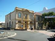
101 Victoria St Bunbury
Cnr Wellington St
Bank of New South Wales(NSW), Lotteries House
Bunbury District Employment Office
Bunbury
South West
Constructed from 1896 to 1992
| Type | Status | Date | Documents |
|---|---|---|---|
| Heritage List | Adopted | 15 Apr 2003 | |
| State Register | Registered | 14 Dec 2001 | HCWebsite.Listing+ListingDocument, HCWebsite.Listing+ListingDocument |
| Type | Status | Date | Documents |
|---|---|---|---|
| (no listings) |
| Type | Status | Date | Grading/Management | |
|---|---|---|---|---|
| Category | ||||
| Municipal Inventory | Adopted | 31 Jul 1996 | Exceptional Significance | |
| Restrictive Covenant | YES | |||
| Classified by the National Trust | Classified | 04 May 1981 | ||
| Register of the National Estate | Permanent | 18 Apr 1989 | ||
| Statewide Bank Survey | Completed | 01 Nov 1997 | ||
| Name | Type | Year From | Year To |
|---|---|---|---|
| Sir Talbot Hobbs | Architect | - | - |
| Library Id | Title | Medium | Year Of Publication |
|---|---|---|---|
| 7241 | Apex House (fmr) and WA bank (fmr) known as Lotteries House, 99-101 Victoria Street, Bunbury : conservation plan. | Heritage Study {Cons'n Plan} | 2005 |
Individual Building or Group
| Epoch | General | Specific |
|---|---|---|
| Original Use | COMMERCIAL | Bank |
| Present Use | GOVERNMENTAL | Office or Administration Bldg |
| Style |
|---|
| Federation Free Classical |
| Type | General | Specific |
|---|---|---|
| Wall | BRICK | Common Brick |
| Wall | RENDER | Cement Dressed |
| General | Specific |
|---|---|
| OCCUPATIONS | Commercial & service industries |
This information is provided voluntarily as a public service. The information provided is made available in good faith and is derived from sources believed to be reliable and accurate. However, the information is provided solely on the basis that readers will be responsible for making their own assessment of the matters discussed herein and are advised to verify all relevant representations, statements and information.
Constructed from 1896
WA Bank (fmr), Bunbury, a two storey brick building with hipped roof in the Federation Free Classical style, has cultural heritage significance for the following reasons: the place is a good example of a substantial two storey bank building designed in the Federation Free Classical style, which together with a number of other substantial buildings dating from the late nineteenth and early twentieth centuries collectively form the significant streetscape that defines the commercial and administrative centre of Bunbury in the vicinity of the intersection of Victoria and Wellington Streets; the place was purpose built in 1896 to accommodate the Bunbury Branch of the Western Australian Bank and, from 1927/1928 to 1962, after the amalgamation of the two banks, was occupied by the Bank of New South Wales; the place was designed by eminent Western Australia soldier and architect Major General Sir John Talbot Hobbs, who was associated with the design of various public and private buildings throughout the State. It displays the principal characteristics of other two storey Western Australian Bank buildings also designed by him in the late nineteenth and early twentieth century; the place is associated with development of Bunbury and the Wellington district at the end of the nineteenth century, which resulted in the consolidation of Bunbury as the principal port and the minor capital of the southwest region; the place is valued by the local and wider community for its contribution to the built environment of Bunbury, and as a result contributes to this community’s sense of place. This is evidenced by its inclusion in all relevant heritage listings; and, the place is valued by the local community for its associations with the various charitable organisations and community groups who have occupied the building from 1989 up to 2001. The single storey rear toilet is assessed as being of little significance.
WA Bank (fmr), Bunbury is a freestanding two storey former bank building of brick and iron construction located at the north-west corner of the intersection of Victoria and Wellington Streets. WA Bank (fmr), Bunbury is a two storey brick building with hipped roof covered with Colorbond finished corrugated steel sheeting. The building is designed in the Federation Academic Classical style c. 1890 to 1915. The front (east) façade of the building is a symmetrical tripartite composition with a slightly projecting central bay with a flanking bay on either side of the central bay. The central bay has full height rendered rustication capped with a rendered pediment. The main entrance is within the central bay housed between layered piers with impost mouldings. The circular arch that contains the glazed fanlight above the door springs from these layered piers. The main entrance has a panelled, three-quarter glazed, double door. The glazed panel of each leaf has four panes. The window at the first floor level of the bay is enclosed within a flat-headed opening and is surrounded by a moulded render architrave with keystone. The window is a timber framed double hung sash. The upper sash is multipaned and the lower is a single pane. There used to be a "juliet" balcony in front of the central window. The flanking bays of the front façade are constructed of tuck pointed brickwork with rendered embellishments. The whole façade has been painted. Each bay is composed of a more solid base upon which sits the upper floor, giving it a lighter, more recessive appearance. The ground floor window is contained between layered pilasters that step back to make a recessed panel below the sill. Set within this panel is a raised panel. The impost moulding of the round arched window opening continues across the facade to line through with the transom of the windows and the main door to form a type of stringcourse. The upper panel of the bay is composed with ionic pilasters set at both of its edges to frame a recessed panel into which is set a single window. The pilasters support an entablature that has a balustrade parapet. The lower windows within these flanking bays consist of four casements set within a timber frame. A substantial moulded timber transom and a turned timber mullion divide the frame into its four parts. The upper windows are set within flat-headed openings with rendered architraves and windows that match the upper window of the central bay. The wall of the south façade of the building is predominantly of tuck pointed brickwork. However the brickwork of the upper rear section, which appears to be a later addition, has cut and struck pointing. The decoration is restricted to the rendered plinth that has a moulded top and a plain rendered stringcourse at first floor level. The parapet of the front façade is buttressed by a return that is about two metres long on the east face of the building, curving down from parapet level to wall plate level. The south façade is simply composed with windows set in walls and their spacing determined by the layout of the rooms behind. The windows on the upper floor are directly above the door and windows on the ground floor. The only exception is at the upper level towards the east end of the wall where there is evidence that the upper level window has been bricked-in. An entrance doorway is located towards the back half of the facade. The opening has a circular arched head. The timber door is three panelled with a glazed upper panel and two lower solid panels. The door is flanked by half glazed sidelights and is topped by a glazed fan light that has been divided into three. The windows at ground floor level are set within circular-arched openings whereas the first floor openings are segmental arched. All have rendered keystones. All windows are timber framed double hung sash type. The rear (west) façade is of the same construction as the south face of the building. A lean-to verandah runs for the length of the façade. The verandah joins the single storey toilet block at the north end and terminates as an arched opening at the south end. The verandah is supported on timber posts with fretwork brackets. The three upper level windows of the rear match those on the east face. The doors and windows at ground floor level are within segmental arched openings. The north face of the building is about one metre from the south wall of 99 Victoria Street. The façade matches the south except that there are no door or window openings within it. The front door is located centrally in the Victoria Street façade and leads into the original banking chamber. This description is based on the Register of Heritage Places assessment documentation prepared by Kris Bizzaca and Alan Kelsall for the Heritage Council of Western Australia, 2001.
The Western Australian Bank was formed by a committee of prominent citizens and businessmen in Perth in 1841. The bank’s first branch was opened in a former store building in Bunbury in May 1878. In 1882, the Bunbury branch moved to the corner of Victoria and Wellington Streets in buildings purchased from Mr Bibra for £1,200. It was here that the bank later built its own premises. In May 1895, architect J J Talbot Hobbs called for tenders on behalf of the Western Australian Bank for the construction of a new bank building. The contract was awarded to J G Baldock and Co at an approximate cost of £1,800. Building commenced in June 1895 and was to be completed by the end of December. Hobbs travelled to Bunbury several times during the build to inspect the work. The new building comprised banking facilities on the ground floor and accommodation for the bank manager and his family on the first floor. Local history has it that James Mitchell, who was to become premier and then governor of Western Australia, was a staff member of the Bunbury branch of the Western Australian Bank at some stage. However, the entry for Sir James in the Australian Dictionary of Biography says that he was posted to Geraldton when he joined the Bank in 1888 and was later manager at Northam. Further research is required to determine whether he worked for any time at the Bunbury branch. Talbot Hobbs supervised alterations and repairs to the building in January 1897. As part of a major shakeup of the banking industry following World War I, in 1927/28 the Western Australian Bank merged with the Bank of New South Wales. Formal ownership of the Bunbury branch of the WA Bank was transferred to the Bank of NSW on 23 April 1928. From this time until the early 1960s, the Bunbury branch of the Bank of NSW operated from 101 Victoria Street. The Bank of NSW decided to build new premises in Bunbury and in late 1962, the Bunbury branch moved to a new building in Victoria Street. The new bank was designed by the architectural firm of Forbes and Fitzhardinge. Ownership of their building at 101 Victoria Street was transferred to the Commonwealth Bank of Australia and from this time until c. 1989, the building was used by the Bunbury District Employment Office. In November 1988, ownership of the building was transferred to the Lotteries Commission and the former bank building at 101 Victoria Street, together with the office building next door at 99 Victoria Street, became known as Lotteries House. The main offices of various charitable organisations and community groups share accommodation at Lotteries House, including the Bunbury Christian Education Council, the Bunbury Community Legal Centre, the Bunbury Youth Accommodation Service and Pregnancy Help. The groups have their own offices but share tea and bathroom facilities and counselling rooms. Extensive renovations were completed in 1992. The Bunbury Community Group acquired ownership of 99-101 Victoria Street in January 1994. At this time, the group was one of those occupying the building. It continued to lease space to various charitable organisations. At some stage, a first floor area was added to the rear of the building at 101 Victoria Street, two kitchens were installed and a single toilet block built. In 2009, Western Australia Bank (fmr) and Solicitor’s Office (fmr) continue to accommodate a variety of community organisation including the Bunbury Housing Association; Volunteers South West; Bunbury Community Legal Centre; Association for the Blind; Bunbury Community Group Inc; Bunbury Migrant Resource Centre; Conservation Volunteers Australia and South West Emergency Care. This history is partly based on the Register of Heritage Places assessment documentation prepared by Kris Bizzaca and Alan Kelsall for the Heritage Council of Western Australia, 2001.
High degree of integrity (original intent clear, current use compatible, high long term sustainability). High degree of authenticity - minor alterations but with much original fabric remaining (These statements based on street survey only).
Condition assessed as good (assessed from streetscape survey only).
| Reserve | Lot/Location | Plan/Diagram | Vol/Folio |
|---|---|---|---|
| 1 | D007885 1 | VOL1000FOL53 |
This information is provided voluntarily as a public service. The information provided is made available in good faith and is derived from sources believed to be reliable and accurate. However, the information is provided solely on the basis that readers will be responsible for making their own assessment of the matters discussed herein and are advised to verify all relevant representations, statements and information.
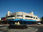
103-107 Victoria St Bunbury
Cnr Wellington St
Smith's Buildings
Smith's Drapery
Bunbury
South West
Constructed from 1938
| Type | Status | Date | Documents |
|---|---|---|---|
| Heritage List | Adopted | 15 Apr 2003 | |
| State Register | Registered | 07 Feb 1997 | HCWebsite.Listing+ListingDocument, HCWebsite.Listing+ListingDocument |
| Type | Status | Date | Documents |
|---|---|---|---|
| (no listings) |
| Type | Status | Date | Grading/Management | |
|---|---|---|---|---|
| Category | ||||
| Art Deco Significant Bldg Survey | Completed | |||
| Register of the National Estate | Interim | 26 Apr 1988 | ||
| Register of the National Estate | Registered | 15 May 1990 | ||
| Classified by the National Trust | Classified | 04 May 1981 | ||
| Municipal Inventory | Adopted | 31 Jul 1996 | Exceptional Significance | |
| Name | Type | Year From | Year To |
|---|---|---|---|
| O.V. Chisholm. | Architect | - | - |
| Library Id | Title | Medium | Year Of Publication |
|---|
Individual Building or Group
| Epoch | General | Specific |
|---|---|---|
| Original Use | COMMERCIAL | Shop\Retail Store {single} |
| Present Use | COMMERCIAL | Shop\Retail Store {single} |
| Style |
|---|
| Inter-War Functionalist |
| Type | General | Specific |
|---|---|---|
| Wall | BRICK | Painted Brick |
| Wall | BRICK | Rendered Brick |
| Roof | ASBESTOS | Fibrous Cement, corrugated |
| General | Specific |
|---|---|
| OCCUPATIONS | Commercial & service industries |
| OUTSIDE INFLUENCES | Depression & boom |
This information is provided voluntarily as a public service. The information provided is made available in good faith and is derived from sources believed to be reliable and accurate. However, the information is provided solely on the basis that readers will be responsible for making their own assessment of the matters discussed herein and are advised to verify all relevant representations, statements and information.
Constructed from 1937
Cronshaw's Manchester House, a two-storey Inter-War Functionalist style structure (with some Art Deco style detailing), of rendered and painted brick with an asbestos cement roof, has cultural heritage significance for the following reasons: it demonstrates the confidence and surety of the abstract aesthetic ideals of the Modern Movement; it contributes to the aesthetic value of the intersection of Victoria and Wellington streets as a landmark within a notable, well articulated and focused urban space, and as a major component in the wider, picturesque precinct of which the intersection is a part; it illustrates the evolution of architecture, of the commercial retailing, residential flat and shop-dwelling classes of buildings in Bunbury; it serves as a benchmark for evaluation and understanding of its architectural style and building type; and, it has social value as a significant town centre precinct and as a gathering place that contributes to a sense of place and social cohesion.
Cronshaw's Manchester House is a white painted rendered brick two storey retail store with an asbestos cement roof located on a prominent corner of the town designed in the inter war Functionalist style of the 1930s. It includes an asbestos cement roof, red fair-face clay brickwork walls in the utilitarian rear internal elevations, painted cement rendered walls to the street elevations, recessed balconies with projecting painted and rendered concrete balcony floors and balustrades, incised string courses in the wall planes, steel windows with horizontally proportioned panes and cantilevered concrete sun hoods, and a sheet and pressed-metal clad and lined, cantilevered street canopy, suspended by steel rods.
The store at 103-107 Victoria Street was built in 1937 for William Smith, a manchester retailer. The building was designed by Ossie Chisholm of the prominent Perth architectural firm, Powell Cameron and Chisholm. It was constructed at a cost of £8,600 by Perth based contractors, D A Dodds. The building soon became known as ‘Smith’s Buildings’, which was also written on signage on the building. The building featured a ground floor drapery shop facing the corner; flats on the first floor providing inner city living, with the entrance from Victoria Street; a pair of smaller speciality shops facing Wellington Street; and, a cantilevered street canopy extending across all street facades. In 1966, James Bowen Cronshaw purchased the building for £36,000 and moved the family business into Smith’s Buildings. James’ father, James ‘Jim’, established ‘Manchester House’ in Perth in 1920, with branches in Bunbury and Collie the following year. His first Bunbury store opened on 30 May 1920 and was located at the current site of Wight and Emmett on Wellington Street. Cronshaw’s Manchester House then moved to Victoria Street. Later, the business moved to another site in Victoria Street. When Jim Cronshaw retired in 1946, James took over the business. In 1955, a new store was built on Lot 207 Victoria Street, next to the Rose Hotel. It was built by J M Best at a cost of £4,884. By the late 1960s, Cronshaws also had another business in Bunbury – Cronshaw’s House of Gifts in Austral Chambers in Stephen Street. Those premises were later sold to the Home Building Society. James Cronshaw also leased a men’s store on the corner of Prinsep Street and Victoria Street for a time. By 1997, Cronshaw’s businesses were confined to the former Smith’s Building (retail shop) and the 1955 building next to the Rose Hotel (business headquarters). By this time, the two small speciality shops facing Wellington Street had been amalgamated and extended at the rear to take up the rear yard of the site. The shops have also been combined with the main corner shop by a roofed delivery bay behind the original connecting facade. The first floor flats are no longer used for accommodation. They are now used as storage and work areas (although the deterioration of the asbestos roof and ceilings currently limits this use). This history is based on Heritage Council of Western Australia, ‘Register of Heritage Places: Cronshaw’s Store’, prepared by Ian Molyneux, 1997.
High degree of integrity (original intent clear, current use compatible, high long term sustainability). High degree of authenticity with much original fabric remaining. (These statements based on street survey only).
Condition assessed as Fair (assessed from streetscape survey only).
| Reserve | Lot/Location | Plan/Diagram | Vol/Folio |
|---|---|---|---|
| 194 | P222212 194 | VOL599FOL28A |
This information is provided voluntarily as a public service. The information provided is made available in good faith and is derived from sources believed to be reliable and accurate. However, the information is provided solely on the basis that readers will be responsible for making their own assessment of the matters discussed herein and are advised to verify all relevant representations, statements and information.