Local Government
Vincent
Region
Metropolitan
15 Wasley St Mount Lawley
Vincent
Metropolitan
| Type | Status | Date | Documents |
|---|---|---|---|
| Heritage List | Adopted | 12 Sep 2006 |
| Type | Status | Date | Documents |
|---|---|---|---|
| (no listings) |
| Type | Status | Date | Grading/Management | |
|---|---|---|---|---|
| Category | ||||
| Municipal Inventory | Adopted | 12 Sep 2006 | Category B | |
Individual Building or Group
This information is provided voluntarily as a public service. The information provided is made available in good faith and is derived from sources believed to be reliable and accurate. However, the information is provided solely on the basis that readers will be responsible for making their own assessment of the matters discussed herein and are advised to verify all relevant representations, statements and information.
| Reserve | Lot/Location | Plan/Diagram | Vol/Folio |
|---|---|---|---|
| Lot 245 | 2355 |
This information is provided voluntarily as a public service. The information provided is made available in good faith and is derived from sources believed to be reliable and accurate. However, the information is provided solely on the basis that readers will be responsible for making their own assessment of the matters discussed herein and are advised to verify all relevant representations, statements and information.
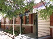
35 Wasley St Mount Lawley
Vincent
Metropolitan
Constructed from 1950, Constructed from 1898
| Type | Status | Date | Documents |
|---|---|---|---|
| Heritage List | Adopted |
| Type | Status | Date | Documents |
|---|---|---|---|
| (no listings) |
| Type | Status | Date | Grading/Management | |
|---|---|---|---|---|
| Category | ||||
| Municipal Inventory | Adopted | 22 Dec 1997 | Category B | |
Individual Building or Group
| Epoch | General | Specific |
|---|---|---|
| Present Use | RESIDENTIAL | Single storey residence |
| Original Use | RESIDENTIAL | Single storey residence |
| Type | General | Specific |
|---|---|---|
| Other | TIMBER | Other Timber |
| Roof | METAL | Corrugated Iron |
| Wall | BRICK | Face Brick |
| Wall | BRICK | Painted Brick |
| General | Specific |
|---|---|
| DEMOGRAPHIC SETTLEMENT & MOBILITY | Settlements |
This information is provided voluntarily as a public service. The information provided is made available in good faith and is derived from sources believed to be reliable and accurate. However, the information is provided solely on the basis that readers will be responsible for making their own assessment of the matters discussed herein and are advised to verify all relevant representations, statements and information.
Constructed from 1898 to 1905
The house at No 35 is a good and intact example of a Federation Georgian bungalow, closely derived from Late Colonial precedents.
The house is closely modelled on Late Colonial Georgian precedents. It varies from these precedents in the decorative treatment of its front façade. It has a symmetrical plan form, a hipped roof and was originally face brick on all visible facades. It has clipped eaves, a separate bullnose verandah supported on turned posts and bracketed and spindled valences. The central door is flanked by double hung sash windows. The former face brickwork of the façade has been painted and the banding/dado has been disguised. In the 1950s some alterations were carried out on the dwelling. More alterations to the dwelling have been recently carried out. Street oriented set behind a picket fence and cottage garden. Painted front façade
Wasley Street was known as Shenton Street in the early 1900s and the name was changed circa 1914. A weatherboard dwelling occupied the property when Florence and Ernest Bredemeyer bought the property in 1905. In 1909, Florence Bredemeyer, the wife of Ernest Bredemeyer, borrowed 100 pounds to add two brick rooms and a verandah to the front of the weatherboard dwelling. Ernest Bredemeyer is listed in the Wise's Post Office Directories from at least 1905 to 1915. Florence Bredemeyer is then listed as occupying the dwelling until 1956. In 1958, Bredemeyer R. W., the then owner of No. 35 Wasley, submitted an application to construct a brick addition to the north of the existing dwelling. The new bedroom and lounge extended the front portion of the dwelling and formed two street addressing rooms. The plans also reveal the then internal configuration of the dwelling, which had a bedroom, living room, kitchen, bathroom, laundry and an open verandah at the rear.
High
This information is provided voluntarily as a public service. The information provided is made available in good faith and is derived from sources believed to be reliable and accurate. However, the information is provided solely on the basis that readers will be responsible for making their own assessment of the matters discussed herein and are advised to verify all relevant representations, statements and information.
540-542 William St Mount Lawley
Cnr William & Chelmsford
Premier Flats
Vincent
Metropolitan
Constructed from 1941
| Type | Status | Date | Documents |
|---|---|---|---|
| Heritage List | Adopted |
| Type | Status | Date | Documents |
|---|---|---|---|
| (no listings) |
| Type | Status | Date | Grading/Management | |
|---|---|---|---|---|
| Category | ||||
| Municipal Inventory | Adopted | 12 Sep 2006 | Category B | |
Individual Building or Group
| Epoch | General | Specific |
|---|---|---|
| Present Use | RESIDENTIAL | Flats\Apartment Block |
| Original Use | RESIDENTIAL | Flats\Apartment Block |
| Style |
|---|
| Inter-War Functionalist |
| Type | General | Specific |
|---|---|---|
| Roof | TILE | Other Tile |
| Wall | BRICK | Painted Brick |
This information is provided voluntarily as a public service. The information provided is made available in good faith and is derived from sources believed to be reliable and accurate. However, the information is provided solely on the basis that readers will be responsible for making their own assessment of the matters discussed herein and are advised to verify all relevant representations, statements and information.
Constructed from 1941
Stedon Apartments are a good example of the Interwar Functionalist style, with Moderne influences in the curved corners. The deep section of the apartments contrast with the narrow section of the Moderne style flats opposite at No. 543 William Street, illustrating different forms of flat "lifestyles" to be found in the clustering of flats built during this period at the northern end of William Street.
The double storey brick structure has an external painted finish. The roof is hipped and clad with tiles. The main street façade is symmetrical and rectilinear, except for curved corners. The ground floor entry is central, in a relief wall, with double glazed doors and the name above. A concrete eyebrow extends around the entire building above the ground floor windows. The original windows are sets of three with a central picture window flanked by a casement each side, each comprising 4 panes in a vertical configuration. There is a stained glass fanlight above the entry doors. The outer corners have been infilled at both levels with timber framed windows above the original verandah balustrades. Corner- low render and pillar and palisade fence stepped down for the letterboxes each side of the entry. Grass and low plantings. Verandah enclosures
Australia has a relatively recent association with flats and apartment buildings with terrace housing and semi-detached dwelling being the early responses to density development. A growing demand for flats from the middle classes was a response to a variety of economic and social factors and subsequently flat construction was a significant feature of the building industry during the 1930s, featuring designs from most of the major architectural firms in Perth. '˜Flat life' was becoming more popular in Perth and suburbs, as evidenced by the construction of several blocks in and around the city. Flat conversion was also seen as a way of dealing with old-fashioned residences at this time, with a number undergoing extensive refurbishment and renovation, which often included a new façade. Other of the older homes were removed to make way for the new flat developments or alternatively homes with spacious gardens made way for the flats, whilst the existing dwellings remained. Research indicates that the latter occurred in this instance. A Sewerage Plan dated 1917 illustrates that the subject property was originally part of No. 538 William Street, that accommodated a large dwelling that occupied the corner of William Street and Chelmsford Road and featured an expansive lawn and a vine trellis to the north of the dwelling. The subject Stedon Apartments, originally named the Premier Flats, were constructed on the lawn and garden area previously part of No. 538 William Street. The original Building Licence Plan dated 1940 shows that the subject two storey flat was designed by Harold A. Krantz Araih Architect, for Zufi and Shubb. The current external configuration of the subject place corresponds to the original plan to a large extent, with all the original windows still in place. The original plan also reveals that the subject place comprised 8 residences and each accommodated a living room, verandah, bedroom(s), bathroom and kitchen. Garages and clothes lines were provided in the common area within the property. The Wise's Post Office Directories do not list the subject place until 1947, with three residents '“ Harry Annson, David Kmiep and Morris Dzienciol, whom stayed in their residency until at least 1949.
High
This information is provided voluntarily as a public service. The information provided is made available in good faith and is derived from sources believed to be reliable and accurate. However, the information is provided solely on the basis that readers will be responsible for making their own assessment of the matters discussed herein and are advised to verify all relevant representations, statements and information.
544 William St Mount Lawley
Monomeith
Vincent
Metropolitan
Constructed from 1904
| Type | Status | Date | Documents |
|---|---|---|---|
| Heritage List | Adopted |
| Type | Status | Date | Documents |
|---|---|---|---|
| RHP - Does not warrant assessment | Current | 25 Nov 2011 |
| Type | Status | Date | Grading/Management | |
|---|---|---|---|---|
| Category | ||||
| Municipal Inventory | Adopted | 13 Nov 1995 | Category A | |
Individual Building or Group
| Epoch | General | Specific |
|---|---|---|
| Present Use | RESIDENTIAL | Single storey residence |
| Original Use | RESIDENTIAL | Single storey residence |
| Style |
|---|
| Federation Queen Anne |
| Type | General | Specific |
|---|---|---|
| Roof | TILE | Other Tile |
| Other | TIMBER | Other Timber |
| Wall | BRICK | Face Brick |
| General | Specific |
|---|---|
| DEMOGRAPHIC SETTLEMENT & MOBILITY | Settlements |
This information is provided voluntarily as a public service. The information provided is made available in good faith and is derived from sources believed to be reliable and accurate. However, the information is provided solely on the basis that readers will be responsible for making their own assessment of the matters discussed herein and are advised to verify all relevant representations, statements and information.
Constructed from 1904
’Monomeith’ is a notable, fine and singular example of the Federation Queen Anne style, which retains a high level of integrity. It has close associations with H Milner, real estate and financial agent, and was part of a group of handsome residences, for notable business people at the time of their development.
A large single storey residence with a complex roof form. The main roof has a gambrel roof form. The street façade has a projecting bay window with a gable over. The side façade has a projecting room with a large arched window and gable above. The corner is marked by an octabonal tower, capped with a finial. The separate skillion verandah is truncated at the corner and is supported on slender doric columns. It runs the full width of the front façade and returns to terminate against the projecting gable room on the side façade. This junction gives emphasis to the entry located at the end of the side verandah. Walls are of face brickwork, tuck pointed, with stucco bands at sill and door head height, following the line of arched window heads. This elegant and energetic design is complemented by its front picket fence. Lawn and garden setback behind a scalloped open picket front fence. None apparent
The subject place, on the east side of William Street between Chelmsford and Grosvenor Roads, was constructed in 1904. William Street was formerly known as Clifton Street before 1916. The Wise's Post Office Directories first list the subject place at Clifton Street in 1905, with the proprietor Henry Milner, founder of Milner & Company, House, Land and Financial Agents, however no street number was allocated. In 1907, Henry Milner is listed with the title F.F.I.A. and J.P. (Milner & Co.) and the house was named 'Monomeith'. Next year, John G. Milner is listed as the occupant (F.F.I.A. and J. P., Milner & Co.). Street number 10 was allocated to the subject dwelling in 1909. In 1916, Clifton Street changed its name to William Street and the subject dwelling is listed as No. 10 William Street, North Perth. In the following year, the subject place is listed as No. 544 William Street as it is nowadays. John G. Milner remained in residency until 1947 when John G. Brown is listed as the occupant. John G. Brown stayed at the subject place until at least 1949 when the publication of the Directories ceased. In the early twentieth century, No. 12 Clifton Street (now No. 546 William Street), the dwelling to the immediate north of the subject place, was occupied by Alex D. Cameron, of architectural firm Wright, Powell & Company, the firm in which he was later a partner in various combinations with Powell, Chisholm and Nicholl. No. 16 Clifton Street (now No. 552 William Street), the third door up to the north of the subject place, was occupied by Albany Bell, owner of a chain of tearooms and a factory building at Maylands. The house at No. 552 had an almost identical footprint to No. 544. The occupants of these three residences, and the size and design of the buildings, indicate the upper middle class status of the area at this time. A Metropolitan Water Supply Sewerage & Drainage Department (MWSSD) Plan dated 1917 shows that the subject dwelling has a verandah wrapped around the south west protruding corner, with a stable and wind mill located at the rear of the dwelling. In 1982, an application to establish a child care centre at the subject site was submitted to the City of Perth however the application was withdrawn by the applicant. In 1983, an application for six double storey residential units on the site was approved. The development did not proceed. In 1985, an application was approved by the City of Perth to utilize the existing dwelling as a chiropractic clinic. On 18 December 1995, an application to construct an extension to an existing consulting room was approved by the Town of Vincent subject to conditions. The two-storey addition were later built to the rear of the existing building which accommodated four units, a double garage and a paved court. The remarkable octagonal tower at the corner of the original building, with a skillion verandah truncated at the corner, was replicated at the new addition.
High
This information is provided voluntarily as a public service. The information provided is made available in good faith and is derived from sources believed to be reliable and accurate. However, the information is provided solely on the basis that readers will be responsible for making their own assessment of the matters discussed herein and are advised to verify all relevant representations, statements and information.
545 William St Mount Lawley
Vincent
Metropolitan
Constructed from 1950
| Type | Status | Date | Documents |
|---|---|---|---|
| Heritage List | Adopted |
| Type | Status | Date | Documents |
|---|---|---|---|
| (no listings) |
| Type | Status | Date | Grading/Management | |
|---|---|---|---|---|
| Category | ||||
| Municipal Inventory | Adopted | 12 Sep 2006 | Category B | |
Individual Building or Group
| Epoch | General | Specific |
|---|---|---|
| Original Use | RESIDENTIAL | Flats\Apartment Block |
| Present Use | RESIDENTIAL | Flats\Apartment Block |
| Type | General | Specific |
|---|---|---|
| Roof | TILE | Other Tile |
| Wall | BRICK | Face Brick |
| Wall | BRICK | Painted Brick |
This information is provided voluntarily as a public service. The information provided is made available in good faith and is derived from sources believed to be reliable and accurate. However, the information is provided solely on the basis that readers will be responsible for making their own assessment of the matters discussed herein and are advised to verify all relevant representations, statements and information.
Constructed from 1950 to 1955
Roschanmaure Flats are a good example of Interwar Contemporary style applied to this building type. Walk up flats were a popular concept during the Interwar period, particularly following the Depression. Several flat developments were clustered in this section of William Street on a tram route to central Perth. The Interwar flat building phase has been paralleled in the past decade with inner city apartment and town house living following the 1989 real estate market collapse.
The three storey painted face brick structure has a hipped roof clad with tiles. It is symmetrical to the street, with central double entry doors and a vertical feature window extending the height of two floors above. Much of the front façade is obscured by trees. Low painted brick pier and palisade fence. Gardens and extensive mature plantings in the setback obscures views of the place. Air vent on central front roof.
A number of small blocks of flats were established at the northern end of William Street in the late 1930s, replacing some single residential houses previously built there. The Roschenmaure Flats at 545 William Street and the flats on the adjoining site at 543, were not built until the early 1950s. Lots 1 and 2 were owned in 1949 by David & Ann Fay Mossenson, and were occupied by a house and a tennis court. The house was numbered 551 and the tennis court was 549 William Street. The house was rented out to Jean Hawthorne from at least 1946 to 1949. Roschanmaure Flats replaced the residence on the site.
Medium/High
This information is provided voluntarily as a public service. The information provided is made available in good faith and is derived from sources believed to be reliable and accurate. However, the information is provided solely on the basis that readers will be responsible for making their own assessment of the matters discussed herein and are advised to verify all relevant representations, statements and information.
547 William St Mount Lawley
Vincent
Metropolitan
Constructed from 1910
| Type | Status | Date | Documents |
|---|---|---|---|
| Heritage List | Adopted |
| Type | Status | Date | Documents |
|---|---|---|---|
| (no listings) |
| Type | Status | Date | Grading/Management | |
|---|---|---|---|---|
| Category | ||||
| Municipal Inventory | Adopted | 12 Sep 2006 | Category B | |
Individual Building or Group
| Epoch | General | Specific |
|---|---|---|
| Original Use | RESIDENTIAL | Single storey residence |
| Present Use | RESIDENTIAL | Single storey residence |
| Style |
|---|
| Federation Bungalow |
| Type | General | Specific |
|---|---|---|
| Wall | BRICK | Face Brick |
| Roof | METAL | Corrugated Iron |
| Wall | BRICK | Rendered Brick |
This information is provided voluntarily as a public service. The information provided is made available in good faith and is derived from sources believed to be reliable and accurate. However, the information is provided solely on the basis that readers will be responsible for making their own assessment of the matters discussed herein and are advised to verify all relevant representations, statements and information.
Constructed from 1910 to 1915
The house at No. 547 William Street is a representative example of the Federation Bungalow style, which repeats No 552’s possible Interwar modification of verandah. This place is part of a cluster of good examples of Federation Bungalows in this section of William Street.
The single storey dwelling has a hipped roof with gablets and a feature gable over the protruding front room. A verandah wraps the corner of the house from the front room across the front and down the side. The verandah has a separate roof. The verandah is supported by a rendered balustrade with half height Doric piers, similar to No 552 opposite. The main building is face brick with two horizontal rendered bands. High brick wall None apparent
Prior to 1916, the section of William Street north of Vincent was known as Clifton Street. The Public Works Department (PWD) Sewerage Plans dated 1897 indicates that whilst the section of William Street (then known as Clifton Street) between Chelmsford and Grosvenor Roads, in which the place is located, had been subdivided, the place was not developed at the time. The Wise's Post Office Directories first list the subject place in 1911 as No. 11 Clifton Street, North Perth, with the earliest resident Frederick Clark. Frederick Clark stayed at residency until 1917 when James L. Walker is listed and the street name and number changed to No. 547 William Street. James L. Walker was a solicitor who had an association with Hudson & Walker Barristers and Solicitors located at No. 67 St. Georges Terrace at the time. James L. Walker stayed at the subject dwelling until 1919. The residents of the subject place then changed regularly over the years which included F. E. Clarke and Miss Dora Clarke (music teacher, 1920), Mrs. E. B. Clarke and Miss Dora Clarke (music teacher, 1925), John C. R. Dixon (1935), Herbert Hodder and Mark Morris (1940), Joseph Scally (1945) and Mrs. Margaret Ellis and Stan Smith (1949). A Metropolitan Water Supply Sewerage & Drainage Department (MWSSD) Plan dated 1914 illustrates that the footprint of the original subject dwelling corresponds to its current configuration. There was a continuous verandah wrapped around the eastern and southern frontage of the dwelling, with a cement footpath linked the front verandah to William Street. In 1971, a building application to erect an addition to the existing residence was approved by the City of Perth. The addition was then constructed which included a bathroom, kitchen and laundry.
Medium/high
This information is provided voluntarily as a public service. The information provided is made available in good faith and is derived from sources believed to be reliable and accurate. However, the information is provided solely on the basis that readers will be responsible for making their own assessment of the matters discussed herein and are advised to verify all relevant representations, statements and information.
552 William St Mount Lawley
Albany Bell House
Vincent
Metropolitan
Constructed from 1904
| Type | Status | Date | Documents |
|---|---|---|---|
| Heritage List | Adopted |
| Type | Status | Date | Documents |
|---|---|---|---|
| RHP - Does not warrant assessment | Current | 25 Nov 2011 |
| Type | Status | Date | Grading/Management | |
|---|---|---|---|---|
| Category | ||||
| Municipal Inventory | Adopted | 12 Sep 2006 | Category A | |
Individual Building or Group
| Epoch | General | Specific |
|---|---|---|
| Original Use | RESIDENTIAL | Single storey residence |
| Present Use | RESIDENTIAL | Single storey residence |
| Style |
|---|
| Federation Italianate |
| Type | General | Specific |
|---|---|---|
| Wall | BRICK | Face Brick |
| Wall | BRICK | Rendered Brick |
| Roof | METAL | Corrugated Iron |
| Wall | BRICK | Painted Brick |
This information is provided voluntarily as a public service. The information provided is made available in good faith and is derived from sources believed to be reliable and accurate. However, the information is provided solely on the basis that readers will be responsible for making their own assessment of the matters discussed herein and are advised to verify all relevant representations, statements and information.
Constructed from 1904
The house at No. 552 William Street was constructed for Albany Bell, who was later famous for the Albany Bell Castle, the confectionery and cake factory at No. 86 Guildford Road. The subject place is a fine and sober example of the Federation Italianate style, befitting a prominent business man of his day. The place also has some historical association with Charles William Ferguson, who had developed the Houghton vineyard that pioneered the viticulture industry in Western Australia.
The Albany Bell house is a complex design for a corner property that addresses both street frontages and revolves around an octagonal corner tower. Its hipped roof, with gambrel and gable features, has narrow bracketted eaves. The design is tied together by the extensive verandah, to both main facades, with its strong pattern of half height Doric columns set on extended bases. The walls are painted brickwork whilst the chimneys retain their original face brickwork. Residential- low fence, gardens None apparent
Prior to 1916, the section of William Street north of Vincent was known as Clifton Street. The large residence at No. 552 is first listed in the Wise's Post Office Directories in 1905 however no street number was allocated. In 1909, the subject place is listed as No. 16 Clifton Street, North Perth. Between 1905 and 1911, the subject place was occupied by Albany Bell, who was the owner of a chain of tearooms and a factory building at Maylands. Albany Bell arrived in Western Australia in 1887 and opened a small shop in Hay Street, making and selling confectionery and lemon squash. Albany Bell was the first person who introduced milkshake to Western Australia circa 1898. He began manufacturing cakes and pastry and expanded the shop into an established tea room business. By 1911, there were eleven tea room establishments in Perth and three in Kalgoorlie-Boulder. Albany Bell was a foundation member of the Y.M.C.A. and later on the Director's Board, a J.P. and a Children's Court Magistrate. Albany Bell is also well-known for his Albany Bell Castle and Albany Bell Hatchery (former), which were both designed by architects Alexander Cameron, of Wright, Powell and Cameron (now Cameron, Chisholm and Nicol) and are currently listed on the State Register of Heritage Places. In the early twentieth century, the architect Alexander Cameron resided at No. 12 Clifton Street (now No. 546 William Street), the second door to the south of the subject place. The third door to the south of the subject place, formerly known as No. 10 Clifton Street (now No. 544 William Street), was occupied by Harold Milner, founder of Milner & Company, house, land and financial agents. The subject place at No. 552 had an almost identical footprint to No. 544. The occupants of these three residences, and the size and design of the buildings, indicate the upper middle class status of the area at the time. In 1912, the Wise's Post Office Directories indicate that Albany Bell had moved on and the subject place was occupied by Charles William Ferguson. The address of the subject place changed to No. 16 William Street in 1916 and later No. 552 William Street in 1917. Charles W. Ferguson stayed at residency until 1940 when his wife Mrs. Dora Ferguson took up the occupancy. Misses F. & E. Ferguson are listed in the Directories in 1941-1942. Since then, no information of the subject dwelling is documented in the Directories. The name of Charles W. Ferguson is listed with 'Houghton Wine Cellars' in the Directories as he was the son of Dr. John Ferguson, who bought the Houghton vineyard in 1859. Charles W. Ferguson developed the vineyards that pioneered the viticulture industry in Western Australia. He experimented with fertilizers for his vines and also the bush system of growing vines. Active in the affairs of the Middle Swan district, Ferguson served on the Swan Roads Board and was a keen member of the Royal Agricultural Society. In 1898 he was made a Justice of the Peace. For forty years, he was churchwarden for St Mary's Anglican Church. In 1876, he had married Dora Charlotte and they had nine children. Charles W. Ferguson died at Mount Lawley in 1940, survived by his wife, four sons and three daughters. A Metropolitan Water Supply Sewerage & Drainage Department (MWSSD) Plan dated 1917 illustrates that the subject place was located at a large block of land with an expansive lawn to its south. A wind mill and a tennis court were located to the east of the subject dwelling. It is inferred that the spacious land was later subdivided after 1943 and No. 548 was built on the lawn previously part of No. 552. A Building Licence Plan dated 1951 illustrates that conversion was proposed at the subject place for replacement of wooden verandah posts with cement columns and wood verandah floor with concrete. The proposal was approved by the City of Perth. In 1971, a building application was submitted to rebuild the existing verandah to provide bathroom and water closet. The Building Licence was approved however the work did not proceed. The Building Licence was later renewed in 1987.
High degree
This information is provided voluntarily as a public service. The information provided is made available in good faith and is derived from sources believed to be reliable and accurate. However, the information is provided solely on the basis that readers will be responsible for making their own assessment of the matters discussed herein and are advised to verify all relevant representations, statements and information.
592-600 William St Mount Lawley
592-594 - Millenda Court 596 - Maurann 600 - Lawley Gate
Vincent
Metropolitan
Constructed from 1941
| Type | Status | Date | Documents |
|---|---|---|---|
| Heritage List | Adopted |
| Type | Status | Date | Documents |
|---|---|---|---|
| RHP - Does not warrant assessment | Current | 25 Nov 2011 |
| Type | Status | Date | Grading/Management | |
|---|---|---|---|---|
| Category | ||||
| Municipal Inventory | Adopted | 12 Sep 2006 | Category A | |
Individual Building or Group
| Epoch | General | Specific |
|---|---|---|
| Original Use | RESIDENTIAL | Flats\Apartment Block |
| Present Use | RESIDENTIAL | Flats\Apartment Block |
| Style |
|---|
| Inter-War Functionalist |
| Other Style |
| Type | General | Specific |
|---|---|---|
| Other | CONCRETE | Other Concrete |
| Roof | TILE | Other Tile |
| Wall | BRICK | Painted Brick |
| Wall | BRICK | Face Brick |
| Wall | BRICK | Rendered Brick |
This information is provided voluntarily as a public service. The information provided is made available in good faith and is derived from sources believed to be reliable and accurate. However, the information is provided solely on the basis that readers will be responsible for making their own assessment of the matters discussed herein and are advised to verify all relevant representations, statements and information.
Constructed from 1938 to 1939
Millenda Court, Maurann, and Lawley Gate form a group of Interwar flat developments in the Moderne and Functionalist styles, located on a major tramroute to central Perth. Millenda Court is a particularly good example of the Moderne style with its corner response of stepped and rounded verandahs and tiered hipped roof. The group of flats demonstrates the popularity of this concept in the Interwar period and the increasing variety of inner city housing types. This group, with others, markedly changed the character of the northern end of William Street during this period.
592-594: Millenda Court: The two storey face brick structure has a hipped roof clad with tiles. The place steps back along the secondary street frontage and features multiple hip roofs and curved balconies with flat concrete curved edge matching roofs on the major setbacks. The verandahs are supported by dado walls and integral brick piers on the ground floor, that become solid dado brick walls on the first floor with two rows of rendered horizontal bands. The windows throughout are three configuration with wide central fixed window and casements each side. The windows have concrete eyebrow awnings. The tall brick chimneys are corbelled and have double clay pots. It is symmetrical to the street with a central rendered section with the name of the flats applied. 596:Maurann: The two storey painted brick structure has a hipped roof clad with tiles. It is symmetrical to the street with a central recessed section double storey height, topped with a concrete eyebrow, with double glazed entry doors at ground level, with a concrete porch above with pipe railings to the balcony with double glazed doors. The windows are all configurations of three casements. 600: Lawley Gate: The two storey face brick structure has a hipped roof clad with tiles. It is symmetrical to the street with a central rendered section with the name of the flats applied. 592-594: high brick fence- palms in front setback. 596: no fences- lawns and gardens- some pine (original) and later palms. 600: High and low brick rendered fence and palisades. Garden area in setback. 600: timber framed and tile window awnings across the front at ground floor and first floor levels.
In 1933, it was reported that '˜flat life' was becoming more popular in Perth and suburbs, as evidenced by the construction of several blocks in and around the city. Flat conversion was also seen as a way of dealing with old-fashioned residences at this time, with a number undergoing extensive refurbishment and renovation, which often included a new façade. Other of the older homes were removed to make way for the new flat developments. The subject places, comprised three blocks of flats, were built on adjoining vacant lots between 1938 and 1939. Nos. 592-594 is first listed in the Wise's Post Office Directories in 1940 as '˜New Building' however no occupants are listed. In 1945, Nos. 592-294 is first listed as '˜Millenda Court Flats' with four occupants - John H. Fletcher, Arthur W. Ross, Charles A. Gardiner and Mrs. Therza Inglis. No. 596 is first listed as '˜New Flats' in 1939 and was named as '˜Maurann Flats' in 1940. In 1945, nine earliest occupants are listed which included Mrs. Nerida M. Nathan, William P. Sor, Mrs. Edith Redford, Donohoe, Mrs. Edna G. Nylander, Mrs. Mary R. Docwra, Herry D. Black, Miss Hannah Ferstat and Mrs. Ethel G. McRae. A Certificate of Title of No. 596 indicates that Vernon Carlielo French, a civil engineer and Xelda Aileen French, his wife were the proprietor of the subject place in 1962. The subject place was transferred to Gino Bruno Tuagi in 1967. Since then, the ownership of the subject place has transferred several times. Nos. 598-600, located on Swan Location 671, Lot 1, is first listed as '˜New Flats' in 1939. The Directories lists the Flat as '˜William Flats' between 1940 and 1949 however the front wall of the subject place currently carries the name of '˜Lawley Gate'. In 1945, eight occupants are first listed which included Ken R. Ibbotson, Mrs. Edna M. Buckley, Faria, Martin S. Newton, Richard J. Stone, Arthur E. Smith, Miss Robina Eddy and Mrs Sarah A. Finlay, care-taker. The two storey apartment building at Nos. 598-600 has four (4) two-bedroom and four (4) one-bedroom units. A demolition application to remove dilapidated laundry structures to the rear of the building at No. 598-600 was approved by the Town of Vincent in 1999. A building application for proposed front fence and entry gateways was granted conditional approval in 2000. A Planning Application for carports additions to existing eight multiple dwellings was approved in 2003.
592-594,596 - High 600 - Low/medium
This information is provided voluntarily as a public service. The information provided is made available in good faith and is derived from sources believed to be reliable and accurate. However, the information is provided solely on the basis that readers will be responsible for making their own assessment of the matters discussed herein and are advised to verify all relevant representations, statements and information.
65 Kalgoorlie St Mt Hawthorn
Lot 54
Vincent
Metropolitan
| Type | Status | Date | Documents |
|---|---|---|---|
| (no listings) |
| Type | Status | Date | Documents |
|---|---|---|---|
| RHP - Assessed - Below Threshold | Current | 29 Sep 2003 |
| Type | Status | Date | Grading/Management | |
|---|---|---|---|---|
| Category | ||||
| (no listings) | ||||
Individual Building or Group
| Epoch | General | Specific |
|---|---|---|
| Original Use | RESIDENTIAL | Single storey residence |
This information is provided voluntarily as a public service. The information provided is made available in good faith and is derived from sources believed to be reliable and accurate. However, the information is provided solely on the basis that readers will be responsible for making their own assessment of the matters discussed herein and are advised to verify all relevant representations, statements and information.
163 Scarborough Beach Rd Mt Hawthorn
New Norcia Bakery
Vincent
Metropolitan
Constructed from 1911
| Type | Status | Date | Documents |
|---|---|---|---|
| (no listings) |
| Type | Status | Date | Documents |
|---|---|---|---|
| RHP - To be assessed | Current | 28 Jul 2006 |
| Type | Status | Date | Grading/Management | |
|---|---|---|---|---|
| Category | ||||
| (no listings) | ||||
· The place is rare as a functional wood-fired bakery in the metropolitan area and demonstrates this once widely practiced function
· The place is highly authentic, as it has operated as a bakery for most of its history.
· The place has high integrity as the wood-fired ovens were fully operational until c.2005 and production was only transferred elsewhere due their limited capacity.
· The place demonstrates the changing nature of bread manufacturing in Western Australia from local manufacture during the inter war period, through increasing centralisation during the middle and late 20th century, and the subsequent rise of artisan bakeries in the early 21st century.
A single storey brick and iron commercial building with a CGI roof hidden behind a stepped parapet. A tied, cantilevered canopy lined with pressed tin extends over the footpath. The façade has large areas of glazing, the western sections of which appear to be original or early. These have large panes of glass with two rows of smaller square panes above. The entry to the bakery section is inset. The ground slopes away from the footpath so the rear of the building, where the ovens are located, is below ground level. The oven is a large, Metters wood-fired oven 6m x 5m with heavy cast-iron doors to the oven and fire box.
The bakery was built in 1911. A large, Metters wood-fired oven was installed at the time of construction. Until the 1950s, the bakery was operated by Roberts Wholemeal Bread. There was no shopfront – customers came down the side of the building and bought the bread from the lower level. The upper level contained a small supermarket. (However the first listing for Roberts R & White A & A in Mount Hawthorn in Wise’s Postal Directory does not occur until 1949)
Individual Building or Group
| Epoch | General | Specific |
|---|---|---|
| Original Use | INDUSTRIAL\MANUFACTURING | Bakery |
| Type | General | Specific |
|---|---|---|
| Wall | BRICK | Common Brick |
| Roof | METAL | Corrugated Iron |
| General | Specific |
|---|---|
| OCCUPATIONS | Manufacturing & processing |
This information is provided voluntarily as a public service. The information provided is made available in good faith and is derived from sources believed to be reliable and accurate. However, the information is provided solely on the basis that readers will be responsible for making their own assessment of the matters discussed herein and are advised to verify all relevant representations, statements and information.
12 Grosvenor Rd Mt Lawley
Vincent
Metropolitan
Constructed from 1900
| Type | Status | Date | Documents |
|---|---|---|---|
| (no listings) |
| Type | Status | Date | Documents |
|---|---|---|---|
| (no listings) |
| Type | Status | Date | Grading/Management | |
|---|---|---|---|---|
| Category | ||||
| (no listings) | ||||
18082 Houses, 10 & 12 Grosvenor Road
Individual Building or Group
| Epoch | General | Specific |
|---|---|---|
| Present Use | RESIDENTIAL | Single storey residence |
| Original Use | RESIDENTIAL | Single storey residence |
| Style |
|---|
| Federation Bungalow |
| Type | General | Specific |
|---|---|---|
| Roof | METAL | Corrugated Iron |
| Wall | BRICK | Painted Brick |
| Wall | BRICK | Face Brick |
| General | Specific |
|---|---|
| DEMOGRAPHIC SETTLEMENT & MOBILITY | Settlements |
This information is provided voluntarily as a public service. The information provided is made available in good faith and is derived from sources believed to be reliable and accurate. However, the information is provided solely on the basis that readers will be responsible for making their own assessment of the matters discussed herein and are advised to verify all relevant representations, statements and information.
42 Guildford Rd Mt Lawley
Vincent
Metropolitan
Constructed from 1904 to 1907
| Type | Status | Date | Documents |
|---|---|---|---|
| (no listings) |
| Type | Status | Date | Documents |
|---|---|---|---|
| RHP - Does not warrant assessment | Current | 25 May 2007 |
| Type | Status | Date | Grading/Management | |
|---|---|---|---|---|
| Category | ||||
| (no listings) | ||||
Individual Building or Group
| Epoch | General | Specific |
|---|---|---|
| Present Use | VACANT\UNUSED | Vacant\Unused |
| Original Use | RESIDENTIAL | Single storey residence |
| Style |
|---|
| Federation Queen Anne |
This information is provided voluntarily as a public service. The information provided is made available in good faith and is derived from sources believed to be reliable and accurate. However, the information is provided solely on the basis that readers will be responsible for making their own assessment of the matters discussed herein and are advised to verify all relevant representations, statements and information.
3 Albert St North Perth
fronts onto Albert, Angove and Olive Streets. includes North Perth Primary School and School for Instrumental Music. Original 1902 Teachers Quarters extant & adjacent (east of school on Angove St) but not included in curtilage from CP as private ownership.
Nth Perth Infants School; Toorak/Woodville PS
School of Instrumental Music;
Vincent
Metropolitan
Constructed from 1898 to 1975
| Type | Status | Date | Documents |
|---|---|---|---|
| Heritage List | Adopted | ||
| State Register | Registered | 22 Nov 2005 | HCWebsite.Listing+ListingDocument, HCWebsite.Listing+ListingDocument |
| Type | Status | Date | Documents |
|---|---|---|---|
| (no listings) |
| Type | Status | Date | Grading/Management | |
|---|---|---|---|---|
| Category | ||||
| Aboriginal Heritage Sites Register | Recorded | |||
| Municipal Inventory | Adopted | 13 Nov 1995 | Category A | |
The North Perth Primary School as a whole is generally in fair condition with some areas and elements in poor condition. On the two major buildings, the areas of poor timber work appear to be concentrated on the west side and can be remedied by regular maintenance and painting. In the Primary School building there are signs of damp at high level and it is thought that these are attributable to defects in the box gutters that ring the upper part of the central hall. The brickwork at the south-east corner of the Primary School building is badly fretted.
| Name | Type | Year From | Year To |
|---|---|---|---|
| W B Hardwick | Architect | - | - |
| Edmund Ernest Jarvis and John Robert Hall, former students | Architect | - | - |
| Hillson Beasley | Architect | - | - |
| Library Id | Title | Medium | Year Of Publication |
|---|---|---|---|
| 7209 | North Perth Primary School : arts & crafts & toilet block photographic study. | Heritage Study {Other} | 2005 |
| 6865 | North Perth Primary School : conservation plan. | Heritage Study {Cons'n Plan} | 2003 |
Individual Building or Group
| Epoch | General | Specific |
|---|---|---|
| Original Use | EDUCATIONAL | Pre-primary Centre |
| Present Use | EDUCATIONAL | Primary School |
| Original Use | EDUCATIONAL | Primary School |
| Present Use | EDUCATIONAL | Special School |
| Style |
|---|
| Federation Free Style |
| Federation Arts and Crafts |
| Type | General | Specific |
|---|---|---|
| Wall | BRICK | Rendered Brick |
| Wall | BRICK | Face Brick |
| Roof | METAL | Corrugated Iron |
| Roof | TILE | Terracotta Tile |
| General | Specific |
|---|---|
| DEMOGRAPHIC SETTLEMENT & MOBILITY | Immigration, emigration & refugees |
| SOCIAL & CIVIC ACTIVITIES | Education & science |
This information is provided voluntarily as a public service. The information provided is made available in good faith and is derived from sources believed to be reliable and accurate. However, the information is provided solely on the basis that readers will be responsible for making their own assessment of the matters discussed herein and are advised to verify all relevant representations, statements and information.
Constructed from 1899 to 1922
North Perth Primary School and School of Instrumental Music, the former Woodville School, has continued to be the central educational facility for the area for over a century and its history has reflected that of the area, with its generational changes and varying levels of ethnicity. Goonderup, the adjacent open space, celebrates the Aboriginal background and pioneering Europeans of the state. Over the past decade the School for Instrumental Music, located in the former Infants’ School, has provided a specialised facility for music teachers.
The main building is red face brick with rendered bands at sill and head height. The windows are evenly spaced in groups along each of the long walls. The Infants' School was developed in 1921 in an Interwar Contemporary style of red brick dado, render above and tiled roofs, with paired double hung window sashes wider than Federation period sashes. The rest of the building comprises single storey buildings including a brick pavilion with small weatherboard building attached, and a timber framed pavilion. All the buildings have gable roofs. The walls are predominantly dado weatherboard with a asbestos above, with full weatherboard walls on the gable ends and lean to enclosures. The weatherboards are painted. The windows are evenly spaced along the sides of the building. All the windows are double hung sashes. The former Junior Primary School (originally the Infants' School) has now been adapted to function as the School of Instrumental Music. Goonderup forms an extension of the school grounds, which provides a centrally located open space for the local community. Setback from street space - grassed and planted in garden beds. Plantings screen views of the place. Paved and landscaped courtyards between the buildings. There has been considerable incremental adaptation to the original building, however the character of the original has been respected.
North Perth Primary School was opened on 30 January 1899 as Woodville School, with 131 students and 3 staff. The original building comprised two main classrooms, divided by an iron shutter. One room was 35ft x 22 ft and the other 26ft x 22 ft. The school was renamed North Perth School by 1904. The rapidly developing area meant that the school needed to be enlarged on a number of occasions in the early years of its existence, including in 1902, 1904, 1909, 1913 and 1924. The North Perth Town Lesser Hall was used for overflow classes. In 1921, there were 861 pupils and 18 staff. The following year, the Infants' School opened in a set of pavilion rooms, with an enrolment of 226 pupils and 4 staff. The Infants' School catered for Grades 1-3, and was later known as North Perth Junior Primary. The girl pupils at North Perth Primary walked to Leederville School for home science classes and the boys walked to Highgate School for manual arts lessons. Two blocks on Albert street were set aside as an extra school site and, in 1943, this ground was leveled and planted with grass to create a sports oval. The area was named Goonderup, an Aboriginal word for 'meeting place', and trees were planted around the perimeter, each dedicated to the memory of a pioneer of the State, including Stirling, Clifton, Lockyer, Fairbridge, Salvado, Weld, O'Connor, Dampier, Forrest, Roe, Monger and Grey. Children were chosen as guardians of a particular tree and a Goonderup Day ceremony was held each year until 1956. In 1971, there were 450-480 students in Grades 4-7. In 1975, because of its high ethnic enrolment, the school was classified as 'disadvantaged'. Two ESL (English as a second language) teachers were appointed and special programmes developed. The School was renovated in the second half of the 1970s, with a new administration area, library and staff room, and refurbishment of all classrooms. Goonderup was enlarged, requiring the removal of some houses, and Olive Street was closed to through traffic. Pre-primary classes opened in 1978, in a partitioned-off section of the Junior Primary library. A transportable building was later provided as a pre-primary centre. In 1990, as enrolment numbers declined, the Junior Primary school was incorporated into the main school, and the Junior Primary (former Infants) building was modified to house the School of Instrumental Music (SIM), the Education Department's section for music teachers. The Junior Primary library was taken over for the pre-primary centre.
High degree
| Name | Type | Year From | Year To |
|---|---|---|---|
| Public Works Department | Architect | - | - |
This information is provided voluntarily as a public service. The information provided is made available in good faith and is derived from sources believed to be reliable and accurate. However, the information is provided solely on the basis that readers will be responsible for making their own assessment of the matters discussed herein and are advised to verify all relevant representations, statements and information.
53-55 Albert St North Perth
Vincent
Metropolitan
Constructed from 1950
| Type | Status | Date | Documents |
|---|---|---|---|
| Heritage List | YES |
| Type | Status | Date | Documents |
|---|---|---|---|
| (no listings) |
| Type | Status | Date | Grading/Management | |
|---|---|---|---|---|
| Category | ||||
| Municipal Inventory | Adopted | 12 Sep 2006 | Category B | |
Urban Open Space
| Epoch | General | Specific |
|---|---|---|
| Original Use | PARK\RESERVE | Park\Reserve |
| Present Use | PARK\RESERVE | Park\Reserve |
| Type | General | Specific |
|---|---|---|
| Other | CONCRETE | Concrete Slab |
| Wall | BRICK | Face Brick |
| Roof | METAL | Steel |
| General | Specific |
|---|---|
| SOCIAL & CIVIC ACTIVITIES | Sport, recreation & entertainment |
| DEMOGRAPHIC SETTLEMENT & MOBILITY | Settlements |
This information is provided voluntarily as a public service. The information provided is made available in good faith and is derived from sources believed to be reliable and accurate. However, the information is provided solely on the basis that readers will be responsible for making their own assessment of the matters discussed herein and are advised to verify all relevant representations, statements and information.
Constructed from 1955 to 1985
The Smith’s Lake area has considerable historical significance as it represents a lake, the margins of which were used for farming, market gardening and dairying, before being filled and redeveloped as a park. The Charles Veryard Reserve has considerable social significance for its public accessibility for open space purposes and its long term associations with the North Perth Cricket Club and Old Modernians Hockey Club. The adapted Change rooms and Social Rooms are of much lesser significance.
The Reserve is a large well drained and grassed open space suitable for organised sporting events, which do not require spectator facilities. The single storey brick building shows two definite periods of development in the original c.1970s brick and gable roofed pavilion and the more recent hipped roof facility with surrounding verandahs. The recent extension is symmetrical, but located off centre to the original building. It has perimeter glazing, above a face brick upstanding wall. The verandah is supported by slender steel columns and has an expansive concrete floor. Grassed sports fields
Smith's Lake was known to Aboriginals as Danjanberup. Farming, market gardening and dairying were carried out around its edge following European Settlement in 1829. It originally covered a larger area than it does today, but in the 1920's the Claisebrook drain was extended and the amount of surface water decreased. Between 1914 and 1937, the City of Perth acquired much of the former lake areas for redevelopment as parks and recreation areas. However, Smith's Lake was the last to be fully developed. It remained as 'swamp land and high reeds' (Harold Lee) and the area was still being used for market gardening in the 1950s. John Gooey had a house and a market garden on the edge of the lake and south of his was another. There was also one where Barnett Place is now and a fourth in nearby Howlett Street. George Gooey, one of John's sons, ran a vegetable delivery round in the area and local schoolboys often helped him on Sundays. The vegetables were carried in a four - wheeled canvas covered cart, which was horse drawn. The lake itself was used as a rubbish tip, and after the Second World War it contained the remains of rusting wartime tanks and Bren-gun carriers. John Gooey's land was resumed by the Perth City Council in 1959, and the area was subject to a planning scheme in the 1960s. The Council wanted to provide a swimming pool, cultural centre, kindergarten and infant welfare centre on the land, but that plan proved too costly. Instead, the Lake was filled and subdivided, again by dumping rubbish there and subdivided, creating 76 residential and 10 commercial lots as well as a recreation reserve. The reserve was named after Charles Veryard, a Perth City Councillor from 1927 to 1964, and Mayor of Perth from 1964 until his death in 1967. Charles Veryard Oval became the home of the North Perth Cricket Club and Old Modernians Hockey Club with facilities, such as the change rooms and social rooms, established for their use. A Smiths' Lake Precinct Group was formed in 1997 and rehabilitation of the lake began in 1999 through the efforts of this group. They were assisted by corporate and local government funding and help with replanting came from the wider community, including a group of North Perth Primary School children. Further subdivision occurred in 2000 when the Vincent Council's former Works Depot in Richmond Street was subdivided (the depot was relocated to Osborne Park the same year). In 2002 further work was carried out in the area, changing it back to a more natural setting, and art works were added plus recordings of interviews from the Vincent Local History Centre. The work was the first stage of the development of a Wetlands Trail linking all the wetlands in the Vincent area with Banks Reserve on the river in Mount Lawley.
High degree
This information is provided voluntarily as a public service. The information provided is made available in good faith and is derived from sources believed to be reliable and accurate. However, the information is provided solely on the basis that readers will be responsible for making their own assessment of the matters discussed herein and are advised to verify all relevant representations, statements and information.
17 Alfonso St North Perth
Was once associated with the Redemptorist Monastery (P2218), being constructed as part of the Monastery Grounds Estate.
Vincent
Metropolitan
Constructed from 1917
| Type | Status | Date | Documents |
|---|---|---|---|
| Heritage List | YES |
| Type | Status | Date | Documents |
|---|---|---|---|
| (no listings) |
| Type | Status | Date | Grading/Management | |
|---|---|---|---|---|
| Category | ||||
| Municipal Inventory | Adopted | 12 Sep 2006 | Category B | |
| Name | Type | Year From | Year To |
|---|---|---|---|
| Ernest Hamilton | Architect | - | - |
Individual Building or Group
| Epoch | General | Specific |
|---|---|---|
| Original Use | RESIDENTIAL | Single storey residence |
| Present Use | RESIDENTIAL | Single storey residence |
| Style |
|---|
| Federation Queen Anne |
| Type | General | Specific |
|---|---|---|
| Roof | TILE | Other Tile |
| Other | STONE | Limestone |
| Other | ASBESTOS | Other Asbestos |
| Other | TIMBER | Other Timber |
| Other | RENDER | Smooth |
| Other | BRICK | Face Brick |
| Wall | BRICK | Face Brick |
| Other | METAL | Corrugated Iron |
| General | Specific |
|---|---|
| SOCIAL & CIVIC ACTIVITIES | Religion |
| DEMOGRAPHIC SETTLEMENT & MOBILITY | Land allocation & subdivision |
This information is provided voluntarily as a public service. The information provided is made available in good faith and is derived from sources believed to be reliable and accurate. However, the information is provided solely on the basis that readers will be responsible for making their own assessment of the matters discussed herein and are advised to verify all relevant representations, statements and information.
Constructed from 1917
The house at 17 Alfonso Street is a fine and representative example of local architect Ernest Hamilton, in the Federation Queen Anne style that, with its corner location, makes a notable contribution to the character of the Monastery Grounds Estate after the Redemptorist subdivision in 1903.
The single storey face brick dwelling sits on face limestone foundations and addresses two frontages with a double gable on the street frontage and a single gable feature on the side facade. The roof is predominantly hipped and has been re-clad with tiles. The front verandah returns along the side facade. It has a corrugated iron bullnose roof that is supported by square timber posts with a simple arched valance detail. Each of the three gable features have a roughcast and timber gable infill and form bays that comprise four casement windows flanked by side casements, all with fanlights above. The brick walls have rendered bands at the heights of the window sills and heads. The double chimneys are red face brick with render molded corbel detail and twin clay pots. The side verandah is enclosed with adhoc asbestos sheeting. There is a chain link fence and lattice across the perimeter edge of the front verandah. Internal decorative features are elaborate and of the Art Nouveau style. Setback with spacious side and front areas of grass with minimal plantings. Original roof replaced with tiles, enclosure on the side part of the front verandah.
In 1911, Certificate of Title details show Swan Location 816, comprising five acres, one road and thirty nine perches owned by the Congregation of the Most Holy Redeemer Incorporated. It is understood that following the construction of the Redemptorist Monastery in 1903, the surrounding church land of which the subject place is located was subdivided to create Alfonso Street on the western side of the Monastery and Camellia Street on the eastern side. It is believed that Alfonso Street was named after Saint Alfonso Maria ci' Liguori (1696-1787), an Italian theologian and founder of the Redemptorists. No.17 Alfonso Street accommodates one of the eleven dwellings constructed along the street, facing east. The Redemptorist Monastery and Chapel and aged persons accommodation are located along the eastern side of the street. Of the eleven houses along the street, nine of these were constructed between 1915 and 1917, with those on Nos. 1 and 21 Alfonso Street being constructed shortly after this period. All the dwellings along this street were constructed to similar design and style, on same size lots, with the exception of that on No.17 Alfonso Street, which was larger in size and constructed over two lots. At this time Claverton Street, intersecting with Alfonso Street to the north was known as Park Street. Original plans for the building are dated 1915 and match the floor plan layout and detailing of the existing property. The plans are signed 'E.H Hamilton, Architect, Harold Street, Perth'. Ernest Hamilton was a local architect who resided as a tenant in a number of streets in the Town of Vincent, including Cavendish Street, Beaufort Street and Chatsworth Road. In 1892 he was appointed as a draftsman in the Public Works Department. He is noted for his design of St Mary's Church, on the corner of Franklin and Shakespeare Streets, Leederville. His signature appears on plans of Guildford Court House. Other structures with which he was associated include St Mary's Anglican Church in Nedlands, the Subiaco Memorial Clock Tower and Warwick Park Homestead at Round Hill, Moora. Hamilton died suddenly in 1928 in the Swan River. In 1915 the ownership of Lots 57 and 58 passed to Lawrence Joseph Dwyer, Contractor and Alice Frances Bourke. The portion owned by LJ Dwyer was passed to Constance Mary Bourke in 1924, of Richmond, Melbourne. In 1926, Susan Catherine Devlin took ownership, who died interstate in 1939, at which point ownership was transferred to Reginald Patrick Devlin, an accountant of Mount Lawley. A year later, Mr Devlin sold the property to Fanny Gurtrude Pattisson (married woman) and Annie Frances Harper (widow), both of "Carmel", No.17 Alfonso Street, North Perth -most likely "Carmel" refers to the name of the residence. In 1940 the property passed to Rachel Ross (married woman) and in 1942 again, the property changed ownership to Miss Adelaide Isabel Brockhoff (spinster). The Wise's Post Office Directories indicate that all owners of the property were also residents of the place up until 1945. By 1947 there were 5 residents listed as residing at the property, indicating that at this time the house may have operated as a boarding house. Four residents are listed as associated with the place in 1949, the year in which the Post Office Directories ceased. The Certificate of Title indicates that in 1944 the property was transferred to Herbert Holmes of No. 17 Alfonso Street, several years later the property changed ownership again to Arthur Clancy, a wholesale butcher of No. 83 Bruce Street, Nedlands and in 1949 the property was owned by Rupert Conner of No. 12 Glenelg Street, Leederville. In 1954 the property was transferred to Arthur McDonald, labourer and Amelia McDonald, married women of No. 21 Kings Road, Subiaco and shortly after to Carl Roxley, wool buyer and Celia Roxley, his wife both of No. 17 Alfonso Street. In 1968 the property was transferred to George Skarlatos, storekeeper and Assimena Skarlatos, married women both of No. 17 Moulden Avenue, Yokine. In 2001 a planning application was submitted for the proposed demolition of the subject place. At this time the property had been tenanted for many years and remained in the ownership of the Skarlotos's. The property was in a very poor condition. At the Ordinary Meeting of Council on 12 December 2001 the proposed demolition of the subject place was refused, as it was found that the place had cultural heritage value. In 2002 the property was sold and extension conservation and restoration works were undertaken on the property.
High degree
| Name | Type | Year From | Year To |
|---|---|---|---|
| E. H. Hamilton | Architect | - | - |
This information is provided voluntarily as a public service. The information provided is made available in good faith and is derived from sources believed to be reliable and accurate. However, the information is provided solely on the basis that readers will be responsible for making their own assessment of the matters discussed herein and are advised to verify all relevant representations, statements and information.
10 Alma Rd North Perth
Vincent
Metropolitan
Constructed from 1940 to 1989
| Type | Status | Date | Documents |
|---|---|---|---|
| Heritage List | YES |
| Type | Status | Date | Documents |
|---|---|---|---|
| (no listings) |
| Type | Status | Date | Grading/Management | |
|---|---|---|---|---|
| Category | ||||
| Municipal Inventory | Adopted | 12 Sep 2006 | Category B | |
Individual Building or Group
| Epoch | General | Specific |
|---|---|---|
| Original Use | RESIDENTIAL | Flats\Apartment Block |
| Present Use | RESIDENTIAL | Flats\Apartment Block |
| Style |
|---|
| Federation Academic Classical |
| Type | General | Specific |
|---|---|---|
| Roof | TILE | Other Tile |
| Wall | BRICK | Other Brick |
| Other | CONCRETE | Other Concrete |
| Wall | RENDER | Cement Dressed |
| General | Specific |
|---|---|
| DEMOGRAPHIC SETTLEMENT & MOBILITY | Depression & boom |
| DEMOGRAPHIC SETTLEMENT & MOBILITY | Land allocation & subdivision |
This information is provided voluntarily as a public service. The information provided is made available in good faith and is derived from sources believed to be reliable and accurate. However, the information is provided solely on the basis that readers will be responsible for making their own assessment of the matters discussed herein and are advised to verify all relevant representations, statements and information.
Constructed from 1940 to 1941
The double storey block of flats at No. 10 Alma Road is a fine example of the Interwar Contemporary style of "bachelor" living that was becoming popular as a new form of urban living during the Interwar period, as it emerged from the Depression. The flats demonstrate the increasing variety of types of near city centre residences at the start of World War Two. It is the only intact example in the town featuring an imposing central set of steps. The place marks the increasing complexity in the character of this formerly single residential street.
The double storey brick structure has an external render finish. The hipped tile roof has exposed rafters that are replicated on the tiled awnings over the windows on the front façade. The frontage is symmetrical with a recessed central verandah at both levels and the central red cement staircase with rendered balustrades. The windows are in sets of three casements with a wider central one and horizontal banding across all three. The place is setback from the front boundary behind a medium height plain rendered fence. The setback space is grassed and planted with various shrubs and trees, many of which obscure views of the place. None apparent
The north side of Alma Road was part of the Forrest Hill Estate developed in the mid 1890s. The development was given streets named after Sir John Forrest and his first five cabinet ministers: Shenton (now Wasley Street), Burt, Marmion, Venn and Robinson. The block of four flats at No. 10 Alma Road was part of the residential infill and redevelopment of that type which occurred during the Inter-war years. In 1933, it was reported that 'flat life' was becoming more popular in Perth and the suburbs, as evidenced by the construction of several blocks in and around the city. Flat conversion was also seen as a way of dealing with old-fashioned residences at this time, with a number undergoing extensive refurbishment and renovation, which often included a new façade. Other older homes were removed to make way for the new flat developments. A narrow weatherboard house appears on the 1897 and 1917 MWSSDD sewerage plan along the northern portion of this site, indicating that the original dwelling that occupied the subject site was constructed in the mid 1890s. In 1910 the original house on the site was occupied by George Brand and in 1939, it was occupied by Edward Archibald McKenzie. The 1940 and 1941 Post Office Directories show Mrs. Sarah Goldberg living there. Mrs. Goldberg is recorded as the last resident of the original weatherboard dwelling. From 1942 - 1944, No. 10 Alma Road is listed as 'Flats', indicating that the flats had been constructed in 1941 - 1942. This is supported through the issuing of a Building Licence for the subject property to the then owner, James M Aiken in 1941. The original plans for the flats show the ground and first floor plans to be identical, both accommodating 2 flats symmetrically located to the north and south of the external central verandah and stairwell. Each flat features a main bedroom fronting Alma Road, a hallway on entry to the flat in which there is entry points to the bathroom, the main and second bedroom and the dining room. The kitchen and porch are located to the rear of the flat. The plans show garages with four parking bays and two laundries to the rear portion of the subject lot. Conditions of approval detailed on plans highlight that the footpath crossing to serve four garages fronting Forrest Street was not permitted. Amended plans were to be submitted showing garages located side on to Forrest Street. In 1945 until the Post Office Directories cease publication in 1949, the persons residing at the flats are listed as Robert Vance, Victor Blight and Edward Tilloston. In 1989 a building licence was submitted to Mr. Galbraith for various refurbishments and additions to the four flats. These included: re-fitting bathrooms and kitchens, refurbishing fireplaces, re-painting of interior and exterior of building, construction of new masonry, timber and steeled roof verandah to the rear of building, paving and fencing to car bays, together with new landscaping, fencing and the replacement of downpipes and installation of new soak wells. Mr. Galbraith remained as the owner of one of the flats. In 2008 two of the units were owner occupied and two were tenanted.
High degree
This information is provided voluntarily as a public service. The information provided is made available in good faith and is derived from sources believed to be reliable and accurate. However, the information is provided solely on the basis that readers will be responsible for making their own assessment of the matters discussed herein and are advised to verify all relevant representations, statements and information.
105-109 Alma Rd North Perth
Street numbers 105, 107 and 109
Vincent
Metropolitan
Constructed from 1902 to 1910
| Type | Status | Date | Documents |
|---|---|---|---|
| Heritage List | Adopted |
| Type | Status | Date | Documents |
|---|---|---|---|
| (no listings) |
| Type | Status | Date | Grading/Management | |
|---|---|---|---|---|
| Category | ||||
| Municipal Inventory | Adopted | 12 Sep 2006 | Category B | |
Individual Building or Group
| Epoch | General | Specific |
|---|---|---|
| Present Use | RESIDENTIAL | Single storey residence |
| Original Use | RESIDENTIAL | Single storey residence |
| Style |
|---|
| Federation Queen Anne |
| Type | General | Specific |
|---|---|---|
| Roof | METAL | Corrugated Iron |
| Wall | BRICK | Common Brick |
| Wall | RENDER | Smooth |
| General | Specific |
|---|---|
| DEMOGRAPHIC SETTLEMENT & MOBILITY | Settlements |
This information is provided voluntarily as a public service. The information provided is made available in good faith and is derived from sources believed to be reliable and accurate. However, the information is provided solely on the basis that readers will be responsible for making their own assessment of the matters discussed herein and are advised to verify all relevant representations, statements and information.
Constructed from 1902 to 1910
The properties at Nos. 105, 107, 109 Alma Road are a cohesive and intact example of three Federation bungalow dwellings on neighbouring sites. The group represents part of the new subdivision of the North Perth Estate close to the city in the early 1900s. The group makes a significant contribution to the character of the area.
The group consists of three large single storey Federation Queen Anne style dwellings with many of their original features intact. Each is asymmetrically designed. No. 105 has a truncated gable marking its entry, a bullnose return verandah to front and side facades, rendered bands, bachelor windows and concrete floored verandah. The house, including the galvanised iron roof, has been painted. No. 107 is a brick and tile bungalow with a projecting timber and pebbledash Arts and Crafts gable, truncated gable at the corner of the two main facades, a return verandah to front and side verandahs, rendered bands and face brickwork, double hung sash windows and fanlight above the front entry door. No. 109 has a dominant timber and pebbledash gable facing the street and a return gable wing to the side façade. Unlike Nos. 105 and 107 which present two major rooms and front entry to the street, No. 109 presents one major room to the street and the main entry is located on the side façade at the back end of the handsome return verandah with its graceful scalloped bressumer. Facades are face brick with rendered bands and double hung sash windows. The roof is galvanised iron which, with the gables, has been painted. Small setback behind high painted brick walls & considerable plantings obscure view. (105) None apparent (105)
This portion of Alma Road was part of the North Perth Estate developed by the Perth Land Agency Co. from about 1895. By 1902, the estate was known as the Highgate Hill North Perth Estate, and a tram service ran along Beaufort Street. In 1906, the tram service on Fitzgerald Street reached Forrest Street, providing public transport on the western side of the estate. The western end of Alma road between Leake and Charles Streets was named Hanover Street until around 1924. Nos. 105, 107 and 109 Alma Road are three large Federation style dwellings situated in the street block immediately west of Fitzgerald Street and all three appear on the PWD Sewerage Plans dated 1914. Following the West Australian Gold Boom of the 1890s, much of this area of North Perth underwent considerable development. It was during this period that the Rosemount Hotel (1902), shops in Angove and Fitzgerald Streets, and civic buildings such as the North Perth Town Hall (1902), Post Office (1903) and Police Station (1908) were erected. However, there was no construction in Alma Road west of Fitzgerald Street at this time. The Wise's Post Office Directories indicate that the first of the three properties constructed was No. 109 (which until 1920 was known as No. 105 and No. 107). The Directories indicate that the occupier of the dwelling in 1912 was Mr. Leicester Jones. By 1914, all three properties are listed in the Post Office Directories, with builder William Wallis occupying No. 101 (now No. 105), Edward W. Mayhew occupying No. 105 (now No. 107) and Leicester Jones at No. 107 (now No. 109). In 1920, Mr. Norman Beaver occupied No. 105, Mrs. M Kelly at No. 107 and Mr Leicester at No. 109. In 1929, Mr. H Doyle (owner occupier) was listed at No. 105, Solomon Cohen (owner occupier) at No. 107 and Mr. Woodthorpe at No. 109. Throughout the 1930s, the residents remained the same, with No. 105 listed as vacant in 1939. A Building Licence was issued to Mr. C Faigen in 1939 for No. 105, indicating that works were being undertaken to the property in that year, which explaining why the property was vacant. Other Building Licences issued were for Mrs. Cohen at No. 107 in 1928, to N. Paikos to construct a laundry in 1967 and to Willcox for alterations and additions to No. 107. Between 1940 and the last Post Office Directories entry in 1949, the residents were Bernard Fagan/Vigar and Wolf Hillman (two separate entries for No. 105 in 1949), Solomon Cohen (No. 107) and Charles A. Woodthorp at No. 109. Woodthorpe & Sons ran a butcher's shop at No. 2 Angove Street (listed there from 1929) until at least the late 1950s. There was also a Joseph Woodthorpe residing at No. 99 Angove Street. A family butcher's shop was also located on the corner of Fitzgerald Street and Raglan Road, North Perth. This was run by 'Charlie Woodthorpe' and his son Jack took it over. Next door to No. 105 was Tolcon's Bakery and the Tolcon family home. These buildings were constructed at No. 103 in 1949. The Tolcons were one of a number of Macedonian families living in the area in the 1950s.
Intact
This information is provided voluntarily as a public service. The information provided is made available in good faith and is derived from sources believed to be reliable and accurate. However, the information is provided solely on the basis that readers will be responsible for making their own assessment of the matters discussed herein and are advised to verify all relevant representations, statements and information.
116 Angove St North Perth
Vincent
Metropolitan
Constructed from 1910
| Type | Status | Date | Documents |
|---|---|---|---|
| Heritage List | Adopted |
| Type | Status | Date | Documents |
|---|---|---|---|
| (no listings) |
| Type | Status | Date | Grading/Management | |
|---|---|---|---|---|
| Category | ||||
| Municipal Inventory | Adopted | 13 Nov 1995 | Category B | |
Individual Building or Group
| Epoch | General | Specific |
|---|---|---|
| Present Use | RESIDENTIAL | Single storey residence |
| Original Use | RESIDENTIAL | Single storey residence |
| Style |
|---|
| Federation Italianate |
| Type | General | Specific |
|---|---|---|
| Wall | STONE | Donnybrook Sandstone |
| Roof | METAL | Corrugated Iron |
| General | Specific |
|---|---|
| DEMOGRAPHIC SETTLEMENT & MOBILITY | Settlements |
| OCCUPATIONS | Commercial & service industries |
This information is provided voluntarily as a public service. The information provided is made available in good faith and is derived from sources believed to be reliable and accurate. However, the information is provided solely on the basis that readers will be responsible for making their own assessment of the matters discussed herein and are advised to verify all relevant representations, statements and information.
Constructed from 1910 to 1920
John Robert’s House is a fine and uncommon example of a Donnybrook stone dwelling and an exemplar of the Italianate style. It has associations with John Roberts who was the owner builder and a stonemason of some reknown. It also infoms of settlement in the area from the early 1900s and is a notable place in this section of Angove Street.
A modest sized single storey dwelling built of Donnybrook stone and featuring fine dressed stone detailing. The gable has a sloping parapet and is capped with a small pediment. A small circular stone vent is located above the bay window. The parapeted bay window has a fine carved stone surround. The dropped pitch verandah is supported by pairs of timber posts with decorative fretwork detail between each pair. It is an integral element of the residential character of the area. It has minimal plantings within the front setback behind a low brick fence. None apparent
The house was built by John Roberts, a stonemason who was born in Victoria in 1867 and arrived in WA circa 1897 with his wife Jane and sons Henry (born 1895) and Albert (born 1897). In 1897 he purchased the block in Angove Street, which also had a frontage, a narrower one, onto Farmer Street at the rear. The family lived in a one-roomed timber shed while saving enough money to commence building the house. It was built in stages in Donnybrook Stone and, with Henry' s help it was completed about 1920. John also owned land at Lion Mill (Mount Helena). When Jane Roberts died, Henry (who married Jane Cargill and moved to his own home in Mount Hawthorn, returned to live in the house with his father. John Roberts died in 1951, at the age of 83, and Henry continued to live in the house until his own death in 1978. Henry was also a stone mason and he commenced his apprenticeship working on the Perth GPO. He was known to be a particularly fine tradesman and carver of stone and was responsible for the stonework on the Sir Talbot Hobbs memorial (Riverside Drive, Perth), McNess Memorial (formerly in the Stirling Gardens, Perth, now in Florence Hummerston Reserve, Mount Street, Perth), the Kings Park wishing well and numerous other buildings in Perth and Fremantle.
Intact
This information is provided voluntarily as a public service. The information provided is made available in good faith and is derived from sources believed to be reliable and accurate. However, the information is provided solely on the basis that readers will be responsible for making their own assessment of the matters discussed herein and are advised to verify all relevant representations, statements and information.
39 Angove St North Perth
Located at the corner of Angove and Woodville Streets
State Government Bank Branch (fmr)
Vincent
Metropolitan
Constructed from 1903
| Type | Status | Date | Documents |
|---|---|---|---|
| Heritage List | Adopted |
| Type | Status | Date | Documents |
|---|---|---|---|
| (no listings) |
| Type | Status | Date | Grading/Management | |
|---|---|---|---|---|
| Category | ||||
| Municipal Inventory | Adopted | 12 Sep 2006 | Category B | |
Individual Building or Group
| Epoch | General | Specific |
|---|---|---|
| Present Use | COMMERCIAL | Shop\Retail Store {single} |
| Original Use | Transport\Communications | Comms: Post or Telegraph Office |
| Type | General | Specific |
|---|---|---|
| Roof | METAL | Corrugated Iron |
| Wall | BRICK | Painted Brick |
| General | Specific |
|---|---|
| OCCUPATIONS | Commercial & service industries |
| DEMOGRAPHIC SETTLEMENT & MOBILITY | Settlements |
| TRANSPORT & COMMUNICATIONS | Mail services |
This information is provided voluntarily as a public service. The information provided is made available in good faith and is derived from sources believed to be reliable and accurate. However, the information is provided solely on the basis that readers will be responsible for making their own assessment of the matters discussed herein and are advised to verify all relevant representations, statements and information.
Constructed from 1903
The former post office at No. 39 Angove Street has significant social and historic value as the first purpose built post office in North Perth and serving the needs of the growing North Perth community prior to World War One.
The former brick and iron North Perth Post Office at No. 39 Angove Street was constructed in 1903. The structure is located on a corner site at the intersection of Angove and Woodville Streets. The corner point of the structure has been truncated and forms the entrance to the place. The main roof from is hipped with a one room skillion addition attached to the Woodville side of the structure. The roof sheeting and verandah has recently been replaced and today a bull nose verandah runs almost the whole length of the facade. The bull nose verandah stops short along the Woodville Street elevation where the skillion addition begins. The facade facing Angove Street features one timber framed casement window and two timber framed sash windows, all with decorative mullion detail. The Woodville Street elevation has one timber framed sash window. Access is gained through a single glass panel door, which is adorned with a square fanlight, within the truncated corner point of the structure. The shop has a nil set back from the street and a corner entry point. The subject lot extends along Woodville Street approximately 47 metres. Within the rear portion of the subject lot there is a carpark and a mature Jacaranda tree, which is approximately 40 years old. New windows in orginal openings. Bullnose verandah
Angove Street was constructed at an angle across the top of Percy Estate in order to link Fitzgerald Street with Scarborough Beach Road. The subdivision, one of the earliest was carried out by Solomon Herman's Gold Estates of Australia, and the street was named after William Angove, a surveyor who worked on the project. The former North Perth Post Office at No. 39 Angove Street (corner of Woodville Street), was constructed in 1903 at time when other civic buildings were being built in North Perth including the North Perth Town Hall (1902) and the North Perth Police Station (1908), both located in View Street. The post office at No. 39 Angove Street, possibly designed by Hillson Beasley (PWD chief architect), was constructed at a cost of 1,720 pounds but only operated as a post and telegraph office until 1914. In 1916, a new post office opened in View Street, North Perth, in closer proximity to the other civic buildings mentioned above. Miss Watson was the Post Mistress in 1906 (she also ran a store there) and the last Post Master at the Angove Street building prior to its move to View Street, was Derrick Phillip. No. 39 Angove Street was converted to a Government State Bank in 1915 and Mr. Phillip continued to operate his store there. Both he and the State Bank continued to operate from the building until 1930. The Post Office Directories reveal that the building was vacant between 1931 and 1933, following that various different businesses operated there throughout the 1930's and 1940's including a boot maker, Mr. Horace Collins, Mr Eyre who ran a mixed business and Mr Arthur Temple who operated a hairdresser until at least 1949. It is currently partly owned by Casson Homes (Inc.) who operate Casson House in Woodville Street and also St Rita's Nursing Home in View Street.
Moderate
This information is provided voluntarily as a public service. The information provided is made available in good faith and is derived from sources believed to be reliable and accurate. However, the information is provided solely on the basis that readers will be responsible for making their own assessment of the matters discussed herein and are advised to verify all relevant representations, statements and information.
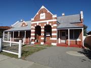
81 Angove St North Perth
North Perth Police Station and Quarters
Vincent
Metropolitan
Constructed from 1908
| Type | Status | Date | Documents |
|---|---|---|---|
| Heritage Agreement | YES | 18 Dec 2009 | HCWebsite.Listing+ListingDocument |
| Heritage List | Adopted | ||
| State Register | Registered | 08 Jan 1999 | HCWebsite.Listing+ListingDocument, HCWebsite.Listing+ListingDocument |
| Type | Status | Date | Documents |
|---|---|---|---|
| (no listings) |
| Type | Status | Date | Grading/Management | |
|---|---|---|---|---|
| Category | ||||
| Classified by the National Trust | Recorded | 04 Mar 1975 | ||
| Municipal Inventory | Adopted | 13 Nov 1995 | Category A | |
| Name | Type | Year From | Year To |
|---|---|---|---|
| Hillson Beasley | Architect | - | - |
| Library Id | Title | Medium | Year Of Publication |
|---|---|---|---|
| 9254 | North Perth Police Station: 81 Angove Street, North Perth. | Heritage Study {Cons'n Plan} | 2009 |
| 5886 | North Perth Police Station : conservation report. | Conservation works report | 1991 |
Individual Building or Group
| Epoch | General | Specific |
|---|---|---|
| Present Use | GOVERNMENTAL | Police Station or Quarters |
| Original Use | GOVERNMENTAL | Police Station or Quarters |
| Style |
|---|
| Federation Free Style |
| Type | General | Specific |
|---|---|---|
| Wall | BRICK | Common Brick |
| Roof | METAL | Corrugated Iron |
| General | Specific |
|---|---|
| SOCIAL & CIVIC ACTIVITIES | Law & order |
This information is provided voluntarily as a public service. The information provided is made available in good faith and is derived from sources believed to be reliable and accurate. However, the information is provided solely on the basis that readers will be responsible for making their own assessment of the matters discussed herein and are advised to verify all relevant representations, statements and information.
Constructed from 1908
North Perth Police Station and Quarters is a fine example of the Federation Free Classical style, by Hillson Beasley. It was the first police station provided in the rapidly developing North Perth area. The Station has continued to be used for police purposes since its construction in 1908. The changes in the nature of the police usage demonstrate the changes in policing practices and training over the past 9 decades. The Station and Quarters also demonstrate a way of police life no longer practiced.
The single storey police station and attached residence has a gable roof with a crippled hipped verandah and a single roof gablet. The distinctive porch of the police station is of red brick with cement rendered bands, a design popularly named 'blood and bandages'. The place is an integral element of the residential streetscape. It is setback to align with adjacent dwellings. A low timber framed and cyclone mesh fence delineates the front boundary. None apparent to the street. Additions to the rear.
The place was built in 1908, as a police station with living quarters attached for the officer in charge. It was believed at the time that a formal police presence was necessary for the rapidly developing suburb of North Perth. The Police Force in WA grew from 207 men in 1890 to 492 in 1906, in keeping with the growth of the population during the gold boom years. North Perth was one of 11 police stations built between 1890 and 1910. Its design and construction of the place would have been overseen by Hillson Beasley, Chief Architect of the Public Works Deparment (PWD) at that time. Tenders for construction were called on 14 August 1907 and contractors and timber merchants, J. T. Franklin & J. Finlay won the work with a price of £816. Franklin & Finlay were also responsible for the Brisbane Street Post Office. Foot Constable James Strappe, who had been the Constable in the area since 1903, became the Officer in Charge at the new station, which boasted a staff of one. From 1910 to 1934, Constable William Crawford was in residence. In 1935 the resident officer in charge was Francis T Ward and in 1947 it was Sergeant George McK.Flanders. During the 1960s, an additional room and a two-car garage were added. In 1975, when a police van demolished the toilet building in the back yard, new toilets were built adjoining the back of the building. Then in 1978, the quarters, which had been occupied continuously by the Officer in Charge of the station, were taken over by the Lecturing Branch of the Police Department. In 1979, the Quarters were again occupied by the Officer in Charge but, in more recent years, the Quarters have again been utilised as a training area. On 24 October 2009, the property was sold at Auction to the Town of Vincent. A new use for the site has yet to be determined.
Intact
| Name | Type | Year From | Year To |
|---|---|---|---|
| Hillson Beasley | Architect | - | - |
This information is provided voluntarily as a public service. The information provided is made available in good faith and is derived from sources believed to be reliable and accurate. However, the information is provided solely on the basis that readers will be responsible for making their own assessment of the matters discussed herein and are advised to verify all relevant representations, statements and information.