Local Government
Vincent
Region
Metropolitan
121 Charles St West Perth
Vincent
Metropolitan
Constructed from 1904
| Type | Status | Date | Documents |
|---|---|---|---|
| Heritage List | Adopted |
| Type | Status | Date | Documents |
|---|---|---|---|
| RHP - Does not warrant assessment | Current | 25 Nov 2011 |
| Type | Status | Date | Grading/Management | |
|---|---|---|---|---|
| Category | ||||
| Municipal Inventory | Adopted | 12 Sep 2006 | Category A | |
Individual Building or Group
| Epoch | General | Specific |
|---|---|---|
| Original Use | RESIDENTIAL | Conjoined residence |
| Present Use | RESIDENTIAL | Conjoined residence |
| Type | General | Specific |
|---|---|---|
| Roof | METAL | Corrugated Iron |
| Other | TIMBER | Other Timber |
| Wall | BRICK | Face Brick |
| General | Specific |
|---|---|
| DEMOGRAPHIC SETTLEMENT & MOBILITY | Settlements |
This information is provided voluntarily as a public service. The information provided is made available in good faith and is derived from sources believed to be reliable and accurate. However, the information is provided solely on the basis that readers will be responsible for making their own assessment of the matters discussed herein and are advised to verify all relevant representations, statements and information.
Constructed from 1904
The fine, large residence, at 125 Charles Street, is rare and an exemplar of a Federation Beaux Arts bungalow. It demonstrates the confidence of the early developers in the future of this area with its raised topography and views to central Perth, Parliament House and Kings Park. The place has social significance for its associations with the Wholley family, the Anglican Church and the Greek Orthodox community.
The single storey dwelling is elevated at the front, with a raised verndah to the front and side. Main access is provided by sweeping curved concrete staircase with low rendered balustrades and pillars at the base. The place is a clever balance between the symmetry of the house and the assymmetry of the verandah, which is resolved with a formal geometry denoting Beaux Arts priciples of composition. The body of the house is symmetrical, with a high pitched hipped roof that features a centre top gablet and twin gables over the rectangular bay windows that flank the central front door. A bullnose verandah runs the entire width of the frontage. It is supported by turned timber posts with a spindled valence. The entry is aediculated. The verandah is constructed on a face limestone retaining wall. The front wall is face brick with a horizontal rendered band. The windows are pairs of double hung sashes. Elevated from the front boundary behind a brick pier and palisade fence with lawns and minimal plantings in setback. None apparent
In 1904, a building permit was issued for No 125 Charles Street to P. Wholley, of the business of Wholley and Walsh. The residence appears in the 1905 Post Office Directory but it was numbered as 173. In 1915, Mrs Beatrice Wholley was listed as the occupant and by 1916 the number had changed to 143. The residence was situated in a rapidly developing area, with a new State School around the corner on Newcastle Street (West Perth Public School at No. 480 Newcastle Street), and the Methodist Mission Chapel and Church in the same street block. On the opposite side of Charles Street, a galvanised iron building had been constructed in 1897, as St Paul's Anglican Church. Sometime shortly before 1916 (it was listed in Wise's Post Office Directories for the first time that year), a new church building was constructed on the corner of Charles and Carr streets, adjoining No 125, which was purchased as the presbytery. No rector was listed in 1916 but the following year, Reverend Llyod Wilson (BD) was listed as the incumbent. He was followed by Reverend George R. Holland in 1920. IN 1949 Reverend C.A Walsh was in situ. He later became a Canon and transferred to St Luke's Anglican Church in Cottesloe. In the 1920's and 1930's, Greek migrants to Perth, many of whom came from the island of Castellorizo (megisti), settled in Northbridge. They established the Church of St Michael and St Helene in Parker Street in 1936 with funds raised from within the Greek community. Following World War II, a new wave of migrants came from Greece. Many of these were also Castellorizians, and among them was a family who brought a religious icon with them. This was the Icon of the Annunciation of Our Lady, which had originally been installed in the church of that name in Antifelo in Asia Minor, only kilometres from Castellorizo. Following the Greco-Turkish War of 1921 the Icon was removed to Castellorizo where it remained for 25 years before being brought to Perth. The new Greek migrants wanted another church where the icon could be installed. In March 1958, a committee established for the purpose, purchased the Anglican Church of St Paul's and its presbytery (No. 125 Charles Street). Following some alterations to the building, the first liturgy was held in the new Church of the Annunciations of Our Lady on 6 December 1958 and the Church was consecrated on 9 August 1959. The building was extensively renovated in 1970 so that it took in the stylistic features of the typical Greek Orthodox Churches. In the following years, another two houses in Charles Street were bought to cater for the needs of the community as well as those of the Hellenic Christian Ladies' Unions and the Greek Orthodox Youth League of WA. A school was established in 1971 in a transportable building in the church grounds. The residence on the west side of the Church at No. 59 Carr Stret was later purchased for use as a Greek School. By 2007 the church owned all the land from No. 121 on the corner of Prospect Place to No. 129, the last Charles Street address before the church on the corner of Carr, the address of which is No. 59 Carr Street. In March 1958, St Paul's Church, and its presbytery, were purchased by the Greek Orthodox community. The church was reconsecrated as the Greek Church of the Annunciation of Our Lady.
High degree
This information is provided voluntarily as a public service. The information provided is made available in good faith and is derived from sources believed to be reliable and accurate. However, the information is provided solely on the basis that readers will be responsible for making their own assessment of the matters discussed herein and are advised to verify all relevant representations, statements and information.

121 & 129 Charles St West Perth
Corner of Charles and Carr Sts.
St Paul's Anglican Church (fmr)
Vincent
Metropolitan
Constructed from 1970, Constructed from 1916
| Type | Status | Date | Documents |
|---|---|---|---|
| Heritage List | Adopted |
| Type | Status | Date | Documents |
|---|---|---|---|
| RHP - To be assessed | Current | 25 Nov 2011 |
| Type | Status | Date | Grading/Management | |
|---|---|---|---|---|
| Category | ||||
| Municipal Inventory | Adopted | 13 Nov 1995 | Category A | |
The place is an unusual example of an Inter-War Romanesque style church with Greek Orthodox elements.
The place is representative of the increase in the Greek population in Perth following WWII and the requirement to facilitate their religious needs.
The place is a local landmark and contributed to the local community’s sense of place, and the Greek community’s sense of identity.
The large Orthodox church is situated on the corners of Carr Street and Charles Street in West Perth. The place was adapted from an existing Anglican church. The entrance of the building is flanked with two open towers with domed roof each topped with a cross. A domed lantern was added over the crossing of the church, which is topped with a Greek Cross. A semi-circular apse was added to the sanctuary east wall and all walls were heavily rendered.
The first St Paul’s Anglican Church was opened on Charles Street, West Perth in August 1897, which remained in use until c. 1913 when the records of this church and its activities vanish. Presumably the first St Paul’s became too small for the growing Anglican population, and records show the construction of a new Anglican Church was approved and began in 1916 with the laying of the foundation stone on 10 June 1916. It is unclear whether the 1897 St Paul’s was demolished or incorporated into the new church structure.
Individual Building or Group
| Epoch | General | Specific |
|---|---|---|
| Original Use | RELIGIOUS | Church, Cathedral or Chapel |
| Present Use | RELIGIOUS | Church, Cathedral or Chapel |
| Style |
|---|
| Federation Gothic |
| Type | General | Specific |
|---|---|---|
| Wall | BRICK | Common Brick |
| Roof | TILE | Other Tile |
| Wall | BRICK | Rendered Brick |
| Wall | CONCRETE | Other Concrete |
| General | Specific |
|---|---|
| DEMOGRAPHIC SETTLEMENT & MOBILITY | Immigration, emigration & refugees |
| SOCIAL & CIVIC ACTIVITIES | Religion |
This information is provided voluntarily as a public service. The information provided is made available in good faith and is derived from sources believed to be reliable and accurate. However, the information is provided solely on the basis that readers will be responsible for making their own assessment of the matters discussed herein and are advised to verify all relevant representations, statements and information.
Constructed from 1916 to 1970
The Greek Orthodox Church of the Annunciation of Our Lady is a major adaptation of an earlier large Anglican Church, that was purchased and extensively changed to suit the worship needs of the local Greek community. The current church demonstrates the contemporary requirements of the hierarchy of the Greek Orthodox Church, for a place of worship. The church houses an historic icon of the Annunciation of Our Lady, from which it takes its name. The church is well known and widely associated with the Greek community of Perth.
A large Orthodox church adapted from a former sizable Anglican church over two major campaigns. The church now features those elements which were required of Greek Orthodox churches - a domed lantern over the crossing topped with a Greek cross, a pair of open towers with domed roofs, topped by Greek crosses, flanking the west façade, a semi circular apse on the sanctuary east wall. In the towers and west façade the original windows were replaced with concrete panels incorporating regular patterns of circular coloured glass windows. The walls are heavily rendered. The church stands in isolation 1970 extensive modification
Carr Street was named after GJ.G.C Carr, Merchant of Perth. His business was on the site of the AMP Buildings in Perth. he was also Chairman of Perth City Council about 1872. It was originally known as Leeder Street, hainvg been named after William John Leeder, an early colonist, and it appeared on the Land's Department's 1858 plan. The name changed to Carr Street around 1902. The church building on the corner of Carr and Charles Street was originally St Paul's Anglican Church. It was constructed some time shortly before 1916 as it was first listed in the Post Office Directories in that year. No rector was listed in 1916 but the following year, Reverand Lloyd Wilson (BD) was listed as the incumbent. He was followed by Reverend George R. Holland in 1920. In 1949 Reverand C.A Walsh was in situ. He later became a Canon and transferred to St Luke's in Cottesloe. n the 1920s and 1930s, Greek migrants to Perth, many of whom came from the island of Castellorizo (Megisti), settled in Northbridge. They established the Church of St Michael and St Helene in Parker Street in 1936 with funds raised from within the Greek community. Following World War 11, a new wave of migrants came from Greece. Many of these were also Castellorizian, and among them was a family who had brought a religious icon within them. This was the Icon of the Annunciation of Our Lady, which had originally been installed in the church of that name in Antifelo in Asia Minor, only kilometres from Castellorizo. Following the Greco-Turkish War of 1921 the Icon was removed to Castellorizo where it remained for 25 years before being brought to Perth. The new Greek migrants wanted another church, where the icon could be installed. In March 1958, a committee established for the purpose purchased the Anglican Church of St Paul's and its presbytery (No. 125 Charles Street). Following some alterations to the building the first liturgy was held in the new Church of the Annunciation of Our Lady on 6 December 1958 and the Church was consecrated on 9 August 1959. The building was extensively renovated in 1970 so that it took on stylistic features typical of Greek Orthodox churches. In the following years, the two houses next to the Church, in Charles Street, were bought to cater for the needs of the community as well as those of the Hellenic Christian Ladies' Union and the Greek Orthodox Youth League of WA. A school was established in 1971 in a transportable building in the church grounds. The residence on the west side of the Church, at No. 59 Carr Street was later purchased for the use of the Greek School.
Post war intact
This information is provided voluntarily as a public service. The information provided is made available in good faith and is derived from sources believed to be reliable and accurate. However, the information is provided solely on the basis that readers will be responsible for making their own assessment of the matters discussed herein and are advised to verify all relevant representations, statements and information.
67 Cleaver St West Perth
Vincent
Metropolitan
Constructed from 1910 to 1914
| Type | Status | Date | Documents |
|---|---|---|---|
| Heritage List | Adopted |
| Type | Status | Date | Documents |
|---|---|---|---|
| RHP - To be assessed | Current | 25 Nov 2011 |
| Type | Status | Date | Grading/Management | |
|---|---|---|---|---|
| Category | ||||
| Municipal Inventory | Adopted | 12 Sep 2006 | Category A | |
The place in a fine example of a single storey residence constructed in both the Federation Queen Anne and Federation Filigree styles.
The place is associated with Florence Hummerston.
The single storey red and white brick former residence with white Filigree verandah faces Cleaver Street, but is set quite far back from the road, leaving space for what is now a car park but presumably was once garden space. Parts of the former residence are delicately detailed, including the front verandah, street facing gables and chimneys. The former residence is now part of a retirement village, it is unknown whether the building now accommodated residence or is used for administration purposes.
After the Swan River Colony was established in 1829, settlement by the colonists began settling in and around the Perth area. The area to the north of the Perth was part wetlands stretching 50 or 60 miles northwards, and was not considered an ideal site for settlement. However, despite the swampy conditions, by the early 1830s land to the north of Perth was beginning to be being settled, and land had been granted to individuals such as John H. Monger, William Leeder, Thomas Mews. Drainage of the lakes close to the city begun in the 1840s freeing up additional land for settlement. With the arrival of convicts from the 1850s, infrastructure and public works increased and improved. Some basic roads were constructed with convict labour, but the area now known at the Town of Vincent was mainly occupied by dairy farmers, markets and gardens and the roadways were left as gravel. During the latter part of the nineteenth century, the Town of Vincent area was subdivided and slowly populated with residences, workers cottages, hotels, and churches.
The site currently functions as a retirement village,. The property has had a number of additions to the south and east to accommodate additional structures. It is unclear what physical alterations have been made to the former residence.
| Library Id | Title | Medium | Year Of Publication |
|---|---|---|---|
| 11586 | Florence Hummerston Lodge, 67 cleaver Street, West Perth | Archival Record | 2017 |
Individual Building or Group
| Epoch | General | Specific |
|---|---|---|
| Present Use | RESIDENTIAL | Single storey residence |
| Present Use | RESIDENTIAL | Institutional Housing |
| Original Use | RESIDENTIAL | Single storey residence |
| Style |
|---|
| Federation Filigree |
| Federation Queen Anne |
| Type | General | Specific |
|---|---|---|
| Other | TIMBER | Other Timber |
| Wall | BRICK | Rendered Brick |
| Roof | METAL | Other Metal |
| Other | RENDER | Roughcast |
| Wall | BRICK | Face Brick |
| General | Specific |
|---|---|
| SOCIAL & CIVIC ACTIVITIES | Community services & utilities |
| DEMOGRAPHIC SETTLEMENT & MOBILITY | Settlements |
This information is provided voluntarily as a public service. The information provided is made available in good faith and is derived from sources believed to be reliable and accurate. However, the information is provided solely on the basis that readers will be responsible for making their own assessment of the matters discussed herein and are advised to verify all relevant representations, statements and information.
Constructed from 1910 to 1914
Florence Hummerston Lodge at 67 Cleaver Street has considerable social significance because of its associations with the Prowse, Veryard and Tormey families and more latterly Florence Hummerston and its subsequent conversion to community purposes. The residence is a fine and noteworthy example of the Federation Queen Anne style and demonstrates the kind of residence constructed for a manager of a commercial insurance firm in early twentieth century Perth. It is not dissimilar in character to the notable Duffel residence, designed by Hine and Selby, opposite the Subiaco Memorial Clock Tower.
The single storey two room frontage dwelling has a hipped roof with a prominent and decorative flying front gable, which is bracketed from the wall below and richly detailed with scalloped timber and fretwork in addition to stucco motifs on the roughcast. The verandah is supported by turned timber posts and has a decorative valance and brackets. The entry is marked by an arched entry portico that is detailed similarly to the flying gable. The walls are brick with rendered bands at sill and head height of windows. One side wall has been rendered to a height of approximately 0.900 metres. The chimneys are roughcast and render with a moulded corbelled detail and single pots. Setback with gardens and paving but included in the Lodge facility Various and recent adaptations
From 1901 to 1904 Cleaver Street was known as Smith Street and then in 1904 reverted back to its original name. No. 67 Cleaver Street was built between 1910 and 1914 for John H. Prowse, manager of the United Insurance Company. John Prowse's daughter Edith, married Charles Veryard, an AMP representative, business owner and a former Lord Mayor of Perth. Later occupants were the Styles, Iddon and Tormey families. Mr Tormey worked for the West Australian Railways and during his residence the place was known as 'Tormey House'. The residence is shown as No. 69 on the MWSSDD sewerage plan - a large house on a double block. It is reputed to have had a large oval lawn, a rose garden and blue Plumbago hedge. In 1949 the resident at No. 61 was George A. James and the occupant of No. 67 Charles J. Price. The League of Home Help for Sick & Aged (inc) was founded in 1953 and Mrs Florence Hummerston was one of the organisers and its foundation president. Mrs Hummerston was also one of the founders of Meals on Wheels the following year. She became a Perth City Councillor and was Perth's first female Councillor. In 1960 she was awarded an OBE (Order of the British Empire). No. 67 was purchased by bthe Leage in 1956 and after extensive alterations it became its headquarters. It was officially opened on 23 August 1957 by WA Premier A.R.G Hawke and part of the building became a centre for the Meals on Wheels community Service. In January 1963, the group purchased No. 61 for a home for elderly men and in September that year No. 71 was added as a home for elderly women. In 1965 extensions were made to the kitchen for Meals on Wheels, the meals being delivered daily to the suburban centres. No. 73 was purchased by the League in 1968 and alterations made to provide a home for the frail aged. On 22 May 1969 this was opened by Perth's Lord Mayor, Tom Wardle as the Florence Hummerston Lodge.
Moderate degree
This information is provided voluntarily as a public service. The information provided is made available in good faith and is derived from sources believed to be reliable and accurate. However, the information is provided solely on the basis that readers will be responsible for making their own assessment of the matters discussed herein and are advised to verify all relevant representations, statements and information.
Colin St West Perth
Vincent
Metropolitan
Constructed from 1980 to 2002
| Type | Status | Date | Documents |
|---|---|---|---|
| (no listings) |
| Type | Status | Date | Documents |
|---|---|---|---|
| RHP - Does not warrant assessment | Current | 30 Jul 2004 |
| Type | Status | Date | Grading/Management | |
|---|---|---|---|---|
| Category | ||||
| Anglican Church Inventory | YES | 31 Jul 1996 | ||
Good
| Name | Type | Year From | Year To |
|---|---|---|---|
| Percy William Harrison | Architect | - | - |
Individual Building or Group
| Epoch | General | Specific |
|---|---|---|
| Present Use | RELIGIOUS | Church, Cathedral or Chapel |
| Original Use | RELIGIOUS | Church, Cathedral or Chapel |
| Style |
|---|
| Late 20th-Century Brutalist |
| Type | General | Specific |
|---|---|---|
| Other | METAL | Steel |
| Wall | CONCRETE | Other Concrete |
| General | Specific |
|---|---|
| SOCIAL & CIVIC ACTIVITIES | Religion |
This information is provided voluntarily as a public service. The information provided is made available in good faith and is derived from sources believed to be reliable and accurate. However, the information is provided solely on the basis that readers will be responsible for making their own assessment of the matters discussed herein and are advised to verify all relevant representations, statements and information.
17-19 Cowle St West Perth
Vincent
Metropolitan
Constructed from 1899
| Type | Status | Date | Documents |
|---|---|---|---|
| Heritage List | Adopted |
| Type | Status | Date | Documents |
|---|---|---|---|
| (no listings) |
| Type | Status | Date | Grading/Management | |
|---|---|---|---|---|
| Category | ||||
| Municipal Inventory | Adopted | 13 Nov 1995 | Category B | |
Individual Building or Group
| Epoch | General | Specific |
|---|---|---|
| Present Use | RESIDENTIAL | Terrace housing |
| Original Use | RESIDENTIAL | Terrace housing |
| Style |
|---|
| Federation Filigree |
| Federation Queen Anne |
| Type | General | Specific |
|---|---|---|
| Other | TIMBER | Other Timber |
| Roof | METAL | Corrugated Iron |
| Wall | BRICK | Common Brick |
| General | Specific |
|---|---|
| DEMOGRAPHIC SETTLEMENT & MOBILITY | Settlements |
This information is provided voluntarily as a public service. The information provided is made available in good faith and is derived from sources believed to be reliable and accurate. However, the information is provided solely on the basis that readers will be responsible for making their own assessment of the matters discussed herein and are advised to verify all relevant representations, statements and information.
Constructed from 1899
"The place has some aesthetic value as a fine example of a two storey terraces constructed in the Federation Filigree style. The place has some rarity value as a semi-detached two storey terraces constructed in the Federation Filigree style of which there are few examples remaining within the Town of Vincent."
"The semi-detached two storey terraces were constructed in 1898 in the Federation Filigree style of architecture as a mirror pair. The terraces are constructed in brick with a medium pitched gabled roof that is clad in corrugated galvanised iron. The two terraces are separated by a firewall of which features minor detailing on its end. The facade of each terrace has asymmetrical fenestration on the lower storey. The entry doors are panelled with timber and glass and have a fanlight of which adjacent are two double hang sash windows with multiple window panes on the upper sash. The upper storey features a symmetrical fenestration with two French doors and fanlight opening on to the upper storey verandah for each terrace. The upper facade features a simple parapet and a chimney is featured in the centre of each dwelling positioned behind the parapet. The balconies of the terraces are supported by turned timber posts, balustrades, fretwork brackets and valances. There is no front fence delineating the dwellings from the street and a small landscaped garden is present at the front of the two dwellings. A series of concrete steps lead up to the front verandah of the two dwellings."
"Cowle Street is located on the former Lake Henderson, which was part of the lake and wetland system which covered much of the Perth area. Due to the arrival of convicts and pensioner guards which increased the population, market gardens were established on some of the lakes which had been drained. Lake Henderson was drained in the early 1870s, with the drain running through Dorrien Gardens, Robertson Park and beyond, and it was farmed by European market gardeners. In the 1870s Charles Street became a major road in the area and the settlers established dairy farms and market gardens along its length, such as in the area along Cowle Street. The land of Lake Henderson was taken up quickly for market gardens, one area was bought by James Fox, at what is now Robertson Park. After the European market gardeners, many Chinese immigrants developed their own market gardens in the same area until the 1920's and 1930's. The closest one was at the rear of the houses opposite, on what is now known as Dorrien Gardens. In the 1930's it was run by Kai. The first land sales on the street took place in June 1870 indicating that the street was likely to have been in existence at this time. It certainly appeared on an early Colonial map dated 1877. The street appears to have been named in honour of Mr James Cowle who was appointed as an Assistant Surveyor in the Survey Department from 20 January 1895 of which he carried out surveys in many different districts from North Perth to Bunbury. The street is located on a distinct slope with the houses on the south side built well above road level while those on the northern side are set below. In June 1870, Perth Town Lot Y207 located on the northern side of the street, was the first lot of land sold along Cowle Street by the Colonial Government and by 1872 all of the lots on the that side had been sold. Development of the land on the southern side of the street took place later than the southern side, between 1875 and 1878. The earliest dwelling to have been constructed in the street was No. 54 Cowle Street on the northern side of the street. This property was owned by market gardener Wlater Edward Joseph Gallop (Joseph) who is recorded in the City of Perth Rate Books as the owner of No. 54 Cowle Street at the time it was constructed in 1884. Joseph Gallop had arrived in Western Australia in 1829 with his brothers Edward and James (the great great grandfather of the former WA Premier Geoff Gallop.) Joseph Gallop died in the 1890s and the land was passed onto his two daughters. Gallop Street, located nearby, is named after him. After the European market gardeners, many Chinese immigrants developed their own market gardens in the same area until the 1920s. The subject dwellings at Nos. 17 - 19 Cowle Street were constructed in 1898 by a music teacher Mr Edmund Carige. No. 17 was rented to Miss Hawks, also a music teacher in 1899 and Mr Carige lived in No. 19. The dwellings were owned by Harold Radford from 1920 - 1922, Hermina Scholes from 1922 - 1926, Daisy DePedro from 1926 - 1931 and then Henry Solman from 1932 - 19476. The City of Perth Building Licence Cards indicated that Mr Solman undertook alterations to the dwelling in 1932 and no residents were occupying the dwelling during that year. The Wise's Post Office Directories support this information with regard to the construction date with the first listing of the property being in 1898. At that time Mr Robert Arcus resided at No. 17 and a contractor Mr James Couston at No. 19. Robert Arcus stayed at No. 17 until 1902 but the Directories suggest that the dwellings were primarily rented with regularly changing tenants, some of whom were forced to move on when unable to pay their rent. This was a regular occurrence during the 1929 Depression as were visits by bailiffs to try to seize furniture and other items to offset the tenant's debts. The Mundy family lived at No. 19 before moving across the road to No. 28 some time after 1930. Their neighbour at No. 21 was known as 'Tiger Lil', who was described as a 'lady of the night'. She was murdered later on, but no one was convicted of it. In the first part of the 20th Century the longest residing occupant at the subject dwelling was Arthur F. Phelps who is listed as residing at No. 17 Cowle Street from 1938 until at least 1949."
High No Modifications Apparent
| Reserve | Lot/Location | Plan/Diagram | Vol/Folio |
|---|---|---|---|
| 20 |
This information is provided voluntarily as a public service. The information provided is made available in good faith and is derived from sources believed to be reliable and accurate. However, the information is provided solely on the basis that readers will be responsible for making their own assessment of the matters discussed herein and are advised to verify all relevant representations, statements and information.
28-32 Cowle St West Perth
Vincent
Metropolitan
Constructed from 1891 to 1893
| Type | Status | Date | Documents |
|---|---|---|---|
| Heritage List | Adopted | ||
| Heritage List | Adopted |
| Type | Status | Date | Documents |
|---|---|---|---|
| RHP - Does not warrant assessment | Current | 25 Nov 2011 |
| Type | Status | Date | Grading/Management | |
|---|---|---|---|---|
| Category | ||||
| Municipal Inventory | Adopted | 29 Dec 2006 | Category A | |
| Municipal Inventory | Adopted | 29 Dec 2006 | Category A | |
25108 Cowle Street Precinct, West Perth
Individual Building or Group
| Epoch | General | Specific |
|---|---|---|
| Present Use | RESIDENTIAL | Conjoined residence |
| Original Use | RESIDENTIAL | Conjoined residence |
| Style |
|---|
| Old Colonial Georgian |
| Type | General | Specific |
|---|---|---|
| Roof | METAL | Corrugated Iron |
| Wall | BRICK | Face Brick |
| Wall | BRICK | Rendered Brick |
| General | Specific |
|---|---|
| DEMOGRAPHIC SETTLEMENT & MOBILITY | Settlements |
This information is provided voluntarily as a public service. The information provided is made available in good faith and is derived from sources believed to be reliable and accurate. However, the information is provided solely on the basis that readers will be responsible for making their own assessment of the matters discussed herein and are advised to verify all relevant representations, statements and information.
Constructed from 1891
The place has considerable aesthetic value as a good example of the Convict and Late Colonial Georgian styles. The place has considerable historic value as a good example of one of the earliest worker’s dwellings built in the area prior to the Gold Boom period.
The semi-detached pair is an example of the Convict and Late Colonial Georgian style. The dwellings consist of a mirrored pair, which have symmetrical façades. Each front door is located in the centre of the façade and flanked by two multi-paned sash windows. The front door to the western portion of dwelling has a metal security door while the other front door has a timber framed fly screen door. The front façade has been rendered and a narrow party wall projects from the centre of the facade. The dwellings have a hipped roof and a separate concave bell verandah, which is an uncommon feature of dwellings in the Town. The verandah is supported by square metal posts of which are not the original. The roof and verandah are clad in red corrugated iron. The chimneys are located at the ends of the dwelling. The chimneys are constructed using bricks which are corbelled near the top. The façade wall is constructed with Flemish brickwork bond. The side walls are in the English Garden Wall brickwork bond. The dwelling is delineated from the street by a low brick pier fence which has two parallel metal bars running between the piers. Two metal mesh gates are located symmetrically both ends of the fence forming separate entries to the two dwellings. Internally each dwelling is symmetrical in design and consists of a central hallway with four rooms of similar size projecting from the hallway entered through low waisted timber panelled doors. Entry to the dwellings is through a timber panelled door with a vent above. Timber floorboards run in a north-south direction in the hallway of each of the dwellings and the four front rooms. The original vents and skirtings are still extant and no ceiling roses or cornices are featured in the dwellings. A series of timber steps lead from the rear of the original part of the dwellings to the skillion in which the laundry, kitchen and bathroom are located. The kitchen features a fireplace with a Metter's stove.
Cowle Street is located on the former Lake Henderson, which was part of the lake and wetland system which covered much of the Perth area. Due to the arrival of convicts and pensioner guards which increased the population, market gardens were established on some of the lakes which had been drained. Lake Henderson was drained in the early 1870s, with the drain running through Dorrien Gardens, Robertson Park and beyond and it was farmed by European market gardeners. In the 1870s Charles Street became a major road in the area and settlers established dairy farms and market gardens along its length, such as the area along Cowle Street. The land of Lake Henderson was taken up quickly for market gardens, one area was bought by James Fox, at what is now Robertson Park. The earliest dwelling to have been constructed in Colwe Street was the dwelling at No. 54 Cowle Street. This property was owned by market gardener Walter Edward Joseph Gallop (Joseph) who is recorded in the City of Perth Rate Books as the owner of No. 54 Cowle Street at the time it was constructed in 1884. Joseph Gallop had arrived in Western Australia in 1829 with his brothers Edward and James (great great grandfather of the former WA Premier Geoff Gallop). Joseph Gallop died in the 1890s and the land was passed onto his two daughters. Gallop Street, located nearby, is named after him. After the European market gardeners, many Chinese immigrants developed their own market gardens in the same area until the 1920s. Chinese gardener Hong Cheong is listed as working the reclaimed land behind Nos. 32 and 40 from 1907 to 1916 and in the 1930's another garden further north in Dorrien Gardens was run by Kai. W. E. Bold, who was the Perth City Town Clerk from 1901 to 1944, advocated the '˜City Beautiful' movement where the health of a city's residents was enhanced by the beauty of the environment. To implement this philosophy it was suggested that some of the Chinese market gardens. which had the reputation for being unhealthy areas, be converted to public parks and recreation areas. Some of the land was used to establish Birdwood Square, Hamilton Square, Dorrien Gardens, Lake Monger reserve and Robertson Park. The semi-detached dwellings located at Nos. 28 - 30 Cowle Street were built between 1891 and 1893 and first appeared in the City of Perth Rate Books in 1892. The land was previously owned by Hotelkeeper, John Charles Chipper who also owned the John Bull Inn (now the Criterion Hotel) along Hay Street. His heirs subdivided the land following his death, which included eight blocks in Cowle Street on the north side from the corner of Fitzgerald Street and another seven in Fitzgerald Street (Perth Town Lots Y210, 211, 212, 229, 230 and 231). Chas Crossland & Co. handled the sales of what was advertised as 'splendid building and garden land'. F.D Good purchased the land and Nos. 28 - 30 were constructed in 1891. In 183 they were rented to Frank Bell, a clerk (No. 28), and C.Turner, a surveyor (No. 30). In 1897 Thomas William Wade bought the properties, and his wife Catherine took on ownership in 1911, after his death. The properties were rented out for many years but the street numbers only appear in the Wise's Post Office Directories, in 1904 when Mrs Mulwaur is listed as occupying No. 30. William Nicholls moved in the following year and there was a further change the year after. The first resident listed for No. 28 was Frederick Rogers in 1908. In 1910 the occupants had changed to Frederick Rogers (No. 28) and Michael Dwyer (No. 30). In 1927 David Everett bought the property and lived there until 1929, when he moved next door to No. 32 Cowle Street. That year he constructed about eight tennis courts on the reclaimed land behind Nos. 12 - 32. These operated until at least the 1950's. Andrew Mian states in his historical work, 'A History of Cowle Street, West Perth, Western Australia' that, ' it is claimed that the courts were the first floodlit courts in Perth and were known as the 'Start Tennis Courts'. The entrance to the courts was the driveway between Nos. 30 and 32 and to advertise the tennis courts, a star was painted on the eastern wall of No. 32. Throughout the 20th Century there were many occupants of the dwellings, indicating that for much the time, both were rented. One long term family was the Mundays - Esther May (O'Reilly) and Walter John Munday and their three children, who first moved into No. 29 around 1922 and then to No. 28 from 1935 until well beyond 1949. Their son Harold said that like other children of the time, they were to be seen and not heard and they were sent outside to play when the adults had things to discuss. They played in the street and would 'kick a footy, play cricket against the lamp post, 'throw the tin'. We used to play marbles and we would even play a game called 'follow the tor' and it was down alon ghte gutters of the street. (Harold Munday). It was occupied by the Hicks family in the 1930's and Charlie, their eldest son, played football for West Perth. In 1936 the site of Dorrien Gardens was cleared and in the 1950s the Perth City Council established a soccer ground behind the dwellings on the north side of Cowle Street. In the 1940's the Perth City Council commenced discussion to extend Dorrien Gardens. In a land transfer undertaken in 1969 the land of which the subject place is located was purchased by the Perth City Council from Mrs Emily M Edwards (formerly Everett) and transferred to Mr A.R Roworth in exchange for land to the north of the subject property that was owned by Mr A.R Roworth who lived at No. 40 and operated a nursery on the land at the rear. Once transferred to the City of Perth the land north of the subject place was consolidated with the existing land that formed Dorrien Gardens.
This information is provided voluntarily as a public service. The information provided is made available in good faith and is derived from sources believed to be reliable and accurate. However, the information is provided solely on the basis that readers will be responsible for making their own assessment of the matters discussed herein and are advised to verify all relevant representations, statements and information.
Constructed from 1891
"The place has considerable aesthetic value as a good example of the Convict and Late Colonial Georgian styles. The place has considerable historic value as a good example of one of the earliest worker’s dwellings built in the area prior to the Gold Boom period."
"The semi-detached pair is an example of the Convict and Late Colonial Georgian style. The dwellings consist of a mirrored pair, which have symmetrical façades. Each front door is located in the centre of the façade and flanked by two multi-paned sash windows. The front door to the western portion of dwelling has a metal security door while the other front door has a timber framed fly screen door. The front façade has been rendered and a narrow party wall projects from the centre of the facade. The dwellings have a hipped roof and a separate concave bell verandah, which is an uncommon feature of dwellings in the Town. The verandah is supported by square metal posts of which are not the original. The roof and verandah are clad in red corrugated iron. The chimneys are located at the ends of the dwelling. The chimneys are constructed using bricks which are corbelled near the top. The façade wall is constructed with Flemish brickwork bond. The side walls are in the English Garden Wall brickwork bond. The dwelling is delineated from the street by a low brick pier fence which has two parallel metal bars running between the piers. Two metal mesh gates are located symmetrically both ends of the fence forming separate entries to the two dwellings. Internally each dwelling is symmetrical in design and consists of a central hallway with four rooms of similar size projecting from the hallway entered through low waisted timber panelled doors. Entry to the dwellings is through a timber panelled door with a vent above. Timber floorboards run in a north-south direction in the hallway of each of the dwellings and the four front rooms. The original vents and skirtings are still extant and no ceiling roses or cornices are featured in the dwellings. A series of timber steps lead from the rear of the original part of the dwellings to the skillion in which the laundry, kitchen and bathroom are located. The kitchen features a fireplace with a Metter's stove."
"Cowle Street is located on the former Lake Henderson, which was part of the lake and wetland system which covered much of the Perth area. Due to the arrival of convicts and pensioner guards which increased the population, market gardens were established on some of the lakes which had been drained. Lake Henderson was drained in the early 1870s, with the drain running through Dorrien Gardens, Robertson Park and beyond and it was farmed by European market gardeners. In the 1870s Charles Street became a major road in the area and settlers established dairy farms and market gardens along its length, such as the area along Cowle Street. The land of Lake Henderson was taken up quickly for market gardens, one area was bought by James Fox, at what is now Robertson Park. The earliest dwelling to have been constructed in Colwe Street was the dwelling at No. 54 Cowle Street. This property was owned by market gardener Walter Edward Joseph Gallop (Joseph) who is recorded in the City of Perth Rate Books as the owner of No. 54 Cowle Street at the time it was constructed in 1884. Joseph Gallop had arrived in Western Australia in 1829 with his brothers Edward and James (great great grandfather of the former WA Premier Geoff Gallop). Joseph Gallop died in the 1890s and the land was passed onto his two daughters. Gallop Street, located nearby, is named after him. After the European market gardeners, many Chinese immigrants developed their own market gardens in the same area until the 1920s. Chinese gardener Hong Cheong is listed as working the reclaimed land behind Nos. 32 and 40 from 1907 to 1916 and in the 1930's another garden further north in Dorrien Gardens was run by Kai. W. E. Bold, who was the Perth City Town Clerk from 1901 to 1944, advocated the '˜City Beautiful' movement where the health of a city's residents was enhanced by the beauty of the environment. To implement this philosophy it was suggested that some of the Chinese market gardens. which had the reputation for being unhealthy areas, be converted to public parks and recreation areas. Some of the land was used to establish Birdwood Square, Hamilton Square, Dorrien Gardens, Lake Monger reserve and Robertson Park. The semi-detached dwellings located at Nos. 28 - 30 Cowle Street were built between 1891 and 1893 and first appeared in the City of Perth Rate Books in 1892. The land was previously owned by Hotelkeeper, John Charles Chipper who also owned the John Bull Inn (now the Criterion Hotel) along Hay Street. His heirs subdivided the land following his death, which included eight blocks in Cowle Street on the north side from the corner of Fitzgerald Street and another seven in Fitzgerald Street (Perth Town Lots Y210, 211, 212, 229, 230 and 231). Chas Crossland & Co. handled the sales of what was advertised as 'splendid building and garden land'. F.D Good purchased the land and Nos. 28 - 30 were constructed in 1891. In 183 they were rented to Frank Bell, a clerk (No. 28), and C.Turner, a surveyor (No. 30). In 1897 Thomas William Wade bought the properties, and his wife Catherine took on ownership in 1911, after his death. The properties were rented out for many years but the street numbers only appear in the Wise's Post Office Directories, in 1904 when Mrs Mulwaur is listed as occupying No. 30. William Nicholls moved in the following year and there was a further change the year after. The first resident listed for No. 28 was Frederick Rogers in 1908. In 1910 the occupants had changed to Frederick Rogers (No. 28) and Michael Dwyer (No. 30). In 1927 David Everett bought the property and lived there until 1929, when he moved next door to No. 32 Cowle Street. That year he constructed about eight tennis courts on the reclaimed land behind Nos. 12 - 32. These operated until at least the 1950's. Andrew Mian states in his historical work, 'A History of Cowle Street, West Perth, Western Australia' that, ' it is claimed that the courts were the first floodlit courts in Perth and were known as the 'Start Tennis Courts'. The entrance to the courts was the driveway between Nos. 30 and 32 and to advertise the tennis courts, a star was painted on the eastern wall of No. 32. Throughout the 20th Century there were many occupants of the dwellings, indicating that for much the time, both were rented. One long term family was the Mundays - Esther May (O'Reilly) and Walter John Munday and their three children, who first moved into No. 29 around 1922 and then to No. 28 from 1935 until well beyond 1949. Their son Harold said that like other children of the time, they were to be seen and not heard and they were sent outside to play when the adults had things to discuss. They played in the street and would 'kick a footy, play cricket against the lamp post, 'throw the tin'. We used to play marbles and we would even play a game called 'follow the tor' and it was down alon ghte gutters of the street. (Harold Munday). It was occupied by the Hicks family in the 1930's and Charlie, their eldest son, played football for West Perth. In 1936 the site of Dorrien Gardens was cleared and in the 1950s the Perth City Council established a soccer ground behind the dwellings on the north side of Cowle Street. In the 1940's the Perth City Council commenced discussion to extend Dorrien Gardens. In a land transfer undertaken in 1969 the land of which the subject place is located was purchased by the Perth City Council from Mrs Emily M Edwards (formerly Everett) and transferred to Mr A.R Roworth in exchange for land to the north of the subject property that was owned by Mr A.R Roworth who lived at No. 40 and operated a nursery on the land at the rear. Once transferred to the City of Perth the land north of the subject place was consolidated with the existing land that formed Dorrien Gardens." 1891 - 1919 - Population and Settlement: Residential Development
| Reserve | Lot/Location | Plan/Diagram | Vol/Folio |
|---|---|---|---|
| 13 |
This information is provided voluntarily as a public service. The information provided is made available in good faith and is derived from sources believed to be reliable and accurate. However, the information is provided solely on the basis that readers will be responsible for making their own assessment of the matters discussed herein and are advised to verify all relevant representations, statements and information.
28-70 Cowle St West Perth
Vincent
Metropolitan
Constructed from 1884 to 1940
| Type | Status | Date | Documents |
|---|---|---|---|
| (no listings) |
| Type | Status | Date | Documents |
|---|---|---|---|
| RHP - Does not warrant assessment | Current | 21 Mar 2014 |
| Type | Status | Date | Grading/Management | |
|---|---|---|---|---|
| Category | ||||
| (no listings) | ||||
Precinct or Streetscape
| Epoch | General | Specific |
|---|---|---|
| Original Use | RESIDENTIAL | Single storey residence |
| Present Use | RESIDENTIAL | Single storey residence |
| Style |
|---|
| Victorian Georgian |
| Federation Queen Anne |
| Type | General | Specific |
|---|---|---|
| Roof | METAL | Corrugated Iron |
| Wall | BRICK | Common Brick |
| General | Specific |
|---|---|
| DEMOGRAPHIC SETTLEMENT & MOBILITY | Land allocation & subdivision |
| DEMOGRAPHIC SETTLEMENT & MOBILITY | Settlements |
This information is provided voluntarily as a public service. The information provided is made available in good faith and is derived from sources believed to be reliable and accurate. However, the information is provided solely on the basis that readers will be responsible for making their own assessment of the matters discussed herein and are advised to verify all relevant representations, statements and information.
5-11 Cowle St West Perth
No 5 is also known as 'Lena Cottage' No 7 is also known as 'Ivy Cottage'
Vincent
Metropolitan
Constructed from 1896 to 1970
| Type | Status | Date | Documents |
|---|---|---|---|
| Heritage List | Adopted | 21 Sep 2006 |
| Type | Status | Date | Documents |
|---|---|---|---|
| (no listings) |
| Type | Status | Date | Grading/Management | |
|---|---|---|---|---|
| Category | ||||
| Municipal Inventory | Adopted | 21 Sep 2006 | Category B | |
Individual Building or Group
| Epoch | General | Specific |
|---|---|---|
| Original Use | RESIDENTIAL | Conjoined residence |
| Present Use | RESIDENTIAL | Conjoined residence |
| Style |
|---|
| Federation Italianate |
| Type | General | Specific |
|---|---|---|
| Wall | BRICK | Rendered Brick |
| Roof | METAL | Corrugated Iron |
| Wall | BRICK | Face Brick |
| General | Specific |
|---|---|
| DEMOGRAPHIC SETTLEMENT & MOBILITY | Settlements |
This information is provided voluntarily as a public service. The information provided is made available in good faith and is derived from sources believed to be reliable and accurate. However, the information is provided solely on the basis that readers will be responsible for making their own assessment of the matters discussed herein and are advised to verify all relevant representations, statements and information.
Constructed from 1912, Constructed from 1896
The houses at Nos. 7, 9 and 13 & 15 Cowle Street demonstrate the rapidity of changing forms and styles of inner city workers housing during the transition from Late Colonial to the Federation Period.
"The abutting dwellings at No. 5 and No. 7 Cowle Street are identical in design with the name 'Lena Cottage' inscribed on the the stepped pediment of No. 5 'Ivy Cottage' on No.7. The two dwellings feature front verandahs with a bullnose roof supported by by turned timber posts and filigree angles and valance. The front windows are a pair of spaced double hung sashes. The abutting dwellings at No. 5 and No. 7 Cowle Street are a pattern book model borrowed from the eastern states where detatched dwellings were often constructed in similar details to form rows or terraces. Internally the dwelling at No. 7 Cowle Street features a hallway which extends along the eastern portion of the dwelling with three rooms projecting to the west of the hallway. The rear of the dwelling features the bathroom and open kitchen and living area of which is likely to have been constructed in the 1970's. A small courtyard is featured to the rear of the dwelling. It can be assumed that the internal design of No. 5 Cowle Street is similar. No. 9 Cowle Street is a brick and iron dwelling constructed in the Late Colonial Georgian style of architecture, featuring the typical symmetrical features of this style with a central doorway and casement windows either side. No. 9 Cowle Street is a detached cottage located between parapet side walls. The dwelling has a single room frontage and the front entrance and hallway extend along the eastern boundary of the dwelling. The dwelling features a bull nose verandah supported by timber turnposts. Minimal setback from the street with a brick and palisade fence with a garden evident. "
"Colwe Street was named about 1870 after James Cowle, a government surveyor who surveyed the allotments in the area. It borders Dorrien Gardens, a recreation area development on the former Lake Henderson. Market gardening activities were carried out on the bed of Lake Henderson after it was drained in the early 1870's, the drain running through Dorrien Gardens, Robertson Park and beyond. The European gardeners were followed by Chinese market gardners who operated until the early 1920's. The earliest residence in the street date from 1884, and at least 10 existing places are shown on the 1897 PWD sewerage plans. In the 1950's, the Perth City Council acquired the vacant land behind the residences on the north side of the street and established a soccer ground, Dorrien Gardens Reserve, on the former lake bed. Lot Y198 encompassing what are now Nos. 5, 7, 9 and 13 & 15 Cowle Street was sold on 6 October 1875 for 9 pounds. John Elsegood, the original owner of this land also owned Y199 and Y201. Mr Elsewood was contracted to erect the Perth-Albany-Eucla telegraph line in the 1870's. In 1897 he was the proprietor of the City Hotel on the corner of Murray and King Streets and in the 1880's he established the Guildford brickworks. The subject dwelling at No. 5 Cowle Street 'Lena Cottage' first appears in the City of Perth Rates book in 1900 with the owner being Mr John Campbell a Railway employee, who built the two cottages at No. 5 and No. 7 Cowle Street. Campbell, a plumber resided at No. 5, and rented out No. 7 or 'Ivy Cottage' (rented to Mrs Collins in 1900). Campbell sold both of the properties in 1913. This information correlates partly with the information in the Wise's Postal Directory which shows that J.C Campbell resided at No. 5 (numbered No. 3 in the Wise Postal Directory in 1900) and Joseph Collins at No. 7 (listed as No. 5). This is the only reference there to a Mr Campbell residing in Cowle Street during the early part of the 20th century. The Wise's Post Office Directories also indicate that both Nos. 5 and 7 Cowle Street were generally leased, with rapid turn overs in tenancies. In 1909 No. 5 and No. 7 Cowle Street are listed for the first time as the numbers by which they are known today, with the occupier of No. 5 being Mrs Margaret Foley and Mr William Opie residing at No. 7 Cowle Street. Prior to 1909 the numbering of the two dwellings is irregular with No. 3 being listed as what is now No. 5 and No. 5 listed as what is now No. 7 Cowle Street. As mentioned above, throughout the first part of the 20th Century the Wise's Post Office Directories reveals a wide variety of tenants to have residing at the subject dwellings at No. 5 and No. 7 Cowle Street. The longest occupant to have resided at No. 5 Cowle Street was Mrs Annie O'Conner (a dress maker) from 1941 until at least 1949 and the longest one at No. 7 Cowle Street was Mr John Baker from 1923 until at least 1949. The Bakers had four children - Bill, Jack, Ronald and Joyce. Bill, a footballer, played for West Perth and was a member of their 1941 Premiership team. After h joined the Amry during World War 11 he played with an army team and coached the younger enlised men. Harold Mundy, a neighbour from No. 28, said that as young boys, he and Jacky and Billy Baker would 'walk right down the river to the foreshorelike Spring Street. Right around, picking up bottles that the yachtsmen had thrown out. We got a sugar bag and carried them all the way back up there to get a halfpenny for them.. each. It was worth it. Better than nothing.'(Harold Mundy). The residence at No. 9 Cowle Street appears on the 1897 PWD sewerage plans, and it is first listed in the City of Perth Rates Books that year. The house was built in 1896 by Michael Park, a retired civil servant who resided there until 1904. The Post Office Directories list him there early on and then some turnover until the Ferrie family in the 1930's. One of their daughters married 'Checker' O'Keefe, another West perth footballer, and the other married Doug Irvine, also a well-known sportsman. By 1949 No. 9 was occupied by Mrs Catherine Irvine. No. 13 & 15 (No. 11) Cowle Street was constructed by Pierce Mangan in 1912 and rented to Cecil Farley that year. A number of changes in tenancy followed: in 1930 it was occupied by Alred Mills and in 1949 by Jack Lynch. Mr Mangan owned a number of other properties in the area, including No. 15 Cowle Street and the family home at No. 48. On his death the properties passed to his children and were eventually disposed of in 2000." 1891 - 1919 - Population and Settlement: Residential Development
Moderate to High
| Reserve | Lot/Location | Plan/Diagram | Vol/Folio |
|---|---|---|---|
| 100 | |||
| 101 | |||
| 13 | |||
| 1 | |||
| 2 |
This information is provided voluntarily as a public service. The information provided is made available in good faith and is derived from sources believed to be reliable and accurate. However, the information is provided solely on the basis that readers will be responsible for making their own assessment of the matters discussed herein and are advised to verify all relevant representations, statements and information.

54 Cowle St West Perth
Vincent
Metropolitan
Constructed from 1884
| Type | Status | Date | Documents |
|---|---|---|---|
| Heritage List | Adopted | ||
| Heritage List | Adopted |
| Type | Status | Date | Documents |
|---|---|---|---|
| RHP - Does not warrant assessment | Current | 30 Mar 2012 |
| Type | Status | Date | Grading/Management | |
|---|---|---|---|---|
| Category | ||||
| Municipal Inventory | Adopted | 29 Dec 2006 | Category B | |
| Municipal Inventory | Adopted | 29 Dec 2006 | ||
25108 Cowle Street Precinct, West Perth
Individual Building or Group
| Epoch | General | Specific |
|---|---|---|
| Original Use | RESIDENTIAL | Single storey residence |
| Present Use | RESIDENTIAL | Single storey residence |
| Style |
|---|
| Federation Queen Anne |
| Federation Bungalow |
| Type | General | Specific |
|---|---|---|
| Wall | BRICK | Face Brick |
| Other | TIMBER | Other Timber |
| Roof | METAL | Corrugated Iron |
| Other | STONE | Limestone |
| Wall | BRICK | Rendered Brick |
| General | Specific |
|---|---|
| DEMOGRAPHIC SETTLEMENT & MOBILITY | Settlements |
This information is provided voluntarily as a public service. The information provided is made available in good faith and is derived from sources believed to be reliable and accurate. However, the information is provided solely on the basis that readers will be responsible for making their own assessment of the matters discussed herein and are advised to verify all relevant representations, statements and information.
Constructed from 1884
"The place has some historic value as one of the few surviving dwellings within the Town of Vincent which dated from 1884 prior to the Gold Boom Period of development; The place has some rarity value as it one of the few remaining dwellings built in 1884 located in the Town of Vincent; The Place has a high degree of integrity, retaining its original use as a residence".
"The dwelling is a Federation Queen Anne Bungalow constructed from brick and red corrugated iron sheeting. It has a front facing gable with a small awning over the bay window. There are three sash windows located on the bay. This front section of the dwelling is an addition to the original rear part of the dwelling that was constructed c1884. A separate skillion verandah extends along the façade of the dwelling and is supported by turned timber posts. Two stucco bands situated at the top and bottom of the windows run along the façade. The front door is situated next to the bay window and two sash windows are located past the front door. Two brick chimneys are located in the rear section of the dwelling and have rendered corbelled and decorative elements. The dwelling has a hipped roof. The west wall is constructed using stretcher bond brickwork, the façade is Flemish bond brickwork and the east wall is constructed using a variation of Common bond brickwork. This bond style is also used in the east wall of the rear section of which is part of the original 1884 section of the dwelling. The west wall of the rear extension has been rendered. The front of the dwelling is built on limestone blocks. A wire mesh fence delineates the property from the street of which a concrete paved pathway leads to the front entrance of the dwelling. The front door opens into a passage which runs the length of the dwelling. The two front rooms located on either side of the passage are large; the room located to the east of the front door has a fireplace located in the corner of the room. The lounge on the west side of the passage has a rectangular ceiling rose and a circular ceiling rose is located in the passage. Near to the fireplace are two floorboards which are broken, creating a hole in a small section of the floor. The passage is divided by a set of timber stairs which follow the steep slope of the block. On the second level there are four rooms, two on each side of the passage. The doors to the rooms are staggered, not opening directly opposite each other. At this point of the passage there is an archway. The first two rooms on the second level are bedrooms and are smaller in dimension to the first two rooms of the dwelling. Beyond the two bedrooms are the kitchen and a storage room. The kitchen has a set of three casement windows. The front and middle part of the dwelling has wide timber floorboards throughout the rooms and passageway. There are high skirting boards located along the passage. The rear of the dwelling has a panelled door opening onto a skillion roofed extension. The door has a three paned fixed fanlight window above it. A brick and skillion roofed addition is located at the rear of the dwelling. The rear skillion has narrow floorboards and has been divided into two rooms, a bathroom and a storage room. This room has two sets of casement windows looking onto the rear of the property. A set of brick and concrete stairs are located outside the backdoor and lead to the backyard. A small brick building is located onto the rear of the dwelling, which is accessed from the ground level, via a timber door. A manhole is located under the skillion addition, allowing access under the dwelling. A corrugated sheeting shed is located a few metres behind the dwelling and a brick toilet is also located behind the dwelling, close to the property boundary with No. 48.
High Former Late Colonial Georgian style facade replaced with Federation Style facade
| Reserve | Lot/Location | Plan/Diagram | Vol/Folio |
|---|---|---|---|
| 41 |
This information is provided voluntarily as a public service. The information provided is made available in good faith and is derived from sources believed to be reliable and accurate. However, the information is provided solely on the basis that readers will be responsible for making their own assessment of the matters discussed herein and are advised to verify all relevant representations, statements and information.
Constructed from 1884
The place has some historic value as one of the few surviving dwellings within the Town of Vincent which dated from 1884 prior to the Gold Boom Period of development; The place has some rarity value as it one of the few remaining dwellings built in 1884 located in the Town of Vincent; The Place has a high degree of integrity, retaining its original use as a residence.
The dwelling is a Federation Queen Anne Bungalow constructed from brick and red corrugated iron sheeting. It has a front facing gable with a small awning over the bay window. There are three sash windows located on the bay. This front section of the dwelling is an addition to the original rear part of the dwelling that was constructed c1884. A separate skillion verandah extends along the façade of the dwelling and is supported by turned timber posts. Two stucco bands situated at the top and bottom of the windows run along the façade. The front door is situated next to the bay window and two sash windows are located past the front door. Two brick chimneys are located in the rear section of the dwelling and have rendered corbelled and decorative elements. The dwelling has a hipped roof. The west wall is constructed using stretcher bond brickwork, the façade is Flemish bond brickwork and the east wall is constructed using a variation of Common bond brickwork. This bond style is also used in the east wall of the rear section of which is part of the original 1884 section of the dwelling. The west wall of the rear extension has been rendered. The front of the dwelling is built on limestone blocks. A wire mesh fence delineates the property from the street of which a concrete paved pathway leads to the front entrance of the dwelling. The front door opens into a passage which runs the length of the dwelling. The two front rooms located on either side of the passage are large; the room located to the east of the front door has a fireplace located in the corner of the room. The lounge on the west side of the passage has a rectangular ceiling rose and a circular ceiling rose is located in the passage. Near to the fireplace are two floorboards which are broken, creating a hole in a small section of the floor. The passage is divided by a set of timber stairs which follow the steep slope of the block. On the second level there are four rooms, two on each side of the passage. The doors to the rooms are staggered, not opening directly opposite each other. At this point of the passage there is an archway. The first two rooms on the second level are bedrooms and are smaller in dimension to the first two rooms of the dwelling. Beyond the two bedrooms are the kitchen and a storage room. The kitchen has a set of three casement windows. The front and middle part of the dwelling has wide timber floorboards throughout the rooms and passageway. There are high skirting boards located along the passage. The rear of the dwelling has a panelled door opening onto a skillion roofed extension. The door has a three paned fixed fanlight window above it. A brick and skillion roofed addition is located at the rear of the dwelling. The rear skillion has narrow floorboards and has been divided into two rooms, a bathroom and a storage room. This room has two sets of casement windows looking onto the rear of the property. A set of brick and concrete stairs are located outside the backdoor and lead to the backyard. A small brick building is located onto the rear of the dwelling, which is accessed from the ground level, via a timber door. A manhole is located under the skillion addition, allowing access under the dwelling. A corrugated sheeting shed is located a few metres behind the dwelling and a brick toilet is also located behind the dwelling, close to the property boundary with No. 48. Former Late Colonial Georgian style facade replaced with Federation Style facade
Cowle Street is located on the former Lake Henderson, which Roberston Park and beyond, and was farmed by European market gardeners. In the 1870s Charles Street became a major road in the area and settlers established dairy farms and market gardens along the lake's length, such as in the area along Cowle Street. The land of Lake Henderson was taken up quickly for market gardens, one area was bought by James Fox, at what is now Robertson Park. Perth town Lot Y207 was sold for 9 pounds in June 1870. The earliest dwelling to have been constructed in Cowle Street (and one of the five oldest remaining houses in the Town of Vincent) is No. 54. The land was purchased by market gardener Walter Edward Jospeh Gallop (Joseph) who also owned the adjacent lots, number Y219, 220 and 221, totaling about 16,000 sqaure metres (four acres). Gallop had arrived in Western Australia in 1829 with his brothers Edward and James, (the great great grandfather of the former WA Premier Geoff Gallop). Joseph Gallop died in the 1890s and the land was passed onto his two daughters. Gallop Street, located nearby, is named after him. Gallop constructed the house in 1884 and sold the property shortly afterwards. Mrs T.W Williams purchased the property in 1884 and then around 1887 sold it to George Bandy, a carrier and later Post Office official, and his wife Elizabeth is listed. The house was built in two stages, the first being a square cottage with verandahs at the front and rear, and a shingled roof. George Bandy applied for a building licence in 1904 and additions to the front which were more elaborate were carried out shortly afterwards. At some stage the original shingled roof was also replaced iwth corrugated iron. The City of Perth Metropolitan Sewerage Plan shows that No. 54 is different from most of the dwellings along the street due to this 1904 front extension. The front rooms of the dwelling were widened as compared to the rear and the bay window which projected from the facade was also a distinguishing feature. George Bandy was a keen gardener, and his orchard was well-known to the young lads of the area. To stop them stealing his fruit and mulberries, he planted a hedge of briar roses along the rear fence and set bee hives under the fruit trees. He also bred racing pigeons on the property and held several speed awards. In 1908 the property was re-numbered from No. 40 to No. 54 due to the increase in dwellings along the street. Between 1932 and 1935 there were short term residents living at the property. This reflects the transient nature of some people's lifestyle during the Depression era. In 1940 it was listed as vacant. In 1940/1941 the property was sold to Alfred R. Roworth , whom was already the owner of No. 40 since 1927. The 1949 Post Office Directory shows Arthur G. Chick as the resident. In 1936 the site of Dorrien Gardens was cleared and in the 1950s the Peth City Council established a soccer ground behind the dwellings on the north side of Cowle Street. In 1941 Alfred Roworth also purchased Nos. 44 and 54 in order to expand his nursery business which operated on reclaimed land at the rear of No. 40. The land at the rear of No. 54 was susequently used for seeding beds. In the 1940's the Perth City Council commenced discussions to further extend Dorrien Gardens. In a land transfer undertaken in the 1970's the land of which the subject place is located was purchased by the Perth City Council and transferred to Mr A. R. Roworth in exchange for land to the north of the subject property. Roworth gained as compensation Nos. 28 - 30, 32, 60 and 70A and 70B. Once transferred to the City of Perth the land north of the subject place was consolidated with the existing land that formed Dorrien Gardens. The same thing happened to part of the Mangan's property (No. 48) and, according to John Mangan his mother, Mrs A Mangan, had a written agreement with the Perth City Council that any unused land would be sold back to her. Unfortunately, this agreement only lasted while she lived and the land that was left over was sold to a neighbour rather than back to the Mangan family. In 2007 Alfred Roworth still owned Nos. 28-30, 32, 40, 44, 48, 54, 60, 62 and 70A and 70B. The City of Perth Metropolitan Sewerage Plan shows that No. 54 is different from most of the dwellings along the street due to the 1904 front extension. The front rooms of the dwelling are widened as compared to the rear and the bay window which projects from the façade is also a distinguishing feature .
High
This information is provided voluntarily as a public service. The information provided is made available in good faith and is derived from sources believed to be reliable and accurate. However, the information is provided solely on the basis that readers will be responsible for making their own assessment of the matters discussed herein and are advised to verify all relevant representations, statements and information.
68-70 Cowle St West Perth
Vincent
Metropolitan
Constructed from 1894
| Type | Status | Date | Documents |
|---|---|---|---|
| (no listings) |
| Type | Status | Date | Documents |
|---|---|---|---|
| RHP - Does not warrant assessment | Current | 25 Nov 2011 |
| Type | Status | Date | Grading/Management | |
|---|---|---|---|---|
| Category | ||||
| Municipal Inventory | Removed from MI | 08 Mar 2016 | Category A | |
25108 Cowle Street Precinct, West Perth
Individual Building or Group
| Epoch | General | Specific |
|---|---|---|
| Present Use | RESIDENTIAL | Conjoined residence |
| Original Use | RESIDENTIAL | Conjoined residence |
| Style |
|---|
| Old Colonial Georgian |
| Type | General | Specific |
|---|---|---|
| Wall | TIMBER | Weatherboard |
| Wall | TIMBER | Other Timber |
| Wall | BRICK | Rendered Brick |
| Roof | METAL | Corrugated Iron |
| Wall | METAL | Other Metal |
| General | Specific |
|---|---|
| DEMOGRAPHIC SETTLEMENT & MOBILITY | Settlements |
This information is provided voluntarily as a public service. The information provided is made available in good faith and is derived from sources believed to be reliable and accurate. However, the information is provided solely on the basis that readers will be responsible for making their own assessment of the matters discussed herein and are advised to verify all relevant representations, statements and information.
Constructed from 1894
The place has considerable aesthetic value as exemplars of the Late Colonial Georgian style pattern book designs for working class housing. The place has some historic value as it is part of a streetscape of original nineteenth century dwellings which show the evolution of the locality.
The semi-detached pair is an example of the Late Colonial Georgian style. The dwellings consist a mirrored pair, which have symmetrical façades. The front doors are located in the centre of the façade, next to the party wall. A sash window is located on each side of the dwelling. The dwelling is constructed from rendered brick and corrugated iron which has been painted green. The façade has been painted a cream colour and grooves have been etched into the render to give the appearance of large blocks. The corrugated iron sheeting on the roof and verandah is in short sheets. The roof extends to form a skillion front verandah which is supported by sets of two slender classical columns, mounted on piers located at the middle and ends of the verandah. A rendered balustrade runs along the front of the dwelling, between the piers and is situated on the front boundary. Another balustrade separates the front of the two dwellings and ends in a pier on the property boundary. The front of the roof is hipped and then divides to form an M shape. Each side of the pair has two chimneys which have rendered and corbelled tops. The chimneys are located along the ridge of the roof. At the rear of the dwellings is a skillion roof extension. This extension is constructed with weatherboards. The verandah balustrade runs along the boundary, in which the footpath is located next to it. The dwelling has a long passage extending the length of it, with three rooms opening off it. The front door is panelled, with a metal mesh security door located in front of it. The dwelling has timber floorboards and pine ceilings throughout the front part of the dwelling. An arch is located approximately half way down the passage, between the doors to the first and second rooms. The front room has a closed fireplace which is located in the middle of the wall, connecting the two rooms. An original air vent is located close to the ceiling in the first room. The second room has a sash window located on the side of the room, which projects into the room. Both rooms are of a similar size. The passage ends in a door which has a fanlight window above it. A landing extends from this door to connect the kitchen. A window from the third room looks out onto the landing. The kitchen is located under a skillion extension of the roof. A set of original timber stairs is located near the kitchen, which lead down to the storage room and bathroom. The storage room and bathroom are on the ground level. The bathroom was renovated a few years ago however problems with rising damp are evident. The walls of these rooms are brick and timber framed, clad with weatherboards. An open cement floor area is located in the area next to these rooms. The back door, a metal security in front of a timber and glass door, is located at the end of this area. The backyard area is narrow, as it has been divided into two. Streetscape The dwellings along the northern side of Cowle Street consist mostly of Federation Bungalows and Late Colonial Georgian styled dwellings that are spaciously distributed along the street frontage of which the topography of the land slopes north towards Dorrien Gardens. A block of flats, constructed c1970 are located to the eastern end of the street. The dwellings along the southern portion of Cowle Street are densely positioned along the street frontage and are more varied in design including single and two storey terraces, late Georgian styled and Federation cottages and single storey Federation Bungalows. Peppermint trees are located along the length of the street.
Cowle Street is located on the former Lake Henderson, which was part of the lake and wetland system which covered much of the Perth area. The arrival of convicts and their pensioner guards from 1850 onwards increased Perth's population, and the demand for food. So market gardens were established on some of the areas which had been drained. Lake Henderson was drained in the early 1870s and was farmed by European market gardeners. In the 1870s Charles Street became a major road in the area and settlers established dairy farms and market gardens along the lake's length, such as in the area of Cowle Street. The land of Lake Henderson was taken up quickly for market gardens and part of what is now Robertson Park, was bought by James Fox. The earliest dwelling to have been constructed in Cowle Street is the dwelling at No. 54 Cowle Street. This property was owned by market gardener Joseph Gallop who was recorded in the City of Perth Rate Books as the owner of No. 54 Cowle Street at the time it was constructed in 1884. Joseph Gallop arrived in Western Australia in 1829 with his brothers Edward and James. James is the great great grandfather of the former WA Premier Geoff Gallop. Joseph Gallop died in the 1890s and the land was passed onto his two daughters. Gallop Street, located nearby, is named after him. After the European market gardeners, many Chinese immigrants developed their own market gardens in the same area until the 1920s. W. E. Bold, who was the Perth City Town Clerk from 1901 to 1944, advocated the '˜City Beautiful' movement where the health of a city's residents was enhanced by the beauty of the environment. To implement this philosophy it was suggested that some of the Chinese market gardens be converted to public parks and recreation areas. Some of the land was used to establish Birdwood Square, Hamilton Square, Dorrien Gardens, Lake Monger reserve and Robertson Park. In the early 1900s the population increase due to the Gold Rush resulting in many large lots being subdivided, including those along Colwe Street. The semi-detached pair at Nos. 68 - 70 was built on a sloping block on the corner of what is formerly Derby Street. The pair first appeared in the City of Perth Rate Books in 1894. Some of the owners of the property included J.E Polak, a joiner who occupied No. 70, which was then No. 68. Other owners included Reverend Thomas Bird and Charles Sheridan. Street numbers first appear in the Post Office Directory for this property in 1900, when Charles Williams and Edward Read are listed as the occupiers of No. 50 and 52. In 1905 No. 50 was occupied by Robert Noyer, who was listed for that year only. In 1909 both occupiers had changed again. After this time many short term occupants lived in the dwellings, indicating that they were rented. In 1909 when the residents were Jonas and Feazey and Robert Riddett the dwellings were re-numbered 68 and 70. These numbers were still in use in the 1950s . Wise's Post Office Directories listed No. 68 as vacant in 1920 and John Cooper in No.70. In 1930 the residents were Mrs G. Stevents (No. 68) and Harold Higham (No.70) and in 1949 they were Mrs Violet Nankervis (No. 68) and H.W Waghorn (No.70). The semi-detached pair first appeared in the City of Perth rate books in 1894. Some of the owners of the property include J. E. Polak, who was a joiner, who occupied No. 70 which was then No. 68. Other owners include Reverend Thomas Bird and Charles Sheridan.
High
This information is provided voluntarily as a public service. The information provided is made available in good faith and is derived from sources believed to be reliable and accurate. However, the information is provided solely on the basis that readers will be responsible for making their own assessment of the matters discussed herein and are advised to verify all relevant representations, statements and information.
86-88 Cowle St West Perth
Vincent
Metropolitan
Constructed from 1904
| Type | Status | Date | Documents |
|---|---|---|---|
| Heritage List | Adopted | ||
| Heritage List | Adopted |
| Type | Status | Date | Documents |
|---|---|---|---|
| (no listings) |
| Type | Status | Date | Grading/Management | |
|---|---|---|---|---|
| Category | ||||
| Municipal Inventory | Adopted | 12 Sep 2006 | Category B | |
| Municipal Inventory | Adopted | 12 Sep 2016 | Category B | |
Individual Building or Group
| Epoch | General | Specific |
|---|---|---|
| Present Use | RESIDENTIAL | Conjoined residence |
| Original Use | RESIDENTIAL | Conjoined residence |
| Style |
|---|
| Federation Bungalow |
| Type | General | Specific |
|---|---|---|
| Roof | METAL | Corrugated Iron |
| Wall | BRICK | Face Brick |
| General | Specific |
|---|---|
| DEMOGRAPHIC SETTLEMENT & MOBILITY | Settlements |
This information is provided voluntarily as a public service. The information provided is made available in good faith and is derived from sources believed to be reliable and accurate. However, the information is provided solely on the basis that readers will be responsible for making their own assessment of the matters discussed herein and are advised to verify all relevant representations, statements and information.
Constructed from 1904
The places, at 86-88 Cowle Street, are a good and representative example of intact Federation Georgian bungalow style semi-detached dwellings. Set further from the street behind a narrow front garden they demonstrate the movement away from enagaging the street as in the Late Colonial model at 70-70A.
The single storey semi-detached pair present a symmetrical frontage with the doors together at the centre and a double hung sash window on the one room frontage of each duplex. They have a high pitched hipped iron roof and separate skillion verandah. The walls are brickwork. Set behind low fences, the places are set below the footpath level. No.88 is almost entirely obscured by plantings.
High
| Reserve | Lot/Location | Plan/Diagram | Vol/Folio |
|---|---|---|---|
| 1 | |||
| 2 |
This information is provided voluntarily as a public service. The information provided is made available in good faith and is derived from sources believed to be reliable and accurate. However, the information is provided solely on the basis that readers will be responsible for making their own assessment of the matters discussed herein and are advised to verify all relevant representations, statements and information.
Constructed from 1904
The places, at 86-88 Cowle Street, are a good and representative example of intact Federation Georgian bungalow style semi-detached dwellings. Set further from the street behind a narrow front garden they demonstrate the movement away from enagaging the street as in the Late Colonial model at 70-70A.
The single storey semi-detached pair present a symmetrical frontage with the doors together at the centre and a double hung sash window on the one room frontage of each duplex. They have a high pitched hipped iron roof and separate skillion verandah. The walls are brickwork. Set behind low fences, the places are set below the footpath level. No.88 is almost entirely obscured by plantings. None apparent
Cowle Street borders Dorrien Gardens, a recreation area development on the former Lake Henderson. Market gardening activities were carried out on the bed of Lake Henderson after it was drained in the early 1870s. European gardeners were followed by Chinese market gardeners who operated until the early 1920s. The earliest residence in the street dates from 1884, and at least 10 existing places are shown on the 1897 PWD sewerage plans. Nos. 86-88 are a semi-detached pair of residences that first appear in the City of Perth rate books in 1904. They were owned by members of parliament, Henry Briggs and Malcolm Moss. That year, No. 86 was occupied by Thomas Hamilton and No. 88 by Solomon Levi. In 1909 Thomas Hamiltonwas still in residence and No. 88 was occupied by Mr Harrison but in 1920 both residences were vacant for some reason. In 1930 the residents were George Hanly (No. 86) and Mrs Rose Baker (No.88) and in 1959 it was Robert McConchie in No. 86 and Mrs Annie Fuller at No. 88. The property is situated near the corner of Charles Street, which became an important thoroughfare during the 1870's. It led to the northern track along which produce grown further out was carted in to the Perth markets. By 1904 when this place was constructed other places in the area included the West perth Public School (No.480 Newcastle Street), the Mehtodist Chapel (established 1895) and St Paul's Anglican Church in Charles Street (established 1897), the Commonwealth Hotel which opened in 1898 (now the Hyde Park Hotel), Roberston Park and a number of corner shops, including one at each end of Cowle Street. In the 1950s the Perth City Council acquired the vacant land behind the residences on the north side of Cowle Street and established a soccer ground, Dorrien Gardens Reserve, on the former Lake bed. Many of the properties on the north side of the street are owned by Alfred Roworth, but No. 86-88 were not part of his estate.
High
This information is provided voluntarily as a public service. The information provided is made available in good faith and is derived from sources believed to be reliable and accurate. However, the information is provided solely on the basis that readers will be responsible for making their own assessment of the matters discussed herein and are advised to verify all relevant representations, statements and information.
28 Drummond St West Perth
Moved from City of Perth to Town of Vincent Change gazetted 29/5/07
Office
Vincent
Metropolitan
Constructed from 1920
| Type | Status | Date | Documents |
|---|---|---|---|
| (no listings) |
| Type | Status | Date | Documents |
|---|---|---|---|
| (no listings) |
| Type | Status | Date | Grading/Management | |
|---|---|---|---|---|
| Category | ||||
| Perth Draft Inventory 99-01 | YES | 31 Dec 1999 | ||
Individual Building or Group
| Epoch | General | Specific |
|---|---|---|
| Original Use | RESIDENTIAL | Single storey residence |
| Present Use | COMMERCIAL | Office or Administration Bldg |
| Style |
|---|
| Federation Queen Anne |
| Type | General | Specific |
|---|---|---|
| Roof | METAL | Corrugated Iron |
| Wall | BRICK | Painted Brick |
| Wall | BRICK | Face Brick |
This information is provided voluntarily as a public service. The information provided is made available in good faith and is derived from sources believed to be reliable and accurate. However, the information is provided solely on the basis that readers will be responsible for making their own assessment of the matters discussed herein and are advised to verify all relevant representations, statements and information.
167-169 Fitzgerald St West Perth
Vincent
Metropolitan
Constructed from 1897
| Type | Status | Date | Documents |
|---|---|---|---|
| Heritage List | Adopted |
| Type | Status | Date | Documents |
|---|---|---|---|
| (no listings) |
| Type | Status | Date | Grading/Management | |
|---|---|---|---|---|
| Category | ||||
| Municipal Inventory | Adopted | 03 Apr 2007 | Category B | |
Individual Building or Group
| Epoch | General | Specific |
|---|---|---|
| Present Use | RESIDENTIAL | Single storey residence |
| Original Use | COMMERCIAL | Shop\Retail Store {single} |
| Original Use | RESIDENTIAL | Single storey residence |
| Style |
|---|
| Old Colonial Georgian |
| Type | General | Specific |
|---|---|---|
| Wall | BRICK | Painted Brick |
| Other | TIMBER | Other Timber |
| Roof | METAL | Corrugated Iron |
| General | Specific |
|---|---|
| DEMOGRAPHIC SETTLEMENT & MOBILITY | Depression & boom |
| OCCUPATIONS | Commercial & service industries |
This information is provided voluntarily as a public service. The information provided is made available in good faith and is derived from sources believed to be reliable and accurate. However, the information is provided solely on the basis that readers will be responsible for making their own assessment of the matters discussed herein and are advised to verify all relevant representations, statements and information.
Constructed from 1897
The shop and attached house constructed c1897 in the Late Colonial Georgian style have some historic value demonstrating the character and scale of late 1890’s residential and commercial development constructed on the city fringes during the rapid population increase of the 1890’s Gold Boom and the early years of the 20th Century. The place has some rarity value as an early surviving example of a corner store and attached house that has been in continuous use as a bakery, grocer, delicatessen and lunch bar from c1897 to 2006.
The shop and attached house at Nos. 167 - 169 Fitzgerald Street is located on the corner of Carr Street constructed c1897 in the Late Colonial style of architecture, demonstrated by the simplicity of its design. The house addresses Fitzgerald Street and has a hipped iron roof incorporated into the hipped roof of the shop. A series of concrete steps lead up to a front entry porch. The porch is covered by a bullnose corrugated iron verandah held up by turned timber posts. The entrance to the house is located on the southern most portion of the facade with one double hung sash window and a small arched opening with a brick sill that has been enclosed adjacent to the door. The shop is truncated with a double entry door on the corner. The main shop window faces Fitzgerald Street and three smaller window openings are located along the Carr Street facing section of the shop. A cantilevered steel awning extends around the external perimeter of the shop front. Two brick painted corbelled chimneys are extant on the roofline, together with a bulky air conditioner unit. The shop and attached house has recently been painted cream. Although an internal site visit was not undertaken in the preparation of this assessment, the plans submitted to the Town of Vincent as part of the Development Application for change of use in October 2006 show that the shop section consists of two rooms, essentially the retail area and the kitchen to the rear. An entry leads from the shop section into the house which consisted of two bedrooms projecting from a hallway that runs adjacent to the shop and a laundry and bathroom to the rear. As discussed in the documentary evidence above, the plans for the change of use demonstrate few structural changes to the original layout of the shop and house attached.
The shop and attached house at Nos. 167 - 169 Fitzgerald Street were situated on Perth LotY197 located on the former Lake Henderson, which was part of the lake and wetland system covering much of the Perth area. Lake Henderson was drained in the early 1870's primarily by convicts under Government supervision. While market gardens were first operated by British migrants, in the early years of the Colony, from the later 1890's they were largely the province of the Chinese. With the influx of population due to the Gold Boom in the 1890's the city of Perth grew rapidly. New suburbs were formed, including Leederville and North Perth to the north of the city. North Perth, first called 'Woodville', was originally controlled by a Road Board and was elevated to a Municipality on 25 October 1901. It was inevitable that, as the population grew, land usage close to the city centre would undergo change. Western Australia had followed trends of England with regard to the establishment of parks and recreation areas. In the early nineteenth century domain land and government gardens fulfilled the role of parklands. With the growth of industrialisation, however the middle-class desired 'idealised landscapes at the edge of their fast growing towns.' The establishment of parks was closely linked to the wealth with the result that Perth did not begin to develop a comprehensive system of parks until the Gold Boom of the 1890's. In 1900, the Perth City Parks and Gardens Committee was set up to beautify the city. W.E Bold appointed Town Clerk in 1901, was a major advocate of the 'City Beautiful' philosophy, which held that the health and happiness of a city's residents were greatly enhanced by the beauty of their environment. Bold wanted a green belt to connect Subiaco with the Swan River at Maylands. When the idea was rejected, he convinced Perth City Council to purchase various Chinese market gardens for conversion into public parks and gardens. Within what is now the Town of Vincent land was purchased for the establishment of Birdwood Square (Lake Poulett), Hamilton Square, Beatty Park, Perth Oval (Stone's Lake), and Robertson Park (Lake Henderson) which is bounded by Fitzgerald Street, Stuart Street, Randell Street and Palmerston Street. Prior to the commencement of the 'City Beautiful' movement outlined above, the Perth Metropolitan Sewerage Plans dated 1897 indicate a scattering of houses were located along the western side of Fitzgerald Street between Newcastle Street and Cowle Street, with the shop and attached house being one of these early buildings. To the eastern side of the street the 1897 maps show Lake Henderson where market gardening was then undertaken. A scattering of garden sheds and cottages were located within this area. Development of the area allocated for market gardening, which is now Robertson Park began in the 1920's with the filling of the Lake Henderson Basin. The filling began at the Randell Street end and, as it was progressed, the area available for market gardening began to contract toward the south-westren corner. By 1928, market gardening had ceased altogether. From the late 1920's various developments took place within Robertson Park, including tennis courts, a tennis pavilion and children's play area. Few remnants are left today to indicate that Robertson Park was once market gardens, apart from what is known today as 'Lee Hops cottage', whic is located opposite to the subject dwelling. This was originally used by Chinese market gardeners. A survey of Wise's Post Office Directories provides an indication of the varying occupants and operators of the subject shop and house. These Directories reveal that perhaps the first person to occupy the shop and house was grocer Mr James Morrison. During the late 1890's occupancies changed on a yearly basis with store keeper Mr John Colvin operating the shop in 1898, Mrs Ellen Rooke in 1899 and McCausland Bros storekeepers in 1900. Throughout much of the first decade of the twentieth century a baker, Mr H F McSorley occupied the subject place then numbered 195 Fitzgerald Street. In 1908 the numbering of the subject shop and house appears as it is today with Mrs J M Morrison listed as a grocer and occupying the attached house with her husband. The Morrison's remained the grocers at the shop until 1915 when grocer Mr M Spokone occupies the shop for two years. During the World War I and throughout the 1920's the shop continued to operate as a grocer with occupants changing on a yearly basis, one exception being Mrs Gertrude Ferstat occupying the shop and house from 1922 until 1924. A high turn over of occupancy at the shop and house continues throughout the 1930's with Mr Albert Jones being the longest in residence from 1934 until 1937. From 1941 until at least 1949 when the Post Office Directories cease Mrs S Kyriakucis is listed as the grocer and as occupying the attached house. One of these shopkeepers, possible Albert Jones and his wife, allowed local residents to listen to their radio. Reg Axford and Harold Mundy said all the families were too poor to own one so the shopkeeper would open the side window onto Cowle Street when the cricket was on and a group of a local men and boys would gather outside to listen to. In 2006 the shop ceased operation as a delicatessen and Planning Approval was granted at the Ordinary Meeting of Council on 11 October that year for change of use from shop and attached house to an office. The plans approved for the change of use indicate that the floor plan of the shop and house were to remain relatively intact, with the shop being converted to office/reception area and the kitchen being converted to a meeting room. With regard to the house, the original bedrooms were proposed to be converted to an office and a store room. The plans also indicate some minor changes proposed to the rear of the house, with the laundry and bathroom being renovated to accommodate new toilets.
Medium
This information is provided voluntarily as a public service. The information provided is made available in good faith and is derived from sources believed to be reliable and accurate. However, the information is provided solely on the basis that readers will be responsible for making their own assessment of the matters discussed herein and are advised to verify all relevant representations, statements and information.
14 Florence St West Perth
Vincent
Metropolitan
Constructed from 1905
| Type | Status | Date | Documents |
|---|---|---|---|
| Heritage List | Adopted |
| Type | Status | Date | Documents |
|---|---|---|---|
| (no listings) |
| Type | Status | Date | Grading/Management | |
|---|---|---|---|---|
| Category | ||||
| Municipal Inventory | Adopted | 12 Sep 2006 | Category B | |
Individual Building or Group
| Epoch | General | Specific |
|---|---|---|
| Present Use | RESIDENTIAL | Single storey residence |
| Original Use | RESIDENTIAL | Single storey residence |
| Style |
|---|
| Federation Bungalow |
| Type | General | Specific |
|---|---|---|
| Other | TIMBER | Other Timber |
| Roof | METAL | Corrugated Iron |
| Wall | RENDER | Roughcast |
| Wall | BRICK | Face Brick |
| Other | STONE | Limestone |
| General | Specific |
|---|---|
| DEMOGRAPHIC SETTLEMENT & MOBILITY | Settlements |
This information is provided voluntarily as a public service. The information provided is made available in good faith and is derived from sources believed to be reliable and accurate. However, the information is provided solely on the basis that readers will be responsible for making their own assessment of the matters discussed herein and are advised to verify all relevant representations, statements and information.
Constructed from 1905 to 1915
The house at No. 14 Florence Street is a distinctive example of a Federation bungalow, which has undergone some later, comparatively superficial, modification.
The single storey dwelling has a symmetrical frontage with a full width bullnose verandah. The main roof is hipped with a central feature vented gablet, and twin gables above rectangular bay windows. The gables are infilled with roughcast and detailed with vertical and curved timber battens in contrasting colour. All the gables are topped with finials. The central front door is recessed behind an arched opening, and features side lights and a fanlight. The windows in the bays are sets of paired double hung sashes. The walls are roughcast render with smooth painted quoins. The verandah is supported by half height pairs of columns on rusticated limestone plinths. Two wide concrete steps onto the verandah are flanked by lions on face limestone plinths. The chimneys are roughcast on a smooth rendered base with moulded details around the top. Small setback behind a low roughcast with moulded smooth render top fence with low steel palisades between square fluted columns. Paved area with perimeter plantings. Painted face limestone, concrete verandah, painted quoins. Garage on the side
The residence at No. 14 Florence Street has held a long and continuous association with the Sheridan family. On the death of his father in 1895 Charles Sheridan was just 15 years old and was left with the responsibility of providing for his family. At the time his family lived in the little town of Eddington located between Ballarat and Bendigo in the Victorian Goldfields. At the time this small town offered little business opportunities apart from the uncertainties of gold-mining in Ballarat. In 1901 once his siblings were no longer a burden to his mother Charles decided to try his luck in the West and moved to Perth at the age of 21. On arriving in Perth Charles had little money, but soon began an importing and indenting business. The good he sold were mostly gentlemen's accessories such as cummerbunds, hat vents and other components for tailors and milliners. An accomplished violinist, Charles also formed a chamber quartet with friends from Ballarat to play at formal occasions. Two years after arriving in Perth, Charles had saved enough money to return to Victoria to ask his childhood sweetheart, Jessie Stott, for her hand in marriage. By 1906 Charles was well established in Perth and was living in a large inner-city residence and had bought land on the Swan River in Perth. When the Western Australian Government resumed the land on the Swan River opposite what is now the Burswood Casino, to build the Perth Gas Works, the value had increased enough to build an elegant residence at No. 14 Florence Street, West Perth. In 1913, Charles helped Ernest Austin, a jeweller, repay a gambling debt. The repayment of the debt marked the start of the company that still exists today. A small workshop was set up behind the Florence Street property for Austin to work off his debt. Before long Charles was employing additional staff and Austral Engraving and Stamping Company was open for business. With a contract during World War I to supply military cap badges, Austral Engraving moved from being a small engraving and metal components business to a manufacturer of substance. The reputation and expertise gained by Sheridan's during World War I led to other government work, as well as jobs for sporting clubs and private enterprise. By the 1920's Austral Engraving were the largest badge maker and engraver in Western Australia. The name was changed in 1924, to 'Sheridan's Engraving and Metal Stamping Company.' While production continued behind the Florence Street residence Charles believed it to be commercial etiquette to have an office and showroom in the city in Hay Street. On leaving school both Charles' and Jessie's children Charles junior and Doreen entered the family business. On the death of Charles Sheridan senior in 1941 at the age of 60, Charles junior took over the family business and his sister Doreen moved to Melbourne. World War II meant continuing expansion for the company which continued further in the Post - War period with Charles junior expanded the cliental base to rural areas. In 1953 Charles junior married Beryl Olsen and they had three boys who as children began helping in the workshop that still operated behind the family home. Charles junior and his wife died in 1982 and 1983 respectively and in 1984 the company's name was changed to 'Sheridan's for Badges' and all three sons involved in the business. In 2007 the business remains listed as 'Sheridan's for Badge's and is still operating at the subject place where there is both a workshop and a showroom. The company currently supplies solid copper and brass, silver and gold plated or plastic badges and plaques, spoons, key rings and other mementos to government departments, schools, sporting clubs and a variety of business organisations.
Moderate degree
This information is provided voluntarily as a public service. The information provided is made available in good faith and is derived from sources believed to be reliable and accurate. However, the information is provided solely on the basis that readers will be responsible for making their own assessment of the matters discussed herein and are advised to verify all relevant representations, statements and information.
10-26 Harwood Pl West Perth
Vincent
Metropolitan
Constructed from 1898
| Type | Status | Date | Documents |
|---|---|---|---|
| Heritage List | Adopted |
| Type | Status | Date | Documents |
|---|---|---|---|
| (no listings) |
| Type | Status | Date | Grading/Management | |
|---|---|---|---|---|
| Category | ||||
| Municipal Inventory | Adopted | 21 Nov 2006 | Category B | |
Individual Building or Group
| Epoch | General | Specific |
|---|---|---|
| Present Use | RESIDENTIAL | Conjoined residence |
| Original Use | RESIDENTIAL | Conjoined residence |
| Type | General | Specific |
|---|---|---|
| Wall | BRICK | Rendered Brick |
| Roof | METAL | Corrugated Iron |
| Other | TIMBER | Other Timber |
| Wall | BRICK | Painted Brick |
This information is provided voluntarily as a public service. The information provided is made available in good faith and is derived from sources believed to be reliable and accurate. However, the information is provided solely on the basis that readers will be responsible for making their own assessment of the matters discussed herein and are advised to verify all relevant representations, statements and information.
Constructed from 1898
The group of modest cottages at Nos. 10 - 26 Harwood Place is a large and cohesive group of relatively intact Federation Cottage style semi-detached pairs and terrace dwellings, built immediately prior to the commencement of the 20th century. The place was part of a new subdivision for workers housing in the intter city during the Gold Boom period.
A row of three semi-detached pairs and a three dwelling terrace, each is expressed with its separate gable roof and front gable detials, is expressed with its separate gable roof and front gable details, above verandahs. Most of the places have bullnose verandahs, with one of the semi-detached pair featuring a replacement skillion verandah. Whilst details tend to remain consistent with each group and vary from group to group, each dwelling has its own colour scheme and own front wall. Close to street, with narrow front gardens and walled front yards. Various, largely involving loss of detail
Harwood Place, with its terrace dwellings and semi-detached pairs, was part of a subdivision of worker's housing at the end of the 19th Century. Attractions of this area would have been its proximity to the City for workers and for those who didn't want to walk in, there was a tram that passed along Charles Street. For couples with children there was the West Perth Public School (Newcastle Street Government School) constructed between 1895 and 1897 and for the religious among them there were the Anglican (later Greek Orthodox) and Methodist churches not too far away in Charles Street. There were also a number of corner shops in the vicinity and a developing shopping strip along Charles Street. The residences on Harwood Place appear on the 1900 PWD sewerage plans but not on the 1897 series. The 1900 PWD sewerage plans indicate that there were originally four semi-detached pairs and a three-dwelling terrace on the eastern side of the street and three semi-detached pairs and a five dwelling terrace along the western side. The buildings on the western side are no longer extant and one of the original semi-detached pairs on the eastern side has since been removed. Nos. 10 - 26 represent the remaining three semi-detached pairs (Nos. 10 - 12, 14 - 16 & 18 - 20) and the three-dwelling terrace (Nos. 22 - 26) on the east side of Harwood Place. In 1939, a building permit was issued to H. Guthrie for the three semi-detached pairs at Nos. 10 - 20, but it is not known what work was carried out at this time. The terrace was part of the estate of Pierce Mangan who died in 1947. Mangan owned a number of other rental properties in Fitzgerald and Cowle streets, plus the family home at No. 48 Cowle Street. On his death the properties passed to his children (some of the Cowle Street ones were involed in the construction of Dorrien Gardens) and they were eventually disposed of in 2000. In 1960, a building permit was issued to P. Goodlich for reconstruction and additions to six semi-detached dwellings, which were possibly the three remaining pairs.
Moderate to High
This information is provided voluntarily as a public service. The information provided is made available in good faith and is derived from sources believed to be reliable and accurate. However, the information is provided solely on the basis that readers will be responsible for making their own assessment of the matters discussed herein and are advised to verify all relevant representations, statements and information.
380-388 Newcastle St West Perth
Cnr Newcastle & Fitzgerald St
Vincent
Metropolitan
Constructed from 1907
| Type | Status | Date | Documents |
|---|---|---|---|
| Heritage List | Adopted |
| Type | Status | Date | Documents |
|---|---|---|---|
| RHP - To be assessed | Current | 30 Apr 2004 |
| Type | Status | Date | Grading/Management | |
|---|---|---|---|---|
| Category | ||||
| Municipal Inventory | Adopted | 13 Nov 1995 | Category A | |
The place is a good, intact example of mixed commercial/residential buildings from the period. The place contributes to the community’s sense of place as a landmark building. The place demonstrates the rapid growth and development in Perth that occurred as a result of the gold boom of the 1890s. The occupancy of the shops by owners of different ethnic background reflects the social and cultural changes that have occurred in the area. The place is likely to be rare as an intact, two storey, retail and residential premises, which has retained its original functions. The place is a landmark as a two storey building on the corner of two main roads in a largely light industrial area. The place illustrates arrangements linking work and accommodation which is uncommon today.
The place is a two-storey building constructed of brick, stucco and iron with retail space on the ground floor and residential accommodation above. The parapet is decorated with circular mouldings and has embossed lettering. The upper bull nose verandah is supported with turned posts and has timber balustrading. The original recessed shopfronts remain. There are series of 5 shops along Newcastle Street. Three of the shopfronts have been altered substantially and two remain intact with iron gates, and decorative glass fronts. The corner shop has pressed tin ceilings (internal of others not viewed). All shop fronts have original terrazzo entrances. The upper storey veranda is in poor condition and the place is generally in fair condition.
The general neighbourhood around Fitzgerald, Newcastle and Aberdeen Streets was to remain largely undeveloped until the onset of the 1890s gold boom, which saw tremendous activity in land speculation and building in the city area. Prior to this, there had been some increased settlement in the area north of the city following the opening of the railway in 1881. The railway, rather than the river, became the main transport route for goods and people between the port of Fremantle and Perth, and Perth and Guildford. Another development, indicative of increased settlement in the district, was the establishment of the West Perth parish of the Catholic Church towards the end of the 1880s. This resulted in the erection of the St Brigid's convent buildings and school on the western side of Fitzgerald Street between John and Aberdeen Streets between 1889 and 1901. A c.1895 map of the 'City of Perth and Suburbs' reveals the scattered development of this part of Northbridge with pockets of building on the east side of Fitzgerald Street along Newcastle and Aberdeen Streets, while on the west side there are large areas of vacant land from the south-west corner of Aberdeen (where the future St Brigid's Church would be built during the early 1900s), to Leeder Street north of Newcastle Street. The area was to support a mixture of land uses from residential cottages and some mansions, particularly further east along Aberdeen Street, to shops and stores, stables and light industry.
The upperstorey verandah is in poor condition and the place is generally in fair condition.
Individual Building or Group
| Epoch | General | Specific |
|---|---|---|
| Original Use | RESIDENTIAL | Conjoined residence |
| Present Use | RESIDENTIAL | Conjoined residence |
| Original Use | COMMERCIAL | Shop\Retail Store {single} |
| Original Use | RESIDENTIAL | Two storey residence |
| Present Use | COMMERCIAL | Shop\Retail Store {single} |
| Style |
|---|
| Federation Filigree |
| Federation Free Classical |
| Type | General | Specific |
|---|---|---|
| Roof | METAL | Corrugated Iron |
| Wall | BRICK | Face Brick |
| Wall | BRICK | Rendered Brick |
| General | Specific |
|---|---|
| DEMOGRAPHIC SETTLEMENT & MOBILITY | Settlements |
| OCCUPATIONS | Commercial & service industries |
This information is provided voluntarily as a public service. The information provided is made available in good faith and is derived from sources believed to be reliable and accurate. However, the information is provided solely on the basis that readers will be responsible for making their own assessment of the matters discussed herein and are advised to verify all relevant representations, statements and information.
This information is provided voluntarily as a public service. The information provided is made available in good faith and is derived from sources believed to be reliable and accurate. However, the information is provided solely on the basis that readers will be responsible for making their own assessment of the matters discussed herein and are advised to verify all relevant representations, statements and information.
Constructed from 1907
The place at Nos. 380 - 388 Newcastle Street has some aesthetic value as a row of shops with associated first floor residential component in the Federation Free Classical style of architecture, which has retained much of external detailing including the distinctive verandah, parapet and glazed shopfronts. The place has some aesthetic value through its contribution to the corner of Newcastle Street and Fitzgerald Streets in West Perth. The place has some historic significance as it demonstrates the important phase of development as it was constructed during the Gold Boom in Western Australia. The place has some social value. It contributes in to the community’s sense of place as a distinctive and well known landmark at the Newcastle Street and Fitzgerald Street intersection in West Perth and as the various businesses that occupied the place, provided a range of services to the community through much of the twentieth century. Such businesses included: a pizza shop, a green grocer, fish and chip shop, a laundry, a costumiers shop, a butcher and boot maker.
The two-storey brick and iron row of six shops at Nos. 380 -388 Newcastle Street, West Perth was constructed circa 1906 in the Federation Free Classical style of architecture. The building is located on the corner of Newcastle Street and Fitzgerald Street with a nil set back to the road verge and a truncated corner entrance point. The building has a distinct parapet that is decorated with regularly spaced pilasters above a continuous string course. The parapet has the words 'Purtell's Building' embossed along its southern elevation and also sets of circle motifs, which are cut into the brickwork and spaced evenly between the pilasters. Each of the six shops has its own hipped iron roof, which are concealed from Newcastle Street by the decorative parapet. There are three separated two-storey skillion additions to the rear of the building. These additions are located to service two shops each. They sit approximately 1 metre below the roofline of the original two-storey and comprise timber framed sash windows, various door openings and a brick chimney. The upper bull nose verandah is supported by turned timber posts, which are connected by a timber balustrade. The verandah appears to be in a poor condition. The tenancies along the first floor are divided by a continuation of the pilaster detail of the parapet and each contains a timber framed sash window. The Building Licence plans and images of the place indicate that there are no doors, which lead out onto this verandah. The ground floor portion of the façade has a cantilevered bow verandah under the timber upper storey covered verandah with turned posts. The original timber boards of the fascia remain extant along all tenancies with the exception of the two eastern tenancies, which have sheet metal. The whole building has been painted. However, the original tuck pointed brick, of the front facade is visible through the layers of paint. Below waist height on the ground floor the façade has been rendered. There is a pair of double low waisted timber glass panel doors, with a fanlight within the ground floor corner truncation. The configuration of the original shopfronts remains intact with the exception of the fenestration detail of the corner shop. However, over the years some of the original materials have been replaced. The five shops, which front Newcastle Street, have a recessed entrance point. The three western shops have a recessed entry aligned to the east. The fourth western shop has a centrally located recessed entrance and the fifth shop has an entrance aligned to the west. An interesting component of the shopfronts is a decorative glass panel, with mullion detail, above the height of the doors, which runs the length of each shopfront. This detail only remains on three of the tenancies and has been replaced or concealed on the others. The floor of the recessed entry point of the shop fronts is terrazzo. A small potion of the building runs along Fitzgerald Street. This portion comprises the corner shop's east facing window with a nil setback to the road verge and a recessed side entry with a separate bull nose verandah. Vehicular access is provided off Fitzgerald Street to the rear of the subject place. There is a right of way along the western boundary of the property. The subject place is located at the corner of Newcastle Street and Fitzgerald Street in West Perth. This busy intersection comprises and eclectic range of buildings, which demonstrates the varying phases of development in the Perth area. Directly opposite the subject place at Nos. 377 - 387 Newcastle Street there is a row of single-storey brick and tile attached shops, which were built in the Inter-war period. Known as Wallpaper World this place was permanently listed on the State Register of Heritage Places in 2002. Along the south east corner of the intersection there is a modern three-storey building, which feature predominantly glass panels. To the west of the subject place is a Federation Bungalow, which has been converted into an office premises with an attached large warehouse to its rear. Behind the subject place there is a 1970s two- storey office building, which is well set back off Fitzgerald Street. Further along Fitzgerald Street there are a number of detached singlet storey Federation dwellings. Minor modifications to shop front and some internal alterations.
At the beginning of the 1890s there were few houses situated within Perth and much of the area was still scrubland. In 1884, just prior to the Gold Boom, the population of the Perth district was just over 6000. The 1890s Gold Boom brought a hug influx of prospectors to the State, many of whom became permanent settlers. In 1891, the population had grown to 9,500 and in 1901 it was nearly 44,000. By the end of the Gold Boom in 1911, the population of Perth had reached 87,000. The Northbridge area was highly attractive for investment purposes and because of its proximity to the city and transport routes. Various Buildings, cottages and commercial premises, which provided a range of goods and services, began to appear along Newcastle Street, Fitzgerald Street (formally known as Ellen Street), Aberdeen Street and William Streets in the latter half of the 1890s and particularly in the first decade of the twentieth century. The land in and around these streets were used for a variety of purposes including stables and industry. Wise's Post Office Directories for 1895/6 indicate that William Tapping ran a dairy in this area. The more substantial retail developments were generally not constructed until the area was reasonably well developed and the population large enough to support a number of specialty shops. The place at No. 380 -388 was no exception, being constructed in circa 1906, after more than a decade of continuous development in the area. The two-storey building was constructed with six shops on the ground floor and residential accommodation above. It was situated on Lot Y181. It is difficult ascertain the precise construction date of the subject place as the street numbering in the Wise Post Office Directories changes frequently in the first decade of the twentieth century and as no original Building Licence plans were located. In 1905, there is no reference to any form of shop at the corner of Fitzgerald and Newcastle Streets, rather W. Werrett's Perseverance Wood Yard is listed. In 1907 Mr W Birt a Confectioner is listed at No. 310 Newcastle Street; Mrs F Schulster was listed at No. 312 and William Cody a boot maker was listed with no street address. The following year there are six shop uses listed for the premise at No. 378 - 386 including a butcher at No. 378, a costumiers shop at No. 380, a dealer at No. 382, Mrs F Schulster grocer shop at No. 384 and William Cody a boot maker was listed at No. 386. The place is referred to as Nos. 378 - 386 Newcastle Street until 1938 when it was renumbered to Nos. 380-388 Newcastle Street. A review of the Wise Post Office Directories indicates that the shop tenancies changed frequently. In 1910 the row of shops was occupied by William Allen's butcher shop, 'Alexandra Tea Rooms', William B. Soutar a grocer and Sam Kee's laundry was still there. In 1915 the shops were occupied by Micheal Wynne's butcher shop, the Miss O'Dea's Austral Tea Rooms, a green grocer and Sam Kee's laundry. At this time one shop was not occupied and one tenancy did not have a use associated with it. In 1920 the shops continued to be occupied by Micheal Wynne's butcher shop, Mrs E Batty's Tea Rooms, one green grocer and one grocer. At this time one tenancy was not occupied and one tenancy did not have a use associated with it. In 1930, following the Great Depression of 1929, all the shops were tenanted with Reg Lege's Butcher Shop in the corner tenancy, Ms Alice Jones's dressmaker, Hurtle Jenkins' Teas Rooms, one green grocer and one grocer and by J Polinelli's Fish and Chip Shop. The replacement of Sam Kee's laundry with Mr J. Polinelli's Fish and chip shop is illustrative of the changing ethnic composition of the area as a new wave of migrants took up residency. The building continued to be inhabited by mixed businesses up until the late 1930s. However, around this time the uses became less assured as in 1940 only two of the tenancies were in operation and the other two were vacant. After World War II Perth's popularity as a suburb declined. People preferred the new suburbs as commercial expansion began to encroach on the residential areas, changing the character of the busier streets. The drop in demand for housing in Perth led to lower rents in the 1960s and early 1970s and, with less income, many of the houses and shops became very dilapidated. Larger commercial firms began to move into the area in the 1970s and 80s. The busy streets '“ Newcastle, William and Beaufort '“ were particularly vulnerable and the result was the demolition of numbers of small shops and dwellings. They were replaced by large-scale outlets, warehouses, car yards and small office blocks. A number of Building Licence plans for the building were located and provide an insight into the various alterations that have occurred to the place over time. In 1982, plans were submitted by Brett Nominees for the refurbishment of the shops at Nos. 380 - 388 Newcastle Street and the adjacent shop at No. 121 Fitzgerald Street. The works at this time involved: the demolition of all existing sheds, WC's and laundries to the yard area all of which was then landscaped and paved; the upgrade of the toilet facilities for the shop staff behind tenancy 2 (No.382 Newcastle Street); the re-roofing and repair of the first floor balcony joinery; new kitchens to the rear of all tenancies and the provision of laundry and bathroom facilities to the first floor and the application of a new render and paint to external brick work. In 1985, a set of plans, submitted by Chris Robinson and Associates were received for a pizza bar on the ground floor and tea rooms along the first floor of the corner tenancy. The application was refused as the premises could not accommodate the required number of parking areas. Revised plans were submitted in 1986, which removed the tea room component upstairs in order to reduce the required number of car parking bays. This application was approved. Today the only shop use appears to be a Chinese Acupuncturist in one of the middle tenancies and a computer shop, which is located within the corner tenancy. The tenancy next to the corner computer shop has been renovated for habitable purposes. On 12 May 2004, the Heritage Council of Western Australia wrote to the Town of Vincent advising that they had received a referral pursuant to section 9 of the Heritage of Western Australia Act 1990 in respect to the Purtell's Building. The Heritage Council advised that its Register Committee considered that the place may have cultural heritage value and determined to add the place onto its Heritage Assessment program. No further action in this regard has been taken. In 2007 one of the owners of the subject property received financial assistance through the Town of Vincent Heritage Assistance Fund to undertake conservation works to the external wall including the removal of paint and tuckpointing.
Medium
This information is provided voluntarily as a public service. The information provided is made available in good faith and is derived from sources believed to be reliable and accurate. However, the information is provided solely on the basis that readers will be responsible for making their own assessment of the matters discussed herein and are advised to verify all relevant representations, statements and information.

452-458 Newcastle St West Perth
Vincent
Metropolitan
Constructed from 1894
| Type | Status | Date | Documents |
|---|---|---|---|
| (no listings) |
| Type | Status | Date | Documents |
|---|---|---|---|
| RHP - Does not warrant assessment | Current | 27 Jun 2014 |
| Type | Status | Date | Grading/Management | |
|---|---|---|---|---|
| Category | ||||
| (no listings) | ||||
Corner Shops, 452-458 Newcastle St, West Perth is a decorative example of a single storey Federation Free Classical style commercial property. It is representative of the development of inner-city Perth in the Gold Boom, and particularly the establishment of facilities to serve the local population.
The place is a single-storey brick, iron and glass commercial property constructed in the Federation Free Classical style, situated on the north-west corner of Newcastle and Charles Streets in West Perth. Details include a central triangular pediment inscribed '1894', decorative Corinthian pilasters, and crenelated parapet.
The corner shops building was constructed in 1894. Throughout the twentieth-century, the property is recorded as being used by a variety of commercial proprietors. In 2014, the property appears to be vacant.
Individual Building or Group
| Epoch | General | Specific |
|---|---|---|
| Original Use | COMMERCIAL | Shop\Retail Store {single} |
| Present Use | COMMERCIAL | Shop\Retail Store {single} |
| Style |
|---|
| Federation Free Classical |
| Type | General | Specific |
|---|---|---|
| Roof | METAL | Corrugated Iron |
| Wall | BRICK | Common Brick |
| General | Specific |
|---|---|
| DEMOGRAPHIC SETTLEMENT & MOBILITY | Settlements |
This information is provided voluntarily as a public service. The information provided is made available in good faith and is derived from sources believed to be reliable and accurate. However, the information is provided solely on the basis that readers will be responsible for making their own assessment of the matters discussed herein and are advised to verify all relevant representations, statements and information.
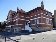
480 Newcastle St West Perth
Moved from City of Perth to Town of Vincent Change gazetted 29/5/07 Name change: 10/04/08 "Newcastle St School"
Newcastle Street Infants & Seniors School
West Perth School, St Johns C of E Schl,
Vincent
Metropolitan
Constructed from 1895 to 1928
| Type | Status | Date | Documents |
|---|---|---|---|
| Heritage List | Adopted | ||
| State Register | Registered | 14 Dec 2001 | HCWebsite.Listing+ListingDocument, HCWebsite.Listing+ListingDocument |
| Type | Status | Date | Documents |
|---|---|---|---|
| (no listings) |
| Type | Status | Date | Grading/Management | |
|---|---|---|---|---|
| Category | ||||
| Municipal Inventory | Adopted | 13 Nov 1995 | Category A | |
Fair to good condition
| Name | Type | Year From | Year To |
|---|---|---|---|
| Hillson Beasley | Architect | - | - |
| Charles Rosenthal | Architect | - | - |
| J M Tait | Architect | - | - |
Individual Building or Group
| Epoch | General | Specific |
|---|---|---|
| Original Use | EDUCATIONAL | Combined School |
| Present Use | EDUCATIONAL | Technical School |
| Style |
|---|
| Federation Arts and Crafts |
| Type | General | Specific |
|---|---|---|
| Wall | STONE | Limestone |
| Roof | TILE | Other Tile |
| Wall | BRICK | Common Brick |
| General | Specific |
|---|---|
| SOCIAL & CIVIC ACTIVITIES | Education & science |
This information is provided voluntarily as a public service. The information provided is made available in good faith and is derived from sources believed to be reliable and accurate. However, the information is provided solely on the basis that readers will be responsible for making their own assessment of the matters discussed herein and are advised to verify all relevant representations, statements and information.
Constructed from 1895 to 1902
Newcastle Street Government School is an unusual example of a large Government school that was originally built as a Church school. It is a fine example of the Federation Stripped Classical style and is a landmark on Newcastle Street. It informs of the history of development in the educational programs and facilities of the area and has associations with the school’s teaching staff and the generations of students.
A three storey red-brick building with a tiled hip roof and a central gable projecting forward on the symmetrical Newcastle St frontage. The gable features a triple arched ventilation detail. The ground level is of stone with arches over the now enclosed entranceways. The closely spaced double hung narrow windows at the second level have stone lintels. The top floor windows are double hung with four panes. The central pair of windows on the upper floor features multi-paned fanlights, making them taller than the other windows. Horizontal stucco bands feature above the first floor windows and below the windows on both the upper floors. Chimneys are brick with corbelled stucco decoration. Set back from Newcastle Street with hard surface in between. Several to facilitate the ongoing function of the place
Settlement took place in the area on the western end of Lake Henderson in the area of Cowle Street and along Newcastle Street from at least 1884. There was also considerable settlement to the south, between Newcastle Street and West Perth railway station. In 1878 Perth Town Lot Y262 was transferred to the Wesley and Methodist Church. Lot Y261 had been transferred to Geroge Dent. The Perth North Church of England Day School, also known as St John's Day School, was opened on the north side of the Newcastle Street site on 21 January 1889 to cater for the growth in the area. However, the buildig that it operated in was soon described as 'unsuitable'. It became a Government Assisted School in 1890 and in 1891 the Inspector reported: 'The building, which is only a temporary one, is very unsuitable for school purposes. At the time of visit there was very little apparatus of any kind in the school. The new school room, now in course of erection, will be of great help to the successful working of this school'. The new school building was constructed of brick with a verandah on the western side and brick toilets were constructed to the north-eastern part of the site. The footprint of this is shown on the 1897 PWD sewerage plants and the school was listed in the Wise's Post Office Directories from 1895/6. By 1893, enrolments had reached 114. The school could not exist without further help and the Government purchased the property and 'accepted some responsibility for the educational needs of a fast developing shanty town which had sprung up north of the railway line' (J. Rikkers). The Government school opened on 7 February 1895 as the Perth West Public School. The headmistress was Miss Laurina Reid and she was assisted by three part-time teachers. Enrolments in 1895 numbered 156. Miss Reid remained head teacher until 1900 when P.H Gladman took over. A new school was designed by Charles Rosenthal in 1895. He had been trained in Victoria and moved to WA in 1895 to a position with the Department of Railways and Public Works. During his time in WA he designed such buildings as the Free Public Library, Royal Mint and the Perth Law Courts. Tenders were called for new school's construction in 1895 and the contract (₤2,400) was awarded to Robert and Arthur Bunning. It was built in stone and brick and located on the north side of the existing school but it was not finished until July 1897. In March 1897 the name was changed to Newcastle Street School. That years plans were also drawn by Hillson Beasley for an Infant's School because of the pressure on the existing accommodation. The builders were Lake & Gurr and the cost was just over ₤1,292. The new Infants' School was opened on 5 September 1898. A galvanised iron building was also relocated from Subiaco State School and, although it was intended as temporary accommodation, it remained there for 30 years. A portion of Perth Town Lot Y262 was resumed by the Government from the Wesley Church in January 1898 at a cost of ₤375 to increase the size of the school's reserve and in 1900 further changes were made to the site when Reserve No. 3594 was cancelled and reserve 3765 was gazetted. This added about one acre of land to the school area but the grounds were still small. Eventually the Government was able to purchase some extra land in 1909 from the Wesley Trustees and this was added to the area. Hillson Beasley designed a new brick classroom in 1900 which was created by W.C Rose of Loftus Street, Leederville at a cost of ₤469. Enrolments continued to expand and extensions were carried out again in 1902 and 1907. Separate schools for boys and girls were formed in 1903, but they amalgamated as Newcastle Street State School in 1908. In 1910 Patrick M. Coughlan was the head teacher. Various additions were been made to the Newcastle Street School over the years, but enrolments decreased in the 1920's and some areas were not used. Others were in poor condition. The head teacher reported: 'It is in a very bad state indeed... The roof also is nearly rusted through. The appearance of the school is sordid and unpleasant.' it was estimated that it would cost ₤320 for renovations and a badly needed coat of paint. Nevertheless budget constraints meant that nothing was done until 1926 when, due to a lack of numbers (only 384 students) and the fact that there were five other schools close by, an annoucement was made that the school would be closed. Plans were drawn in 1927 for a July for a Junior Technical School by the Principal Architect, J.M. Tait. Alterations were made to the Senior and Infant's schools and a blacksmith's shop was added. Facilities were also included for woodwork and drawing classes. Tenders were called for the conversion in 1927 and it was carried out in 1928 by A. Woolhouse at a cost of ₤1,469. In 1929-30, the school became an annexe of the Technical Education Department (TAFE), and housed the Junior Technical School. The Junior Tech had been formed in 1917, and was previously accommodated in the Technical School Buildings on the Perth Boys' School site in St George's Terrace. By 1928, there was a shortage of accommodation at the St George's Terrace site and so the Newcastle Street annexe was opened. The Methodist Mission buildings on the nearby site on Charles Street was also later used by the Technical School. The Infant's School amalgamated with the State School on 1 May 1922 but was reinstated as a separate school, known as Newcastle Street Infants, in 1928. In 1927 plans had been drawn for a new Infant's School on the alnd acquired from the Wesley Church in 1909. It was constructed in 1928 by J.Lake at a cost of circa ₤3,771 and consisted of three classrooms, a verandah which could be used for teaching, a teacher's room, hat room and lavatories. A pavilion classroom was also added later. The new School was known as the first Infant's School and later as the Newcastle Street Junior Primary School. When Chrissie Samiotis was a student there in the 1930's, the school only went to Year 3 and she moved on to Highgate State School afterwards. It was the same for her own children Tony and Cath, although they moved on to Leederville State School. The School remained open until 1977 and so, by the time her third child, Evan, was ready to attend school it had been taken over by the Technical School and he went straight into Year 1 at Leederville. According to Chrissie, the school had changed little in the time between the 1930's and when her children went there. One of the few changes was that the original domestic science rooms had become the canteen and later it became the school's library. The building was later demolished to make way for new premises for the Department of Education and Training. Additions comprising a new classroom were carried out to the Perth Junior Technical College in 1934 by J. Shuttleworth, at a cost of ₤230 and a further addition was done the same year., again by A. Woolhouse, which cost ₤497. In 1953 two further classrooms were added to the site. More land was needed for the Technical School and in 1976 the Education Department purchased properties on the southern side of Prospect Place (Lots 2 and 3 of Perth Town Lot Y263), part of which later became a carpark. Further properties on the south side were added in 1978. The Newcastle Street Junior Technical School remained opened until around 2000, but once again there were few major changes in that period apart from the abovementioned changes in the Title, the change of the purpose of the land to the 'Technical School Site' in 1992 and in 1997, when most of the area was vested in the Minister for Training. The place was subsequently leased to Edith Cowan University and used by the Academy of Performing Arts (c.2001). More recently it has been used by the Central TAFE. It was listed on the Register of Heritage Places as a Permanent Entry in 2001.
Intact
This information is provided voluntarily as a public service. The information provided is made available in good faith and is derived from sources believed to be reliable and accurate. However, the information is provided solely on the basis that readers will be responsible for making their own assessment of the matters discussed herein and are advised to verify all relevant representations, statements and information.
482 - 496 Newcastle St West Perth
Street Numbers 482, 486, 490, 492, 494 & 496.
Vincent
Metropolitan
Constructed from 1898 to 1937
| Type | Status | Date | Documents |
|---|---|---|---|
| (no listings) |
| Type | Status | Date | Documents |
|---|---|---|---|
| RHP - Does not warrant assessment | Current | 27 Jun 2014 |
| Type | Status | Date | Grading/Management | |
|---|---|---|---|---|
| Category | ||||
| (no listings) | ||||
Newcastle Street Group is representative of the residential development of West Perth from the late nineteenth and early twentieth century, and contributes to the historic character of the area. It is a good example of a Federation Queen Anne style streetscape, showing a variation in stylistic elements and building size.
Newcastle Street Group is a continuous row of six houses located on the north side of Newcastle Street between Charles and Strathcona Streets in West Perth. All six buildings are single storey detached dwellings that face the street. Five of the houses were constructed in the Federation Queen Anne style and one was constructed in the Inter-War California Bungalow style (No. 486).
The row of six houses were constructed between 1898-1937. Three of the six houses continue to be used as private residences. Two residences are now used as a hostel for backpackers, and one residence is currently vacant although until recently was being used as a medical centre.
| Name | Type | Year From | Year To |
|---|---|---|---|
| James Hine | Architect | 1898 | - |
Individual Building or Group
| Epoch | General | Specific |
|---|---|---|
| Original Use | RESIDENTIAL | Other |
| Present Use | COMMERCIAL | Other |
| Present Use | RESIDENTIAL | Other |
| Style |
|---|
| Inter-War California Bungalow |
| Federation Free Style |
| General | Specific |
|---|---|
| DEMOGRAPHIC SETTLEMENT & MOBILITY | Land allocation & subdivision |
This information is provided voluntarily as a public service. The information provided is made available in good faith and is derived from sources believed to be reliable and accurate. However, the information is provided solely on the basis that readers will be responsible for making their own assessment of the matters discussed herein and are advised to verify all relevant representations, statements and information.

482-484 Newcastle St West Perth
Vincent
Metropolitan
Constructed from 1898
| Type | Status | Date | Documents |
|---|---|---|---|
| (no listings) |
| Type | Status | Date | Documents |
|---|---|---|---|
| RHP - Does not warrant assessment | Current | 27 Jun 2014 |
| Type | Status | Date | Grading/Management | |
|---|---|---|---|---|
| Category | ||||
| (no listings) | ||||
18411 Newcastle Street Group
Extensive alterations have been made to the property. The internal spaces have been altered to accommodate its use as a physiotherapy clinic, however some original fixtures such as skirting, ceiling roses and vents are intact. An extension has been added to the rear of the property, which added an exercise room featuring two pools. The original cellar is still accessible
| Name | Type | Year From | Year To |
|---|---|---|---|
| James Hine | Architect | - | - |
Individual Building or Group
| Epoch | General | Specific |
|---|---|---|
| Original Use | RESIDENTIAL | Single storey residence |
| Original Use | RELIGIOUS | Housing or Quarters |
| Present Use | VACANT\UNUSED | Vacant\Unused |
| Style |
|---|
| Federation Queen Anne |
| Type | General | Specific |
|---|---|---|
| Wall | BRICK | Common Brick |
| Roof | METAL | Corrugated Iron |
| General | Specific |
|---|---|
| SOCIAL & CIVIC ACTIVITIES | Religion |
| DEMOGRAPHIC SETTLEMENT & MOBILITY | Settlements |
This information is provided voluntarily as a public service. The information provided is made available in good faith and is derived from sources believed to be reliable and accurate. However, the information is provided solely on the basis that readers will be responsible for making their own assessment of the matters discussed herein and are advised to verify all relevant representations, statements and information.