Local Government
Vincent
Region
Metropolitan
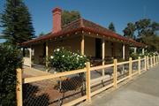
2 Dangan St Perth
Vincent
Metropolitan
Constructed from 1920
| Type | Status | Date | Documents |
|---|---|---|---|
| Heritage List | Adopted |
| Type | Status | Date | Documents |
|---|---|---|---|
| (no listings) |
| Type | Status | Date | Grading/Management | |
|---|---|---|---|---|
| Category | ||||
| Municipal Inventory | Adopted | 12 Sep 2006 | Category B | |
zUNKNOWN ZERO CODE
| Epoch | General | Specific |
|---|---|---|
| Present Use | Transport\Communications | Road: Other |
| Original Use | Transport\Communications | Road: Other |
| Type | General | Specific |
|---|---|---|
| Other | METAL | Other Metal |
| General | Specific |
|---|---|
| TRANSPORT & COMMUNICATIONS | Road transport |
This information is provided voluntarily as a public service. The information provided is made available in good faith and is derived from sources believed to be reliable and accurate. However, the information is provided solely on the basis that readers will be responsible for making their own assessment of the matters discussed herein and are advised to verify all relevant representations, statements and information.
Constructed from 1925
The extant old street signs are enamelled artefacts which demonstrate the variety of colourways and typefaces used in the suburb’s early street signage. Their significance is enhanced by remaining in location.
Early street signs were enamelled metal, in various colourways and with a variety of type faces. The signs are artefacts of their period and gain significance by remaining in location. Early street signs also remain at 189 Lake Street and 114 Bulwer Street. The street signs are fixed to the exterior of buildings.
Modern street signs are generally attached to metal poles erected specifically for the purpose. Early street signs were traditionally attached to the side of the residence which occupied the street corner site. Remaining signs attached to residences in the Town of Vincent are also located at No. 189 Lake Street (corner of Hope Street) and No. 114 Bulwer Street. Initially the poles used for the street signs were timber, cut from the tall trees of Western Australia's south-west, and in more recent times metal had been used. In some cases the poles used for the street signs were those previously erected for the tram and later the trolleybus wires of for other signage. It has been suggested that some areas of Perth had their street signs removed during World War II in case of an enemy invasion. It is not known whether this was the case in this district. According to Wise's Post Office Directories, No. 2 Dangan Street was constructed sometime before 1898 and was originally known as No. 10. In 1989 the house was occupied by William Jeffery. By 1915 both Jeffery and James McCraken wer listed as occupiers and in 1920 it was Mrs J. McCraken. In 1949 the resident listed was G.T Laudy.
High
This information is provided voluntarily as a public service. The information provided is made available in good faith and is derived from sources believed to be reliable and accurate. However, the information is provided solely on the basis that readers will be responsible for making their own assessment of the matters discussed herein and are advised to verify all relevant representations, statements and information.
34 & 36 Edward St Perth
Moved from City of Perth to Town of Vincent Change gazetted 29/5/07
Vincent
Metropolitan
Constructed from 1900
| Type | Status | Date | Documents |
|---|---|---|---|
| (no listings) |
| Type | Status | Date | Documents |
|---|---|---|---|
| (no listings) |
| Type | Status | Date | Grading/Management | |
|---|---|---|---|---|
| Category | ||||
| Perth Draft Inventory 99-01 | YES | 31 Dec 1999 | ||
| Name | Type | Year From | Year To |
|---|---|---|---|
| Cumpston, Louis Bowser | Architect | - | - |
Individual Building or Group
| Epoch | General | Specific |
|---|---|---|
| Original Use | RESIDENTIAL | Conjoined residence |
| Present Use | RESIDENTIAL | Conjoined residence |
| Type | General | Specific |
|---|---|---|
| Wall | BRICK | Rendered Brick |
| Roof | METAL | Corrugated Iron |
| Wall | BRICK | Painted Brick |
This information is provided voluntarily as a public service. The information provided is made available in good faith and is derived from sources believed to be reliable and accurate. However, the information is provided solely on the basis that readers will be responsible for making their own assessment of the matters discussed herein and are advised to verify all relevant representations, statements and information.
44-46 Edward St Perth
Moved from City of Perth to Town of Vincent Change gazetted 29/5/07
Vincent
Metropolitan
Constructed from 1900
| Type | Status | Date | Documents |
|---|---|---|---|
| (no listings) |
| Type | Status | Date | Documents |
|---|---|---|---|
| RHP - Assessed - Below Threshold | Current | 28 May 2004 |
| Type | Status | Date | Grading/Management | |
|---|---|---|---|---|
| Category | ||||
| Perth Draft Inventory 99-01 | YES | 31 Dec 1999 | ||
| Name | Type | Year From | Year To |
|---|---|---|---|
| Cumpston, Louis Bowser | Architect | - | - |
Individual Building or Group
| Epoch | General | Specific |
|---|---|---|
| Original Use | RESIDENTIAL | Conjoined residence |
| Present Use | COMMERCIAL | Bank |
| Style |
|---|
| Federation Free Classical |
| Type | General | Specific |
|---|---|---|
| Wall | BRICK | Painted Brick |
| Wall | BRICK | Rendered Brick |
| Roof | METAL | Corrugated Iron |
| General | Specific |
|---|---|
| SOCIAL & CIVIC ACTIVITIES | Community services & utilities |
This information is provided voluntarily as a public service. The information provided is made available in good faith and is derived from sources believed to be reliable and accurate. However, the information is provided solely on the basis that readers will be responsible for making their own assessment of the matters discussed herein and are advised to verify all relevant representations, statements and information.
54 Edward St Perth
Moved from City of Perth to Town of Vincent Change gazetted 29/5/07
Vincent
Metropolitan
| Type | Status | Date | Documents |
|---|---|---|---|
| (no listings) |
| Type | Status | Date | Documents |
|---|---|---|---|
| (no listings) |
| Type | Status | Date | Grading/Management | |
|---|---|---|---|---|
| Category | ||||
| Perth Draft Inventory 99-01 | YES | 31 Dec 1999 | ||
Individual Building or Group
| Epoch | General | Specific |
|---|---|---|
| Present Use | RESIDENTIAL | Single storey residence |
| Original Use | RESIDENTIAL | Single storey residence |
| Style |
|---|
| Federation Queen Anne |
| Type | General | Specific |
|---|---|---|
| Roof | METAL | Corrugated Iron |
| Wall | BRICK | Rendered Brick |
This information is provided voluntarily as a public service. The information provided is made available in good faith and is derived from sources believed to be reliable and accurate. However, the information is provided solely on the basis that readers will be responsible for making their own assessment of the matters discussed herein and are advised to verify all relevant representations, statements and information.
296 Fitzgerald St Perth
Cnr Fitzgerald & Glendower St
Carmel Corner
Vincent
Metropolitan
Constructed from 1914, Constructed from 1911
| Type | Status | Date | Documents |
|---|---|---|---|
| Heritage List | Adopted |
| Type | Status | Date | Documents |
|---|---|---|---|
| (no listings) |
| Type | Status | Date | Grading/Management | |
|---|---|---|---|---|
| Category | ||||
| Municipal Inventory | Adopted | 13 Nov 1995 | Category B | |
Individual Building or Group
| Epoch | General | Specific |
|---|---|---|
| Original Use | RESIDENTIAL | Conjoined residence |
| Present Use | COMMERCIAL | Office or Administration Bldg |
| Original Use | COMMERCIAL | Shop\Retail Store {single} |
| Style |
|---|
| Federation Italianate |
| Federation Bungalow |
| Type | General | Specific |
|---|---|---|
| Wall | BRICK | Painted Brick |
| Roof | METAL | Corrugated Iron |
| General | Specific |
|---|---|
| OCCUPATIONS | Commercial & service industries |
This information is provided voluntarily as a public service. The information provided is made available in good faith and is derived from sources believed to be reliable and accurate. However, the information is provided solely on the basis that readers will be responsible for making their own assessment of the matters discussed herein and are advised to verify all relevant representations, statements and information.
Constructed from 1911 to 1914
The place at No. 296 Fitzgerald Street is a representative example of an intact corner store in Federation Italianate style and Federation Bungalow style house, that makes a contribution to the streetscape and is a local landmark. Historically and socially it has been a focus of the area as a predominately retail outlet.
The single storey corner store with attached residence has an ornate parapet with ball finials and other decorative elements around the street fronts and corner truncation. The name of the building that was on the corner pediment has been gouged off, but can still be read to have been 'Carmel Corner'. The cantilevered bow verandah appears to be original. The brickwork has been painted. The single storey bungalow is of the most basic form of bungalow, with a large hipped roof, separate skillion verandah, and symmetrical distribution of openings. Prominent corner location- zero setbacks None apparent
Fitzgerald Street developed with a mixture of residential and retail/commercial premises, as expected of a major thoroughfare. Perth Town Lot Y285 was still vacant land in 1910, and was owned by George Throssell (1840-1910), a merchant, former Premier of Western Australia and Mayor of Northam. Throssell had arrived in Western Australia in 1850 with his parents on 'Scindian', the first of the convict transport ships. His father was a convict guard and became a police sergeant in Perth. George represented Northam in the West Australian Parliament from 1890 - 1904. He succeeded John Forrest as Premier in 1901 for a period of a little over three months before resigining and returning to the back bench. Throssell purchased the land on the corner of Fitzgerald Street and Glendower Street in 1902. It was situated very close to his Perth residence on nearby Throssell Street which was opposite Hyde Park. The house (No. 15 Throssell Street) still stands today and is listed on the Town's Municipal Heritage Inventory and the State Register of Heritage Places. George Throssell died in 1910 at his home in Northam as a result of a fall and the property in Fitzgerald Street was developed either by his executors or by a later owner. The residence and shop at No 296-298, on the corner of Fitzgerald and Glendower streets, was constructed around 1914. The building first appears in the Wises' Post Office Directories for 1914. The tenant of both the shop and the house at that time was recorded as draper Joseph Abramovich. In 1932, dressmaker Madame Gotlieb occupied both the shop and residence and in 1940 it was D. Nazarow, umbrella repairer. In 1949 the tenants were Mrs R. Ross 'frocks retail' at No. 296 and M. Segal, tailor at No. 298. As small retail premises were overtaken by larger shopping centres, the need for small businesses declined and the place became rundown. It has recently been restored and is currently used as offices.
Intact
This information is provided voluntarily as a public service. The information provided is made available in good faith and is derived from sources believed to be reliable and accurate. However, the information is provided solely on the basis that readers will be responsible for making their own assessment of the matters discussed herein and are advised to verify all relevant representations, statements and information.
176 Fitzgerald St, Randell, Palmerston & Stuart Sts Perth
Lake Henderson
Vincent
Metropolitan
Constructed from 1913, Constructed from 2003
| Type | Status | Date | Documents |
|---|---|---|---|
| Heritage List | Adopted | ||
| State Register | Registered | 08 May 2007 | HCWebsite.Listing+ListingDocument, HCWebsite.Listing+ListingDocument |
| Type | Status | Date | Documents |
|---|---|---|---|
| (no listings) |
| Type | Status | Date | Grading/Management | |
|---|---|---|---|---|
| Category | ||||
| Municipal Inventory | Adopted | 13 Nov 1995 | Category A | |
Robertson Park and Archaeological Sites has been built up over time in an ad hoc manner. There have been significant tree losses over time and some poor tree management in the past, but the remaining elements are well maintained generally and many of the archaeological sites noted in the documentary evidence are protected by being well covered. The park is in a constant state of change and upgrading by degree, with elements being replaced when required, tree surgery being carried out, and conservation works to items such as Lee Hop’s Cottage. Some Port Jackson Figs are in poor condition and have not responded to treatments including mulching and pruning. Some elements such as the grass court perimeter fencing are in poor condition. On the whole the place is in good condition.
| Library Id | Title | Medium | Year Of Publication |
|---|---|---|---|
| 11520 | Report of an archaeological survey of Robertson Park | Heritage Study {Other} | 2000 |
| 4902 | Conservation plan : Lee Hop's garden (site), Lee Hop's cottage, Halvorsen Hall : Robertson Park, North Perth / prepared for Town of Vincent by Hocking Planning & Architecture. | Heritage Study {Cons'n Plan} | 2000 |
| 4903 | Lee Hop's market garden : archaeological investigations to complement the conservation plan. | Heritage Study {Cons'n Plan} | 2000 |
Urban Park
| Epoch | General | Specific |
|---|---|---|
| Other Use | RELIGIOUS | Synagogue, Mosque or Temple |
| Other Use | EDUCATIONAL | Library |
| Original Use | PARK\RESERVE | Park\Reserve |
| Original Use | SOCIAL\RECREATIONAL | Other Community Hall\Centre |
| Original Use | FARMING\PASTORAL | Other |
| Other Use | OTHER | Other |
| Style |
|---|
| Federation Bungalow |
| Other Style |
| Type | General | Specific |
|---|---|---|
| Wall | BRICK | Common Brick |
| Roof | TILE | Ceramic Tile |
| General | Specific |
|---|---|
| DEMOGRAPHIC SETTLEMENT & MOBILITY | Immigration, emigration & refugees |
| SOCIAL & CIVIC ACTIVITIES | Sport, recreation & entertainment |
| DEMOGRAPHIC SETTLEMENT & MOBILITY | Aboriginal Occupation |
| SOCIAL & CIVIC ACTIVITIES | Cultural activities |
| SOCIAL & CIVIC ACTIVITIES | Religion |
| SOCIAL & CIVIC ACTIVITIES | Education & science |
| OCCUPATIONS | Rural industry & market gardening |
This information is provided voluntarily as a public service. The information provided is made available in good faith and is derived from sources believed to be reliable and accurate. However, the information is provided solely on the basis that readers will be responsible for making their own assessment of the matters discussed herein and are advised to verify all relevant representations, statements and information.
Constructed from 1903
Roberston Park is of considerable significance as an archaeological site, site of previous wetlands, a market garden site, a City Beautiful park project, and later developments including the tennis club and practice hall for the Perth City band. The place demonstrates a number of important phases in the district’s history, has associations with valued people and organisations of the district and has been an important open space which has influenced development in its vicinity.
Robertson Park is a product of the 'City Beautiful' movement. Occupying the site of the former Lake Henderson, within the streetblock bounded by Fitzgerald, Randell, Palmerston and Stuart Streets, it is an open grassed parkland with perimeter chain link fencing, that comprises grass tennis courts, along its northern side; tennis club room facilities, centrally located, the former bottleyard site in the south-east corner, and Lee Hop's cottage and Halvorsen Hall in the south west quadrant of the park. The facilities are set within parkland elements, although the park has not had a formal design coherence and co-ordination until the recent management plan. Archaeological investigations in the vicinity of Lee Hop's Cottage have demonstrated the nature of the market gardening activity that was undertaken on the foreshores of Lake Henderson and the nature of the layers of filling that produced the park formation. Parkland grassed, mature trees. Considerable
Robertson Park was established on the reclaimed area of Lake Henderson in the 1920s. Market gardening and farming activities were carried out on the area after the Lake was first drained in 1852 for this purpose. European market gardener James Fox, an ex-convict, worked the land there and by 1893, when it was sold to John Chipper, several farm buildings had been erected. it was sold to Dr Daniel Kenny in the 1890's, who built a four - roomed brick and iron cottage there in 1903. The European gardners were followed by Chinese market gardeners, who worked the area from about 1895 to 1928. Altogether around six Chinese men worked the 18 acres of market garden, some of them occupying the house built for Dr Kenny for their use and which became known as Lee Hop's Cottage. Later residents of the cottage included the parks first caretaker, James Imray. Conservation works on this cottage were completed in 2003 by Central TAFE students from Aboriginal Programs Centre. Folloiwng this it was leased by the Town of Vincent to Great Mates WA, an organisation which assists disadvantaged and at risk youth. In 1900, the Perth City Parks and Gardens Committee was set up to beautify the city. W. E. Bold, appointed Town Clerk in 1901, was a major advocate of the 'City Beautiful'. He convinced Perth City Council to purchase various Chinese market gardens for conversion into public parks and gardens. The Lake Henderson area was one of the former lakes that were purchased. Apart from Lot Y232, which had been obtained by the City of Perth in 1873 for a drainage reserve and was gazetted part of Reserve 21, Robertson Park itself was not gazetted a Reserve, but was vested in the City of Perth for municipal purposes. Robertson Park was established as a Council reserve in 1913 and development of the park began in the 1920s with the filling of the lake basin. In 1926, the first six lawn tennis courts, of a planned thirty four, were opened. They were situated at the Randell Street end of the Park. A tennis pavilion was also constructed in 1929 and regular tennis parties were held there. Local residents Reg Axford and Harold Mundy recalled sitting on the outside of the fence as young boys waiting for discarded cool drink bottles so that they could return them to the shop across the road and collect the refund. A recycling bottle factory operated on the south-eastern corner of the park and during an archeological dig around the year 2000 a number of early bottles were recovered. As the basin was filled, gardens and a children's playground were established on the Fitzgerald Street frontage, and a women's playing field. Although the main part of the lake basin was filled, the slope of the land around the outskirts of Robertson Park still attests to its origins as a lake. By 1937, City of Perth had acquired all the land fronting Fitzgerald Street, which left only the land on Palmerston Street in private hands. In 1940, a children's library was established in the house on the corner of Stuart and Fitzgerald streets. Another of the buildings on the Stuart Street frontage was used by the City of Perth Band. On 28 November 1970, a specially built facility for the Band, known as Halvorsen Hall, was opened by the Premier, Sir Charles Court, and Lord Mayor Sir Thomas Wardle. The hall was sited on the Fitzgerald Street frontage of the Park. The Band occupied the premises until December 1999, when they relocated to Queen's Gardens. In more recent times the hall has been occupied by a group of craftspeople. Robertson Park was increased in size between 1965 and 1987, with the acquisition of the Palmerston House site, Perth Jewish Association site, and the bottle yard. The buildings on the bottle yard have recently been demolished. In 1990 and again in 2004 there were extensive upgrades to the tennis facilities, which now attract players from a wide area and in 2006 an international seniors' competition was held there. In 1998, the Hyde Park Precinct Group put forward an improvement plan for Robertson Park, and the Lee Hop's Cottage and Halvorsen Hall were the subject of a conservation plan in 2000. Conservation work and recreation of the wetland areas began in 2005 and following that it became part of a Town of Vicent Wetlands Trail which links seven wetland areas in the region from Smith's Lake to Banks Reserve on the river in East Perth.
Moderate degree
This information is provided voluntarily as a public service. The information provided is made available in good faith and is derived from sources believed to be reliable and accurate. However, the information is provided solely on the basis that readers will be responsible for making their own assessment of the matters discussed herein and are advised to verify all relevant representations, statements and information.
20 - 26 Gladstone St Perth
Moved from City of Perth to Town of Vincent Change gazetted 29/5/07
Vincent
Metropolitan
Constructed from 1900
| Type | Status | Date | Documents |
|---|---|---|---|
| (no listings) |
| Type | Status | Date | Documents |
|---|---|---|---|
| (no listings) |
| Type | Status | Date | Grading/Management | |
|---|---|---|---|---|
| Category | ||||
| Perth Draft Inventory 99-01 | YES | 31 Dec 1999 | ||
Individual Building or Group
| Epoch | General | Specific |
|---|---|---|
| Present Use | RESIDENTIAL | Conjoined residence |
| Original Use | RESIDENTIAL | Conjoined residence |
| Style |
|---|
| Federation Queen Anne |
| Type | General | Specific |
|---|---|---|
| Roof | METAL | Corrugated Iron |
| Wall | BRICK | Face Brick |
This information is provided voluntarily as a public service. The information provided is made available in good faith and is derived from sources believed to be reliable and accurate. However, the information is provided solely on the basis that readers will be responsible for making their own assessment of the matters discussed herein and are advised to verify all relevant representations, statements and information.
23 Gladstone St Perth
Moved from City of Perth to Town of Vincent Change gazetted 29/5/07
Vincent
Metropolitan
| Type | Status | Date | Documents |
|---|---|---|---|
| (no listings) |
| Type | Status | Date | Documents |
|---|---|---|---|
| (no listings) |
| Type | Status | Date | Grading/Management | |
|---|---|---|---|---|
| Category | ||||
| Perth Draft Inventory 99-01 | YES | 31 Dec 1999 | ||
Individual Building or Group
| Epoch | General | Specific |
|---|---|---|
| Present Use | RESIDENTIAL | Single storey residence |
| Original Use | RESIDENTIAL | Single storey residence |
| Type | General | Specific |
|---|---|---|
| Roof | METAL | Corrugated Iron |
| Wall | BRICK | Face Brick |
This information is provided voluntarily as a public service. The information provided is made available in good faith and is derived from sources believed to be reliable and accurate. However, the information is provided solely on the basis that readers will be responsible for making their own assessment of the matters discussed herein and are advised to verify all relevant representations, statements and information.
107 Glendower St Perth
Vincent
Metropolitan
Constructed from 1900
| Type | Status | Date | Documents |
|---|---|---|---|
| (no listings) |
| Type | Status | Date | Documents |
|---|---|---|---|
| (no listings) |
| Type | Status | Date | Grading/Management | |
|---|---|---|---|---|
| Category | ||||
| (no listings) | ||||
Individual Building or Group
| Epoch | General | Specific |
|---|---|---|
| Original Use | RESIDENTIAL | Single storey residence |
| Present Use | RESIDENTIAL | Single storey residence |
| Type | General | Specific |
|---|---|---|
| Wall | BRICK | Common Brick |
| Other | TIMBER | Other Timber |
| Other | METAL | Pressed Metal |
| Roof | METAL | Corrugated Iron |
| General | Specific |
|---|---|
| DEMOGRAPHIC SETTLEMENT & MOBILITY | Settlements |
This information is provided voluntarily as a public service. The information provided is made available in good faith and is derived from sources believed to be reliable and accurate. However, the information is provided solely on the basis that readers will be responsible for making their own assessment of the matters discussed herein and are advised to verify all relevant representations, statements and information.
109 Glendower St Perth
Vincent
Metropolitan
Constructed from 1905
| Type | Status | Date | Documents |
|---|---|---|---|
| Heritage List | Adopted | 04 Dec 1998 |
| Type | Status | Date | Documents |
|---|---|---|---|
| (no listings) |
| Type | Status | Date | Grading/Management | |
|---|---|---|---|---|
| Category | ||||
| Municipal Inventory | Adopted | 21 Nov 2006 | Category B | |
Individual Building or Group
| Epoch | General | Specific |
|---|---|---|
| Original Use | RESIDENTIAL | Single storey residence |
| Present Use | RESIDENTIAL | Single storey residence |
| Style |
|---|
| Federation Arts and Crafts |
| Type | General | Specific |
|---|---|---|
| Roof | METAL | Corrugated Iron |
| Other | RENDER | Roughcast |
| Other | TIMBER | Other Timber |
| Wall | BRICK | Face Brick |
| General | Specific |
|---|---|
| DEMOGRAPHIC SETTLEMENT & MOBILITY | Settlements |
This information is provided voluntarily as a public service. The information provided is made available in good faith and is derived from sources believed to be reliable and accurate. However, the information is provided solely on the basis that readers will be responsible for making their own assessment of the matters discussed herein and are advised to verify all relevant representations, statements and information.
Constructed from 1905
The subject dwelling at No. 109 Glendower Street is a fine example of the Federation Arts and Craft style and makes a signficant contribution to the streetscape and character of the area.
The substantial single storey dwelling at No. 109 Glendower Street is a mirror image of No. 107 Glendower Street constructed in 1900 in the Federation Arts and Craft style. The dwelling features tuck-pointed face brick and heavily moulded stucco bands decorating the prominent arched front window. The projecting roof gable is half timbered with rough cast stucco infill and a bracketed frieze that extends under the eave line across the front. The dwelling has a return bullnosed verandah and the chimneys are topped by corbelled stucco. Garden setting behind street front fence. None apparent
Glendower Street was developed adjacent to Hyde Park. The houses shown on the 1897 PWD sewerage plan, fronting the park along what is now Glendower Street between Lake and William Strees, have all been replaced with later constructions. The residences along Glendower Street developed between 1900 and 1940. Glendower Street was first listed in Wise's Post Office Directories in 1898 when there were four houses (not numbered) listed between Palmerston and Fitzgerald Streets. The following year (1899) their numbers had doubled to eight but there were still no street numbers allocated. The subject dwelling was first listed in the Wise's Post Office Directories in 1898 with Mr Rober J Knox-Peden occupying the dwelling. In 1900 street numbers were listed for the first time, confirming that Knox - Peden did reside at No. 109. By 1915 the resident had changed to Thomas Wheatley and in 1925 it was R.F Hamilton. The 1935 listing indicated that Miss Grace Hamilton was in residence, possibly R. F Hamilton's daugther. In 1949, the last year of the Directories, Miss Hamilton was still the occupant suggesting that the Hamilton family resided at the subject place from 1925 to at least 1949.
Intact
This information is provided voluntarily as a public service. The information provided is made available in good faith and is derived from sources believed to be reliable and accurate. However, the information is provided solely on the basis that readers will be responsible for making their own assessment of the matters discussed herein and are advised to verify all relevant representations, statements and information.
123 Glendower St Perth
Vincent
Metropolitan
Constructed from 2000
| Type | Status | Date | Documents |
|---|---|---|---|
| Heritage List | Adopted |
| Type | Status | Date | Documents |
|---|---|---|---|
| (no listings) |
| Type | Status | Date | Grading/Management | |
|---|---|---|---|---|
| Category | ||||
| Municipal Inventory | Adopted | 12 Sep 2006 | Category B | |
| Name | Type | Year From | Year To |
|---|---|---|---|
| David Hillam | Architect | 2000 | - |
Individual Building or Group
| Epoch | General | Specific |
|---|---|---|
| Original Use | RESIDENTIAL | Conjoined residence |
| Present Use | RESIDENTIAL | Conjoined residence |
| Style |
|---|
| Late 20th-Century Late Modern |
| Type | General | Specific |
|---|---|---|
| Wall | CONCRETE | Concrete Slab |
| Roof | METAL | Steel |
| Wall | GLASS | Glass |
This information is provided voluntarily as a public service. The information provided is made available in good faith and is derived from sources believed to be reliable and accurate. However, the information is provided solely on the basis that readers will be responsible for making their own assessment of the matters discussed herein and are advised to verify all relevant representations, statements and information.
Constructed from 2000
The duplex, at 123 Glendower Street, is a fine example of the Late Modern style. It was commended in the RAIA (WA Chapter) Awards - Multi Residential program in 2000.
This late modern duplex dwelling comprises residences with two floor levels. The upper floor contains four bedrooms and two bathrooms in each duplex half with the living areas accommodated on the lower level. The building has carports at ground level, under a steel framed cantilever roof. The first floor walls extend to two stories high in steel framed glass panels and concrete panels with a triangular concrete slab wing dividing the concrete deck. The roof is a skillion sloping from the front to the rear. High steel rail gates- driveways into carports None apparent
Glendower Street was developed adjacent to Hyde Park. The houses shown on the 1897 PWD sewerage plan, fronting the Park along what is now Glendower Street between Lake and William Streets, have all been replaced with later constructions. The majority of residences along Glendower Street were constructed between 1900 and 1940. A weatherboard bungalow was built at No. 123 Glendower Street in 1916, for A. McDonald and the Wise's Post Office Directories indicated that the first tenant was J.H Schutts, a carrier. In 1935 the occupant was Mrs Gladys Smith and in 1949, the last year of the Directories, it was Mrs Alice Reid. Planning Approval for the demolition of the original single storey timber dwelling was issued in 1998 and subsequently the original building was removed for the new development which now occupies the site. No. 123 Glendower Street is a modern duplex designed by David Hillam Architects and erected in 1999 by CME Constructions. It was designed by David Hilliam for his own family who occupy one duplex half which is a mirro image of 123A. The place was commended in the Multi Residential category of the RAIA (WA Chapter) architectural awards in 2000 because of its style and fun-loving group.
High
| Name | Type | Year From | Year To |
|---|---|---|---|
| David Hillam | Architect | - | - |
This information is provided voluntarily as a public service. The information provided is made available in good faith and is derived from sources believed to be reliable and accurate. However, the information is provided solely on the basis that readers will be responsible for making their own assessment of the matters discussed herein and are advised to verify all relevant representations, statements and information.
15 Glendower St Perth
Cnr Glendower & Irene St
Triplex
Vincent
Metropolitan
Constructed from 1940
| Type | Status | Date | Documents |
|---|---|---|---|
| Heritage List | Adopted |
| Type | Status | Date | Documents |
|---|---|---|---|
| (no listings) |
| Type | Status | Date | Grading/Management | |
|---|---|---|---|---|
| Category | ||||
| Municipal Inventory | Adopted | 13 Nov 1995 | Category B | |
Individual Building or Group
| Epoch | General | Specific |
|---|---|---|
| Original Use | RESIDENTIAL | Single storey residence |
| Present Use | RESIDENTIAL | Single storey residence |
| Style |
|---|
| Inter-War Art Deco |
| Type | General | Specific |
|---|---|---|
| Roof | TILE | Other Tile |
| Wall | BRICK | Common Brick |
| Wall | BRICK | Rendered Brick |
| General | Specific |
|---|---|
| DEMOGRAPHIC SETTLEMENT & MOBILITY | Settlements |
This information is provided voluntarily as a public service. The information provided is made available in good faith and is derived from sources believed to be reliable and accurate. However, the information is provided solely on the basis that readers will be responsible for making their own assessment of the matters discussed herein and are advised to verify all relevant representations, statements and information.
Constructed from 1940
The triplex at No. 15 Glendower Street is a good example of the Interwar Art Deco style of architecture which, as a corner property, contributes to the streetscape and character of the area.
Three dwellings, with the corner dwelling orientated towards Glendower Street and Hyde Park, and the others with entrances from Irene Street. The brick and tile building exhibits Art Deco elements such as walls rendered in the style of ashlar block work, bubble glass windows and slab awnings over the windows. The corner dwelling has a stepped pediment façade and curved verandah with concrete column supports. The Irene Street dwellings each have a small entrance porch. The property is defined by a low brick wall that curves around the corner. The place is setback from both streets behind a low face brick wall. The setback area has a number of mature shrubs that obstruct views of the place. None apparent
Glendower Street was developed adjacent to Hyde Park. The houses shown on the 1897 PWD sewerage plan, on the southern side facing the Park along what is now Glendower Street between Lake and William streets, have all been replaced with later constructions. The residences on Glendower Street developed between 1900 and 1940. There was a cottage on the corner of Glendower and Irene streets in 1897, but this place did not appear in the City of Perth Rate Books by 1930. Those residences in the section between William and Throssell streets facing the park became more attractive following the upgrading of Hyde Park (which had previously been known as Third Swamp.) Originally this wetland has been an Aboriginal hunting and camping area and it was developed as Hyde Park from 1898 onwards. Two lakes were developed with a causeway and an island in the middle and shelter sheds. picnic areas, two playgrounds for children (many of the locals also climbed the trees or made cubbies in those shrubs and trees with low hanging branches) and a rotunda were all added in subsequent years. Glendower Street was first listed in Wise's Post Office Directories in 1898 when there were four houses (not numbered) listed between Palmertson and Fitzgerald Street. The following year (1899) their numbers had doubled to eight but there were still no numbers allocated. It is believed that the first residence west of Irene Street and facing the park was No 33, an 1890s dwelling occupied by George B Glossop and it appears that Mary Glossop lived next door shorlty after. In 1910 Wise's Post Office Directories listed Mrs Mary Glossop as the resident of No. 15 and George Glossop at No. 33 and the 1920 edition indicated that they were both still there. By 1930 No. 15 was occupied by Railton T. Street but George Glossop was still at No. 33 and he remained there until at least until 1949 when the Directories ceased. In 1937 Edward J. King was shown as being in residence at No. 15 but the property was not listed again in Glendower Street. In 1940 a triplex was under construction on the corner of Irene Street. It was owned by Mendel Brown, and in 1941 it was as 3 to 7 Irene Street. The occupants at the time were Mrs T. Goster, Mrs Helen Elliot and Mrs Sarah Brown, who was possibly a relation of Mendal Brown.
Intact
This information is provided voluntarily as a public service. The information provided is made available in good faith and is derived from sources believed to be reliable and accurate. However, the information is provided solely on the basis that readers will be responsible for making their own assessment of the matters discussed herein and are advised to verify all relevant representations, statements and information.
4-10 Grant St Perth
Vincent
Metropolitan
Constructed from 1906
| Type | Status | Date | Documents |
|---|---|---|---|
| Heritage List | Adopted |
| Type | Status | Date | Documents |
|---|---|---|---|
| (no listings) |
| Type | Status | Date | Grading/Management | |
|---|---|---|---|---|
| Category | ||||
| Classified by the National Trust | Classified | |||
| Register of the National Estate | Nominated | 23 Apr 1991 | ||
| Municipal Inventory | Adopted | 13 Nov 1995 | Category B | |
Individual Building or Group
| Epoch | General | Specific |
|---|---|---|
| Original Use | RESIDENTIAL | Terrace housing |
| Present Use | RESIDENTIAL | Terrace housing |
| Type | General | Specific |
|---|---|---|
| Roof | METAL | Corrugated Iron |
| Wall | BRICK | Common Brick |
| General | Specific |
|---|---|
| DEMOGRAPHIC SETTLEMENT & MOBILITY | Settlements |
| OUTSIDE INFLUENCES | Depression & boom |
This information is provided voluntarily as a public service. The information provided is made available in good faith and is derived from sources believed to be reliable and accurate. However, the information is provided solely on the basis that readers will be responsible for making their own assessment of the matters discussed herein and are advised to verify all relevant representations, statements and information.
Constructed from 1906
The terrace group at 4-10 Grant Street is one of the few single storey Federation Georgian style terraces remaining in Western Australia. The terraces were built for the owner, Mark Day, who occupied the largest unit. These modest places neighboured the Highgate Primary School and were very close to public transport. The terrace formed a similar function to the flats of the Interwar period. The terrace demonstrates a pattern of settlement no longer practiced.
Four modest single storeyed attached dwellings in the Federation Georgian style, reminiscent of the pre Goldboom era. No 4 has a wider frontage than the other three, which have similar width frontages. No 4 has a central front door with a room either side, whereas the others are single fronted. The terraces are of brick construction with dividing firewalls. The roof is hipped on its free ends and stepped in the middle. There are separate skillion and bullnose verandahs. The Federation Georgian style is very rare in Western Australia as the Georgian style is more common to the Old Colonial and Victorian eras of which little physical evidence remains. 4-10 Grant St are very late examples of the use of this style. High front brick wall None apparent
Grant Street is a small 'no through ' road running from Bulwer Street to the rear of the Highgate Primary School. The terraces at Nos. 4-10 were built on the eastern side of the street in 1906 for Mark Day. The dwelling at No. 4 with a wider frontage and greater depth than the other three had the rear of four separate blocks bordering it on the Bulwer Street. It was initially occupied by the owner himself. In 1906, No. 6 was vacant, and police constable John Sergeant, and ironmonger Mark Keddy occupied No 8 and No 10 respectively. The attraction of the area for the tenants would have been the transport facilities (the Beaufort Street trams had been operating since the early 1900's), although many preferred to walk into the City; and the existence of the school at the end of the street. Highgate School although built in 1895, had already expanded with a separate infant's scholl being established in 1900. Churches of both the Roman Catholic and Anglican denominations were also close by (Sacred Heart and St Albans) and a shopping strip was beginning to develop along Beaufort Street. According to Wise's Post Office Directories in 1915, Mark Day was no longer in residence. The tenants at this time were Ernest Haigh (4), George McCartney Allday (6), Mrs Mary Haynes (8) and Thomas W. Ball (10). There were no other houses on the east side of the street, and only two on the west side at this time. By 1925 there were eight houses altogether in the street and No. 4 was occupied by Albert E. Serrell, No. 6 by William Osborne, No. 8 by Reginald A. Eastwood and No. 10 by Frederick Washborne. In 1949 William Osborne was still at No. 6, but the other occupants had changed: Edward Guy at No. 4, Alex Clamp at No.8 and Arthur H. Green at No. 10.
Mostly intact
This information is provided voluntarily as a public service. The information provided is made available in good faith and is derived from sources believed to be reliable and accurate. However, the information is provided solely on the basis that readers will be responsible for making their own assessment of the matters discussed herein and are advised to verify all relevant representations, statements and information.
39 Knebworth Av Perth
Vincent
Metropolitan
Constructed from 1896
| Type | Status | Date | Documents |
|---|---|---|---|
| Heritage List | Adopted |
| Type | Status | Date | Documents |
|---|---|---|---|
| (no listings) |
| Type | Status | Date | Grading/Management | |
|---|---|---|---|---|
| Category | ||||
| Municipal Inventory | Adopted | 12 Sep 2006 | Category B | |
Individual Building or Group
| Epoch | General | Specific |
|---|---|---|
| Present Use | RESIDENTIAL | Single storey residence |
| Original Use | RESIDENTIAL | Single storey residence |
| Type | General | Specific |
|---|---|---|
| Other | TIMBER | Other Timber |
| Wall | BRICK | Face Brick |
| Roof | METAL | Corrugated Iron |
This information is provided voluntarily as a public service. The information provided is made available in good faith and is derived from sources believed to be reliable and accurate. However, the information is provided solely on the basis that readers will be responsible for making their own assessment of the matters discussed herein and are advised to verify all relevant representations, statements and information.
Constructed from 1896
The house at No 39 Knebworth Avenue is a good example of the Late Colonial Georgian style and the survivor of three identical neighbouring houses.
The bungalow is a simple symmetrical form with a hipped roof and separate skillion verandah, to the full width of the principal façade, supported on plain posts and bressemer. The walls are timber with a stepped plinth at sill level, double hung sashes and a central door with sidelights and fanlight. Previously one of three similar neighbouring houses, now lost. The front curtilage with its symmetrical pencil pines is enclosed by a palisade fence.
The dwelling is situated on the west side of Knebworth Avenue. This street developed as workers housing, tucked in behind William Street as it was redirected to join Clifton Street on the east side of Hyde Park. The 1953 MWSSDD sewerage plan shows No 39 Knebworth Avenue as one of three identical houses, numbered 31, 35 and 39. These same houses appear on the 1897 PWD sewerage plans. In 1896, a building application was submitted by T. A. Cooper for Lots 27 and 29 (No 31 and 39 Knebworth Ave). The residence at Lot 28 (No 35) may have already been under construction at this time. In 1915, the residences were occupied by Henry Philpott, Frank Kalman and Mrs Martha McCartney (No 39). The centre residence, No 35, has been replaced with a two-storey development.
Moderate to High
This information is provided voluntarily as a public service. The information provided is made available in good faith and is derived from sources believed to be reliable and accurate. However, the information is provided solely on the basis that readers will be responsible for making their own assessment of the matters discussed herein and are advised to verify all relevant representations, statements and information.
117 Lake St Perth
MHI indicates location as 117 Lake St
Vincent
Metropolitan
Constructed from 1910
| Type | Status | Date | Documents |
|---|---|---|---|
| Heritage List | Adopted |
| Type | Status | Date | Documents |
|---|---|---|---|
| (no listings) |
| Type | Status | Date | Grading/Management | |
|---|---|---|---|---|
| Category | ||||
| Municipal Inventory | Adopted | 13 Nov 1995 | Category B | |
Individual Building or Group
| Epoch | General | Specific |
|---|---|---|
| Present Use | RESIDENTIAL | Flats\Apartment Block |
| Original Use | INDUSTRIAL\MANUFACTURING | Other |
| Style |
|---|
| Federation Warehouse |
| Type | General | Specific |
|---|---|---|
| Other | GLASS | Glass |
| Roof | METAL | Steel |
| Wall | BRICK | Common Brick |
| General | Specific |
|---|---|
| OCCUPATIONS | Manufacturing & processing |
This information is provided voluntarily as a public service. The information provided is made available in good faith and is derived from sources believed to be reliable and accurate. However, the information is provided solely on the basis that readers will be responsible for making their own assessment of the matters discussed herein and are advised to verify all relevant representations, statements and information.
Constructed from 1910 to 1945
The former West Australian Boot Manufacturing Company structures are surviving elements of a major manufacturing operation and employer in the district. The place is a good example of robust Federation/Interwar Warehouse style. It has been adapted for contemporary residential development. The history of the place contributes to an understanding of the development of the area.
The Lake Street office building is a typical utilitarian factory and warehouse building of its time, with red brick pilasters and a stucco parapet into which the company's name is embossed. The two storey building is partially set below street level, so that the first floor is set just above street level and the ground floor appears as a basement, possibly for the storage of leather. Entry is gained through a door at street level. The door has a moulded stucco surround embellished by an entablature. The adjoining yard and warehouse has a grandly scaled brick wall the width of the street frontage, with a rendered base to the height of the office building's first floor level, rendered pilasters and a rendered capping with parallel label moulds running the length of the façade. The wider third bay of the wall houses sliding doors, solid to the bottom half and open in the upper half. The original factory building was a simple single storeyed brick building in Newcastle Street. The place has been converted into residential units. Zero street setback Extensive- adaptation to residential
The Western Australian Boot Manufacturing Company was established in 1907, in King Street, Perth under Managing Director William Robert Taplin. The other directors were Messrs Robinson, Edgar, Lilliam, Arcus, William Smight, Rochard Logan and William Dudney. The early sucess of the company was mainly due to Taplin's energy and expertise. In 1910, the Company purchased part of Lot N42 (Lots 1-4), 274 - 280 Newcastle Street, beside the Newcastle Club Hotel (now Arcadia). (The PWD sewerage plans, City of Perth & Suburbss' 1897 shown this block as the only one vacant along this portion of Newcastle Street.) A single storey brick factory with 4,000 sqaure feet (370sqm) of floor space was built on this block with a cellar at the rear for storing leather in a cool atmosphere. The factory itself was equipped was 'modern' machinery driven by a 5.25 horse-power motor. By 1913, the Company employed around fifty people and was producing over 100,000 pair of boots a year. It produced heavy and medium weight footwear for men, women and children, including the Harvester brand boot, which was popular in rural areas. The factory building was extended to the rear of the lot by the 1920s and the adjoining land at No. 117 Lake Street (Lots 5-9)was acquired. A two-storey building was constructed on the new site and in 1925 Wise's Post Office Directories listed the company on this site. No. 117 Lake Street was for the first time, indicating it was erected in 1925 or just before. The original single-storey factory building at No. 274 Newcastle Street and the new two-storey building at No. 127 Lake Street formed an L-shape around the Newcastle Club Hotel on the corner. The Boot Manufacturing Company occupied the premises until the 1980's. The buildings (a factory ,warehouse and office/showroom) were then vacant for some years until the late 1990s, when they were recycled for a residential development by the Giorgi Group. The Giorgi Group, which had owned the premises for some time, developed 16 townhouses in all, eight of qwhich were inside the shell of the old boot factory and 10 more on the adjoining site, which was formerly the Napoli Pasta Factory. The architect for the conversion was Brain Klopper of North Fremantle. The project recieved approval to go ahead in 1998 and was completed in 2000. This factory is one of several former factories and warehouses in the metropolitan area that have undergone a similar metamorphosis.
Façade and shell - highInternally - generally low
This information is provided voluntarily as a public service. The information provided is made available in good faith and is derived from sources believed to be reliable and accurate. However, the information is provided solely on the basis that readers will be responsible for making their own assessment of the matters discussed herein and are advised to verify all relevant representations, statements and information.
133-135 Lake St Perth
Vincent
Metropolitan
Constructed from 1897
| Type | Status | Date | Documents |
|---|---|---|---|
| Heritage List | Adopted |
| Type | Status | Date | Documents |
|---|---|---|---|
| (no listings) |
| Type | Status | Date | Grading/Management | |
|---|---|---|---|---|
| Category | ||||
| Municipal Inventory | Adopted | 21 Nov 2006 | Category B | |
Individual Building or Group
| Epoch | General | Specific |
|---|---|---|
| Present Use | RESIDENTIAL | Single storey residence |
| Original Use | RESIDENTIAL | Single storey residence |
| Original Use | COMMERCIAL | Shop\Retail Store {single} |
| Present Use | COMMERCIAL | Shop\Retail Store {single} |
| Type | General | Specific |
|---|---|---|
| Wall | BRICK | Rendered Brick |
| Roof | METAL | Corrugated Iron |
This information is provided voluntarily as a public service. The information provided is made available in good faith and is derived from sources believed to be reliable and accurate. However, the information is provided solely on the basis that readers will be responsible for making their own assessment of the matters discussed herein and are advised to verify all relevant representations, statements and information.
Constructed from 1897
The shop and attached house at Nos. 133 - 135 Lake Street demonstrate the character and scale of late 1890’s inner city development, when the Late Colonial Georgian models and styles were as prelevent as the Federation styles which came with the Gold Boom era.
The shop and attached house at Nos. 133 - 135 Lake Street is built hard onto the two street boundaries, with a truncated corner entry and facetted roof and protrudes from the recessed dwelling of which it is attached. The multipaned shop front windows are symmetrical about the corner. Low brick fences Filigree brackets, canvas awning.
Lake Street was so named because it originally terminated in a lake at each end. At its southern end was Lake Kingsford (the site of the Perth Railway Station) and at the northern end was Hyde Park. The shop and attached house were erected on the corner of Lake and Church streets at much the same time as Bakers Terrace (Nos. 156-184 Lake Street). They appear on the 1897 PWD sewerage plans, 'City fo Perth & Suburbs.' The City of Perth Rate books showed the owner as B. H Barnett. The builder, H Wells was still in residence in 1898 suggesting that some of the places were still under construction at that stage. The following year, 1898, the resident was Mrs H. Crossley at No. 135 (then numbered 199) and George Exley and Madame Exley, a clairvoyant, next doot at No. 133 (then numbered 197). At that time an orange grove still existed in Lake Street further north of the subject. In 1905, Mrs H. Lilllyeman, a grocer was occupied No. 135 (then numbered No. 199) and James Guest was at No. 133 (then numbered No. 197). In 1908 the numbers change to how they appear today with a Mr William Coy residing at the house at No. 133 and Arthur Lilleyman, a grocer at No. 135. In 1905 the other occupations listed for those residences north of Newcaslte Street (and within the present Town of Vincent) included builder, teacher, carpenter and policeman plus the Newcastle Club Hotel which was on the corner of Newcastle Street. In 1915 William Conroy was running the grocery store and Richard Hider occupied the residence at No. 135. Then throughout the 1920's the occupants of the shop and house attached changed on a regular basis. Some of the longer term residents include Mr W H Soutar who was the storekeeper of No. 135 Lake Street from 1923 until 1933. Mr John Joyce resides at the dwelling at No. 133 from 1920 until 1925. A similarly high turn over of residency was evident in the 1930's with a Mr Jack Kyriackis occupying the house at No. 133 from 1934 until 1937 and a Mr Stanley Biffen operating a grocery store from No. 135 during the same period. In the 1940's Mr James Harris resides at No. 133 Lake Street from 1942 until 1948 and Mr Albert Lockyer operates as a grocer from No. 133 between 1938 and 1945. In 1949 the occupants were George Haldupis (No. 133) and S. Gelvais, grocer, at No. 135. Work was carried out to upgrade the premises in 1996 when it was operating at PJY's lunch bar. After several changes in ownership, 'Rent a Ten't opened a business at the premises in 2002.
High
This information is provided voluntarily as a public service. The information provided is made available in good faith and is derived from sources believed to be reliable and accurate. However, the information is provided solely on the basis that readers will be responsible for making their own assessment of the matters discussed herein and are advised to verify all relevant representations, statements and information.

156-184 Lake St Perth
Vincent
Metropolitan
Constructed from 1897
| Type | Status | Date | Documents |
|---|---|---|---|
| Heritage List | Adopted | ||
| State Register | Registered | 06 Sep 1996 | HCWebsite.Listing+ListingDocument, HCWebsite.Listing+ListingDocument |
| Type | Status | Date | Documents |
|---|---|---|---|
| (no listings) |
| Type | Status | Date | Grading/Management | |
|---|---|---|---|---|
| Category | ||||
| Register of the National Estate | Nominated | 17 May 1991 | ||
| Register of the National Estate | Indicative Place | |||
| Classified by the National Trust | Classified | 01 Apr 1991 | ||
| Municipal Inventory | Adopted | 13 Nov 1995 | Category A | |
Precinct or Streetscape
| Epoch | General | Specific |
|---|---|---|
| Original Use | RESIDENTIAL | Terrace housing |
| Original Use | RESIDENTIAL | Two storey residence |
| Present Use | RESIDENTIAL | Terrace housing |
| Style |
|---|
| Federation Filigree |
| Type | General | Specific |
|---|---|---|
| Wall | BRICK | Face Brick |
| Roof | METAL | Corrugated Iron |
| General | Specific |
|---|---|
| DEMOGRAPHIC SETTLEMENT & MOBILITY | Settlements |
| OUTSIDE INFLUENCES | Depression & boom |
This information is provided voluntarily as a public service. The information provided is made available in good faith and is derived from sources believed to be reliable and accurate. However, the information is provided solely on the basis that readers will be responsible for making their own assessment of the matters discussed herein and are advised to verify all relevant representations, statements and information.
Constructed from 1897
Baker’s Terrace is of considerable significance as a fine example of Federation Filigree style residential terraces of 1897 period. It is the longest (15) terrace of its type in Western Australia and makes a substantial contribution to the streetscape and character of the area. It is integral within the residential subdivision developed by William Brookman and the Colonial Finance Company that demonstrates the social hierarchy and way of life of the time.
Bakers Terrace comprises fifteen, two-storeyed terrace dwellings with verandahs at each level. The central section and both ends have parapets with stucco decoration and ball finials. Over the central dwelling is a pediment inscribed with the name and date of the terrace. Originally face brick with tuck-pointing, stucco bands and cast iron friezes and balustrades, the individual dwellings have been modified to varying extents, with some retaining these original features. Minimal front setbacks and various combinations of gardens or paving behind a variety of front fences. Various- considerable interior modifications and refurbishments
Thomas Mews was assigned Suburban Lot 28 in 1834, part of the land that the subject places were built on. In May 1895 a property investment company, the Colonial Finance Corporation purchased part of Lot 28 for a housing estate. This estate, part of which was reclaimed from Lake Thompson, was bounded by Lake Street on the west, Cicely Street (Robinson Avenue) on the north side Forbes Street on the south and Wellman Street to the east. The latter two streest as well as Brookman (named after William Brookman, a mine developer and Mayor of Perth form 1900 - 1901) and Moir (another large investor in the company) were created during the development of the estate. In all 75 houses were built on the estate and these included the single-storey duplex dwellings on Brookman and Moir Streets, together with the single residence at 40 Forbes Rd, and the two-storey terraces at 156-184 Lake Street, known as 'Baker's Terrace'. Baker's Terrace which is shown on the 1897 PWD sewerage plans 'City of Perth & Suburbs' is a row of fifteen two-storey terrace houses, which was built on Lake Street for middle class residents. There were also twenty-nine duplex pairs on Moir and Brookman Streets and the single residence on Forbes Street, which were constructed for working class occupants. The duplex pairs were of more modest size and design than the terrace houses, but standard of workmanship was similarly high. The estate reflected the social mores of the time, with the middle class residences such as Bakers Terrace in a prominent position and the working class homes in the smaller streets behind. Although the occupations of the residents in 1900 (see below) only partially reflected this distinction. The practice of having factories interspersed with housing was continued in this area. For example the West Australian Boot Manufacturing Company at No. 117 Lake Street and around the corner in Newcastle Street, which employed many locals amongst its 50 workers. The subject houses were listed in Wise's Post Office Directories at Nos. 216 - 242 from 1897 until 1908 when they were renumbered as they are today. The City of Perth rate book listings for Baker's Terrace, show some of the occupations of the residents as importer, hotel proprietor, contractor, traveller, widow, clairvoyant and labourer. According to the Wise's Post Office Directories there were also E & J Myers at No. 216 (a larger block than the rest of the terrace) in 1899 who were importers, In 1901 they were listed as coridal manufacters, and at No. 218 as well as No. 216. The Colonial Finance Corporation retained owenrship of Baker's Terrace until 1921 when the houses were sold to Hyan Yester. In the 1960's the houses were sold off to individuals. By this time inner city living had become unfashionable and, therefore unpopular with the affluent. Many of the residents were post World War II immigrants as inexpensive inner city housing was an attractive option for them. From the late 1970's on fashions changed and young affluent professionals moved in, renovating and restoring the original homes, By 1995 a number of the houses in Baker's Terrace had undergone restoration and most had been extended at the rear while still retaining the decorative ceiling roses and other original features.
Mostly intact or redeemable
This information is provided voluntarily as a public service. The information provided is made available in good faith and is derived from sources believed to be reliable and accurate. However, the information is provided solely on the basis that readers will be responsible for making their own assessment of the matters discussed herein and are advised to verify all relevant representations, statements and information.
165-167 Lake St Perth
Vincent
Metropolitan
Constructed from 1903
| Type | Status | Date | Documents |
|---|---|---|---|
| (no listings) |
| Type | Status | Date | Documents |
|---|---|---|---|
| (no listings) |
| Type | Status | Date | Grading/Management | |
|---|---|---|---|---|
| Category | ||||
| (no listings) | ||||
18024 Lake Street Orange Orchard Estate semi-detached
Individual Building or Group
| Epoch | General | Specific |
|---|---|---|
| Present Use | RESIDENTIAL | Terrace housing |
| Original Use | RESIDENTIAL | Terrace housing |
| Style |
|---|
| Federation Filigree |
| Type | General | Specific |
|---|---|---|
| Wall | BRICK | Face Brick |
| Wall | BRICK | Rendered Brick |
| Roof | METAL | Corrugated Iron |
| General | Specific |
|---|---|
| DEMOGRAPHIC SETTLEMENT & MOBILITY | Settlements |
This information is provided voluntarily as a public service. The information provided is made available in good faith and is derived from sources believed to be reliable and accurate. However, the information is provided solely on the basis that readers will be responsible for making their own assessment of the matters discussed herein and are advised to verify all relevant representations, statements and information.
165-185 Lake St Perth
House numbers 165-167 (Ensenada & Coronada), 169-173, 175-179, 181-185
Ensenada
Vincent
Metropolitan
Constructed from 1903
| Type | Status | Date | Documents |
|---|---|---|---|
| Heritage List | Adopted |
| Type | Status | Date | Documents |
|---|---|---|---|
| RHP - Does not warrant assessment | Current | 25 Nov 2011 |
| Type | Status | Date | Grading/Management | |
|---|---|---|---|---|
| Category | ||||
| Municipal Inventory | Adopted | 13 Nov 1995 | Category A | |
Individual Building or Group
| Epoch | General | Specific |
|---|---|---|
| Present Use | RESIDENTIAL | Conjoined residence |
| Present Use | RESIDENTIAL | Two storey residence |
| Present Use | RESIDENTIAL | Terrace housing |
| Original Use | RESIDENTIAL | Conjoined residence |
| Present Use | RESIDENTIAL | Single storey residence |
| Original Use | RESIDENTIAL | Terrace housing |
| Original Use | RESIDENTIAL | Single storey residence |
| Original Use | RESIDENTIAL | Two storey residence |
| Style |
|---|
| Federation Filigree |
| Federation Italianate |
| Type | General | Specific |
|---|---|---|
| Other | TIMBER | Other Timber |
| Wall | BRICK | Common Brick |
| Roof | METAL | Corrugated Iron |
| Wall | BRICK | Rendered Brick |
| General | Specific |
|---|---|
| DEMOGRAPHIC SETTLEMENT & MOBILITY | Settlements |
This information is provided voluntarily as a public service. The information provided is made available in good faith and is derived from sources believed to be reliable and accurate. However, the information is provided solely on the basis that readers will be responsible for making their own assessment of the matters discussed herein and are advised to verify all relevant representations, statements and information.
Constructed from 1903
The semi-detached pair (Ensenada & Coronada) at 165-167 are a fine and unusual example of a Federation Filigree terrace pair. It makes a significant contribution to the streetscape particularly with the considerable plantings in the front garden. It demonstrates changes in the social status of the area. The semi-detached pairs, 169-173, 175-179 & 181-185 Lake Street, are good and representative examples of the Federation Bungalow style that contribute to the streetscape and character of the area. The places have associations with the neighbouring Brooking Park Estate.
The pair of two storeyed houses (165-167) was built in 1902 opposite the similarly styled Baker's Terrace. The building has a parapet with balustrading and a pediment over each dwelling bearing the date and the names "Ensenada" and "Coronada" respectively. The three pairs of single storeyed semi-detached dwellings (169-173, 175-179 & 181-185) have a turned bullnose verandah supported by stop chamfered posts with timber brackets. The gables have finials and are half timbered with roughcast infill and a timber bracketed frieze. A small gablet has a timber ventilator inset. Each has a brick chimney with a corbelled stucco trim. The casement windows have square lights above. The places are setback from the street, behind fences, but are mostly obscured by dense and inappropriate tree plantings. Extensions at the rear of Coronado- also top storey alterations and roof intrusions.
The residences at Nos. 165-167 Lake Street were built in 1902, and were given the names of 'Ensenada' and 'Coronada'. They were built on the Brooking Park Estate which was developed in 1896. The estate was named for surveyor J. S. Brooking, whose home 'Lakeside' at No. 106 Palmerston Street was on part of the Estate. The Estate included Suburban Lot 1, on the corner of Lake and Brisbane Streets, on which an orange orchard and associated residence were situated. (Nearby Orange Avenue was so named because of this.) This orchard was planted by early settler, Richard Gallop, who was granted four acres in 1885 on land between Palmerston and Lake streets. Gallop who arrived in Western Australia in 1829 as an indentured labourer, also grew vegetables on the site. In the estate subdivision, the orange orchard and residence were sited on Lots 9-17 on Lake Street, between Stuart and Hope streets, and were offered for sale as one parcel. The existing residence, on Lot 17 (shown on hte 1897 'City of Perth & Suburbs Sewerage Plans', 1897), then No. 239 was shown in the Wise's Post Office Directories as being occupied by Frederick Sandeman in 1901. It was later numbered 163 Lake Street. Four semi-detached pairs and one detached dwelling (Nos. 165-187 Lake Street) were built on the remainder of the site, replacing the orange orchard. In 1902, the land was owned by William Henry Vincent and was recorded as vacant. By 1904, there were six residences completed: two numbered 227-229 (Nos. 165-167) and four numbered 231-241 (No. 169-179). No 243 (No. 181) was occupied by the contractor, Fred James Vincent (also referred to as James Fred) and the rest of the land was still vacant. William Henry Vincent came to WA from Victoria in 1899. He had worked in his father's building company in Victoria and the USA in the mid 1880s. In WA, the company, R. P. Vincent & Son, built the Supreme Court, extensions to Government House and Royal Perth Hospital. After his father's death, William Vincent also built the Horseshoe Bridge, and bought two brick companies. His other activities included terms as president of the Master Builder's Association, chairman of the Children's Hospital Board, Art Gallery Trustee, and member of the Weld Club. It is not known if the contractor, Fred James Vincent was a relative. The dwellings at Nos. 165-167 Lake Street, named Ensenada and Coronada, were originally occupied by a doctor and a retired person, and were valued at £47 each. They were the grandest of the four semi-detached residences in the group. Each have four bedrooms and a 10 metre long central hallway. In 1915, No. 165 was occupied by Mrs L. Allen and No. 167 by William Thomson and Charles Patterson. In 1932, both residences were listed as 'apartments', with No. 165 occupied by Mrs Rita Traynor and No. 167 by Mrs Milly Allen. The difference between apartments and a boarding house is not clear. It may have involved the provision, or not, of meals, but more likely 'apartments' was simply a more refined name for a boarding house. In the 1960s and 1970s, No. 165 was still operating as a boarding house and had become run down. In 1981, it was purchased as a private residence and restored. The work included the removal of parts of walls to open and brighten the interior. No. 167 was also purchased for restoration in 1981. The Chilean willows which largely block the view of the place were planted at this time by the owners to provide privacy to the lower floors while retaining the views from the balconies. Nos. 169-173, 175-179 & 181-185 are identical. When constructed they were valued at £39. No. 169-173 were occupied by a contractor and manager in 1904. In 1915, they were occupied by Mrs A. King and Myer Sharp. No. 181-185 were occupied by Thomas Kane and Meyer Jacobs in that year. The semi-detached pair situated between these two semi pairs (Nos. 175-179) has a narrower street frontage. In 1949, the last year of the Directories, the residents of the subject places were; No. 165 Mrs Trayer - apartments. No. 167 T.M Lynch, No. 169 Mrs Dalliston, No. 173 Paul Rispoli, No. 175 Mrs G. McLachlan, No. 179 Luke Vodanovic, No. 181 Mrs Ruby Ashton and No. 185 Leonard Mitchell. Stuart Street Reserve on south-west corner at the intersection of Lake and Stuart streets, oppostie the southern boundary o the original subdivision, is part of the Wetlands Trail begun in 2001 to highlight the series of original wetlands within the Town of Vincent.
Mostly intact (165-167)Intact (169-173, 175-179 & 181-185)
This information is provided voluntarily as a public service. The information provided is made available in good faith and is derived from sources believed to be reliable and accurate. However, the information is provided solely on the basis that readers will be responsible for making their own assessment of the matters discussed herein and are advised to verify all relevant representations, statements and information.
169-173 Lake St Perth
Vincent
Metropolitan
Constructed from 1903
| Type | Status | Date | Documents |
|---|---|---|---|
| (no listings) |
| Type | Status | Date | Documents |
|---|---|---|---|
| (no listings) |
| Type | Status | Date | Grading/Management | |
|---|---|---|---|---|
| Category | ||||
| (no listings) | ||||
18024 Lake Street Orange Orchard Estate semi-detached
Individual Building or Group
| Epoch | General | Specific |
|---|---|---|
| Present Use | RESIDENTIAL | Conjoined residence |
| Original Use | RESIDENTIAL | Conjoined residence |
| Type | General | Specific |
|---|---|---|
| Wall | BRICK | Rendered Brick |
| Roof | METAL | Corrugated Iron |
| Wall | BRICK | Face Brick |
| General | Specific |
|---|---|
| DEMOGRAPHIC SETTLEMENT & MOBILITY | Settlements |
This information is provided voluntarily as a public service. The information provided is made available in good faith and is derived from sources believed to be reliable and accurate. However, the information is provided solely on the basis that readers will be responsible for making their own assessment of the matters discussed herein and are advised to verify all relevant representations, statements and information.