Local Government
Broomehill-Tambellup
Region
Great Southern
Jasper St Broomehill
Broomehill Railway Station
Broomehill-Tambellup
Great Southern
| Type | Status | Date | Documents |
|---|---|---|---|
| (no listings) |
| Type | Status | Date | Documents |
|---|---|---|---|
| (no listings) |
| Type | Status | Date | Grading/Management | |
|---|---|---|---|---|
| Category | ||||
| Municipal Inventory | Adopted | 21 Nov 1996 | ||
06195 Broomehill Railway Station, Ficus & Ironbark Trees
Tree
| Epoch | General | Specific |
|---|---|---|
| Original Use | OTHER | Other |
This information is provided voluntarily as a public service. The information provided is made available in good faith and is derived from sources believed to be reliable and accurate. However, the information is provided solely on the basis that readers will be responsible for making their own assessment of the matters discussed herein and are advised to verify all relevant representations, statements and information.
The Ficus and Ironbark Trees at the Railway Station may be as old as 100 years. The trees may have been planted by school children or by hte Stationmaster.
These two trees are located near the Broomehill Railway Station. No one quite knows the age of the trees, or who planted them.
Very Good
This information is provided voluntarily as a public service. The information provided is made available in good faith and is derived from sources believed to be reliable and accurate. However, the information is provided solely on the basis that readers will be responsible for making their own assessment of the matters discussed herein and are advised to verify all relevant representations, statements and information.
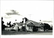
Jasper St Broomehill
Broomehill-Tambellup
Great Southern
Constructed from 1953
| Type | Status | Date | Documents |
|---|---|---|---|
| Heritage List | Adopted | 21 Nov 1996 |
| Type | Status | Date | Documents |
|---|---|---|---|
| RHP - To be assessed | Current | 12 Jul 2019 |
| Type | Status | Date | Grading/Management | |
|---|---|---|---|---|
| Category | ||||
| Municipal Inventory | Adopted | 21 Nov 1996 | ||
16818 Holland's Track
| Library Id | Title | Medium | Year Of Publication |
|---|---|---|---|
| 199 | History of the Holland Track. | Heritage Study {Other} | 1992 |
Historic site
| Epoch | General | Specific |
|---|---|---|
| Present Use | MONUMENT\CEMETERY | Monument |
| Original Use | MONUMENT\CEMETERY | Monument |
| Type | General | Specific |
|---|---|---|
| Wall | STONE | Other Stone |
| General | Specific |
|---|---|
| PEOPLE | Local heroes & battlers |
This information is provided voluntarily as a public service. The information provided is made available in good faith and is derived from sources believed to be reliable and accurate. However, the information is provided solely on the basis that readers will be responsible for making their own assessment of the matters discussed herein and are advised to verify all relevant representations, statements and information.
Constructed from 1953
Historic: the Memorial represents an association with explorers of the region.
The Holland Track Memorial faces North east, is surrounded by a small fence and is located on the main road through Broomehill, across from the Shire Offices (north).
The memorial was unveiled in February 1953, by Mr JF Hillman. It commemorates the epic journey of four Broomehill men from Broomehill to Coolgardie (some 300 miles through unexplored country). The members of this party; John Holland(leader), Rudolph Krakoeur (2IC), David Krakoeur and John Carmody. They left Broomehill April 15th 1893 and arrived in Coolgardie June 18th 1893. The memorial faces North east in the direction the men took.
Good
This information is provided voluntarily as a public service. The information provided is made available in good faith and is derived from sources believed to be reliable and accurate. However, the information is provided solely on the basis that readers will be responsible for making their own assessment of the matters discussed herein and are advised to verify all relevant representations, statements and information.
Cnr Journal & India Sts Broomehill
Broomehill-Tambellup
Great Southern
Constructed from 1892
| Type | Status | Date | Documents |
|---|---|---|---|
| Heritage List | Adopted | 21 Nov 1996 |
| Type | Status | Date | Documents |
|---|---|---|---|
| RHP - To be assessed | Current | 13 Aug 2004 |
| Type | Status | Date | Grading/Management | |
|---|---|---|---|---|
| Category | ||||
| Municipal Inventory | Adopted | 21 Nov 1996 | ||
12413 Broomehill Town Centre Precinct
Individual Building or Group
| Epoch | General | Specific |
|---|---|---|
| Original Use | Transport\Communications | Comms: Post or Telegraph Office |
| Present Use | Transport\Communications | Comms: Post or Telegraph Office |
| Type | General | Specific |
|---|---|---|
| Roof | METAL | Corrugated Iron |
| Wall | BRICK | Common Brick |
| General | Specific |
|---|---|
| TRANSPORT & COMMUNICATIONS | Mail services |
This information is provided voluntarily as a public service. The information provided is made available in good faith and is derived from sources believed to be reliable and accurate. However, the information is provided solely on the basis that readers will be responsible for making their own assessment of the matters discussed herein and are advised to verify all relevant representations, statements and information.
Constructed from 1892
The place demonstrates associations with early postal services in the Broome Hill district.
The Broomehill Post office is located in India Street, Broomhill. A similar Post Office building can be seen in Mount Barker, so it can be said that this design was used in other Post Office buildings. The Postmater's residence is to the rear of the building.
early records show that Eticup had an official Postmaster as ealry as 1879. The postal services were transferred to Broome Hill in 1889 and the post could be collected from JJ Garity's store prior to the current Post Office being built in 1892.
Extent of Original Fabric: 70%
Good
| Ref ID No | Ref Name | Ref Source | Ref Date |
|---|---|---|---|
| Broomehill Historical Society Records |
| Owner | Category |
|---|---|
| A & S Webster | Other Private |
This information is provided voluntarily as a public service. The information provided is made available in good faith and is derived from sources believed to be reliable and accurate. However, the information is provided solely on the basis that readers will be responsible for making their own assessment of the matters discussed herein and are advised to verify all relevant representations, statements and information.
Cnr Journal & India Sts Broomehill
Broomehill-Tambellup
Great Southern
| Type | Status | Date | Documents |
|---|---|---|---|
| (no listings) |
| Type | Status | Date | Documents |
|---|---|---|---|
| RHP - To be assessed | Current | 13 Aug 2004 |
| Type | Status | Date | Grading/Management | |
|---|---|---|---|---|
| Category | ||||
| (no listings) | ||||
12413 Broomehill Town Centre Precinct
| Library Id | Title | Medium | Year Of Publication |
|---|---|---|---|
| 6708 | Four buildings Broomehill : Broomehill Museum, Broomehill Shire Hall, Broomehill RSL & Citizens' Hall, Broomehill Shire Office : conservation plan. | Heritage Study {Cons'n Plan} | 2003 |
| 6709 | Images CD No. 22 : four buildings in Broomehill. | C D Rom | 0 |
Individual Building or Group
| Epoch | General | Specific |
|---|---|---|
| Present Use | SOCIAL\RECREATIONAL | RSL Hall |
| Original Use | SOCIAL\RECREATIONAL | RSL Hall |
| Type | General | Specific |
|---|---|---|
| Wall | BRICK | Painted Brick |
| Wall | BRICK | Rendered Brick |
| Roof | METAL | Corrugated Iron |
This information is provided voluntarily as a public service. The information provided is made available in good faith and is derived from sources believed to be reliable and accurate. However, the information is provided solely on the basis that readers will be responsible for making their own assessment of the matters discussed herein and are advised to verify all relevant representations, statements and information.
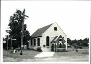
Cnr Journal & Jasper Sts Broomehill
Broomehill Museum
Mechanic's Institute
Road Board Hall, Historical Society Museum
Broomehill-Tambellup
Great Southern
Constructed from 1898
| Type | Status | Date | Documents |
|---|---|---|---|
| Heritage List | Adopted | 21 Nov 1996 |
| Type | Status | Date | Documents |
|---|---|---|---|
| RHP - To be assessed | Current | 13 Aug 2004 |
| Type | Status | Date | Grading/Management | |
|---|---|---|---|---|
| Category | ||||
| Municipal Inventory | Adopted | 21 Nov 1996 | ||
12413 Broomehill Town Centre Precinct
| Library Id | Title | Medium | Year Of Publication |
|---|---|---|---|
| 6709 | Images CD No. 22 : four buildings in Broomehill. | C D Rom | 0 |
| 6708 | Four buildings Broomehill : Broomehill Museum, Broomehill Shire Hall, Broomehill RSL & Citizens' Hall, Broomehill Shire Office : conservation plan. | Heritage Study {Cons'n Plan} | 2003 |
Individual Building or Group
| Epoch | General | Specific |
|---|---|---|
| Original Use | RELIGIOUS | Church, Cathedral or Chapel |
| Present Use | EDUCATIONAL | Museum |
| Type | General | Specific |
|---|---|---|
| Wall | BRICK | Rendered Brick |
| Roof | METAL | Corrugated Iron |
| General | Specific |
|---|---|
| SOCIAL & CIVIC ACTIVITIES | Cultural activities |
This information is provided voluntarily as a public service. The information provided is made available in good faith and is derived from sources believed to be reliable and accurate. However, the information is provided solely on the basis that readers will be responsible for making their own assessment of the matters discussed herein and are advised to verify all relevant representations, statements and information.
Constructed from 1898
Social: this building had played an important part in the life of Broomehill people. Historic: a versatile building that has been used as a hall, church and museum. One of the more important historic buildings in Broomehill.
Broomehill Museum has aesthetic value as a fine example of a Victorian Gothic building. It has high steetscape value. It is an important component of the historic centre of the town of Broomehill, and contributes to the community's sense of place.
The Broomehill Hall was used for all sorts of activities- Roads Board and other meetings, socials and Church services. This building was later known as the Mechanic's Institute. The small room added at the back was for Roads Board staff until the Roads Board offices were built at the front of Sheridan Hall. The hall was consecrated as a place of worship (Presbyterian Church) on 21st April 1929 and later became the Broomehill Museum in 1979.
Extent of Oignal Fabric: 90% Modifications: small room added at rear, vestry added when used as a church.
Good
This information is provided voluntarily as a public service. The information provided is made available in good faith and is derived from sources believed to be reliable and accurate. However, the information is provided solely on the basis that readers will be responsible for making their own assessment of the matters discussed herein and are advised to verify all relevant representations, statements and information.
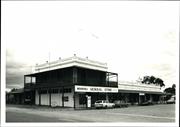
10 Journal St Broomehill
Cnr Journal & India Sts
Broomehill General Store
Broomehill-Tambellup
Great Southern
Constructed from 1911
| Type | Status | Date | Documents |
|---|---|---|---|
| National Heritage List | Nominated | 20 Jan 2006 | |
| Heritage List | Adopted | 21 Nov 1996 | |
| State Register | Registered | 27 Dec 2002 | HCWebsite.Listing+ListingDocument, HCWebsite.Listing+ListingDocument |
| Type | Status | Date | Documents |
|---|---|---|---|
| (no listings) |
| Type | Status | Date | Grading/Management | |
|---|---|---|---|---|
| Category | ||||
| Municipal Inventory | Adopted | 21 Nov 1996 | ||
12413 Broomehill Town Centre Precinct
| Library Id | Title | Medium | Year Of Publication |
|---|---|---|---|
| 7041 | A conservation plan for Jones's Buildings, Broomehill, Western Australia. | Heritage Study {Cons'n Plan} | 2004 |
| 9495 | A report on a conservation work campaign 2006-09 at Jones's Buildings (also known as Jones's Village), 49-50 India Street, Broomehill, WA 6318. | Conservation works report | 2010 |
Individual Building or Group
| Epoch | General | Specific |
|---|---|---|
| Original Use | COMMERCIAL | Shopping Complex |
| Present Use | VACANT\UNUSED | Vacant\Unused |
| Original Use | SOCIAL\RECREATIONAL | Other |
| Present Use | COMMERCIAL | Shopping Complex |
| Original Use | INDUSTRIAL\MANUFACTURING | Bakery |
| Style |
|---|
| Federation Free Classical |
| Type | General | Specific |
|---|---|---|
| Other | METAL | Pressed Metal |
| Roof | METAL | Corrugated Iron |
| Wall | BRICK | Rendered Brick |
| Other | TIMBER | Other Timber |
| General | Specific |
|---|---|
| OCCUPATIONS | Commercial & service industries |
This information is provided voluntarily as a public service. The information provided is made available in good faith and is derived from sources believed to be reliable and accurate. However, the information is provided solely on the basis that readers will be responsible for making their own assessment of the matters discussed herein and are advised to verify all relevant representations, statements and information.
Constructed from 1911
Historic: the only remaining store in Broomehill. Built for MR R jones in 1911. Social: people of Broomehill have used this facility as a place to socialise. Aesthetic: beautiful restored two storey building.
Jones’s Buildings, Broomehill, a one and two storey rendered brick building with galvanised iron roof, employing features of Federation Free Classical style. The outbuildings are in poor condition and intrusive and are of no heritage significance. the place is an intact example of a group of six shops with attached residences, including a two-storey section, in a small town in rural Western Australia.
The Broomehill Gneral Store has operated since 1911 in the same premises. Mr R Jones owned the complex which in it's day included the General Store, Bakery, Butcher, his Emporium and an office of the Union Bamk. Mr Jones imported fine goods from Europe for his tore and buyers came from far afield to make purchases.
Extent of Original Fabric: 85%
Fair
| Owner | Category |
|---|---|
| Neville & Jesse Witham | Other Private |
This information is provided voluntarily as a public service. The information provided is made available in good faith and is derived from sources believed to be reliable and accurate. However, the information is provided solely on the basis that readers will be responsible for making their own assessment of the matters discussed herein and are advised to verify all relevant representations, statements and information.
Kojonup Rd W of Broomehill
Broomehill-Tambellup
Great Southern
Constructed from 1895
| Type | Status | Date | Documents |
|---|---|---|---|
| Heritage List | Adopted | 21 Nov 1996 |
| Type | Status | Date | Documents |
|---|---|---|---|
| RHP - Does not warrant assessment | Current | 20 Dec 2019 |
| Type | Status | Date | Grading/Management | |
|---|---|---|---|---|
| Category | ||||
| Municipal Inventory | Adopted | 21 Nov 1996 | ||
Historic site
| Epoch | General | Specific |
|---|---|---|
| Present Use | MONUMENT\CEMETERY | Cemetery |
| Original Use | MONUMENT\CEMETERY | Cemetery |
| General | Specific |
|---|---|
| SOCIAL & CIVIC ACTIVITIES | Community services & utilities |
This information is provided voluntarily as a public service. The information provided is made available in good faith and is derived from sources believed to be reliable and accurate. However, the information is provided solely on the basis that readers will be responsible for making their own assessment of the matters discussed herein and are advised to verify all relevant representations, statements and information.
Constructed from 1895
Social: was used as a communal burial ground.
The Broomehill Cemetary is situated on the western edge of the township. Prior to this cemetary being opened for burials, the old cemetary at Eticup was used for interments. The old section of the cemetary was opened in 1895 for the burial of Constable John Nicholson. This section was closed after August 1926 and the new section was opened in December 1928. The burial of Arthur McGuire in 1964 was carried out in the old section.
Extent of Original Fabric: ?% Modifications: Old section closed in 1926, new section opened in 1928.
Fair
| Owner | Category |
|---|---|
| Shire of Broomehill-Tambellup | Local Gov't |
This information is provided voluntarily as a public service. The information provided is made available in good faith and is derived from sources believed to be reliable and accurate. However, the information is provided solely on the basis that readers will be responsible for making their own assessment of the matters discussed herein and are advised to verify all relevant representations, statements and information.
Latham St Broomehill
Broomehill-Tambellup
Great Southern
Constructed from 1900
| Type | Status | Date | Documents |
|---|---|---|---|
| Heritage List | Adopted | 21 Nov 1996 |
| Type | Status | Date | Documents |
|---|---|---|---|
| (no listings) |
| Type | Status | Date | Grading/Management | |
|---|---|---|---|---|
| Category | ||||
| Municipal Inventory | Adopted | 21 Nov 1996 | ||
Individual Building or Group
| Epoch | General | Specific |
|---|---|---|
| Original Use | RESIDENTIAL | Single storey residence |
| Present Use | RESIDENTIAL | Single storey residence |
| Type | General | Specific |
|---|---|---|
| Roof | METAL | Corrugated Iron |
| General | Specific |
|---|---|
| DEMOGRAPHIC SETTLEMENT & MOBILITY | Settlements |
This information is provided voluntarily as a public service. The information provided is made available in good faith and is derived from sources believed to be reliable and accurate. However, the information is provided solely on the basis that readers will be responsible for making their own assessment of the matters discussed herein and are advised to verify all relevant representations, statements and information.
Constructed from 1900
The place is one of the early dwellings in the Broomehill townsite.
This house is situated on the eastern side of the railway line in the townsite. Originally a weatherboard construction with a corrugated iron roof. The boards have been replaced with asbestos sheeting. It originally had four rooms, a passage and no bathroom. There was a chimney in the present kitchen but it has been removed. The house was lined with wide pine boards painted green. All the rooms have been rennovated and these boards are longer visible. The front door was red with red glass at the sides of the dorr frame. There was a grape vine close to the house with fuchias in the garden.
Extent of Original Fabric: 45% Modifications: The weatherboards have been replaced with asbestos sheeting, the wide green pine boards which lined the rooms have been removed.
Fair
| Owner | Category |
|---|---|
| V Steer | Other Private |
This information is provided voluntarily as a public service. The information provided is made available in good faith and is derived from sources believed to be reliable and accurate. However, the information is provided solely on the basis that readers will be responsible for making their own assessment of the matters discussed herein and are advised to verify all relevant representations, statements and information.

56 Leathley Street Broomehill
Broomehill-Tambellup
Great Southern
Constructed from 1955
| Type | Status | Date | Documents |
|---|---|---|---|
| (no listings) |
| Type | Status | Date | Documents |
|---|---|---|---|
| RHP - Does not warrant assessment | Current | 27 Feb 2015 |
| Type | Status | Date | Grading/Management | |
|---|---|---|---|---|
| Category | ||||
| (no listings) | ||||
poor
| Name | Type | Year From | Year To |
|---|---|---|---|
| State Housing Commission | Architect | - | - |
Individual Building or Group
| Epoch | General | Specific |
|---|---|---|
| Present Use | VACANT\UNUSED | Vacant\Unused |
| Original Use | RESIDENTIAL | Conjoined residence |
| Style |
|---|
| Vernacular |
| Type | General | Specific |
|---|---|---|
| Wall | ASBESTOS | Fibrous Cement, corrugated |
| Roof | TILE | Terracotta Tile |
| General | Specific |
|---|---|
| DEMOGRAPHIC SETTLEMENT & MOBILITY | Settlements |
This information is provided voluntarily as a public service. The information provided is made available in good faith and is derived from sources believed to be reliable and accurate. However, the information is provided solely on the basis that readers will be responsible for making their own assessment of the matters discussed herein and are advised to verify all relevant representations, statements and information.
Nardlah Rd Broomehill
Broomehill-Tambellup
Great Southern
Constructed from 1918
| Type | Status | Date | Documents |
|---|---|---|---|
| Heritage List | Adopted | 21 Nov 1996 |
| Type | Status | Date | Documents |
|---|---|---|---|
| (no listings) |
| Type | Status | Date | Grading/Management | |
|---|---|---|---|---|
| Category | ||||
| Municipal Inventory | Adopted | 21 Nov 1996 | ||
Individual Building or Group
| Epoch | General | Specific |
|---|---|---|
| Present Use | FARMING\PASTORAL | Homestead |
| Original Use | FARMING\PASTORAL | Homestead |
| Type | General | Specific |
|---|---|---|
| Wall | BRICK | Common Brick |
| Roof | METAL | Corrugated Iron |
| General | Specific |
|---|---|
| OCCUPATIONS | Grazing, pastoralism & dairying |
This information is provided voluntarily as a public service. The information provided is made available in good faith and is derived from sources believed to be reliable and accurate. However, the information is provided solely on the basis that readers will be responsible for making their own assessment of the matters discussed herein and are advised to verify all relevant representations, statements and information.
Constructed from 1918
Historic- Mr FS Thompson chose the Nardlah propety in 1914, building the homestead in 1918. It has been passed down through the generations to Mr Ross Thompson. Aesthetic- One of many Nor Westers homesteads located in Broomehill, Katanning and Gnowangerup districts.
Nardlah is located on the Nardlah Road, Broomehill. A neat property, of brick and corrugated iron construction. The owner leaning towards land conservation, with many trees planted over the years. The homestead ia a large rambling building.
Mr Thompson's grandfather FS Thompson was a Nor Wester who chse Broomehill district to settle in 1914.
Extent of Original Fabric: 90%
Very Good
| Owner | Category |
|---|---|
| R Thompson | Other Private |
This information is provided voluntarily as a public service. The information provided is made available in good faith and is derived from sources believed to be reliable and accurate. However, the information is provided solely on the basis that readers will be responsible for making their own assessment of the matters discussed herein and are advised to verify all relevant representations, statements and information.
Pallinup Rd Broomehill
Broomehill-Tambellup
Great Southern
Constructed from 1890
| Type | Status | Date | Documents |
|---|---|---|---|
| Heritage List | Adopted | 21 Nov 1996 |
| Type | Status | Date | Documents |
|---|---|---|---|
| (no listings) |
| Type | Status | Date | Grading/Management | |
|---|---|---|---|---|
| Category | ||||
| Municipal Inventory | Adopted | 21 Nov 1996 | ||
Historic Site
| Epoch | General | Specific |
|---|---|---|
| Present Use | COMMERCIAL | Hotel, Tavern or Inn |
| Original Use | COMMERCIAL | Hotel, Tavern or Inn |
| General | Specific |
|---|---|
| TRANSPORT & COMMUNICATIONS | Road transport |
This information is provided voluntarily as a public service. The information provided is made available in good faith and is derived from sources believed to be reliable and accurate. However, the information is provided solely on the basis that readers will be responsible for making their own assessment of the matters discussed herein and are advised to verify all relevant representations, statements and information.
Constructed from 1890
The place demonstrates associations with early travel in the district as a staing post and Inn.
At the site of the Wayside Inn, Beejenup, little is left to suggest there was an inn here. James Bridge's grave is in the corner of the block, a pile of stones and some introduced trees.
The Wayside Inn, or staging post was for travelling public's convenience. Horses were rested and fed, a bed required for the night. Mr RR Burridge ran the Inn, previously the land had belonged to James Bridges, whose grave is nearby. Bridges wife may also be buried here. The property was sold to the Murray brothers who did not continue th service, but ran a merino sheep stud.
Extent of Original Fabric: 5%
Very Poor- Remnants Only
| Owner | Category |
|---|---|
| R Wray | Other Private |
This information is provided voluntarily as a public service. The information provided is made available in good faith and is derived from sources believed to be reliable and accurate. However, the information is provided solely on the basis that readers will be responsible for making their own assessment of the matters discussed herein and are advised to verify all relevant representations, statements and information.
Pallinup Rd Broomehill
Broomehill-Tambellup
Great Southern
Constructed from 1884
| Type | Status | Date | Documents |
|---|---|---|---|
| Heritage List | Adopted | 21 Nov 1996 |
| Type | Status | Date | Documents |
|---|---|---|---|
| (no listings) |
| Type | Status | Date | Grading/Management | |
|---|---|---|---|---|
| Category | ||||
| Municipal Inventory | Adopted | 21 Nov 1996 | ||
06194 Beejenup Wayside Inn - Site of
Historic site
| Epoch | General | Specific |
|---|---|---|
| Original Use | MONUMENT\CEMETERY | Grave |
| Present Use | MONUMENT\CEMETERY | Grave |
| General | Specific |
|---|---|
| DEMOGRAPHIC SETTLEMENT & MOBILITY | Settlements |
This information is provided voluntarily as a public service. The information provided is made available in good faith and is derived from sources believed to be reliable and accurate. However, the information is provided solely on the basis that readers will be responsible for making their own assessment of the matters discussed herein and are advised to verify all relevant representations, statements and information.
Constructed from 1884
The place demonstrates an association with pioneer families of the district.
James Bridges settled the "Beejenup" property in the 1870's. This was later to become the site of the Wayside Inn ran by RR Burridge.
James Bridge headstone reads; "Sacred to the memory of JAMES BRIDGES who dept. this life Oct 14 1884 aged 70 years. He rests from his labour". The headstone replaces the original wooden headstone. James bridges wife may also be buried here.
Fair
| Owner | Category |
|---|---|
| R Wray | Other Private |
This information is provided voluntarily as a public service. The information provided is made available in good faith and is derived from sources believed to be reliable and accurate. However, the information is provided solely on the basis that readers will be responsible for making their own assessment of the matters discussed herein and are advised to verify all relevant representations, statements and information.
Pallinup Rd Broomehill
Fermoy
Broomehill-Tambellup
Great Southern
Constructed from 1875
| Type | Status | Date | Documents |
|---|---|---|---|
| Heritage List | Adopted | 21 Nov 1996 |
| Type | Status | Date | Documents |
|---|---|---|---|
| (no listings) |
| Type | Status | Date | Grading/Management | |
|---|---|---|---|---|
| Category | ||||
| Municipal Inventory | Adopted | 21 Nov 1996 | ||
Individual Building or Group
| Epoch | General | Specific |
|---|---|---|
| Present Use | FARMING\PASTORAL | Homestead |
| Original Use | FARMING\PASTORAL | Homestead |
| Type | General | Specific |
|---|---|---|
| Wall | BRICK | Handmade Brick |
| Wall | STONE | Other Stone |
| General | Specific |
|---|---|
| OCCUPATIONS | Grazing, pastoralism & dairying |
This information is provided voluntarily as a public service. The information provided is made available in good faith and is derived from sources believed to be reliable and accurate. However, the information is provided solely on the basis that readers will be responsible for making their own assessment of the matters discussed herein and are advised to verify all relevant representations, statements and information.
Constructed from 1875
Historic: Phillip McGuire left the police force in the 1870's and selected the block at Moorellup. Family records state that 'the growing family settled in and were eventually housed in a three roomed cottage made of pink hand-made bricks and affectionately known to a later generation as the "old house".
The old "Moorellup" buildings are in a dilapidated state. The new name "Fermoy" was bestowed upon the property when the new homestead was built in 1905. Moorellup is the name of a soak which was fresh until the dry season of 1940. The property has a stone constructed cottage and a brick constructed (hand made bricks) cottage.
Extent of Original Material: 45%
Very Poor
| Owner | Category |
|---|---|
| Mr McGuire | Other Private |
This information is provided voluntarily as a public service. The information provided is made available in good faith and is derived from sources believed to be reliable and accurate. However, the information is provided solely on the basis that readers will be responsible for making their own assessment of the matters discussed herein and are advised to verify all relevant representations, statements and information.
Pallinup Rd Broomehill
Broomehill-Tambellup
Great Southern
Constructed from 1905
| Type | Status | Date | Documents |
|---|---|---|---|
| Heritage List | Adopted | 21 Nov 1996 |
| Type | Status | Date | Documents |
|---|---|---|---|
| (no listings) |
| Type | Status | Date | Grading/Management | |
|---|---|---|---|---|
| Category | ||||
| Municipal Inventory | Adopted | 21 Nov 1996 | ||
Historic Site
| Epoch | General | Specific |
|---|---|---|
| Present Use | EDUCATIONAL | Combined School |
| Original Use | EDUCATIONAL | Combined School |
| General | Specific |
|---|---|
| SOCIAL & CIVIC ACTIVITIES | Education & science |
This information is provided voluntarily as a public service. The information provided is made available in good faith and is derived from sources believed to be reliable and accurate. However, the information is provided solely on the basis that readers will be responsible for making their own assessment of the matters discussed herein and are advised to verify all relevant representations, statements and information.
Constructed from 1905
Historic: one of the first bush schools in the Broomehil district. Social: the school room was used as a meeting place.
The Nigalup School is situated on the Pallinup Road, Broomehill not far from the Martinup Road turn off. The Nigalup area had a strong community and townsite was actually mapped out for this area. Mrs Searle from "Clear Hill' was the main agitator for a school here and drove her sulky to Katanning to speak with the local MP regarding a school at Nigalup.
Site Only
This information is provided voluntarily as a public service. The information provided is made available in good faith and is derived from sources believed to be reliable and accurate. However, the information is provided solely on the basis that readers will be responsible for making their own assessment of the matters discussed herein and are advised to verify all relevant representations, statements and information.
Tie Line Rd Broomehill
Broomehill-Tambellup
Great Southern
Constructed from 1987
| Type | Status | Date | Documents |
|---|---|---|---|
| Heritage List | Adopted | 21 Nov 1996 |
| Type | Status | Date | Documents |
|---|---|---|---|
| (no listings) |
| Type | Status | Date | Grading/Management | |
|---|---|---|---|---|
| Category | ||||
| Municipal Inventory | Adopted | 21 Nov 1996 | ||
Individual Building or Group
| Epoch | General | Specific |
|---|---|---|
| Original Use | SOCIAL\RECREATIONAL | Other Sports Building |
| Present Use | SOCIAL\RECREATIONAL | Other Sports Building |
| Type | General | Specific |
|---|---|---|
| Wall | BRICK | Common Brick |
| Roof | METAL | Corrugated Iron |
| General | Specific |
|---|---|
| SOCIAL & CIVIC ACTIVITIES | Sport, recreation & entertainment |
This information is provided voluntarily as a public service. The information provided is made available in good faith and is derived from sources believed to be reliable and accurate. However, the information is provided solely on the basis that readers will be responsible for making their own assessment of the matters discussed herein and are advised to verify all relevant representations, statements and information.
Constructed from 1987
Social: Ths building was built with fundraising, a grant from the Department of Sport and Recreation and Shire support. Used as the main social and function centre in Broomehill.
The Broomehill Recreational Complex is a brick construction wih an iron roof and is situated on the Tie Line Road, Broomehill. This complex combines most of the sports played in Broomehill such as tennis, golf, bowling , cricket etc.
Extent of Original Fabric: 100%
Very Good
| Owner | Category |
|---|---|
| Shire of Broomehill-Tambellup | Local Gov't |
This information is provided voluntarily as a public service. The information provided is made available in good faith and is derived from sources believed to be reliable and accurate. However, the information is provided solely on the basis that readers will be responsible for making their own assessment of the matters discussed herein and are advised to verify all relevant representations, statements and information.
Broomehill East
Northam Cranbrook over Ewlyamartup Creek
Broomehill-Tambellup
Great Southern
Constructed from 1967
| Type | Status | Date | Documents |
|---|---|---|---|
| (no listings) |
| Type | Status | Date | Documents |
|---|---|---|---|
| RHP - Does not warrant assessment | Current | 29 Oct 2021 |
| Type | Status | Date | Grading/Management | |
|---|---|---|---|---|
| Category | ||||
| (no listings) | ||||
• The place is a modest representative example of a timber road bridge constructed using sustenance labour.
• The place has some historic value for its associations with the commencement of bulk grain handling in the Great Southern.
Bridge 354, Northam Cranbrook over Ewlyamartup Creek, Broomehill East is located on the Northam Cranbrook Road (Great Southern Hwy) and crosses the Ewlyamartup Creek. The bridge is constructed of 3 spans, the overall structure measuring approximately 19m long, 9m wide, and 1.4m high. The bridge sits on driven timber piles over which lies the bridge deck with concrete overlay.
Wagyl Kaip and the Southern Noongar region refers to the Ganeang, Goreng and Minang language groups. The region includes the towns of Boyup Brook, Walpole, Denmark, Mt Barker, Cranbrook, Broomehill, Tambellup, Katanning, and Albany. The area is home to a number of significant Aboriginal sites including the Stirling Ranges. The Southern Noongar lived a hunter-gatherer lifestyle across the region until the British arrived in the 1820s-30s. Noongar people were displaced from their traditional lands and conflict continued throughout the nineteenth-century. The Great Southern Region extends from the Shires of Woodanilling and Kojonup in the northwest to Ravensthorpe in the east, and extends along the south coast from Nornalup Inlet to Oldfield River Estuary. More than half the population of the region live in greater Albany, with Katanning, Denmark and Mount Barker also having relatively large populations. Albany is a significant regional centre and serves as one of the State’s major ports. Land use across the region is mixed use farming, largely wheat and sheep, though other crops and industries are also important including barley and canola, manufacturing, vineyards, tourism, mining and timber.
Other Built Type
| Epoch | General | Specific |
|---|---|---|
| Present Use | Transport\Communications | Road: Bridge |
| Original Use | Transport\Communications | Road: Bridge |
This information is provided voluntarily as a public service. The information provided is made available in good faith and is derived from sources believed to be reliable and accurate. However, the information is provided solely on the basis that readers will be responsible for making their own assessment of the matters discussed herein and are advised to verify all relevant representations, statements and information.
Broomehill East
Pallingup River Road Bridge
MRWA Bridge 4241
Broomehill-Tambellup
Great Southern
| Type | Status | Date | Documents |
|---|---|---|---|
| (no listings) |
| Type | Status | Date | Documents |
|---|---|---|---|
| RHP - Does not warrant assessment | Current | 25 Sep 2015 |
| Type | Status | Date | Grading/Management | |
|---|---|---|---|---|
| Category | ||||
| (no listings) | ||||
Road bridge over watercourse that is 75 years old.
Fair
Other Built Type
| Epoch | General | Specific |
|---|---|---|
| Present Use | Transport\Communications | Road: Bridge |
| Original Use | Transport\Communications | Road: Bridge |
This information is provided voluntarily as a public service. The information provided is made available in good faith and is derived from sources believed to be reliable and accurate. However, the information is provided solely on the basis that readers will be responsible for making their own assessment of the matters discussed herein and are advised to verify all relevant representations, statements and information.
1841 Broomehill-Gnowangerup Rd Broomehill East
Includes meat room, blacksmith's shop, men’s quarters, a wool barn, a stone lined well, a shearing shed, and two small unmarked graves on the hill behind the homestead.
Martinup Homestead & Outbuildings
Martinup Homestead; Martinup Spring (or Soak)
Broomehill-Tambellup
Great Southern
Constructed from 1863
| Type | Status | Date | Documents |
|---|---|---|---|
| Heritage List | Adopted | 21 Nov 1996 | |
| State Register | Registered | 28 Sep 2012 | HCWebsite.Listing+ListingDocument, HCWebsite.Listing+ListingDocument |
| Type | Status | Date | Documents |
|---|---|---|---|
| (no listings) |
| Type | Status | Date | Grading/Management | |
|---|---|---|---|---|
| Category | ||||
| Municipal Inventory | Adopted | 13 Mar 1996 | ||
| Classified by the National Trust | Recorded | 11 Jun 1973 | ||
| Register of the National Estate | Indicative Place | |||
The condition of the place is very poor. The homestead house appears to have been vacant since completion of the new farmhouse in around 1973-74, and there has been very little maintenance on any of the buildings since then. The critically urgent problem is the loss of much of the corrugated iron roof sheeting, which has accelerated over the last 12 months due to two bad storms in the region. This will accelerate the loss of remaining fabric. The other major issues are rising damp and inadequate stormwater run off. Rising damp is affecting most of the significant brick buildings in the group and the homestead house is particularly affected by inadequate stormwater runoff as the slope of the land directs run-off onto its south-west wall. Most of the brick buildings have some degree of cracking and in some areas some areas of brickwork have collapsed, particularly the homestead house. There is a very bad crack in the west corner of the barn and the south-west wall is leaning out. The matchwood ceilings of the homestead house have collapsed as has a great deal of the flooring. Much of the internal joinery is swelling and warping. Despite the critical nature of the condition, the place is salvageable.
| Name | Type | Year From | Year To |
|---|---|---|---|
| Anna Maria Treasure (nee Norrish) | Architect | - | - |
Individual Building or Group
| Epoch | General | Specific |
|---|---|---|
| Original Use | FARMING\PASTORAL | Homestead |
| Original Use | FARMING\PASTORAL | Shed or Barn |
| Present Use | VACANT\UNUSED | Vacant\Unused |
| Style |
|---|
| Victorian Georgian |
| Vernacular |
| Type | General | Specific |
|---|---|---|
| Roof | TIMBER | Shingle |
| Wall | BRICK | Handmade Brick |
| Roof | METAL | Tin |
| Wall | STONE | Local Stone |
| General | Specific |
|---|---|
| PEOPLE | Early settlers |
| DEMOGRAPHIC SETTLEMENT & MOBILITY | Land allocation & subdivision |
| OCCUPATIONS | Grazing, pastoralism & dairying |
| DEMOGRAPHIC SETTLEMENT & MOBILITY | Aboriginal Occupation |
| DEMOGRAPHIC SETTLEMENT & MOBILITY | Racial contact & interaction |
| SOCIAL & CIVIC ACTIVITIES | Cultural activities |
This information is provided voluntarily as a public service. The information provided is made available in good faith and is derived from sources believed to be reliable and accurate. However, the information is provided solely on the basis that readers will be responsible for making their own assessment of the matters discussed herein and are advised to verify all relevant representations, statements and information.
Constructed from 1863
Historic- Edward Treasure se;ected the land surrounding the Martinup Soak in 1860. By 1863 his property was well developed and he leased large tracts of land in this area. The surveyor brothers camped the night 10th April 1870 at Martinup on their journey east via the Great Australian Bight. Two young sons of Edward, twins William Henry and Henry William are buried here- nfortunately a dam was excavated close to the graves adn buried them. Social- Martinup was a meeting place for early settlers in this area.
Martinup is a farm homestead complex comprising a Victorian Georgian style single storey house constructed of hand made rendered red brick with stone foundations and a corrugated iron roof overlaying the original shingle roof, a meat room, blacksmith's shop, men’s quarters a wool barn constructed of similar materials in the vernacular style, a stone lined well, constructed in 1860-63, a shearing shed of stone construction built in 1879, and two small unmarked graves on the hill behind the homestead.
Edward Treasure settled in Marinup in 1860. The bricks were made on the property, the timber carted from Albany and the large flat rocks used for flooring in the kitchen were carted from the Night Well, 65km away south of Borden.
Extent of Original Materials: 80%
Very Poor
| Owner | Category |
|---|---|
| Oldgate Nominees Pty Ltd | Other Private |
This information is provided voluntarily as a public service. The information provided is made available in good faith and is derived from sources believed to be reliable and accurate. However, the information is provided solely on the basis that readers will be responsible for making their own assessment of the matters discussed herein and are advised to verify all relevant representations, statements and information.
Broomehill West
Bridge 4233, Konjonup Road
MRWA Bridge 4233
Broomehill-Tambellup
Great Southern
| Type | Status | Date | Documents |
|---|---|---|---|
| (no listings) |
| Type | Status | Date | Documents |
|---|---|---|---|
| RHP - Does not warrant assessment | Current | 25 Sep 2015 |
| Type | Status | Date | Grading/Management | |
|---|---|---|---|---|
| Category | ||||
| (no listings) | ||||
Timber Road bridge over watercourse that is 79 years old.
Fair
Other Built Type
| Epoch | General | Specific |
|---|---|---|
| Present Use | Transport\Communications | Road: Bridge |
| Original Use | Transport\Communications | Road: Bridge |
This information is provided voluntarily as a public service. The information provided is made available in good faith and is derived from sources believed to be reliable and accurate. However, the information is provided solely on the basis that readers will be responsible for making their own assessment of the matters discussed herein and are advised to verify all relevant representations, statements and information.

Broomehill - Kojonup Rd Broomehill West
Goblup Estate
Broomehill-Tambellup
Great Southern
Constructed from 1873, Constructed from 1904
| Type | Status | Date | Documents |
|---|---|---|---|
| Heritage List | Adopted | 21 Nov 1996 |
| Type | Status | Date | Documents |
|---|---|---|---|
| RHP - Assessed - Consultation (Preliminary) | Current | 04 Jun 2014 |
| Type | Status | Date | Grading/Management | |
|---|---|---|---|---|
| Category | ||||
| Municipal Inventory | Adopted | 21 Nov 1996 | ||
• The place is a good example of a federation Queen Anne architectural style homestead.
• The place represents a way of life of an important farming family (Anderson’s)
• The place represents the wealth some pastoralist made from the land as shown by the fittings and features of the homestead.
Condeena Estate is a historic homestead significant as an outstanding example of Federation Queen Anne homstead which demonstrates the class structure of the time. The place is also significant for its association with sheep breeder Thomas Anderson and for the archaeological remnants of the earlier Goblup Estate developed by Lady Cockburn-Campbell and Lord Brassey.
Workman Cottage Simple rectangular design CGI roofing Verandah at front supported by wooden poles. Condeena Estate Large house, with a rectangular design. Large courtyard Surrounding verandah Double gable roof 3 corbelled chimneys
Workman Cottage ‘This building, believed to be a workmen’s cottage is all the remains of the buildings of the ‘Goblup Estate’, now ‘Condeena’. ‘Goblup’ was owned by the Dowager, Sophia, Lady Cockburn-Campbell followed by Lord Brassey.’ Condeena Estate ‘The homestead at Condeena is a large gracious building with verandahs and a courtyard. Built in 1904 for Tom Anderson who had come here from the North West with his brother Ross. The ‘Goblup’ Estate was divided between the brothers and Ross took the half closest to Katanning and named it ‘Illareen’ and Tom Named his half ‘Condeena’. The Shire of Katanning Municipal Inventory states: ‘The property known as ‘Illareen’ was formed when the large property ‘Goblup’ was divided by the owner Ross Anderson into two properties ‘Illareen’ and ‘Condeena’. This was in 1904. Ross Anderson died at Katanning in 1945. Before his death ‘Illareen’ was formed into a company known as R. Anderson Co.’
High
Good
Individual Building or Group
| Epoch | General | Specific |
|---|---|---|
| Present Use | FARMING\PASTORAL | Homestead |
| Original Use | FARMING\PASTORAL | Homestead |
| Style |
|---|
| Federation Queen Anne |
| Victorian Georgian |
| Type | General | Specific |
|---|---|---|
| Wall | BRICK | Common Brick |
| Roof | METAL | Corrugated Iron |
| Wall | STONE | Granite |
| General | Specific |
|---|---|
| OCCUPATIONS | Grazing, pastoralism & dairying |
This information is provided voluntarily as a public service. The information provided is made available in good faith and is derived from sources believed to be reliable and accurate. However, the information is provided solely on the basis that readers will be responsible for making their own assessment of the matters discussed herein and are advised to verify all relevant representations, statements and information.
Constructed from 1870, Constructed from 1904
Historic- Tom Anderson was one of many Nor Westers to settle in the Broomehill District. Social- In the early days of the Eticup settlement, Church services were held at "Goblup Estate". Aesthetic: A beautiful homestead that has been maintained in a gracoous manner.
The homestead at "Condeena Estate" is a large gracious building has a rectangular design, large courtyard, surrounding verandah, double gable roof and 3 corbelled chimneys. Workman Cottage - Simple rectangular design, with CGI roofing. Verandah at front supported by wooden poles.
Built in 1904 for Tom Anderson who had come here from the North West with his brother Ross. The "Goblup Estate" was divided up among the brothers and Ross tokk the half closest to Katanning and names it "Illareen" and Tom named hi half "Condeena".
Extent of Original Fabric: 80%
Good
| Owner | Category |
|---|---|
| Goblup Downs Pty Ltd | Other Private |
This information is provided voluntarily as a public service. The information provided is made available in good faith and is derived from sources believed to be reliable and accurate. However, the information is provided solely on the basis that readers will be responsible for making their own assessment of the matters discussed herein and are advised to verify all relevant representations, statements and information.