Local Government
Broomehill-Tambellup
Region
Great Southern
Broomehill-Kojonup Rd, front of Eticup Broomehill
Broomehill-Tambellup
Great Southern
Constructed from 1985
| Type | Status | Date | Documents |
|---|---|---|---|
| Heritage List | Adopted | 21 Nov 1996 |
| Type | Status | Date | Documents |
|---|---|---|---|
| (no listings) |
| Type | Status | Date | Grading/Management | |
|---|---|---|---|---|
| Category | ||||
| Municipal Inventory | Adopted | 21 Nov 1996 | ||
Historic site
| Epoch | General | Specific |
|---|---|---|
| Original Use | MONUMENT\CEMETERY | Monument |
| Present Use | MONUMENT\CEMETERY | Monument |
| General | Specific |
|---|---|
| DEMOGRAPHIC SETTLEMENT & MOBILITY | Settlements |
This information is provided voluntarily as a public service. The information provided is made available in good faith and is derived from sources believed to be reliable and accurate. However, the information is provided solely on the basis that readers will be responsible for making their own assessment of the matters discussed herein and are advised to verify all relevant representations, statements and information.
Constructed from 1985
The Eticup Memorial commemorates the little settlements' rise and decline in the 1880's. Located outside Mrs D Dennis' fence on the Broomehill/Kojonup Road, the plaque shows the location of the settlement's stores, Inn, blacksmithy's and houses.
Eticup was a thriving settlement with two stores , an Inn, two blacksmiths, a Church/schoolroom and resident's houses. The settlement declined when the Great Southern Railway passed 6km to the east and most of the town's businessmen tranferrred thier various trades to Broome Hill, the siding which became a town. The settlers at Eticup included the garritys, Krakouers, Carmodys, Tylors, Rogers, Nelsons, rown, Whittons and various landholders on surrounding properties. The settlement also has a cemetary which is believed to have around 30 people buried there.
Good
| Owner | Category |
|---|---|
| Mrs D Dennis | Other Private |
This information is provided voluntarily as a public service. The information provided is made available in good faith and is derived from sources believed to be reliable and accurate. However, the information is provided solely on the basis that readers will be responsible for making their own assessment of the matters discussed herein and are advised to verify all relevant representations, statements and information.
Broomehill-Kojonup Rd, front of Eticup Broomehill
Broomehill-Tambellup
Great Southern
Constructed from 1985
| Type | Status | Date | Documents |
|---|---|---|---|
| Heritage List | Adopted | 21 Nov 1996 |
| Type | Status | Date | Documents |
|---|---|---|---|
| (no listings) |
| Type | Status | Date | Grading/Management | |
|---|---|---|---|---|
| Category | ||||
| Municipal Inventory | Adopted | 21 Nov 1996 | ||
Historic site
| Epoch | General | Specific |
|---|---|---|
| Original Use | MONUMENT\CEMETERY | Monument |
| Present Use | MONUMENT\CEMETERY | Monument |
| General | Specific |
|---|---|
| DEMOGRAPHIC SETTLEMENT & MOBILITY | Exploration & surveying |
This information is provided voluntarily as a public service. The information provided is made available in good faith and is derived from sources believed to be reliable and accurate. However, the information is provided solely on the basis that readers will be responsible for making their own assessment of the matters discussed herein and are advised to verify all relevant representations, statements and information.
Constructed from 1985
This plaque commemorates the passing of JS Roe's party on their expidition south in 1835.
The JS Roe Plaque is located alongside the Eticup Plaque at the front of Mrs D Dennis 'Eticup' property. Plaque set on granite.
Good
| Owner | Category |
|---|---|
| Mrs D Dennis | Other Private |
This information is provided voluntarily as a public service. The information provided is made available in good faith and is derived from sources believed to be reliable and accurate. However, the information is provided solely on the basis that readers will be responsible for making their own assessment of the matters discussed herein and are advised to verify all relevant representations, statements and information.
Condeena property Broomehill
on Carmondy's original property
Broomehill-Tambellup
Great Southern
Constructed from 1888
| Type | Status | Date | Documents |
|---|---|---|---|
| Heritage List | Adopted | 21 Nov 1996 |
| Type | Status | Date | Documents |
|---|---|---|---|
| RHP - To be assessed | Current | 10 Sep 2004 |
| Type | Status | Date | Grading/Management | |
|---|---|---|---|---|
| Category | ||||
| Municipal Inventory | Adopted | |||
06198 Condeena Estate, Broomehill
Historic site
| Epoch | General | Specific |
|---|---|---|
| Original Use | MONUMENT\CEMETERY | Grave |
| Present Use | MONUMENT\CEMETERY | Grave |
| General | Specific |
|---|---|
| DEMOGRAPHIC SETTLEMENT & MOBILITY | Settlements |
This information is provided voluntarily as a public service. The information provided is made available in good faith and is derived from sources believed to be reliable and accurate. However, the information is provided solely on the basis that readers will be responsible for making their own assessment of the matters discussed herein and are advised to verify all relevant representations, statements and information.
Constructed from 1888
The place demonstartes associations with early pioneering families.
The grave of Thomas Francis Carmody is situated on "Condeena Estate", not on the original "Goblup Estate" land but on Patrick Carmody's land later purchased and included in "Condeena" The grave is marked with the rermains of a post and rail fence, with a stone ready for a plaque.
Thomas Francis Carmody, son of Patrick and /eliza (nee Annice) Carmody was born on 12th March 1879 at Eticup and died here on 31st January 1888.
Poor
| Owner | Category |
|---|---|
| I Anderson | Other Private |
This information is provided voluntarily as a public service. The information provided is made available in good faith and is derived from sources believed to be reliable and accurate. However, the information is provided solely on the basis that readers will be responsible for making their own assessment of the matters discussed herein and are advised to verify all relevant representations, statements and information.
11a Davine St Broomehill
Other address listed as Lot 72 Janitor St, Broomehill
Broomehill-Tambellup
Great Southern
| Type | Status | Date | Documents |
|---|---|---|---|
| (no listings) |
| Type | Status | Date | Documents |
|---|---|---|---|
| (no listings) |
| Type | Status | Date | Grading/Management | |
|---|---|---|---|---|
| Category | ||||
| (no listings) | ||||
Individual Building or Group
| Epoch | General | Specific |
|---|---|---|
| Original Use | RESIDENTIAL | Single storey residence |
| Present Use | RESIDENTIAL | Single storey residence |
| Type | General | Specific |
|---|---|---|
| Roof | TILE | Other Tile |
| Other | TIMBER | Other Timber |
| Wall | ASBESTOS | Fibrous Cement, weatherboard |
This information is provided voluntarily as a public service. The information provided is made available in good faith and is derived from sources believed to be reliable and accurate. However, the information is provided solely on the basis that readers will be responsible for making their own assessment of the matters discussed herein and are advised to verify all relevant representations, statements and information.
This information is provided voluntarily as a public service. The information provided is made available in good faith and is derived from sources believed to be reliable and accurate. However, the information is provided solely on the basis that readers will be responsible for making their own assessment of the matters discussed herein and are advised to verify all relevant representations, statements and information.
Eticup Settlement Broomehill
Broomehill-Tambellup
Great Southern
Constructed from 1888 to 1889
| Type | Status | Date | Documents |
|---|---|---|---|
| Heritage List | Adopted | 21 Nov 1996 |
| Type | Status | Date | Documents |
|---|---|---|---|
| (no listings) |
| Type | Status | Date | Grading/Management | |
|---|---|---|---|---|
| Category | ||||
| Municipal Inventory | Adopted | 21 Nov 1996 | ||
Historic Site
| Epoch | General | Specific |
|---|---|---|
| Present Use | RESIDENTIAL | Other |
| Original Use | RESIDENTIAL | Other |
| General | Specific |
|---|---|
| DEMOGRAPHIC SETTLEMENT & MOBILITY | Settlements |
This information is provided voluntarily as a public service. The information provided is made available in good faith and is derived from sources believed to be reliable and accurate. However, the information is provided solely on the basis that readers will be responsible for making their own assessment of the matters discussed herein and are advised to verify all relevant representations, statements and information.
Constructed from 1889, Constructed from 1888
The place demonstrates associations with pioneering families. It is one of only two sites left in Eticup.
The ruins of the Whitton's house can still be seen from the Broomehill/Kojonup Road.
Whitton was a memeber of the Eticup community in the 1880's, not much being known about him.
Extent of Original Fabric" 30%
Very Poor- Remnants Only
| Owner | Category |
|---|---|
| RD Meyer | Other Private |
This information is provided voluntarily as a public service. The information provided is made available in good faith and is derived from sources believed to be reliable and accurate. However, the information is provided solely on the basis that readers will be responsible for making their own assessment of the matters discussed herein and are advised to verify all relevant representations, statements and information.
Flat Rocks Rd Broomehill
SLKm 9.17 Map 1 WH4
MRWA 4238
Broomehill-Tambellup
Great Southern
Constructed from 1907
| Type | Status | Date | Documents |
|---|---|---|---|
| Heritage List | Adopted | 21 Nov 1996 |
| Type | Status | Date | Documents |
|---|---|---|---|
| RHP - Does not warrant assessment | Current | 28 Nov 2003 |
| Type | Status | Date | Grading/Management | |
|---|---|---|---|---|
| Category | ||||
| Municipal Inventory | Adopted | 21 Nov 1996 | ||
| Statewide Lge Timber Str Survey | Completed | 11 Dec 1998 | ||
Other Built Type
| Epoch | General | Specific |
|---|---|---|
| Original Use | Transport\Communications | Road: Bridge |
| Present Use | Transport\Communications | Road: Bridge |
| Type | General | Specific |
|---|---|---|
| Other | TIMBER | Other Timber |
| General | Specific |
|---|---|
| TRANSPORT & COMMUNICATIONS | Road transport |
This information is provided voluntarily as a public service. The information provided is made available in good faith and is derived from sources believed to be reliable and accurate. However, the information is provided solely on the basis that readers will be responsible for making their own assessment of the matters discussed herein and are advised to verify all relevant representations, statements and information.
Constructed from 1907
The bridge joined the community of Flat Rocks to Broomehill, prior to tis, if the river was up then crossing was difficult.
The old bridge over the Wajeganup River is adjacent to the new bridge. Used as a stock crossing now.
Mrs R hancock can recall when the river was teeming with fish, gilgies and birdlife, now the river is turning saline.
Extent of Original Fabric: 85%
Poor
| Owner | Category |
|---|---|
| Shire of Broomehill-Tambellup | Local Gov't |
This information is provided voluntarily as a public service. The information provided is made available in good faith and is derived from sources believed to be reliable and accurate. However, the information is provided solely on the basis that readers will be responsible for making their own assessment of the matters discussed herein and are advised to verify all relevant representations, statements and information.
Flat Rocks Rd Broomehill
Broomehill-Tambellup
Great Southern
Constructed from 1906
| Type | Status | Date | Documents |
|---|---|---|---|
| Heritage List | Adopted | 21 Nov 1996 |
| Type | Status | Date | Documents |
|---|---|---|---|
| (no listings) |
| Type | Status | Date | Grading/Management | |
|---|---|---|---|---|
| Category | ||||
| Municipal Inventory | Adopted | 21 Nov 1996 | ||
Historic Site
| Epoch | General | Specific |
|---|---|---|
| Present Use | EDUCATIONAL | Combined School |
| Original Use | EDUCATIONAL | Combined School |
| General | Specific |
|---|---|
| SOCIAL & CIVIC ACTIVITIES | Community services & utilities |
This information is provided voluntarily as a public service. The information provided is made available in good faith and is derived from sources believed to be reliable and accurate. However, the information is provided solely on the basis that readers will be responsible for making their own assessment of the matters discussed herein and are advised to verify all relevant representations, statements and information.
Constructed from 196
Historic: the Flat Rocks School serviced the education needs of settlers' children in that area. Classes ceased when the children were bused to Broomeholl in 1945.
The Flat Rocks School site is little more than a few trees besides the Flat Rocks Road, Broomehill. Opposite is the Flat Rocks Tennis Club and Hall. Tennis is still being played on these courts.
Extent of Original Fabric: 0%
Site Only
This information is provided voluntarily as a public service. The information provided is made available in good faith and is derived from sources believed to be reliable and accurate. However, the information is provided solely on the basis that readers will be responsible for making their own assessment of the matters discussed herein and are advised to verify all relevant representations, statements and information.
Flat Rocks Rd Broomehill
Flat Rocks Hall
Broomehill-Tambellup
Great Southern
Constructed from 1906
| Type | Status | Date | Documents |
|---|---|---|---|
| Heritage List | Adopted | 21 Nov 1996 |
| Type | Status | Date | Documents |
|---|---|---|---|
| (no listings) |
| Type | Status | Date | Grading/Management | |
|---|---|---|---|---|
| Category | ||||
| Municipal Inventory | Adopted | 21 Nov 1996 | ||
Individual Building or Group
| Epoch | General | Specific |
|---|---|---|
| Present Use | SOCIAL\RECREATIONAL | Other Sports Building |
| Original Use | SOCIAL\RECREATIONAL | Other Community Hall\Centre |
| Type | General | Specific |
|---|---|---|
| Wall | TIMBER | Weatherboard |
| Roof | METAL | Corrugated Iron |
| General | Specific |
|---|---|
| SOCIAL & CIVIC ACTIVITIES | Sport, recreation & entertainment |
This information is provided voluntarily as a public service. The information provided is made available in good faith and is derived from sources believed to be reliable and accurate. However, the information is provided solely on the basis that readers will be responsible for making their own assessment of the matters discussed herein and are advised to verify all relevant representations, statements and information.
Constructed from 1906
Social: used for social functions by the settlers of Flat Rocks. Later years used as a tennis club premises and clubrooms. Historic: The Flat Rocks community was in an isolated area and was a strong community. A hall and school across the road were built for the community's use.
A weatherboard and iron roof construction, the Flat Rocks Tennis Club building was formerly the Flat Rock Hall built for and by the settlers in that area. One side of the hall (facing the courts) was opened and is now used as a shelter for tennis players.
Extent of Original Fabric: 60% Modifications: one side opened.
Fair
This information is provided voluntarily as a public service. The information provided is made available in good faith and is derived from sources believed to be reliable and accurate. However, the information is provided solely on the basis that readers will be responsible for making their own assessment of the matters discussed herein and are advised to verify all relevant representations, statements and information.
Flat Rocks Rd Broomehill
Broomehill-Tambellup
Great Southern
Constructed from 1888
| Type | Status | Date | Documents |
|---|---|---|---|
| Heritage List | Adopted | 21 Nov 1996 |
| Type | Status | Date | Documents |
|---|---|---|---|
| (no listings) |
| Type | Status | Date | Grading/Management | |
|---|---|---|---|---|
| Category | ||||
| Municipal Inventory | Adopted | 21 Nov 1996 | ||
Historic site
| Epoch | General | Specific |
|---|---|---|
| Present Use | MONUMENT\CEMETERY | Grave |
| Original Use | MONUMENT\CEMETERY | Grave |
| General | Specific |
|---|---|
| DEMOGRAPHIC SETTLEMENT & MOBILITY | Settlements |
This information is provided voluntarily as a public service. The information provided is made available in good faith and is derived from sources believed to be reliable and accurate. However, the information is provided solely on the basis that readers will be responsible for making their own assessment of the matters discussed herein and are advised to verify all relevant representations, statements and information.
Constructed from 1888
The place demonstrates associations with pioneering families in the district.
This grave situated on the "Hayfield" property which was settled in the 1860's and first named "Coorinyup" after it's location.
George Howard Annice was born at "Hayfield" on 29th November 1885. He was buried here 23rd July 1888.
| Owner | Category |
|---|---|
| NJ Witham | Other Private |
This information is provided voluntarily as a public service. The information provided is made available in good faith and is derived from sources believed to be reliable and accurate. However, the information is provided solely on the basis that readers will be responsible for making their own assessment of the matters discussed herein and are advised to verify all relevant representations, statements and information.
30374 Great Southern Highway Broomehill
Broomehill-Tambellup
Great Southern
| Type | Status | Date | Documents |
|---|---|---|---|
| (no listings) |
| Type | Status | Date | Documents |
|---|---|---|---|
| RHP - Does not warrant assessment | Current | 30 Jun 2017 |
| Type | Status | Date | Grading/Management | |
|---|---|---|---|---|
| Category | ||||
| (no listings) | ||||
• The place is a representative example of a large timber and iron storage shed located in a rural area.
• The place is associated with the development and growth of the Broomehill district in the early 1930s.
The place comprises a shed constructed of corrugated iron with a timber frame, 16m x 19.70m, with roof beams of 4 x 2 metres, supported by 3 solid timber tree trunks. It is open to the front which is enclosed with mesh fencing. The shed houses a large collection of farm machinery donated by local farmers to the Broomehill Historical Society. It is the only building occupying a large lot and is not adjacent to any other buildings.
The first Europeans settlers in the Broomehill district were sandalwood cutters and pastoralists. A track developed between Perth and Albany, largely as a result of the sandalwood cutters carting their loads to the coast for export to China. In 1841, a mail service was established along this route, and in 1869, the Government took over the mail run. The mail coach made the journey each way twice a month, travelling around 30 miles a day, and carried both passengers and freight. By 1881, the Colonial Government decided that a railway line would be the most efficient and cost-effective transport solution between Perth and Albany. The Government arranged for the line to be constructed by the West Australian Land Company under the land grant system, and the Great Southern line was officially opened on 1 June 1889. The town of Broomehill was established by the WA Land Company as part of its Great Southern Railway project. It was named after Governor Sir Frederick Napier Broome. The townsite was gazetted in 1890, a year after the railway was officially opened, and it became a stopping point for gold prospectors on their way from Albany to the Coolgardie goldfields. However, the Company experienced difficulties in attracting settlers to take up their land, and in 1897, the Government purchased the line and all the Company lands, for £1,100,000. Between 1900 and 1914, there was great demand for land along the Great Southern Railway route as miners leaving the failing goldfields joined other settlers to take up farming land and the population grew rapidly during this period.
Individual Building or Group
This information is provided voluntarily as a public service. The information provided is made available in good faith and is derived from sources believed to be reliable and accurate. However, the information is provided solely on the basis that readers will be responsible for making their own assessment of the matters discussed herein and are advised to verify all relevant representations, statements and information.
30360 Great Southern Hwy Broomehill
Previoulsy noted as being on Jasper Street, Broomehill.
Town Hall, Sheridans Hall
Broomehill-Tambellup
Great Southern
Constructed from 1910 to 1928
| Type | Status | Date | Documents |
|---|---|---|---|
| Heritage List | Adopted | 21 Nov 1996 | |
| State Register | Registered | 04 Nov 2005 | HCWebsite.Listing+ListingDocument, HCWebsite.Listing+ListingDocument |
| Type | Status | Date | Documents |
|---|---|---|---|
| (no listings) |
| Type | Status | Date | Grading/Management | |
|---|---|---|---|---|
| Category | ||||
| Classified by the National Trust | Classified | 01 Jun 2000 | ||
| Municipal Inventory | Adopted | 21 Nov 1996 | ||
| Municipal Inventory | Adopted | 21 Nov 1996 | ||
12413 Broomehill Town Centre Precinct
Broomehill Shire Hall & Road Board Offices (fmr) is in fair condition, although very little maintenance has been carried out on the building for a number of years. Recently a large proportion of the stumps were replaced.
| Library Id | Title | Medium | Year Of Publication |
|---|---|---|---|
| 6709 | Images CD No. 22 : four buildings in Broomehill. | C D Rom | 0 |
| 6708 | Four buildings Broomehill : Broomehill Museum, Broomehill Shire Hall, Broomehill RSL & Citizens' Hall, Broomehill Shire Office : conservation plan. | Heritage Study {Cons'n Plan} | 2003 |
Individual Building or Group
| Epoch | General | Specific |
|---|---|---|
| Original Use | GOVERNMENTAL | Town, Shire or District Hall |
| Present Use | GOVERNMENTAL | Town, Shire or District Hall |
| Original Use | GOVERNMENTAL | Office or Administration Bldg |
| Original Use | SOCIAL\RECREATIONAL | Other |
| Style |
|---|
| Federation Anglo-Dutch |
| Vernacular |
| Type | General | Specific |
|---|---|---|
| Roof | METAL | Corrugated Iron |
| Wall | TIMBER | Other Timber |
| Wall | BRICK | Common Brick |
| Wall | METAL | Other Metal |
| General | Specific |
|---|---|
| TRANSPORT & COMMUNICATIONS | Road transport |
| SOCIAL & CIVIC ACTIVITIES | Sport, recreation & entertainment |
| SOCIAL & CIVIC ACTIVITIES | Community services & utilities |
| SOCIAL & CIVIC ACTIVITIES | Government & politics |
This information is provided voluntarily as a public service. The information provided is made available in good faith and is derived from sources believed to be reliable and accurate. However, the information is provided solely on the basis that readers will be responsible for making their own assessment of the matters discussed herein and are advised to verify all relevant representations, statements and information.
The place is a good example of rural civic architecture in what may be classified as Federation with an interwar addition in Cape Dutch gable style. The predominant feature of three parapeted gables is unusual and possible unique, and this large and distinctive building has aesthetic significance and considerable prominence forming a significant landmark on the main Great Southern Highway. The place is a demonstration of the continued development that occurred in Broomehill as it became a service centre of the district. It has historical and social significance as a place of community gathering and a centre of both official and informal social functions over a period of many years. The well preserved building is in good condition and is an unusual and rare example of this genre. AESTHETIC VALUE The frontage of the Broomehill Shire Hall building is a good but unusual example of architectural style still practised, in the interwar period based on the earlier federation style. It may be described as Federation Freestyle. The style is primarily non-residential and includes among characteristic indicators, parapets with a curvilinear apex. The building, although unusual, is representative of the way that Federation styling was applied in country areas of was and is one of the only few such examples extant. The building’s façade has been well maintained and the original fabric is mostly intact. The place is a significant landmark identifying the township and makes and important contribution to the streetscape with its façade treatment of rendered and painted brickwork and its distinctive gables. The preservation of the place is a demonstration of the appreciation of the aesthetic exhibited by the building and show that it is highly valued by the community. SOCIAL VALUE The place represents a way of life no longer practised, when relatively difficult transportation and communication largely depended on the horse and limited opportunities for business and social gatherings. It demonstrates ways of life in an isolated agricultural community and has strong associations with the development of the Broomehill area. The Hall has provided an important meeting place for the local community over many years and has been a major centre for discussion and decision making regarding the development of the area, as well as a centre for social functions, both formal and informal and a venue for skating, dances and cinema entertainment. RARITY AND REPRESENTATIVENESS The building is representative of architectural style as applied in country areas of W.A. but is probably unique in its manifestation of that style, is one of only a few such examples and is one of the better preserved. CONDITION, INTEGRITY AND AUTHENTICITY This is an authentic building with the original built fabric relatively intact and in excellent condition. The place is a well preserved and maintained example of the genre and is valued as one of Broomehill’s heritage buildings. The building has been only slightly altered internally and its integrity is still very high despite these alterations and some extensions. It has been well maintained so that the building can continue to be effectively utilised and cared for.
This distinctive and imposing building fronting the Great Southern Highway and the rail line creates a major landmark and, together with the adjacent hotel, is the main identification of the town to passing travellers. The place has a main hall with brick front rooms and the Interwar Architectural style of the frontage is quite striking and unusual. Two main rendered brick gables with curvilinear apexes, reminiscent of Cape Dutch architecture, are linked by a smaller gable of similar shape between them over the central recessed entrance through double timber doors. A gables parapet with no-pointed apex is an important indicator of the style identified by Apperley, Irving and Reynolds as Federation Freestyle and since these three gabled parapets form the predominant feature of the frontage of this building it may be classified in this way. The brick gables which also feature a centrally placed small semi-circular windows, are currently highlighted by being painted white with the cappings picked out in strongly contrasting blue colour. The small central gable carries the date 1928 in raised numerals also picked out in blue. This colour treatment is followed throughout the rest of the exterior and the contrasting colour is used to emphasise the gutters and visually ties the later additions at the right hand end of the façade to the older building. The cement plinth across the front and a horizontal raised moulding below the sills of the timber casement window is also painted blue. The corrugated iron roofs of these 1928 buildings are pierced by three tall rectangular brick chimneys and the top of the original parapet wall also shows through the left gable roof. Behind this front section is the original hall itself which has a simple gable spanning the full width of the building covered by a relatively new metal roof which rises above the front section. The walls of the hall are timber framed clad with corrugated iron externally and plasterboard on the inside. The interior detailing is very plain and basic but in almost original condition with a stage at the far end. Memorial plaques are hung on the walls of the entrance hall.
Assessment:2000 Broomehill (Originally Broome Hill, named after Sir Frederick Napier Broome, Governor of Western Australia) is located on the Great Southern Highway between Katanning and Tambellup in the Great Southern Region, 300 kms south east of Perth. The Great Southern Railway reached Broomehill in 1889, settlement rapidly grew and it became a centre for supplies to the surrounding district. In 1959 the spelling of the town’s name was changed from Broome Hill to one word – Broomehill, and this was gazetted on 16 February. Originally the hall was built I n 1910 by Mr George Green for Mrs Kathleen Sheridan. This became the present shire hall. The Hall was built of galvanised Iron and utilised as a skating rink, dances and a cinema. In 1917 it was acquired by the Road Board and brick additions made to the front in 1928. In the 1960’s the Broomehill Shire Council required more office space than that available in the hall and it was decided that a new shire complex be built on land adjacent to the hall. The new complex opened in 1964.
The original corrugated iron hall built in 1910 had the distinctive brick front section added in 1928 providing offices and a board room for the Roads Board. The fabric of these constructions is relatively intact and in virtually original condition. A toilet block and front awning were added c.1960.
This information is provided voluntarily as a public service. The information provided is made available in good faith and is derived from sources believed to be reliable and accurate. However, the information is provided solely on the basis that readers will be responsible for making their own assessment of the matters discussed herein and are advised to verify all relevant representations, statements and information.
Constructed from 1928, Constructed from 1910
This place is part of the Broomehill streetscape since 1910.
A timber framed, iron clad hall in Federation vernacular style with a Inter-War Anglo-Dutch brick frontage. ARCHITECTURAL STYLE - Inter War Anglo Dutch The hall is a single storey brick building with a CGI roof. The front of the building is very distinctive with a symmetrical rendered facade featuring Dutch Gables on either side of a double door main entry, and a samller gable over the entry section. The 1910 hall is evidence by a high gable roof with vents seen in the gable from street level.
The hall was used as a skating rink, meeting place and for dances, socials and other functions. Was used regularly for most functions in Broomehill until Recreational Centre was built in 1986.
Extent of Original Fabric: 70% Modifications: brick front added in 1928.
Fair
| Owner | Category |
|---|---|
| Shire of Broomehill-Tambellup | Local Gov't |
This information is provided voluntarily as a public service. The information provided is made available in good faith and is derived from sources believed to be reliable and accurate. However, the information is provided solely on the basis that readers will be responsible for making their own assessment of the matters discussed herein and are advised to verify all relevant representations, statements and information.
30360 Great Southern Hwy Broomehill
Previously noted as being on Jasper Street. Located next to Town Hall
Broomehill-Tambellup
Great Southern
Constructed from 1964
| Type | Status | Date | Documents |
|---|---|---|---|
| Heritage List | Adopted | 21 Nov 1996 |
| Type | Status | Date | Documents |
|---|---|---|---|
| RHP - To be assessed | Current | 13 Aug 2004 |
| Type | Status | Date | Grading/Management | |
|---|---|---|---|---|
| Category | ||||
| Municipal Inventory | Adopted | 21 Nov 1996 | ||
12413 Broomehill Town Centre Precinct
A rendered brick with iron roof building, designed by Margaret Feilman & Associates, the proportions of the building are low and horizontal. Single storey at front, and two storey at rear, with small balcony protruding and carpark below. Located near the centre of town, next to the Town Hall. The building is built in the style of the 1960's and is good example of the achitecture of that period.
| Name | Type | Year From | Year To |
|---|---|---|---|
| Margaret Feilman & Associates | Architect | - | - |
| Library Id | Title | Medium | Year Of Publication |
|---|---|---|---|
| 6708 | Four buildings Broomehill : Broomehill Museum, Broomehill Shire Hall, Broomehill RSL & Citizens' Hall, Broomehill Shire Office : conservation plan. | Heritage Study {Cons'n Plan} | 2003 |
| 6709 | Images CD No. 22 : four buildings in Broomehill. | C D Rom | 0 |
Individual Building or Group
| Epoch | General | Specific |
|---|---|---|
| Original Use | GOVERNMENTAL | Office or Administration Bldg |
| Present Use | GOVERNMENTAL | Office or Administration Bldg |
| Style |
|---|
| Post-War International |
| Type | General | Specific |
|---|---|---|
| Roof | METAL | Corrugated Iron |
| Wall | BRICK | Rendered Brick |
This information is provided voluntarily as a public service. The information provided is made available in good faith and is derived from sources believed to be reliable and accurate. However, the information is provided solely on the basis that readers will be responsible for making their own assessment of the matters discussed herein and are advised to verify all relevant representations, statements and information.
Constructed from 1964
This building gives a good representation of the architecture of the 1960's.
A rendered brick with iron roof construction, designed by Margaret Feilman & Associates, the proportions of the building are low and horizontal. Single storey at front, and two storey at rear, with small balcony protruding and carpark below. Located near the centre of town, next to the Town Hall. The building is built in the style of the 1960's and is good example of the achitecture of that period.
Extent of original Fabric: 90%
Good
| Name | Type | Year From | Year To |
|---|---|---|---|
| Margaret Feilman & Associates | Architect | 1964 | - |
| Owner | Category |
|---|---|
| Shire of Broomehill-Tambellup | Local Gov't |
This information is provided voluntarily as a public service. The information provided is made available in good faith and is derived from sources believed to be reliable and accurate. However, the information is provided solely on the basis that readers will be responsible for making their own assessment of the matters discussed herein and are advised to verify all relevant representations, statements and information.
Greenhills Rd Broomehill
Broomehill-Tambellup
Great Southern
Constructed from 1885
| Type | Status | Date | Documents |
|---|---|---|---|
| Heritage List | Adopted | 21 Nov 1996 |
| Type | Status | Date | Documents |
|---|---|---|---|
| (no listings) |
| Type | Status | Date | Grading/Management | |
|---|---|---|---|---|
| Category | ||||
| Municipal Inventory | Adopted | 21 Nov 1996 | ||
Historic site
| Epoch | General | Specific |
|---|---|---|
| Present Use | MONUMENT\CEMETERY | Cemetery |
| Original Use | MONUMENT\CEMETERY | Cemetery |
| General | Specific |
|---|---|
| SOCIAL & CIVIC ACTIVITIES | Community services & utilities |
This information is provided voluntarily as a public service. The information provided is made available in good faith and is derived from sources believed to be reliable and accurate. However, the information is provided solely on the basis that readers will be responsible for making their own assessment of the matters discussed herein and are advised to verify all relevant representations, statements and information.
Constructed from 1885
Historic: there are believed to be 29 graves in the Eticup Cemetary but only 4 bear headstones. Those that have been traced include; Mrs Louis van Zuilecom and her son Henry, Thomas Norrish and his son George, Algernon Trimmer, Joseph Nelson Snr and his grandson (the infant son of Nathaniel and Mary Nelson), the infant son of Ben and Annie Bransby, James and Sonny, the 3 and 5 years' old sons of Thomas and Alice Birchall, Edward Brown, William and Mrs Peate, the little daughter of a railway worker, George Birchall and Nathanial Birchall's son, nathanial.
The Eticup Cemetary is a small cemetary, one of a few reminders of the small village of Eticup, 6km west of Broomehill. Located on the eastern side of the Greenhills Road and north of the St Peter's Church site, which is on the opposite side of the road.
Fair
| Owner | Category |
|---|---|
| R Meyer | Other Private |
This information is provided voluntarily as a public service. The information provided is made available in good faith and is derived from sources believed to be reliable and accurate. However, the information is provided solely on the basis that readers will be responsible for making their own assessment of the matters discussed herein and are advised to verify all relevant representations, statements and information.
Greenhills Rd Broomehill
Part of Condeena Estate
Broomehill-Tambellup
Great Southern
Constructed from 1886
| Type | Status | Date | Documents |
|---|---|---|---|
| Heritage List | Adopted | 21 Nov 1996 |
| Type | Status | Date | Documents |
|---|---|---|---|
| (no listings) |
| Type | Status | Date | Grading/Management | |
|---|---|---|---|---|
| Category | ||||
| Municipal Inventory | Adopted | 21 Nov 1996 | ||
Historic Site
| Epoch | General | Specific |
|---|---|---|
| Original Use | EDUCATIONAL | Combined School |
| Original Use | RELIGIOUS | Church, Cathedral or Chapel |
| Type | General | Specific |
|---|---|---|
| Wall | BRICK | Common Brick |
| Roof | METAL | Corrugated Iron |
| General | Specific |
|---|---|
| SOCIAL & CIVIC ACTIVITIES | Religion |
This information is provided voluntarily as a public service. The information provided is made available in good faith and is derived from sources believed to be reliable and accurate. However, the information is provided solely on the basis that readers will be responsible for making their own assessment of the matters discussed herein and are advised to verify all relevant representations, statements and information.
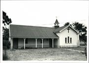
Constructed from 1886
Historic_ St Peter's Church was built in 1886 with the combined help of the settlers of the area. Some donated bricks, some roofing iron and work was done by working bees. The building was also used as a school room until classes were shifted to Broome Hill in 1893. The cairn was built by AW Burridge, foreman of the Broome Hill Roads Board and was unveiled by Mr HAA tylor, who was born on the opposite side of the road. An effort was made to move the church into Broome Hill, brick by brick, but WWII intervened and the plan was abadoned as impractical. Social- served as a school for the settler's children at Eticup.
Nothing remains of St Peter's Church site at Eticup execpt for a plaque. This was an important building as it also served as a school room.
Modifications: A vestry was added in 1898 donated by Lady Brassy. Extent of Original Fabric: 0%
Site Only
This information is provided voluntarily as a public service. The information provided is made available in good faith and is derived from sources believed to be reliable and accurate. However, the information is provided solely on the basis that readers will be responsible for making their own assessment of the matters discussed herein and are advised to verify all relevant representations, statements and information.
Ivy, Jasper, Journal and India Sts Broomehill
Includes entire block bounded by Ivy, Jasper, Journal and India Streets, together with buildings on opposite sides of India and Journal Streets facing this block. Assessment may identify additional elements adjacent that should be included.
Broomehill-Tambellup
Great Southern
| Type | Status | Date | Documents |
|---|---|---|---|
| (no listings) |
| Type | Status | Date | Documents |
|---|---|---|---|
| RHP - To be assessed | Current | 13 Aug 2004 |
| Type | Status | Date | Grading/Management | |
|---|---|---|---|---|
| Category | ||||
| (no listings) | ||||
Precinct or Streetscape
| Epoch | General | Specific |
|---|---|---|
| Original Use | COMMERCIAL | Hotel, Tavern or Inn |
| Original Use | SOCIAL\RECREATIONAL | RSL Hall |
| Original Use | GOVERNMENTAL | Other |
| Original Use | GOVERNMENTAL | Office or Administration Bldg |
| Original Use | GOVERNMENTAL | Town, Shire or District Hall |
| Original Use | RELIGIOUS | Church, Cathedral or Chapel |
| General | Specific |
|---|---|
| DEMOGRAPHIC SETTLEMENT & MOBILITY | Settlements |
| SOCIAL & CIVIC ACTIVITIES | Community services & utilities |
This information is provided voluntarily as a public service. The information provided is made available in good faith and is derived from sources believed to be reliable and accurate. However, the information is provided solely on the basis that readers will be responsible for making their own assessment of the matters discussed herein and are advised to verify all relevant representations, statements and information.
Cnr Janitor & Davine Sts Broomehill
Police Station and Court House
St Elizabeth of Hungary Anglican Church
Broomehill-Tambellup
Great Southern
Constructed from 1892 to 1953
| Type | Status | Date | Documents |
|---|---|---|---|
| Heritage List | Adopted | 21 Nov 1996 | |
| State Register | Registered | 02 Sep 1997 | HCWebsite.Listing+ListingDocument, HCWebsite.Listing+ListingDocument |
| Type | Status | Date | Documents |
|---|---|---|---|
| (no listings) |
| Type | Status | Date | Grading/Management | |
|---|---|---|---|---|
| Category | ||||
| Municipal Inventory | Adopted | 21 Nov 1996 | ||
| Classified by the National Trust | Classified | 14 Apr 1998 | ||
| Name | Type | Year From | Year To |
|---|---|---|---|
| George Temple Poole | Architect | - | - |
| Library Id | Title | Medium | Year Of Publication |
|---|---|---|---|
| 2486 | St Andrew's Anglican Church Katanning; St Andrew's Hall Katanning; St Peter's Anglican Church Badgebup; St Elizabeth's Anglican Church Broomehill : asessment of buildings and recommendations of work to be done . | Heritage Study {Other} | 1993 |
| 3769 | St Elizabeth's Church, Broomehill Roof Replacement | Heritage Study {Other} | 1998 |
| 9735 | Church of St Elizabeth of Hungary Broomehill: conservation works. | Conservation works report | 2011 |
| 8538 | St Elizabeth of Hungary Anglican Church, Broomehill. | Heritage Study {Cons'n Plan} | 2007 |
Individual Building or Group
| Epoch | General | Specific |
|---|---|---|
| Original Use | GOVERNMENTAL | Police Station or Quarters |
| Present Use | RELIGIOUS | Church, Cathedral or Chapel |
| Style |
|---|
| Vernacular |
| Type | General | Specific |
|---|---|---|
| Wall | BRICK | Rendered Brick |
| Roof | METAL | Corrugated Iron |
| General | Specific |
|---|---|
| SOCIAL & CIVIC ACTIVITIES | Religion |
This information is provided voluntarily as a public service. The information provided is made available in good faith and is derived from sources believed to be reliable and accurate. However, the information is provided solely on the basis that readers will be responsible for making their own assessment of the matters discussed herein and are advised to verify all relevant representations, statements and information.
Constructed from 1953, Constructed from 1892
Historic- The Broome Hill Police Station was built in 1892. When the new police station and quarters was built in 1951, the old station was not needed. The anglican Parish purchased the building for 450 pounds in 1952 and with a few alterations, it became a church.
Saint Elizabeth's Anglican Church, the former Police Station and Courthouse, a single-storey brick and iron building. It is one of the oldest buildings in Broomehill and contributes to the community’s sense of place. The altar is constructed of bricks from the old 1884 Eticup Church. The transformation from a police station into a church makes Saint Elizabeth's Anglican Church an uncommon structure.
This Church took it name from St Elizabeth who fed the poor of her country. Her husband was a heathen and had forbidden her to do so . One day she crept out of the palace with a basket of bread for the needy and her husband caught her. Miraculously, when he looked into the basket, it was filled with roses. When Broomehill came into being, there was no church for some years, so with the escalating costs of building a new church, it was more viable to convert the old police building.
Extent of Original Fabric: 60%
Good
| Name | Type | Year From | Year To |
|---|---|---|---|
| George Temple Poole | Architect | 1892 | - |
| Owner | Category |
|---|---|
| Roman Catholic Archbishop of Bunbury | Church Property |
This information is provided voluntarily as a public service. The information provided is made available in good faith and is derived from sources believed to be reliable and accurate. However, the information is provided solely on the basis that readers will be responsible for making their own assessment of the matters discussed herein and are advised to verify all relevant representations, statements and information.
Cnr Jasper & Ivy Sts Broomehill
Outside Shire Offices
Broomehill-Tambellup
Great Southern
Constructed from 1949
| Type | Status | Date | Documents |
|---|---|---|---|
| Heritage List | Adopted | 21 Nov 1996 |
| Type | Status | Date | Documents |
|---|---|---|---|
| (no listings) |
| Type | Status | Date | Grading/Management | |
|---|---|---|---|---|
| Category | ||||
| Statewide War Memorial Survey | Completed | 01 May 1996 | ||
| Municipal Inventory | Adopted | 21 Nov 1996 | ||
06196 Shire of Broomehill Offices & Library
Historic site
| Epoch | General | Specific |
|---|---|---|
| Original Use | MONUMENT\CEMETERY | Monument |
| Present Use | MONUMENT\CEMETERY | Monument |
| Type | General | Specific |
|---|---|---|
| Other | STONE | Granite |
| General | Specific |
|---|---|
| OUTSIDE INFLUENCES | World Wars & other wars |
This information is provided voluntarily as a public service. The information provided is made available in good faith and is derived from sources believed to be reliable and accurate. However, the information is provided solely on the basis that readers will be responsible for making their own assessment of the matters discussed herein and are advised to verify all relevant representations, statements and information.
Constructed from 1949
Historic: the Broomehill War Memorial was erected n Novemebr 1949 and was financed by public subscription and commemorates bothe World Wars. The names of the fallen in the 1914-18 war being on the souh face and those of 1939-45 war on the north.
The Broomehill War Memorial is located in front of the Broomehill Shire Offices. A Memorial Garden surrounds the site.
The unveiling was performed by Brigadier AW Potss DSO. The following year a rose garden was planted, now replaced by an ornamental garden.
Extent of Origianl Fabric: 100%
Very Good
| Owner | Category |
|---|---|
| Shire of Broomehill-Tambellup | Local Gov't |
This information is provided voluntarily as a public service. The information provided is made available in good faith and is derived from sources believed to be reliable and accurate. However, the information is provided solely on the basis that readers will be responsible for making their own assessment of the matters discussed herein and are advised to verify all relevant representations, statements and information.
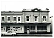
Jasper St Broomehill
Imperial Hotel
Broomehill-Tambellup
Great Southern
Constructed from 1908, Constructed from 1905
| Type | Status | Date | Documents |
|---|---|---|---|
| Heritage List | Adopted | 21 Nov 1996 |
| Type | Status | Date | Documents |
|---|---|---|---|
| RHP - To be assessed | Current | 13 Aug 2004 |
| Type | Status | Date | Grading/Management | |
|---|---|---|---|---|
| Category | ||||
| Statewide Hotel Survey | Completed | 01 Nov 1997 | ||
| Municipal Inventory | Adopted | 21 Nov 1996 | ||
12413 Broomehill Town Centre Precinct
Individual Building or Group
| Epoch | General | Specific |
|---|---|---|
| Original Use | COMMERCIAL | Hotel, Tavern or Inn |
| Present Use | COMMERCIAL | Hotel, Tavern or Inn |
| Style |
|---|
| Federation Filigree |
| Type | General | Specific |
|---|---|---|
| Roof | METAL | Corrugated Iron |
| Wall | BRICK | Other Brick |
| General | Specific |
|---|---|
| OCCUPATIONS | Hospitality industry & tourism |
This information is provided voluntarily as a public service. The information provided is made available in good faith and is derived from sources believed to be reliable and accurate. However, the information is provided solely on the basis that readers will be responsible for making their own assessment of the matters discussed herein and are advised to verify all relevant representations, statements and information.
Constructed from 1905 to 1908
Social- Broomehill has been a significant building in the fabric of Broomehill's history. Historic- Since 1889 the hotel has served the public, not only as a hotel but as a branch of the Natonal Bank was also located within the building (where the front lounge is located). If you look you can still see bars on the window where the bank was.
A two storey tuck pointed (now painted) brick and iron hotel with a triangular parapet on one elevation and simple string course parapet at the corner and side street. The building originally had two storey wrap-around verandahs in the Federation Filligree style, those to the section with the triangula parapet being slightly different in style to those to the rest of the building.
In 1889, Patrick Garrity purchased lots J1 and J2 and built a galvanised iron hotel facing Jasper Street Some time before 1905, the corner of the present hotel was built in brick (Flemish Bond). Extensions were completed in 1908 on lot J2. The hotel had the date 1908 on the new extensions.
Extent of Original Fabric: 60% Modifications: Extensive front verandah and balcony removed and modifications to the interior.
Fair
| Owner | Category |
|---|---|
| I Walton | Other Private |
This information is provided voluntarily as a public service. The information provided is made available in good faith and is derived from sources believed to be reliable and accurate. However, the information is provided solely on the basis that readers will be responsible for making their own assessment of the matters discussed herein and are advised to verify all relevant representations, statements and information.
Jasper St Broomehill
Broomehill-Tambellup
Great Southern
| Type | Status | Date | Documents |
|---|---|---|---|
| Heritage List | Adopted | 21 Nov 1996 |
| Type | Status | Date | Documents |
|---|---|---|---|
| (no listings) |
| Type | Status | Date | Grading/Management | |
|---|---|---|---|---|
| Category | ||||
| Municipal Inventory | Adopted | 21 Nov 1996 | ||
06195 Broomehill Railway Station, Ficus & Ironbark Trees
Individual Building or Group
| Epoch | General | Specific |
|---|---|---|
| Present Use | Transport\Communications | Rail: Railway Station |
| Original Use | Transport\Communications | Rail: Railway Station |
This information is provided voluntarily as a public service. The information provided is made available in good faith and is derived from sources believed to be reliable and accurate. However, the information is provided solely on the basis that readers will be responsible for making their own assessment of the matters discussed herein and are advised to verify all relevant representations, statements and information.
The place demonstrates associations with the development of the Great Southern Railway line.
The Broomehill Railway Station, although not the original building, was always located on this site. The Stationmaster's house was located across the line.
Broomehill was one of the original towns to spring up along the Great Southern Railway when it was constructed in 1889. The original railway Station was also built in that year. The copy of the old photograph included shows the activity of the station in the early 1900's.
Fair
| Owner | Category |
|---|---|
| Westrail | State Gov't |
This information is provided voluntarily as a public service. The information provided is made available in good faith and is derived from sources believed to be reliable and accurate. However, the information is provided solely on the basis that readers will be responsible for making their own assessment of the matters discussed herein and are advised to verify all relevant representations, statements and information.
Jasper St Broomehill
Broomehill-Tambellup
Great Southern
| Type | Status | Date | Documents |
|---|---|---|---|
| (no listings) |
| Type | Status | Date | Documents |
|---|---|---|---|
| (no listings) |
| Type | Status | Date | Grading/Management | |
|---|---|---|---|---|
| Category | ||||
| (no listings) | ||||
Individual Building or Group
| Epoch | General | Specific |
|---|---|---|
| Present Use | Transport\Communications | Rail: Railway Station |
| Original Use | Transport\Communications | Rail: Railway Station |
| General | Specific |
|---|---|
| TRANSPORT & COMMUNICATIONS | Rail & light rail transport |
This information is provided voluntarily as a public service. The information provided is made available in good faith and is derived from sources believed to be reliable and accurate. However, the information is provided solely on the basis that readers will be responsible for making their own assessment of the matters discussed herein and are advised to verify all relevant representations, statements and information.