Local Government
Broome
Region
Kimberley
Cable Beach Rd Cable Beach
Broome Crocodile Park
Broome
Kimberley
| Type | Status | Date | Documents |
|---|---|---|---|
| (no listings) |
| Type | Status | Date | Documents |
|---|---|---|---|
| (no listings) |
| Type | Status | Date | Grading/Management | |
|---|---|---|---|---|
| Category | ||||
| Municipal Inventory | Adopted | 27 Jun 2019 | Grading C | |
Historic Site
| General | Specific |
|---|---|
| PEOPLE | Innovators |
| OCCUPATIONS | Hospitality industry & tourism |
| DEMOGRAPHIC SETTLEMENT & MOBILITY | Settlements |
| SOCIAL & CIVIC ACTIVITIES | Sport, recreation & entertainment |
| PEOPLE | Famous & infamous people |
| DEMOGRAPHIC SETTLEMENT & MOBILITY | Environmental change |
This information is provided voluntarily as a public service. The information provided is made available in good faith and is derived from sources believed to be reliable and accurate. However, the information is provided solely on the basis that readers will be responsible for making their own assessment of the matters discussed herein and are advised to verify all relevant representations, statements and information.
• The place has historic value for the period of the 1980's when the Cable Beach area was undergoing development as a tourist destination. • The place has historic value for its association with Malcolm Douglas, a popular film maker and conservationist who established and developed the park. • The place has social value for the many members of the community who visited or worked at the park. • The buildings and structures have some historic value for their association with their former use.
The former Crocodile Park is located on two lots on the south east corner of Sanctuary Road and Cable Beach Road West. The site is largely vacant with remnant pool structures which were used for the crocodiles. Pathways through the site are still evident as are mature trees and some low plantings. There are two buildings still extant on the site in 2018; the former home of Malcolm and Valerie Douglas made of rammed earth in the south east corner of the northern lot, and the entry buildings facing Cable Beach Road West which have signage from the former use in place.
The former Crocodile Park on this site was established in 1983 by filmmaker and conservationist Malcolm Douglas (1941-2010). Malcom Douglas was well known in Australia for his very successful documentaries highlighting the wildlife and landscape of Australia. Douglas had worked as a professional crocodile hunter in the 1960's but later dedicated his career to their preservation. Malcolm Douglas produced more than 50 documentaries and films for commercial television Channels Seven and Nine. When Malcolm Douglas and his family opened the park in 1983 there were only 6 large crocodiles. Initially, new crocodiles were added to the park when captured and relocated from the wild when an individual crocodile had been a nuisance to a community. A successful breeding program was established and eventually the park held up to 4,000 crocodiles which were used for conservation and farming. The location of the Crocodile Park in Cable Beach coincided with the development of the area by Lord Alistair McAlpine who had established Cable Beach resort in the early 1980s. Malcolm Douglas and his wife Valerie lived on the premises of the Crocodile Park during the period of its operation. In 2005, Malcolm Douglas and his business partners decided to establish a wildlife park further distance from Broome which could accommodate a range of species. The Wilderness Park, which is still in operation, would slowly phase out the Crocodile Park. The transition to the Wilderness Park was hastened by the sudden death of Malcolm Douglas in 2010 when he was tragically killed in a vehicle accident. The Crocodile Park was continued by members of the Douglas family and others until 2012 when the majority of the animals were relocated. At that time it was envisaged that the grounds would be developed as an arts hub and café however these proposals did not proceed.
This information is provided voluntarily as a public service. The information provided is made available in good faith and is derived from sources believed to be reliable and accurate. However, the information is provided solely on the basis that readers will be responsible for making their own assessment of the matters discussed herein and are advised to verify all relevant representations, statements and information.
10 Millington Rd Cable Beach
Paul’s Nursery
Broome
Kimberley
| Type | Status | Date | Documents |
|---|---|---|---|
| (no listings) |
| Type | Status | Date | Documents |
|---|---|---|---|
| (no listings) |
| Type | Status | Date | Grading/Management | |
|---|---|---|---|---|
| Category | ||||
| Municipal Inventory | Adopted | 27 Jun 2019 | Grading C | |
Historic site
| General | Specific |
|---|---|
| OCCUPATIONS | Rural industry & market gardening |
| PEOPLE | Innovators |
| DEMOGRAPHIC SETTLEMENT & MOBILITY | Settlements |
| PEOPLE | Local heroes & battlers |
This information is provided voluntarily as a public service. The information provided is made available in good faith and is derived from sources believed to be reliable and accurate. However, the information is provided solely on the basis that readers will be responsible for making their own assessment of the matters discussed herein and are advised to verify all relevant representations, statements and information.
• The large garden surrounding this residence has aesthetic value as a well maintained mature garden that demonstrate a range of native and exotic species that is a landmark in the streetscape. • The garden has historic value for its associations with horticulturalist Paul Frater and botanist Tim Willing who made a significant contribution to knowledge and understanding of the physical environment of Broome and its surrounds through their establishment of a nursery on this site. • The garden has historic value for its association with the introduction of specific plant species in Broome and the wider Kimberley region that have become synonymous with the region. • The place has social value to the members of the community who visited, Paul’s Nursery as it was known, in the 1980's and 1990's. Its importance to the community was demonstrated by the community efforts taken in 2000 when storm damage threatened the survival of many of the trees.
Wavesong is a private residence located in a hectare of land close to Cable Beach. The large and well-appointed home and business premises is best known for the well maintained garden that includes exotic and native plants. Within the garden are many exotic plants that were imported to Broome in the 1980's which subsequently became popular staples within the streets and gardens of Broome. Of note is an avenue of Boab trees that was planted by Paul Frater and other Broome locals. The garden includes examples of bougainvillea, Moringa (Madagascan Boab), Desert Roses, Cordias, Tabebuia, Moses in a Basket, Cordylines, Crotons, Frangipanis, various palm varieties, African Boabs and native boabs. The residence consists of several buildings which have been built in stages from the mid-1980's and demonstrate construction methods and styling from these periods.
This property was originally part of a large landholding owned by local resident Doug Escott. In c1984, Doug Escott leased this hectare of land to local resident Paul Frater who established a nursery on the site. Paul Frater was a horticulturalist, originally from Victoria, who settled in Broome in 1978 and worked at the government nursery (Broome Tree Nursery) in Herbert Street. His work there involved the identification of plants that would survive in the North West and assist the reduction of dust in towns and increase in shade. This was part of a government policy to actively encourage settlement in the North West of WA overseen by the Department of the North West. Paul trained nursery hands at the Government Nursery during a time of great experimentation. He continued that in Paul’s Nursery with imported stock from Queensland, Northern Territory and internationally. He was joined by Tim Willing an acclaimed expert on Kimberley fauna, working as a gardener at the Shire of Broome. Tim successfully applied for a Churchill Scholarship, and travelled to Madagascar, Kenya, Zimbabwe and Mauritius, returning with plants and seeds for the northwest environment. They worked together growing their experiments at Paul’s Nursery, establishing what are now considered Broome staples: Bougainvilleas, Desert roses, Cordias, Cordylines, Crotons, Frangipanis, Palms, Boabs and more. Paul’s Nursery and home became well known in region for the diversity of plants and the friendly and knowledgeable advice from Paul Frater. In 1994, the current owners purchased the property and maintained the house and garden as a private residence. They named the property ‘Wavesong’. In 2000, Broome was struck by Cyclone Rosita and much of the garden was destroyed. With the help of friends and neighbours, the current owners rescued the garden, using heavy lifting equipment to raise many of the trees. Since that time the garden has recovered although some trees show evidence of damage with distinctive bends in their trunks.
| Reserve | Lot/Location | Plan/Diagram | Vol/Folio |
|---|---|---|---|
| 1 | 068992 | 1710/598 |
This information is provided voluntarily as a public service. The information provided is made available in good faith and is derived from sources believed to be reliable and accurate. However, the information is provided solely on the basis that readers will be responsible for making their own assessment of the matters discussed herein and are advised to verify all relevant representations, statements and information.
Sanctuary Road Cable Beach
Broome Zoo
Broome
Kimberley
| Type | Status | Date | Documents |
|---|---|---|---|
| (no listings) |
| Type | Status | Date | Documents |
|---|---|---|---|
| (no listings) |
| Type | Status | Date | Grading/Management | |
|---|---|---|---|---|
| Category | ||||
| Municipal Inventory | Adopted | 27 Jun 2019 | Grading C | |
Historic Site
| General | Specific |
|---|---|
| DEMOGRAPHIC SETTLEMENT & MOBILITY | Depression & boom |
| OCCUPATIONS | Hospitality industry & tourism |
| SOCIAL & CIVIC ACTIVITIES | Sport, recreation & entertainment |
| PEOPLE | Innovators |
| PEOPLE | Famous & infamous people |
This information is provided voluntarily as a public service. The information provided is made available in good faith and is derived from sources believed to be reliable and accurate. However, the information is provided solely on the basis that readers will be responsible for making their own assessment of the matters discussed herein and are advised to verify all relevant representations, statements and information.
• The site of the former Pearl Coast Zoo has historic value for its association with entrepreneur and businessman Lord Alistair McAlpine who made a major contribution to the development of Broome as a tourist destination. • The site has his historic value for its association with the rapid development of the tourist industry in Broome during the 1980's. • The site has social value for the members of the Broome and wider community who visited, worked there, or were aware of its presence in the outskirts of the town. • The buildings on the site constructed for the zoo have historic value for their association with the zoo.
The grounds of the former zoo are no longer visible as the majority of the property was sold and has subsequently been subdivided for residential development. Some of the buildings of the zoo originally used for the zoo have been retained and have been repurposed for other commercial functions including the Willie Creek Pearls showroom.
The Pearl Coast Zoo, or Broome Zoo, was an initiative of Lord Alistair McAlpine (1942-2014). A wealthy English businessman, entrepreneur and politician who first visited Broome in 1979. From this initial trip he enthusiastically purchased large landholdings, properties and undertook several development projects in the townsite. He purchased land at Cable Beach and oversaw the establishment of the Cable Beach Resort (Ref 52), the first luxury accommodation in the town and part of a comprehensive plan to develop Broome as a tourist destination for visitors from Australia and overseas. Following on from the resort development, McAlpine developed the Pearl Coast Zoo which reflected his passion for gardens and animals. The zoo featured natural enclosures covered approximately 60 hectares and a large wetland was the centre piece of the grounds. Movement around the grounds was largely on walkways approximately 2 meters above the ground enabling visitors to view into the enclosures. The focus of the collection was African species, particularly antelope as the climate was similar to the African environment but without endemic diseases. Native parrots were also a speciality of the collection with three large aviaries for a diverse and wide ranging collection of rare birds. The museum had a successful breeding program in several species. Despite some initial opposition from locals and some environmentalists the zoo was initially a success. However, a number of factors, including economic recession and the Pilot strike in 1989, lead to the demise of McAlpine’s Broome assets and the zoo closed c1991.
This information is provided voluntarily as a public service. The information provided is made available in good faith and is derived from sources believed to be reliable and accurate. However, the information is provided solely on the basis that readers will be responsible for making their own assessment of the matters discussed herein and are advised to verify all relevant representations, statements and information.
Cape Leveque
Broome
Kimberley
Constructed from 1970
| Type | Status | Date | Documents |
|---|---|---|---|
| (no listings) |
| Type | Status | Date | Documents |
|---|---|---|---|
| (no listings) |
| Type | Status | Date | Grading/Management | |
|---|---|---|---|---|
| Category | ||||
| Municipal Inventory | Adopted | 30 Jun 1996 | Criterion 3A | |
Historic site
| Epoch | General | Specific |
|---|---|---|
| Present Use | Transport\Communications | Comms: Other |
| Original Use | Transport\Communications | Comms: Other |
| Type | General | Specific |
|---|---|---|
| Other | METAL | Other Metal |
| General | Specific |
|---|---|
| TRANSPORT & COMMUNICATIONS | Telecommunications |
This information is provided voluntarily as a public service. The information provided is made available in good faith and is derived from sources believed to be reliable and accurate. However, the information is provided solely on the basis that readers will be responsible for making their own assessment of the matters discussed herein and are advised to verify all relevant representations, statements and information.
Constructed from 1956, Constructed from 1955
Relay Station is a landmark on the coast. It provides an essential telecommunications function and has operated continuously, with change and development, since the late1960s.
Outpost radio stations came into being in 1935 through Darwin Radio, to provide radio communication for pastoral stations and missions in the north-west. The stations became part of the Outpost Radio Service during World War Two, handling emergency communications and spoken telegrams for the pastoral stations and missions and supplementing the communication facilities of the Royal Flying Doctor Service network. Outpost Radio Service continued to operate after the War, and the operation of the Service through Broome was handled by the staff at the Overseas Telecommunications Commission (OTC) Station (see Broome Bowling Club) despite this not being an official OTC function. By late 1960s, international telecommunications were being transmitted via satellite and the OTC stations in Western Australia were superseded by the Intelsat earth station at Carnarvon. With the closure of the Broome OTC Station, Outpost Radio Service was provided with an automatic relay station at Cape Leveque. Others were situated at Derby and Port Hedland.
| Ref ID No | Ref Name | Ref Source | Ref Date |
|---|---|---|---|
| Shire of Broome's Municipal Inventory. | 1996 | ||
| Heritage Council:" Assessment Documentation place 298" | |||
| "The Australian Encyclopedia". | 1983 |
This information is provided voluntarily as a public service. The information provided is made available in good faith and is derived from sources believed to be reliable and accurate. However, the information is provided solely on the basis that readers will be responsible for making their own assessment of the matters discussed herein and are advised to verify all relevant representations, statements and information.
Cygnet Bay
Cape Leveque Rd, Dampier Peninsula 6725
Broome
Kimberley
Constructed from 1946
| Type | Status | Date | Documents |
|---|---|---|---|
| Heritage List | Adopted | 28 Aug 2014 |
| Type | Status | Date | Documents |
|---|---|---|---|
| (no listings) |
| Type | Status | Date | Grading/Management | |
|---|---|---|---|---|
| Category | ||||
| Municipal Inventory | Adopted | 28 Aug 2014 | Grading B | |
Landscape
| Style |
|---|
| Vernacular |
| Type | General | Specific |
|---|---|---|
| Wall | CONCRETE | Other Concrete |
| Roof | METAL | Corrugated Iron |
| Wall | STONE | Local Stone |
| General | Specific |
|---|---|
| OCCUPATIONS | Fishing & other maritime industry |
| SOCIAL & CIVIC ACTIVITIES | Environmental awareness |
This information is provided voluntarily as a public service. The information provided is made available in good faith and is derived from sources believed to be reliable and accurate. However, the information is provided solely on the basis that readers will be responsible for making their own assessment of the matters discussed herein and are advised to verify all relevant representations, statements and information.
Constructed from 1946
Cygnet Bay Pearl Farm demonstrates three generations of the Brown family in continuous innovative operation in the South Sea Pearling Industry.
The expansive site comprises a variety of operations, with staff accommodation, maintenance operations and the café/showrooms located in a small settlement. Several kilometres away on the coast, is a range of accommodation including a variety of luxury tent accommodations, as well as some original ‘divers’ quarters’ buildings including a stone house. The evidence of bagged construction remains with a small dwelling, water tank and the construction of a jetty/dock of Diver Side Lagoon in the mangrove creek where there is also some evidence of the remains of a lugger. Within the broader bay area are the sites of the Shenton Bluff lugger camp and cemetery, and the Diver’s side Cygnet Bay homestead.
Shenton Bluff lugger camp and cemetery was established as a pearlers’ camp in c.1885. it has continued as a pearling base since that time, with over 35 graves to testify to the history. In 1946 Australia’s oldest operating pearl farm at Cygnet Bay was established by Dean Murdoch Brown. In the 1940’s and 50’s his business was concerned with the collection of mother-of-pearl shell. This all changed in the late 50’s when Dean’s sons revolutionized the industry. Lyndon, strove to perfect the art of pearl cultivation and eventually unlocked the secret of seeding a pearl shell, a technique previously known only by the Japanese. Lyndon’s brother, Bruce, and his wife Alison soon joined the venture introducing the first non-hard hat diver to the industry in the 60’s. Together, the brothers designed and built what was unique to the industry then, a fibreglass lugger. The 1960s paperbark homestead is central to the history of the development of the pearl farm in the later half of the twentieth century. The world’s largest fine quality round South Sea pearl was nurtured in the rich and sheltered waters of Cygnet Bay Pearl Farm. Measuring 22.24mm in diameter, it has taken many decades to produce. The gem has a 70 mm circumference, is white/pink in colour and weighs 156 grams. Rosario Autore, founder and CEO of Autore, an international wholesaler of South Sea Pearls says, ‘The pearl’s estimated worth is priceless, as it is the only one of its size and quality in the world to our knowledge.’ In 2012, Cygnet Bay pearl farm is home to three generations of the Brown family. The family owned operation has operated continuously since 1946, forging a niche in the South Sea pearling industry.
Moderate degree (water tank, Jetty) High degree
Fair/good
| Ref ID No | Ref Name | Ref Source | Ref Date |
|---|---|---|---|
| www.cygnetbaypearls.com.au | |||
| Documentation provided by James Brown. | |||
| Interview with James Brown on site | 04/2012 |
| Ref Number | Description |
|---|---|
| No.56 | MI Place No. |
This information is provided voluntarily as a public service. The information provided is made available in good faith and is derived from sources believed to be reliable and accurate. However, the information is provided solely on the basis that readers will be responsible for making their own assessment of the matters discussed herein and are advised to verify all relevant representations, statements and information.
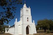
Beagle Bay Dampier Peninsula
Sacred Heart Church
Broome
Kimberley
Constructed from 1915 to 1918
| Type | Status | Date | Documents |
|---|---|---|---|
| Heritage List | Adopted | 28 Aug 2014 | |
| State Register | Registered | 07 Apr 1998 | HCWebsite.Listing+ListingDocument, HCWebsite.Listing+ListingDocument |
| Type | Status | Date | Documents |
|---|---|---|---|
| (no listings) |
| Type | Status | Date | Grading/Management | |
|---|---|---|---|---|
| Category | ||||
| Classified by the National Trust | Classified | 09 Oct 2000 | ||
| Aboriginal Heritage Sites Register | Permanent | |||
| Municipal Inventory | Adopted | 28 Aug 2014 | Grading A | |
| Classified by the National Trust | Classified | 09 Oct 2000 | ||
| Name | Type | Year From | Year To |
|---|---|---|---|
| Fr Thomas Bachmair | Architect | - | - |
| Library Id | Title | Medium | Year Of Publication |
|---|---|---|---|
| 7458 | From patrons to partners : a history of the catholic Church in the Kimberley 1884 - 1984. | Book | 1994 |
| 5371 | Sacred Heart Church Beagle Bay WA : structural report | Report | 2002 |
| 5751 | Sacred Heart Church Beagle Bay : reconstruction of belltower and rendering (final report). | Conservation works report | 2002 |
| 4150 | Reroofing of the Sacred Heart Church, Beagle Bay: Final Report 1999 Conservation Works. | Heritage Study {Other} | 1999 |
| 4772 | Conservation plan for Sacred Heart Church (1918) (Beagle Bay Mission Church) : Beagle Bay : Western Australia. | Heritage Study {Cons'n Plan} | 1998 |
| 7599 | Havens of refuge : a history of leprosy in Western Australia. | Book | 1978 |
| 4642 | Conservation plan for Sacred Heart Church (1918) : (Beagle Bay Mission Church), Beagle Bay, Western Australia | Heritage Study {Cons'n Plan} | 1998 |
| 9466 | Signposts: a guide for children and young people in care in WA from 1920. | Electronic | 2010 |
| 8335 | Historic buildings of the Kimberley region of W.A. | Book | 1988 |
Individual Building or Group
| Epoch | General | Specific |
|---|---|---|
| Present Use | RELIGIOUS | Church, Cathedral or Chapel |
| Original Use | RELIGIOUS | Church, Cathedral or Chapel |
| Style |
|---|
| Inter-War Gothic |
| Type | General | Specific |
|---|---|---|
| Wall | TIMBER | Other Timber |
| Roof | METAL | Corrugated Iron |
| Wall | BRICK | Handmade Brick |
| General | Specific |
|---|---|
| SOCIAL & CIVIC ACTIVITIES | Religion |
This information is provided voluntarily as a public service. The information provided is made available in good faith and is derived from sources believed to be reliable and accurate. However, the information is provided solely on the basis that readers will be responsible for making their own assessment of the matters discussed herein and are advised to verify all relevant representations, statements and information.
Constructed from 1918
Sacred Heart Mission Church is of considerable significance for the associations with the Aboriginals of Beagle Bay and the Pallotine Brothers. The place is of aesthetic significance for the vernacular style, the use of local made bricks, and mother of pearl detailing on the altar and shell work throughout. The place is a significant place of worship, community events and social gatherings in Beagle Bay, and is a tourism attraction to the region.
Set in an open expansive grassed area, the building is stunning. The impressive church building has a gable roof with a three-storey square bell tower over the central front entry. The entry/tower has a stepped recessed gothic entrance and a high spire central on top. The whitewashed handmade brick construction has stepped buttresses along both sides and the two front corners step into pinnacles each side. The windows and openings are gothic arches. The altar and all other ecclesiastical motifs are made of shells and mother of pearl inlays in traditional European and Aboriginal motifs.
In 1890, the French Trappist Order established a Catholic mission for the local people a few kilometres inland of Beagle Bay. The Trappists built a church, monastery and dormitories of paperbark and attempted to make the Mission self-supporting but with little success. Because the Trappists were a contemplative vocation, the work of running a Mission did not suit their way of life. The Trappists left the Mission in 1900 and the German Pallotine Brothers took over. In 1907, nine Sisters of St John of God arrived to assist with their work. The Aboriginal boys were trained in various crafts and trades and the girls were taught to be housekeepers and seamstresses. During World War One, the Brothers were confined to the Mission and spent their time building a new church with considerable help from the Aboriginal population who collected timber and large amounts of shell, which was burnt down to produce white lime for mortar and plaster, as well as assisting to make the 60,000 double bricks. They were also involved in decorating the interior of the church. The Beagle Bay Mission Church was dedicated on 15 August 1918. The ceiling was installed in 1920 and in 1949, Sister Roswina of the German Schoenstatt Sisters painted the Stations of the Cross, which hang in the Church. Beagle Bay Mission developed into a thriving community with numerous buildings, including dormitories, school, domestic science block, dining room, hall, butcher, bakery and store. Over the years, the Mission adjusted to the changes in Government policy toward Aboriginal people until in 1976, the Beagle Bay Aboriginal Community was issued with a 99-year lease on 600,000 acres of land surrounding the Mission.
High degree High degree
Good although rising damp damage is evident
| Ref ID No | Ref Name | Ref Source | Ref Date |
|---|---|---|---|
| Conservation Plan 1998 |
| Ref Number | Description |
|---|---|
| No.53 | MI Place No. |
This information is provided voluntarily as a public service. The information provided is made available in good faith and is derived from sources believed to be reliable and accurate. However, the information is provided solely on the basis that readers will be responsible for making their own assessment of the matters discussed herein and are advised to verify all relevant representations, statements and information.
Constructed from 1915 to 1918
The place has a high degree of aesthetic value, both internally and externally, and exhibits a well resolved combination of architectural, symbolic and artistic motives. The church is an outstanding example of creative use of local resources for both construction and decorative purpose. The place illustrates the early European occupation of a previously isolated portion of the state. The place is closely associated with the work of missionaries and attempts to induct Aboriginal people into the Christian faith. It is highly valued by the mission community for their considerable involvement in its establishment and contributes to their sense of place. The continuing use of the place for religious activities enhances the social value. The place is a rare example of a religious building combining a high value of construction and artistic excellence in a remote setting. The place has a landmark quality, with its central location within the collection of mission buildings. The wide grassed area surrounding the Church enhances its prominence and contributes to its landmark quality.
Beagle Bay Mission Church, located in the Shire of Broome, is of clay brick construction. The style classification of Beagle Bay Mission Church in Inter-War Gothic, although the church is a very simple form of Gothic design that reflects the austere conditions and limited resources available at the time of construction. Beagle Bay Mission Church is orientated on the traditional east-west axis, with the entry to the west end of the building under a three level bell tower crowned with a spire and crucifix. The nave is a long rectangular space with a central aisle and timber pews arranged each side of the aisle. This nave east wall is crowned externally with a small tower, spire, orb and crucifix, and has pinnacles at each end. The sanctuary in the east end of the church has two side rooms for a sacristy and altar boys dressing/service room. These two side rooms have gable end walls to the north and south ends, and like the other walls of the church are securely buttressed both for strength and appearance. 'Clay' bricks made on site were used for the construction of the walls. Inspection of a sample brick available revealed that they are relatively light in weight. The roof over the nave is formed from three sheets of 'corrugated iron' from ridge to gutter.
Beagle Bay Mission Church, also known as the Sacred Heart Church, was constructed between 1915 and 1918 by the Pallottine Brothers and Aboriginal residents of Beagle Bay Mission. The Mission takes its name from nearby Beagle Bay which was named in 1838 by Lieutenant L. Stokes after the H.M.S. Beagle, the ten gun brig on which he sailed. Works there included the construction of a small church and monastery in 1891. On 15 August 1918, on the Feast of the Assumption of Our Lady, Beagle Bay Mission Church was dedicated by Father Creagh, the Apostolic Administrator of the Kimberley Vicariate, to the Sacred Heart of Jesus. In 1930, Beagle Bay Mission was 'a thriving religious community', home to hundreds of Aboriginal children who lived in dormitories and attended the church school. In 1949, Bishop Otto Raible commissioned Sister Roswina, a religious sister belonging to the order of the Institute of the Schoenstatt Sisters in Germany, to design and paint the Stations of the Cross for the Beagle Bay Mission Church. In 1959, Father John Jobst succeeded Bishop Raible and Beagle Bay Mission entered a new phase of activity. An energetic building program was undertaken in the early 1960s, including a school (1960), a dormitory, dining room, domestic science block and a new store (1964). Beagle Bay Aboriginal Community was issued with a 99 year lease title for land comprising 600 000 acres in September 1976.
The church retains high integrity and authenticity, having fulfilled and sustained its religious function since construction, with few alterations to the form of the building.
Beagle Bay Mission Church is in sound to poor condition.
| Name | Type | Year From | Year To |
|---|---|---|---|
| Father Thomas Bachmair | Architect | 1915 | 1918 |
| Reserve | Lot/Location | Plan/Diagram | Vol/Folio |
|---|---|---|---|
| 1 | 12362 | 1635, 756 |
This information is provided voluntarily as a public service. The information provided is made available in good faith and is derived from sources believed to be reliable and accurate. However, the information is provided solely on the basis that readers will be responsible for making their own assessment of the matters discussed herein and are advised to verify all relevant representations, statements and information.
L 100 & 3001 Broome-Cape Leveque Rd Dampier Peninsula
Cape Leveque
Broome
Kimberley
Constructed from 1911, Constructed from 1909
| Type | Status | Date | Documents |
|---|---|---|---|
| Heritage List | Adopted | 28 Aug 2014 | |
| State Register | Registered | 28 Aug 2001 | HCWebsite.Listing+ListingDocument, HCWebsite.Listing+ListingDocument |
| Type | Status | Date | Documents |
|---|---|---|---|
| (no listings) |
| Type | Status | Date | Grading/Management | |
|---|---|---|---|---|
| Category | ||||
| Aboriginal Heritage Sites Register | Permanent | |||
| Lighthouses Survey | Completed | 01 May 2000 | ||
| Municipal Inventory | Adopted | 28 Aug 2014 | Grading A | |
| Name | Type | Year From | Year To |
|---|---|---|---|
| Public Works Dept | Architect | - | - |
| Library Id | Title | Medium | Year Of Publication |
|---|---|---|---|
| 7183 | Lighthouses of Australia : images from the end of an era. | Book | 2001 |
| 4582 | The Australian Maritime Safety Authority : lighthouse conservation assessment : Cape Leveque : Broome : Western Australia. | Heritage Study {Other} | 2000 |
| 5942 | Conservation analysis of 13 lighthouse properties. | C D Rom | 2000 |
Individual Building or Group
| Epoch | General | Specific |
|---|---|---|
| Original Use | Transport\Communications | Water: Lighthouse |
| Present Use | Transport\Communications | Water: Lighthouse |
| Type | General | Specific |
|---|---|---|
| Wall | METAL | Cast Iron |
| General | Specific |
|---|---|
| TRANSPORT & COMMUNICATIONS | River & sea transport |
This information is provided voluntarily as a public service. The information provided is made available in good faith and is derived from sources believed to be reliable and accurate. However, the information is provided solely on the basis that readers will be responsible for making their own assessment of the matters discussed herein and are advised to verify all relevant representations, statements and information.
Constructed from 1911, Constructed from 1966, Constructed from 1985, Constructed from 1965
Cape Leveque Lighthouse is a significant landmark on the isolated coast, and continues to function as a lighthouse.
The lighthouse is situated on a rocky outcrop in a fenced yard. The whitewashed circular building tapers to an external steel bracketed perimeter deck off the top element that is mostly glazed to facilitate the beacon light from within. The apex has a metal dome. The design of the prefabricated cast iron lighthouse tower is finely conceived and executed. The tower 43 feet (13.1m) high.
Cape Leveque lighthouse was commissioned on 9 August 1911, and was one of ten lighthouses built on the West Australian coast between 1900 and 1913, most of them on the North West coast. At this time, the provision of lighthouses was still the responsibility of the State, but the control of all coastal lights passed into Commonwealth hands in 1915. Cape Leveque lighthouse tower was manufactured in Perth. Construction of the lighthouse and associated quarters cost £9,219. The lighthouse was fitted with a third order, dioptric triple flashing white light, which was visible for 18 nautical miles in fine weather. The light was fuelled by kerosene and the lighthouse was manned by two light keepers. The tower is the only prefabricated cast iron lighthouse designed by the Public Works Department and manufactured locally by Bela Makutz .The RAAF had a base near the lighthouse during World War Two, and an airstrip was built nearby in 1955. The lighthouse was modernised in 1965/66 with a new light and a non-directional radio beacon and the old quarters were replaced with two steel-framed, two-storey residences. The original light was given to the WA Museum. In 1985, the lighthouse was converted to solar power and automated, with a new light. A Racon beacon was installed. This beacon has a range of between 10 and 20 miles, less than a radio beacon, and is used by ships equipped with radar.
High degree High degree
Good
| Ref ID No | Ref Name | Ref Source | Ref Date |
|---|---|---|---|
| Considine & Griffihs Architects Pty Ltd | Lighthouse Conservation Assessment Cape Leveque, Broome | 2000 |
| Ref Number | Description |
|---|---|
| No.54 | MI Place No. |
| Reserve | Lot/Location | Plan/Diagram | Vol/Folio |
|---|---|---|---|
| 1 | 70354 |
This information is provided voluntarily as a public service. The information provided is made available in good faith and is derived from sources believed to be reliable and accurate. However, the information is provided solely on the basis that readers will be responsible for making their own assessment of the matters discussed herein and are advised to verify all relevant representations, statements and information.
Lombadina Dampier Peninsula
comprises: Christ the King Church, Presbytery, fmr Convent & Cemetery
Broome
Kimberley
Constructed from 1934, Constructed from 1913
| Type | Status | Date | Documents |
|---|---|---|---|
| Heritage List | Adopted | 28 Aug 2014 | |
| State Register | Registered | 15 May 1998 | HCWebsite.Listing+ListingDocument, HCWebsite.Listing+ListingDocument |
| Type | Status | Date | Documents |
|---|---|---|---|
| (no listings) |
| Type | Status | Date | Grading/Management | |
|---|---|---|---|---|
| Category | ||||
| Register of the National Estate | Nominated | 25 Sep 1985 | ||
| Aboriginal Heritage Sites Register | Permanent | |||
| Classified by the National Trust | Classified | 01 Jun 1985 | ||
| Register of the National Estate | Indicative Place | |||
| Municipal Inventory | Adopted | 28 Aug 2014 | Grading A | |
| Classified by the National Trust | Classified | 04 Jun 1985 | ||
A fire on 12 August 2006 has destoryed the former Convent building (1913).
| Library Id | Title | Medium | Year Of Publication |
|---|---|---|---|
| 8335 | Historic buildings of the Kimberley region of W.A. | Book | 1988 |
| 5120 | Conservation plan for Christ the King Church, Presbytery (former), St John of God Convent (former) & Cemetery, Lombadina, Western Australia / prepared by John Taylor Architect for the Bishop of Broome. | Heritage Study {Cons'n Plan} | 1998 |
| 11518 | Lombadina Mission : photographic archival record | Archival Record | 2017 |
| 9466 | Signposts: a guide for children and young people in care in WA from 1920. | Electronic | 2010 |
Individual Building or Group
| Epoch | General | Specific |
|---|---|---|
| Other Use | RELIGIOUS | Housing or Quarters |
| Other Use | RELIGIOUS | Church, Cathedral or Chapel |
| Original Use | RELIGIOUS | Monastery or Convent |
| Present Use | SOCIAL\RECREATIONAL | Other Community Hall\Centre |
| Style |
|---|
| Inter-War California Bungalow |
| Type | General | Specific |
|---|---|---|
| Wall | STONE | Local Stone |
| Wall | TIMBER | Other Timber |
| Wall | METAL | Corrugated Iron |
| Roof | METAL | Corrugated Iron |
| General | Specific |
|---|---|
| PEOPLE | Aboriginal people |
| DEMOGRAPHIC SETTLEMENT & MOBILITY | Racial contact & interaction |
| SOCIAL & CIVIC ACTIVITIES | Religion |
This information is provided voluntarily as a public service. The information provided is made available in good faith and is derived from sources believed to be reliable and accurate. However, the information is provided solely on the basis that readers will be responsible for making their own assessment of the matters discussed herein and are advised to verify all relevant representations, statements and information.
Constructed from 1920, Constructed from 1934, Constructed from 1915
Lombadina Mission is of considerable significance for the associations with the local Aboriginal people and the Pallotine Brothers. The place is of aesthetic significance for the vernacular style, the use of local materials. The place is a significant place of worship and social gathering.
The Church and Presbytery is a bush timber framed detailed on the exterior with vertical corrugated iron cladding. The hipped roof is framed in bush timbers with corrugated iron cladding. The surrounding verandahs are roofed at break pitch. The interior ceiling lining in the church has exposed bush timber and paperbark lining. The floors are timber. The Cemetery has the remains of a low concrete block wall and evidences several graves with various markers. Mostly overgrown.
The Lombadina pastoral property was purchased by Catholic Bishop Matthew Gibney in 1891 to supplement the landholding the Beagle Bay Mission and help make the mission self-supporting, but the land was of poor quality and useless for the purpose. The Trappist Order (1890-1900) and then the Pallotines ran the Beagle Bay Mission. The Pallotines sold the Lombadina property to Manilaman Thomas Peutollano. He built up a herd of cattle and established a garden, supplying pearling lugger crews. In 1910, he asked former Trappist Father Nicolas Elmo to establish an outpost of the Beagle Bay mission on his property to administer to the 100 or so Bardi people who were gathered there. Father Nicolas established a church in 1912 and three Sisters of St John of God from Beagle Bay joined him in 1913. The early buildings at Lombadina Mission were of paperbark. Father Nicolas died in 1915 and the Pallotine Brothers from Beagle Bay took over management, buying back the property in 1918. A bush Church was built in 1934 by Brother Joseph Tautz and a school was added in 1937. Between 1959 and 1963, a new school, hospital, dining hall and housing facilities were added. Over the years the Mission adjusted to the changes in Government policy toward Aboriginal people until in 1984, the property was transferred to the Lombadina Aboriginal Community.
High degree High degree
Church- Fair; Presbytery- poor; Cemetery-Fair
| Ref ID No | Ref Name | Ref Source | Ref Date |
|---|---|---|---|
| HCWA assessment documentation |
| Ref Number | Description |
|---|---|
| No.52 | MI Place No. |
This information is provided voluntarily as a public service. The information provided is made available in good faith and is derived from sources believed to be reliable and accurate. However, the information is provided solely on the basis that readers will be responsible for making their own assessment of the matters discussed herein and are advised to verify all relevant representations, statements and information.
Constructed from 1932
Though of late construction, the buildings are of interest architecturally as aesthetically pleasing structures designed to suit the climate and to accommodate the dictates of the local materials and the demands of unskilled labour. The mission plays an important part in the history of the state concerning the arrival of foreign missionaries with the aim of "saving the Aborigine and bestowing the benefits of civilisation and religion and thus to set them on their feet". Lombadina also played a part in the treatment of Aborigines during the leprosy epidemic.
The buildings date from 1932. The church is built of round mangrove trunks of a variety of sizes in accordance with the function each is put to, such as slender members for rafters and heavier trunks for floor joists. The walls are of vertical boards and the ceiling of bark. Over the bark galvanised corrugated iron is fixed. The floor is of timber and is raised on stumps a metre or so above the ground. There are large verandah-like overhangs on each side of the building. Wide openings at intervals along the nave open onto these. At the west end of the church the nave has been made slightly wider and the roof is pitched at a steeper pitch to form an elevated mounting for the bell. The entrance is sheltered by a large verandah raised to main floor level and surrounded by a balustrade of mangrove trunk hand rails and criss-cross mangrove trunk infill. The presbytery is of similar construction to that of the church, consisting of a rectangle block divided into a series of partitions with central openings after the style of a railway coach. There are verandahs on each long side of the building. The convent is a U-shaped conventionally built corrugated galvanised iron clad cottage-like structure. The cemetery consists of an arrangement of simple graves marked with wooden crosses.
This information is provided voluntarily as a public service. The information provided is made available in good faith and is derived from sources believed to be reliable and accurate. However, the information is provided solely on the basis that readers will be responsible for making their own assessment of the matters discussed herein and are advised to verify all relevant representations, statements and information.
Dartnall
Broomehill-Tambellup
Great Southern
| Type | Status | Date | Documents |
|---|---|---|---|
| (no listings) |
| Type | Status | Date | Documents |
|---|---|---|---|
| (no listings) |
| Type | Status | Date | Grading/Management | |
|---|---|---|---|---|
| Category | ||||
| Municipal Inventory | Adopted | 16 Sep 1998 | ||
Individual Building or Group
| Epoch | General | Specific |
|---|---|---|
| Present Use | Transport\Communications | Rail: Other |
| Original Use | Transport\Communications | Rail: Other |
| General | Specific |
|---|---|
| TRANSPORT & COMMUNICATIONS | Rail & light rail transport |
This information is provided voluntarily as a public service. The information provided is made available in good faith and is derived from sources believed to be reliable and accurate. However, the information is provided solely on the basis that readers will be responsible for making their own assessment of the matters discussed herein and are advised to verify all relevant representations, statements and information.
| Owner | Category |
|---|---|
| Westrail | State Gov't |
This information is provided voluntarily as a public service. The information provided is made available in good faith and is derived from sources believed to be reliable and accurate. However, the information is provided solely on the basis that readers will be responsible for making their own assessment of the matters discussed herein and are advised to verify all relevant representations, statements and information.
56 Great Northern Hwy Eighty Mile Beach
Located off Gt.Nthn Hwy, 260km S/W of Broome and 220km E/N/E of P/Hedland
Broome
Kimberley
Constructed from 1900
| Type | Status | Date | Documents |
|---|---|---|---|
| Heritage List | Adopted | 28 Aug 2014 | |
| State Register | Registered | 08 Jan 2021 | HCWebsite.Listing+ListingDocument, HCWebsite.Listing+ListingDocument |
| Type | Status | Date | Documents |
|---|---|---|---|
| (no listings) |
| Type | Status | Date | Grading/Management | |
|---|---|---|---|---|
| Category | ||||
| Classified by the National Trust | Classified | 05 Jun 1984 | ||
| Register of the National Estate | Nominated | 15 Oct 1984 | ||
| Register of the National Estate | Indicative Place | |||
| Municipal Inventory | Adopted | 28 Aug 2014 | Grading A | |
Wallal Downs Station Group comprises a small complex of utilitarian sheds and farm buildings and residential buildings surrounded by open landscape. The structures date from the 1920s through to the present, with a number of later cyclone rated residential and operations structures built after the devastation of Cyclone Laurence in 2009. The main homestead building (Homestead) and adjacent ablutions block, Kitchen, and Single Quarters (North), are located in a cluster in the eastern side of the group. The group is separated from the garage building and car parking area to the west by a fence. A small fenced grave site with marble headstone is located approximately 80 metres north of the Married Quarters building. It is the only known grave site on the station and is dedicated ‘In Loving Memory of Geoffrey Wyndham. Husband of Margaret, Father of Alex, Marjorie, Alward (sic) and Frank. Died 11th August 1952’.
Wallal Downs Station Group comprises a small collection of stone buildings and structures, archaeological deposits and structural remains dating from the 1920s as well as more recent permanent and temporary buildings and sheds, which form part of the homestead complex associated within the large 600,000 acre pastoral station of Wallal Downs, the southernmost station in the Kimberley region. The station originally grazed sheep but is now a cattle station. The first lease of Wallal Downs Station and homestead was taken up in about 1900 by Messrs Piper and Galbraith who were bought out by Somerset in 1910. In the early 1920s a syndicate of ten returned soldiers bought the sheep station property. The stone section of the Homestead dates from c. 1922, as do two of the Stone Water Tanks and the aqueduct. In 1922 the station comprised six white men, including the owner/managers Davidson, Lacey and King, and approximately fifty Aboriginal men and women. In late 1922 Wallal Downs Station briefly became internationally significant due to its location along the path of totality of a solar eclipse. In August and September 1922, Wallal Station was the site of an important scientific astronomic expedition led by the University of California’s Lick Observatory and including contingents from Australia, the University of Toronto, India, and a private party from England. In June 1928, it was reported that the Wallal Downs Station Homestead had been destroyed by fire, and the original 1900 structure was used as the homestead. During WWII, the isolation of the place meant it was under threat from Japanese attack and invasion. Two Flying Dornier Boats flying Dutch refugees fleeing Java landed at Wallal, having lost their way to Broome, and subsequently avoided the Flying Boats Massecre there. The refugees were hosted at Wallal station for four days before they could fly on to safety. Following the death of Reg King in 1973, the remaining members of the syndicate surrendered the lease of the property. In December 2009, Eighty Mile Beach and Wallal Downs Station were hit by a category 5 storm, Cyclone Laurence. The storm wrought severe damage across the Kimberley and along the Pilbara coastline, including considerable damage to the Wallal Downs Station. Several buildings were completely destroyed during the storm, including the ‘Old Stone Building (Ruins)’ and the shearers' kitchen/dining room, and others required considerable repair works. The structural debris and rubble was removed by machinery soon after the cyclone to reduce the snake hazard.
| Name | Type | Year From | Year To |
|---|---|---|---|
| Association to | Architect | - | - |
| Library Id | Title | Medium | Year Of Publication |
|---|---|---|---|
| 8335 | Historic buildings of the Kimberley region of W.A. | Book | 1988 |
Individual Building or Group
| Epoch | General | Specific |
|---|---|---|
| Original Use | FARMING\PASTORAL | Servants or Shearers Quarters |
| Present Use | FARMING\PASTORAL | Homestead |
| Original Use | FARMING\PASTORAL | Homestead |
| Present Use | FARMING\PASTORAL | Servants or Shearers Quarters |
| Other Use | MONUMENT\CEMETERY | Grave |
| Type | General | Specific |
|---|---|---|
| Other | METAL | Corrugated Iron |
| Other | STONE | Limestone |
| Other | STONE | Other Stone |
| General | Specific |
|---|---|
| OCCUPATIONS | Grazing, pastoralism & dairying |
This information is provided voluntarily as a public service. The information provided is made available in good faith and is derived from sources believed to be reliable and accurate. However, the information is provided solely on the basis that readers will be responsible for making their own assessment of the matters discussed herein and are advised to verify all relevant representations, statements and information.
Constructed from 1920
Wallal Downs Station Group comprising the limestone, weatherboard and iron Homestead (1900, 1929), Cottage (former Married Quarters) (c. 1952), three Stone Water Tanks (1922) and a stone Aqueduct (1922) as well as archaeological remnants associated with earlier stone buildings and single quarters (c.1900, 1920), has cultural heritage significance for the following reasons: • The place was a site of an internationally important scientific expedition to observe the 1922 total solar eclipse. The data recorded from the site was at the time the most accurate measured and was pivotal in confirming Albert Einstein’s General Theory of Relativity. • Some of the buildings and ruins on site were built by a successful syndicate of World War I ex-servicemen as part of the Solider Settlement Scheme. • The place reflects the fear of Japanese invasion during World War II, particularly in the isolated north-west. • The place hosted Dutch refugees who landed in Dornier Flying Boast at Eighty Mile Beach having fled the Japanese invasion of Java. • The place has potential to contain archaeological deposits or artefacts that can provide information that can contribute to understanding of rural life during the 19th century. • The place was home to many Nyangumarta people who lived and worked at the Station over many years and has social value for their families and descendants for whom the station is located on Native Title land. • The place is a representative example of the transition of pastoral stations from running sheep to cattle in the state’s north west during the mid-twentieth century.
Wallal Downs Station comprises the homestead &outbuildings including stone water tanks. The buildings are mostly limestone constructions with the use of some coral rock. The roofs are corrugated iron.
Wallal Downs Station was the first land taken up on the 80-mile beach, with a lease issued about 1900 to Piper and Galbraith. They were joined in partnership by Charles Somerset of Pardoo, who bought them out in 1910. In the 1920s, a syndicate of ten returned soldiers acquired the property under the Soldier Settlement Scheme. The active partners in the group were the two Lacey brothers and Reg King who were responsible for the early stone buildings, including the stone section of the residence, the shearers' kitchen-dining room and two of the tanks. In 1973, following the death of Reg King, the remaining members of the syndicate sold the property.
Moderate
The main Homestead building and other residential buildings are in good condition. The Aqueduct and Stone Water Tanks are in sound condition, with some repair works undertaken to cracking. A number of buildings have been completely destroyed due to cyclone damage.
| Ref ID No | Ref Name | Ref Source | Ref Date |
|---|---|---|---|
| HCWA assessment documentation |
| Ref Number | Description |
|---|---|
| No.57 | MI Place No. |
| Reserve | Lot/Location | Plan/Diagram | Vol/Folio |
|---|---|---|---|
| 9697 | 56 | 240321 | 3127/125 |
This information is provided voluntarily as a public service. The information provided is made available in good faith and is derived from sources believed to be reliable and accurate. However, the information is provided solely on the basis that readers will be responsible for making their own assessment of the matters discussed herein and are advised to verify all relevant representations, statements and information.
Constructed from 1922
Taken up early in the century (20th), Wallal was the first station on the 80 mile beach. It is of interest that about 1920 it was purchased by a group of 1914- 1918 war veterans under the Returned Soldiers Resettlement Scheme (not generally applied to pastoral leases) and was bought by the present owner (after the death of Reg King) in 1937 from the remaining members of that syndicate. The structures from local limestone are of interest.
Homestead Group: homestead, kitchen block,water tanks, shearing shed. Much of the original stonework to homestead, kitchen block, water tanks etc remains. Re-roofing to homestead and kitchen block necessary after cyclones. Upgrading of verandah areas. The first lease of Wallal Downs station, with its homestead, less than 5 kms from the 80 mile beach was taken up about 1900 by Messrs Piper and Gailbraith who were joined in partnership by Charles Somerset, an Englishman then working at Pardoo, and were eventually bought out by him in 1910. Somerset remained until early in the 1920's when a syndicate of ten returned soldiers bought the property, the active partners being the two Lacey brothers and Reg King, who were responsible for much of the early stone work. The stone section of the house dates from c.1922 as do the shearers kitchen/dining room and two of the tanks. Roof structures were often replaced following cyclone damage.
Assessment July 1982
This information is provided voluntarily as a public service. The information provided is made available in good faith and is derived from sources believed to be reliable and accurate. However, the information is provided solely on the basis that readers will be responsible for making their own assessment of the matters discussed herein and are advised to verify all relevant representations, statements and information.
Great Northern Hwy Goldsworthy
Broome
Kimberley
| Type | Status | Date | Documents |
|---|---|---|---|
| (no listings) |
| Type | Status | Date | Documents |
|---|---|---|---|
| (no listings) |
| Type | Status | Date | Grading/Management | |
|---|---|---|---|---|
| Category | ||||
| Register of the National Estate | Registered | 27 Mar 2001 | ||
Landscape
| Epoch | General | Specific |
|---|---|---|
| Original Use | OTHER | Other |
| General | Specific |
|---|---|
| DEMOGRAPHIC SETTLEMENT & MOBILITY | Aboriginal Occupation |
| SOCIAL & CIVIC ACTIVITIES | Sport, recreation & entertainment |
This information is provided voluntarily as a public service. The information provided is made available in good faith and is derived from sources believed to be reliable and accurate. However, the information is provided solely on the basis that readers will be responsible for making their own assessment of the matters discussed herein and are advised to verify all relevant representations, statements and information.
Jam Creek Rd Jam Creek
Broomehill-Tambellup
Great Southern
| Type | Status | Date | Documents |
|---|---|---|---|
| (no listings) |
| Type | Status | Date | Documents |
|---|---|---|---|
| (no listings) |
| Type | Status | Date | Grading/Management | |
|---|---|---|---|---|
| Category | ||||
| Municipal Inventory | Adopted | 16 Sep 1998 | ||
Other Built Type
| Epoch | General | Specific |
|---|---|---|
| Original Use | FARMING\PASTORAL | Other |
| Present Use | FARMING\PASTORAL | Other |
| General | Specific |
|---|---|
| OCCUPATIONS | Grazing, pastoralism & dairying |
This information is provided voluntarily as a public service. The information provided is made available in good faith and is derived from sources believed to be reliable and accurate. However, the information is provided solely on the basis that readers will be responsible for making their own assessment of the matters discussed herein and are advised to verify all relevant representations, statements and information.
Jam Creek sheep wash pool.
This information is provided voluntarily as a public service. The information provided is made available in good faith and is derived from sources believed to be reliable and accurate. However, the information is provided solely on the basis that readers will be responsible for making their own assessment of the matters discussed herein and are advised to verify all relevant representations, statements and information.
Kimberley
The Kimberley
Wyndham-East Kimberley
Kimberley
| Type | Status | Date | Documents |
|---|---|---|---|
| National Heritage List | YES | 31 Aug 2011 |
| Type | Status | Date | Documents |
|---|---|---|---|
| (no listings) |
| Type | Status | Date | Grading/Management | |
|---|---|---|---|---|
| Category | ||||
| (no listings) | ||||
Large Conservation Region
| Epoch | General | Specific |
|---|---|---|
| Original Use | OTHER | Other |
This information is provided voluntarily as a public service. The information provided is made available in good faith and is derived from sources believed to be reliable and accurate. However, the information is provided solely on the basis that readers will be responsible for making their own assessment of the matters discussed herein and are advised to verify all relevant representations, statements and information.
La Grange
La Grange
Broome
Kimberley
| Type | Status | Date | Documents |
|---|---|---|---|
| Heritage List | Adopted | 28 Aug 2014 |
| Type | Status | Date | Documents |
|---|---|---|---|
| (no listings) |
| Type | Status | Date | Grading/Management | |
|---|---|---|---|---|
| Category | ||||
| Municipal Inventory | Adopted | 28 Aug 2014 | Grading B | |
Individual Building or Group
This information is provided voluntarily as a public service. The information provided is made available in good faith and is derived from sources believed to be reliable and accurate. However, the information is provided solely on the basis that readers will be responsible for making their own assessment of the matters discussed herein and are advised to verify all relevant representations, statements and information.
Constructed from 1955
The Catholic Mission at La Grange is significant in informing of the history of mission settlements and government policies regarding the relocation of Aboriginal people from their traditional Homelands and the provision of minimal essentials.
The Catholic Mission at La Grange was established in 1955 as an adjunct to the Pallotine Missions at Beagle Bay and Lombadina. Aboriginal people were moved to La Grange from the surrounding pastoral properties by the police, where they were housed in Nissan huts and provided with the bare essentials of food, clothing and blankets.
High degree ? High degree ?
| Ref ID No | Ref Name | Ref Source | Ref Date |
|---|---|---|---|
| OH2695/37-40, interviews | Aboriginal women in the Kimberleys by Christine Choo |
| Ref Number | Description |
|---|---|
| No.55 | MI Place No. |
This information is provided voluntarily as a public service. The information provided is made available in good faith and is derived from sources believed to be reliable and accurate. However, the information is provided solely on the basis that readers will be responsible for making their own assessment of the matters discussed herein and are advised to verify all relevant representations, statements and information.
Broome Rd to Roebuck Plains Station Lake Eda
Broome
Kimberley
| Type | Status | Date | Documents |
|---|---|---|---|
| (no listings) |
| Type | Status | Date | Documents |
|---|---|---|---|
| (no listings) |
| Type | Status | Date | Grading/Management | |
|---|---|---|---|---|
| Category | ||||
| Municipal Inventory | Adopted | 28 Aug 2014 | Grading C | |
Landscape
| Epoch | General | Specific |
|---|---|---|
| Original Use | Transport\Communications | Water: Other |
This information is provided voluntarily as a public service. The information provided is made available in good faith and is derived from sources believed to be reliable and accurate. However, the information is provided solely on the basis that readers will be responsible for making their own assessment of the matters discussed herein and are advised to verify all relevant representations, statements and information.
The Billabong at lake Eda is of great cultural importance to the traditional owners, Yawuru Aboriginal Community, who visit to hunt and maintain cultural customs.
Lake Eda is the largest and most permanent of a chain of six lakes that occur in the extensive coastal floodplain in the area known as Roebuck Plains. The Billabong Lake at Lake Eda is of great cultural importance to the traditional owners, Yawuru Aboriginal community, who visit to hunt and maintain cultural customs
| Ref ID No | Ref Name | Ref Source | Ref Date |
|---|---|---|---|
| Livesey, N.J., Harris, J., & Brash, S.J. | Roebuck Plains and Associated Wetland System | ||
| Murdoch University |
| Ref Number | Description |
|---|---|
| No.59 | MI Place No. |
This information is provided voluntarily as a public service. The information provided is made available in good faith and is derived from sources believed to be reliable and accurate. However, the information is provided solely on the basis that readers will be responsible for making their own assessment of the matters discussed herein and are advised to verify all relevant representations, statements and information.
281 Kavite Rd Minyirr
Reddell Beach
Bethlehem Retreat
Broome
Kimberley
| Type | Status | Date | Documents |
|---|---|---|---|
| (no listings) |
| Type | Status | Date | Documents |
|---|---|---|---|
| (no listings) |
| Type | Status | Date | Grading/Management | |
|---|---|---|---|---|
| Category | ||||
| Municipal Inventory | Adopted | 27 Jun 2019 | Grading C | |
Historic site
| Epoch | General | Specific |
|---|---|---|
| Present Use | RELIGIOUS | Housing or Quarters |
| Original Use | RELIGIOUS | Housing or Quarters |
| General | Specific |
|---|---|
| SOCIAL & CIVIC ACTIVITIES | Religion |
| SOCIAL & CIVIC ACTIVITIES | Community services & utilities |
| PEOPLE | Aboriginal people |
| SOCIAL & CIVIC ACTIVITIES | Sport, recreation & entertainment |
| PEOPLE | Local heroes & battlers |
This information is provided voluntarily as a public service. The information provided is made available in good faith and is derived from sources believed to be reliable and accurate. However, the information is provided solely on the basis that readers will be responsible for making their own assessment of the matters discussed herein and are advised to verify all relevant representations, statements and information.
Constructed from 1953 to 1970
• The site has historic value for its association with the Sisters of St John of God who operated an orphanage in Broome from the early 1940's to 1962. • The site has social value for the members of the community who attended the place as a holiday cottage in the 1950's and 1960's, predominantly the girls who attended the Holy Child Orphanage and Sisters of the St John of God. The extant buildings on the site have no cultural heritage significance.
A group of several detached single storey houses within a fenced setting on the coastline. All evidence of the original buildings on the site has been removed.
The lot on which these buildings are located was first leased to the Sisters of St John of God in 1955 by the State Government. The Sisters of St John of God established the Holy Child Orphanage for girls in the Broome townsite during the early 1940's. The majority of the girls were from the local aboriginal population. The purpose of the acquisition of the lot at Reddell Beach was to provide a summer cottage for the girls. The Sisters named the block Bethlehem after the birthplace of Jesus. Mother Margaret engaged local builder, Jacob Sesar to construct a simple dormitory block and a pit toilet. All the materials for the building were recycled from other sites. For many years after World War Two building materials were in short supply therefore recycling was an economic necessity. The dormitory could only accommodate half of the population of girls from the orphanage, therefore during holidays each girl would have the opportunity to spend half of the holidays at the beach with one of two sisters accompanying them. Conditions at Bethlehem Retreat were basic with no running water or electricity but recollections from some of the girls who went on these holidays recall it as a positive experience with simple pleasures such as fishing and bush walks, and time away from studies. It is understood that on occasion girls from Broome who did not live at the orphanage also went to Bethlehem Retreat. Travelling to the retreat was challenging as the car the Sisters owned was not big enough for all of the girls so a scheme was devised to take one group half way and then drop them off to walk the remainder of the distance whilst the truck returned to pick up the other group. Alternatively the smaller children would get a ride while the larger children walked. Later the Sisters acquired a larger truck to transport all the girls. The Holy Child Orphanage in Broome was closed in 1962. The lease for the site was transferred to the Diocese of Broome in 1963. Aerial photographs indicate that the original buildings on the site were removed after this transfer and new buildings have been subsequently constructed on the site.
| Reserve | Lot/Location | Plan/Diagram | Vol/Folio |
|---|---|---|---|
| 700 | 209491 | 1403/371 |
| Owner | Category |
|---|---|
| Roman Catholic Bishop of Broome | Church Property |
This information is provided voluntarily as a public service. The information provided is made available in good faith and is derived from sources believed to be reliable and accurate. However, the information is provided solely on the basis that readers will be responsible for making their own assessment of the matters discussed herein and are advised to verify all relevant representations, statements and information.
286 Port Dr Minyirr, Broome
These buildings are located within the boundary of the Port of Broome.
Port of Broome
Broome
Kimberley
Constructed from 1927
| Type | Status | Date | Documents |
|---|---|---|---|
| Heritage List | Adopted | 28 Aug 2014 |
| Type | Status | Date | Documents |
|---|---|---|---|
| RHP - Assessed - Consultation (Preliminary) | Current | 22 Aug 1997 |
| Type | Status | Date | Grading/Management | |
|---|---|---|---|---|
| Category | ||||
| Municipal Inventory | Adopted | 28 Aug 2014 | Grading B | |
06720 Port of Broome
Individual Building or Group
| Epoch | General | Specific |
|---|---|---|
| Present Use | GOVERNMENTAL | Other |
| Present Use | RESIDENTIAL | Single storey residence |
| Present Use | MILITARY | Other |
| Original Use | GOVERNMENTAL | Quarantine Station |
| Style |
|---|
| North-West Vernacular |
| Type | General | Specific |
|---|---|---|
| Roof | METAL | Corrugated Iron |
| Wall | TIMBER | Other Timber |
| General | Specific |
|---|---|
| DEMOGRAPHIC SETTLEMENT & MOBILITY | Government policy |
| TRANSPORT & COMMUNICATIONS | River & sea transport |
| SOCIAL & CIVIC ACTIVITIES | Community services & utilities |
| DEMOGRAPHIC SETTLEMENT & MOBILITY | Racial contact & interaction |
This information is provided voluntarily as a public service. The information provided is made available in good faith and is derived from sources believed to be reliable and accurate. However, the information is provided solely on the basis that readers will be responsible for making their own assessment of the matters discussed herein and are advised to verify all relevant representations, statements and information.
Constructed from 1920
Quarantine station houses are significant in demonstrating ways of life and associations with Quarantine officers and their families, and the indentured pearler workers, as well as and World War Two associations, and that of Bill Reed and Linney’s Pearls.
The three residences are separate, with two located in close proximity to each other, and the other one on the bay side of the road some several hundred metres away. The places are mostly concealed from the road. The place comprises three single-storey buildings including an administration bock, an isolation hospital and the Quarantine Assistants quarters. These three buildings have been converted for use as private residences. The former isolation hospital is in a lawned and landscaped setting surrounded by established plants and trees including a large boab tree. The building is timber framed and raised on concrete stumps. It comprises 3 adjoining rooms and is similar in shape and size to the former admin block. The hipped roof covers the verandahs. The former Quarantine Assistant's Quarters is similar in design to the former isolation hospital. The building is timber framed with a hipped roof and is raised on concrete stumps, comprises three rooms of equal size. The verandah on the southwest corner is enclosed to form an emergency room for a female nurse. The place is now used as a residence.
Quarantine stations were established at ports of entry to detect and isolate people with communicable diseases, notably cholera, yellow fever, smallpox, plague and typhus fever. Quarantine stations were established at isolated locations away from towns. Locations near the sea, especially on peninsulas, were considered most suitable as it was believed their would be less chance of spreading the disease inland and any 'foul air' would be blown out to sea. This type of location also made it easier to control access. After Federation, Quarantine became a Federal responsibility with the passing of the Quarantine Act, 1908. The area at Entrance Point was established as a reserve for quarantine around this time. The buildings were added in the 1920s, following the establishment of the Commonwealth Dept of Health, which administered the Quarantine Act. The Doctors and Administrators of the Quarantine Station were accommodated in the houses. The Quarantine Station housed indentured Asian labourers recruited into the pearling industry, where they were kept for several months before being allowed into Broome town. The Quarantine buildings at Entrance Point were used by the army during World War Two, and have more recently been used as private residences. In 1951, it was recorded that the Quarantine Station comprised a hospital with 2 wards, Quarantine Assistant’s quarters, and administration building. The Commonwealth Government had no further use for the buildings and disposed of them to the Broome Historical Society on the basis that the Historical Society would relocate the buildings. In 1981, the Broome Historical Society advised they could not comply, and the houses were leased out.
High degree High degree
Fair/good
| Ref ID No | Ref Name | Ref Source | Ref Date |
|---|---|---|---|
| Documentation provided by William Reed | 2012 | ||
| L Gray & I Sauman | Heritage Assessment | 2004 |
| Ref Number | Description |
|---|---|
| No.47 | MI Place No. |
| Reserve | Lot/Location | Plan/Diagram | Vol/Folio |
|---|---|---|---|
| 28650 | 6, 12 & 13 |
This information is provided voluntarily as a public service. The information provided is made available in good faith and is derived from sources believed to be reliable and accurate. However, the information is provided solely on the basis that readers will be responsible for making their own assessment of the matters discussed herein and are advised to verify all relevant representations, statements and information.
Cnr Bessen & Moonies Hill Rds Moonies Hill
Broomehill-Tambellup
Great Southern
Constructed from 1906
| Type | Status | Date | Documents |
|---|---|---|---|
| (no listings) |
| Type | Status | Date | Documents |
|---|---|---|---|
| RHP - Does not warrant assessment | Current | 13 Mar 2020 |
| Type | Status | Date | Grading/Management | |
|---|---|---|---|---|
| Category | ||||
| Municipal Inventory | Adopted | 16 Sep 1998 | ||
Historic Site
| Epoch | General | Specific |
|---|---|---|
| Original Use | EDUCATIONAL | Primary School |
| Present Use | EDUCATIONAL | Primary School |
| General | Specific |
|---|---|
| SOCIAL & CIVIC ACTIVITIES | Education & science |
This information is provided voluntarily as a public service. The information provided is made available in good faith and is derived from sources believed to be reliable and accurate. However, the information is provided solely on the basis that readers will be responsible for making their own assessment of the matters discussed herein and are advised to verify all relevant representations, statements and information.
Constructed from 1906
School with living quarters.
Site Only
This information is provided voluntarily as a public service. The information provided is made available in good faith and is derived from sources believed to be reliable and accurate. However, the information is provided solely on the basis that readers will be responsible for making their own assessment of the matters discussed herein and are advised to verify all relevant representations, statements and information.
cnr Bessen & Moonies Hill Rds Moonies Hill
Broomehill-Tambellup
Great Southern
| Type | Status | Date | Documents |
|---|---|---|---|
| (no listings) |
| Type | Status | Date | Documents |
|---|---|---|---|
| RHP - Does not warrant assessment | Current | 13 Mar 2020 |
| Type | Status | Date | Grading/Management | |
|---|---|---|---|---|
| Category | ||||
| Municipal Inventory | Adopted | 16 Sep 1998 | ||
12379 Moonies Hill School - Site & Moreton Bay Fig Tree
Tree
| Epoch | General | Specific |
|---|---|---|
| Original Use | OTHER | Other |
This information is provided voluntarily as a public service. The information provided is made available in good faith and is derived from sources believed to be reliable and accurate. However, the information is provided solely on the basis that readers will be responsible for making their own assessment of the matters discussed herein and are advised to verify all relevant representations, statements and information.
Planted at Moonies Hill Scool site.
Good
This information is provided voluntarily as a public service. The information provided is made available in good faith and is derived from sources believed to be reliable and accurate. However, the information is provided solely on the basis that readers will be responsible for making their own assessment of the matters discussed herein and are advised to verify all relevant representations, statements and information.
Multiple LGAs
The track stretches from Broomehill to Coolgardie, over numerous shires and includes soaks, tanks, springs, rock catchments, camps, native wells and many natural landmarks such as hills, trees and outcrops
Broomehill-Tambellup
Great Southern
Constructed from 1893
| Type | Status | Date | Documents |
|---|---|---|---|
| (no listings) |
| Type | Status | Date | Documents |
|---|---|---|---|
| RHP - Assessment in Progress | Current | 14 Feb 2022 |
| Type | Status | Date | Grading/Management | |
|---|---|---|---|---|
| Category | ||||
| (no listings) | ||||
Holland’s Track marks a significant event in the Western Australian Gold Boom of the 1890s as its cutting created a direct route from Broomhill to the Goldfields, which enabled communication and transportation with the south-western portion of the colony in Albany and allowed for travelling prospectors from the eastern states to directly access the Goldfields via their initial docking point in Albany.
Holland’s Track was fundamental in the development of Coolgardie Townsite enabling supplies to be transported from Albany and the eastern states.
Holland’s Track is the life’s achievement of Richard John Holland, who never received any formal acknowledgment or compensation for his work, and who is memorialised in the various landmarks along the route that still bear the original names he gave them.
Holland’s Track was an important access road for the development of wheat-farming properties in the 1920s.
Holland’s Track is a major recreational tourist route for four-wheel drive travellers in Western Australia who specifically travel on the route to experience the original journey John Holland and his companions took.
Holland’s Track marks a significant event in the Western Australian Gold Boom of the 1890s as its cutting created a direct route from Broomhill to the Goldfields, which enabled communication and transportation with the south-western portion of the colony in Albany and allowed for travelling prospectors from the eastern states to directly access the Goldfields via their initial docking point in Albany. Holland’s Track is the life’s achievement of Richard John Holland, who never received any formal acknowledgment or compensation for his work, and who is memorialised in the various landmarks along the route that still bear the original names he gave them. Holland’s Track was an important access road for the development of wheat-farming properties in the 1920s. Holland’s Track is a major recreational tourist route for four-wheel drive travellers in Western Australia who specifically travel on the route to experience the original journey John Holland and his companions took.
John Holland, in his 1906 Report, which was later published in the Coolgardie Miner on 1 October 1936, outlined the distance he travelled as 320 miles from Broomehill to Coolgardie. This equates to roughly 515 kilometres. The current Holland Track which is well-documented and mapped for tourists is roughly 680 kilometres. The tourist route identified as Holland’s Track extends roughly 680 kilometres north-east from the Broomehill townsite to Coolgardie. It traverses a variety of differing native bush landscapes and runs through farming, pastoral and mining areas. This track runs approximately along the original route that was cut by John Holland in 1893. Overall the tourist route is predominately true to the historical route apart from some exceptions in the southern portion of the track after Nampup and close to the end of the track leading up to Victoria Rock. The southern and northern sections of the tourist track differ in accessibility for vehicles. The southern section, which is referred to as John Holland Way, is suitable for two-wheel drive travel along both sealed and unsealed roads, while the northern section, which veers off from John Holland Way at Emu Rock, Kondinin, is four-wheel drive only. The northern portion of the track was re-cut in 1992 as part of the celebrations of the Holland Track centenary. Along the track are a series of prominent landmarks that were named and recorded by John Holland on his initial trek. These landmarks are important markers for those travelling.
On the 17th September 1892, the discovery of gold 120 miles east of Southern Cross initiated a rush that attracted prospectors from across the country. Men in Albany and surrounds were keen to join the rush after it was initially announced in September 1892. Several parties attempted to cut a track towards the Goldfields straight away, with the aim to shorten the journey by two to three weeks. However, none were successful and all unanimously described the land as impenetrable. Despite this, and despite the increasing words of warning, John Holland, a sandalwood cutter local to the area, was not deterred and was confident a track could be cut in a small number of months. As a leaseholder in the area and an experienced bushman who had travelled across the land in search of sandalwood, Holland knew how to locate water and survive expeditions into the local landscape. He therefore felt confident he could successfully locate the best route to the goldfields and cut a track in relatively good time. Holland had been planning his expedition since the initial discovery of gold in September 1892. He was eager to begin straight away, but unlike others who attempted the feat before him he knew the summer months were approaching and it would be the worst time to set off. Holland instead waited until a cooler time of year and gathered a team together in the meantime. Joining John Holland were three local men, John Carmody, David Krakouer and his brother Rudolph Krakouer, who was the financer of the expedition and second in command. The official starting point for the expedition was Broomehill, which was already easily accessible from Albany along the Great Southern Railway. It was from here that the men gathered equipment for their 680 kilometre trek, which included ‘five W.A. ponies, a light dray, a 100 gallon tank [of water], and from five to six months provisions‘. The party, led by Holland, set off from Broomehill for Bayley’s Rush (Coolgardie) on the 14th April, 1893. The group had covered around 680 kilometres in two months and four days, cutting the longest cart road in Western Australia at that time and lessening the journey from Albany by a fortnight. Despite this achievement John Holland and his companions received no official acknowledgement and no compensation from the Government. Their only solace was the knowledge that the track enabled thousands of prospectors, both local and from the eastern States, to travel easily from the southern portion of the State. The track was in regular use up until March 1896 when the railway line from Fremantle was extended to Coolgardie and officially opened on the 23rd of that month. As the new extension connected Fremantle Port, supplies and travellers arriving in Western Australia were easily transported by train and Holland’s Track became a secondary route that was rarely travelled. Furthermore, with the onset of WWI, mining declined significantly and so people were less inclined to travel to the Goldfields. Today the two portions of Holland’s Track are used regularly by 4WD enthusiasts and holidaymakers.
Good
Precinct or Streetscape
| Epoch | General | Specific |
|---|---|---|
| Original Use | Transport\Communications | Road: Other |
| General | Specific |
|---|---|
| DEMOGRAPHIC SETTLEMENT & MOBILITY | Resource exploitation & depletion |
| OCCUPATIONS | Mining {incl. mineral processing} |
| TRANSPORT & COMMUNICATIONS | Road transport |
This information is provided voluntarily as a public service. The information provided is made available in good faith and is derived from sources believed to be reliable and accurate. However, the information is provided solely on the basis that readers will be responsible for making their own assessment of the matters discussed herein and are advised to verify all relevant representations, statements and information.