Local Government
Fremantle
Region
Metropolitan
122 Stirling Hwy North Fremantle
Fremantle
Metropolitan
| Type | Status | Date | Documents |
|---|---|---|---|
| Heritage List | YES | 08 Mar 2007 |
| Type | Status | Date | Documents |
|---|---|---|---|
| (no listings) |
| Type | Status | Date | Grading/Management | |
|---|---|---|---|---|
| Category | ||||
| Municipal Inventory | Adopted | 18 Sep 2000 | Level 3 | |
Individual Building or Group
| Epoch | General | Specific |
|---|---|---|
| Present Use | RESIDENTIAL | Single storey residence |
| Original Use | RESIDENTIAL | Single storey residence |
| Style |
|---|
| Victorian Georgian |
| Type | General | Specific |
|---|---|---|
| Roof | METAL | Corrugated Iron |
| Wall | STONE | Limestone |
| Wall | BRICK | Common Brick |
| General | Specific |
|---|---|
| DEMOGRAPHIC SETTLEMENT & MOBILITY | Land allocation & subdivision |
This information is provided voluntarily as a public service. The information provided is made available in good faith and is derived from sources believed to be reliable and accurate. However, the information is provided solely on the basis that readers will be responsible for making their own assessment of the matters discussed herein and are advised to verify all relevant representations, statements and information.
Constructed from 1921, Constructed from 1900
22385 North Fremantle Precinct
House, 122 Stirling Highway, is a typical rendered masonry and iron single storey cottage dating from the early 1900s. The place has aesthetic value for its contribution to the streetscape and the surrounding area. It is representative of the typical building stock located within the residential areas of North Fremantle. Historically significant as a representation of typical workers' houses in the North Fremantle area. The place is a simple example of the Victorian Georgian style of architecture.
House, 122 Stirling Highway, is a single storey rendered masonry and iron cottage with symmetrical facade designed as a late example of the Victorian Georgian style of architecture. Walls are rendered and painted masonry. Roof is hipped corrugated iron with no eaves. Verandah is under broken back corrugated iron roof. Verandah is supported by timber posts with decorative timber brackets. Front elevation is symmetrical with two timber double hung sash windows with curved lintels and a central front door with top and side lights. There is a timber picket fence to the front boundary line. A Heritage Assessment was prepared in Aug 2009 by Philip Griffiths Architects for a DA submission to Council (DA0310/09) for removal of the rear addition and construction of a new rear addition.
The portion of Stirling Highway to the north of Queen Victoria Street was originally part of Perth Road. The area developed with mixed residential, commercial and industrial uses from the 1860s following the construction of the North Fremantle Traffic Bridge and the upgrading of Perth Road by convicts. The portion of Stirling Highway that runs between the Swan River and the junction with Queen Victoria Street was formerly called Bruce Street. It was named after Colonel Bruce, head of the Pensioner Guards. In the early days of North Fremantle’s development, the favoured residential area for settlement was slightly west of the North Fremantle oval and named ‘Brucetown’. Settlement of North Fremantle began in earnest in the late 1890s and Bruce Street was characterised by a mix of building types. On the southern side of the street between Queen Victoria Street (formerly Perth Road) and Tydeman Road (formerly Pensioner Road and then John Street), the buildings were predominantly residential. Industrial use was more common on the northern side. Stirling Bridge was constructed across the Swan River at the end of Bruce Street in 1974. As Bruce Street was now the major arterial link between the bridge and Stirling Highway, the street was widened and renamed as an extension of Stirling Highway. In recent years, new high-density residential development of the areas adjacent to the river on either side of Stirling Highway has seen a significant change in the mix of buildings in the southern section of Stirling Highway. In 2004, the street continues to have a mix of residential, retail and industrial land use. House, 122 Stirling Highway was built at some time between c. 1900 and 1921/22, when George Harvey was recorded as being the owner and occupier. The following year, the title was passed to Phillip Harvey, who resided there until 1927/28. At this time John Adams bought the four room brick house, and held it as a rental property until his death in the early 1930s. Alfred Augustus Pozzi then purchased the property and remained in residence until at least 1964. After 1968, Mrs Vida Pozzi, an old age pensioner, is listed as the occupant. Alfred Pozzi died in 1974, and his wife inherited the house. She later remarried and became Mrs Vida Tapper. In 2003/04, the house at 122 Stirling Highway was held by her estate. A 1939 diagram shows House, 122 Stirling Highway as a brick house with a full length front verandah and a centrally located path leading from the street to the front of the house. The yard was heavily paved to the north and at the rear of the house. Rear access to the house was gained via a laneway off Pamment Street. This place was included in the 'North Fremantle Heritage Study' (1994) as a place contributing to the development and heritage of North Fremantle. It was also included in the list of heritage places in the City of Fremantle identified by the Fremantle Society (1979/80) - BROWN -significant for making a positive contribution to the built environment of Fremantle. A Heritage Assessment was prepared in Aug 2009 by Philip Griffiths Architects for a DA submission to Council (DA0310/09) for removal of the rear addition and construction of a new rear addition.
High degree of integrity (original intent clear, current use compatible, high long term sustainability, restored). High degree of authenticity with much original fabric remaining. (These statements based on street survey only).
Condition assessed as good (assessed from streetscape survey only).
This information is provided voluntarily as a public service. The information provided is made available in good faith and is derived from sources believed to be reliable and accurate. However, the information is provided solely on the basis that readers will be responsible for making their own assessment of the matters discussed herein and are advised to verify all relevant representations, statements and information.
123 Stirling Hwy North Fremantle
Fremantle
Metropolitan
| Type | Status | Date | Documents |
|---|---|---|---|
| (no listings) |
| Type | Status | Date | Documents |
|---|---|---|---|
| (no listings) |
| Type | Status | Date | Grading/Management | |
|---|---|---|---|---|
| Category | ||||
| Municipal Inventory | Adopted | 14 Dec 2016 | Historical Record Only | |
Individual Building or Group
| Epoch | General | Specific |
|---|---|---|
| Original Use | COMMERCIAL | Warehouse |
This information is provided voluntarily as a public service. The information provided is made available in good faith and is derived from sources believed to be reliable and accurate. However, the information is provided solely on the basis that readers will be responsible for making their own assessment of the matters discussed herein and are advised to verify all relevant representations, statements and information.
Constructed from 1946
22385 North Fremantle Precinct
DEMOLISHED. Retained on MHI for historical information only.
The portion of Stirling Highway to the north of Queen Victoria Street was originally part of Perth Road. The area developed with mixed residential, commercial and industrial uses from the 1860s following the construction of the North Fremantle Traffic Bridge and the upgrading of Perth Road by convicts. The portion of Stirling Highway that runs between the Swan River and the junction with Queen Victoria Street was formerly called Bruce Street. It was named after Colonel Bruce, head of the Pensioner Guards. In the early days of North Fremantle’s development, the favoured residential area for settlement was slightly west of the North Fremantle oval and named ‘Brucetown’. Settlement of North Fremantle began in earnest in the late 1890s and Bruce Street was characterised by a mix of building types. On the southern side of the street between Queen Victoria Street (formerly Perth Road) and Tydeman Road (formerly Pensioner Road and then John Street), the buildings were predominantly residential. Industrial use was more common on the northern side. Stirling Bridge was constructed across the Swan River at the end of Bruce Street in 1974. As Bruce Street was now the major arterial link between the bridge and Stirling Highway, the street was widened and renamed as an extension of Stirling Highway. In recent years, new high-density residential development of the areas adjacent to the river on either side of Stirling Highway has seen a significant change in the mix of buildings in the southern section of Stirling Highway. In 2004, the street continues to have a mix of residential, retail and industrial land use. House, 123 Stirling Highway was constructed c. 1946/47 for Edward R. Price, who lived there for a number of years. Prior to this, the vacant land had a succession of owners (most notably several owners of 122 Stirling Highway). From 1974, 123 Stirling Highway was owned by R.E. Arnold & Co Pty Ltd, who then passed the title to Mate and Mike Santich in 1977. The place was held by Simpla Plastics Pty Ltd in 2003/04. It is not known when the house was demolished. On 11/2/1970 a building licence (No. 5878) was submitted to Council for the erection of a temporary office and showroom on Lot 5 of P100/101. It was erected for Nolex Engineering at an estimated cost of $2,100 and occupied by Alumcraft Boats. The temporary nature of the building was due to the fact that the land was going to be resumed for the widening of Stirling Highway, so the building would have to re-located at a future date. According to Building Department records the building was completed by 25/6/1970.
| Ref ID No | Ref Name | Ref Source | Ref Date |
|---|---|---|---|
| MI not adopted - DEMOLISHED- retained on MHI database for historical information purposes only. |
This information is provided voluntarily as a public service. The information provided is made available in good faith and is derived from sources believed to be reliable and accurate. However, the information is provided solely on the basis that readers will be responsible for making their own assessment of the matters discussed herein and are advised to verify all relevant representations, statements and information.
13 Stirling Hwy North Fremantle
Fremantle
Metropolitan
| Type | Status | Date | Documents |
|---|---|---|---|
| Heritage List | YES | 08 Mar 2007 |
| Type | Status | Date | Documents |
|---|---|---|---|
| (no listings) |
| Type | Status | Date | Grading/Management | |
|---|---|---|---|---|
| Category | ||||
| Municipal Inventory | Adopted | 18 Sep 2000 | Level 3 | |
Individual Building or Group
| Epoch | General | Specific |
|---|---|---|
| Present Use | RESIDENTIAL | Single storey residence |
| Original Use | RESIDENTIAL | Single storey residence |
| Style |
|---|
| Victorian Georgian |
| Type | General | Specific |
|---|---|---|
| Roof | METAL | Corrugated Iron |
| Wall | TIMBER | Weatherboard |
| General | Specific |
|---|---|
| DEMOGRAPHIC SETTLEMENT & MOBILITY | Land allocation & subdivision |
This information is provided voluntarily as a public service. The information provided is made available in good faith and is derived from sources believed to be reliable and accurate. However, the information is provided solely on the basis that readers will be responsible for making their own assessment of the matters discussed herein and are advised to verify all relevant representations, statements and information.
Constructed from 1897, Constructed from 1913
House, 13 Stirling Highway, is a typical weatherboard and iron single storey cottage dating from the 1890s. The place has aesthetic value for its contribution to the streetscape and the surrounding area. It is representative of the typical building stock located within the residential areas of North Fremantle. Historically significant as a representation of typical workers' houses in the North Fremantle area. The place is a very late simple example of the Victorian Georgian style of architecture.
House, 13 Stirling Highway, is a single storey weatherboard and iron cottage with symmetrical facade designed as a late example of the Victorian Georgian style of architecture. Walls are timber framed clad with weatherboards. Roof is hipped corrugated iron with no eaves. Verandah has been removed. Front elevation is symmetrical with two timber sash windows and a central front door. There is a limestone wall to the front boundary.
The portion of Stirling Highway to the north of Queen Victoria Street was originally part of Perth Road. The area developed with mixed residential, commercial and industrial uses from the 1860s following the construction of the North Fremantle Traffic Bridge and the upgrading of Perth Road by convicts. The portion of Stirling Highway that runs between the Swan River and the junction with Queen Victoria Street was formerly called Bruce Street. It was named after Colonel Bruce, head of the Pensioner Guards. In the early days of North Fremantle’s development, the favoured residential area for settlement was slightly west of the North Fremantle oval and named ‘Brucetown’. Settlement of North Fremantle began in earnest in the late 1890s and Bruce Street was characterised by a mix of building types. On the southern side of the street between Queen Victoria Street (formerly Perth Road) and Tydeman Road (formerly Pensioner Road and then John Street), the buildings were predominantly residential. Industrial use was more common on the northern side. Stirling Bridge was constructed across the Swan River at the end of Bruce Street in 1974. As Bruce Street was now the major arterial link between the bridge and Stirling Highway, the street was widened and renamed as an extension of Stirling Highway. In recent years, new high-density residential development of the areas adjacent to the river on either side of Stirling Highway has seen a significant change in the mix of buildings in the southern section of Stirling Highway. In 2004, the street continues to have a mix of residential, retail and industrial land use. The weatherboard and tile cottage at 13 Stirling Highway (formerly 12 Bruce Street) was built between 1897 and 1913 for an unidentified owner. It was part of a larger landholding owned by Mrs Andrew Burns in 1895 and subdivided circa 1896. In 1921, the property was described as a five roomed wooden house owned by Percy Cross and occupied by James Winstone. Percy Cross continued to own the property and lease it to a variety of tenants until 1935. Information is not available for the period between 1936 and 1954. Between 1955 and 1961, the property was owned and occupied by Walter Johnson. In 1974, Mary Bearsby owned the cottage and in 1981, David Timothy Courtley was listed as owner. In 1940, the cottage had a few small additions to the rear of the house but the back yard was dominated by five large built structures on the south and west boundaries. The cottage was connected to the mains sewerage system in 1955. In 1979, the front façade of the cottage remained substantially unchanged. In 1989, additions were made to the cottage consisted of rear additions, a garage and a solid front wall along the boundary. In 2004, the place is used as a residence. This place was included in the 'North Fremantle Heritage Study' (1994) as a place contributing to the development and heritage of North Fremantle. It was also included in the list of heritage places in the City of Fremantle identified by the Fremantle Society (1979/80) - RED -significant for contributing to the unique character of Fremantle.
Moderate degree of integrity (original intent clear, current use compatible, some loss of fabric). Moderate degree of authenticity with basic original fabric remaining.Some loss of fabric. (These statements based on street survey only).
Condition assessed as poor to fair (assessed from streetscape survey only).
This information is provided voluntarily as a public service. The information provided is made available in good faith and is derived from sources believed to be reliable and accurate. However, the information is provided solely on the basis that readers will be responsible for making their own assessment of the matters discussed herein and are advised to verify all relevant representations, statements and information.
130 Stirling Hwy North Fremantle
Ford Motor Co Factory (fmr)
Matilda Bay Brewing Co. (fmr)
Fremantle
Metropolitan
Constructed from 1930 to 2001
| Type | Status | Date | Documents |
|---|---|---|---|
| Heritage List | YES | 08 Mar 2007 |
| Type | Status | Date | Documents |
|---|---|---|---|
| RHP - Assessed - Consultation (Statutory) | Current | 21 Mar 2024 | HCWebsite.Listing+ListingDocument |
| Type | Status | Date | Grading/Management | |
|---|---|---|---|---|
| Category | ||||
| Municipal Inventory | Adopted | 14 Oct 2000 | Level 1B | |
| Art Deco Significant Bldg Survey | Completed | 30 Jun 1994 | ||
| Register of the National Estate | Indicative Place | |||
| Classified by the National Trust | Classified | 28 Aug 1995 | ||
| Survey of 20th Ctry Architecture | Completed | 01 Mar 1988 | ||
03842 Stirling Highway Precinct
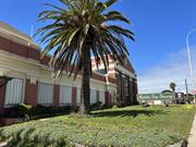
Ford Motor Co Factory (fmr) is rare as the only extant purpose-built automotive assembly plant in Western Australia remaining from the two constructed. Constructed for Ford Motor Company of Australia, the place demonstrates the local application of innovative international industrial designs which were standardised across Ford factories in Australia and overseas but rare in Western Australia, such as the scale of steel framed glass windows on the southern façade.
Ford Motor Co Factory (fmr) has considerable landmark value with an imposing physical presence on a prominent site on Stirling Highway, relating to both former industrial uses as a motor vehicle assembly plant and brewery. The siting and design were intended to establish the building as a landmark.
Ford Motor Co Factory (fmr) has historic value in its original and longstanding use as a Ford vehicle assembly plant from 1930 to 1987, a key business activity in the State’s local manufacturing industry and significant employer in Western Australia. Local materials were used as far as possible in the building’s construction.
Ford Motor Co Factory (fmr) has historic value through its association with the development of the microbrewery by Matilda Bay Brewing Company, who pioneered the disruption to the beer industry with the introduction of microbreweries. The adaptive reuse of an industrial building to a microbrewery has since been widely replicated.
Ford Motor Co Factory (fmr) has historic value in its association with the Federal Government’s post-war migration scheme which saw new migrants employed in a variety of jobs in the post-war boom. The assembly plant was also reportedly requisitioned to supply military equipment during World War Two.
Ford Motor Co Factory (fmr) is an uncommon example of a predominantly intact large-scale purpose-built industrial building in the Inter-War Functionalist style with simple geometric shapes, asymmetrical massing and large areas of steel framed glass windows.
The building is an important element in the industrial landscape of North Fremantle, which demonstrates industrial practices in the area both past and present, and is a remaining example of an industrial past which examples of this scale are uncommon.
Ford Motor Co Factory (fmr), the remnant of an industrial complex in North Fremantle, which was a former Ford Motor Company automotive assembly plant from 1930 to 1987, originally designed by Oldham Boas Ednie-Brown in the Inter-War Functionalist style consistent with national and international Ford assembly plant designs. The assembly plant was converted to use as a brewery for Matilda Bay Brewing Company in 1989 with further modifications and additions to the site. Elements that contribute to the significance of the place include (but are not limited to): • the original form of the building, comprising the administration wing, southern warehouse and saw tooth roof factory (1930; extended 1947; factory partially demolished 2011), which while reflecting innovative factory design elements applied by Ford to other plants in Australia and internationally, were rare in Western Australia; • the prominence of the building in the streetscape. Intentionally designed as a landmark in the locality, the imposing scale and massing of the building is accentuated by open landscaping and its elevated position enables uninterrupted views to the place, including to ocean-going traffic accessing Fremantle Harbour; • extant internal elements which demonstrate the place’s original use as a vehicle assembly plant, in particular the overhead crane tracks and rail line in the southern warehouse, and interior features of the administration wing including the decorative ceiling and jarrah partitions and window frames; • the building’s simple geometric shapes, asymmetrical massing and use of large steel framed windows which make it a good example of the Inter-War Functionalist style, with a classical balance between the horizontal banding and vertical brick pilasters of the warehouse frontage and the horizontal elements of the administration wing; • key extant elements which clearly demonstrate the place’s use as a brewery, notably the brew chambers and company signage, which contribute to its landmark value, and the boardroom bar. Other elements related to the brewery, such as the Administration Building (1995) are of secondary significance to the place. Internal factory machinery relating to the place’s use as an assembly plant, and auxiliary structures such as the fitters and electricians workshops, are no longer extant.
Ford Motor Co Factory (fmr) is a remnant of an industrial complex consisting of a single storey brick and iron administrative wing attached to a steel and timber framed factory space clad with corrugated iron and glass (1930; factory spaces extended 1947 and partially demolished 2011). The roof is predominantly a south facing, saw tooth construction adjoining a gabled roof structure on the southern side. To the north of the building is a small two-storey steel framed administration building clad with corrugated zincalume (1995). The buildings are located within a site that is predominantly paved with some landscaping on the front verge facing Stirling Highway.
Ford Motor Co Factory (fmr) comprises the remnant of an industrial complex consisting of a single storey brick and iron office wing attached to a steel and timber framed and saw tooth roofed open factory space clad with corrugated iron and glass, and a large double height factory space (1930; factory spaces extended 1947; saw tooth factory partially demolished 2011). Local architects, Oldham Boas Ednie-Brown, designed the original buildings in 1930 in the Inter-War Functionalist style for the Ford Motor Company Australia, with a design consistent with the company’s interstate plants and influenced by American architect Albert Kahn, who had designed factories for Ford Motor Company in the United States. The place underwent major additions and modifications in 1989 to accommodate a brewery. The site also includes an administration building (1995) to the north of the factory. In 1925 Ford Motor Company originally leased a warehouse on the western side of the railway line at Leighton from Westralian Farmers Ltd. Ford Motor vehicles were assembled at the Leighton location, now North Fremantle, from imported parts railed to the plant from Fremantle port. Vehicles were then taken by rail for distribution around the state. Ford Motor Co Factory (fmr) comprises part of the original Lot 220 in North Fremantle, which was purchased by Ford Motor Company of Australia in February 1929. The five-acre site was an irregular shaped parcel of vacant Crown land with street frontage on Victoria Avenue (now Stirling Highway), Coventry Parade and McCabe Street. The purchase was formalised in May 1929. Prominent local architects Oldham Boas and Ednie Brown were engaged to design the building. The firm Todd Bros prepared the site for £1325, and the factory was constructed by firm Finlay and Stoneman. Construction of the Ford Factory progressed throughout 1929 and the factory was completed in May 1930 at a cost of £30,300. The design of the Ford Motor Co Factory (fmr) is intentionally consistent with other Australian Ford Factories, and bears a strong resemblance to overseas plants including the Ford Motor Company Assembly Plant in Richmond, California, constructed in 1930. Upon opening in 1930, Ford’s North Fremantle plant was to be used for the assembly of motor car chassis imported in parts, building car bodies, and associated work. During the 1930s, the assembly plant produced cars and the Fordson tractor. The car chassis were shipped from Canada, and the bodies were made almost entirely of Australian materials at the Ford factory in Geelong, Victoria. The factory’s moving assembly line started in the large volume southern warehouse, where packing cases of parts were brought into the building by the railway line spur, before snaking through the saw tooth roof factory. An overhead travelling crane in the southern warehouse lifted the crates of parts to the required position and was also used to invert the chassis for installation of the Canadian-manufactured engine, clutch and transmission. n 1988, the property was transferred to H.L.H. Holdings, who initially intended to convert the place into a retail and residential development. This development did not go ahead, and instead H.L.H. Holdings entered into a lease agreement with the Matilda Bay Brewing Company. The Matilda Bay Brewing Company sought to expand their production of locally made beers previously undertaken in premises in Nedlands, and undertook a major construction programme to convert the buildings for its new function as a brewery. The Matilda Bay Brewing Company was established by Phillip Sexton and Garry Gosatti in 1984 as Brewtech, with the aim to produce traditionally brewed beers using natural ingredients in a range of styles inspired by European models. At that time all pubs in Western Australia were owned by the big breweries and only sold their proprietary beers. Brewtech originally purchased the Freemasons Hotel in Fremantle in 1984 and established a mini brewery on site, with the renamed Sail and Anchor Australia’s first pub-brewery. It was an instant success particularly as it coincided with the America’s Cup celebrations in Fremantle. The firm went on to achieve major success, acquiring new hotels and increasing the volume of products as well as the range of beers but always with an emphasis on quality. The company developed the concept of ‘retail brewing’ which directly controlled the hotels in which its beer is sold. From 1985, the company successfully expanded into other Australian states. In 1988, Brewtech changed its name to the Matilda Bay Brewery Company and was listed on the Australian Stock Exchange. In its conversion to a brewery, the building was gutted of any evidence of the former use as the Ford assembly plant. Construction work included the installation of ‘25 storage tanks, three brewing kettles each designed to hold a different brews and a giant refrigerator where the beer will continue to ferment after being bottled’. Three kettles were built into a new mezzanine floor that was constructed under the main gable closest to the front elevation. It is likely that the cool rooms were located in the rooms that were formerly used for training of mechanics on the northern side of the factory space. The new premises were opened by William McKenzie, Chairman of the State Planning Commission on 10 August 1989. In April 1990, the locally owned Matilda Bay Brewery was bought by the beverage company Carlton United Breweries (CUB) which subsequently became part of the Fosters Group. The brewery retained its name and continued to brew the original beers associated with Matilda Bay Brewery as well as CUB brand beers. In 2001, the production facilities at the Matilda Bay Brewery were increased with expenditure of $2 million to increase production by 20%, and the brewery produced 25% more beer than the previous year. In 2007, Fosters announced that production would cease at the Matilda Bay Brewing Company site, with the loss of 70 jobs, with the decision to move all brewing to the eastern states. By 2008 the plant equipment had been removed for use at other Fosters Group breweries in the eastern states, although the distinctive brass brewing kettles were left in situ with the intent of being a feature of future site development. The 100 sales and marketing staff initially continued to occupy the office spaces, and in 2011 approximately two thirds of the saw tooth roof factory bays were demolished and replaced with car parking space, modifying the building’s roughly square footprint to an L-shape. In 2014, the property was transferred to the current owners, 3 Oceans Property Pty Ltd, who plan to develop the site for residential and mixed use. The site has continued to be occupied by various leaseholders, and at 2023 the office space is occupied by 3 Oceans Property Pty Ltd, with the factory and warehouse space used for short-term leases.
Moderate
Good
| Name | Type | Year From | Year To |
|---|---|---|---|
| Oldham Boas Ednie-Brown | Architect | - | - |
| Library Id | Title | Medium | Year Of Publication |
|---|
Individual Building or Group
| Epoch | General | Specific |
|---|---|---|
| Other Use | INDUSTRIAL\MANUFACTURING | Brewery |
| Original Use | INDUSTRIAL\MANUFACTURING | Other |
| Original Use | INDUSTRIAL\MANUFACTURING | Office or Administration Bldg |
| Present Use | INDUSTRIAL\MANUFACTURING | Office or Administration Bldg |
| Style |
|---|
| Inter-War Functionalist |
| Type | General | Specific |
|---|---|---|
| Wall | GLASS | Glass |
| Wall | BRICK | Other Brick |
| Roof | TILE | Other Tile |
| Wall | METAL | Steel |
| General | Specific |
|---|---|
| TRANSPORT & COMMUNICATIONS | Road transport |
| SOCIAL & CIVIC ACTIVITIES | Sport, recreation & entertainment |
This information is provided voluntarily as a public service. The information provided is made available in good faith and is derived from sources believed to be reliable and accurate. However, the information is provided solely on the basis that readers will be responsible for making their own assessment of the matters discussed herein and are advised to verify all relevant representations, statements and information.
Constructed from 1929
22385 North Fremantle Precinct
The Former Ford Motor Company Factory, is a rendered brick large volume factory with single storey office area attached constructed in 1929. The place has aesthetic value for its contribution to the streetscape and strong landmark qualities. The place is a fine example of the Inter War Stripped Classical style of architecture. The place has historic and social significance as a long standing place of employment in the North Fremantle area. It was one of a number of standard factories developed throughout Australia and elsewhere in the 1920s as car ownership became more popular and affordable and was one of the very few if not the only car manufacturers in Western Australia.
Large volume factory with single storey office area attached. The former Ford Factory building is constructed of rendered masonry with large expanses of small pane windows. The factory frontage is dominant on the Stirling Highway frontage. It has a large pyramidal shaped parapet wall. It presents a classical balance of horizontal banding and vertical brick pilasters former by the recessed vertical glazed panels. In contrast to the dominant factory frontage, the offices provide a horizontal counterbalance. The single storey office frontage is as for the factory frontage, symmetrical and classically proportioned. The entrance is centrally located and recessed with a flat suspended canopy over it. A mosaic tile rectangular detail located in the parapet responds to the geometric shaped detail in the gable parapet of the factory front. Although now painted over the building is red brick with stone and stucco horizontal banding. It is an example of the Inter war Stripped Classical style of architecture. An external Heritage Assessment was prepared in March 2010 by Heritage and Conservation Professionals for a DA submission to Council (DA0725/09) for partial demolition of a rear portion of the building.
The portion of Stirling Highway to the north of Queen Victoria Street was originally part of Perth Road. The area developed with mixed residential, commercial and industrial uses from the 1860s following the construction of the North Fremantle Traffic Bridge and the upgrading of Perth Road by convicts. The portion of Stirling Highway that runs between the Swan River and the junction with Queen Victoria Street was formerly called Bruce Street. It was named after Colonel Bruce, head of the Pensioner Guards. In the early days of North Fremantle’s development, the favoured residential area for settlement was slightly west of the North Fremantle oval and named ‘Brucetown’. Settlement of North Fremantle began in earnest in the late 1890s and Bruce Street was characterised by a mix of building types. On the southern side of the street between Queen Victoria Street (formerly Perth Road) and Tydeman Road (formerly Pensioner Road and then John Street), the buildings were predominantly residential. Industrial use was more common on the northern side. Stirling Bridge was constructed across the Swan River at the end of Bruce Street in 1974. As Bruce Street was now the major arterial link between the bridge and Stirling Highway, the street was widened and renamed as an extension of Stirling Highway. In recent years, new high-density residential development of the areas adjacent to the river on either side of Stirling Highway has seen a significant change in the mix of buildings in the southern section of Stirling Highway. In 2004, the street continues to have a mix of residential, retail and industrial land use. In 1929, the Ford Motor Company had a factory built in North Fremantle. The factory was built to a standard Ford design, but did include the involvement of local architects, Oldham Boas and Ednie Brown. The building’s modernist design influences place it at the forefront of factory design in Western Australia at the time. Ford in Australia was part of Ford (Canada) as tariffs were not raised against imports from other Commonwealth countries. At the time, Australia was a good market for cars, with the third highest per capita ownership behind the United States and Canada. The Fremantle site was chosen because of its proximity to Fremantle Harbour, the railway line and roads. Chassis were sent by sea from Geelong in Victoria (Ford’s largest factory in Australia) and the bodies were shipped from Canada. Later, cars were shipped ready made from Melbourne and, as cars now only required a clean and spray of paint where they had been damaged, staff numbers were reduced. According to workers, the Fremantle factory followed the Ford Motor Company principles of working to the clock and the glass front of the office allowed management to keep an eye on the workers. The factory operated until 1987 when it was sold to Alan and John McGillvary of the Mac’s food centres. They initially planned to turn the factory into shops and housing, with part of the building used as a museum. However, their plans changed and in 1988, Brewtech (Matilda Bay Brewery) submitted an application to the City of Fremantle to use the existing ex-warehouse (Ford Motors) as a brewery warehouse, office and visitors’ centre. The works involved the relocation of sales, marketing and warehousing to the site, involving the construction of cool rooms and refurbishment of the existing offices, construction of brewery plant (including new site access and refurbishment of the existing building) and construction of a visitors’ centre. Previously located in Nedlands, in 1988 Matilda Bay Brewing’s speciality beer market was one of the fastest growing in Australia. In 1996, the site was short listed in the Fremantle Awards New Development Category. The place has been identified by the Heritage Council of Western Australia as being worthy of consideration for entry in the State Register of Heritage Places (March 2004). This place was included in the 'North Fremantle Heritage Study' (1994) as a place contributing to the development and heritage of North Fremantle. It was also included in the list of heritage places in the City of Fremantle identified by the Fremantle Society (1979/80) - RED -significant for contributing to the unique character of Fremantle. An external Heritage Assessment was prepared in March 2010 by Heritage and Conservation Professionals for a DA submission to Council (DA0725/09) for partial demolition of a rear portion of the building.
High degree of integrity (original intent clear, current use compatible, high long term sustainability, restored). High degree of authenticity with much original fabric remaining. (These statements based on street survey only).
Condition assessed as good (assessed from streetscape survey only).
| Name | Type | Year From | Year To |
|---|---|---|---|
| Oldham Boas and Ednie Brown | Architect | - | - |
This information is provided voluntarily as a public service. The information provided is made available in good faith and is derived from sources believed to be reliable and accurate. However, the information is provided solely on the basis that readers will be responsible for making their own assessment of the matters discussed herein and are advised to verify all relevant representations, statements and information.
social significance: demonstration of a way of life, custom, process or function. The factory processes both a vehicle manufacturer and a brewery demonstrate the working lives and conditions of people involved in those industries. Historical significance of development of cultural phases; association with important figures. The place was built in the centenary year of Western Australia demonstrating the significance of that industry to this state. The history of vehicle manufacturing technology and the mass production processes within the place are significant. The associations with the Ford Motor company. The development of a Brewing facility in 1989 is significant in the state's development. The association with Oldham Boas and Ednie-Brown architects is significant. Aesthetic ^environmental importance; townscape or land scale value; high degree of unity of setting. *architectural/technical! accomplishment The aesthetic of modem factory architecture is significant in terms of contemporaneous development in Western Australia. The degree of unity of design throughout the complex, and the streetscape value is demonstrated by the frontage onto Stirling Highway. The landmark quality of the place in terms of an unrestricted vista to and from the Indian Ocean. Rarity and Representativeness 'scarcity value; a particularly fine (or unique) example. The place is a fine example of modern factory design of the Gropius influence of which it is a unique representation in Western Australia.
The factory is situated on the narrowest point of land between the Swan River and the Indian Ocean, and commands sweeping views in all directions. The factory demonstrates modernist design influences that place it at the forefront of factory design in Western Australia at the time. The Fagus factory in Germany, designed by Walter Gropius in 1911-13, introduced curtain glass walling. Those ideas were later refined in the Bauhaus building in Dessau where the whole complex illustrated a mature modern style which subsequently became the International modern style. The use of glass without apparent structural support, gave a lightness to the building, while the light and undecorated building gave the building a clean functional image. The Ford factory shows the influences of Gropius's designs and philosophies. The huge expanses of glass on the front(west) and south elevations contrasts with the necessity for the structure that supports the glazing. The factory frontage is dominant on the Stirling Highway frontage. it presents a classical balance of horizontal banding and vertical brick pilasters formed by the recessed vertical glazed panels. In contrast to the dominant factory frontage, the offices provide a horizontal counterbalance. The one storey office frontage is as for the factory frontage, symmetrical and classically proportioned. The entrance is centrally located and recessed with a flat suspended canopy over it, but otherwise understated. A mosaic tile rectangular detail located in the parapet responds to a geometric shaped detail in the gable parapet of the factory front. The entire Stirling Highway frontage was predominantly red brick with stone block horizontal banding, and cream coloured stucco and art deco detailing. The exterior of the building is now painted in tones respectful to the original intent, having been painted entirely cream in the intervening years.
Assessment 1995 Construction 1929 The Ford Motor Company built the factory, offices and associated structures on the 7.5 hectare site in 1929. There is some significance in the fact that this was the centenary year of the settlement of Western Australia. The location of the factory in close proximity to the Great Southern Roller Mill, and on the narrow portion of land gaining close proximity to the river, the port of Fremantle, and the railway line were obviously factors advantageous to the operation of the factory. The factory operated on the site for almost 60 years, until it was sold in 1987. In 1987 Alan and John McGilfivray1 of Mac's Food Centres purchased the 7.5 acre site for about $5 million. The McGillivray's purchased the property with the view to converting it into shops and residential with part of the place being a museum. Although the land was zoned for industrial uses, the Fremantle City council had indicated that rezoning was a possibility. In 1988, Brewtech announced plans to relocate its proposed brewing plant. The plans involved a $17 million redevelopment of the Ford site, which had recently been purchased by the McGillivray brothers. A 25 year lease on the site was negotiated, and it was planned to renovate the art deco facade and encourage tourists to view the brewing process. The Matilda Bay Brewery is the number one specialty beer brewing company in Australia, brewing the brands of "Redback" and "Dogbolter", amongst others. The modem factory was designed by Oldham Boas and Ednie-Brown who later designed the Emu Brewery (now demolished) in Mounts Bay Road in Perth. It is an interesting connection that this factory which was purpose built for vehicle manufacturing, is now a Brewery, and the brewery purpose designed by the same architects is now gone. Architect: Oldham Boas & Ednie Brown
This information is provided voluntarily as a public service. The information provided is made available in good faith and is derived from sources believed to be reliable and accurate. However, the information is provided solely on the basis that readers will be responsible for making their own assessment of the matters discussed herein and are advised to verify all relevant representations, statements and information.
135 Stirling Hwy North Fremantle
Fremantle
Metropolitan
| Type | Status | Date | Documents |
|---|---|---|---|
| Heritage List | YES | 08 Mar 2007 |
| Type | Status | Date | Documents |
|---|---|---|---|
| (no listings) |
| Type | Status | Date | Grading/Management | |
|---|---|---|---|---|
| Category | ||||
| Municipal Inventory | Adopted | 18 Sep 2000 | Level 3 | |
Individual Building or Group
| Epoch | General | Specific |
|---|---|---|
| Original Use | COMMERCIAL | Other |
| Type | General | Specific |
|---|---|---|
| Wall | BRICK | Rendered Brick |
| Roof | METAL | Corrugated Iron |
| General | Specific |
|---|---|
| DEMOGRAPHIC SETTLEMENT & MOBILITY | Land allocation & subdivision |
| OCCUPATIONS | Commercial & service industries |
This information is provided voluntarily as a public service. The information provided is made available in good faith and is derived from sources believed to be reliable and accurate. However, the information is provided solely on the basis that readers will be responsible for making their own assessment of the matters discussed herein and are advised to verify all relevant representations, statements and information.
Constructed from 1921, Constructed from 1900
22385 North Fremantle Precinct
Commercial Building, 135 Stirling Highway, is a rendered masonry and iron single storey former shop dating from the 1900s. The place has aesthetic value for its contribution to the streetscape and the surrounding area. It is representative of the typical commercial building stock located within the commercial areas of North Fremantle. Historically significant as a representation of commercial buildings in the North Fremantle area.
Commercial Building, 135 Stirling Highway, is a single storey rendered masonry and iron house and shop with asymmetrical facade constructed in the Federation period. Walls are rendered masonry. Roof is hipped corrugated iron with no eaves. Front elevation is asymmetrical with a shop front window and front door. There is a portion of the building recessed further back. The shop front is set close to the front boundary. A rendered corbelled chimney remains intact.
The portion of Stirling Highway to the north of Queen Victoria Street was originally part of Perth Road. The area developed with mixed residential, commercial and industrial uses from the 1860s following the construction of the North Fremantle Traffic Bridge and the upgrading of Perth Road by convicts. The portion of Stirling Highway that runs between the Swan River and the junction with Queen Victoria Street was formerly called Bruce Street. It was named after Colonel Bruce, head of the Pensioner Guards. In the early days of North Fremantle’s development, the favoured residential area for settlement was slightly west of the North Fremantle oval and named ‘Brucetown’. Settlement of North Fremantle began in earnest in the late 1890s and Bruce Street was characterised by a mix of building types. On the southern side of the street between Queen Victoria Street (formerly Perth Road) and Tydeman Road (formerly Pensioner Road and then John Street), the buildings were predominantly residential. Industrial use was more common on the northern side. Stirling Bridge was constructed across the Swan River at the end of Bruce Street in 1974. As Bruce Street was now the major arterial link between the bridge and Stirling Highway, the street was widened and renamed as an extension of Stirling Highway. In recent years, new high-density residential development of the areas adjacent to the river on either side of Stirling Highway has seen a significant change in the mix of buildings in the southern section of Stirling Highway. In 2004, the street continues to have a mix of residential, retail and industrial land use. Commercial Building, 135 Stirling Highway was constructed at some time between c. 1900 and 1921. In 1921, the shop and rooms were owned and occupied by William Mooney, who retained ownership until his death c. 1934. Mrs Mary Smith subsequently took over the shop for her mixed business. Mrs Smith continued to occupy the place until the early 1940s, after which it had a succession of owners. Rate records indicate that improvements were made in 1957/58. A 1939 diagram shows the building as a combined shop and residence, with the shop front sitting right on the boundary, with the residence to the south and west. This place was included in the 'North Fremantle Heritage Study' (1994) as a place contributing to the development and heritage of North Fremantle. It was also included in the list of heritage places in the City of Fremantle identified by the Fremantle Society (1979/80) - BROWN -significant for making a positive contribution to the built environment of Fremantle.
Medium degree of integrity (original intent clear, current use compatible, high long term sustainability, some later unsympathetic materials). Medium degree of authenticity with some loss of original fabric. (These statements based on street survey only).
Condition assessed as fair to good (assessed from streetscape survey only).
This information is provided voluntarily as a public service. The information provided is made available in good faith and is derived from sources believed to be reliable and accurate. However, the information is provided solely on the basis that readers will be responsible for making their own assessment of the matters discussed herein and are advised to verify all relevant representations, statements and information.
137 Stirling Hwy North Fremantle
Fremantle
Metropolitan
| Type | Status | Date | Documents |
|---|---|---|---|
| (no listings) |
| Type | Status | Date | Documents |
|---|---|---|---|
| RHP - Assessed - Below Threshold | Current | 26 Nov 1999 |
| Type | Status | Date | Grading/Management | |
|---|---|---|---|---|
| Category | ||||
| (no listings) | ||||
Individual Building or Group
| Epoch | General | Specific |
|---|---|---|
| RESIDENTIAL | Single storey residence |
| Style |
|---|
| Inter-War California Bungalow |
This information is provided voluntarily as a public service. The information provided is made available in good faith and is derived from sources believed to be reliable and accurate. However, the information is provided solely on the basis that readers will be responsible for making their own assessment of the matters discussed herein and are advised to verify all relevant representations, statements and information.
139 Stirling Hwy North Fremantle
Fremantle
Metropolitan
| Type | Status | Date | Documents |
|---|---|---|---|
| Heritage List | YES | 08 Mar 2007 |
| Type | Status | Date | Documents |
|---|---|---|---|
| (no listings) |
| Type | Status | Date | Grading/Management | |
|---|---|---|---|---|
| Category | ||||
| Municipal Inventory | Adopted | 18 Sep 2000 | Level 3 | |
Individual Building or Group
| Epoch | General | Specific |
|---|---|---|
| Original Use | INDUSTRIAL\MANUFACTURING | Other |
| Type | General | Specific |
|---|---|---|
| Wall | STONE | Limestone |
| Roof | METAL | Corrugated Iron |
| General | Specific |
|---|---|
| DEMOGRAPHIC SETTLEMENT & MOBILITY | Land allocation & subdivision |
This information is provided voluntarily as a public service. The information provided is made available in good faith and is derived from sources believed to be reliable and accurate. However, the information is provided solely on the basis that readers will be responsible for making their own assessment of the matters discussed herein and are advised to verify all relevant representations, statements and information.
Constructed from 1900, Constructed from 1922
22385 North Fremantle Precinct
Former Woodturning Workshop, 139 Stirling Highway, is a limestone and iron single storey former workshop dating from the 1900s. The place has aesthetic value for its contribution to the streetscape and the surrounding area. It is representative of the industrial building stock located within North Fremantle. Historically significant as a representation of small scale industrial buildings in the North Fremantle area.
Single storey stone and iron workshop with asymmetrical facade constructed c1900 - 1922. Walls are low height rubble limestone. Roof is low pitched corrugated iron with no eaves. A large industrial sized timber door is flanked by two small windows with brick reveals. The front limestone wall is set on the front boundary line.
The portion of Stirling Highway to the north of Queen Victoria Street was originally part of Perth Road. The area developed with mixed residential, commercial and industrial uses from the 1860s following the construction of the North Fremantle Traffic Bridge and the upgrading of Perth Road by convicts. The portion of Stirling Highway that runs between the Swan River and the junction with Queen Victoria Street was formerly called Bruce Street. It was named after Colonel Bruce, head of the Pensioner Guards. In the early days of North Fremantle’s development, the favoured residential area for settlement was slightly west of the North Fremantle oval and named ‘Brucetown’. Settlement of North Fremantle began in earnest in the late 1890s and Bruce Street was characterised by a mix of building types. On the southern side of the street between Queen Victoria Street (formerly Perth Road) and Tydeman Road (formerly Pensioner Road and then John Street), the buildings were predominantly residential. Industrial use was more common on the northern side. Stirling Bridge was constructed across the Swan River at the end of Bruce Street in 1974. As Bruce Street was now the major arterial link between the bridge and Stirling Highway, the street was widened and renamed as an extension of Stirling Highway. In recent years, new high-density residential development of the areas adjacent to the river on either side of Stirling Highway has seen a significant change in the mix of buildings in the southern section of Stirling Highway. In 2004, the street continues to have a mix of residential, retail and industrial land use. The factory at 139 Stirling Highway was built at some time between c. 1900 and 1921, at which time John Adams (who also owned several other lots on Stirling Highway) was recorded as the owner. The place had a succession of owners following Adams' death c. 1931 and by 1935, it was owned by Millbrand Products, vinegar brewers. By the early 1940s, the place was owned and occupied by H.J. Doggett. In 1945, Doggett leased the site to Concrete Modelling Works and Gerardus Andries Scheffer. By 1961, Doggett was again listed as occupant of the factory and he remained so until at least 1982. This place was included in the 'North Fremantle Heritage Study' (1994) as a place contributing to the development and heritage of North Fremantle. It was also included in the list of heritage places in the City of Fremantle identified by the Fremantle Society (1979/80) - RED -significant for contributing to the unique character of Fremantle.
Medium degree of integrity (original intent clear, current use compatible, high long term sustainability, some later unsympathetic materials). Medium degree of authenticity with some loss of original fabric. (These statements based on street survey only).
Condition assessed as fair (assessed from streetscape survey only).
This information is provided voluntarily as a public service. The information provided is made available in good faith and is derived from sources believed to be reliable and accurate. However, the information is provided solely on the basis that readers will be responsible for making their own assessment of the matters discussed herein and are advised to verify all relevant representations, statements and information.
15 Stirling Hwy North Fremantle
Fremantle
Metropolitan
| Type | Status | Date | Documents |
|---|---|---|---|
| Heritage List | YES | 08 Mar 2007 |
| Type | Status | Date | Documents |
|---|---|---|---|
| (no listings) |
| Type | Status | Date | Grading/Management | |
|---|---|---|---|---|
| Category | ||||
| Municipal Inventory | Adopted | 18 Sep 2000 | Level 3 | |
Individual Building or Group
| Epoch | General | Specific |
|---|---|---|
| Present Use | RESIDENTIAL | Single storey residence |
| Original Use | RESIDENTIAL | Single storey residence |
| Style |
|---|
| Victorian Georgian |
| Type | General | Specific |
|---|---|---|
| Wall | STONE | Limestone |
| Wall | BRICK | Pointed Brick |
| Roof | METAL | Corrugated Iron |
| General | Specific |
|---|---|
| DEMOGRAPHIC SETTLEMENT & MOBILITY | Land allocation & subdivision |
This information is provided voluntarily as a public service. The information provided is made available in good faith and is derived from sources believed to be reliable and accurate. However, the information is provided solely on the basis that readers will be responsible for making their own assessment of the matters discussed herein and are advised to verify all relevant representations, statements and information.
Constructed from 1913, Constructed from 1897
22385 North Fremantle Precinct
House, 15 Stirling Highway, is a typical stone and iron single storey cottage dating from the 1890s. The place has aesthetic value for its contribution to the streetscape and the surrounding area. It is representative of the typical building stock located within the residential areas of North Fremantle. Historically significant as a representation of typical workers' houses in the North Fremantle area. The place is a simple example of the Victorian Georgian style of architecture.
House, 15 Stirling Highway, is a single storey stone and iron cottage with two storey addition to the rear designed as a late example of the Victorian sympathetically. Walls are limestone with tuckpointed brick quoins and reveals. Roof is hipped corrugated iron with no eaves. Verandah is under separate bullnose corrugated iron roof. Verandah is supported by timber posts. Front Georgian style of architecture. The place has been restored and extended elevation is symmetrical with two timber sash windows and a central front door.
The portion of Stirling Highway to the north of Queen Victoria Street was originally part of Perth Road. The area developed with mixed residential, commercial and industrial uses from the 1860s following the construction of the North Fremantle Traffic Bridge and the upgrading of Perth Road by convicts. The portion of Stirling Highway that runs between the Swan River and the junction with Queen Victoria Street was formerly called Bruce Street. It was named after Colonel Bruce, head of the Pensioner Guards. In the early days of North Fremantle’s development, the favoured residential area for settlement was slightly west of the North Fremantle oval and named ‘Brucetown’. Settlement of North Fremantle began in earnest in the late 1890s and Bruce Street was characterised by a mix of building types. On the southern side of the street between Queen Victoria Street (formerly Perth Road) and Tydeman Road (formerly Pensioner Road and then John Street), the buildings were predominantly residential. Industrial use was more common on the northern side. Stirling Bridge was constructed across the Swan River at the end of Bruce Street in 1974. As Bruce Street was now the major arterial link between the bridge and Stirling Highway, the street was widened and renamed as an extension of Stirling Highway. In recent years, new high-density residential development of the areas adjacent to the river on either side of Stirling Highway has seen a significant change in the mix of buildings in the southern section of Stirling Highway. In 2004, the street continues to have a mix of residential, retail and industrial land use. The stone, brick and iron cottage at 15 Stirling Highway (formerly 10 Bruce Street) was built between 1897 and 1913 for an unidentified owner. It was part of a larger landholding owned by Mrs Andrew Burns in 1895 and subdivided circa 1896. Between 1921 and 1929, the property was described as a four-roomed stone dwelling owned and occupied by Arthur Walter, a labourer. Between 1930 and 1935, Walter leased the cottage to a variety of tenants. Information is unavailable for the period 1936 to 1954. From 1955 to 1976, the property was owned and occupied by William Bearsby. On his death in 1976 the property was transferred to Mary Ursula Bearsby. Mary Bearsby lived at the property until ill health forced her to move to a nursing home. The property was vacant for several years and was subject to vandalism by squatters. In 1995, a demolition order was requested on behalf of the owner but the order did not proceed. The City of Fremantle undertook an assessment of the cultural heritage significance of the place and concluded that the place had heritage significance. In 1940, the place had front and rear verandahs and a galvanised iron wash house and water closet on the rear of the block. The form was similar to that shown on a 1913 plan of the place. In 1979, the front verandah was enclosed with a fibro wall with louvers inserted. Prior to 2002 extensive renovations were commenced. These included a two-storey addition to the rear of the cottage and a limestone block screen wall. Postal Directories and rate records list the following occupiers/owners over the years: * Nigel Fruin (driver) - 1931 Electoral Roll * Lionel Richardson (bootmaker) 1934 Electoral Roll * Albert Moncrieff (cabinett Maker) 1940 Electoral Roll * Mary Ursula and William John Bearsby (railway guard) - 1965 electoral Roll. This place was included in the 'North Fremantle Heritage Study' (1994) as a place contributing to the development and heritage of North Fremantle. It was also included in the list of heritage places in the City of Fremantle identified by the Fremantle Society (1979/80) - RED -significant for contributing to the unique character of Fremantle.
Moderate degree of integrity (original intent clear, current use compatible, high long term sustainability, partially restored, some loss of fabric and substantial sympathetic additions). High degree of authenticity with much original fabric remaining. (These statements based on street survey only).
Condition assessed as good (assessed from streetscape survey only). Currently under construction (restoration and addition)
This information is provided voluntarily as a public service. The information provided is made available in good faith and is derived from sources believed to be reliable and accurate. However, the information is provided solely on the basis that readers will be responsible for making their own assessment of the matters discussed herein and are advised to verify all relevant representations, statements and information.
17 Stirling Hwy North Fremantle
Fremantle
Metropolitan
| Type | Status | Date | Documents |
|---|---|---|---|
| Heritage List | YES | 08 Mar 2007 |
| Type | Status | Date | Documents |
|---|---|---|---|
| (no listings) |
| Type | Status | Date | Grading/Management | |
|---|---|---|---|---|
| Category | ||||
| Municipal Inventory | Adopted | 18 Sep 2000 | Level 3 | |
Individual Building or Group
| Epoch | General | Specific |
|---|---|---|
| Present Use | RESIDENTIAL | Single storey residence |
| Original Use | RESIDENTIAL | Single storey residence |
| Style |
|---|
| Victorian Georgian |
| Type | General | Specific |
|---|---|---|
| Wall | STONE | Limestone |
| Roof | METAL | Corrugated Iron |
| Wall | BRICK | Face Brick |
| General | Specific |
|---|---|
| DEMOGRAPHIC SETTLEMENT & MOBILITY | Land allocation & subdivision |
This information is provided voluntarily as a public service. The information provided is made available in good faith and is derived from sources believed to be reliable and accurate. However, the information is provided solely on the basis that readers will be responsible for making their own assessment of the matters discussed herein and are advised to verify all relevant representations, statements and information.
Constructed from 1897, Constructed from 1913
22385 North Fremantle Precinct
House, 17 Stirling Highway, is a typical stone and iron single storey cottage dating from the 1890s. The place has aesthetic value for its contribution to the streetscape and the surrounding area. It is representative of the typical building stock located within the residential areas of North Fremantle. Historically significant as a representation of typical workers' houses in the North Fremantle area. The place is a simple example of the Victorian Georgian style of architecture.
House, 17 Stirling Highway, is asingle storey stone and iron cottage with symmetrical facade designed as a late example of the Victorian Georgian style of architecture. Walls are limestone with brick quoins and reveals. Roof is hipped corrugated iron with no eaves. Verandah is under separate bullnose corrugated iron roof. Verandah is supported by timber posts with decorative iron filigree brackets and frieze. Front elevation is symmetrical with two timber sash windows and a central front door.There is a high limestone wall to the front boundary.
The portion of Stirling Highway to the north of Queen Victoria Street was originally part of Perth Road. The area developed with mixed residential, commercial and industrial uses from the 1860s following the construction of the North Fremantle Traffic Bridge and the upgrading of Perth Road by convicts. The portion of Stirling Highway that runs between the Swan River and the junction with Queen Victoria Street was formerly called Bruce Street. It was named after Colonel Bruce, head of the Pensioner Guards. In the early days of North Fremantle’s development, the favoured residential area for settlement was slightly west of the North Fremantle oval and named ‘Brucetown’. Settlement of North Fremantle began in earnest in the late 1890s and Bruce Street was characterised by a mix of building types. On the southern side of the street between Queen Victoria Street (formerly Perth Road) and Tydeman Road (formerly Pensioner Road and then John Street), the buildings were predominantly residential. Industrial use was more common on the northern side. Stirling Bridge was constructed across the Swan River at the end of Bruce Street in 1974. As Bruce Street was now the major arterial link between the bridge and Stirling Highway, the street was widened and renamed as an extension of Stirling Highway. In recent years, new high-density residential development of the areas adjacent to the river on either side of Stirling Highway has seen a significant change in the mix of buildings in the southern section of Stirling Highway. In 2004, the street continues to have a mix of residential, retail and industrial land use. The stone, brick and iron cottage at 17 Stirling Highway (formerly 8 Bruce Street) was built between 1897 and 1913 for an unidentified owner. It was part of a large landholding owned by Mrs Andrew Burns in 1895 and subdivided circa 1896. In 1921, the property was described as a four roomed stone house owned and occupied by Henry Hearn. Hearn occupied the cottage until at least 1961; information is not available for subsequent years. In 1940, the cottage retained its original form with verandahs on the front and rear of the building. A water tank was located close to the house and a galvanised iron structure was located on the rear boundary. In 1979, the front façade of the building was consistent with its original style. The verandah has a bull nosed roof and a picket fence defined the front boundary. In 2004, the place is used as a residence. This place was included in the 'North Fremantle Heritage Study' (1994) as a place contributing to the development and heritage of North Fremantle. It was also included in the list of heritage places in the City of Fremantle identified by the Fremantle Society (1979/80) - RED -significant for contributing to the unique character of Fremantle.
High degree of integrity (original intent clear, current use compatible, high long term sustainability). High degree of authenticity with much original fabric remaining. (These statements based on street survey only).
Condition assessed as fair (assessed from streetscape survey only).
This information is provided voluntarily as a public service. The information provided is made available in good faith and is derived from sources believed to be reliable and accurate. However, the information is provided solely on the basis that readers will be responsible for making their own assessment of the matters discussed herein and are advised to verify all relevant representations, statements and information.
209 Stirling Hwy North Fremantle
Fremantle
Metropolitan
| Type | Status | Date | Documents |
|---|---|---|---|
| (no listings) |
| Type | Status | Date | Documents |
|---|---|---|---|
| (no listings) |
| Type | Status | Date | Grading/Management | |
|---|---|---|---|---|
| Category | ||||
| Municipal Inventory | Adopted | 14 Dec 2016 | Historical Record Only | |
Historic Site
| Epoch | General | Specific |
|---|---|---|
| Original Use | RESIDENTIAL | Single storey residence |
| Other Use | COMMERCIAL | Shop\Retail Store {single} |
| Type | General | Specific |
|---|---|---|
| Wall | TIMBER | Weatherboard |
| Wall | ASBESTOS | Fibrous Cement, flat |
| Roof | METAL | Corrugated Iron |
| General | Specific |
|---|---|
| DEMOGRAPHIC SETTLEMENT & MOBILITY | Land allocation & subdivision |
This information is provided voluntarily as a public service. The information provided is made available in good faith and is derived from sources believed to be reliable and accurate. However, the information is provided solely on the basis that readers will be responsible for making their own assessment of the matters discussed herein and are advised to verify all relevant representations, statements and information.
Constructed from 1900, Constructed from 1930
22385 North Fremantle Precinct
DEMOLISHED. Retained on MHI for historical information only.
The portion of Stirling Highway to the north of Queen Victoria Street was originally part of Perth Road. The area developed with mixed residential, commercial and industrial uses from the 1860s following the construction of the North Fremantle Traffic Bridge and the upgrading of Perth Road by convicts. The portion of Stirling Highway that runs between the Swan River and the junction with Queen Victoria Street was formerly called Bruce Street. It was named after Colonel Bruce, head of the Pensioner Guards. In the early days of North Fremantle’s development, the favoured residential area for settlement was slightly west of the North Fremantle oval and named ‘Brucetown’. Settlement of North Fremantle began in earnest in the late 1890s and Bruce Street was characterised by a mix of building types. On the southern side of the street between Queen Victoria Street (formerly Perth Road) and Tydeman Road (formerly Pensioner Road and then John Street), the buildings were predominantly residential. Industrial use was more common on the northern side. Stirling Bridge was constructed across the Swan River at the end of Bruce Street in 1974. As Bruce Street was now the major arterial link between the bridge and Stirling Highway, the street was widened and renamed as an extension of Stirling Highway. In recent years, new high-density residential development of the areas adjacent to the river on either side of Stirling Highway has seen a significant change in the mix of buildings in the southern section of Stirling Highway. In 2004, the street continues to have a mix of residential, retail and industrial land use. In 1996, the place was described as a simple gabled cottage that had been converted into a shop for antiques. The separate verandah roof was supported on timber posts, with delicate iron filigree brackets attached to some of the posts. The original chimney was intact. The front of the building had been altered so it was difficult to ascertain original fabric. The place was demolished at some time after this. This place has been included in the "North Fremantle Heritage Study", prepared by Craig Burton, for the City of Fremantle, June 1994.
This information is provided voluntarily as a public service. The information provided is made available in good faith and is derived from sources believed to be reliable and accurate. However, the information is provided solely on the basis that readers will be responsible for making their own assessment of the matters discussed herein and are advised to verify all relevant representations, statements and information.
3 Stirling Hwy North Fremantle
Fremantle
Metropolitan
| Type | Status | Date | Documents |
|---|---|---|---|
| Heritage List | YES | 08 Mar 2007 |
| Type | Status | Date | Documents |
|---|---|---|---|
| (no listings) |
| Type | Status | Date | Grading/Management | |
|---|---|---|---|---|
| Category | ||||
| Municipal Inventory | Adopted | 18 Sep 2000 | Level 3 | |
Individual Building or Group
| Epoch | General | Specific |
|---|---|---|
| Original Use | RESIDENTIAL | Other |
| Style |
|---|
| Victorian Georgian |
| Type | General | Specific |
|---|---|---|
| Roof | METAL | Corrugated Iron |
| Wall | TIMBER | Weatherboard |
| General | Specific |
|---|---|
| SOCIAL & CIVIC ACTIVITIES | Government & politics |
This information is provided voluntarily as a public service. The information provided is made available in good faith and is derived from sources believed to be reliable and accurate. However, the information is provided solely on the basis that readers will be responsible for making their own assessment of the matters discussed herein and are advised to verify all relevant representations, statements and information.
Constructed from 1913, Constructed from 1991
22385 North Fremantle Precinct
Stringfellow's House, 3 Stirling Highway, is a relocated weatherboard and iron single storey cottage dating from the 1910s. The place has aesthetic value for its contribution to the streetscape and the surrounding area. It is representative of the typical building stock located within the residential areas of North Fremantle. Historically significant as a representation of typical workers' houses in the North Fremantle area. The place is a simple example of the Victorian Georgian style of architecture.
Stringfellow's House, 3 Stirling Highway, is a single storey weatherboard and iron cottage with symmetrical facade designed as a late example of the Victorian Georgian style of architecture. The walls are timber framed clad with painted weatherboards. The roof is hipped corrugated iron with no eaves. The verandah is under a separate bullnose corrugated iron roof, supported by chamfered timber posts. The front elevation is symmetrical with two timber sash windows and a central front door which has sidelights and a fanlight. There is a timber picket fence to the front boundary. When relocated, the brick corbelled chimney was rebuilt, the interior was restored, and the kitchen and bathroom upgraded.
The portion of Stirling Highway that runs between the Swan River and the junction with Queen Victoria Street was formerly called Bruce Street. It was named after Colonel Bruce, head of the Pensioner Guards. In the early days of North Fremantle’s development, the favoured residential area for settlement was slightly west of the North Fremantle oval and named ‘Brucetown’. Settlement of North Fremantle began in earnest in the late 1890s and Bruce Street was characterised by a mix of building types. On the southern side of the street between Queen Victoria Street (formerly Perth Road) and Tydeman Road (formerly Pensioner Road and then John Street), the buildings were predominantly residential. Industrial use was more common on the northern side. Stirling Bridge was constructed across the Swan River at the end of Bruce Street in 1974. As Bruce Street now the major arterial link between the bridge and Stirling Highway, the street was widened and renamed as an extension of Stirling Highway. In recent years, new high-density residential development of the areas adjacent to the river on either side of Stirling Highway has seen a significant change in the mix of buildings in the southern section of Stirling Highway. In 2004, the street continues to have a mix of residential, retail and industrial land use. McCabe Place was formerly the north end of Thompson Road. When Ford Motor Company built a factory cutting across Thompson Road c.1927, the house at 1 McCabe Place (then 102 Thompson Road) was the only house remaining on the north side. Subsequently, permission was granted to change the remaining north end of the street to McCabe Place, after Jeanette Stringfellow at 102 Thompson Road (daughter of the original owner) who married Jock McCabe in 1956. The residence now at 3 Stirling Highway was constructed originally at 102 Thompson Road for Burnett (Ben) Stringfellow by a friend in 1913-1914. Stringfellow had moved from NSW to Western Australia in 1903. Stringfellow was a blacksmith, and a founding member of North Fremantle Methodist Church. He raised his family at the place. His first wife, Jane (nee Richards) died in 1927, leaving three daughters. Stringfellow remarried, and he and his second wife, Nora Ellen, had another daughter. The Stringfellows lived at the place until Ben’s death in 1963, and the house remained in the family until 1968. After this the cottage became used for rental accommodation and the surrounding area became more industrialised. A 1939 plan shows the house as a timber cottage with a verandah across its entire front elevation, and three free-standing outbuildings in the rear yard, one of which (closest to the house) is a laundry. In the 1970s, the owner applied to build greyhound kennels at the place, but the application was refused as being not in keeping with Council policy. An application to demolish the house in 1990 prompted the Timber House Group within the Planning Committee of the City of Fremantle to use the house as a test case for the ‘Innovative Timber Houses Recycling Project’. The project was jointly funded by the City of Fremantle and the State Government’s Homeswest and aimed to provide a solution to two problems - the increasing demolition of timber houses in Fremantle and the need to provide a variety of rental accommodation to clients of Homeswest. In 1991, a newspaper article described the relocation of the residence as the result of an arrangement between Fremantle Council and Homeswest, whereby the two organisations worked together to save the cottage, which had become surrounded by an industrial area, and relocate it to vacant Council land for use as low-income rental housing. The previously vacant site was created through amalgamation and subdivision of land owned by the City of Fremantle and the Water Authority of WA. The house was sawn in half for transport to the corner of Stirling Highway and Tydeman Road, approximately 1km away to the south, where it was to be rebuilt and restored by Homeswest. Photographs show the place at that time in poor condition. It is timber-clad with fibrous cement interior walls. Brick fireplaces remain in at least three of the four main rooms. The place has a hipped corrugated iron roof and bullnose verandah with simple timber posts. The front entrance doorway has toplights and sidelights fitted with ripple glass. The rear of the residence has two hipped-roof sections and a skillion verandah covering a rear area enclosed with weatherboards, glass louvres, and fibrous cement. The Mayor of Fremantle, John Cattalini, opened the cottage on 30 May 1991. Present at the opening was Burnett Stringfellow’s daughter and two granddaughters. In 2004, the cottage is used as a residence and managed by the Department of Housing and Works.
Moderate degree of integrity (original intent clear, current use compatible, high long term sustainability, restored relocated) Moderate degree of authenticity with original fabric remaining / relocated). (These statements based on street survey only).
Condition assessed as good (assessed from streetscape survey only).
This information is provided voluntarily as a public service. The information provided is made available in good faith and is derived from sources believed to be reliable and accurate. However, the information is provided solely on the basis that readers will be responsible for making their own assessment of the matters discussed herein and are advised to verify all relevant representations, statements and information.
5 Stirling Hwy North Fremantle
Fremantle
Metropolitan
| Type | Status | Date | Documents |
|---|---|---|---|
| Heritage List | YES | 08 Mar 2007 |
| Type | Status | Date | Documents |
|---|---|---|---|
| (no listings) |
| Type | Status | Date | Grading/Management | |
|---|---|---|---|---|
| Category | ||||
| Municipal Inventory | Adopted | 18 Sep 2000 | Level 3 | |
Individual Building or Group
| Epoch | General | Specific |
|---|---|---|
| Present Use | RESIDENTIAL | Single storey residence |
| Original Use | RESIDENTIAL | Other |
| Style |
|---|
| Victorian Georgian |
| Type | General | Specific |
|---|---|---|
| Wall | TIMBER | Weatherboard |
| Roof | METAL | Corrugated Iron |
| General | Specific |
|---|---|
| DEMOGRAPHIC SETTLEMENT & MOBILITY | Land allocation & subdivision |
This information is provided voluntarily as a public service. The information provided is made available in good faith and is derived from sources believed to be reliable and accurate. However, the information is provided solely on the basis that readers will be responsible for making their own assessment of the matters discussed herein and are advised to verify all relevant representations, statements and information.
Constructed from 1913, Constructed from 1897
22385 North Fremantle Precinct
House, 5 Stirling Highway, is a typical weatherboard and iron single storey cottage dating from the 1890s. The place has aesthetic value for its contribution to the streetscape and the surrounding area. It is representative of the typical building stock located within the residential areas of North Fremantle. Historically significant as a representation of typical workers' houses in the North Fremantle area. The place is a very late simple example of the Victorian Georgian style of architecture.
House, 5 Stirling Highway, is a single storey weatherboard and iron cottage with symmetrical facade designed as a late example of the Victorian Georgian style of architecture. Walls are timber framed clad with weatherboards. Roof is hipped corrugated iron with no eaves. Front elevation is symmetrical with two timber sash windows and a central front door, with a separate bullnose verandah over. There is a rendered brick and timber picket fence to the boundary and an open side driveway. the skillion additions are weatherboard.
The portion of Stirling Highway to the north of Queen Victoria Street was originally part of Perth Road. The area developed with mixed residential, commercial and industrial uses from the 1860s following the construction of the North Fremantle Traffic Bridge and the upgrading of Perth Road by convicts. The portion of Stirling Highway that runs between the Swan River and the junction with Queen Victoria Street was formerly called Bruce Street. It was named after Colonel Bruce, head of the Pensioner Guards. In the early days of North Fremantle’s development, the favoured residential area for settlement was slightly west of the North Fremantle oval and named ‘Brucetown’. Settlement of North Fremantle began in earnest in the late 1890s and Bruce Street was characterised by a mix of building types. On the southern side of the street between Queen Victoria Street (formerly Perth Road) and Tydeman Road (formerly Pensioner Road and then John Street), the buildings were predominantly residential. Industrial use was more common on the northern side. Stirling Bridge was constructed across the Swan River at the end of Bruce Street in 1974. As Bruce Street was now the major arterial link between the bridge and Stirling Highway, the street was widened and renamed as an extension of Stirling Highway. In recent years, new high-density residential development of the areas adjacent to the river on either side of Stirling Highway has seen a significant change in the mix of buildings in the southern section of Stirling Highway. In 2004, the street continues to have a mix of residential, retail and industrial land use. The cottage at 5 Stirling Highway (formerly 22 Bruce Street) was built between 1897 and 1913 for an unidentified owner. It was originally part of North Fremantle Lot 18, which in 1890 was owned by Godfrey G Knight. The block was not built on in 1897, but a house is shown on a 1913 plan of the area. In 1925, the cottage owned by Frank Biddles was described as a weatherboard house. The cottage was leased out to tenants. Between 1930 and 1935 the property was owned by Kathleen Mary Alcock and leased to Richard Baries. In 1930, the cottage was described as a two roomed weatherboard house and in 1932 as a two roomed iron house. By 1935, another room had been added. In 1940, the long narrow galvanised iron house had a small weatherboard addition on the rear. Several small structures were located in the back yard and to the sides of the building. Little information is available on the ownership and condition of the building in the latter half of the twentieth century. A March 2016 real estate ad describes the house as boasting 3 large bedrooms (or 2 bedrooms and a separate lounge room), renovated kitchen/meals/family area and a renovated bathroom. Photographs show a new bullnose verandah with chamfered timber posts and a timber floor. There is a single garage to the side at rear (new). Internally floors are timber. There is a central passage with one room at left with a fireplace, two rooms off to the right, and an open plan kitchen/living. The kitchen chimney with stove inside is opposing side to fireplace in the front room. Further rear additions include a study/utility room and wc. A skillion verandah roof extends across the rear of the house. This place was included in the 'North Fremantle Heritage Study' (1994) as a place contributing to the development and heritage of North Fremantle. It was also included in the list of heritage places in the City of Fremantle identified by the Fremantle Society (1979/80) - RED -significant for contributing to the unique character of Fremantle.
Moderate degree of integrity (original intent clear, current use compatible, high long term sustainability, partially restored, some loss of fabric and previous unsympathetic alterations). Moderate degree of authenticity with basic original fabric remaining. (These statements based on street survey only).
Condition assessed as fair (assessed from streetscape survey only).
This information is provided voluntarily as a public service. The information provided is made available in good faith and is derived from sources believed to be reliable and accurate. However, the information is provided solely on the basis that readers will be responsible for making their own assessment of the matters discussed herein and are advised to verify all relevant representations, statements and information.
65 Stirling Hwy North Fremantle
site of salvation army hall
Fremantle
Metropolitan
| Type | Status | Date | Documents |
|---|---|---|---|
| (no listings) |
| Type | Status | Date | Documents |
|---|---|---|---|
| (no listings) |
| Type | Status | Date | Grading/Management | |
|---|---|---|---|---|
| Category | ||||
| Municipal Inventory | Adopted | 14 Dec 2016 | Historical Record Only | |
Historic site
| Epoch | General | Specific |
|---|---|---|
| Original Use | OTHER | Other |
| Present Use | OTHER | Other |
| Other Use | OTHER | Other |
This information is provided voluntarily as a public service. The information provided is made available in good faith and is derived from sources believed to be reliable and accurate. However, the information is provided solely on the basis that readers will be responsible for making their own assessment of the matters discussed herein and are advised to verify all relevant representations, statements and information.
Constructed from 1910
22385 North Fremantle Precinct
DEMOLISHED. Retained on MHI for historical information only.
The portion of Stirling Highway to the north of Queen Victoria Street was originally part of Perth Road. The area developed with mixed residential, commercial and industrial uses from the 1860s following the construction of the North Fremantle Traffic Bridge and the upgrading of Perth Road by convicts. The portion of Stirling Highway that runs between the Swan River and the junction with Queen Victoria Street was formerly called Bruce Street. It was named after Colonel Bruce, head of the Pensioner Guards. In the early days of North Fremantle’s development, the favoured residential area for settlement was slightly west of the North Fremantle oval and named ‘Brucetown’. Settlement of North Fremantle began in earnest in the late 1890s and Bruce Street was characterised by a mix of building types. On the southern side of the street between Queen Victoria Street (formerly Perth Road) and Tydeman Road (formerly Pensioner Road and then John Street), the buildings were predominantly residential. Industrial use was more common on the northern side. Stirling Bridge was constructed across the Swan River at the end of Bruce Street in 1974. As Bruce Street was now the major arterial link between the bridge and Stirling Highway, the street was widened and renamed as an extension of Stirling Highway. In recent years, new high-density residential development of the areas adjacent to the river on either side of Stirling Highway has seen a significant change in the mix of buildings in the southern section of Stirling Highway. In 2004, the street continues to have a mix of residential, retail and industrial land use. At some stage between 1910 and 1920, the Salvation Army established a hall at 65 Stirling Highway. The hall was acquired by BP Australia Ltd in 1951 and was subsequently demolished. This place was identified in the "Heritage Report on 19th century limestone walls and steps in Fremantle" prepared by Silvana Grassadonia, for the City of Fremantle, 1986.
This information is provided voluntarily as a public service. The information provided is made available in good faith and is derived from sources believed to be reliable and accurate. However, the information is provided solely on the basis that readers will be responsible for making their own assessment of the matters discussed herein and are advised to verify all relevant representations, statements and information.
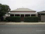
66 Stirling Hwy North Fremantle
Fremantle
Metropolitan
Constructed from 1897
| Type | Status | Date | Documents |
|---|---|---|---|
| Heritage List | YES | 08 Mar 2007 | |
| State Register | Registered | 14 Jul 2000 | HCWebsite.Listing+ListingDocument, HCWebsite.Listing+ListingDocument |
| Type | Status | Date | Documents |
|---|---|---|---|
| (no listings) |
| Type | Status | Date | Grading/Management | |
|---|---|---|---|---|
| Category | ||||
| Municipal Inventory | Adopted | 18 Sep 2000 | Level 1A | |
| Library Id | Title | Medium | Year Of Publication |
|---|---|---|---|
| 5498 | Heritage assessment of 66 Stirling Highway, North Fremantle. | Heritage Study {Other} | 1999 |
Individual Building or Group
| Epoch | General | Specific |
|---|---|---|
| Present Use | RESIDENTIAL | Single storey residence |
| Original Use | RESIDENTIAL | Two storey residence |
| Present Use | RESIDENTIAL | Two storey residence |
| Original Use | RESIDENTIAL | Single storey residence |
| Style |
|---|
| Federation Bungalow |
| Victorian Georgian |
| Type | General | Specific |
|---|---|---|
| Wall | BRICK | Pointed Brick |
| Roof | METAL | Corrugated Iron |
| Roof | METAL | Zincalume |
| Wall | BRICK | Rendered Brick |
| Wall | STONE | Limestone |
| General | Specific |
|---|---|
| DEMOGRAPHIC SETTLEMENT & MOBILITY | Land allocation & subdivision |
| DEMOGRAPHIC SETTLEMENT & MOBILITY | Workers {incl. Aboriginal, convict} |
This information is provided voluntarily as a public service. The information provided is made available in good faith and is derived from sources believed to be reliable and accurate. However, the information is provided solely on the basis that readers will be responsible for making their own assessment of the matters discussed herein and are advised to verify all relevant representations, statements and information.
Constructed from 1897
22385 North Fremantle Precinct
HCWA Register of Heritage Places-Permanent Entry House, 66 Stirling Highway has cultural heritage significance for the following reasons: (Note this information is from the HCWA Register documentation written in 2000. The place has since undergone further restoration and the external walls are no longer rendered. The tuck pointed brick has been restored and the front verandah is no longer enclosed). House, 66 Stirling Highway, a split level residence constructed with tuck pointed brick and covered in rough cast render and rendered limestone with a replacement custom orb zinc roof, has cultural heritage significance for the following reasons: the place is an unusual split level worker’s cottage; by virtue of its relationship to the lot boundaries, its scale, geometry and modest presentation, and notwithstanding its compromised state, the place contributes to the general and consistent character of this area of North Fremantle, which has a mix of built forms, including workers’ cottages, Pensioner cottages, public buildings and light industrial buildings; and, the place is part of the suburban residential development that came about with the expansion of Fremantle and South Fremantle following the discovery of gold in Western Australia in the 1880s and 1890s and the increase in population and public monies due to the goldrushes. The current render treatments, enclosure of the front verandah and gardens are considered to have low significance. The infill structures under the rear verandah and the enclosure of the rear verandah have little significance.
HCWA Register of Heritage Places-Permanent Entry House, 66 Stirling Highway (Note this information is from the HCWA Assessment documentation written in 2000. The place has since undergone further restoration and the external walls are no longer rendered. The tuck pointed brick has been restored and the front verandah is no longer enclosed. The description of the front verandah is bullnosed corrugated iron supported by timber posts with a simple timber balustrade and decorative timber brackets). "House, 66 Stirling Highway is a rectangular planned single and two storey rendered brick and stone building and basement, roofed with a corrugated iron roof, a verandah at the front (west) and an enclosed timber verandah at the rear (east). Near the southern boundary and attached to the main building is a water closet and a laundry. Further additions include a brick water closet and bathroom attached at the rear; and a timber framed shed clad in fibrous cement shed and attached to the north side of the house. The place is located in North Fremantle on the east side of Stirling Highway. Stirling Highway is a bitumen surfaced four lane highway with concrete barrier kerbs a narrow raised median, and concrete footpath. There is on landscaped verge and no parking in front of the house. Only a small strip of the original front garden remains between the house and the footpath and this is overgrown with recent plantings. House, 66 Stirling Highway is part of a group of small houses that form the built up edge of the beach-front and railway reserve at North Fremantle. On its south side is vacant land contiguous with the edge of a major green reserve. House, 66 Stirling Highway in effect forms an edge along the green space. The ground levels are relatively flat at this point, although the ground levels have accreted on the north and south and west elevations. House, 66 Stirling Highway is located on a rectangular lot. The lot is raised about 200mm above the public footpath level. The block is 12.58 metres wide along the west boundary, 24.78 metres in depth along the north boundary, 24.17 metres along the south boundary and 12.57 metres wide along the west property line. The front of the house is set back approximately 300mm from the footpath. This narrow front setback is consistent with other houses in the street and reflects the gradual encroachment of Stirling Highway. There is no side setback to the south side and only part of the north side is set back from the boundary. There is indirect access to the rear (east) garden from Hevron Street, which runs perpendicular to Stirling Highway to the south of the lot. The front garden contains a variety of unkempt grasses and shrub. There is a vegetable garden in the well-kept rear garden and chickens are kept in the side yard on the north. Access to the rear garden is through the shed on the north or through a gate in the fence that runs along the south property line. The outbuildings attached to the structures in the rear garden are a timber framed shed with fibrous cement cladding on the north property line, a plastered brick water closet. (room 14) and bathroom (room 15) on the east side of the house, and a plastered brick laundry (room 16) / water closet (room 13) on the south property line. The shed has rough stone slab paving. The other outbuildings are constructed of single leaf brick with granolithic concrete floors. The original sanitary fixtures have been replaced. The roof is a replacement zincalume roof with gutters and approximately 15 degree slope. The house is planned in four sections: a font verandah with skillion roof; a raised single storey section with unfinished basement and hipped roof; a two storey section with attic and hipped roof; a rear verandah with skillion roof. (Refer to plans, Figure 1 and 2). The west (front) elevation of the house is simply expressed in the Federation Bungalow style workers’ cottage. The west elevation (front) is on a single plane. The verandah has rendered brick piers with balustrade wall and board and lattice infill. It has a timber flush door with one glazed panel and a stained glass lead light. The verandah’s timber floor has been replaced with granolithic. The verandah roof probably reflects its original form. It has a simple lean-to roof 15 degrees of corrugated zincalume and appears to be a recent replacement. The gutters are also replacement colonial profile and are unpainted. The original timber soffit with ventilation holes in extant. The original exterior wall, west elevation, (now concealed from the street) is rough cast render over tuck-pointed brick. Invasive investigation is required to determine whether the tuck-pointed brickwork was simply a cladding to the limestone. The roof of the main house is hipped, pitched at 30 degrees, and clad with corrugated iron that is severely rusted. The gutters on the main roof are either original or early replacement gutters. The original exterior windows, west elevation (now concealed from general view) of the front elevation are double pane double hung sashes. The original front door, west elevation has been removed and replaced with a partly glazed flush door, with a single pane hopper light over it. The north and south (side) elevations are finished with render over thick limestone walls. The rear elevation comprises filled in verandahs which is either fibrous cement clad framed elements or single skin brickwork rendered elements. The windows are double pane double hung sashes in the main rooms and louvred windows to the enclosed verandahs, toilet and water closet to the rear. The front part of the house comprises Rooms 1-5, four rooms and a central corridor. Except for the sitting room (Room5), the spaces appear to be unoccupied. The original jarrah floorboards remain in place, together with 8” moulded skirtings, and wall vents. Some architraves have been replaced. Walls are painted or wall papered and plastered brick, without evidence of major cracking, except in the corners of room 3 and the south wall of room 4. The ceilings in this section of the house are lath and plaster, without cornices. Room 2, the corridor has a cast plaster ceiling rose and a semicircular arch supported on consoles. There is evidence of a painted dado and at the west end of the corridor there is a long timber batten and metal peg hat and coat rail. Except for room 1, the doors are four panel format and architraves are mostly replacement material. The ceiling and skirtings indicate evidence of chimney breasts having been removed from each of the four rooms. Room 1 contains kitchen fittings, but these are clearly of 1950s manufacture. Room 4 is fitted out with ply construction cabinetwork from the same era. Room 4 also contains an access hatch to the floor space below and this has evidently been used for storage, though there is no floor and the walls remain unfinished limestone. Room 11 has a set of steps leading through the east wall to the adjacent room which is set at a half level below it (Room 5). A half flight of steps at the east end of the hall (Room 6) leads down to the lower ground floor level where the dining room (Room 11) and kitchen (Room 12) are located. The floor in room 11 has been replaced with granolithic and the floor to room 12 remains timber. The interior of the walls are painted and plastered masonry. The ceilings are lath and plaster and room 11 has a reproduction ceiling rose in its centre. Along the west walls of both room there is a large timber plate supporting the floor above, which is in poor condition. Both rooms have wall vents, picture rails and 8” moulded timber skirtings. There is damp in the north wall and this has been covered with framed linings and decorative cabinet work. Similarly, the south wall of the kitchen is lined, probable for similar reasons. The dining room is fitted out with cabinet work, which is from the 1990s, and the kitchen with cabinets from the 1960s finished with plywood carcasses. The stairs in the hall (Room 6) are constructed in timber with turned newels and balusters and a moulded handrail. The ceilings in this area are lath and plaster at the lower level and the linings to the top level ceiling are reed moulded timber, as are the flight soffits at the lower level. The timber soffits have cove cornices. The upper and lower level doors to the stair hall are four panel format with hopper lights over them. The box room over the top of the stairs appears to have been left in its original form. Rooms 7-10 are at first floor level. Bedrooms 7 and 10 are located under the main hipped roof section of this structure. The external walls are plastered masonry and the internal walls and ceilings are lath and plaster. There is extensive crazing in room 7. Both rooms previously had fireplaces and traces of these can be seen in the walls and lath and plaster ceilings on the western walls. The skirting to room 7 is replacement bullnosed profile and the skirting to room 8 is the original moulded timber format. Both rooms open onto the original rear verandah, which has subsequently been infilled to form rooms. The eastern part of room 10 is part of the verandah and the kitchen sink in this room indicates and earlier use as a bed sitting room. The enclosed verandah comprises rooms 8, 9 and part of room 10. Room 8 is a playroom and is lined with fibrous cement sheeting. It has 3” replacement timber floors, a fibreboard skirtings, a rendered masonry west wall and fibrous cement on the north and east walls, with a ‘Beautyboard’ on the south wall. All windows are metal framed obscured glass louvres. The walls and ceilings of the bathroom and dressing room are similarly treated and the floor to the bathroom (Room 9) has been covered with fibre glass reinforced resin to make it waterproof. The fittings in this room appear to date from the 1950s and are poorly executed. The lower level rooms 13-16 are all fitted in under the verandah and have granolithic floors, rendered brick or framed walls and fibrous plaster ceilings. The bathroom in room 15 has fittings that are consistent with work that was done in the 1940s or 1050s. The bathroom in room 13 has been considerably upgraded and finishes are more recent. In September 1999 the place is occupied as a dwelling."
The portion of Stirling Highway to the north of Queen Victoria Street was originally part of Perth Road. The area developed with mixed residential, commercial and industrial uses from the 1860s following the construction of the North Fremantle Traffic Bridge and the upgrading of Perth Road by convicts. The portion of Stirling Highway to the south of Queen Victoria Street was formerly called Bruce Street and was widened and renamed following the completion of Stirling Bridge in 1974. In 2005, the highway continues to have a mix of uses. House, 66 Stirling Highway stands on Lot 12, which was purchased by Mary Anne Elizabeth Griffiths in June 1894 soon after the area was subdivided. Mary Anne sold the undeveloped property to George Alfred Davies and Fred Mason the following year, and in February 1896 ownership passed to Catherine Duggan. The house at 66 Stirling Street had been constructed by 1897, and appears on a PWD plan at this time. The house was probably built for Catherine Duggan and her husband, John. John and his brother, Thomas, ran their business, T & J Duggan Shopkeepers, from this address for a time. The Duggan family remained at 66 Stirling Highway until the early 1920s. The house had a number of owner/occupiers through the 1920s and into the 1930s. In the early 1940s, the Jeffrey family rented the place and continued to live there until 1957, despite change in ownership during this time. In 1957 the property was owned by Richard Belke, and then transferred to William and Martha Cain, who took up residence. They stayed there until 1959, after which time the house reverted to a rental property. Lionel and Annette Meiners owned 66 Stirling Highway in 1964. From 1970, the property changed hands several times, until it was acquired by Main Roads for the widening of Stirling Highway. For further information, see Heritage Council of Western Australia, ‘Register of Heritage Places: Permanent Entry – House, 66 Stirling Highway’, prepared by Kristy Bizzaca with Considine and Griffiths Architects, 2000. This place was included in the "North Fremantle Heritage Study", prepared by Craig Burton, for the City of Fremantle, June 1994 and in the list of heritage places in the City of Fremantle identified by the Fremantle Society in 1979/80.
High degree of integrity (original intent clear, current use compatible, high long term sustainability, restored). High degree of authenticity with much original fabric remaining. (These statements based on street survey only).
Condition assessed as good (assessed from streetscape survey only).
This information is provided voluntarily as a public service. The information provided is made available in good faith and is derived from sources believed to be reliable and accurate. However, the information is provided solely on the basis that readers will be responsible for making their own assessment of the matters discussed herein and are advised to verify all relevant representations, statements and information.
67 Stirling Hwy North Fremantle
Fremantle
Metropolitan
| Type | Status | Date | Documents |
|---|---|---|---|
| Heritage List | YES | 08 Mar 2007 |
| Type | Status | Date | Documents |
|---|---|---|---|
| (no listings) |
| Type | Status | Date | Grading/Management | |
|---|---|---|---|---|
| Category | ||||
| Municipal Inventory | Adopted | 18 Sep 2000 | Level 3 | |
Individual Building or Group
| Epoch | General | Specific |
|---|---|---|
| Original Use | RESIDENTIAL | Single storey residence |
| Present Use | RESIDENTIAL | Single storey residence |
| Type | General | Specific |
|---|---|---|
| Roof | METAL | Corrugated Iron |
| Wall | TIMBER | Weatherboard |
| General | Specific |
|---|---|
| DEMOGRAPHIC SETTLEMENT & MOBILITY | Land allocation & subdivision |
This information is provided voluntarily as a public service. The information provided is made available in good faith and is derived from sources believed to be reliable and accurate. However, the information is provided solely on the basis that readers will be responsible for making their own assessment of the matters discussed herein and are advised to verify all relevant representations, statements and information.
Constructed from 1945
22385 North Fremantle Precinct
House, 67 Stirling Highway, is a typical weatherboard and iron single storey cottage dating from c1945. The place has aesthetic value for its contribution to the streetscape and the surrounding area. It is representative of the typical building stock located within the residential areas of North Fremantle. Historically significant as a representation of typical workers' houses in the North Fremantle area.
House, 67 Stirling Highway, is a single storey weatherboard and iron cottage with symmetrical facade constructed in c1945. Walls are painted weatherboard. Roof is hipped corrugated iron with no eaves. Verandah is under a continuous corrugated iron roof. Windows are timber framed casements either side of a central door with side lights. There is a low level timber post and rail and mesh link fence to the front and side boundary line. The house is surrounded by commercial premises.
The portion of Stirling Highway to the north of Queen Victoria Street was originally part of Perth Road. The area developed with mixed residential, commercial and industrial uses from the 1860s following the construction of the North Fremantle Traffic Bridge and the upgrading of Perth Road by convicts. The portion of Stirling Highway that runs between the Swan River and the junction with Queen Victoria Street was formerly called Bruce Street. It was named after Colonel Bruce, head of the Pensioner Guards. In the early days of North Fremantle’s development, the favoured residential area for settlement was slightly west of the North Fremantle oval and named ‘Brucetown’. Settlement of North Fremantle began in earnest in the late 1890s and Bruce Street was characterised by a mix of building types. On the southern side of the street between Queen Victoria Street (formerly Perth Road) and Tydeman Road (formerly Pensioner Road and then John Street), the buildings were predominantly residential. Industrial use was more common on the northern side. Stirling Bridge was constructed across the Swan River at the end of Bruce Street in 1974. As Bruce Street was now the major arterial link between the bridge and Stirling Highway, the street was widened and renamed as an extension of Stirling Highway. In recent years, new high-density residential development of the areas adjacent to the river on either side of Stirling Highway has seen a significant change in the mix of buildings in the southern section of Stirling Highway. In 2004, the street continues to have a mix of residential, retail and industrial land use. House, 67 Stirling Highway was constructed c. 1945 and was the first development on the lot. In 1946, lumper Albert Ritchie was recorded as living in the house. Ritchie continued to live in the house until his death in 1966, at which time the property passed to Shirley and Robert Lock. There are no records of changes to the property on file. This place was included in the 'North Fremantle Heritage Study' (1994) as a place contributing to the development and heritage of North Fremantle. It was also included in the list of heritage places in the City of Fremantle identified by the Fremantle Society (1979/80) - YELLOW - significant for contributing to the unique character of Fremantle.
Medium degree of integrity (original intent clear, current use compatible, high long term sustainability, some later unsympathetic alterations and materials). Medium degree of authenticity with some loss of original fabric. (These statements based on street survey only).
Condition assessed as good (assessed from streetscape survey only).
This information is provided voluntarily as a public service. The information provided is made available in good faith and is derived from sources believed to be reliable and accurate. However, the information is provided solely on the basis that readers will be responsible for making their own assessment of the matters discussed herein and are advised to verify all relevant representations, statements and information.
7 Stirling Hwy North Fremantle
Fremantle
Metropolitan
| Type | Status | Date | Documents |
|---|---|---|---|
| Heritage List | YES | 08 Mar 2007 |
| Type | Status | Date | Documents |
|---|---|---|---|
| (no listings) |
| Type | Status | Date | Grading/Management | |
|---|---|---|---|---|
| Category | ||||
| Municipal Inventory | Adopted | 18 Sep 2000 | Level 3 | |
Individual Building or Group
| Epoch | General | Specific |
|---|---|---|
| Present Use | RESIDENTIAL | Single storey residence |
| Original Use | RESIDENTIAL | Single storey residence |
| Style |
|---|
| Victorian Georgian |
| Type | General | Specific |
|---|---|---|
| Wall | STONE | Limestone |
| Roof | METAL | Corrugated Iron |
| Wall | BRICK | Common Brick |
| General | Specific |
|---|---|
| DEMOGRAPHIC SETTLEMENT & MOBILITY | Land allocation & subdivision |
This information is provided voluntarily as a public service. The information provided is made available in good faith and is derived from sources believed to be reliable and accurate. However, the information is provided solely on the basis that readers will be responsible for making their own assessment of the matters discussed herein and are advised to verify all relevant representations, statements and information.
Constructed from 1913, Constructed from 1897
22385 North Fremantle Precinct
House, 7 Stirling Highway, is a typical limestone, brick and iron single storey cottage dating from the 1890s. The place has aesthetic value for its contribution to the streetscape and the surrounding area. It is representative of the typical building stock located within the residential areas of North Fremantle. Historically significant as a representation of typical workers' houses in the North Fremantle area. The place is a simple example of the Victorian Georgian style of architecture.
House, 7 Stirling Highway, is a single storey limestone, brick and iron cottage with symmetrical facade designed as a late example of the Victorian Georgian style of architecture. Walls are limestone and brick, some face and some rendered. Roof is hipped corrugated iron with no eaves. Verandah is under separate bullnose corrugated iron roof. Verandah is supported by timber posts. \side are enclosed with weatherboard. The rear skillion is weatherboard clad walls. Front elevation is symmetrical with two timber sash windows and a central front door with top and side lights. Front elevation obscured by plantings and high rendered fence to front boundary.
The portion of Stirling Highway to the north of Queen Victoria Street was originally part of Perth Road. The area developed with mixed residential, commercial and industrial uses from the 1860s following the construction of the North Fremantle Traffic Bridge and the upgrading of Perth Road by convicts. The portion of Stirling Highway that runs between the Swan River and the junction with Queen Victoria Street was formerly called Bruce Street. It was named after Colonel Bruce, head of the Pensioner Guards. In the early days of North Fremantle’s development, the favoured residential area for settlement was slightly west of the North Fremantle oval and named ‘Brucetown’. Settlement of North Fremantle began in earnest in the late 1890s and Bruce Street was characterised by a mix of building types. On the southern side of the street between Queen Victoria Street (formerly Perth Road) and Tydeman Road (formerly Pensioner Road and then John Street), the buildings were predominantly residential. Industrial use was more common on the northern side. Stirling Bridge was constructed across the Swan River at the end of Bruce Street in 1974. As Bruce Street was now the major arterial link between the bridge and Stirling Highway, the street was widened and renamed as an extension of Stirling Highway. In recent years, new high-density residential development of the areas adjacent to the river on either side of Stirling Highway has seen a significant change in the mix of buildings in the southern section of Stirling Highway. In 2004, the street continues to have a mix of residential, retail and industrial land use. The stone, brick and iron cottage at 7 Stirling Highway (formerly 18 Bruce Street) was built between 1897 and 1913 for an unidentified owner. It was part of a larger landholding owned by Mrs Andrew Burns in 1895 and subdivided circa 1896. In 1921, the property was described as a five-roomed brick house and was owned and occupied by Peter Duff. He had the cottage from 1915 but it has not been established if he was the owner for all that time. Mrs Esther Duff occupied the cottage from 1933 to 1945. From 1955 to 1980 the property was owned and occupied by Mrs Dorothy Sims. Later, Christopher D. Wall and Maxine Any McEwin owned the property jointly. In 1913, the rear of the property had a large extension across half the rear wall. By 1940, the rear of the cottage had a substantial weatherboard extension, almost doubling the size of the original cottage. All of the back boundary of the lot had structures built across it. A small verandah was located off the rear wall of the cottage and a water tank was located close to the house. The property was connected to mains sewerage system in 1952. In 1979, the front façade of the cottage had a striped iron roof on the verandah and the front boundary had a cyclone wire fence. This place was included in the 'North Fremantle Heritage Study' (1994) as a place contributing to the development and heritage of North Fremantle. It was also included in the list of heritage places in the City of Fremantle identified by the Fremantle Society (1979/80) - RED -significant for contributing to the unique character of Fremantle.
High degree of integrity (original intent clear, current use compatible, high long term sustainability, restored, sympathetic rear extension). High degree of authenticity with much original fabric remaining. (These statements based on street survey only).
Condition assessed as fair (assessed from streetscape survey only).
This information is provided voluntarily as a public service. The information provided is made available in good faith and is derived from sources believed to be reliable and accurate. However, the information is provided solely on the basis that readers will be responsible for making their own assessment of the matters discussed herein and are advised to verify all relevant representations, statements and information.
70 Stirling Hwy North Fremantle
Fremantle
Metropolitan
| Type | Status | Date | Documents |
|---|---|---|---|
| Heritage List | YES | 08 Mar 2007 |
| Type | Status | Date | Documents |
|---|---|---|---|
| (no listings) |
| Type | Status | Date | Grading/Management | |
|---|---|---|---|---|
| Category | ||||
| Municipal Inventory | Adopted | 18 Sep 2000 | Level 3 | |
Individual Building or Group
| Epoch | General | Specific |
|---|---|---|
| Present Use | RESIDENTIAL | Single storey residence |
| Original Use | RESIDENTIAL | Single storey residence |
| Style |
|---|
| Victorian Georgian |
| Type | General | Specific |
|---|---|---|
| Wall | STONE | Limestone |
| Wall | BRICK | Painted Brick |
| Roof | TILE | Terracotta Tile |
| General | Specific |
|---|---|
| DEMOGRAPHIC SETTLEMENT & MOBILITY | Land allocation & subdivision |
This information is provided voluntarily as a public service. The information provided is made available in good faith and is derived from sources believed to be reliable and accurate. However, the information is provided solely on the basis that readers will be responsible for making their own assessment of the matters discussed herein and are advised to verify all relevant representations, statements and information.
Constructed from 1900
22385 North Fremantle Precinct
House, 70 Stirling Highway, is a typical stone and iron single storey cottage dating from the 1900s. The place has aesthetic value for its contribution to the streetscape and the surrounding area. It is representative of the typical building stock located within the residential areas of North Fremantle. Historically significant as a representation of typical workers' houses in the North Fremantle area. The place is a simple example of the Victorian Georgian style of architecture.
House, 70 Stirling Highway, is a single storey stone and tile cottage with symmetrical facade designed as a late example of the Victorian Georgian style of architecture. Walls are painted limestone with painted brick quoins and reveals. Roof is hipped and tiled with no eaves. Verandah is under a separate tiled roof with metal awning attached. Verandah is supported by round metal posts with a metal balustrade. Front elevation is symmetrical with two timber sash bay windows and a central front door. There is a low level brick wall to the front boundary line.
The portion of Stirling Highway to the north of Queen Victoria Street was originally part of Perth Road. The area developed with mixed residential, commercial and industrial uses from the 1860s following the construction of the North Fremantle Traffic Bridge and the upgrading of Perth Road by convicts. The portion of Stirling Highway that runs between the Swan River and the junction with Queen Victoria Street was formerly called Bruce Street. It was named after Colonel Bruce, head of the Pensioner Guards. In the early days of North Fremantle’s development, the favoured residential area for settlement was slightly west of the North Fremantle oval and named ‘Brucetown’. Settlement of North Fremantle began in earnest in the late 1890s and Bruce Street was characterised by a mix of building types. On the southern side of the street between Queen Victoria Street (formerly Perth Road) and Tydeman Road (formerly Pensioner Road and then John Street), the buildings were predominantly residential. Industrial use was more common on the northern side. Stirling Bridge was constructed across the Swan River at the end of Bruce Street in 1974. As Bruce Street was now the major arterial link between the bridge and Stirling Highway, the street was widened and renamed as an extension of Stirling Highway. In recent years, new high-density residential development of the areas adjacent to the river on either side of Stirling Highway has seen a significant change in the mix of buildings in the southern section of Stirling Highway. In 2004, the street continues to have a mix of residential, retail and industrial land use. House, 70 Stirling Highway was built c. 1900, possibly for the Duggan family. By the early 1920s, the house was used as a rental property, before being sold to W.J. Backshall in 1925/26. Margaret Backshall is recorded as the owner of the property until at the late 1960s, although the Backshall family did not live there in the late 1930s and early 1940s. The property was subsequently purchased by Margaret Jean Dean and the Dean family continues to own the property. A 1939 diagram shows House, 70 Stirling Highway as having a full length front verandah with a centrally located front path. There was a lean-to at the rear and a path led down the eastern side of the house, across the rear and down the centre of the back yard. This place was included in the 'North Fremantle Heritage Study' (1994) as a place contributing to the development and heritage of North Fremantle. It was also included in the list of heritage places in the City of Fremantle identified by the Fremantle Society (1979/80) - BROWN -significant for making a positive contribution to the built environment of Fremantle.
Medium degree of integrity (original intent clear, current use compatible, high long term sustainability, some later unsympathetic materials). Medium degree of authenticity with some loss of original fabric. (These statements based on street survey only).
Condition assessed as fair (assessed from streetscape survey only).
This information is provided voluntarily as a public service. The information provided is made available in good faith and is derived from sources believed to be reliable and accurate. However, the information is provided solely on the basis that readers will be responsible for making their own assessment of the matters discussed herein and are advised to verify all relevant representations, statements and information.
72 Stirling Hwy North Fremantle
Fremantle
Metropolitan
| Type | Status | Date | Documents |
|---|---|---|---|
| Heritage List | YES | 08 Mar 2007 |
| Type | Status | Date | Documents |
|---|---|---|---|
| (no listings) |
| Type | Status | Date | Grading/Management | |
|---|---|---|---|---|
| Category | ||||
| Municipal Inventory | Adopted | 18 Sep 2000 | Level 3 | |
Individual Building or Group
| Epoch | General | Specific |
|---|---|---|
| Present Use | RESIDENTIAL | Single storey residence |
| Original Use | RESIDENTIAL | Single storey residence |
| Style |
|---|
| Inter-War California Bungalow |
| Type | General | Specific |
|---|---|---|
| Wall | ASBESTOS | Fibrous Cement, flat |
| Roof | TILE | Terracotta Tile |
| Wall | TIMBER | Weatherboard |
| General | Specific |
|---|---|
| DEMOGRAPHIC SETTLEMENT & MOBILITY | Land allocation & subdivision |
This information is provided voluntarily as a public service. The information provided is made available in good faith and is derived from sources believed to be reliable and accurate. However, the information is provided solely on the basis that readers will be responsible for making their own assessment of the matters discussed herein and are advised to verify all relevant representations, statements and information.
Constructed from 1934
22385 North Fremantle Precinct
House, 72 Stirling Highway, is a typical weatherboard, asbestos and iron single storey cottage dating from c1934. It is representative of the typical building stock located within the residential areas of North Fremantle. Historically significant as a representation of typical workers' houses in the North Fremantle area.
House, 72 Stirling Highway, is a single storey weatherboard, asbestos and tile cottage with asymmetrical facade constructed in 1934. Walls are painted weatherboard to dado height with asbestos sheeting above. Roof is hipped and tiled with shortened eaves. Verandah has been infilled with asbestos sheeting and aluminium framed windows. Front elevation is asymmetrical with a protruding front room. There is a timber framed window with awning above to this room. A brick chimney remains intact.
The portion of Stirling Highway to the north of Queen Victoria Street was originally part of Perth Road. The area developed with mixed residential, commercial and industrial uses from the 1860s following the construction of the North Fremantle Traffic Bridge and the upgrading of Perth Road by convicts. The portion of Stirling Highway that runs between the Swan River and the junction with Queen Victoria Street was formerly called Bruce Street. It was named after Colonel Bruce, head of the Pensioner Guards. In the early days of North Fremantle’s development, the favoured residential area for settlement was slightly west of the North Fremantle oval and named ‘Brucetown’. Settlement of North Fremantle began in earnest in the late 1890s and Bruce Street was characterised by a mix of building types. On the southern side of the street between Queen Victoria Street (formerly Perth Road) and Tydeman Road (formerly Pensioner Road and then John Street), the buildings were predominantly residential. Industrial use was more common on the northern side. Stirling Bridge was constructed across the Swan River at the end of Bruce Street in 1974. As Bruce Street was now the major arterial link between the bridge and Stirling Highway, the street was widened and renamed as an extension of Stirling Highway. In recent years, new high-density residential development of the areas adjacent to the river on either side of Stirling Highway has seen a significant change in the mix of buildings in the southern section of Stirling Highway. In 2004, the street continues to have a mix of residential, retail and industrial land use. House, 72 Stirling Highway was constructed in 1934 for Charles Percival Rule. The land had been vacant until this time. A returned serviceman, Charles Rule was a long-term councillor for North Fremantle (1948-60) and Fremantle (1961/62; 1968-73), a member of various boards and committees (including Works and Lighting and the Fremantle Cemetery), was a life member of the Fremantle Surf Club and Fremantle Bowling Club. He is locally remembered in the naming of Rule Street. The property remained in the Rule family until 1990. A 1939 diagram shows House, 72 Stirling Highway soon after it was built. It was a mall house located to the north-west of the lot, with a vineyard in the remainder of the large lot and all of the adjoining lot on White Street. The place is identified in the North Fremantle Heritage Study (1994) as being of cultural heritage significance to the development of North Fremantle. Fenced off and appears vacant as at 2016.
Medium degree of integrity (original intent clear, current use compatible, high long term sustainability, some later unsympathetic materials). Medium degree of authenticity with some loss of original fabric. (These statements based on street survey only).
Condition assessed as poor to fair (assessed from streetscape survey only).
This information is provided voluntarily as a public service. The information provided is made available in good faith and is derived from sources believed to be reliable and accurate. However, the information is provided solely on the basis that readers will be responsible for making their own assessment of the matters discussed herein and are advised to verify all relevant representations, statements and information.
76 Stirling Hwy North Fremantle
Fremantle
Metropolitan
| Type | Status | Date | Documents |
|---|---|---|---|
| Heritage List | YES | 08 Mar 2007 |
| Type | Status | Date | Documents |
|---|---|---|---|
| (no listings) |
| Type | Status | Date | Grading/Management | |
|---|---|---|---|---|
| Category | ||||
| Municipal Inventory | Adopted | 18 Sep 2000 | Level 2 | |
| Statewide Hotel Survey | Completed | 01 Nov 1997 | ||
03842 Stirling Highway Precinct
Individual Building or Group
| Epoch | General | Specific |
|---|---|---|
| Present Use | COMMERCIAL | Hotel, Tavern or Inn |
| Original Use | RESIDENTIAL | Institutional Housing |
| Style |
|---|
| Federation Free Style |
| Type | General | Specific |
|---|---|---|
| Wall | BRICK | Rendered Brick |
| Wall | BRICK | Face Brick |
| Roof | METAL | Corrugated Iron |
| Wall | RENDER | Roughcast |
| General | Specific |
|---|---|
| OCCUPATIONS | Hospitality industry & tourism |
| SOCIAL & CIVIC ACTIVITIES | Sport, recreation & entertainment |
This information is provided voluntarily as a public service. The information provided is made available in good faith and is derived from sources believed to be reliable and accurate. However, the information is provided solely on the basis that readers will be responsible for making their own assessment of the matters discussed herein and are advised to verify all relevant representations, statements and information.
Constructed from 1927
22385 North Fremantle Precinct
Rose Hotel (former), 78 Stirling Highway, is a brick and tile two storey hotel building dating from the 1927. The place has aesthetic value for its contribution to the streetscape and strong landmark qualities. The place is a late example of the Federation Free Style of architecture. The place has historic and social significance as a long standing hotel in the North Fremantle area. The hotel was one of a number built and operated by the Swan Brewery. The place has social significance as it was a popular meeting venue for the local North Fremantle community, including workers from the nearby port and related industries.
Stirling Highway is a main arterial road that extends in a north to south direction from High Street Fremantle through and past the boundary of the City’s area. The Rose Hotel (Former), 78 Stirling Highway is located on the east side of Stirling Highway between White Street and Alfred Road. The Rose Hotel (former) constructed in 1927 is a double storey brick and iron hotel with symmetrical facade designed as an example of the Federation Free style of architecture. Walls are face brick with rendered detailing to the ground floor and rough cast rendered brick with face brick detailing to the upper floor. Roof is hipped and gabled corrugated iron with exposed eaves. There is a large gable central to the front elevation. This gable is finished with roughcast render and has red face brick and timber detailing. The name ROSE HOTEL in red face brick is located on this gable end. There is a colonnaded central porch and balcony above with face brick and rendered brick piers. Windows are generally timber framed double hung sash. During 2008 the development of a three storey brick and rendered brick and Colorbond roof apartment block was completed. Some conservation to the former hotel was undertaken at this time including the reconstruction of a verandah on the northern side of the building. A Heritage Assessment was prepared in July 2010 by the City of Fremantle for a DA submission to Council for external signage.
The portion of Stirling Highway to the north of Queen Victoria Street was originally part of Perth Road. The area developed with mixed residential, commercial and industrial uses from the 1860s following the construction of the North Fremantle Traffic Bridge and the upgrading of Perth Road by convicts. The portion of Stirling Highway that runs between the Swan River and the junction with Queen Victoria Street was formerly called Bruce Street. It was named after Colonel Bruce, head of the Pensioner Guards. In the early days of North Fremantle’s development, the favoured residential area for settlement was slightly west of the North Fremantle oval and named ‘Brucetown’. Settlement of North Fremantle began in earnest in the late 1890s and Bruce Street was characterised by a mix of building types. On the southern side of the street between Queen Victoria Street (formerly Perth Road) and Tydeman Road (formerly Pensioner Road and then John Street), the buildings were predominantly residential. Industrial use was more common on the northern side. Stirling Bridge was constructed across the Swan River at the end of Bruce Street in 1974. As Bruce Street was now the major arterial link between the bridge and Stirling Highway, the street was widened and renamed as an extension of Stirling Highway. In recent years, new high-density residential development of the areas adjacent to the river on either side of Stirling Highway has seen a significant change in the mix of buildings in the southern section of Stirling Highway. In 2004, the street continues to have a mix of residential, retail and industrial land use. Rose Hotel was constructed in 1927 for the Swan Brewery. Erncot Cocks was granted the first publican’s lease, which he held until 1964 when the lease was taken over by mother and son team, Chris and Stan Omodei. The Omodeis purchased the hotel freehold in 1978. The Swan Brewery (trading as Swan Breweries) was founded in 1857 by unemployed architect, Frederick Sherwood, who successfully made malt beer from imported English barley. The business was taken over by William Mumme and John Ferguson after Sherwood died in 1874 and in 1887, the business was floated as the Swan Brewery Co. Ltd., with many of its shares purchased by Melbourne investors. The Swan Brewery purchased and built many hotels throughout Western Australia. [This Rose Hotel is sometimes confused with a hotel of the same name on John Street (originally Pensioner Road). That Rose Hotel was built c. 1888 as a cottage of three rooms, owned by Adam Oliver and occupied by a number of tenants. In 1894, Oliver was listed as the keeper of the Rose Hotel on Pensioner Road. The following year, the hotel was listed as comprising 12 rooms. The hotel was still extant in 1929 but it is not known when it was demolished.] A 1939 diagram shows the Rose Hotel as being a brick hotel of a rough ‘H’ shape, with a central front verandah between two projecting bays. A similar verandah was located to the rear. There was also a large paved area at the back of the hotel (beer garden?), and a wide path between the hotel and the car park to the north. The place is identified in the North Fremantle Heritage Study (1994) as being of cultural heritage significance to the development of North Fremantle. A Heritage Assessment was prepared in July 2010 by the City of Fremantle for a DA submission to Council for external signage.
Low degree of integrity (original intent unclear, current use compatible, high long term sustainability). Medium degree of authenticity with some original fabric remaining. (These statements based on street survey only).
Condition assessed as good (assessed from streetscape survey only).
This information is provided voluntarily as a public service. The information provided is made available in good faith and is derived from sources believed to be reliable and accurate. However, the information is provided solely on the basis that readers will be responsible for making their own assessment of the matters discussed herein and are advised to verify all relevant representations, statements and information.
79 Stirling Hwy North Fremantle
Fremantle
Metropolitan
| Type | Status | Date | Documents |
|---|---|---|---|
| Heritage List | YES | 08 Mar 2007 |
| Type | Status | Date | Documents |
|---|---|---|---|
| (no listings) |
| Type | Status | Date | Grading/Management | |
|---|---|---|---|---|
| Category | ||||
| Municipal Inventory | Adopted | 18 Sep 2000 | Level 3 | |
Individual Building or Group
| Epoch | General | Specific |
|---|---|---|
| Original Use | RESIDENTIAL | Other |
| Style |
|---|
| Victorian Georgian |
| Type | General | Specific |
|---|---|---|
| Roof | METAL | Corrugated Iron |
| Wall | STONE | Limestone |
| Wall | RENDER | Smooth |
| General | Specific |
|---|---|
| DEMOGRAPHIC SETTLEMENT & MOBILITY | Land allocation & subdivision |
This information is provided voluntarily as a public service. The information provided is made available in good faith and is derived from sources believed to be reliable and accurate. However, the information is provided solely on the basis that readers will be responsible for making their own assessment of the matters discussed herein and are advised to verify all relevant representations, statements and information.
Constructed from 1922, Constructed from 1900
22385 North Fremantle Precinct
House, 79 Stirling Highway, is a typical rendered stone and iron single storey cottage dating from the early 1900s. The place has aesthetic value for its contribution to the streetscape and the surrounding area. It is representative of the typical building stock located within the residential areas of North Fremantle. Historically significant as a representation of typical workers' houses in the North Fremantle area. The place is a simple example of the Victorian Georgian style of architecture.
House, 79 Stirling Highway, is a single storey stone and iron cottage with symmetrical facade designed as a late example of the Victorian Georgian style of architecture. Walls are rendered and painted masonry. Roof is hipped corrugated iron with no eaves. Verandah is under a separate bullnose corrugated iron roof. Verandah is supported by timber posts. Front elevation is symmetrical with two timber sash windows and a central front door. The house is well elevated above street level with a set of concrete steps leading up to verandah level. There is a later single garage at street level and on the front boundary. This garage has a balustrade deck area on the roof which is at the verandah floor height.
The portion of Stirling Highway to the north of Queen Victoria Street was originally part of Perth Road. The area developed with mixed residential, commercial and industrial uses from the 1860s following the construction of the North Fremantle Traffic Bridge and the upgrading of Perth Road by convicts. The portion of Stirling Highway that runs between the Swan River and the junction with Queen Victoria Street was formerly called Bruce Street. It was named after Colonel Bruce, head of the Pensioner Guards. In the early days of North Fremantle’s development, the favoured residential area for settlement was slightly west of the North Fremantle oval and named ‘Brucetown’. Settlement of North Fremantle began in earnest in the late 1890s and Bruce Street was characterised by a mix of building types. On the southern side of the street between Queen Victoria Street (formerly Perth Road) and Tydeman Road (formerly Pensioner Road and then John Street), the buildings were predominantly residential. Industrial use was more common on the northern side. Stirling Bridge was constructed across the Swan River at the end of Bruce Street in 1974. As Bruce Street was now the major arterial link between the bridge and Stirling Highway, the street was widened and renamed as an extension of Stirling Highway. In recent years, new high-density residential development of the areas adjacent to the river on either side of Stirling Highway has seen a significant change in the mix of buildings in the southern section of Stirling Highway. In 2004, the street continues to have a mix of residential, retail and industrial land use. House, 79 Stirling Highway was constructed at some time between c. 1900 and 1922. In 1921/22, it was recorded as being a four roomed stone cottage owned and occupied by Robert Short. Short held the title until circa 1925, when ownership passed to Robert L. Bull. It appears that Bull stayed there until the early 1940s, upon which time he sold the place to Arthur Urquhart, who held it as a rental property. Some time after 1955, Urquhart passed ownership to Michele Di Carlo. Although he did not continuously live there, Di Carlo held the title to the property until at least 1982. A 1939 diagram shows House, 79 Stirling Highway as a relatively large house, with full length front and rear verandahs. The diagram clearly shows steps leading to the front door. This place was included in the list of heritage places in the City of Fremantle identified by the Fremantle Society (1979/80) - BROWN -significant for making a positive contribution to the built environment of Fremantle.
High degree of integrity (original intent clear, current use compatible, high long term sustainability, restored). medium degree of authenticity with some loss of original fabric. (These statements based on street survey only).
Condition assessed as good (assessed from streetscape survey only).
This information is provided voluntarily as a public service. The information provided is made available in good faith and is derived from sources believed to be reliable and accurate. However, the information is provided solely on the basis that readers will be responsible for making their own assessment of the matters discussed herein and are advised to verify all relevant representations, statements and information.