Local Government
Fremantle
Region
Metropolitan
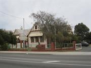
17 Staples St North Fremantle
Fremantle
Metropolitan
| Type | Status | Date | Documents |
|---|---|---|---|
| Heritage List | YES | 08 Mar 2007 |
| Type | Status | Date | Documents |
|---|---|---|---|
| (no listings) |
| Type | Status | Date | Grading/Management | |
|---|---|---|---|---|
| Category | ||||
| Municipal Inventory | Adopted | 18 Sep 2000 | Level 3 | |
Individual Building or Group
| Epoch | General | Specific |
|---|---|---|
| Original Use | RESIDENTIAL | Single storey residence |
| Present Use | RESIDENTIAL | Single storey residence |
| Style |
|---|
| Victorian Georgian |
| Type | General | Specific |
|---|---|---|
| Wall | STONE | Limestone |
| Roof | METAL | Corrugated Iron |
| Wall | BRICK | Common Brick |
| General | Specific |
|---|---|
| DEMOGRAPHIC SETTLEMENT & MOBILITY | Land allocation & subdivision |
This information is provided voluntarily as a public service. The information provided is made available in good faith and is derived from sources believed to be reliable and accurate. However, the information is provided solely on the basis that readers will be responsible for making their own assessment of the matters discussed herein and are advised to verify all relevant representations, statements and information.
Constructed from 1932
22385 North Fremantle Precinct
House, 17 Staples Street is a typical stone and iron single storey cottage dating from 1932. The place has aesthetic value for its contribution to the streetscape and the surrounding area. It is representative of the typical building stock located within the residential areas of North Fremantle. Historically significant as a representation of typical workers' houses in the North Fremantle area. The place is a late example of the Victorian Georgian style of architecture.
House, 17 Staples Street is a single storey limestone and iron cottage with symmetrical facade designed as a late example of the Victorian Georgian style of architecture. Walls are limestone with brick quoins and reveals. Roof is hipped corrugated iron with no eaves. The verandah is under a separate corrugated iron roof supported by timber posts. Front elevation is symmetrical with two timber sash windows and a central front door. There is a low limestone wall to the front boundary line. There is a side carport and the skillion addition at the rear has rendered walls.
Bounded in the west by Stirling Highway and in the east by Rule Street, Staples Street is divided by Thompson Road. The area forms part of an original land grant to the Pensioner Guards (lots P57 and P66). On 31 May 1895, Lot P66 was subdivided, while Lot P57 was not subdivided until 26 February 1897. The street was listed as Davis Street in the Post Office directories between 1898 and c. 1915, and then as Davies Road until 1962. The street name was officially changed in June 1962 in honour of Ronald John Staples who served on the North Fremantle (1940-61) and Fremantle (1961-73) councils. Staples was born in Harvest Road, North Fremantle, in 1910; attended North Fremantle Primary School and Fremantle Boy’s School and worked in clerical occupations. Staples Street was developed between 1904 and 1920, although some lots remained vacant until the 1940s. The street was predominantly working class, with many male occupants employed on the nearby waterfront, the railways or in the construction industry as sawyers or bricklayers. Buildings in the street are characterised by small, modest cottages on small lots, with building materials ranging from weatherboard and asbestos or fibro cement to brick. House, 17 Staples Street was built in 1932. The site has a considerable history of development. The site was initially occupied by two cottages built in 1880/81 and c. 1885 for pensioner guard, Thomas McLochlan. In 1885, both two roomed cottages were occupied – one by a quarryman and the other by ex-pensioner guard, Thomas McCreary, a tanner. By the late 1880s, both cottages were recorded as having four rooms. By 1921, a four roomed wooden house was recorded as being on the property. It is assumed that either one or both of the earlier cottages had been removed by this time (and perhaps a new house built). In 1921, the house was owned by the estate of John Bick and occupied by long-term tenant Alfred Bristow. By 1932, a stone house of four rooms was recorded as being on the property. The house has had a number of owners since the late 1960s. This place was included in the 'North Fremantle Heritage Study' (1994) as a place contributing to the development and heritage of North Fremantle. It was also included in the list of heritage places in the City of Fremantle identified by the Fremantle Society (1979/80) - BROWN -significant for making a positive contribution to the built environment of Fremantle.
High degree of integrity (original intent clear, current use compatible, high long term sustainability, restored). High degree of authenticity with much original fabric remaining. (These statements based on street survey only).
Condition assessed as good (assessed from streetscape survey only).
This information is provided voluntarily as a public service. The information provided is made available in good faith and is derived from sources believed to be reliable and accurate. However, the information is provided solely on the basis that readers will be responsible for making their own assessment of the matters discussed herein and are advised to verify all relevant representations, statements and information.
18 Staples St North Fremantle
Fremantle
Metropolitan
| Type | Status | Date | Documents |
|---|---|---|---|
| Heritage List | YES | 08 Mar 2007 |
| Type | Status | Date | Documents |
|---|---|---|---|
| (no listings) |
| Type | Status | Date | Grading/Management | |
|---|---|---|---|---|
| Category | ||||
| Municipal Inventory | Adopted | 18 Sep 2000 | Level 3 | |
Individual Building or Group
| Epoch | General | Specific |
|---|---|---|
| Original Use | RESIDENTIAL | Single storey residence |
| Present Use | RESIDENTIAL | Single storey residence |
| Style |
|---|
| Victorian Georgian |
| Type | General | Specific |
|---|---|---|
| Roof | METAL | Corrugated Iron |
| Wall | STONE | Limestone |
| Wall | RENDER | Smooth |
| General | Specific |
|---|---|
| DEMOGRAPHIC SETTLEMENT & MOBILITY | Land allocation & subdivision |
This information is provided voluntarily as a public service. The information provided is made available in good faith and is derived from sources believed to be reliable and accurate. However, the information is provided solely on the basis that readers will be responsible for making their own assessment of the matters discussed herein and are advised to verify all relevant representations, statements and information.
Constructed from 1917, Constructed from 1911
22385 North Fremantle Precinct
House, 18 Staples Street, is a typical stone and iron single storey cottage dating from the 1911. The place has aesthetic value for its contribution to the streetscape and the surrounding area. It is representative of the typical building stock located within the residential areas of North Fremantle. Historically significant as a representation of typical workers' houses in the North Fremantle area. The place is a late example of the Victorian Georgian style of architecture.
House, 18 Staples Street, is a single storey rendered stone and iron cottage with symmetrical facade designed as a late example of the Victorian Georgian style of architecture. Walls are painted and rendered. Roof is hipped corrugated iron with no eaves. There is no verandah roof. Front elevation is symmetrical with two timber sash windows and a central front door with top light. There is a brick and timber picket fence to the front boundary line.
Bounded in the west by Stirling Highway and in the east by Rule Street, Staples Street is divided by Thompson Road. The area forms part of an original land grant to the Pensioner Guards (lots P57 and P66). On 31 May 1895, Lot P66 was subdivided, while Lot P57 was not subdivided until 26 February 1897. The street was listed as Davis Street in the Post Office directories between 1898 and c. 1915, and then as Davies Road until 1962. The street name was officially changed in June 1962 in honour of Ronald John Staples who served on the North Fremantle (1940-61) and Fremantle (1961-73) councils. Staples was born in Harvest Road, North Fremantle, in 1910; attended North Fremantle Primary School and Fremantle Boy’s School and worked in clerical occupations. Staples Street was developed between 1904 and 1920, although some lots remained vacant until the 1940s. The street was predominantly working class, with many male occupants employed on the nearby waterfront, the railways or in the construction industry as sawyers or bricklayers. Buildings in the street are characterised by small, modest cottages on small lots, with building materials ranging from weatherboard and asbestos or fibro cement to brick. House, 18 Staples Street was built between 1911 and 1917. By 1923, the house was owned and occupied by Isabella Fettes. At this time, it was described as a timber house of four rooms. Isabella Fettes sold the property to Annie Green in 1927, when it was described as being a four roomed stone house. By the mid-1950s, the property was owned by George Jacob and has had a number of owners since Mr Jacob died in the mid-1960s. This place was included in the 'North Fremantle Heritage Study' (1994) as a place contributing to the development and heritage of North Fremantle. It was also included in the list of heritage places in the City of Fremantle identified by the Fremantle Society (1979/80) - RED -significant for contributing to the unique character of Fremantle. In 2003 the place had a verandah roof with timber posts, but as at 2016 this has been removed.
Medium degree of integrity (original intent clear, current use compatible, high long term sustainability, some later unsympathetic materials). Medium degree of authenticity with some loss of original fabric. (These statements based on street survey only).
Condition assessed as poor (assessed from streetscape survey only).
This information is provided voluntarily as a public service. The information provided is made available in good faith and is derived from sources believed to be reliable and accurate. However, the information is provided solely on the basis that readers will be responsible for making their own assessment of the matters discussed herein and are advised to verify all relevant representations, statements and information.
3 Staples St North Fremantle
Fremantle
Metropolitan
| Type | Status | Date | Documents |
|---|---|---|---|
| Heritage List | YES | 08 Mar 2007 |
| Type | Status | Date | Documents |
|---|---|---|---|
| (no listings) |
| Type | Status | Date | Grading/Management | |
|---|---|---|---|---|
| Category | ||||
| Municipal Inventory | Adopted | 18 Sep 2000 | Level 3 | |
Individual Building or Group
| Epoch | General | Specific |
|---|---|---|
| Present Use | RESIDENTIAL | Single storey residence |
| Original Use | RESIDENTIAL | Single storey residence |
| Style |
|---|
| Victorian Georgian |
| Type | General | Specific |
|---|---|---|
| Roof | METAL | Corrugated Iron |
| Wall | TIMBER | Weatherboard |
| General | Specific |
|---|---|
| DEMOGRAPHIC SETTLEMENT & MOBILITY | Land allocation & subdivision |
This information is provided voluntarily as a public service. The information provided is made available in good faith and is derived from sources believed to be reliable and accurate. However, the information is provided solely on the basis that readers will be responsible for making their own assessment of the matters discussed herein and are advised to verify all relevant representations, statements and information.
Constructed from 1910
22385 North Fremantle Precinct
House, 3 Staples Street is a typical weatherboard and iron single storey cottage dating from c1910. The place has aesthetic value for its contribution to the streetscape and the surrounding area. It is representative of the typical building stock located within the residential areas of North Fremantle. Historically significant as a representation of typical workers' houses in the North Fremantle area. The place is a late example of the Victorian Georgian style of architecture.
House, 3 Staples Street is a single storey weatherboard and iron cottage with symmetrical facade designed as a late example of the Victorian Georgian style of architecture. Walls are painted weatherboards. The roof is hipped corrugated iron with no eaves. The verandah is under a separate corrugated iron bullnose roof supported by timber posts with a simple timber balustrade and timber steps. The front elevation is symmetrical with two timber sash windows and a central front door. There is a low random course limestone wall to the front boundary.
Bounded in the west by Stirling Highway and in the east by Rule Street, Staples Street is divided by Thompson Road. The area forms part of an original land grant to the Pensioner Guards (lots P57 and P66). On 31 May 1895, Lot P66 was subdivided, while Lot P57 was not subdivided until 26 February 1897. The street was listed as Davis Street in the Post Office directories between 1898 and c. 1915, and then as Davies Road until 1962. The street name was officially changed in June 1962 in honour of Ronald John Staples who served on the North Fremantle (1940-61) and Fremantle (1961-73) councils. Staples was born in Harvest Road, North Fremantle, in 1910; attended North Fremantle Primary School and Fremantle Boy’s School and worked in clerical occupations. Staples Street was developed between 1904 and 1920, although some lots remained vacant until the 1940s. The street was predominantly working class, with many male occupants employed on the nearby waterfront, the railways or in the construction industry as sawyers or bricklayers. Buildings in the street are characterised by small, modest cottages on small lots, with building materials ranging from weatherboard and asbestos or fibro cement to brick. House, 3 Staples Street was constructed c. 1910. In 1923, it was described as being a timber house of four rooms, owned and occupied by Mary A Brown. Brown continued to own and live in the house until the mid-1930s and the house has had a number of owner occupiers since that time. A 1939 plan shows a weatherboard house with front and rear verandahs, and a weatherboard laundry and water closet at the rear of the back garden The house was extensively extended and renovated in 1993 with weatherboard and iron additions to the rear. This place was included in the 'North Fremantle Heritage Study' (1994) as a place contributing to the development and heritage of North Fremantle. It was also included in the list of heritage places in the City of Fremantle identified by the Fremantle Society (1979/80) - BROWN -significant for making a positive contribution to the built environment of Fremantle.
High degree of integrity (original intent clear, current use compatible, high long term sustainability, restored). High degree of authenticity with much original fabric remaining. (These statements based on street survey only).
Condition assessed as good (assessed from streetscape survey only).
This information is provided voluntarily as a public service. The information provided is made available in good faith and is derived from sources believed to be reliable and accurate. However, the information is provided solely on the basis that readers will be responsible for making their own assessment of the matters discussed herein and are advised to verify all relevant representations, statements and information.
4 Staples St North Fremantle
Fremantle
Metropolitan
| Type | Status | Date | Documents |
|---|---|---|---|
| Heritage List | YES | 08 Mar 2007 |
| Type | Status | Date | Documents |
|---|---|---|---|
| (no listings) |
| Type | Status | Date | Grading/Management | |
|---|---|---|---|---|
| Category | ||||
| Municipal Inventory | Adopted | 18 Sep 2000 | Level 3 | |
Individual Building or Group
| Epoch | General | Specific |
|---|---|---|
| Present Use | RESIDENTIAL | Single storey residence |
| Original Use | RESIDENTIAL | Single storey residence |
| Type | General | Specific |
|---|---|---|
| Wall | BRICK | Face Brick |
| Roof | METAL | Corrugated Iron |
| General | Specific |
|---|---|
| DEMOGRAPHIC SETTLEMENT & MOBILITY | Land allocation & subdivision |
This information is provided voluntarily as a public service. The information provided is made available in good faith and is derived from sources believed to be reliable and accurate. However, the information is provided solely on the basis that readers will be responsible for making their own assessment of the matters discussed herein and are advised to verify all relevant representations, statements and information.
Constructed from 1929, Constructed from 1928
22385 North Fremantle Precinct
House, 4 Staples Street is a typical brick and iron single storey cottage dating from 1928-1929. The place has aesthetic value for its contribution to the streetscape and the surrounding area. It is representative of the typical building stock located within the residential areas of North Fremantle. Historically significant as a representation of typical workers' houses in the North Fremantle area.
House, 4 Staples Street is a single storey brick and iron cottage with symmetrical facade constructed in 1928-1929. Walls are face brick. The roof is hipped corrugated iron with no eaves. The verandah is under a continuous corrugated iron roof supported by square timber posts. Front elevation is symmetrical with two timber sash windows with rendered sills and a central front door. The verandah is at ground level and has been tiled. There is a limestone wall to the front boundary line. There is a rear extension and alterations.
Bounded in the west by Stirling Highway and in the east by Rule Street, Staples Street is divided by Thompson Road. The area forms part of an original land grant to the Pensioner Guards (lots P57 and P66). On 31 May 1895, Lot P66 was subdivided, while Lot P57 was not subdivided until 26 February 1897. The street was listed as Davis Street in the Post Office directories between 1898 and c. 1915, and then as Davies Road until 1962. The street name was officially changed in June 1962 in honour of Ronald John Staples who served on the North Fremantle (1940-61) and Fremantle (1961-73) councils. Staples was born in Harvest Road, North Fremantle, in 1910; attended North Fremantle Primary School and Fremantle Boy’s School and worked in clerical occupations. Staples Street was developed between 1904 and 1920, although some lots remained vacant until the 1940s. The street was predominantly working class, with many male occupants employed on the nearby waterfront, the railways or in the construction industry as sawyers or bricklayers. Buildings in the street are characterised by small, modest cottages on small lots, with building materials ranging from weatherboard and asbestos or fibro cement to brick. House, 4 Staples Street was built 1928/29 for owner Edward Oldfield, a bricklayer. It replaced an earlier house on the site. The house has had a number of owner/occupiers over the years, including William Houlahan (driver), Arthur Onley (labourer) and Leslie Onley (tanner). A 1939 plan shows 4 Staples Street as being the largest house in the street, with a greater street setback than neighbouring properties. The brick house had a full length front verandah and brick outbuildings in the rear yard. A paved path led to the centrally located front door. The place was identified in the North Fremantle Heritage Study (1994) as being of cultural heritage significance to the development of North Fremantle. By 2004, extensive renovations had been completed to the house, including conversion of a well into a wine cellar, accessed through a trapdoor in the floor of the formal lounge. At this time, the house had three bedrooms, two bathrooms and a natural stone storeroom under the rear of the house.
Medium degree of integrity (original intent clear, current use compatible, high long term sustainability, some later unsympathetic materials). Medium degree of authenticity with some loss of original fabric. (These statements based on street survey only).
Condition assessed as good (assessed from streetscape survey only).
This information is provided voluntarily as a public service. The information provided is made available in good faith and is derived from sources believed to be reliable and accurate. However, the information is provided solely on the basis that readers will be responsible for making their own assessment of the matters discussed herein and are advised to verify all relevant representations, statements and information.
5 Staples St North Fremantle
Fremantle
Metropolitan
| Type | Status | Date | Documents |
|---|---|---|---|
| Heritage List | YES | 08 Mar 2007 |
| Type | Status | Date | Documents |
|---|---|---|---|
| (no listings) |
| Type | Status | Date | Grading/Management | |
|---|---|---|---|---|
| Category | ||||
| Municipal Inventory | Adopted | 18 Sep 2000 | Level 3 | |
Individual Building or Group
| Epoch | General | Specific |
|---|---|---|
| Present Use | RESIDENTIAL | Single storey residence |
| Original Use | RESIDENTIAL | Single storey residence |
| Style |
|---|
| Victorian Georgian |
| Type | General | Specific |
|---|---|---|
| Roof | METAL | Corrugated Iron |
| Wall | TIMBER | Weatherboard |
| General | Specific |
|---|---|
| DEMOGRAPHIC SETTLEMENT & MOBILITY | Land allocation & subdivision |
This information is provided voluntarily as a public service. The information provided is made available in good faith and is derived from sources believed to be reliable and accurate. However, the information is provided solely on the basis that readers will be responsible for making their own assessment of the matters discussed herein and are advised to verify all relevant representations, statements and information.
Constructed from 1922, Constructed from 1900
22385 North Fremantle Precinct
House, 5 Staples Street is a typical weatherboard and iron single storey cottage dating from the early 1900s. The place has aesthetic value for its contribution to the streetscape and the surrounding area. It is representative of the typical building stock located within the residential areas of North Fremantle. Historically significant as a representation of typical workers' houses in the North Fremantle area. The place is a late example of the Victorian Georgian style of architecture.
House, 5 Staples Street is a single storey weatherboard and iron cottage with symmetrical facade designed as a late example of the Victorian Georgian style of architecture. Walls are painted weatherboard to the street and weatherboard and fibro clad to the sides. The roof is hipped corrugated iron with no eaves. The verandah is under a separate bullnose corrugated iron roof. Verandah is supported by timber posts with simple central timber stairs and balustrade. Front elevation is symmetrical with two timber sash windows and a central front door. The house foundation is timber posts.
Bounded in the west by Stirling Highway and in the east by Rule Street, Staples Street is divided by Thompson Road. The area forms part of an original land grant to the Pensioner Guards (lots P57 and P66). On 31 May 1895, Lot P66 was subdivided, while Lot P57 was not subdivided until 26 February 1897. The street was listed as Davis Street in the Post Office directories between 1898 and c. 1915, and then as Davies Road until 1962. The street name was officially changed in June 1962 in honour of Ronald John Staples who served on the North Fremantle (1940-61) and Fremantle (1961-73) councils. Staples was born in Harvest Road, North Fremantle, in 1910; attended North Fremantle Primary School and Fremantle Boy’s School and worked in clerical occupations. Staples Street was developed between 1904 and 1920, although some lots remained vacant until the 1940s. The street was predominantly working class, with many male occupants employed on the nearby waterfront, the railways or in the construction industry as sawyers or bricklayers. Buildings in the street are characterised by small, modest cottages on small lots, with building materials ranging from weatherboard and asbestos or fibro cement to brick. House, 5 Staples Street was constructed c. 1900. By 1919, it was owned by Elizabeth Moss and occupied by Mrs J L and Percy Skelton, a moulder. In 1921, the house was purchased and occupied by Emma McNamara, who continued to own it until at least the mid-1930s, although from c. 1930 it was occupied by tenants. Elizabeth Pearson then owned the property for many years from the mid-1950s, when it was described as four roomed wooden house. A 1939 plan shows 5 Staples Street as being a weatherboard house, with a front verandah and galvanised iron lean-to at rear, a weatherboard laundry addition to the rear, and weatherboard outbuildings in the yard. This place was included in the 'North Fremantle Heritage Study' (1994) as a place contributing to the development and heritage of North Fremantle. It was also included in the list of heritage places in the City of Fremantle identified by the Fremantle Society (1979/80) - BROWN -significant for making a positive contribution to the built environment of Fremantle.
High degree of integrity (original intent clear, current use compatible, high long term sustainability, restored). High degree of authenticity with much original fabric remaining. (These statements based on street survey only).
Condition assessed as good (assessed from streetscape survey only).
This information is provided voluntarily as a public service. The information provided is made available in good faith and is derived from sources believed to be reliable and accurate. However, the information is provided solely on the basis that readers will be responsible for making their own assessment of the matters discussed herein and are advised to verify all relevant representations, statements and information.
6 Staples St North Fremantle
Fremantle
Metropolitan
| Type | Status | Date | Documents |
|---|---|---|---|
| Heritage List | YES | 08 Mar 2007 |
| Type | Status | Date | Documents |
|---|---|---|---|
| (no listings) |
| Type | Status | Date | Grading/Management | |
|---|---|---|---|---|
| Category | ||||
| Municipal Inventory | Adopted | 18 Sep 2000 | Level 3 | |
Individual Building or Group
| Epoch | General | Specific |
|---|---|---|
| Original Use | RESIDENTIAL | Single storey residence |
| Style |
|---|
| Victorian Georgian |
| Type | General | Specific |
|---|---|---|
| Wall | BRICK | Rendered Brick |
| Roof | METAL | Corrugated Iron |
| General | Specific |
|---|---|
| DEMOGRAPHIC SETTLEMENT & MOBILITY | Land allocation & subdivision |
This information is provided voluntarily as a public service. The information provided is made available in good faith and is derived from sources believed to be reliable and accurate. However, the information is provided solely on the basis that readers will be responsible for making their own assessment of the matters discussed herein and are advised to verify all relevant representations, statements and information.
Constructed from 1921, Constructed from 1904
22385 North Fremantle Precinct
House, 6 Staples Street is a typical timber framed and weatherboard clad with iron roof single storey cottage dating from the 1904 - 1921. The place has aesthetic value for its contribution to the streetscape and the surrounding area. It is representative of the typical building stock located within the residential areas of North Fremantle. Historically significant as a representation of typical workers' houses in the North Fremantle area. The place is a late example of the Victorian Georgian style of architecture.
House, 6 Staples Street is a single storey timber and iron cottage with asymmetrical facade designed as a late example of the Victorian Georgian style of architecture. Walls are painted weatherboards. Roof is gabled corrugated iron with no eaves. The verandah is under a continuous corrugated iron roof supported by timber posts. Front elevation is asymmetrical with a projecting room and a pair of timber french doors. There is a brick chimney to the side of the building and a timber picket fence to the front boundary line. This building has undergone alterations and rear additions.
Bounded in the west by Stirling Highway and in the east by Rule Street, Staples Street is divided by Thompson Road. The area forms part of an original land grant to the Pensioner Guards (lots P57 and P66). On 31 May 1895, Lot P66 was subdivided, while Lot P57 was not subdivided until 26 February 1897. The street was listed as Davis Street in the Post Office directories between 1898 and c. 1915, and then as Davies Road until 1962. The street name was officially changed in June 1962 in honour of Ronald John Staples who served on the North Fremantle (1940-61) and Fremantle (1961-73) councils. Staples was born in Harvest Road, North Fremantle, in 1910; attended North Fremantle Primary School and Fremantle Boy’s School and worked in clerical occupations. Staples Street was developed between 1904 and 1920, although some lots remained vacant until the 1940s. The street was predominantly working class, with many male occupants employed on the nearby waterfront, the railways or in the construction industry as sawyers or bricklayers. Buildings in the street are characterised by small, modest cottages on small lots, with building materials ranging from weatherboard and asbestos or fibro cement to brick. House, 6 Staples Street was built at some time between 1904 and 1921/22, when it was recorded as being a four roomed weatherboard house, owned by Peter Carroll and occupied by Jane Carter. Carroll continued to own the house until at least the mid-1930s. It was used as a rental property throughout this time. A 1939 diagram shows House, 6 Staples Street as a small weatherboard house, with a full length front verandah and a small laundry addition at the rear. By 1955, the house was owned by Arthur Kiesey. It changed hands twice between 1955 and 1961, first to a person by the name of Cope, and then to a Mr Hansen. It was occupied by William E Anderson for much of this period. The property changed hands again in the early 1960s, when it was bought by Waldamar and Denise Jochim. It continued to be a rental property. The place has had a number of owners since the early 1970s. Works to the property have included the addition of a bedroom to the side (1982) and a single storey timber frame addition to the rear comprising toilet, laundry, bathroom, walk in robe and bedroom (1994). Many of the outbuildings (some of which were built after 1939) were demolished at this time.
Medium degree of integrity (original intent clear, current use compatible, high long term sustainability, some later unsympathetic materials). Medium degree of authenticity with some loss of original fabric. (These statements based on street survey only).
Condition assessed as fair (assessed from streetscape survey only).
This information is provided voluntarily as a public service. The information provided is made available in good faith and is derived from sources believed to be reliable and accurate. However, the information is provided solely on the basis that readers will be responsible for making their own assessment of the matters discussed herein and are advised to verify all relevant representations, statements and information.
7 Staples St North Fremantle
Fremantle
Metropolitan
| Type | Status | Date | Documents |
|---|---|---|---|
| Heritage List | YES | 08 Mar 2007 |
| Type | Status | Date | Documents |
|---|---|---|---|
| (no listings) |
| Type | Status | Date | Grading/Management | |
|---|---|---|---|---|
| Category | ||||
| Municipal Inventory | Removed from MI | 18 Sep 2000 | Level 3 | |
Individual Building or Group
| Epoch | General | Specific |
|---|---|---|
| Present Use | RESIDENTIAL | Single storey residence |
| Original Use | RESIDENTIAL | Single storey residence |
| Style |
|---|
| Victorian Georgian |
| Type | General | Specific |
|---|---|---|
| Roof | METAL | Corrugated Iron |
| Wall | TIMBER | Weatherboard |
| General | Specific |
|---|---|
| DEMOGRAPHIC SETTLEMENT & MOBILITY | Land allocation & subdivision |
This information is provided voluntarily as a public service. The information provided is made available in good faith and is derived from sources believed to be reliable and accurate. However, the information is provided solely on the basis that readers will be responsible for making their own assessment of the matters discussed herein and are advised to verify all relevant representations, statements and information.
Constructed from 1900
22385 North Fremantle Precinct
House, 7 Staples Street is a typical weatherboard and iron single storey cottage dating from the c1900. The place has aesthetic value for its contribution to the streetscape and the surrounding area. It is representative of the typical building stock located within the residential areas of North Fremantle. Historically significant as a representation of typical workers' houses in the North Fremantle area. The place is a simple example of the Victorian Georgian style of architecture.
House, 7 Staples Street is a single storey weatherboard and iron cottage with symmetrical facade designed as a late example of the Victorian Georgian style of architecture. Walls are painted weatherboard. The roof is hipped corrugated iron with no eaves. The verandah is under a separate bullnose corrugated iron roof. supported by turned and chamfered timber posts. The front elevation is symmetrical with two timber sash windows and a central front door. There is no boundary fence.
Bounded in the west by Stirling Highway and in the east by Rule Street, Staples Street is divided by Thompson Road. The area forms part of an original land grant to the Pensioner Guards (lots P57 and P66). On 31 May 1895, Lot P66 was subdivided, while Lot P57 was not subdivided until 26 February 1897. The street was listed as Davis Street in the Post Office directories between 1898 and c. 1915, and then as Davies Road until 1962. The street name was officially changed in June 1962 in honour of Ronald John Staples who served on the North Fremantle (1940-61) and Fremantle (1961-73) councils. Staples was born in Harvest Road, North Fremantle, in 1910; attended North Fremantle Primary School and Fremantle Boy’s School and worked in clerical occupations. Staples Street was developed between 1904 and 1920, although some lots remained vacant until the 1940s. The street was predominantly working class, with many male occupants employed on the nearby waterfront, the railways or in the construction industry as sawyers or bricklayers. Buildings in the street are characterised by small, modest cottages on small lots, with building materials ranging from weatherboard and asbestos or fibro cement to brick. House, 7 Staples Street was constructed c. 1900. Between 1921 and 1924, when it was described as a four roomed timber cottage, the house was owned and occupied by William Bath. It was purchased by Ethel M. Maher in 1924/25, and she occupied it with her labourer husband, Sydney. Herbert Hockey purchased the property c. 1950 and continued to own it until at least the early 1980s. A 1939 plan shows the 7 Staples Street as being a weatherboard house with a front verandah, and a path leading to the centrally located front door. At this time, there was a small outbuilding at the rear of the yard. Alterations in 1995 included demolition of the outbuildings and the construction of an addition to the rear. This place was included in the 'North Fremantle Heritage Study' (1994) as a place contributing to the development and heritage of North Fremantle. It was also included in the list of heritage places in the City of Fremantle identified by the Fremantle Society (1979/80) - BROWN -significant for making a positive contribution to the built environment of Fremantle.
Medium degree of integrity (original intent clear, current use compatible, high long term sustainability, some later unsympathetic materials). Medium degree of authenticity with some loss of original fabric. (These statements based on street survey only).
Condition assessed as good (assessed from streetscape survey only).
This information is provided voluntarily as a public service. The information provided is made available in good faith and is derived from sources believed to be reliable and accurate. However, the information is provided solely on the basis that readers will be responsible for making their own assessment of the matters discussed herein and are advised to verify all relevant representations, statements and information.
8 Staples St North Fremantle
Fremantle
Metropolitan
| Type | Status | Date | Documents |
|---|---|---|---|
| Heritage List | YES | 08 Mar 2007 |
| Type | Status | Date | Documents |
|---|---|---|---|
| (no listings) |
| Type | Status | Date | Grading/Management | |
|---|---|---|---|---|
| Category | ||||
| Municipal Inventory | Adopted | 18 Sep 2000 | Level 3 | |
Individual Building or Group
| Epoch | General | Specific |
|---|---|---|
| Present Use | RESIDENTIAL | Conjoined residence |
| Original Use | RESIDENTIAL | Single storey residence |
| Style |
|---|
| Victorian Georgian |
| Type | General | Specific |
|---|---|---|
| Wall | TIMBER | Weatherboard |
| Wall | BRICK | Face Brick |
| General | Specific |
|---|---|
| DEMOGRAPHIC SETTLEMENT & MOBILITY | Settlements |
This information is provided voluntarily as a public service. The information provided is made available in good faith and is derived from sources believed to be reliable and accurate. However, the information is provided solely on the basis that readers will be responsible for making their own assessment of the matters discussed herein and are advised to verify all relevant representations, statements and information.
Constructed from 1921, Constructed from 1905
22385 North Fremantle Precinct
House, 8 Staples Street, is a single storey timber and iron house dating from the early decades of the twentieth century. The place has aesthetic value for its contribution to the streetscape and the surrounding area. It is representative of the typical building stock located within the residential areas of Fremantle. It is historically significant as a representation of typical workers' houses in the Fremantle area. The place is an example of the Victorian Georgian style of architecture.
8 Staples Street is a single storey timber and corrugated iron house constructed in the Victorian Georgian style of architecture. The walls are timber framed and clad with weatherboard. The roof is hipped and clad with corrugated iron. The verandah is under a separate iron bull nose roof supported by turned timber posts. The front façade has a central front door flanked on either side by timber framed sash windows. There is a low rendered masonry wall to the front boundary.
Bounded in the west by Stirling Highway and in the east by Rule Street, Staples Street is divided by Thompson Road. The area forms part of an original land grant to the Pensioner Guards (lots P57 and P66). On 31 May 1895, Lot P66 was subdivided, while Lot P57 was not subdivided until 26 February 1897. The street was listed as Davis Street in the Post Office directories between 1898 and c. 1915, and then as Davies Road until 1962. The street name was officially changed in June 1962 in honour of Ronald John Staples who served on the North Fremantle (1940-61) and Fremantle (1961-73) councils. Staples was born in Harvest Road, North Fremantle, in 1910; attended North Fremantle Primary School and Fremantle Boy’s School and worked in clerical occupations. Staples Street was developed between 1904 and 1920, although some lots remained vacant until the 1940s. The street was predominantly working class, with many male occupants employed on the nearby waterfront, the railways or in the construction industry as sawyers or bricklayers. Buildings in the street are characterised by small, modest cottages on small lots, with building materials ranging from weatherboard and asbestos or fibro cement to brick. Unfortunately, missing rate books mean that the date for 8 Staples Street, a four-room wood house, can only be identified as being between 1905 and 1921.
Medium degree of integrity (original intent partially clear, current use compatible, high long term sustainability). Medium degree of authenticity with some original fabric remaining. (These statements based on street survey only).
Condition assessed as fair to good (assessed from streetscape survey only).
This information is provided voluntarily as a public service. The information provided is made available in good faith and is derived from sources believed to be reliable and accurate. However, the information is provided solely on the basis that readers will be responsible for making their own assessment of the matters discussed herein and are advised to verify all relevant representations, statements and information.
Stirling & Napier Sts North Fremantle
Between Stirling & Napier St. Lies under or very close to the railway reserve, N & W of the old school.
North Fremantle Pensioner Guard Village
Fremantle
Metropolitan
| Type | Status | Date | Documents |
|---|---|---|---|
| Heritage List | YES | 08 Mar 2007 |
| Type | Status | Date | Documents |
|---|---|---|---|
| RHP - Does not warrant assessment | Current | 29 May 2020 |
| Type | Status | Date | Grading/Management | |
|---|---|---|---|---|
| Category | ||||
| Municipal Inventory | Adopted | 18 Sep 2000 | Historic/Archaeological Site | |
| Library Id | Title | Medium | Year Of Publication |
|---|---|---|---|
| 6426 | A preliminary study of convict sites in Western Australia (draft). | Heritage Study {Other} | 1997 |
Historic Site
| Epoch | General | Specific |
|---|---|---|
| Original Use | GOVERNMENTAL | Other |
| Present Use | GOVERNMENTAL | Other |
| General | Specific |
|---|---|
| DEMOGRAPHIC SETTLEMENT & MOBILITY | Workers {incl. Aboriginal, convict} |
| SOCIAL & CIVIC ACTIVITIES | Government & politics |
| SOCIAL & CIVIC ACTIVITIES | Law & order |
This information is provided voluntarily as a public service. The information provided is made available in good faith and is derived from sources believed to be reliable and accurate. However, the information is provided solely on the basis that readers will be responsible for making their own assessment of the matters discussed herein and are advised to verify all relevant representations, statements and information.
Constructed from 1850, Constructed from 1860
22385 North Fremantle Precinct
The North Fremantle Convict Depot was established in the late 1850s as a central point from which convicts could work on public works outside the main Establishment in Fremantle. It was one of many depots established throughout Western Australia in the 1850s and early 1860s.
Although the layout of the streets and the Pensioner Allotments is strongly evident in the alignments of Swan Street and Napier Street and the building alignment adjacent to the industrial buildings, there is no physical fabric of the Convict Depot remaining.
North Fremantle's Convict Depot was possibly set up in the late 1850s. Documentary evidence suggests that the Depot was set up near the second Pensioner Guard subdivision of Alfred Road and Thompson Road allotments. The walled Depot was situated on the former Perth Road alignment (a projection of DeLisle Street) and its intersection with the alignment of Queen Victoria Street (called Perth Road after construction of the first traffic bridge in the 1860s). The convict depot was abandoned in the late 1860s.
AREA OF ARCHAEOLOGICAL SENSITIVITY.
This information is provided voluntarily as a public service. The information provided is made available in good faith and is derived from sources believed to be reliable and accurate. However, the information is provided solely on the basis that readers will be responsible for making their own assessment of the matters discussed herein and are advised to verify all relevant representations, statements and information.
Stirling Hwy North Fremantle
Includes: Stirling Bridge; 7,79,85,87,87,97-99,101,111,115,119,121,135,139 odd nos. 76,90,90A,100,102,114,118,120,122,130 even nos.
Fremantle
Metropolitan
| Type | Status | Date | Documents |
|---|---|---|---|
| (no listings) |
| Type | Status | Date | Documents |
|---|---|---|---|
| (no listings) |
| Type | Status | Date | Grading/Management | |
|---|---|---|---|---|
| Category | ||||
| Survey of 20th Ctry Architecture | Completed | 01 Mar 1988 | ||
| Register of the National Estate | Indicative Place | |||
Precinct or Streetscape
| Epoch | General | Specific |
|---|---|---|
| Original Use | SOCIAL\RECREATIONAL | Other Community Hall\Centre |
| Original Use | COMMERCIAL | Hotel, Tavern or Inn |
| Original Use | Transport\Communications | Road: Bridge |
| Original Use | INDUSTRIAL\MANUFACTURING | Flour Mill |
| Original Use | RESIDENTIAL | Single storey residence |
| Original Use | EDUCATIONAL | Primary School |
This information is provided voluntarily as a public service. The information provided is made available in good faith and is derived from sources believed to be reliable and accurate. However, the information is provided solely on the basis that readers will be responsible for making their own assessment of the matters discussed herein and are advised to verify all relevant representations, statements and information.
100 Stirling Hwy North Fremantle
Fremantle
Metropolitan
| Type | Status | Date | Documents |
|---|---|---|---|
| Heritage List | YES | 08 Mar 2007 |
| Type | Status | Date | Documents |
|---|---|---|---|
| (no listings) |
| Type | Status | Date | Grading/Management | |
|---|---|---|---|---|
| Category | ||||
| Municipal Inventory | Adopted | 18 Sep 2000 | Level 3 | |
Individual Building or Group
| Epoch | General | Specific |
|---|---|---|
| Present Use | RESIDENTIAL | Single storey residence |
| Original Use | RESIDENTIAL | Single storey residence |
| Style |
|---|
| Victorian Georgian |
| Type | General | Specific |
|---|---|---|
| Wall | BRICK | Rendered Brick |
| Roof | METAL | Corrugated Iron |
| General | Specific |
|---|---|
| DEMOGRAPHIC SETTLEMENT & MOBILITY | Land allocation & subdivision |
This information is provided voluntarily as a public service. The information provided is made available in good faith and is derived from sources believed to be reliable and accurate. However, the information is provided solely on the basis that readers will be responsible for making their own assessment of the matters discussed herein and are advised to verify all relevant representations, statements and information.
Constructed from 1890, Constructed from 1922
22111 LIMESTONE FEATURE(S), 96-100 STIRLING HIGHWAY
House, 100 Stirling Highway, is a typical rendered masonry and iron single storey cottage dating from the 1890s. The place has aesthetic value for its contribution to the streetscape and the surrounding area. It is representative of the typical building stock located within the residential areas of North Fremantle. Historically significant as a representation of typical workers' houses in the North Fremantle area. The place is a simple example of the Victorian Georgian style of architecture.
House, 100 Stirling Highway, is a single storey rendered masonry and iron cottage with symmetrical facade designed as a late example of the Victorian Georgian style of architecture. Walls are rendered masonry. Roof is gabled corrugated iron with no eaves. Verandah is under a separate corrugated iron roof. Verandah is supported by timber posts with decorative timber brackets. Front elevation is symmetrical with two replacement shop windows and a central front door. The house is set back from the street and is now part of a larger complex. The house is still free standing and is surrounded by brick paving.
The portion of Stirling Highway to the north of Queen Victoria Street was originally part of Perth Road. The area developed with mixed residential, commercial and industrial uses from the 1860s following the construction of the North Fremantle Traffic Bridge and the upgrading of Perth Road by convicts. The portion of Stirling Highway that runs between the Swan River and the junction with Queen Victoria Street was formerly called Bruce Street. It was named after Colonel Bruce, head of the Pensioner Guards. In the early days of North Fremantle’s development, the favoured residential area for settlement was slightly west of the North Fremantle oval and named ‘Brucetown’. Settlement of North Fremantle began in earnest in the late 1890s and Bruce Street was characterised by a mix of building types. On the southern side of the street between Queen Victoria Street (formerly Perth Road) and Tydeman Road (formerly Pensioner Road and then John Street), the buildings were predominantly residential. Industrial use was more common on the northern side. Stirling Bridge was constructed across the Swan River at the end of Bruce Street in 1974. As Bruce Street was now the major arterial link between the bridge and Stirling Highway, the street was widened and renamed as an extension of Stirling Highway. In recent years, new high-density residential development of the areas adjacent to the river on either side of Stirling Highway has seen a significant change in the mix of buildings in the southern section of Stirling Highway. In 2004, the street continues to have a mix of residential, retail and industrial land use. House, 100 Stirling Highway was built at some time between c. 1890 and 1922. By 1921/22, Adolphus Reckon was listed as the owner and occupier of the seven roomed stone house. By 1935, he jointly owned the property with Rose Mary Bowyer. The house was used as a rental property for many years, and had a succession of owners. A 1939 diagram shows House, 100 Stirling Highway as a brick house, well set back from the road. The house had a full length front verandah and a full length weatherboard enclosure at the rear. A path led from the back of the house down into the yard and to a complex of outbuildings, including a weatherboard laundry. A retaining wall across the back yard was noted on the diagram. This place was included in the 'North Fremantle Heritage Study' (1994) as a place contributing to the development and heritage of North Fremantle. It was also included in the list of heritage places in the City of Fremantle identified by the Fremantle Society (1979/80) - BROWN -significant for making a positive contribution to the built environment of Fremantle.
Medium degree of integrity (original intent clear, current use compatible, high long term sustainability, some later alterations to windows). Medium degree of authenticity with some loss of original fabric. (These statements based on street survey only).
Condition assessed as good (assessed from streetscape survey only).
This information is provided voluntarily as a public service. The information provided is made available in good faith and is derived from sources believed to be reliable and accurate. However, the information is provided solely on the basis that readers will be responsible for making their own assessment of the matters discussed herein and are advised to verify all relevant representations, statements and information.
101 Stirling Hwy North Fremantle
Bail Hostel, Kui Mens Hostel
Stirling House, North Fremantle Primary Schoo
Fremantle
Metropolitan
Constructed from 1983, Constructed from 1894
| Type | Status | Date | Documents |
|---|---|---|---|
| Heritage List | YES | 08 Mar 2007 | |
| State Register | Registered | 26 Feb 1999 | HCWebsite.Listing+ListingDocument, HCWebsite.Listing+ListingDocument |
| Type | Status | Date | Documents |
|---|---|---|---|
| (no listings) |
| Type | Status | Date | Grading/Management | |
|---|---|---|---|---|
| Category | ||||
| Municipal Inventory | Adopted | 18 Sep 2000 | Level 1A | |
| Aboriginal Heritage Sites Register | Recorded | |||
03842 Stirling Highway Precinct
| Name | Type | Year From | Year To |
|---|---|---|---|
| George Temple-Poole | Architect | - | - |
| George Temple Poole | Architect | - | - |
| Library Id | Title | Medium | Year Of Publication |
|---|---|---|---|
| 9717 | North Fremantle Primary School (former): conservation plan. | Heritage Study {Cons'n Plan} | 2010 |
| 3668 | Stirling House (Former North Fremantle Primary School) : conservation plan. | Heritage Study {Cons'n Plan} | 1998 |
Individual Building or Group
| Epoch | General | Specific |
|---|---|---|
| Other Use | OTHER | Other |
| Present Use | EDUCATIONAL | Tertiary Institution |
| Original Use | EDUCATIONAL | Primary School |
| Original Use | RESIDENTIAL | Institutional Housing |
| Style |
|---|
| Federation Queen Anne |
| Federation Arts and Crafts |
| Type | General | Specific |
|---|---|---|
| Wall | BRICK | Face Brick |
| Roof | METAL | Corrugated Iron |
| Wall | STONE | Limestone |
| Wall | BRICK | Common Brick |
| Roof | ASBESTOS | Fibrous Cement, corrugated |
| General | Specific |
|---|---|
| SOCIAL & CIVIC ACTIVITIES | Institutions |
| SOCIAL & CIVIC ACTIVITIES | Community services & utilities |
| SOCIAL & CIVIC ACTIVITIES | Education & science |
This information is provided voluntarily as a public service. The information provided is made available in good faith and is derived from sources believed to be reliable and accurate. However, the information is provided solely on the basis that readers will be responsible for making their own assessment of the matters discussed herein and are advised to verify all relevant representations, statements and information.
Constructed from 1894
22385 North Fremantle Precinct
HCWA Register of Heritage Places Permanent Entry North Fremantle Primary School (fmr) North Fremantle Primary School (fmr), a Federation Arts and Crafts style limestone building featuring brick quoins, distinctive roof forms, together with two Tuart trees within its curtilage, has cultural heritage significance for the following reasons: the place has had an important role in the education of local children (until 1967), many of whom retain a strong sentimental attachment to the place; the place is a fine example of the Federation Arts and Crafts style featuring asymmetrical elevational compositions, limestone with brick quoins and openings, traditional but distinctive roof massing, half-timbered gables, and elegant chimneys with distinct cornices; the place is associated with a number of past students, staff and other persons who have risen to prominence in local and national history, most notably Mr J.T.Tonkin, later State Minister for Education and Premier of Western Australia, and Sir Donald Bradman, world famous Australian cricketer; the place became the first Bail Hostel established in Australia; and, the Tuart trees are valued by the local community for their aesthetic and educational associations. They are of a type that has become uncommon in the Metropolitan area. Recent work to the place including internal partitions and ceilings, the wet area on the north-west corner of the building, and the pergola structure on the front of the building is deemed intrusive. The shed, fences, paths and bitumen parking area within the curtilage of place are of little heritage significance.
HCWA Register of Heritage Places - Assessment Doc’n North Fremantle Primary School (fmr). The following is an extract from the HCWA Assessment Documentation: North Fremantle Primary School (fmr) addresses Stirling Highway, and backs onto the Perth-Fremantle railway line. The site is wedge shaped, its long sides parallel with the railway line and highway respectively, and tapering to a truncated point on the north where it adjoins the North Fremantle railway station. North Fremantle Primary School (fmr) is near the southern boundary of the site. The external form of the North Fremantle Primary School (fmr) is characterized by four dominant gable sin the east and north elevations, and by the unity of scale and materials. The building plan consists essentially of classrooms centered around large hall space, the three front classrooms separated by circulation areas and expressed in elevation with the said gables. The plan is largely asymmetrical, although there is a high degree of consistency and formality in the composition of individual classrooms which provides for the overall unity of external form. In terms of its elements the roof is steeply pitched at 45 degrees and clad with corrugated fibre cement sheeting. The gables are half timbered and cantilevered forward, some have vents which provide interest as detail. The chimneys are tall and elegant, constructed of brick with moulded render cornices. Limestone has been used for the larger part of the building, although two classrooms and a recent laundry/bathroom area at the rear are made of brick and painted to a light tone to match the other work. Red brick quoins express the openings and external corners. The windows are double hung sash types, of the usual tall proportions, and generally grouped in threes. Windows in the east and north gable walls are shaded with awnings that are supported with well crafted but unornamented brackets. There is considerable evidence of alteration and additions having occurred to the North Fremantle Primary School (fmr) over the years. The rambling nature of the building itself is testimony of the place’s growth from a central hall and two classrooms.
The portion of Stirling Highway to the north of Queen Victoria Street was originally part of Perth Road. The area developed with mixed residential, commercial and industrial uses from the 1860s following the construction of the North Fremantle Traffic Bridge and the upgrading of Perth Road by convicts. The portion of Stirling Highway that runs between the Swan River and the junction with Queen Victoria Street was formerly called Bruce Street. It was named after Colonel Bruce, head of the Pensioner Guards. In the early days of North Fremantle’s development, the favoured residential area for settlement was slightly west of the North Fremantle oval and named ‘Brucetown’. Settlement of North Fremantle began in earnest in the late 1890s and Bruce Street was characterised by a mix of building types. On the southern side of the street between Queen Victoria Street (formerly Perth Road) and Tydeman Road (formerly Pensioner Road and then John Street), the buildings were predominantly residential. Industrial use was more common on the northern side. Stirling Bridge was constructed across the Swan River at the end of Bruce Street in 1974. As Bruce Street was now the major arterial link between the bridge and Stirling Highway, the street was widened and renamed as an extension of Stirling Highway. In recent years, new high-density residential development of the areas adjacent to the river on either side of Stirling Highway has seen a significant change in the mix of buildings in the southern section of Stirling Highway. In 2004, the street continues to have a mix of residential, retail and industrial land use. North Fremantle Primary School was constructed in a number of stages from 1894 on part of the former convict depot site. The 1894 works consisted of a central hall, two classrooms, a master’s room and lavatories. Latrines were also located in an outbuilding behind the school. Dramatic growth in the local population over the next ten years necessitated a number of building programs to meet with increased demand for space. In 1900, a separate infants’ school was built on the other side of the road to help alleviate accommodation pressure at the primary school site. (The infants school re-amalgamated with the primary school in 1926 – see FORMER NORTH FREMANTLE INFANTS SCHOOL, 98 Stirling Highway.) In 1967, North Fremantle Primary School was relocated to new premises in John Street and the place was converted for use as the Kui Men’s Hostel. In 1983, the Ministry for Justice renovated the old school building for use as Australia’s first bail hostel, where minor offenders on bail could live while waiting for their court appearance. The facility was not viable and closed down after only four years. Since that time, the place has been the base of the Operational Training Unit, a branch of the Ministry for Justice specialised in running offender management programs for the training of prison officers. For further information see Heritage Council of Western Australia, ‘Register of Heritage Places: Permanent Entry – North Fremantle Primary School (fmr)’, prepared by Robyn Taylor with Palassis Architects, 1998. This place was included in the 'North Fremantle Heritage Study' (1994) as a place contributing to the development and heritage of North Fremantle. It was also included in the list of heritage places in the City of Fremantle identified by the Fremantle Society (1979/80) - RED -significant for contributing to the unique character of Fremantle. A Heritage Assessment was prepared in July 2010 by the City of Fremantle for a DA submission to Council for external signage.
This is the former site of the convict depot. (See separate listing for this place.)
High degree of integrity (original intent clear, current use compatible, high long term sustainability, restored). High degree of authenticity with much original fabric remaining. (These statements based on street survey only).
Condition assessed as good (assessed from streetscape survey only).
| Name | Type | Year From | Year To |
|---|---|---|---|
| George Temple Poole | Architect | - | - |
This information is provided voluntarily as a public service. The information provided is made available in good faith and is derived from sources believed to be reliable and accurate. However, the information is provided solely on the basis that readers will be responsible for making their own assessment of the matters discussed herein and are advised to verify all relevant representations, statements and information.
Aesthetic Value Stirling House is a fine example of a limestone building in the Federation Arts and Crafts style. The building features a unity of scale and materials, with distinctive half-timbered gables, limestone masonry with red brick dressing, and elegant chimneys with distinct cornices. (Criterion 1.1) Stirling House is one of the more visually prominent and landscaped places along that particular stretch of Stirling Highway. The place is a highly visible and attractive element on the main northern approach into North Fremantle and contributes to the area’s townscape character. (Criterion 1.4) Historic Value The construction, and continual program of additions, of the place is a reflection of the development of the North Fremantle area and the need for facilties to be provided to cope with an ever-increasing population. (Criterion 2.1) The place is a feature of the urban and industrial development of the North Fremantle area, having served as the first and main institution for public education in the district from 1894 to 1967. (Criterion 2.2) In July 1983, the place became the first Bail Hostel established in Australia. (Criterion 2.2) Stirling House has historic value for its associations with Sir Donald Bradman who, it is claimed, planted three Tuart trees on the northern end of the sports ground (two of which still exist). The place is also associated with Mr J. T. Tonkin who was a teacher at the school and later became State Minister for Education and Prenmier of Western Australia. (Criterion 2.3) Scientific Value The place has the potential through archaeological excavation to reveal information about the site’s use as the North Fremantle Convict Depot and its use as a school from 1894 to 1967. (Criterion 3.1) Social Value Stirling House is highly valued by the local community for its aesthetic, social and educational associations. These associations, along with the place’s landmark value, contribute to the local community’s sense of place. (Criteria 4.1 & 4.2) Representativeness The planning and architectural detailing of Stirling House is representative of the Public Works Department’s design for larger Government school buildings dating from the 1890s. (Criterion 6.1) Condition Stirling House is generally in good condition. Integrity The place had a moderate degree of integrity, little of its past function as a school remains. Authenticity The place has a moderate degree of authenticity. Since its closure as a school, the place has been altered primarily due to changes in its function
Stirling House is located at Reserve 3109 (No. 101A) Stirling Highway, North Fremantle. The Palassis Architects Conservation Plan focuses on the building, taking into account other features found on the site, such as shed and fences, playing fields, and two Tuart Trees situated at the northern boundary of the site. Stirling House addresses Stirling Highway, backing onto the Perth-Fremantle railway line. The site is wedge shaped, tapering to a point at the northern boundary which adjoins the North Fremantle railway station. Stirling House is located near the southern boundary of the site. Stirling House, the former North Fremantle Primary School, is a limestone building in the Federation Arts and Crafts style. Its form is dominated by four gables in the east and north elevations. The gables are half-timbered and cantilevered forward, some of the gables have vents. The roof is steeply pitched and clad in corrugated cement fibre sheeting. The openings and external corners are defined with red brick dressings. The windows are double-hung sash types, the windows in the east and north gable walls are shaded with awnings which are supported with brackets. Two classrooms and a laundry/bathroom area at the rear of the building are made of brick and painted in a light tone to match the paintwork of the main limestone building. The original building had a central hall with two classrooms located at the north-east and south of the hall. The building plan now consists of classrooms centred around the large hall space. The classrooms are distinct spaces with interconnecting corridors. The central hall is the size of two classrooms and has a high ceiling which is truncated and lined with softwood boarding, contrasting with the expressed hardwood trusses. Ceilings in the three north-east classrooms have been painted white but are similar in construction. The three main classrooms at the southern end of the building have low ceilings which appear to be recent. The two classrooms at the rear of the building have flat lathe and plaster ceilings. There is evidence of alteration and additions having occurred to the building over the years. Details, such as the joinery, nib walls, and arched openings, provide clues to the staged growth of the place. A courtyard has been enclosed at the front of the building, consisting of a pergola and picket fence infill. Recent work includes petitions, stud walls, new ceilings, new floor finishes, built-in furnishings, new wet areas, and fittings. The place is generally in good condition. Palassis Architects identified some problems of a minor nature. These included blistering to the external paintwork particularly at low level where downpipes discharge, peeling paint, minor paint blistering to internal walls from damp, and termites in the picket fence behind the building. It should be noted that internal partitioning could be reversed without damage to the integrity of the building fabric.
Assessment 1995 Construction 1894 Architect: PWD Builder: Mr L Burness During the 1830s, one of the river crossing points linked up on the North Fremantle side with what was then known as De Lisle Street (no longer extant). This became the main Perth-Fremantle road. The northern extension of De Lisle and Victoria Avenue created a wedge shaped site that contained the Convict Depot and later Stirling House. The Convict Depot was one of eight depots established in the 1850s after the introduction of convict labour, the North Fremantle convict depot was a walled structure designed by the Royal Engineers. Amongst other works, the convicts there were employed in building the Perth-Fremantle Road dating from 1860 and the construction of the Perth-Fremantle Traffic Bridge beginning in 1867. Once the direct link between Perth and the Convict Establishment in Fremantle had been established the depot was abandoned. For a time the site was used as a Poor House or Invalid House. In 1886, the Government opened a school in the Mission Rooms in North Fremantle. The accommodation provided by these rooms was soon thought to be unsuitable and, in 1888, plans for a new school building were drawn by Government Architect George Temple Poole. These plans were discarded and the construction of the building was delayed for another six years. In 1894, tenders were called for and the successful bid awarded to Mr L. Burness, Contractor, for £1,837/9/8. In 1894, the school building was erected on a portion of the Depot site. The original floor plan In 1894, the school building was erected on a portion of the Depot site. The original floor plan was a central hall with two classrooms built onto the hall, with separate lavatories and cloakrooms for boys and girls and a Master’s room. The design followed reforms in the education system at this time. These included a new mixed schools system and a central hall floor plan, around which other classrooms could be added when new accommodation was required. The first addition to North Fremantle Primary School occurred as early as 1897 when the school’s population reached 281 children and two extra classrooms were needed. In c.1934-6, a concrete cricket pitch, funded by the North Fremantle Council, was opened by West Australian cricketer Ernie H. Bromley, the State’s representative in the Australian XI. In 1933, three Tuart trees were planted at the northern end of the school grounds by Sir Donald Bradman. It was also during this time that J. T. Tonkin was a teacher at the school, he later became the Minister for Education and Premier of Western Australia. In 1967, the school moved to new buildings in John Street. This move was the result of a falling population, largely due to the relocation of industry to areas such as Kwinana and Cockburn, and also the belief that the school’s site on a busy road and parallel to the railway line was inappropriate. From 1968/9 to 1983, the school became Kui Men’s Hostel. The hostel operated as a halfway house for ex-prisoners and accommodated about twelve persons, with caretakers living in separate quarters. It was during this time that the former art room was converted to a kitchen. In 1983, the hostel became the first bail hostel in Australia. It was named Stirling House. The concept of the hostel was recommended by Under Secretary for Law, Roy Christie, as a way of reducing the numbers of those who had been remanded to jail while awaiting trial. The bail hostel eventually proved to be uneconomic as well as other forms of detention had begun to be used. In 1995, the place was handed over to the Department of Corrective Services’ Operational Training Unit and since this time has been used as a training centre for prison officers.
This information is provided voluntarily as a public service. The information provided is made available in good faith and is derived from sources believed to be reliable and accurate. However, the information is provided solely on the basis that readers will be responsible for making their own assessment of the matters discussed herein and are advised to verify all relevant representations, statements and information.
102 Stirling Hwy North Fremantle
Fremantle
Metropolitan
| Type | Status | Date | Documents |
|---|---|---|---|
| (no listings) |
| Type | Status | Date | Documents |
|---|---|---|---|
| (no listings) |
| Type | Status | Date | Grading/Management | |
|---|---|---|---|---|
| Category | ||||
| Municipal Inventory | Adopted | 14 Dec 2016 | Historical Record Only | |
Historic Site
| Epoch | General | Specific |
|---|---|---|
| Original Use | RESIDENTIAL | Other |
This information is provided voluntarily as a public service. The information provided is made available in good faith and is derived from sources believed to be reliable and accurate. However, the information is provided solely on the basis that readers will be responsible for making their own assessment of the matters discussed herein and are advised to verify all relevant representations, statements and information.
Constructed from 1922, Constructed from 1900
22111 LIMESTONE FEATURE(S), 96-100 STIRLING HIGHWAY
DEMOLISHED. Retained on MHI for historical information only.
The portion of Stirling Highway to the north of Queen Victoria Street was originally part of Perth Road. The area developed with mixed residential, commercial and industrial uses from the 1860s following the construction of the North Fremantle Traffic Bridge and the upgrading of Perth Road by convicts. The portion of Stirling Highway that runs between the Swan River and the junction with Queen Victoria Street was formerly called Bruce Street. It was named after Colonel Bruce, head of the Pensioner Guards. In the early days of North Fremantle’s development, the favoured residential area for settlement was slightly west of the North Fremantle oval and named ‘Brucetown’. Settlement of North Fremantle began in earnest in the late 1890s and Bruce Street was characterised by a mix of building types. On the southern side of the street between Queen Victoria Street (formerly Perth Road) and Tydeman Road (formerly Pensioner Road and then John Street), the buildings were predominantly residential. Industrial use was more common on the northern side. Stirling Bridge was constructed across the Swan River at the end of Bruce Street in 1974. As Bruce Street was now the major arterial link between the bridge and Stirling Highway, the street was widened and renamed as an extension of Stirling Highway. In recent years, new high-density residential development of the areas adjacent to the river on either side of Stirling Highway has seen a significant change in the mix of buildings in the southern section of Stirling Highway. In 2004, the street continues to have a mix of residential, retail and industrial land use. House, 102 Stirling Highway was constructed at some time between c. 1900 and 1921/22, at which time it was owned by Caroline Fitzgerald and leased to Mandale Armstrong. By 1923, the six room brick residence had been sold to C.V. Chapman, who resided there until after 1961. A 1939 diagram shows House, 102 Stirling Highway was being a brick house on a narrow lot, with a bay window to the north and a full length front verandah. A path gave access from the street down the northern side of the house, across the rear and into the backyard. Title to the property passed to Michael F. Lynch c. 1958, and he remained in residence until at least 1982. The house was demolished between 1985 and 1995. This place was included in the list of heritage places in the City of Fremantle identified by the Fremantle Society (1979/80) - BROWN -significant for making a positive contribution to the built environment of Fremantle.
This information is provided voluntarily as a public service. The information provided is made available in good faith and is derived from sources believed to be reliable and accurate. However, the information is provided solely on the basis that readers will be responsible for making their own assessment of the matters discussed herein and are advised to verify all relevant representations, statements and information.
108 Stirling Hwy North Fremantle
Fremantle
Metropolitan
| Type | Status | Date | Documents |
|---|---|---|---|
| Heritage List | YES | 08 Mar 2007 |
| Type | Status | Date | Documents |
|---|---|---|---|
| (no listings) |
| Type | Status | Date | Grading/Management | |
|---|---|---|---|---|
| Category | ||||
| Municipal Inventory | Adopted | 18 Sep 2000 | Level 3 | |
Historic site
| Epoch | General | Specific |
|---|---|---|
| Original Use | OTHER | Other |
| General | Specific |
|---|---|
| DEMOGRAPHIC SETTLEMENT & MOBILITY | Land allocation & subdivision |
This information is provided voluntarily as a public service. The information provided is made available in good faith and is derived from sources believed to be reliable and accurate. However, the information is provided solely on the basis that readers will be responsible for making their own assessment of the matters discussed herein and are advised to verify all relevant representations, statements and information.
22385 North Fremantle Precinct
The use of limestone is part of the Fremantle landscape and gives the City coherence and character. Limestone walls were built around properties in Fremantle to prevent sand drift in response to an early building regulation dating from the 1830s. Limestone walls are one commonly encountered example of use of this stone as a building material, most of them dating from the 19th century and early years of the 20th century. Most of the limestone in small walls came from local quarries.
Located at rear and south of site.
This place was identified in the "Heritage Report on 19th century limestone walls and steps in Fremantle" prepared by Silvana Grassadonia, for the City of Fremantle, 1986.
This information is provided voluntarily as a public service. The information provided is made available in good faith and is derived from sources believed to be reliable and accurate. However, the information is provided solely on the basis that readers will be responsible for making their own assessment of the matters discussed herein and are advised to verify all relevant representations, statements and information.
114 Stirling Hwy North Fremantle
Fremantle
Metropolitan
| Type | Status | Date | Documents |
|---|---|---|---|
| Heritage List | YES | 08 Mar 2007 |
| Type | Status | Date | Documents |
|---|---|---|---|
| (no listings) |
| Type | Status | Date | Grading/Management | |
|---|---|---|---|---|
| Category | ||||
| Municipal Inventory | Adopted | 18 Sep 2000 | Level 3 | |
Individual Building or Group
| Epoch | General | Specific |
|---|---|---|
| Present Use | RESIDENTIAL | Single storey residence |
| Original Use | RESIDENTIAL | Single storey residence |
| Type | General | Specific |
|---|---|---|
| Wall | BRICK | Common Brick |
| Roof | METAL | Corrugated Iron |
| Wall | STONE | Limestone |
| General | Specific |
|---|---|
| DEMOGRAPHIC SETTLEMENT & MOBILITY | Land allocation & subdivision |
This information is provided voluntarily as a public service. The information provided is made available in good faith and is derived from sources believed to be reliable and accurate. However, the information is provided solely on the basis that readers will be responsible for making their own assessment of the matters discussed herein and are advised to verify all relevant representations, statements and information.
Constructed from 1926
22385 North Fremantle Precinct
House, 114 Stirling Highway, is an altered stone and iron single storey cottage dating from the 1920s. The place has aesthetic value for its contribution to the streetscape and the surrounding area. It is representative of the typical building stock located within the residential areas of North Fremantle. Historically significant as a representation of typical workers' houses in the North Fremantle area.
House, 114 Stirling Highway, is a single storey stone and iron cottage with symmetrical facade constructed in c1926. Walls are limestone. The cottage has been extensively altered. It appears to have originally been an asymmetrical plan cottage built in stone. The additions to the front extend beyond the original house line. When the property was re-roofed the extensions and original cottage were included under the pyramidal form with a Dutch gable. The extended front portion of the building has aluminium framed windows.
The portion of Stirling Highway to the north of Queen Victoria Street was originally part of Perth Road. The area developed with mixed residential, commercial and industrial uses from the 1860s following the construction of the North Fremantle Traffic Bridge and the upgrading of Perth Road by convicts. The portion of Stirling Highway that runs between the Swan River and the junction with Queen Victoria Street was formerly called Bruce Street. It was named after Colonel Bruce, head of the Pensioner Guards. In the early days of North Fremantle’s development, the favoured residential area for settlement was slightly west of the North Fremantle oval and named ‘Brucetown’. Settlement of North Fremantle began in earnest in the late 1890s and Bruce Street was characterised by a mix of building types. On the southern side of the street between Queen Victoria Street (formerly Perth Road) and Tydeman Road (formerly Pensioner Road and then John Street), the buildings were predominantly residential. Industrial use was more common on the northern side. Stirling Bridge was constructed across the Swan River at the end of Bruce Street in 1974. As Bruce Street was now the major arterial link between the bridge and Stirling Highway, the street was widened and renamed as an extension of Stirling Highway. In recent years, new high-density residential development of the areas adjacent to the river on either side of Stirling Highway has seen a significant change in the mix of buildings in the southern section of Stirling Highway. In 2004, the street continues to have a mix of residential, retail and industrial land use. House, 114 Stirling Highway was constructed c.1926 for owner Ralph Jeffries. The site had been undeveloped to this time. The 1927/28 rate book records a brick house on the site. The property remained in the Jeffries family until the mid-1950s, when it was purchased by Mrs Doris Hoare. (The Hoare family had also owned 115 Stirling Highway since before the 1920s.) Mrs Hoare retained ownership until at least the early 1980s. A 1939 diagram shows House, 114 Stirling Highway as being brick, with a full length front verandah wrapping around to the half the length of the southern façade. There was also a full length rear verandah and paths leading down the north and around the back of the house. Like No. 115 to the north, the house had a shortened backyard and a tennis court extended across the rear of both lots. This place was included in the 'North Fremantle Heritage Study' (1994) as a place contributing to the development and heritage of North Fremantle. It was also included in the list of heritage places in the City of Fremantle identified by the Fremantle Society (1979/80) - BROWN -significant for making a positive contribution to the built environment of Fremantle.
Low to Medium degree of integrity (original intent not clear, current use compatible, high long term sustainability, later unsympathetic alterations additions and materials). Medium degree of authenticity with some loss of original fabric. (These statements based on street survey only).
Condition assessed as poor (assessed from streetscape survey only).
This information is provided voluntarily as a public service. The information provided is made available in good faith and is derived from sources believed to be reliable and accurate. However, the information is provided solely on the basis that readers will be responsible for making their own assessment of the matters discussed herein and are advised to verify all relevant representations, statements and information.
115 Stirling Hwy North Fremantle
Fremantle
Metropolitan
| Type | Status | Date | Documents |
|---|---|---|---|
| Heritage List | YES | 08 Mar 2007 |
| Type | Status | Date | Documents |
|---|---|---|---|
| (no listings) |
| Type | Status | Date | Grading/Management | |
|---|---|---|---|---|
| Category | ||||
| Municipal Inventory | Adopted | 18 Sep 2000 | Level 3 | |
Individual Building or Group
| Epoch | General | Specific |
|---|---|---|
| Present Use | RESIDENTIAL | Single storey residence |
| Original Use | RESIDENTIAL | Single storey residence |
| Type | General | Specific |
|---|---|---|
| Wall | STONE | Limestone |
| Roof | METAL | Corrugated Iron |
| Wall | ASBESTOS | Fibrous Cement, flat |
| General | Specific |
|---|---|
| DEMOGRAPHIC SETTLEMENT & MOBILITY | Land allocation & subdivision |
This information is provided voluntarily as a public service. The information provided is made available in good faith and is derived from sources believed to be reliable and accurate. However, the information is provided solely on the basis that readers will be responsible for making their own assessment of the matters discussed herein and are advised to verify all relevant representations, statements and information.
Constructed from 1900, Constructed from 1922
22385 North Fremantle Precinct
House, 115 Stirling Highway, is an altered asbestos, stone and iron single storey cottage dating from c1900-1922. The place has aesthetic value for its contribution to the streetscape and the surrounding area. It is representative of the typical building stock located within the residential areas of North Fremantle. Historically significant as a representation of typical workers' houses in the North Fremantle area.
House, 115 Stirling Highway, is an altered single storey asbestos and iron cottage with asymmetrical facade constructed in c1900-1922. Walls are painted asbestos with painted brick piers and wall to front verandah infill. The original house beneath the extensions has stone walls. Roof is hipped and gabled corrugated iron with no eaves. Altered and infilled verandah is under separate corrugated iron roof. Front elevation is asymmetrical with a gable over the projecting front room. The verandah has been extended to wrap around the projecting room. The original verandah and the extensions have been enclosed. The original corbelled brick chimney is intact. There is a low level brick wall to the front boundary line.
The portion of Stirling Highway to the north of Queen Victoria Street was originally part of Perth Road. The area developed with mixed residential, commercial and industrial uses from the 1860s following the construction of the North Fremantle Traffic Bridge and the upgrading of Perth Road by convicts. The portion of Stirling Highway that runs between the Swan River and the junction with Queen Victoria Street was formerly called Bruce Street. It was named after Colonel Bruce, head of the Pensioner Guards. In the early days of North Fremantle’s development, the favoured residential area for settlement was slightly west of the North Fremantle oval and named ‘Brucetown’. Settlement of North Fremantle began in earnest in the late 1890s and Bruce Street was characterised by a mix of building types. On the southern side of the street between Queen Victoria Street (formerly Perth Road) and Tydeman Road (formerly Pensioner Road and then John Street), the buildings were predominantly residential. Industrial use was more common on the northern side. Stirling Bridge was constructed across the Swan River at the end of Bruce Street in 1974. As Bruce Street was now the major arterial link between the bridge and Stirling Highway, the street was widened and renamed as an extension of Stirling Highway. In recent years, new high-density residential development of the areas adjacent to the river on either side of Stirling Highway has seen a significant change in the mix of buildings in the southern section of Stirling Highway. In 2004, the street continues to have a mix of residential, retail and industrial land use. House, 115 Stirling Highway was constructed at some stage between c. 1900 and 1921/22, probably for Norah Hoare. The Hoare family continued to retain ownership of the four room stone house until at least 2003/04. Records held at the Fremantle Local History Collection do not indicate any major changes to the house. A 1939 diagram shows House, 115 Stirling Highway as being brick, with a full length front verandah. There was a path across the rear of the house and down the northern side of the yard. Like No. 114 to the south, the house had a shortened backyard and a tennis court extended across the rear of both lots. This place was included in the 'North Fremantle Heritage Study' (1994) as a place contributing to the development and heritage of North Fremantle. It was also included in the list of heritage places in the City of Fremantle identified by the Fremantle Society (1979/80) - BROWN -significant for making a positive contribution to the built environment of Fremantle.
Low to Medium degree of integrity (original intent not clear, current use compatible, high long term sustainability, later unsympathetic additions, alterations and materials). Medium degree of authenticity with some loss of original fabric. (These statements based on street survey only).
Condition assessed as fair (assessed from streetscape survey only).
This information is provided voluntarily as a public service. The information provided is made available in good faith and is derived from sources believed to be reliable and accurate. However, the information is provided solely on the basis that readers will be responsible for making their own assessment of the matters discussed herein and are advised to verify all relevant representations, statements and information.
118 Stirling Hwy North Fremantle
Fremantle
Metropolitan
| Type | Status | Date | Documents |
|---|---|---|---|
| Heritage List | YES | 08 Mar 2007 |
| Type | Status | Date | Documents |
|---|---|---|---|
| (no listings) |
| Type | Status | Date | Grading/Management | |
|---|---|---|---|---|
| Category | ||||
| Municipal Inventory | Adopted | 18 Sep 2000 | Level 3 | |
Individual Building or Group
| Epoch | General | Specific |
|---|---|---|
| Present Use | RESIDENTIAL | Single storey residence |
| Original Use | RESIDENTIAL | Single storey residence |
| Style |
|---|
| Victorian Georgian |
| Type | General | Specific |
|---|---|---|
| Roof | METAL | Corrugated Iron |
| Wall | BRICK | Common Brick |
| Wall | STONE | Limestone |
| Wall | ASBESTOS | Fibrous Cement, flat |
| General | Specific |
|---|---|
| DEMOGRAPHIC SETTLEMENT & MOBILITY | Land allocation & subdivision |
This information is provided voluntarily as a public service. The information provided is made available in good faith and is derived from sources believed to be reliable and accurate. However, the information is provided solely on the basis that readers will be responsible for making their own assessment of the matters discussed herein and are advised to verify all relevant representations, statements and information.
Constructed from 1921, Constructed from 1900
22385 North Fremantle Precinct
House, 118 Stirling Highway, is an altered asbestos, stone and iron single storey cottage dating from the 1900s. The place has aesthetic value for its contribution to the streetscape and the surrounding area. It is representative of the typical building stock located within the residential areas of North Fremantle. Historically significant as a representation of typical workers' houses in the North Fremantle area. The place is a simple example of the Victorian Georgian style of architecture.
Single storey stone and iron cottage with symmetrical facade designed as a late example of the Victorian Georgian style of architecture. Walls of original cottage are stone, with brick quoins, however the later verandah infill makes this difficult to observe. Verandah infill is aluminium framed windows and rendered brick. Roof is hipped corrugated iron with no eaves. Verandah is under separate bullnose corrugated iron roof. The two rendered corbelled chimneys are intact. There is a low level brick wall to the front boundary line.
The portion of Stirling Highway to the north of Queen Victoria Street was originally part of Perth Road. The area developed with mixed residential, commercial and industrial uses from the 1860s following the construction of the North Fremantle Traffic Bridge and the upgrading of Perth Road by convicts. The portion of Stirling Highway that runs between the Swan River and the junction with Queen Victoria Street was formerly called Bruce Street. It was named after Colonel Bruce, head of the Pensioner Guards. In the early days of North Fremantle’s development, the favoured residential area for settlement was slightly west of the North Fremantle oval and named ‘Brucetown’. Settlement of North Fremantle began in earnest in the late 1890s and Bruce Street was characterised by a mix of building types. On the southern side of the street between Queen Victoria Street (formerly Perth Road) and Tydeman Road (formerly Pensioner Road and then John Street), the buildings were predominantly residential. Industrial use was more common on the northern side. Stirling Bridge was constructed across the Swan River at the end of Bruce Street in 1974. As Bruce Street was now the major arterial link between the bridge and Stirling Highway, the street was widened and renamed as an extension of Stirling Highway. In recent years, new high-density residential development of the areas adjacent to the river on either side of Stirling Highway has seen a significant change in the mix of buildings in the southern section of Stirling Highway. In 2004, the street continues to have a mix of residential, retail and industrial land use. House, 118 Stirling Highway was constructed at some time between c. 1900 and 1921, by which time Ethel Roberts was listed as the owner and occupier. Title to the property passed to Ida Steward in 1942, who lived there until the 1980s. Records held at the Fremantle Local History Collection do not indicate any major changes to the house. A 1939 diagram shows House, 118 Stirling Highway as being a large house with a full length front verandah and centrally located front path leading to the house from the street. There was also a full length rear verandah and paths leading down the side of the house and an extensive paved area at the rear. This place was included in the 'North Fremantle Heritage Study' (1994) as a place contributing to the development and heritage of North Fremantle. It was also included in the list of heritage places in the City of Fremantle identified by the Fremantle Society (1979/80) - BROWN -significant for making a positive contribution to the built environment of Fremantle.
Low to Medium degree of integrity (original intent not clear, current use compatible, high long term sustainability, later unsympathetic additions, alterations and materials). Medium degree of authenticity with some loss of original fabric. (These statements based on street survey only).
Condition assessed as fair (assessed from streetscape survey only).
This information is provided voluntarily as a public service. The information provided is made available in good faith and is derived from sources believed to be reliable and accurate. However, the information is provided solely on the basis that readers will be responsible for making their own assessment of the matters discussed herein and are advised to verify all relevant representations, statements and information.
119 Stirling Hwy North Fremantle
Fremantle
Metropolitan
| Type | Status | Date | Documents |
|---|---|---|---|
| Heritage List | YES | 08 Mar 2007 |
| Type | Status | Date | Documents |
|---|---|---|---|
| (no listings) |
| Type | Status | Date | Grading/Management | |
|---|---|---|---|---|
| Category | ||||
| Municipal Inventory | Adopted | 18 Sep 2000 | Level 3 | |
Individual Building or Group
| Epoch | General | Specific |
|---|---|---|
| Present Use | RESIDENTIAL | Single storey residence |
| Original Use | RESIDENTIAL | Single storey residence |
| Style |
|---|
| Victorian Georgian |
| Type | General | Specific |
|---|---|---|
| Roof | METAL | Corrugated Iron |
| Wall | ASBESTOS | Fibrous Cement, flat |
| Wall | TIMBER | Weatherboard |
| General | Specific |
|---|---|
| DEMOGRAPHIC SETTLEMENT & MOBILITY | Land allocation & subdivision |
This information is provided voluntarily as a public service. The information provided is made available in good faith and is derived from sources believed to be reliable and accurate. However, the information is provided solely on the basis that readers will be responsible for making their own assessment of the matters discussed herein and are advised to verify all relevant representations, statements and information.
Constructed from 1900, Constructed from 1921
22385 North Fremantle Precinct
House, 119 Stirling Highway, is an altered weatherboard and iron single storey cottage dating from the 1900s. The place has aesthetic value for its contribution to the streetscape and the surrounding area. It is representative of the typical building stock located within the residential areas of North Fremantle. Historically significant as a representation of typical workers' houses in the North Fremantle area. The place is a simple example of the Victorian Georgian style of architecture.
House, 119 Stirling Highway, is a single storey weatherboard, asbestos and iron cottage with symmetrical facade designed as a late example of the Victorian Georgian style of architecture. Walls are painted weatherboard with an asbestos infill to the front verandah. Roof is hipped corrugated iron with no eaves. Infilled verandah of fibro and windows is under a continuous corrugated iron roof. Front elevation is symmetrical with two timber sash windows and a central front door.
The portion of Stirling Highway to the north of Queen Victoria Street was originally part of Perth Road. The area developed with mixed residential, commercial and industrial uses from the 1860s following the construction of the North Fremantle Traffic Bridge and the upgrading of Perth Road by convicts. The portion of Stirling Highway that runs between the Swan River and the junction with Queen Victoria Street was formerly called Bruce Street. It was named after Colonel Bruce, head of the Pensioner Guards. In the early days of North Fremantle’s development, the favoured residential area for settlement was slightly west of the North Fremantle oval and named ‘Brucetown’. Settlement of North Fremantle began in earnest in the late 1890s and Bruce Street was characterised by a mix of building types. On the southern side of the street between Queen Victoria Street (formerly Perth Road) and Tydeman Road (formerly Pensioner Road and then John Street), the buildings were predominantly residential. Industrial use was more common on the northern side. Stirling Bridge was constructed across the Swan River at the end of Bruce Street in 1974. As Bruce Street was now the major arterial link between the bridge and Stirling Highway, the street was widened and renamed as an extension of Stirling Highway. In recent years, new high-density residential development of the areas adjacent to the river on either side of Stirling Highway has seen a significant change in the mix of buildings in the southern section of Stirling Highway. In 2004, the street continues to have a mix of residential, retail and industrial land use. House, 119 Stirling Highway was constructed some time between c. 1900 and 1922 for William R. Hart. The Hart family continued to own the property until the 1955, when it was purchased by Lionel Bridle. It has had a number of owners since that time. Records held at the Fremantle Local History Collection do not indicate any major changes to the house. A 1939 diagram shows House, 119 Stirling Highway was being a large weatherboard house with a full length front verandah. Weatherboard outbuildings were located on the northern and rear boundary fences. This place was included in the 'North Fremantle Heritage Study' (1994) as a place contributing to the development and heritage of North Fremantle. It was also included in the list of heritage places in the City of Fremantle identified by the Fremantle Society (1979/80) - BROWN -significant for making a positive contribution to the built environment of Fremantle.
Medium degree of integrity (original intent clear, current use compatible, high long term sustainability, some later unsympathetic materials and additions). Medium degree of authenticity with some loss of original fabric. (These statements based on street survey only).
Condition assessed as poor (assessed from streetscape survey only).
This information is provided voluntarily as a public service. The information provided is made available in good faith and is derived from sources believed to be reliable and accurate. However, the information is provided solely on the basis that readers will be responsible for making their own assessment of the matters discussed herein and are advised to verify all relevant representations, statements and information.
120 Stirling Hwy North Fremantle
Fremantle
Metropolitan
| Type | Status | Date | Documents |
|---|---|---|---|
| Heritage List | YES | 08 Mar 2007 |
| Type | Status | Date | Documents |
|---|---|---|---|
| (no listings) |
| Type | Status | Date | Grading/Management | |
|---|---|---|---|---|
| Category | ||||
| Municipal Inventory | Adopted | 18 Sep 2000 | Level 3 | |
Individual Building or Group
| Epoch | General | Specific |
|---|---|---|
| Present Use | RESIDENTIAL | Single storey residence |
| Original Use | RESIDENTIAL | Single storey residence |
| Style |
|---|
| Victorian Georgian |
| Type | General | Specific |
|---|---|---|
| Roof | METAL | Corrugated Iron |
| Wall | STONE | Limestone |
| Wall | BRICK | Common Brick |
| General | Specific |
|---|---|
| DEMOGRAPHIC SETTLEMENT & MOBILITY | Land allocation & subdivision |
This information is provided voluntarily as a public service. The information provided is made available in good faith and is derived from sources believed to be reliable and accurate. However, the information is provided solely on the basis that readers will be responsible for making their own assessment of the matters discussed herein and are advised to verify all relevant representations, statements and information.
Constructed from 1915
22385 North Fremantle Precinct
House, 120 Stirling Highway, is a typical stone, tile and iron single storey cottage dating from the c1915. The place has aesthetic value for its contribution to the streetscape and the surrounding area. It is representative of the typical building stock located within the residential areas of North Fremantle. Historically significant as a representation of typical workers' houses in the North Fremantle area. The place is a late example of the Victorian Georgian style of architecture.
House, 120 Stirling Highway, is a single storey stone tile and iron cottage with symmetrical facade designed as a late example of the Victorian Georgian style of architecture. Walls are limestone with brick quoins and reveals. Roof is hipped and tiled with no eaves. Verandah is under a separate corrugated iron roof. Verandah is supported by square timber posts. Front elevation is symmetrical with two timber sash windows and a central front door with top and side lights. The house is set forward with the edge of the verandah set close to the front boundary line. There is a modern caged limestone wall to the front boundary line.
The portion of Stirling Highway to the north of Queen Victoria Street was originally part of Perth Road. The area developed with mixed residential, commercial and industrial uses from the 1860s following the construction of the North Fremantle Traffic Bridge and the upgrading of Perth Road by convicts. The portion of Stirling Highway that runs between the Swan River and the junction with Queen Victoria Street was formerly called Bruce Street. It was named after Colonel Bruce, head of the Pensioner Guards. In the early days of North Fremantle’s development, the favoured residential area for settlement was slightly west of the North Fremantle oval and named ‘Brucetown’. Settlement of North Fremantle began in earnest in the late 1890s and Bruce Street was characterised by a mix of building types. On the southern side of the street between Queen Victoria Street (formerly Perth Road) and Tydeman Road (formerly Pensioner Road and then John Street), the buildings were predominantly residential. Industrial use was more common on the northern side. Stirling Bridge was constructed across the Swan River at the end of Bruce Street in 1974. As Bruce Street was now the major arterial link between the bridge and Stirling Highway, the street was widened and renamed as an extension of Stirling Highway. In recent years, new high-density residential development of the areas adjacent to the river on either side of Stirling Highway has seen a significant change in the mix of buildings in the southern section of Stirling Highway. In 2004, the street continues to have a mix of residential, retail and industrial land use. House, 120 Stirling Highway was built c. 1915 for George Kiesewetter (later Kiesey), a lime worker. In 1921, the house was described as a four roomed stone cottage. A 1939 plan shows a brick (stone with brick) house with verandahs at the front and rear. A landscaped or paved area is shown to one side and the rear. The place has had a number of owners over the years. This place was included in the 'North Fremantle Heritage Study' (1994) as a place contributing to the development and heritage of North Fremantle. It was also included in the list of heritage places in the City of Fremantle identified by the Fremantle Society (1979/80) - BROWN -significant for making a positive contribution to the built environment of Fremantle.
High degree of integrity (original intent clear, current use compatible, high long term sustainability, restored). High degree of authenticity with much original fabric remaining. (These statements based on street survey only).
Condition assessed as good (assessed from streetscape survey only).
This information is provided voluntarily as a public service. The information provided is made available in good faith and is derived from sources believed to be reliable and accurate. However, the information is provided solely on the basis that readers will be responsible for making their own assessment of the matters discussed herein and are advised to verify all relevant representations, statements and information.
121 Stirling Hwy North Fremantle
Fremantle
Metropolitan
Constructed from 1923
| Type | Status | Date | Documents |
|---|---|---|---|
| Heritage List | YES | 08 Mar 2007 |
| Type | Status | Date | Documents |
|---|---|---|---|
| RHP - Assessed - Below Threshold | Current | 29 Oct 1999 |
| Type | Status | Date | Grading/Management | |
|---|---|---|---|---|
| Category | ||||
| Municipal Inventory | Adopted | 18 Sep 2000 | Level 3 | |
03842 Stirling Highway Precinct
| Library Id | Title | Medium | Year Of Publication |
|---|---|---|---|
| 5497 | Heritage assessment of 121 Stirling Highway, North Fremantle. | Heritage Study {Other} | 1999 |
Individual Building or Group
| Epoch | General | Specific |
|---|---|---|
| Present Use | RESIDENTIAL | Single storey residence |
| Original Use | RESIDENTIAL | Single storey residence |
| Style |
|---|
| Victorian Georgian |
| Type | General | Specific |
|---|---|---|
| Roof | ASBESTOS | Fibrous Cement, corrugated |
| Wall | STONE | Limestone |
| Wall | BRICK | Common Brick |
| Wall | RENDER | Smooth |
| General | Specific |
|---|---|
| DEMOGRAPHIC SETTLEMENT & MOBILITY | Land allocation & subdivision |
This information is provided voluntarily as a public service. The information provided is made available in good faith and is derived from sources believed to be reliable and accurate. However, the information is provided solely on the basis that readers will be responsible for making their own assessment of the matters discussed herein and are advised to verify all relevant representations, statements and information.
Constructed from 1921, Constructed from 1900
22385 North Fremantle Precinct
House, 121 Stirling Highway, is a typical brick and asbestos single storey cottage dating from the 1900s. The place has aesthetic value for its contribution to the streetscape and the surrounding area. It is representative of the typical building stock located within the residential areas of North Fremantle. Historically significant as a representation of typical workers' houses in the North Fremantle area. The place is a simple example of the Victorian Georgian style of architecture.
House, 121 Stirling Highway, is a single storey brick and asbestos cottage with symmetrical facade designed as a late example of the Victorian Georgian style of architecture. Walls are face and rendered brick. Verandah has been infilled with rendered brick and aluminium windows. Roof is hipped corrugated asbestos with no eaves and infilled verandah under continuation of main roof. There is a low level asbestos fence to the front boundary line.
The portion of Stirling Highway to the north of Queen Victoria Street was originally part of Perth Road. The area developed with mixed residential, commercial and industrial uses from the 1860s following the construction of the North Fremantle Traffic Bridge and the upgrading of Perth Road by convicts. The portion of Stirling Highway that runs between the Swan River and the junction with Queen Victoria Street was formerly called Bruce Street. It was named after Colonel Bruce, head of the Pensioner Guards. In the early days of North Fremantle’s development, the favoured residential area for settlement was slightly west of the North Fremantle oval and named ‘Brucetown’. Settlement of North Fremantle began in earnest in the late 1890s and Bruce Street was characterised by a mix of building types. On the southern side of the street between Queen Victoria Street (formerly Perth Road) and Tydeman Road (formerly Pensioner Road and then John Street), the buildings were predominantly residential. Industrial use was more common on the northern side. Stirling Bridge was constructed across the Swan River at the end of Bruce Street in 1974. As Bruce Street was now the major arterial link between the bridge and Stirling Highway, the street was widened and renamed as an extension of Stirling Highway. In recent years, new high-density residential development of the areas adjacent to the river on either side of Stirling Highway has seen a significant change in the mix of buildings in the southern section of Stirling Highway. In 2004, the street continues to have a mix of residential, retail and industrial land use. House, 121 Stirling Highway was built sometime between c. 1900 and 1921, when C.G. Kiesewetter was listed as the owner. In 1921/22, R. Fitzpatrick purchased the four roomed stone residence. The property was subsequently owned by other members of the Fitzpatrick family and was leased to tenants for a number of years. In 1955, Mrs Rita Rennie acquired ownership. The title then passed to William James Aubrey, who lived in the house until his death in 1981. The place has had two owners since that time. A 1939 diagram shows House, 121 Stirling Highway as being a brick house with a full length front verandah and a weatherboard enclosure at the rear. This place was included in the 'North Fremantle Heritage Study' (1994) as a place contributing to the development and heritage of North Fremantle. It was also included in the list of heritage places in the City of Fremantle identified by the Fremantle Society (1979/80) - BROWN -significant for making a positive contribution to the built environment of Fremantle.
Medium degree of integrity (original intent clear, current use compatible, high long term sustainability, some later unsympathetic materials). Medium degree of authenticity with some loss of original fabric. (These statements based on street survey only).
Condition assessed as good (assessed from streetscape survey only).
This information is provided voluntarily as a public service. The information provided is made available in good faith and is derived from sources believed to be reliable and accurate. However, the information is provided solely on the basis that readers will be responsible for making their own assessment of the matters discussed herein and are advised to verify all relevant representations, statements and information.