Local Government
York
Region
Avon Arc
4472 Great Southern Hwy Balladong
Previously listed as Forrest St, York
York
Avon Arc
Constructed from 1880
| Type | Status | Date | Documents |
|---|---|---|---|
| Heritage List | Adopted | 25 Nov 2019 |
| Type | Status | Date | Documents |
|---|---|---|---|
| (no listings) |
| Type | Status | Date | Grading/Management | |
|---|---|---|---|---|
| Category | ||||
| Local Heritage Survey | Adopted | 25 Nov 2019 | Grade B | |
02873 Hillside Farmhouse & Hartleap Farmhouse Group
Individual Building or Group
| Epoch | General | Specific |
|---|---|---|
| Original Use | RESIDENTIAL | Single storey residence |
| Present Use | RESIDENTIAL | Single storey residence |
| Type | General | Specific |
|---|---|---|
| Roof | METAL | Corrugated Iron |
| Wall | BRICK | Common Brick |
This information is provided voluntarily as a public service. The information provided is made available in good faith and is derived from sources believed to be reliable and accurate. However, the information is provided solely on the basis that readers will be responsible for making their own assessment of the matters discussed herein and are advised to verify all relevant representations, statements and information.
Constructed from 1861 to 1906
Hartleap is an example an original Victorian residence transformed in the second stage of its development with the iconic Federation Queen Anne architectural style dominating the aesthetic. The close associations with generations of the Edwards family and their successful commercial and farming enterprises are of considerable significance. The link to Hillside with Edwards family, stylistic details and physical locality is significant in demonstrating the ongoing prosperity of the family. Hartleap is of considerable significance in contributing to the history and historic townscape of York.
Located in an elevated position with commanding views of the town, the residence in the expansive setting is identified by the facetted spire element above the truncated veranda entry. The verandas evidence arched valances with spaced vertical timbers, and balustrades with the same style timbers. Views from the street are obscured.
William Edwards Jr married Jane Hewitt in 1843 and when his parents relinquished the lease of Sandgate in 1845, they took it up and remained until the late 1850s, while acquiring land and developing their own property, Hartleap Hill. The Hartleap homestead was built and occupied by them in 1862. With his family (they had 9 children) established on their own land, William turned his attention to commercial interests, developing the Edwards' General Store in York in 1868. The Store was small affair, located near the Castle Hotel. It was managed by seventeen-year-old Charles Edwards, and his nineteen-year-old brother George. After William's death in 1889, Jane and eldest daughter Eleanor continued to run Hartleap Hill, while sons Charles & Kenneth took over the running of the York Store. Charles Edwards (1850-1927) the second son, married Charlotte Elizabeth (Bessie) Brown in 1881 and they had nine children (eight girls). He was educated at Gilgering school, near the family’s Sandgate property, and later at Bishop's School, Perth. In c.1871-72, William Edwards Jr constructed a single-storey building that currently exists as part of the York Co-op. Charles took over the business in partnership with his brother Kenneth in the 1880s. Charles was also involved in local affairs, being a York Town councillor 1877-1881 and Mayor 1890 & 1889-1901, member of the Agricultural Society and the Race Club. Hillside was built by Charles Edwards in 1916. Hewitt Morris Edwards (1884-1958) was the only son of Charles and Charlotte Edwards. He was educated at St Peters, Adelaide and joined the staff of Foy & Gibson where he spent several years acquiring his commercial training. On his return to York, he took over management of the Stores at York and Greenhills from his father in 1905, and later managed Hartleap Hill. Ownership of all three stores (York, Greenhills and Beverley) transferred to Hewitt Edwards. He married Emily Morris in 1911 and they had three children. Hewitt was chairman and director of many companies, including Lynas Motors, General Investments York, Perth Flour Mills and Nicholsons Ltd. He formed the York Jockey Club in 1913 and was its Chairman for thirty-one years, as well as a committee member of the WA Turf Club for thirty-four years and a life member. He sold out of Edwards Stores in 1936.
High
Good
This information is provided voluntarily as a public service. The information provided is made available in good faith and is derived from sources believed to be reliable and accurate. However, the information is provided solely on the basis that readers will be responsible for making their own assessment of the matters discussed herein and are advised to verify all relevant representations, statements and information.
Spencer's Brook - York Rd Burges
York
Avon Arc
| Type | Status | Date | Documents |
|---|---|---|---|
| (no listings) |
| Type | Status | Date | Documents |
|---|---|---|---|
| (no listings) |
| Type | Status | Date | Grading/Management | |
|---|---|---|---|---|
| Category | ||||
| Local Heritage Survey | Adopted | 25 Nov 2019 | Grade C | |
Historic Site
This information is provided voluntarily as a public service. The information provided is made available in good faith and is derived from sources believed to be reliable and accurate. However, the information is provided solely on the basis that readers will be responsible for making their own assessment of the matters discussed herein and are advised to verify all relevant representations, statements and information.
Constructed from 1885
Mackies Siding is associated with the railway extension from York through Spencer’s Brook junction to Perth and Northam. Mackies Siding was one of several sidings between York and Spencer’s Brook providing access to local farmers for the sending and receiving of their goods and supplies.
No physical evidence on site.
The Avon Valley developed in the 1830s as a pastoral region, with the town of York, on the Avon River, established in 1835. A lack of good roads was a major problem for the transport of produce. In 1881, following the opening of the Eastern Railway from Fremantle to Guildford, the railway was extended to Chidlow and onto Northam and York via Spencers Brook. In 1885, part of Avon Locations X and Y on the south side of South Street and owned by John Henry Monger, were subdivided. Location Y was traversed by the railway line, then under construction, and the York station was located in the new subdivision. Edward Keane was the contractor for the railway line. In 1960 the Government contracted with BHP Co Ltd for an iron and steel works in Kwinana contingent on a standard railway between Kalgoorlie and Kwinana via Cannington, transporting iron ore from Koolyanobbing, culminating in the transcontinental standard gauge railway. The rail followed a route through Northam and Toodyay, carrying all the state’s produce, and York subsequently resorted to local traffic on the original track. York Railway Station was rendered almost redundant. York Railway Station officially closed to traffic on 18 April 1987.
This information is provided voluntarily as a public service. The information provided is made available in good faith and is derived from sources believed to be reliable and accurate. However, the information is provided solely on the basis that readers will be responsible for making their own assessment of the matters discussed herein and are advised to verify all relevant representations, statements and information.
3270 Spencers Brook - York rd Burges
Lot 1 on Plan 66212
York
Avon Arc
| Type | Status | Date | Documents |
|---|---|---|---|
| Heritage List | Adopted | 25 Nov 2019 |
| Type | Status | Date | Documents |
|---|---|---|---|
| (no listings) |
| Type | Status | Date | Grading/Management | |
|---|---|---|---|---|
| Category | ||||
| Local Heritage Survey | Adopted | 25 Nov 2019 | Grade B | |
Individual Building or Group
| Epoch | General | Specific |
|---|---|---|
| Original Use | EDUCATIONAL | Combined School |
| Present Use | RESIDENTIAL | Single storey residence |
| Style |
|---|
| Federation Bungalow |
| Type | General | Specific |
|---|---|---|
| Roof | METAL | Corrugated Iron |
| Wall | STONE | Local Stone |
This information is provided voluntarily as a public service. The information provided is made available in good faith and is derived from sources believed to be reliable and accurate. However, the information is provided solely on the basis that readers will be responsible for making their own assessment of the matters discussed herein and are advised to verify all relevant representations, statements and information.
Constructed from 1898 to 1930, Constructed from 1930 to 1946
Burges Siding School is of considerable historical, social and aesthetic importance as one of the very few remaining schools representing the educational development in the York area. It represents the early provision of schools and housing for the teacher/s and presents fine examples of stone construction in the Federation period. The school was a social centre also serving as a collection for goods and mail. Burges Siding School closed in 1946 with the centralisation policy and students were transported to York. It was a way of life, of education that is no longer practiced and make s significant contribution to the historic aesthetic of the York district countryside.
The single storey stone school building presents an asymmetrical gable to the road frontage with the gable symmetrical with two multi-paned double hung sash windows with multi-paned highlight windows above. The front wall profile break pitch with a skillion on the south side. The face stone is detailed with brick quoining to the corners and openings. The residence is separate from the school building. It is single storey with face stone detailed with brick quoining to the corners and openings. It has a hipped roof with a protruding front and return veranda, with the north addition at the veranda. The addition also has a hipped roof, and the original veranda roof is a skillion extension of the main hipped roof.
Tipperary School 1 1869-1871. Tipperary School 2 1874 -1881, 1895. Tipperary School 3 1898-1930 when it was renamed Burges Siding School. It was regularly used for dances. In 1930-31 Edward Dewing was the teacher, and there is mention of the teacher’s quarters at that time that also operated the post office and the siding collection for goods and mail. The school closed in 1946 with the centralisation policy and students were transported to York.
Integrity: High Authenticity: Moderate/High
Good
This information is provided voluntarily as a public service. The information provided is made available in good faith and is derived from sources believed to be reliable and accurate. However, the information is provided solely on the basis that readers will be responsible for making their own assessment of the matters discussed herein and are advised to verify all relevant representations, statements and information.
Quairading-York Rd Cold Harbour
Reserve 8567
York
Avon Arc
| Type | Status | Date | Documents |
|---|---|---|---|
| (no listings) |
| Type | Status | Date | Documents |
|---|---|---|---|
| (no listings) |
| Type | Status | Date | Grading/Management | |
|---|---|---|---|---|
| Category | ||||
| Local Heritage Survey | Adopted | 25 Nov 2019 | Grade C | |
Other Aboriginal Site
This information is provided voluntarily as a public service. The information provided is made available in good faith and is derived from sources believed to be reliable and accurate. However, the information is provided solely on the basis that readers will be responsible for making their own assessment of the matters discussed herein and are advised to verify all relevant representations, statements and information.
The Aboriginal Reserve is very significant in the history of the Aboriginal people and the injustices they endured. It has close associations with a number of families including the Kicketts.
The Aborigines Act 1905 made the Chief Protector of Aborigines the legal guardian for every Aboriginal person u to 16 years old. The Act meant that Aboriginal people could be, and were, ordered from their homes or camps in towns, and directed to live at specially formed reserves. In York, this was the reserve where anyone who had lived in town had to go. It was thought to be on land that had been a traditional meeting ground. The families lived in tents and huts of old corrugated iron and hessian bags. In 1949, it was reported that one two-room shack was located on the reserve; occupied by Tommy Kickett and Josephine Blurton. Although 16 Adults and 5 children resided on the reserve at the time. In 1961, 4 prefabricated houses were built for the long-term residents. There was no electricity. When they got electricity, they had one globe per house between 6pm and midnight. In 1973, Billy Kickett was the last to leave the Reserve. G H Lightly who farmed Cold Harbour property adjoining the reserve employed members of the Kickett family (Tommy, Walter and George) in the years between 1936 and 1968.
This information is provided voluntarily as a public service. The information provided is made available in good faith and is derived from sources believed to be reliable and accurate. However, the information is provided solely on the basis that readers will be responsible for making their own assessment of the matters discussed herein and are advised to verify all relevant representations, statements and information.
177 Morris Edwards Drive Daliak
York
Avon Arc
| Type | Status | Date | Documents |
|---|---|---|---|
| Heritage List | Adopted | 25 Nov 2019 |
| Type | Status | Date | Documents |
|---|---|---|---|
| (no listings) |
| Type | Status | Date | Grading/Management | |
|---|---|---|---|---|
| Category | ||||
| Local Heritage Survey | Adopted | 25 Nov 2019 | Grade B | |
Individual Building or Group
| Epoch | General | Specific |
|---|---|---|
| Present Use | RESIDENTIAL | Single storey residence |
| Style |
|---|
| Victorian Georgian |
| Type | General | Specific |
|---|---|---|
| Roof | METAL | Corrugated Iron |
| Wall | STONE | Other Stone |
This information is provided voluntarily as a public service. The information provided is made available in good faith and is derived from sources believed to be reliable and accurate. However, the information is provided solely on the basis that readers will be responsible for making their own assessment of the matters discussed herein and are advised to verify all relevant representations, statements and information.
Constructed from 1870
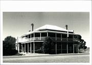
Farm House, 177 Morris Edwards Drive located on a farm on the immediate western edge of the town, is a rustic example of Victorian Georgian architecture, demonstrating early development and making a considerable contribution to the historic townscape of York.
The farm house is in an elevated position a considerable distance from the road, with a hill rising behind. The random stone building has a high-pitched gable roof with face brick gable infill at each end. A low-pitched hipped veranda roof is supported by square timber posts around the perimeter of the building. Difficult to tell if the frontage is symmetrical but likely is. The front door has a three-section fanlight above, and a visible window is a narrow pair of multi-paned casements.
Integrity: High Authenticity: Moderate/High
Fair/good
This information is provided voluntarily as a public service. The information provided is made available in good faith and is derived from sources believed to be reliable and accurate. However, the information is provided solely on the basis that readers will be responsible for making their own assessment of the matters discussed herein and are advised to verify all relevant representations, statements and information.
200 Morris Edwards Drive Daliak
York
Avon Arc
| Type | Status | Date | Documents |
|---|---|---|---|
| Heritage List | Adopted | 25 Nov 2019 |
| Type | Status | Date | Documents |
|---|---|---|---|
| (no listings) |
| Type | Status | Date | Grading/Management | |
|---|---|---|---|---|
| Category | ||||
| Local Heritage Survey | Adopted | 25 Nov 2019 | Grade B | |
Individual Building or Group
| Epoch | General | Specific |
|---|---|---|
| Present Use | RESIDENTIAL | Single storey residence |
| Style |
|---|
| Victorian Georgian |
This information is provided voluntarily as a public service. The information provided is made available in good faith and is derived from sources believed to be reliable and accurate. However, the information is provided solely on the basis that readers will be responsible for making their own assessment of the matters discussed herein and are advised to verify all relevant representations, statements and information.
Constructed from 1860, Constructed from 1880
Farm House 200 Morris Edwards Drive located on a farm on the immediate western edge of the town is good example of the development of a Victorian Georgian farmhouse, demonstrating early settlement and making a considerable contribution to the historic townscape of York.
Set back from the road with paddocks to the rear and side, the farm house site is fenced with mature plantings obscuring views. Single storey; two pavilions semidetached and parallel, both with a hipped roof with a separate hipped skillion surrounding verandah supported by square timber posts. The chimneys on the low-pitched roof of the front cottage is the first development on the site evidenced by the smaller scale and the simple square chimneys. The semi-detached cottage at the rear has a higher pitched roof with taller corbelled chimneys.
Integrity: High Authenticity: Moderate/High
Fair
This information is provided voluntarily as a public service. The information provided is made available in good faith and is derived from sources believed to be reliable and accurate. However, the information is provided solely on the basis that readers will be responsible for making their own assessment of the matters discussed herein and are advised to verify all relevant representations, statements and information.
246 Morris Edwards Drive Daliak
York
Avon Arc
| Type | Status | Date | Documents |
|---|---|---|---|
| (no listings) |
| Type | Status | Date | Documents |
|---|---|---|---|
| (no listings) |
| Type | Status | Date | Grading/Management | |
|---|---|---|---|---|
| Category | ||||
| Local Heritage Survey | Adopted | 25 Nov 2019 | Grade C | |
Individual Building or Group
| Epoch | General | Specific |
|---|---|---|
| Present Use | RESIDENTIAL | Single storey residence |
| Style |
|---|
| Federation Bungalow |
| Type | General | Specific |
|---|---|---|
| Wall | STONE | Other Stone |
This information is provided voluntarily as a public service. The information provided is made available in good faith and is derived from sources believed to be reliable and accurate. However, the information is provided solely on the basis that readers will be responsible for making their own assessment of the matters discussed herein and are advised to verify all relevant representations, statements and information.
Constructed from 1890
Residence, 246 Morris Edwards Drive is good example of the development of a Victorian Georgian farmhouse, demonstrating early settlement and making a considerable contribution to the historic townscape of York.
The single storey residence is located close to the road with paddock area around. The symmetrical form has a simple hipped roof and separate bullnose veranda. The random stone front wall has a rendered dado and is painted. There are painted tuckpointed quoins to the window and door openings and the corners. The windows appear to be double hung sashes and the central front door set has side-lights with dado panels.
Good
This information is provided voluntarily as a public service. The information provided is made available in good faith and is derived from sources believed to be reliable and accurate. However, the information is provided solely on the basis that readers will be responsible for making their own assessment of the matters discussed herein and are advised to verify all relevant representations, statements and information.
49 Ulster Rd Daliak
Fmr 268 Morris Edwards Dr
York
Avon Arc
| Type | Status | Date | Documents |
|---|---|---|---|
| Heritage List | Adopted | 25 Nov 2019 |
| Type | Status | Date | Documents |
|---|---|---|---|
| (no listings) |
| Type | Status | Date | Grading/Management | |
|---|---|---|---|---|
| Category | ||||
| Local Heritage Survey | Adopted | 25 Nov 2019 | Grade B | |
Individual Building or Group
| Epoch | General | Specific |
|---|---|---|
| Present Use | RESIDENTIAL | Single storey residence |
| Style |
|---|
| Federation Bungalow |
| Type | General | Specific |
|---|---|---|
| Wall | BRICK | Face Brick |
This information is provided voluntarily as a public service. The information provided is made available in good faith and is derived from sources believed to be reliable and accurate. However, the information is provided solely on the basis that readers will be responsible for making their own assessment of the matters discussed herein and are advised to verify all relevant representations, statements and information.
Constructed from 1910
Residence, Morris Edwards Drive on corner of Ulster Road is significant as a fine intact representative of a Federation bungalow that makes a significant contribution to the historic townscape of York.
The single storey brick residence occupies a corner location and fronts Ulster Street and Morris Edwards Drive. The site is fully fenced and partially obscured by hedges. The hipped roof is high pitched and features vented gablets at the end of the ridge. The surrounding veranda has a bullnose roof supported by timber posts and decorative timber brackets. The face brickwork is tuckpointed stretcher bond. The symmetrical frontage to Morris Edward Drive has a central door with side and fan lights, flanked by single double-hung timber framed sashes with sidelight panels. The tall chimneys are face brick with corbelled detailing. The two identical random coursed face stone cottages replicate Victorian Georgian style with symmetrical frontages, brick quoined corners, simple hipped roof, separate hipped front veranda roof, multi-paned windows and corbelled brick chimneys.
Two stone cottages further south on the Ulster Road frontage are believed to have been constructed after 1960, likely as part of a tourist hospitality business.
Integrity: High Authenticity: Moderate/High
Good
This information is provided voluntarily as a public service. The information provided is made available in good faith and is derived from sources believed to be reliable and accurate. However, the information is provided solely on the basis that readers will be responsible for making their own assessment of the matters discussed herein and are advised to verify all relevant representations, statements and information.
Off Great Southern Hwy Gilgering
York
Avon Arc
Constructed from 1858
| Type | Status | Date | Documents |
|---|---|---|---|
| Heritage List | Adopted | 25 Nov 2019 |
| Type | Status | Date | Documents |
|---|---|---|---|
| RHP - To be assessed | Current | 11 Jun 2004 |
| Type | Status | Date | Grading/Management | |
|---|---|---|---|---|
| Category | ||||
| Classified by the National Trust | Classified | 11 Jun 2012 | ||
| Aboriginal Heritage Sites Register | Adopted | |||
| Local Heritage Survey | Adopted | 25 Nov 2019 | Grade B | |
· The place aesthetic value as it contributes to streetscape
· The place has scientific value for its unmarked graves
· The place has rarity value as it is an early example of a church with an extensive graveyard.
· The place has representativeness value as it represents a particular style that is not common.
Single storey modest brick church Gable CGI Roof Gothic windows Extensive cemetery surrounding the church
‘York is conspicuous for its handsome churches. The first Anglican Church, dedicated to St John the Evan the Evangelist, was built on the northern edge of Blandstown. The original mud brick structure (1841) was replaced by a brick building in 1861, and served this end of town until 1905, when it was moved, brick by brick, to its present site alongside Holy Trinity for use as a church hall. ‘ ‘The Roman Catholic Church of St Patrick, designed and built by the Reverend Patrick Gibney is Gothic in style and likewise stands alongside the original church. In 1888 the Methodists also built a Gothic Church in stone alongside their little brick mission church. Churches were not confined to the town area. Small Anglican Chapels were built at Tipperary (1892). Greenhills (1882) and the Gilgering Church built in 1858 to serve the farming community as both a school and a religious centre.’ The Gilgering Church was consecrated in 1860 and is the earliest build church in the Avon / York region.
High
Good
| Name | Type | Year From | Year To |
|---|---|---|---|
| designed and built by Rev Patrick Gibney | Architect | - | - |
Individual Building or Group
| Epoch | General | Specific |
|---|---|---|
| Original Use | MONUMENT\CEMETERY | Cemetery |
| Present Use | MONUMENT\CEMETERY | Cemetery |
| Present Use | RELIGIOUS | Church, Cathedral or Chapel |
| Original Use | RELIGIOUS | Church, Cathedral or Chapel |
| Style |
|---|
| Victorian Free Gothic |
| Vernacular |
| Type | General | Specific |
|---|---|---|
| Roof | METAL | Corrugated Iron |
| Wall | BRICK | Common Brick |
| General | Specific |
|---|---|
| SOCIAL & CIVIC ACTIVITIES | Religion |
This information is provided voluntarily as a public service. The information provided is made available in good faith and is derived from sources believed to be reliable and accurate. However, the information is provided solely on the basis that readers will be responsible for making their own assessment of the matters discussed herein and are advised to verify all relevant representations, statements and information.
Constructed from 1858, Constructed from 1880
St Peter’s Anglican Church and Cemetery is significant for the rural aesthetic of the church and cemetery set high on the banks of the Avon River; associations with the local Anglican community, of the first Rector, Rev. Frederick Lynch, and those recorded in the cemetery. It is important for the local community’s sense of place.
The church is set on raised ground west of the Avon River. The rectangular form with gable roof has a small roofed porch on the frontage (west.) It has lancet windows with leaded and stained glass, and a west facing front entrance porch. A metal bell tower stands on the south side of the church. The church is surrounded on three sides by the cemetery. The site of a parsonage and the Gilgering school.
In 1831, Reverend Wittenoom was granted Gwambygine and George Fletcher Moore the adjoining Jilgayria (Gilgering). Church services took place at Oakover from 1840, and the Fleay’s home from 1850s. In 1860 Moore indentured the site for the Anglican church. Hamersley donated the parsonage land. Construction of the church began in 1858. A hand bell summoned the parishioners, and in 1858 the Parker family of Northbourne donated the bell. The church was consecrated by Bishop Hale on 1 July 1860. Rev Lynch and his wife were the only ones to live at the parsonage until his death in 1888 and his wife in 1891, both in the cemetery. The rectory that had been empty since that time and lost its roof in a cyclone in 1943. In 1945 the rectory and school building were demolished. In 2012 the National trust accepted the donation from the church and took over ownership, leasing the property to the newly formed Friends of St Peters Anglican Church.
High
Good
This information is provided voluntarily as a public service. The information provided is made available in good faith and is derived from sources believed to be reliable and accurate. However, the information is provided solely on the basis that readers will be responsible for making their own assessment of the matters discussed herein and are advised to verify all relevant representations, statements and information.
Greenhills
Residence
York
Avon Arc
Constructed from 1899
| Type | Status | Date | Documents |
|---|---|---|---|
| (no listings) |
| Type | Status | Date | Documents |
|---|---|---|---|
| (no listings) |
| Type | Status | Date | Grading/Management | |
|---|---|---|---|---|
| Category | ||||
| (no listings) | ||||
Individual Building or Group
| Epoch | General | Specific |
|---|---|---|
| Present Use | RESIDENTIAL | Single storey residence |
| Original Use | Transport\Communications | Comms: Post or Telegraph Office |
This information is provided voluntarily as a public service. The information provided is made available in good faith and is derived from sources believed to be reliable and accurate. However, the information is provided solely on the basis that readers will be responsible for making their own assessment of the matters discussed herein and are advised to verify all relevant representations, statements and information.
Greenhills
York
Avon Arc
| Type | Status | Date | Documents |
|---|---|---|---|
| (no listings) |
| Type | Status | Date | Documents |
|---|---|---|---|
| (no listings) |
| Type | Status | Date | Grading/Management | |
|---|---|---|---|---|
| Category | ||||
| (no listings) | ||||
Individual Building or Group
| Epoch | General | Specific |
|---|---|---|
| Present Use | VACANT\UNUSED | Vacant\Unused |
| Original Use | COMMERCIAL | Shop\Retail Store {single} |
This information is provided voluntarily as a public service. The information provided is made available in good faith and is derived from sources believed to be reliable and accurate. However, the information is provided solely on the basis that readers will be responsible for making their own assessment of the matters discussed herein and are advised to verify all relevant representations, statements and information.
2 Boyle Rd Greenhills
Lot 1820 on DP 248785
York
Avon Arc
| Type | Status | Date | Documents |
|---|---|---|---|
| Heritage List | Adopted | 25 Nov 2019 |
| Type | Status | Date | Documents |
|---|---|---|---|
| (no listings) |
| Type | Status | Date | Grading/Management | |
|---|---|---|---|---|
| Category | ||||
| Local Heritage Survey | Adopted | 25 Nov 2019 | Grade B | |
Individual Building or Group
| Type | General | Specific |
|---|---|---|
| Roof | METAL | Corrugated Iron |
| Wall | BRICK | Face Brick |
This information is provided voluntarily as a public service. The information provided is made available in good faith and is derived from sources believed to be reliable and accurate. However, the information is provided solely on the basis that readers will be responsible for making their own assessment of the matters discussed herein and are advised to verify all relevant representations, statements and information.
Constructed from 1896
Greenhills bakery (fmr) is historically significant as an important provisioner (baker) in the establishing private town of Greenhills. The value of the place is evidenced in the community efforts to restore the place in 2001. It makes a significant contribution to the Greenhills townsite. On 1 September 1898, the railway came to Greenhills and the private townsite developed around the railways siding (that was previously McMullens property). Greenhills was the railhead until 1908. The town continued to develop around the railway with the Railway Hotel directly opposite the railway station, as is tradition. Next to the Railway Hotel was McMullen’s Hall (1912), and the school and school house (1916) and bakery on the west side of the railway line. A railway station was built, 5 railway houses, a bank and residence, and two garages. In 1924, the York Co-op had a store in Greenhills and in 1937 the CBH bins were constructed at the railway site. Herbert F Taylor was the original baker. Reopened in 2001 by Adele Turner a descendant of the original owner, and Henry Graham Penny the current owner (2001).
The single storey single room building has a gable roof with a single door and double-hung sash window on the front wall. There is another door on the north side. A brick corbelled chimney at the rear evidences the location of the oven.
The private town of Greenhills developed on McMullen’s farm after they successfully lobbied for the railway line east of York to pass through their property. The advent of the railway in 1898 shifted the focus from the original townsite where the church, cemetery, school and Agricultural Hall had been established. The Greenhills Road Board was formed in 1893 with Henry Penny chairman- the area covered from east of York to the South Australian border. The goldrushes meant travellers heading east through the district after getting off the train in York. The hall and school were established in the mid-1890s near Penny’s farm and the church. The Club Hotel was located further away as penny objected to being near his property. McMullens were business people who had established in the area. With the prospect of the railway coming through, they lobbied for it to come through their farm rather than further east along the road near Penny’s farm.
Integrity: Low Authenticity: Moderate
Good
This information is provided voluntarily as a public service. The information provided is made available in good faith and is derived from sources believed to be reliable and accurate. However, the information is provided solely on the basis that readers will be responsible for making their own assessment of the matters discussed herein and are advised to verify all relevant representations, statements and information.
2 Boyle Rd Greenhills
Lot 1820 on Diagram 248785
York
Avon Arc
| Type | Status | Date | Documents |
|---|---|---|---|
| Heritage List | Adopted | 25 Nov 2019 |
| Type | Status | Date | Documents |
|---|---|---|---|
| (no listings) |
| Type | Status | Date | Grading/Management | |
|---|---|---|---|---|
| Category | ||||
| Local Heritage Survey | Adopted | 25 Nov 2019 | Grade B | |
Other Built Type
This information is provided voluntarily as a public service. The information provided is made available in good faith and is derived from sources believed to be reliable and accurate. However, the information is provided solely on the basis that readers will be responsible for making their own assessment of the matters discussed herein and are advised to verify all relevant representations, statements and information.
Greenhills well is of historical significance as a source of water supply for the early settlers and travellers.
The private town of Greenhills developed on McMullen’s farm after they successfully lobbied for the railway line east of York to pass through their property. The advent of the railway in 1898 shifted the focus from the original townsite where the church, cemetery, school and Agricultural hall had been established.
This information is provided voluntarily as a public service. The information provided is made available in good faith and is derived from sources believed to be reliable and accurate. However, the information is provided solely on the basis that readers will be responsible for making their own assessment of the matters discussed herein and are advised to verify all relevant representations, statements and information.
Doodenanning Rd Greenhills
York
Avon Arc
| Type | Status | Date | Documents |
|---|---|---|---|
| (no listings) |
| Type | Status | Date | Documents |
|---|---|---|---|
| (no listings) |
| Type | Status | Date | Grading/Management | |
|---|---|---|---|---|
| Category | ||||
| Local Heritage Survey | Adopted | 25 Nov 2019 | Grade C | |
Individual Building or Group
| Epoch | General | Specific |
|---|---|---|
| Present Use | RESIDENTIAL | Single storey residence |
| Original Use | FARMING\PASTORAL | Homestead |
| Type | General | Specific |
|---|---|---|
| Wall | BRICK | Common Brick |
| General | Specific |
|---|---|
| OCCUPATIONS | Grazing, pastoralism & dairying |
This information is provided voluntarily as a public service. The information provided is made available in good faith and is derived from sources believed to be reliable and accurate. However, the information is provided solely on the basis that readers will be responsible for making their own assessment of the matters discussed herein and are advised to verify all relevant representations, statements and information.
Farmhouse, Doodenanning Road represents a way of life.
The main original building is a ruin and almost inaccessible because of its overgrown state. Thus little idea can be gained of the architectural style.
Integrity: Ruins Authenticity: Ruins
Ruins
This information is provided voluntarily as a public service. The information provided is made available in good faith and is derived from sources believed to be reliable and accurate. However, the information is provided solely on the basis that readers will be responsible for making their own assessment of the matters discussed herein and are advised to verify all relevant representations, statements and information.
Greenhills Rd Greenhills
York
Avon Arc
Constructed from 1912
| Type | Status | Date | Documents |
|---|---|---|---|
| Heritage List | Adopted | 25 Nov 2019 |
| Type | Status | Date | Documents |
|---|---|---|---|
| RHP - Assessed - Below Threshold | Current | 29 Jan 1999 |
| Type | Status | Date | Grading/Management | |
|---|---|---|---|---|
| Category | ||||
| Local Heritage Survey | Adopted | 25 Nov 2019 | Grade B | |
| Library Id | Title | Medium | Year Of Publication |
|---|---|---|---|
| 3719 | Greenhills Hall, Greenhills : conservation plan. | Heritage Study {Cons'n Plan} | 1998 |
Individual Building or Group
| Epoch | General | Specific |
|---|---|---|
| Original Use | SOCIAL\RECREATIONAL | Other Community Hall\Centre |
| Present Use | VACANT\UNUSED | Vacant\Unused |
This information is provided voluntarily as a public service. The information provided is made available in good faith and is derived from sources believed to be reliable and accurate. However, the information is provided solely on the basis that readers will be responsible for making their own assessment of the matters discussed herein and are advised to verify all relevant representations, statements and information.
Constructed from 1912
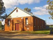
Greenhills Hall represents the essence of a country community. The historic associations with the Greenhills Progress Association and the early settlers of Greenhills, in gaining the railway line to sustain their development, the McMullen families’ facilitation of the community focus for meetings, socialising and celebrations, and the reformed Greenhills Progress Association who have carried on the tradition and celebrated their sense of place. Greenhills Hall is a fine Federation example of a small-town community hall, It makes a substantial contribution to Greenhills Road in Greenhills, opposite the railway facility, and flanked by the Greenhills Inn and the former Post Office.
The single storey rectangular form hall has a gable roof with a timber gable infill to the street front. The symmetrical frontage has a central double entry doors flanked by a stack bond pier each side, and single double-hung sash windows. The sides are delineated into bays by stack bond piers, with a double-hung sash windows central in each bay except where there is a set of double exit doors each side. A skillion roofed kitchen addition extends across the rear of the hall.
The private town of Greenhills developed on McMullen’s farm after they successfully lobbied for the railway line east of York to pass through their property. The advent of the railway in 1898 shifted the focus form the original townsite where the church, cemetery, school and Agricultural Hall had been established. The hall opposite the railway siding was built for Mrs Mary Ann McMullenin 1912, and became the centre of social events in the area. The opening in October 1912 was celebrated with the “scholars of Greenhills State School giving a Grand Variety entertainment at McMullen’s Hall”. After Mrs McMulen died in 1923, her father, Arthur Dinsdale inherited the hall. The Perpetual Trustees became owners in 1929 when Dinsdale died. In 1954 members of the community purchased the hall, and after two successful “Back to Greenhills’ events, the Greenhills Progress Association reformed (originally formed in the late 1890s to get the railway) to ensure the future of the Hall. A crowd of 250 past and present Greenhill’s residents attended the 100th anniversary of the hall in 2012.
Integrity: High Authenticity: Moderate/High
Good
This information is provided voluntarily as a public service. The information provided is made available in good faith and is derived from sources believed to be reliable and accurate. However, the information is provided solely on the basis that readers will be responsible for making their own assessment of the matters discussed herein and are advised to verify all relevant representations, statements and information.
Greenhills Rd Greenhills
Railway Hotel
York
Avon Arc
Constructed from 1910
| Type | Status | Date | Documents |
|---|---|---|---|
| Heritage List | Adopted | 25 Nov 2019 |
| Type | Status | Date | Documents |
|---|---|---|---|
| (no listings) |
| Type | Status | Date | Grading/Management | |
|---|---|---|---|---|
| Category | ||||
| Statewide Hotel Survey | Completed | 01 Nov 1997 | ||
| Local Heritage Survey | Adopted | 25 Nov 2019 | Grade B | |
Individual Building or Group
| Epoch | General | Specific |
|---|---|---|
| Original Use | COMMERCIAL | Hotel, Tavern or Inn |
| Present Use | COMMERCIAL | Hotel, Tavern or Inn |
| Style |
|---|
| Federation Filigree |
| Type | General | Specific |
|---|---|---|
| Roof | METAL | Corrugated Iron |
| Wall | BRICK | Common Brick |
| General | Specific |
|---|---|
| SOCIAL & CIVIC ACTIVITIES | Sport, recreation & entertainment |
| OCCUPATIONS | Hospitality industry & tourism |
This information is provided voluntarily as a public service. The information provided is made available in good faith and is derived from sources believed to be reliable and accurate. However, the information is provided solely on the basis that readers will be responsible for making their own assessment of the matters discussed herein and are advised to verify all relevant representations, statements and information.
Constructed from 1910
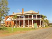
Greenhills Inn is a representative example of Federation Filigree architecture in a country town application and makes a considerable contribution the Greenhills townscape, as a landmark in the Greenhills townsite and informs of the prosperity of the advent of the railway and development of the private town. Strategically located opposite the railway station, the Railway Hotel was the place of hospitality and socialising for traveller and community, in recent decades it has also been the venue for many weddings and celebrations, creating a sense of place valued by many. It is historically significant in the development of Greenhills.
The two storey hotel building has verandas at both floor levels that wrap the street frontage and along the north side with a truncated corner, as if there was a street along the north side. (maybe there was?) The hipped roof is facetted about the truncated corner. The first floor veranda has a separate roof supported by timber posts. The balustrades are decorative (typical of the architectural style). There is a protruding singe storey gable frontage on the north side that terminates the verandas. Tall face brick corbelled chimneys dominate the roof line.
The private town of Greenhills developed on McMullen’s farm after they successfully lobbied for the railway line east of York to pass through their property. The advent of the railway in 1898 shifted the focus from the original townsite where the church, cemetery, school and Agricultural Hall had been established The Greenhills Road Board was formed in 1893 with Henry Penny chairman- the area covered from east of York to the South Australian border. The goldrushes meant travellers heading east through the district after getting off the train in York. The hall and school were established in the mid 1890s near Penny’s farm and the church. The Club Hotel was located further away as penny objected to being near his property. McMullens were business people who had established in the area. With the prospect of the railway coming through, they lobbied for it to come through their farm rather than further east along the road near Penny’s farm. On 1 September 1898, the railway came to Greenhills and the private townsite developed around the railways siding (that was previously McMullens property). Greenhills was the railhead until 1908. The town continued to develop around the railway with the Railway Hotel directly opposite the railway station, as is tradition. Next to the Railway Hotel was McMullen’s Hall (1912), and the school and school house (1916) and bakery on the west side of the railway line. A railway station was built, 5 railway houses, a bank and residence, and two garages. The settlement near the church and the Club Hotel declined with the focus in the town. In 1924, the York o-op had a store in Greenhills and in 1937 the CBH bins were constructed at the railway site. The Railway Hotel was later renamed Greenhills Hotel/ Tavern/Inn.
Moderate/Good
Fair/good
This information is provided voluntarily as a public service. The information provided is made available in good faith and is derived from sources believed to be reliable and accurate. However, the information is provided solely on the basis that readers will be responsible for making their own assessment of the matters discussed herein and are advised to verify all relevant representations, statements and information.
466 Greenhills Road Greenhills
Lot 30 on Plan 300078
York
Avon Arc
| Type | Status | Date | Documents |
|---|---|---|---|
| Heritage List | Adopted | 25 Nov 2019 |
| Type | Status | Date | Documents |
|---|---|---|---|
| (no listings) |
| Type | Status | Date | Grading/Management | |
|---|---|---|---|---|
| Category | ||||
| Local Heritage Survey | Adopted | 25 Nov 2019 | Grade B | |
Individual Building or Group
| Style |
|---|
| Federation Bungalow |
This information is provided voluntarily as a public service. The information provided is made available in good faith and is derived from sources believed to be reliable and accurate. However, the information is provided solely on the basis that readers will be responsible for making their own assessment of the matters discussed herein and are advised to verify all relevant representations, statements and information.
Constructed from 1899
Greenhills Post Office (fmr) and Residence is historically significant in representing an essential service and social interaction in the developing private town of in Greenhills after the advent of the railway in 1898, making a significant contribution to the development of the town and the streetscape.
The single storey masonry building has been rendered. The hipped roof extends in a skillion across the entire front veranda that is formed into three bays with timber posts and simple curved timber valance. The frontage shows the entry on the south, central window and a window and ledge evidencing the post office function on the north side of the front. A tall roughcast chimney with deep moulded detail is evident central on the roof with double clay pots to the front.
Moderate
Good
This information is provided voluntarily as a public service. The information provided is made available in good faith and is derived from sources believed to be reliable and accurate. However, the information is provided solely on the basis that readers will be responsible for making their own assessment of the matters discussed herein and are advised to verify all relevant representations, statements and information.
Quairading Rd Greenhills
Cnr Greenhills South Rd and Quairading Rd
York
Avon Arc
Constructed from 1912 to 2001
| Type | Status | Date | Documents |
|---|---|---|---|
| Heritage List | Adopted | 25 Nov 2019 | |
| State Register | Registered | 17 Nov 2006 | HCWebsite.Listing+ListingDocument, HCWebsite.Listing+ListingDocument |
| Type | Status | Date | Documents |
|---|---|---|---|
| (no listings) |
| Type | Status | Date | Grading/Management | |
|---|---|---|---|---|
| Category | ||||
| Local Heritage Survey | Adopted | 25 Nov 2019 | Grade A | |
| Anglican Church Inventory | YES | 31 Jul 1996 | ||
St Andrew’s Anglican Church has received limited maintenance over a period of many years. However, the cumulative effects of weathering and the lack of programmed maintenance and financial resources is evident on the exterior. The interior has been maintained at a relatively high level. Overall the place is in a fair to good condition. The Cemetery is generally in good condition. The grounds appear to be maintained. The perimeter fence on the east, south and west sides is in fair condition and the front fence and gate are in good condition.
| Library Id | Title | Medium | Year Of Publication |
|---|---|---|---|
| 5143 | St Andrew's Anglican Church, Greenhills : conservation plan. | Heritage Study {Cons'n Plan} | 2001 |
Individual Building or Group
| Epoch | General | Specific |
|---|---|---|
| Original Use | MONUMENT\CEMETERY | Cemetery |
| Present Use | RELIGIOUS | Church, Cathedral or Chapel |
| Original Use | RELIGIOUS | Church, Cathedral or Chapel |
| Style |
|---|
| Federation Carpenter Gothic |
| Type | General | Specific |
|---|---|---|
| Wall | TIMBER | Weatherboard |
| General | Specific |
|---|---|
| SOCIAL & CIVIC ACTIVITIES | Religion |
| SOCIAL & CIVIC ACTIVITIES | Cultural activities |
This information is provided voluntarily as a public service. The information provided is made available in good faith and is derived from sources believed to be reliable and accurate. However, the information is provided solely on the basis that readers will be responsible for making their own assessment of the matters discussed herein and are advised to verify all relevant representations, statements and information.
Constructed from 2001, Constructed from 1912
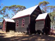
Heritage Value – A rare example of church and cemetery that is no longer associated with a town as it is the only remnant remaining of the former town of Greenhills. Historic Value – The Church and Cemetery was developed and maintained by the Penny family who are prominent community members in the Greenhills district, having been one of the earliest members in the Greenhills area. Penny family is one of the earliest European settlers in the area, being involved in local government and having lent the name from their farm ‘Green Hills’ to the area and church. Social Value – This has been an important social and religious centre for the Anglican community since its construction in 1912, with generations of funerals, baptisms and marriages.
St Andrew’s Anglican Church & Cemetery is a one storey timber weatherboard structure demonstrating characteristics of Federation Carpenter Gothic architectural style with an attached cemetery. It is is the only remaining element of the former town of Greenhills, and a rare example of church and cemetery that are no longer associated with a town. St Andrew’s Anglican Church & Cemetery is rare in Western Australia as an extant, in use, timber weatherboard church with a highly finished interior, and is a good representative example of a rural church of Federation Carpenter Gothic style of architecture.
Integrity: Good Authenticity: Good
Good
| Owner | Category |
|---|---|
| Dept of Planning and Infrastructure | State Gov't |
| The Diocesan Trustees- Anglican Church of WA | Church Property |
| The Anglican Ministering Community of York | Church Property |
This information is provided voluntarily as a public service. The information provided is made available in good faith and is derived from sources believed to be reliable and accurate. However, the information is provided solely on the basis that readers will be responsible for making their own assessment of the matters discussed herein and are advised to verify all relevant representations, statements and information.
Cnr York & Quairading Rd Greenhills
Inc: Garden, Barn, Stables & Smokehouse
Greenhills Farm
Korrawilla
York
Avon Arc
Constructed from 1930, Constructed from 1860
| Type | Status | Date | Documents |
|---|---|---|---|
| Heritage List | Adopted | 25 Nov 2019 | |
| State Register | Registered | 14 Dec 2001 | HCWebsite.Listing+ListingDocument, HCWebsite.Listing+ListingDocument |
| Type | Status | Date | Documents |
|---|---|---|---|
| (no listings) |
| Type | Status | Date | Grading/Management | |
|---|---|---|---|---|
| Category | ||||
| Register of the National Estate | Permanent | 28 Sep 1982 | ||
| Classified by the National Trust | Classified | 04 Feb 1980 | ||
| Local Heritage Survey | Adopted | 25 Nov 2019 | Grade A | |
1880 homestead in poor condition however other buildings are in fair to good condition
| Library Id | Title | Medium | Year Of Publication |
|---|---|---|---|
| 7715 | Korrawilla Greenhills conservation works: final report. | Conservation works report | 2006 |
| 4578 | Korrawilla (formerly Green Hills Farm) : conservation plan. | Heritage Study {Cons'n Plan} | 2000 |
| 7334 | Korrawilla Greeenhills : conservation works (final report). | Conservation works report | 2005 |
| 5526 | Korrawilla, Greenhills : conservation works (final report). | Conservation works report | 2002 |
| 5166 | Korrawilla, Greenhills : conservation works : final report / Laura Gray. | Heritage Study {Other} | 2001 |
Individual Building or Group
| Epoch | General | Specific |
|---|---|---|
| Other Use | Transport\Communications | Comms: Post or Telegraph Office |
| Present Use | FARMING\PASTORAL | Homestead |
| Original Use | FARMING\PASTORAL | Stable |
| Original Use | FARMING\PASTORAL | Shed or Barn |
| Original Use | FARMING\PASTORAL | Homestead |
| Style |
|---|
| Victorian Georgian |
| Type | General | Specific |
|---|---|---|
| Wall | BRICK | Common Brick |
| Roof | METAL | Corrugated Iron |
| General | Specific |
|---|---|
| OCCUPATIONS | Grazing, pastoralism & dairying |
| TRANSPORT & COMMUNICATIONS | Mail services |
| PEOPLE | Early settlers |
| DEMOGRAPHIC SETTLEMENT & MOBILITY | Land allocation & subdivision |
This information is provided voluntarily as a public service. The information provided is made available in good faith and is derived from sources believed to be reliable and accurate. However, the information is provided solely on the basis that readers will be responsible for making their own assessment of the matters discussed herein and are advised to verify all relevant representations, statements and information.
Constructed from 1860, Constructed from 1880
Cultural heritage significance for the following reasons: 1. Example of a substantial agricultural settlement in the relatively remote pastoral area east of York in the 1860s. 2. The building is the oldest established property in the Greenhills area. The building contains evidence of building techniques from the early period of settlement. 3. Forms a significant cultural environment in a rural agricultural setting. 4. A social centre of the Greenhills district from circa 1865 to c.1920 as the store, post office, venue for Anglican Church services (pre 1882) and social events in the barn and tennis. 5. Significant impact on the wheatbelt vista. 6. Significant associations with the Penny family who established, developed and sustained over five generations from 1860s to now.
A brick homestead located off Quairading Road. Examples of Victorian- Georgian style in a rural setting and demonstrates decorative variations of Flemish bond reverse tone brickwork. A large hipped roof homestead. The two wings of the building form a courtyard and are constructed of bricks handmade on the property. The wings are one room deep and surrounded by verandahs which retain their original brick paving. The original shingled roof remains the same in some sections but is now covered by iron.
Integrity: High Authenticity: High
Good
| Ref ID No | Ref Name | Ref Source | Ref Date |
|---|---|---|---|
| Heritage Council’s Website | HCWA |
This information is provided voluntarily as a public service. The information provided is made available in good faith and is derived from sources believed to be reliable and accurate. However, the information is provided solely on the basis that readers will be responsible for making their own assessment of the matters discussed herein and are advised to verify all relevant representations, statements and information.
Great Southern Highway Inkpen
Lot 28118 on Plan 43137
13 Mile Brook
Convict Road Remnants
York
Avon Arc
Constructed from 1860
| Type | Status | Date | Documents |
|---|---|---|---|
| Heritage List | Adopted | 25 Nov 2019 |
| Type | Status | Date | Documents |
|---|---|---|---|
| RHP - To be assessed | Current | 30 Jun 2023 |
| Type | Status | Date | Grading/Management | |
|---|---|---|---|---|
| Category | ||||
| Local Heritage Survey | Adopted | 25 Nov 2019 | Grade B | |
The place is a modest example of a stone road and culvert likely constructed by convicts or ticket-of-leave men as part of extensive public works that substantially improved transport infrastructure.
The place is likely to reveal archaeological information about the construction of the colony’s early infrastructure.
The place comprises areas of stone remnants of the road between Perth and York estimated to be around 200 metres long by 3 metres wide, with evidence of the formation across the crossing of Thirteen Mile Brook and small areas of rounded ‘cobble’ stones. The road is paved with pebbles and a compacted lateritic pea gravel surface and edged on the north side with small granite blocks. The brook crossing comprises the remnants of what was likely a dry stone walled culvert comprising a mixture of smoothed granite rocks which may have been existing in the riverbed, fieldstone and dressed quarried blocks, with an infill of smaller granite rocks. The crossing has partially been washed out and the construction technique of the culvert is visible as a cross-section in the riverbank, although it is not clear if the blocks extend under the road beyond the crossing. Overgrowth of ground cover scrub and trees at the site may be obscuring further physical evidence.
Convict Road and Culvert Remnants, off Wambyn Rd, Inkpen is situated on the former York Road alignment on the northern side of the current Great Southern Highway, with a granite ford crossing at Thirteen Mile Brook. Thirteen Mile Brook is a seasonal stream which flows northwards and is subject to heavy rainfall and flash flooding. The various forms of the remnant blocks at the crossing indicate some were likely existing on site, and others collected or quarried locally. Convict Road and Culvert Remnants, off Wambyn Rd, Inkpen dates to the convict era and has been attributed to convict labour, however this is unconfirmed. Thirteen Mile Brook was mentioned in association with works on the road between York and Guildford on multiple occasions during the 1860s. £150 was provided by the colonial government in 1861 for the repair of the worst section of road between Cut Hill and Thirteen Mile Gully, which was done by tender. In 1867 it was reported that Assistant Warder Bovell’s road party of twelve men with one horse and three carts was located at 13 mile York Road. A tender to sink a well at Thirteen Mile Gully was accepted in 1870, and in 1926 the well was cleaned out, along with Ronan’s Well. A pool of water in Thirteen Mile Brook adjacent to the stone crossing may be the mentioned well, however this is unconfirmed. The remains of an 1862 convict-associated well and an earlier c. 1832 well are situated approximately 2 kilometres to the east of Convict Road and Culvert Remnants, off Wambyn Rd, Inkpen at Thirteen Mile Brook’s feeder creek, St Ronan’s Brook. A temporary road party station was established at St Ronan’s Well and used in the 1860s by convicts employed on repairs of the York Road. The section of Guildford to York Road on which Convict Road and Culvert Remnants, off Wambyn Rd, Inkpen is situated, currently Great Southern Highway, was realigned to the south in the period since construction leaving the original road unused.
Historic Site
| Epoch | General | Specific |
|---|---|---|
| Present Use | VACANT\UNUSED | Vacant\Unused |
| Original Use | Transport\Communications | Road: Other |
| Type | General | Specific |
|---|---|---|
| Other | STONE | Laterite |
| Other | STONE | Granite |
| General | Specific |
|---|---|
| Governing | Law, Order and Defence |
| Economy | Workers and Working |
| Infrastructure | Transport and Communications |
This information is provided voluntarily as a public service. The information provided is made available in good faith and is derived from sources believed to be reliable and accurate. However, the information is provided solely on the basis that readers will be responsible for making their own assessment of the matters discussed herein and are advised to verify all relevant representations, statements and information.
The Convict road remnants are historically significant for the associations with convict period of York’s development and the critical link between Perth and York where the first inland town in Western Australia was developing.
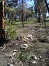
Remnants of the road construction some evidence in formation, across the brook crossing and small random areas of the rounded ‘cobble’ stones.
The Perth to York Road was constructed by the convicts to upgrade the track between Perth and the first inland farm in WA in York. There are very few remnants remaining of the original road construction.
This information is provided voluntarily as a public service. The information provided is made available in good faith and is derived from sources believed to be reliable and accurate. However, the information is provided solely on the basis that readers will be responsible for making their own assessment of the matters discussed herein and are advised to verify all relevant representations, statements and information.