Local Government
Coolgardie
Region
Goldfields
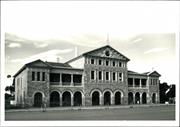
61 Sylvester St Coolgardie
also known as 62-70 Bayley St
Government Building
Coolgardie
Goldfields
Constructed from 1898
| Type | Status | Date | Documents |
|---|---|---|---|
| State Register | Registered | 04 May 2001 | HCWebsite.Listing+ListingDocument, HCWebsite.Listing+ListingDocument |
| Type | Status | Date | Documents |
|---|---|---|---|
| (no listings) |
| Type | Status | Date | Grading/Management | |
|---|---|---|---|---|
| Category | ||||
| Classified by the National Trust | Classified | 27 Oct 1976 | ||
| Register of the National Estate | Permanent | 21 Mar 1978 | ||
| Municipal Inventory | Adopted | 27 Jul 1995 | Category 1 | |
A two storeyed building constructed of concrete foundations, stone and brick walls and with steel roof. It has a colonnaded front facade and first floor balconies. Faced granite in large blocks support the columns and arches.
| Name | Type | Year From | Year To |
|---|---|---|---|
| George Temple Poole | Architect | - | - |
| John (Harry) Grainger | Architect | - | - |
| Library Id | Title | Medium | Year Of Publication |
|---|---|---|---|
| 3732 | Coolgardie Wardens Court (Coolgardie Government Building) Conservation Plan | Heritage Study {Cons'n Plan} | 1998 |
| 6926 | Coolgardie Public Building, 62-70 Bayley Street, Coolgardie WA : reparations to the stonework. | Conservation works report | 2004 |
Individual Building or Group
| Epoch | General | Specific |
|---|---|---|
| Other Use | GOVERNMENTAL | Other |
| Original Use | GOVERNMENTAL | Other |
| Present Use | EDUCATIONAL | Museum |
| Other Use | COMMERCIAL | Bank |
| Style |
|---|
| Federation Free Classical |
| Type | General | Specific |
|---|---|---|
| Roof | METAL | Steel |
| Wall | STONE | Sandstone, other |
| General | Specific |
|---|---|
| SOCIAL & CIVIC ACTIVITIES | Government & politics |
This information is provided voluntarily as a public service. The information provided is made available in good faith and is derived from sources believed to be reliable and accurate. However, the information is provided solely on the basis that readers will be responsible for making their own assessment of the matters discussed herein and are advised to verify all relevant representations, statements and information.
An impressive and well preserved government building of the late 1890's, representing the style of local buildings and the use of local stone.
The building is a grand two storey structure, finely detailed and executed and well preserved. The building is symmetrical about a tall central section which houses the original courthouse and public gallery. The west wing houses the Mining Registrar's office and the new court and the west wing a museum. The building is constructed of finely dressed stone in a random pattern. There is stucco detailing around the windows and doors and on the ground floor arcade and first floor balconies. The roof is tiled, the tiles having been imported from Marseilles.
assessment 1976 construction 1898 Builder John Philip est cost £10,825 Warden's Court and government offices court, bank, museum, mines office
This information is provided voluntarily as a public service. The information provided is made available in good faith and is derived from sources believed to be reliable and accurate. However, the information is provided solely on the basis that readers will be responsible for making their own assessment of the matters discussed herein and are advised to verify all relevant representations, statements and information.
Constructed from 1898
An impressive and well preserved Government building of the late 1890s, representing the style of local buildings and using local stone. Characteristic of the heyday of the Goldfields prosperity. A critical part of the Bayley Street precinct and its most imposing structure.
Includes principal offices of the Mines Department. Two storey, Freestyle Classical building with a colonnaded front facade and first floor balconies. The ground floor includes; the colonnaded front, vestibules and a back verandah and the first floor; the Warden's Court, general office, Warden's rooms and office; rooms for the Jury . Police, Solicitors, Clerk of Courts, Press and Witnesses; and colonnaded balconies. It now houses a good museum in part of the building and the Tourist Bureau.
The second major government building in Coolgardie after the Post Office. Designed by George Temple Poole, one of the colony's most influential architects and Superintendent of the Public Works Department and Colonial Architect from 1891 - 1896. It was the second scheme, the previous proposal being for a site in Hunt Street.
High
Good
| Name | Type | Year From | Year To |
|---|---|---|---|
| George Temple Poole | Architect | - | - |
| John (Harry) Grainger | Architect | - | - |
| Owner | Category |
|---|---|
| Minister for Works | State Gov't |
This information is provided voluntarily as a public service. The information provided is made available in good faith and is derived from sources believed to be reliable and accurate. However, the information is provided solely on the basis that readers will be responsible for making their own assessment of the matters discussed herein and are advised to verify all relevant representations, statements and information.
61 Sylvestor St Coolgardie
Coolgardie
Goldfields
| Type | Status | Date | Documents |
|---|---|---|---|
| (no listings) |
| Type | Status | Date | Documents |
|---|---|---|---|
| (no listings) |
| Type | Status | Date | Grading/Management | |
|---|---|---|---|---|
| Category | ||||
| (no listings) | ||||
Individual Building or Group
| Epoch | General | Specific |
|---|---|---|
| COMMERCIAL | Other |
This information is provided voluntarily as a public service. The information provided is made available in good faith and is derived from sources believed to be reliable and accurate. However, the information is provided solely on the basis that readers will be responsible for making their own assessment of the matters discussed herein and are advised to verify all relevant representations, statements and information.

80 Taylor St Coolgardie
Between Wilson and Lefroy Sts
House
Coolgardie
Goldfields
Constructed from 1897
| Type | Status | Date | Documents |
|---|---|---|---|
| State Register | Removed | 09 Nov 1993 | HCWebsite.Listing+ListingDocument |
| Type | Status | Date | Documents |
|---|---|---|---|
| (no listings) |
| Type | Status | Date | Grading/Management | |
|---|---|---|---|---|
| Category | ||||
| Municipal Inventory | Adopted | 27 Jul 1995 | Category 1 | |
| Register of the National Estate | Permanent | 21 Mar 1978 | ||
| Classified by the National Trust | Classified | 27 Oct 1976 | ||
| Restrictive Covenant | YES | |||
| Name | Type | Year From | Year To |
|---|---|---|---|
| John Grainger | Architect | - | - |
Individual Building or Group
| Epoch | General | Specific |
|---|---|---|
| Original Use | Transport\Communications | Water: Housing or Quarters |
| Original Use | Transport\Communications | Water: Office or Administration Bld |
| Present Use | RESIDENTIAL | Single storey residence |
| Type | General | Specific |
|---|---|---|
| Roof | METAL | Corrugated Iron |
| Wall | STONE | Sandstone, other |
| General | Specific |
|---|---|
| DEMOGRAPHIC SETTLEMENT & MOBILITY | Workers {incl. Aboriginal, convict} |
| DEMOGRAPHIC SETTLEMENT & MOBILITY | Settlements |
This information is provided voluntarily as a public service. The information provided is made available in good faith and is derived from sources believed to be reliable and accurate. However, the information is provided solely on the basis that readers will be responsible for making their own assessment of the matters discussed herein and are advised to verify all relevant representations, statements and information.
Constructed from 1897
A substantial building of architectural significance which demonstrates an indigenous approach to a building of former administrative importance, and linked to the historic Mundaring to Coolgardie Pipeline.
A large single storey building of domestic character with coursed rubble sandstone walls with brick quoins, stuccoed parapets and a entrance portico with arched openings and a stucco pediment with the words 'Mines Water Supply Office 1897' in raised letters. The roof is of corrugated iron and wide verandahs surround most of the building. The original timber post fence remain as well as several large gum trees.
Built in 1897 to house the needs of the resident water supply staff, it is an integral part of the management of the ambitious Mundering to Kalgoorlie pipeline designed by John Grainger, of the Public Works Department, and built in 1897.
High
Good
| Name | Type | Year From | Year To |
|---|---|---|---|
| John Grainger | Architect | - | - |
| Ref ID No | Ref Name | Ref Source | Ref Date |
|---|---|---|---|
| Webb, M&A "The Centennial History of Kalgoorlie-Boulder" | 1993 | ||
| National Trust Citation |
| Owner | Category |
|---|---|
| D. Oliver | Other Private |
This information is provided voluntarily as a public service. The information provided is made available in good faith and is derived from sources believed to be reliable and accurate. However, the information is provided solely on the basis that readers will be responsible for making their own assessment of the matters discussed herein and are advised to verify all relevant representations, statements and information.
A substantial building in good condition, demonstrating an indirect approach to a building of importance
A large single storey building, domestic in character, built in 1897 to house the needs of the resident Coolgardie water supply staff. Stone walls with brick quoins and stuccoed parapets, CGI roof and wide verandahs around most walls of the building.
Assessment 1976 Construction 1897 Original Use : Water Supply Office Current use: House
This information is provided voluntarily as a public service. The information provided is made available in good faith and is derived from sources believed to be reliable and accurate. However, the information is provided solely on the basis that readers will be responsible for making their own assessment of the matters discussed herein and are advised to verify all relevant representations, statements and information.
Victoria Rock Rd Coolgardie
Coolgardie
Goldfields
| Type | Status | Date | Documents |
|---|---|---|---|
| (no listings) |
| Type | Status | Date | Documents |
|---|---|---|---|
| (no listings) |
| Type | Status | Date | Grading/Management | |
|---|---|---|---|---|
| Category | ||||
| Municipal Inventory | Adopted | 27 Jul 1995 | Category 2 | |
Landscape
| Epoch | General | Specific |
|---|---|---|
| Present Use | SOCIAL\RECREATIONAL | Other |
| Original Use | SOCIAL\RECREATIONAL | Other |
This information is provided voluntarily as a public service. The information provided is made available in good faith and is derived from sources believed to be reliable and accurate. However, the information is provided solely on the basis that readers will be responsible for making their own assessment of the matters discussed herein and are advised to verify all relevant representations, statements and information.
Significant natural place of social importance as a visiting destination.
258 hectare nature reserve
This information is provided voluntarily as a public service. The information provided is made available in good faith and is derived from sources believed to be reliable and accurate. However, the information is provided solely on the basis that readers will be responsible for making their own assessment of the matters discussed herein and are advised to verify all relevant representations, statements and information.
Victoria Rock Rd 30 k SW of Coolgardie
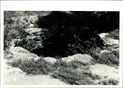
Situated near the eastern base of Gnarlbine Rock. Well is in reserve 2180.
Gnarlbine Well (Well No.22)
Coolgardie
Goldfields
Constructed from 1863
| Type | Status | Date | Documents |
|---|---|---|---|
| State Register | Registered | 28 Aug 2001 | HCWebsite.Listing+ListingDocument, HCWebsite.Listing+ListingDocument |
| Type | Status | Date | Documents |
|---|---|---|---|
| (no listings) |
| Type | Status | Date | Grading/Management | |
|---|---|---|---|---|
| Category | ||||
| Classified by the National Trust | Classified | 06 Dec 1976 | ||
| Wells of Explorer Charles Hunt Survey | Recorded | 01 Nov 1991 | ||
| Register of the National Estate | Permanent | 21 Mar 1978 | ||
| Municipal Inventory | Adopted | 27 Jul 1995 | Category 2 | |
24806 Hunt's Wells Group
Originally an Aboriginal waterhole on the edge of Gnarlbine Rock. The water source was discovered by Lefroy in 1863 and subsequently became an important watering place for explorers and prospectors. It is a stone well, 3 metres in diameter and 2 metres deep, and is now dry. A plaque has been mounted nearby.
Historic site
| Epoch | General | Specific |
|---|---|---|
| Present Use | VACANT\UNUSED | Vacant\Unused |
| Original Use | Transport\Communications | Water: Other |
| Type | General | Specific |
|---|---|---|
| Wall | STONE | Granite |
| General | Specific |
|---|---|
| DEMOGRAPHIC SETTLEMENT & MOBILITY | Aboriginal Occupation |
| DEMOGRAPHIC SETTLEMENT & MOBILITY | Settlements |
| DEMOGRAPHIC SETTLEMENT & MOBILITY | Exploration & surveying |
This information is provided voluntarily as a public service. The information provided is made available in good faith and is derived from sources believed to be reliable and accurate. However, the information is provided solely on the basis that readers will be responsible for making their own assessment of the matters discussed herein and are advised to verify all relevant representations, statements and information.
An historic site associated with the first explorers and early prospectors in the area.
Assessment 1976 'Originally an aboriginal water hole, the soak was 'discovered' by Lefroy 1863 and became an important watering place for explorers and prospectors. At some later date it wa constructed as a well (sstone lined)
This information is provided voluntarily as a public service. The information provided is made available in good faith and is derived from sources believed to be reliable and accurate. However, the information is provided solely on the basis that readers will be responsible for making their own assessment of the matters discussed herein and are advised to verify all relevant representations, statements and information.
Constructed from 1863
A place of substantial historical significance, the waterhole having been a watering place for Aborigines and an important source of water for early white explorers and prospectors.
Originally an Aboriginal water hole on the edge of the Gnarlbine Rock, the water source was discovered by Lefroy in 1863 and subsequently became an important watering place for explorers and prospectors. It is a stone well 3 meters in diameter and 2 meters deep, and is now dry. A plaque has been mounted nearby. The reserve comprises 640 acres.
An early source of water for the district.
| Ref ID No | Ref Name | Ref Source | Ref Date |
|---|---|---|---|
| Webb, M & A "The Centennial History of Kalgoorlie-Boulder" | 1993 |
| Owner | Category |
|---|---|
| Crown Land | Commonwealth Gov't |
This information is provided voluntarily as a public service. The information provided is made available in good faith and is derived from sources believed to be reliable and accurate. However, the information is provided solely on the basis that readers will be responsible for making their own assessment of the matters discussed herein and are advised to verify all relevant representations, statements and information.
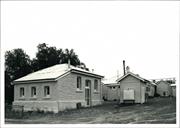
Wilkie St Coolgardie
Health Centre and Trees
Coolgardie
Goldfields
Constructed from 1897
| Type | Status | Date | Documents |
|---|---|---|---|
| (no listings) |
| Type | Status | Date | Documents |
|---|---|---|---|
| (no listings) |
| Type | Status | Date | Grading/Management | |
|---|---|---|---|---|
| Category | ||||
| Municipal Inventory | Adopted | 27 Jul 1995 | Category 2 | |
| Classified by the National Trust | Recorded | 27 Oct 1976 | ||
| Register of the National Estate | Registered | 21 Mar 1978 | ||
| Library Id | Title | Medium | Year Of Publication |
|---|---|---|---|
| 293 | Coolgardie hospital redevelopment : national estate grant programme. | Report | 1990 |
Individual Building or Group
| Epoch | General | Specific |
|---|---|---|
| Present Use | HEALTH | Other |
| Original Use | HEALTH | Hospital |
| Type | General | Specific |
|---|---|---|
| Wall | BRICK | Common Brick |
| Wall | STONE | Other Stone |
| Roof | METAL | Corrugated Iron |
| General | Specific |
|---|---|
| SOCIAL & CIVIC ACTIVITIES | Community services & utilities |
This information is provided voluntarily as a public service. The information provided is made available in good faith and is derived from sources believed to be reliable and accurate. However, the information is provided solely on the basis that readers will be responsible for making their own assessment of the matters discussed herein and are advised to verify all relevant representations, statements and information.
Constructed from 1897
Important as part of the Coolgardie story reflecting the commitment of the state to provide regional services.
A cottage hospital with multiple additions in sympathy with the early structures resulting in an elegant accumulation of modest utilitarian structures.
Coolgardie's government hospital buildings survive, many of the others have perished. It is important as a representative type that demonstrates a committment of government to the Public Hospital system, in a year when there was considerable expenditure on government hospitals. The first St John of God's hospital was also in Coolgardie.
Moderate
Good
| Ref ID No | Ref Name | Ref Source | Ref Date |
|---|---|---|---|
| Webb, M&A "The Centennial History of Kalgoorlie-Boulder" | 1993 |
| Owner | Category |
|---|---|
| West Australian Department of Health | State Gov't |
This information is provided voluntarily as a public service. The information provided is made available in good faith and is derived from sources believed to be reliable and accurate. However, the information is provided solely on the basis that readers will be responsible for making their own assessment of the matters discussed herein and are advised to verify all relevant representations, statements and information.
103 Woodward St Coolgardie
Coolgardie
Goldfields
Constructed from 1896
| Type | Status | Date | Documents |
|---|---|---|---|
| (no listings) |
| Type | Status | Date | Documents |
|---|---|---|---|
| (no listings) |
| Type | Status | Date | Grading/Management | |
|---|---|---|---|---|
| Category | ||||
| Municipal Inventory | Adopted | 27 Jul 1995 | Category 2 | |
| Register of the National Estate | Permanent | 21 Mar 1978 | ||
| Classified by the National Trust | Classified | 27 Oct 1976 | ||
Individual Building or Group
| Epoch | General | Specific |
|---|---|---|
| Original Use | Transport\Communications | Rail: Housing or Quarters |
| Present Use | RESIDENTIAL | Single storey residence |
| Type | General | Specific |
|---|---|---|
| Wall | STONE | Other Stone |
| Roof | METAL | Corrugated Iron |
| General | Specific |
|---|---|
| DEMOGRAPHIC SETTLEMENT & MOBILITY | Settlements |
This information is provided voluntarily as a public service. The information provided is made available in good faith and is derived from sources believed to be reliable and accurate. However, the information is provided solely on the basis that readers will be responsible for making their own assessment of the matters discussed herein and are advised to verify all relevant representations, statements and information.
The group demonstrates a particular style in building, one of substance and peaanence when compared with the bulk of the CGI clad timber framed housing in the town and forms part of the railway establishement in Coolgardie.
A house built for railway employees. It is a simple rectanguar stone building with gabled corrugated iron roof and has five rooms plus weatherboard additions at the back. The house is close to its original condition.
Assessment 1976
This information is provided voluntarily as a public service. The information provided is made available in good faith and is derived from sources believed to be reliable and accurate. However, the information is provided solely on the basis that readers will be responsible for making their own assessment of the matters discussed herein and are advised to verify all relevant representations, statements and information.
Constructed from 1896
Part of a group of railway houses with 105 and 107 Woodward Street, but a larger example. The group demonstrates a particular style in building, one of substance and permanence compared to the bulk of timber framed corrugated iron clad housing in the town. They are an integral part of this important complex of railway buildings in Coolgardie that were vital to the development and history of the Eastern Goldfields.
Stone cottage with corrugated iron roof built in 1896 by the Railway Authority for railway employees. A simple rectangular building with a gabled roof, 5 rooms plus weatherboard additions at the back.
A part of the railway building complex which was a vital communications and transport link for the isolated town. This building accommodated a higher ranked railway worker and his family.
High
Good
| Owner | Category |
|---|---|
| E. Thomas | Other Private |
This information is provided voluntarily as a public service. The information provided is made available in good faith and is derived from sources believed to be reliable and accurate. However, the information is provided solely on the basis that readers will be responsible for making their own assessment of the matters discussed herein and are advised to verify all relevant representations, statements and information.
105 Woodward St Coolgardie
Coolgardie
Goldfields
| Type | Status | Date | Documents |
|---|---|---|---|
| (no listings) |
| Type | Status | Date | Documents |
|---|---|---|---|
| (no listings) |
| Type | Status | Date | Grading/Management | |
|---|---|---|---|---|
| Category | ||||
| Municipal Inventory | Adopted | 27 Jul 1995 | Category 2 | |
Individual Building or Group
| Epoch | General | Specific |
|---|---|---|
| Present Use | RESIDENTIAL | Single storey residence |
| Original Use | RESIDENTIAL | Single storey residence |
| Type | General | Specific |
|---|---|---|
| Roof | METAL | Corrugated Iron |
| Wall | STONE | Local Stone |
| General | Specific |
|---|---|
| TRANSPORT & COMMUNICATIONS | Rail & light rail transport |
| DEMOGRAPHIC SETTLEMENT & MOBILITY | Workers {incl. Aboriginal, convict} |
This information is provided voluntarily as a public service. The information provided is made available in good faith and is derived from sources believed to be reliable and accurate. However, the information is provided solely on the basis that readers will be responsible for making their own assessment of the matters discussed herein and are advised to verify all relevant representations, statements and information.
Constructed from 1896
01738 Two Railway Houses (fmr) & Trees
The group demonstrates a particular style in building, of substance and permanence compared to the bulk of timber framed corrugated iron clad housing in the town. They are on integral part of this important complex of railway buildings in Coolgardie that were vital to the development and history of the Eastern Goldfields.
One of three houses for railway employees built in Woodward Street in a distinctive style using local stone and a corrugated iron roof. A simple, 3 room, rectangular building with a gabled roof and weatherboard clad additions to the rear. There are 2 large pepper trees at the front of the block.
A part of the railway building complex which was a vital communications and transport link for this isolated town. This building accommodated a higher ranked railway workers family.
High
Good
| Owner | Category |
|---|---|
| P. Privett | Other Private |
This information is provided voluntarily as a public service. The information provided is made available in good faith and is derived from sources believed to be reliable and accurate. However, the information is provided solely on the basis that readers will be responsible for making their own assessment of the matters discussed herein and are advised to verify all relevant representations, statements and information.
This information is provided voluntarily as a public service. The information provided is made available in good faith and is derived from sources believed to be reliable and accurate. However, the information is provided solely on the basis that readers will be responsible for making their own assessment of the matters discussed herein and are advised to verify all relevant representations, statements and information.
105-107 Woodward St Coolgardie
House and Two Pepper Trees (105 Woodward Street) House and Moreton Bay Fig Tree (107 Woodward Street)
Coolgardie
Goldfields
Constructed from 1896
| Type | Status | Date | Documents |
|---|---|---|---|
| (no listings) |
| Type | Status | Date | Documents |
|---|---|---|---|
| (no listings) |
| Type | Status | Date | Grading/Management | |
|---|---|---|---|---|
| Category | ||||
| Classified by the National Trust | Classified | 27 Oct 1976 | ||
| Register of the National Estate | Registered | 21 Oct 1980 | ||
Individual Building or Group
| Epoch | General | Specific |
|---|---|---|
| Present Use | RESIDENTIAL | Single storey residence |
| Original Use | Transport\Communications | Rail: Housing or Quarters |
| Type | General | Specific |
|---|---|---|
| Wall | STONE | Local Stone |
| Roof | METAL | Corrugated Iron |
| General | Specific |
|---|---|
| DEMOGRAPHIC SETTLEMENT & MOBILITY | Workers {incl. Aboriginal, convict} |
| DEMOGRAPHIC SETTLEMENT & MOBILITY | Settlements |
This information is provided voluntarily as a public service. The information provided is made available in good faith and is derived from sources believed to be reliable and accurate. However, the information is provided solely on the basis that readers will be responsible for making their own assessment of the matters discussed herein and are advised to verify all relevant representations, statements and information.
The group demonstrates a particular style of building, one of substance and permanence compared to the buildings of timber framed CGI clad housing in the town and forms part of the Railway establishment of Coolgardie.
The two houses were built to house railway employees. They are simple rectangular stone buildings with gables corrugated iron roofs. They have three rooms, plus lean-to weatherboard and asbestos additions at the back. There are two large pepper trees in front of the houses and a very large Moreton Bay fig at the back. The houses are in good condition (1976), although some of the stonework has been painted.
Assessment: 1976 Two houses of an original group of three railway houses
This information is provided voluntarily as a public service. The information provided is made available in good faith and is derived from sources believed to be reliable and accurate. However, the information is provided solely on the basis that readers will be responsible for making their own assessment of the matters discussed herein and are advised to verify all relevant representations, statements and information.
This information is provided voluntarily as a public service. The information provided is made available in good faith and is derived from sources believed to be reliable and accurate. However, the information is provided solely on the basis that readers will be responsible for making their own assessment of the matters discussed herein and are advised to verify all relevant representations, statements and information.
107 Woodward St Coolgardie
Coolgardie
Goldfields
| Type | Status | Date | Documents |
|---|---|---|---|
| (no listings) |
| Type | Status | Date | Documents |
|---|---|---|---|
| (no listings) |
| Type | Status | Date | Grading/Management | |
|---|---|---|---|---|
| Category | ||||
| Municipal Inventory | Adopted | 27 Jul 1995 | Category 2 | |
Individual Building or Group
| Epoch | General | Specific |
|---|---|---|
| Present Use | RESIDENTIAL | Single storey residence |
| Original Use | RESIDENTIAL | Single storey residence |
| Type | General | Specific |
|---|---|---|
| Wall | STONE | Local Stone |
| Roof | METAL | Corrugated Iron |
| General | Specific |
|---|---|
| TRANSPORT & COMMUNICATIONS | Rail & light rail transport |
| DEMOGRAPHIC SETTLEMENT & MOBILITY | Workers {incl. Aboriginal, convict} |
This information is provided voluntarily as a public service. The information provided is made available in good faith and is derived from sources believed to be reliable and accurate. However, the information is provided solely on the basis that readers will be responsible for making their own assessment of the matters discussed herein and are advised to verify all relevant representations, statements and information.
Constructed from 1896
01738 Two Railway Houses (fmr) & Trees
The group demonstrates a particular style in building, of substance and permanence compared to the bulk of timber framed corrugated iron clad housing in the town. They are an integral part of this important complex of railway buildings in Coolgardie that were vital to the development and history of the Eastern Goldfields.
One of three houses built for railway employees in Woodward Street. Simple rectangular, stone, 3 room building with gabled, corrugated iron roof and timber framed, iron clad additions. There is a very large Moreton Bay Fig tree in the back garden.
A part of the railway building complex which was a vital communications and transport link for this isolated town. This building accommodated a higher ranked railway worker and his family.
High
Good
| Owner | Category |
|---|---|
| T Sholson | Other Private |
This information is provided voluntarily as a public service. The information provided is made available in good faith and is derived from sources believed to be reliable and accurate. However, the information is provided solely on the basis that readers will be responsible for making their own assessment of the matters discussed herein and are advised to verify all relevant representations, statements and information.
62 Woodward St Coolgardie
Coolgardie
Goldfields
Constructed from 1890
| Type | Status | Date | Documents |
|---|---|---|---|
| (no listings) |
| Type | Status | Date | Documents |
|---|---|---|---|
| (no listings) |
| Type | Status | Date | Grading/Management | |
|---|---|---|---|---|
| Category | ||||
| Municipal Inventory | Adopted | 27 Jul 1995 | Category 2 | |
Individual Building or Group
| Epoch | General | Specific |
|---|---|---|
| Present Use | RESIDENTIAL | Single storey residence |
| Original Use | RESIDENTIAL | Single storey residence |
| Type | General | Specific |
|---|---|---|
| Roof | METAL | Corrugated Iron |
| Wall | METAL | Corrugated Iron |
| General | Specific |
|---|---|
| DEMOGRAPHIC SETTLEMENT & MOBILITY | Settlements |
This information is provided voluntarily as a public service. The information provided is made available in good faith and is derived from sources believed to be reliable and accurate. However, the information is provided solely on the basis that readers will be responsible for making their own assessment of the matters discussed herein and are advised to verify all relevant representations, statements and information.
Constructed from 1890
Important for its completeness and for being relatively
a finely detailed minor gable roofed cottage with authentic details and almost completely iron clad walls. It has a ripple iron clad verandah infill.
A good exmple of the goldfields dwelling genre and fairly typical though more intact than many.
High
Fair
| Owner | Category |
|---|---|
| Baqueta Pty Ltd | Other Private |
This information is provided voluntarily as a public service. The information provided is made available in good faith and is derived from sources believed to be reliable and accurate. However, the information is provided solely on the basis that readers will be responsible for making their own assessment of the matters discussed herein and are advised to verify all relevant representations, statements and information.
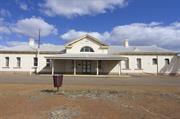
75 Woodward St Coolgardie
Museum
Railway Station (fmr)
Coolgardie
Goldfields
Constructed from 1896
| Type | Status | Date | Documents |
|---|---|---|---|
| State Register | Registered | 02 Sep 1997 | HCWebsite.Listing+ListingDocument, HCWebsite.Listing+ListingDocument |
| Type | Status | Date | Documents |
|---|---|---|---|
| (no listings) |
| Type | Status | Date | Grading/Management | |
|---|---|---|---|---|
| Category | ||||
| Classified by the National Trust | Classified | 27 Oct 1976 | ||
| Statewide Railway Heritage Surve | Completed | 01 Mar 1994 | ||
| Register of the National Estate | Permanent | 21 Mar 1978 | ||
| Municipal Inventory | Adopted | 27 Jul 1995 | Category 1 | |
| Name | Type | Year From | Year To |
|---|---|---|---|
| G T Poole | Architect | - | - |
| Library Id | Title | Medium | Year Of Publication |
|---|---|---|---|
| 4173 | Coolgardie Railway Station and Post Office Conservation Works 1998-Structure | Report | 1998 |
| 1354 | Coolgardie Railway Station and Goods Shed: Conservation Plan | Heritage Study {Cons'n Plan} | 1996 |
Individual Building or Group
| Epoch | General | Specific |
|---|---|---|
| Original Use | Transport\Communications | Rail: Other |
| Present Use | EDUCATIONAL | Museum |
| Original Use | Transport\Communications | Rail: Railway Station |
| Original Use | Transport\Communications | Rail: Housing or Quarters |
| Style |
|---|
| Federation Academic Classical |
| Federation Free Classical |
| Type | General | Specific |
|---|---|---|
| Roof | METAL | Corrugated Iron |
| Wall | BRICK | Painted Brick |
| General | Specific |
|---|---|
| TRANSPORT & COMMUNICATIONS | Rail & light rail transport |
This information is provided voluntarily as a public service. The information provided is made available in good faith and is derived from sources believed to be reliable and accurate. However, the information is provided solely on the basis that readers will be responsible for making their own assessment of the matters discussed herein and are advised to verify all relevant representations, statements and information.
Constructed from 1896
A good example of a substantial country railway station and goods shed complex. They are an integral part of this important complex of railway buildings in Coolgardie that were vital to the development and history of the Eastern Goldfields.
A stone and brick quoin station building with a hipped iron roof similar in design and detail to other railway stations of this period in the State. The facade is divided into 3 bays, the central bay with a pediment and arch and a hipped iron verandah over the entry. Later accretions have been arranged symmetrically . The goods shed is a simple timber framed iron cad industrial building with evidence of its earlier colour scheme of cream and deep indian red.
A building of substance, conforming to the character of railway buildings of the turn of the century and part of an important but now defunct communication and transport system for this isolated town. The station has many similarities to Bunbury Station.
Moderate-High
Good
| Name | Type | Year From | Year To |
|---|---|---|---|
| G T Poole | Architect | - | - |
| Ref ID No | Ref Name | Ref Source | Ref Date |
|---|---|---|---|
| Webb, M&A "The Centennial History of Kalgoorlie-Boulder" | 1993 |
| Owner | Category |
|---|---|
| Shire of Coolgardie | Local Gov't |
This information is provided voluntarily as a public service. The information provided is made available in good faith and is derived from sources believed to be reliable and accurate. However, the information is provided solely on the basis that readers will be responsible for making their own assessment of the matters discussed herein and are advised to verify all relevant representations, statements and information.
Coolgardie Railway Station and Goods Shed, comprising the stone and brick quoin walled and corrugated iron roofed railway station, the timber framed corrugated iron clad good shed, the timber framed corrugated iron motor shed and the timber framed corrugated iron electrical engineer’s office, has cultural heritage significance for the following reasons: the aesthetic value of the building in relation to their design and use of construction materials; the place contributes to the townscape as a significant component at a former point of entry and as a part of a precinct containing several important heritage places; the place has historic value as it was one of the two earliest government-built railway complexes in Western Australia. the place reflects the rapid growth of Coolgardie, following the discovery of the eastern goldfields, which created one of the most important goldrushes in the history of Australia; the place has association with an eminent Chief Architect from the Public Works Department, George Temple Poole, who was responsible for the design of a large number of public buildings in the state. The place is also associated with the State Engineer-in-Chief, C. Y. O’Connor, who was responsible for effecting the development of the goldfields through the establishment of a railway network and permanent water supply, as well as many other engineering achievements throughout Western Australia; the place demonstrates a simple elegance and grace, the Coolgardie Railway Station building as an interpretation of Federation Academic Classical and Federation Free Classical architecture, and the goods shed, simply as a very fine industrial structure that combines well with the remaining buildings on site that demonstrate the nature of a late 19th Century railway station complex; the place has social value for its role in the transportation of people and supplies, improvement in the living conditions and as a symbol of Coolgardie’s former prosperity contributing to the community’s sense of continuity of place as a museum; the buildings are of comparative rarity as they are amongst a small number of late 19th Century railway buildings to survive without being obscured by large scale change and redevelopment; and, the place is representative of major railway stations of the late 19th Century and is able to demonstrate, with the aid of interpretation, the manner in which a railway complex operated with a barracks accommodation and ancillary facilities, both within its contemporary curtilage and immediately beyond to the living accommodation that was build for the Resident Engineer, Station Master and platelayers. Aesthetic Value The group of buildings and intervening spaces comprising the remaining evidence of the Coolgardie station yard have a moderate degree of importance to the community for their aesthetic characteristics, more so as a formerly well composed set of places in an industrial setting than for their individual aesthetically pleasing characteristics. The two main structures, Coolgardie Railway Station and Goods Shed, are particularly important for their collective effect and their spatial relationship which reveals something of the functional and organisational nature of the site. Each building has its own distinctive aesthetical quality and, together, the group and its open spaces contribute to the community’s sense of history and place. The elevations of Coolgardie Railway Station are aesthetically pleasing and the simplicity of the design contributes to the charm and elegance of the building. The Goods Shed is an example of a once common type and has an elegant simplicity in its lines. Coolgardie Railway Station and Goods Shed contributes to the aesthetic values of the setting, by its landmark quality, as a former entry statement to the town. Coolgardie Railway Station and Goods Shed contributes to the aesthetic values of the setting as part of a precinct containing several important heritage places. Historic Value The construction of Coolgardie Railway Station building, together with the extension of the railway line from its previous terminus at Southern Cross in 1896, marked the beginning of the development and growth of communications and transport systems into the goldfields. It led to a large improvement in the quality of life for the people living in the goldfields. This also improved production with a flow-on effect which helped to underpin the economy of Western Australia. It also marked the beginning of the State Government’s involvement in the progressive extension of the north-eastern railway network. The completion of the railway had an impact on Coolgardie’s demographic growth, the development of the goldfields and subsequent increase in revenue for the state and the construction of permanent structures in the town of Coolgardie. Coolgardie Railway Station and Goods Shed is a reflection of the rapid growth of Coolgardie, following the discovery of the eastern goldfields, which created one of the most important goldrushes in the history of Australia, which substantially affected the development of the State of Western Australia and impacted on the economy of Australia. Coolgardie Railway Station and Goods Shed has association with an eminent architect Chief Architect from the Public Works Department, George Temple Poole, who was responsible for the design of a large number of public buildings in the state, many of which are heritage listed The place is also associated with the State Engineer-in-Chief, C.Y. O’Connor, who was responsible for effecting the development of the goldfields through the establishment of a railway network and permanent water supply, as well as many other engineering achievements throughout Western Australia. The opening of the railway was a significant state-wide event. The opening was attended by Governor Smith, the Premier, Sir John Forrest, members of cabinet and many other dignitaries. The buildings demonstrate a simple elegance and grace, the Coolgardie Railway Station building as an interpretation of Federation Academic Classical and Federation Free Classical architecture, and the goods shed, simply as a very fine industrial structure that combines well with the remaining buildings on site that demonstrate the nature of a late 19th Century railway station complex. Scientific Value As one of the state’s earlier railways and one to which so little has been added, the site has some scientific value in its potential to yield information on a late nineteenth century railway station complex. A wider understanding of the nature of a late nineteenth century railway complex would be available from this site through archaeological and further documentary research. The site has not been built over and much evidence remains of the locations of previous structures and the arrangement of the site. There is no evidence to suggest that there were any particular technical innovations in the construction of various elements on the site and the documentary evidence suggests that much of what was constructed was of a standard pattern. Social Value Coolgardie Railway Station and Goods Shed has social value for its role in the transportation of people and supplies to and from the town of Coolgardie to the western seaboard. The improvement of transportation dramatically improved living conditions for the people of Coolgardie and its surrounding districts, and, in more recent times, the community has claimed it as one of the symbols of Coolgardie’s former prosperity contributing to the community’s sense of continuity of place as a museum. Rarity Coolgardie Railway Station and Goods Shed are of comparative rarity as they are amongst a small number of late 19th Century railway buildings to survive without being obscured by large scale change and redevelopment. The remaining buildings and sites are evidence of a form of railway operation and railway workers’ existence that has long passed and provides evidence of the high status of the various levels of railway workers accommodation in relation to other housing in Coolgardie. Representativeness Coolgardie Railway Station and Goods Shed are representative of major railway stations of the late 19th Century, in spite of many adaptive changes to the buildings. The representative value, without interpretation or conservation, is reduced by the loss of the various outbuildings, fences and other site elements. The place occupies an important position in its capacity to demonstrate, with the aid of interpretaion, the manner in which a railway complex operated with a barracks accommodation and ancillary facilities. The surrounding quarters are an important integral part of the ability of the complex to demonstrate a wide range of station related activities. Condition Coolgardie Railway Station and Goods Shed is generally in poor condition. Detailed considerations of condition may be found in, Considine and Griffiths Architects: ‘Coolgardie Railway Station and Goods Shed, Conservation Plan’ (prepared for the Shire of Coolgardie, August 1996). Integrity Coolgardie Railway Station and Goods Shed has a moderate level of integrity. Its integrity geing diminished by the closure of the station and adaptation to a museum. For a discussion of the integrity of the place, refer to Considine and Griffiths Architects: ‘Coolgardie Railway Station and Goods Shed, Conservation Plan’ (prepared for the Shire of Coolgardie, August 1996). Authenticity Coolgardie Railway Station and Goods Shed has a high level of authenticity with great deal of original fabric existing in both structures, much of what is visible is authentic. For a discussion of the authenticity of the place, refer to Considine and Griffiths Architects: ‘Coolgardie Railway Station and Goods Shed, Conservation Plan’ (prepared for the Shire of Coolgardie, August 1996).
The Coolgardie Railway Station was completed at the same time as the railway line in 1896, as part of the contract for the Southern Cross to Coolgardie railway. The original plans were issued under the authority of the Chief Civil Engineer of Western Australian Railways, C.Y. O’Connor. The specification for the new railway station at Coolgardie is a useful reference and gives a clear picture of the structures to be provided in the initial construction campaign at Coolgardie. It also provides an invaluable source for referencing the nature of the original products and materials used in construction. The works included the construction of the station and platforms, picket fences, a goods shed, the outside loading platfom, a five tonne crane, station master’s house, wood sheds, latrines, two platelayers’ cottages, a 25,000 gallon water tank, an engine shed, two outside engine pits, carriage shed, coal store, turn-table, a sheep and cattle yard, carriage and horse loading platform, road approaches and footpaths. The station buildings were designed by George Temple Poole, of the Public Works Department, and the tender documents were issued by the Chief Engineer. The line and buildings were constructed by the Wilkie Brothers. Early drawings, figures 4 & 5, show the design of the station to be a simple classical composition with a long platform canopy and a short entrance canopy. Corners and openings have brick quoins and the walls are infilled with stone. Windows are arched head double hung sash and the roof is shown to be ventilated by gablets to both north and south elevations. The plan is based on a central ticket hall and office, with staff accommodation to the east of the hall and the passengers’ facilities to the west. A plan prepared for the Coolgardie water supply in 1905, locates all the station buildings elements, together with the two platelayers’ cottages (now private houses) and a station master’s house in Woodward Street, the goods shed at its original size, turn-table (demolished), the resident engineer’s house (now a private residence) and all ancillary buildings. An earlier plan, made in 1904, contains similar information and names all structures on the railway station site. By 1907, the production of gold had declined in Coolgardie and the fields to the east in Kalgoorlie and Boulder overshadowed Coolgardie with large and rich operations. The town began to lose its population to other centres and the suburbs and outlying areas were soon deserted. By the time of the First World War, the population was in steady decline and the war itself contributed to further decline. The station was under continual pressure for upgrading to meet the changes and growth of the railway system in its early days. Implementation of change was slow. The station’s visitors and occupants endur4ed uncomfortable conditions and patchwork attempts to improve them, if contemporary records are to be given full credit.
Constructed 1896 Coolgardie Station Building 1896-1933 The station building design was by George Temple Poole and the rooms of the building consisted of a public hall, ticket office, general waiting room, ladies’ waiting room, general purpose room, latrines and urinals, parcel room, station master’s office, a clerk’s office, a fuel room and a permanent way office. It is a single storey building 51 metres long by 6.4 metres wide in the main hall. The central foyer is 7.6 metres wide, with a portico to the north and platform with a 7.6 metre wide roofed area. The station building style lies somewhere between the Federation Academic Classical style and Federation Free Classical style. It has a pitched roof supported on timber trusses and corrugated iron cladding, with double hung sash windows positioned symmetrically, Ogee gutters are fixed along the eaves and round galvanised iron downpipes fitted off the gutters. Large fireplaces are in five rooms. The original concept remains legible, both in the elevation and plan with little major change to the original concept. The design was conceived as a major entry bay at the centre by wings to the east and west and two further lower wings added to the extreme ends of each of these. The verandah adds emphasis to the entrance at the centre of the building. No drawn documentary evidence is available to record the changes that occurred to the station until 1933, with the exception of a photograph indicating a second storey addition to the western-most room. This photograph is displayed in the station lobby at Coolgardie. The curiously designed addition has since been removed. 1933 Documentary evidence indicates that the Chief Civil Engineer commenced preparations to convert the general waiting room into a bedroom. It is evident that the seats which lined the west and east walls of the general reading room were removed for this purpose. Fly wire was nailed over several doors and windows of the room used for sleeping purposes; this is an intrusive element still evident today. 1939 Documentary evidence dating from 1939 suggests that the lamp room was converted into a bedroom. However, this indicates that the lamp room was far too small to accommodate a bedroom, the room was only 9 6’ x 8 ‘. It is far more likely that the clerk’s office adjacent to the station master’s office was altered instead, as later dated plans show this to be the case. 1942-1944 By 1942, several rooms had undergone conversions. The station building consisted of two bedrooms, one bedroom was the former clerk’s office adjacent to the station master’s office, the other ws the former general waiting room. No significant changes had been made structurally; the function was simply changed. Between 1942 and 1944, a kitchen had been placed in the former general purpose room and the fireplace in that room removed and replaced with a Metters stove. The ‘out-of-shed’ had taken the place of the former urinals. In the east wing the parcel and cloak room maintained its location, as did the station master’s room and the ladies’ waiting room. The water tanks had been removed and a file room was located where the fuel room used to be. The original lamp room appears to have been incorporated into the ‘out-of-shed’. One window in the ‘out-of-shed’ was blocked-up and a door and platform were added to the north wall. 1945 The existing ladies’ waiting room was converted into a bedroom and bathroom. The bedroom adjacent to the station master’s office was converted into a ladies’ waiting room and the Metters stove removed and converted into an open fireplace. A shower was installed into the lavatory and a sink installed in the room used as the kitchen. 1949 The station approach was resurfaced and white lines indicating 45 degree parking were placed on the bitumen which are still visible today. 1958 A separate barracks building was created in the former resident engineer’s quarters. The rooms previously used as bedrooms in the station building were converted into a ladies’ waiting room and new men’s conveniences. 1972 The last train left Coolgardie station on 28 November 1971. The line was officially closed on 16 September 1974. When the station building were taken over by the Shire of Coolgardie on 5 June converted into a museum, the limestone walls were painted white and two windows on the west side of the northern elevation were poorly filled-in. The present configuration of the building remains identical to its 1896 shape. The interiors were extensively remodelled to accommodate the changes over the years. The main walls of the existing station building were left in place to a large extent, but many of the spaces have been re-configured, in minor ways, for the change in purpose. The ‘out of shed’ has been converted into lavatories and partitions of lightweight construction divide the room into five separate compartments. The bathroom remains as was, the two bedrooms (original ladies’ waiting room and general waiting room) were converted into a flat for the caretaker. The former ladies’ waiting room now functions as a kitchen and an opening has been made in the east wall providing direct access to the original general waiting room which still functions as a bedroom. No changes have been made to the remaining rooms. All now functions as a bedroom. All now function as exhibition spaces with the exception of the two end rooms on the east wing which are used as a store room and workshop respectively. Refer to the drawings for descriptions of the present functions and parts of the place. Coolgardie Goods Shed 1896 The goods shed was a first class design, according to the specification. The goods shed is an industrial building form. Its walls were covered in corrugated galvanised iron. Girts are fixed horizontally to accept the iron cladding. The walls retain the original cladding system and colour scheme. The doors were made to roll aside, but only the southern doors remain in place. It had at least one office, judging from documentary evidence, of 2 x 3 inch timbers spaced and framed. The outside of this office was vertically boarded with 1 inch wrought, tongued and grooved boarding, according to the specification, but has since been removed. The interior of the office was lined and sealed with half inch wrought, tongued and grooved and beaded boarding. There is no evidence of the office in the building. Rainwater tanks were placed to each side of the shed; these have since been take down. The goods shed was originally 300 feet long. 1920s The foods shed was reduced in size. The office may have been removed at this time. It is uncertain what other modification were made in the process. The remaining shed, in its present format, does not comply with any standard pattern. Further, there is no evidence of a ridge vent system ever having been built. 1972 The good shed was taken over by the Shire of Coolgardie and now serves as part of one of the council depots. The changes are not substantial and allow the original concept and organisation to be read.
This information is provided voluntarily as a public service. The information provided is made available in good faith and is derived from sources believed to be reliable and accurate. However, the information is provided solely on the basis that readers will be responsible for making their own assessment of the matters discussed herein and are advised to verify all relevant representations, statements and information.
84 Woodward St Coolgardie
Coolgardie
Goldfields
Constructed from 1890
| Type | Status | Date | Documents |
|---|---|---|---|
| (no listings) |
| Type | Status | Date | Documents |
|---|---|---|---|
| (no listings) |
| Type | Status | Date | Grading/Management | |
|---|---|---|---|---|
| Category | ||||
| Municipal Inventory | Adopted | 27 Jul 1995 | Category 3 | |
Individual Building or Group
| Epoch | General | Specific |
|---|---|---|
| Original Use | Transport\Communications | Rail: Housing or Quarters |
| Present Use | RESIDENTIAL | Single storey residence |
| Type | General | Specific |
|---|---|---|
| Roof | METAL | Corrugated Iron |
| Wall | TIMBER | Weatherboard |
| General | Specific |
|---|---|
| DEMOGRAPHIC SETTLEMENT & MOBILITY | Settlements |
This information is provided voluntarily as a public service. The information provided is made available in good faith and is derived from sources believed to be reliable and accurate. However, the information is provided solely on the basis that readers will be responsible for making their own assessment of the matters discussed herein and are advised to verify all relevant representations, statements and information.
Constructed from 1890
A minor house that contributes to the railway station precinct.
A framed gable roofed cottage with a bull nosed verandah and lace added in recent times, with timber panelled front door and double hung sash windows flanking the front door.
A small intact dwelling that fits in with the railway station.
Moderate-High
Fair
| Owner | Category |
|---|---|
| Howells & Fitzgerald | Other Private |
This information is provided voluntarily as a public service. The information provided is made available in good faith and is derived from sources believed to be reliable and accurate. However, the information is provided solely on the basis that readers will be responsible for making their own assessment of the matters discussed herein and are advised to verify all relevant representations, statements and information.
Coolgardie - Norseman Coolgardie - Norseman
Dundas
Goldfields
| Type | Status | Date | Documents |
|---|---|---|---|
| (no listings) |
| Type | Status | Date | Documents |
|---|---|---|---|
| (no listings) |
| Type | Status | Date | Grading/Management | |
|---|---|---|---|---|
| Category | ||||
| Municipal Inventory | Adopted | 14 Aug 1995 | 5 | |
Historic Site
| Epoch | General | Specific |
|---|---|---|
| Original Use | Transport\Communications | Road: Other |
| Present Use | Transport\Communications | Road: Other |
| General | Specific |
|---|---|
| TRANSPORT & COMMUNICATIONS | Road transport |
This information is provided voluntarily as a public service. The information provided is made available in good faith and is derived from sources believed to be reliable and accurate. However, the information is provided solely on the basis that readers will be responsible for making their own assessment of the matters discussed herein and are advised to verify all relevant representations, statements and information.
Historic Value: This was the only track from Coolgardie to Norseman before the arrival of the railway in the early 1900's. Everything was transported along this route including, mail, food and mining supplies. Several people perished along this track during the summer months, when water in the soaks was scarce.
Bush track running parrallel to Coolgardie-Norseman Highway. Now abandoned.
Poor
This information is provided voluntarily as a public service. The information provided is made available in good faith and is derived from sources believed to be reliable and accurate. However, the information is provided solely on the basis that readers will be responsible for making their own assessment of the matters discussed herein and are advised to verify all relevant representations, statements and information.
Tindall's Dreadnought
Coolgardie
Goldfields
| Type | Status | Date | Documents |
|---|---|---|---|
| (no listings) |
| Type | Status | Date | Documents |
|---|---|---|---|
| (no listings) |
| Type | Status | Date | Grading/Management | |
|---|---|---|---|---|
| Category | ||||
| Municipal Inventory | Adopted | 27 Jul 1995 | Category 2 | |
Historic site
| Epoch | General | Specific |
|---|---|---|
| Original Use | MINING | Housing or Quarters |
| Present Use | MINING | Housing or Quarters |
| Type | General | Specific |
|---|---|---|
| Other | OTHER | Other Material |
| Other | METAL | Corrugated Iron |
| General | Specific |
|---|---|
| OCCUPATIONS | Mining {incl. mineral processing} |
This information is provided voluntarily as a public service. The information provided is made available in good faith and is derived from sources believed to be reliable and accurate. However, the information is provided solely on the basis that readers will be responsible for making their own assessment of the matters discussed herein and are advised to verify all relevant representations, statements and information.
A relatively intact example of a miner's camp that was in working use until the mid-1980's.
A compound containing a cottage with earth floors, bush furniture and considerable evidence of occupation. The compound contains a variety of structures including the remains of a shed with a forge base in it. The earth floors are of clay and at present contains a number of objects that are semi-submerged in the medium.
The compound is a demonstration of the hardship that prospectors were prepared to endure and of the resourcefulness of those forced to endure the harsh existence of marginal prospecting.
High
Fair
| Owner | Category |
|---|---|
| Goldfan NL | Other Private |
This information is provided voluntarily as a public service. The information provided is made available in good faith and is derived from sources believed to be reliable and accurate. However, the information is provided solely on the basis that readers will be responsible for making their own assessment of the matters discussed herein and are advised to verify all relevant representations, statements and information.
East Coolgardie
Coolgardie
Goldfields
| Type | Status | Date | Documents |
|---|---|---|---|
| (no listings) |
| Type | Status | Date | Documents |
|---|---|---|---|
| (no listings) |
| Type | Status | Date | Grading/Management | |
|---|---|---|---|---|
| Category | ||||
| Mining Heritage Study | Adopted | 30 Jun 1999 | ||
Historic Site
| Epoch | General | Specific |
|---|---|---|
| Original Use | MINING | Mining Battery |
| Present Use | MINING | Mining Battery |
This information is provided voluntarily as a public service. The information provided is made available in good faith and is derived from sources believed to be reliable and accurate. However, the information is provided solely on the basis that readers will be responsible for making their own assessment of the matters discussed herein and are advised to verify all relevant representations, statements and information.
East Coolgardie
Coolgardie
Goldfields
| Type | Status | Date | Documents |
|---|---|---|---|
| (no listings) |
| Type | Status | Date | Documents |
|---|---|---|---|
| (no listings) |
| Type | Status | Date | Grading/Management | |
|---|---|---|---|---|
| Category | ||||
| Mining Heritage Study | Adopted | 30 Jun 1999 | ||
Historic Site
| Epoch | General | Specific |
|---|---|---|
| Present Use | MINING | Mining Battery |
| Original Use | MINING | Mining Battery |
This information is provided voluntarily as a public service. The information provided is made available in good faith and is derived from sources believed to be reliable and accurate. However, the information is provided solely on the basis that readers will be responsible for making their own assessment of the matters discussed herein and are advised to verify all relevant representations, statements and information.