Local Government
West Arthur
Region
Wheatbelt
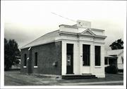
29 Burrowes St Darkan
Lot 23
Agricultural Protection Board
West Arthur Roads Board
West Arthur
Wheatbelt
Constructed from 1929
| Type | Status | Date | Documents |
|---|---|---|---|
| (no listings) |
| Type | Status | Date | Documents |
|---|---|---|---|
| (no listings) |
| Type | Status | Date | Grading/Management | |
|---|---|---|---|---|
| Category | ||||
| Classified by the National Trust | Classified | 08 May 2000 | ||
| Municipal Inventory | Adopted | 27 Mar 1997 | Category 2 | |
Individual Building or Group
| Epoch | General | Specific |
|---|---|---|
| Present Use | GOVERNMENTAL | Office or Administration Bldg |
| Original Use | Transport\Communications | Road: Office or Administration Bldg |
| Style |
|---|
| Federation Free Style |
| Type | General | Specific |
|---|---|---|
| Roof | METAL | Corrugated Iron |
| Wall | BRICK | Common Brick |
| General | Specific |
|---|---|
| TRANSPORT & COMMUNICATIONS | Road transport |
This information is provided voluntarily as a public service. The information provided is made available in good faith and is derived from sources believed to be reliable and accurate. However, the information is provided solely on the basis that readers will be responsible for making their own assessment of the matters discussed herein and are advised to verify all relevant representations, statements and information.