

Local Government
Victoria Park
Region
Metropolitan

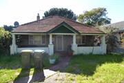
2 Mars St Carlisle
Victoria Park
Metropolitan
Constructed from 1950
| Type | Status | Date | Documents | More information |
|---|---|---|---|---|
| (no listings) |
| Type | Status | Date | Documents |
|---|---|---|---|
| RHP - Does not warrant assessment | Current | 25 Oct 2019 |
| Type | Status | Date | Grading/Management | More information | |
|---|---|---|---|---|---|
| Category | Description | ||||
| (no listings) |
|
||||
The place is a modest example of a single storey residence erected during the post-WWII period.
The place is one of a small number of places known to have been constructed using hand-made concrete blocks.
P26284 House 2 Mars Street, Carlisle is a single-story concrete block and tile house comprising two bedrooms, kitchen, lounge, bathroom, front and rear verandah, and detached laundry/toilet, located on a corner position on the north eastern side of the street at the intersection of Roberts Road. The residence is set back from the street boundary, which has been enclosed by low concrete block with red brick capping boundary wall to Mars Street and part of the Roberts Street boundary position on the north eastern side of the street, at its intersection with Roberts Road.
Internally, the property is of simple plan form. The central entrance leads into a hallway which
provides access to rooms on either side and terminates at the kitchen. The finishes include plastered and painted walls and ceilings throughout with timber/linoleum floors with in the kitchen, timber/carpet floors in the lounge and bedrooms, linoleum floors in the bathroom, and timber floors in the hallway. Notable interior elements include art deco-style ceiling roses in the bedrooms and lounge, painted brick fireplace in the lounge, and a ‘Metters New Improved Stove No. 1’ housed in a brick surround in the kitchen.
In 1897, a plan was approved by the Department of Lands and Surveys (now Landgate) for a large portion of land in Victoria Park which includes the subject place. The subdivision, advertised as Bickford Park, accentuated its proximity to the new railway line.
Throughout the early twentieth century, a large proportion of housing development in the area was attributed to the government policy of providing affordable housing in the State, administered by the Workers Homes Board.
In 1919, a meeting of ratepayers elected to change the name to name 'Carlisle' and the suburb was slowly settled.
In the period following WWII, there was rapid settlement of the regions bordering central Perth, including Victoria Park, resulting from the government policy of providing incentivised residential housing to displaced service-personnel following WWII administered by the State Housing Commission.
Individual Building or Group
This information is provided voluntarily as a public service. The information provided is made available in good faith and is derived from sources believed to be reliable and accurate. However, the information is provided solely on the basis that readers will be responsible for making their own assessment of the matters discussed herein and are advised to verify all relevant representations, statements and information.