Local Government
Wanneroo
Region
Metropolitan
Star Swamp to Allanooka
We are currently experiencing technical issues with mapping updates and some errors may be displaying. Please contact the Department if you have any questions. The entire route ran from Star Swamp to Allanooka. The place has been mapped based on information from plans showing the originally gazetted stock route in the 1890's, and the current cadastre. The curtilage also includes relevant reserves set aside along the route for watering stock and resting.
Champion Bay Stock Route
North West Stock Route
Old North Rd
Old North Stock Route
Wanneroo
Metropolitan
| Type | Status | Date | Documents | More information |
|---|---|---|---|---|
| (no listings) |
| Type | Status | Date | Documents |
|---|---|---|---|
| RHP - Minister did not direct Registration | Current | 16 Oct 2024 |
| Type | Status | Date | Grading/Management | More information | |
|---|---|---|---|---|---|
| Category | Description | ||||
| (no listings) |
|
||||
Old North Road Stock Route is a stock route in use from the 1850s and formally defined by survey in 1889, following much of the original Old North Road to Geraldton, which extends from Star Swamp, North Beach to Allanooka Swamp, Allanooka (54km south east of Geraldton), and comprises sections of the former route, including a series of wells, homesteads, natural water bodies, resting points, bridges and crossing points that has cultural heritage significance for the following reasons:
- the place, in directly facilitating the development of settlement and farming, disrupted the lives of the Amangu Yamatji, Yued Noongar and Whadjuk Noongar people who occupied the lands that the route passed over for at least 40,000 years. Culturally significant sites in the form of water sources along the route that are associated with the Wagyl (Noongar) and Bimara (Yamatji), or rainbow serpent, were directly impacted which resulted in profound emotional and spiritual disturbance;
being one of the oldest stock routes in the State and the axis of many stock routes leading northwards, the place, was instrumental in opening up and sustaining the development of the nearer northern districts for pastoralism in the 1850s, and later forming part of the main route for travellers, mail carriers and drovers before the Midland Railway was completed in 1894;
- the place demonstrates the transition of Aboriginal water sources and pathways through the landscape to Colonial use through the explorations and actions of colonists and drovers using the route;
the place is a physical reminder of the incredible difficulties encountered in droving stock through uncleared land over long distances in the nineteenth century and has the archaeological potential to shed light on the lives and activities of early drovers, travellers and those who settled along the route;
- the place is associated with a number of prominent and influential figures including pastoralist, merchant and philanthropist, Walter Padbury, who was responsible for establishing the more-direct alignment of the route in 1855; Assistant Surveyor Augustus Gregory, who surveyed the initial road north on which the later stock route was based; and pastoralist and politician, Edward Hamersley, who had substantial land holdings and developed industry along the route;
the place is characterised by its path through the changing landscape of vast sandplains, deep limestone gullies and unexpected swamps and waterholes, which contribute to understanding the ambitious and impressive nature of the journey taken along the route;
- the place is representative of the many stock routes established throughout Western Australia in the mid to late 1880s and early 1900s;
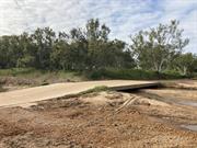
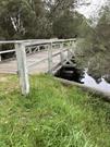
- the place includes Old Junction Bridge, the oldest timber bridge still in use in the State.
Roadways, particularly running perpendicular to the stock route, and modern residential properties within the curtilage of the place are intrusive.
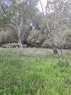
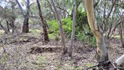
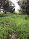
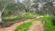
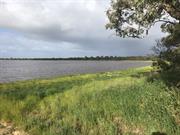
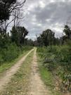
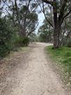
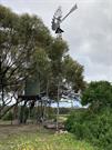
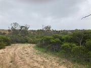
Extending from Star Swamp in North Beach to Allanooka Swamp in Allanooka, the Old North Road Stock Route is approximately 335 kilometres, running through varying landscapes and including different features and stopping points along the way. The route within the landscape is largely contiguous, predominantly demarcated as Reserve tenure, however also passing through farmland areas and following some roads. There are no clear examples of the former stock route track, however the track has formed the basis of some fire break and 4WD tracks that follow the route.
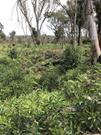
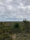
The southern portion of the route extending from North Beach to Yanchep formally ran through, what is now, a highly residential area, however the stock route is visible in the landscape in the form of a number of reserves comprised of native bushland. These reserves form a discontiguous portion of the route, as the residential areas are not included due to the lack of intact fabric. Soils are relatively sandy in these areas and vegetation comprises banksias and low-lying heath.
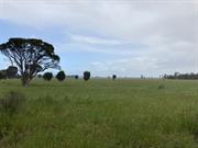
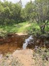
Moving north from Yanchep, the route passes through semi-rural areas, which includes State Forest, Crown Reserve and Freehold areas. Vegetation stays much the same until reaching Neergabby and Cowalla where richer soils surrounding the waterways become evident. Much of the route leading to and from Cowalla runs over privately-owned farmland as well as designated stock route reserves which comprise sandy soils, banksias and low-lying heath similar to the southern end of the route. The route forks before reaching Cowalla, indicating the summer and winter route that were taken due to flooding in the winter months. It joins up again at Nine Mile Swamp, which is characterised by fine clay soils.
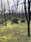
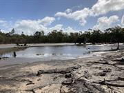
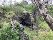
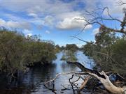
Vegetation changes as the route nears Nambung National Park to include large tuart trees and dense scrub. Leading from Nambung up through Cockleshell Gully, Diamond of the Desert, Little Three Springs and Stockyard Gully the landscape is characterised by an extensive interconnected limestone cave system that provides natural springs resulting in sheltered areas that were used as watering and resting points along the route. The flat, sandplain areas in between these features create a sense of vastness and isolation.
The limestone and sandy soil continues further north, reaching the Lake Logue – Lake Indoon system of wetlands and clay-pan lakes. This area provides various watering points along the route and was initially identified by Gregory’s exploration party as promising grazing lands in 1848. The landscape in these areas largely becomes drier as it crosses the sandplain. ‘On reaching the Irwin River it drops down through openings in the low breakaways at the Yardarino and Milo crossings. The northern section of the route crossed the alluvial river valley and a braid of old billabongs and river flats around ‘Irwin House’ and the former Yardarino Common, and then rose from the river valley through undulating low breakaways and sandplains of the Victoria Range about 100-150 metres above sea level until finally reaching the great Allanooka springs and wetlands in a deep basin in the breakaways easterly of Mt Hill’.
The sandplain region that surrounds Dongara and Port Denison that includes much of the stock route leading south is internationally recognised as a biological hotspot, with ‘nearly half of the plant species that grow [there]’ not found anywhere else in the world. Portions of the place where land tenure is designated as ‘stock route’ continue to support such rich communities of vegetation.
The route from Perth to Champion Bay, now Geraldton, passes through the tribal lands of the Whadjuk Noongar people, the Yued Noongar people and the Amangu Yamatji people, also known as the Wilinyu.
The intimate knowledge of water sources within the landscape was hugely beneficial in 1839, when Aboriginal groups came into contact with a group of 12 shipwrecked explorers, who were the first Europeans to travel the 300 miles (480 kilometres) from the Greenough Flats and Champion Bay (now Geraldton) region to the Swan River. The expedition, led by Lieutenant George Grey, an army officer of the 63rd Regiment, was encouraged by the Royal Geographical Society to study the fauna, flora and geology between Northwest Cape and Gantheaume Bay. After being dropped on Bernier Island north of Shark Bay on 25 February, the expedition gradually lost all of its boats and most of its supplies and equipment. The party was forced to walk 550 kilometres to Perth and fortunately met a local group of Aboriginal people, who assisted the men and guided them through Aboriginal pathways in the bush. On the journey, Grey observed the huts constructed by local people and commented in certain areas that they held over 150 people, indicating the large populations of Aboriginal people in the area.
The route taken by Grey and marked on cartographer John Arrowsmith’s 1841 map of the South-west Australia was to become, with only minor alteration, the road between Perth and Champion Bay.
In September 1848, Assistant Surveyor Augustus Gregory, led a ‘Settlers Expedition’ as far north as the Murchison River with the primary goal of finding new grazing pasture but to also watch for useful minerals, take note of plants and animals and observe the character and customs of local Aboriginal people.
While 46 tons of equipment was sent north on the government schooner, Champion, another party led by Augustus Gregory and his Aboriginal interpreter Kardakai (Cardagyt), travelled overland with men, horses and carts. This was the first journey that was a commercial venture rather than pure exploration. Gregory was given explicit instructions from the Surveyor General on behalf of the Governor to choose and blaze his own route north to Champion Bay using horse and cart, pick the best road to the mine and help choose a suitable boat harbour and road to it.
E. G. Hester was the first of the party accompanying Gregory to return overland to Perth. He travelled back alone and took a more direct, easier route than that previously taken. This easier route approximated very closely to what would become the later official road and eventually the Old North Road Stock Route. A month later Gregory also followed this second route on his way to Gingin and described it as being ‘better suited for a line of communication as regards water, grass and a freedom from rocky ground or dense scrubs than any of my former routes’.
Developments and deviations of the road north to Geraldton (and what was to become the Old North Road Stock Route) continued over time for practical reasons. Commonly known as the North Road or the Coast Road, the Perth to Champion Bay Road was formally gazetted in May 1862 and followed the line blazed by Padbury as far as Neergabby in 1855 and the 1859 extension to Hill River. The road became the mainstay for the coastal areas between Perth and Dongara and was used by increasing numbers of travellers and drovers of livestock. Not only did drovers use the route but also families, government officials, high dignitaries from overseas and anyone travelling from the two regions.
In 1889, the Stock Route was formally established, with the reservation of land for the convenience of travelling stock and their drovers. Watering stops and reserves were plentiful and strategically placed along the route for travelling stock.
In addition to travellers and drovers, the Old North Road Stock Route was also used by the overland mail service to Champion Bay and kangaroo hunting parties who camped at the swamps and waterholes along the way. The mail route was firmly established by 1853 and didn’t alter for many years.
By the mid-1860s an alternative route north started to develop parallel and to the east of the stock route. Settlers began establishing permanent homesteads within reasonable distance to each other from Watheroo, through Carnamah and Arrino up to the Irwin River. By taking this route travellers could rest at the various homesteads after a day or two, making it an attractive option for travellers to take.
The Wanneroo Roads Board made a recommendation to the Secretary of Lands on 14 March 1928 for the closure of the ‘old coast stock route’, referred to as ‘Reserve 1556’. However, the Gingin Roads Board, Mingenew Roads Board and Dandaragan Roads Board all objected, stating that the route was still in use in their respective districts.
Prior to World War II, summer holiday makers also used the Old North Road Stock Route during the summer months, as favourite camping spots at the many protected bays between Yanchep and Dongara were accessed by bush tracks from the old Stock Route. Regular use of the Old North Road Stock Route was briefly revived in 1942 when it was used by the Army to patrol for possible enemy landing places up the coast.
As part of the bicentennial celebrations in 1988, the City of Wanneroo and Daphne Gratte organised a group of around 120 participants to re-enact the movement of stock on the Old North Road Stock Route (430 kilometres from Geraldton to Wanneroo).
North West Stock Route (fmr) Stage 1, was added to the Register in June 2002 and at that time it was resolved that the remainder of the route would be assessed for the Register at a later date.
At the time it was assessed, residents of Gingin/Neergabby had formulated a proposed bridle/walk trail following the route of North West Stock Route (fmr) Stage 1 through Yanchep National Park to Neergabby. This proposal was under consideration by land owners and stakeholders, but appears to not have eventuated. In 2008, a drive trail following the route within the Shire of Gingin was established.
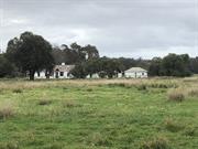
In 2021, the route is recognised in areas as designated stock route reserve or as reserve set aside for the protection of flora and fauna. Cowalla, Fatfield, Allanooka Inn and Junction Hotel have all been restored and used as private residences. Natural features, including Lake Logue, Stockman’s Gully Cave, Lake Indoon and Nambung Pools are tourist attractions within the region, with varying levels of recognition as features along the Old North Road Stock Route.
| Library Id | Title | Medium | Year Of Publication |
|---|---|---|---|
| 12335 | Old North Road Stock Route - concept plan | Other | 2002 |
Landscape
| Epoch | General | Specific |
|---|---|---|
| Original Use | FARMING\PASTORAL | Other |
| Present Use | OTHER | Other |
| General | Specific |
|---|---|
| DEMOGRAPHIC SETTLEMENT & MOBILITY | Aboriginal Occupation |
| OCCUPATIONS | Grazing, pastoralism & dairying |
| DEMOGRAPHIC SETTLEMENT & MOBILITY | Exploration & surveying |
| PEOPLE | Local heroes & battlers |
| TRANSPORT & COMMUNICATIONS | Droving |
This information is provided voluntarily as a public service. The information provided is made available in good faith and is derived from sources believed to be reliable and accurate. However, the information is provided solely on the basis that readers will be responsible for making their own assessment of the matters discussed herein and are advised to verify all relevant representations, statements and information.