Local Government
Cue
Region
Midwest
Cue
Lot 86 on DP 187742
Cue
Midwest
Constructed from 1930 to 1970
| Type | Status | Date | Documents | More information |
|---|---|---|---|---|
| (no listings) |
| Type | Status | Date | Documents |
|---|---|---|---|
| RHP - Does not warrant assessment | Current | 11 Sep 2024 |
| Type | Status | Date | Grading/Management | More information | |
|---|---|---|---|---|---|
| Category | Description | ||||
| (no listings) |
|
||||
The place has historic value for its association with the development of the Murchison goldfields, particularly linked to the post-boom period of mining, and is likely associated with the former Day Dawn townsite.
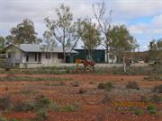
The place is a complex of buildings thought to be remnants of a former miner’s homestead. The main residence is clad with asbestos sheeting and appears to have a corrugated iron roof, and comprises three bedrooms, a living area, kitchen, and bathroom. Other structures within the complex include two tool sheds, a generator shed, windmill, water storage tank and stand.
It is not known exactly when Aboriginal groups arrived in the Mid West region of Western Australia. Excavations of Yalibirri Mindi Rock shelter at the Weld Ranges indicate an ongoing physical and cultural presence for at least 30,000 years. The Aboriginal people of this region are currently known as the Wajarri Yamatji. A particular cultural feature of the Wajarri people has been the trade of red ochre mined in the Weld Ranges, particularly from Wilgie Mia and Little Wilgie Ochre Mine. The former has been used by both Wajarri (Aboriginal) and non-Aboriginal people for the purpose of extracting red ochre.
The first gold claim on the Murchison occurred in 1890, approximately 65 kilometres northeast of Cue, on land which was later established as the Nannine townsite. The Murchison Goldfield was proclaimed on 24 September 1891. Some of the mining centres within the field include Cue, Day Dawn, Lake Austin (the Mainland and Island), Cuddingwarra, Nannine, Mount Magnet, Meekatharra, Big Bell, and Tuckanarra. These mine sites began with a brief period of alluvial mining followed by large scale reef mining, of which some remain active today. Many of these mining fields, and associated townsites that developed, were later abandoned.
Brega Wells, Cue is approximately 1.5 kilometres south-east from the former Day Dawn townsite. Gold was discovered in the area in 1891. A new settlement sprung up, originally known as the ‘Four Mile’, named after its distance from Cue. A townsite was gazetted in March 1894 first as ‘Bundawadra’, later renamed as Day Dawn in May 1894. By 1896, approximately 200 men were employed at the associated mine, and the townsite included three stores and a chemist, three licensed houses, a few dwelling houses, hessian camps, and brush humpies. The mine’s success contributed to the extension of railway facilities to the region in 1897. The following year, the mine was taken over by the Great Fingall Consolidated Gold Mining Company and was thereafter known as the Great Fingall Mine. The Great Fingall Mine closed in April 1918 and by October 1921, the abandoned mine had completely collapsed. The townsite was deserted by the 1930s. In the mid-1990s, the Great Fingall Mine was reopened as an open cut operation and in 2023 the mine became part of the Westgold Resources Cue gold operation.
There is little documentary evidence specific to Brega Wells, Cue. A letter from the Department of Land Administration to the Director General of Mines in 1987 indicates the place was a miner’s homestead before being leased for the purpose of ‘residence and cultivation’. At this stage, the place was named ‘Kyarra Location 86’, and was previously ‘Garden Area 22’. The lot is marked in a reconnaissance structural map of the district dated c.1950, labelled ‘GA 22’ which presumably relates to the previously mentioned name. The structures potentially date from this time. There has been no change in the site layout since 2014, which is the earliest available aerial photography covering Brega Wells, Cue.
While not confirmed, the current name ‘Brega Wells’ may derive from the Brega family. Enrico Brega was an Italian prospector who lived at Day Dawn with his wife Flora. A mining tenement cancellation for Flora Brega within Garden Area 22D at the Day Dawn district was published in 1969, suggesting the family occupied the place at a point in time, and held a mining lease.
It has also been suggested Brega Wells, Cue is the location of one of three slaughterhouse sites in Cue. The concrete pad within the site is reportedly the foundations of the former slaughterhouse however, there is little documentary evidence to confirm this.
As of 2024, the place is leased as a residence. There is a mining tenement to Westgold over Brega Wells, Cue that also encapsulates the surrounding Day Dawn mining area.
Historic site
| Epoch | General | Specific |
|---|---|---|
| Original Use | RESIDENTIAL | Other |
| Type | General | Specific |
|---|---|---|
| Other | ASBESTOS | Other Asbestos |
| General | Specific |
|---|---|
| Economy | Mining and Mineral Resources |
This information is provided voluntarily as a public service. The information provided is made available in good faith and is derived from sources believed to be reliable and accurate. However, the information is provided solely on the basis that readers will be responsible for making their own assessment of the matters discussed herein and are advised to verify all relevant representations, statements and information.