

Local Government
Swan
Region
Metropolitan

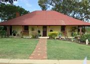
9810 West Swan Rd Henley Brook
Municipal Inventory No: 504
Clearwell; Richard Edward's House
Swan
Metropolitan
Constructed from 1830, Constructed from 1850
| Type | Status | Date | Documents | More information |
|---|---|---|---|---|
| Heritage List | Adopted | 30 Aug 2017 | ||
| Heritage List | Adopted | 08 Apr 2026 | ||
| Heritage List | YES | 15 Dec 2010 | ||
| State Register | Registered | 19 Mar 2004 |
Register Entry Assessment Documentation |
Heritage Council |
| Type | Status | Date | Documents |
|---|---|---|---|
| (no listings) |
| Type | Status | Date | Grading/Management | More information | |
|---|---|---|---|---|---|
| Category | Description | ||||
| Municipal Inventory | Adopted | 25 Jun 1997 | Exceptional Significance |
Exceptional Significance |
|
| Classified by the National Trust | Recorded | 17 Jan 1977 |
|
Heritage Council | |
The Archaeological Sites provide physical evidence of the earliest period of European agricultural development in Western Australia, as it is part of a portion of Swan Location E1, one of the first rural grants made in the Swan River Colony;
The house is a simply designed, well proportioned single storey adobé and corrugated iron roof construction in the Victorian Georgian vernacular style set in a culturally modified riverside setting; and
The place was owned by what were regarded as, in the nineteenth century, a labouring family, who became successful landowners in the Swan District.
The modern 1970s residence located to the north of the c.1850 house, sheds located to the south of it, fences, miniature bridge, paving surfaces, arbors, and recent plantings, have little cultural heritage significance.
Edwards’ House and Archaeological Sites is a single storey adobé and corrugated iron roof construction Victorian Georgian vernacular style house built in c.1850, with archaeological sites dating from c.1830. It is located in a culturally modified riverside landscape setting, sited on a bank high above the Swan River.
Edwards’ House, is located some 100 metres east of West Swan Road and about 45 metres from the Swan River. The elevated location allows views through the tree line to the river and to the Darling Escarpment beyond. Other built site features include a modern bungalow style residence (north of the house); metal framed and clad sheds (south-west of the house), arbors, a miniature bridge, roads, and fences. Archaeological features noted in the documentary evidence include sections of an old road (north, north-west of the modern residence), the remains of an early house (north of the house), evidence of a garden on the river plane (east of the house), and a medium density artefactual scatter below the house. None of these features is readily apparent. An ironstone formation near the river adjacent to the northern boundary can be seen, but it is not clear what purpose this formation might have served.
Edwards’ House is a single storey adobé and corrugated iron roof construction Victorian Georgian vernacular style house, with a series of subsequent alterations and additions. The original house walls are made of large mud blocks that appear to be founded on a concrete or thick render plinth about one block high. The openings in all cases appear to be treated with replacement material including spiral wound double hung sashes, glazed double doors and panel and glazed doors. There are timber lintels over openings, with header courses of brick laid on top of the timber. The verandah that extends around the house has a concrete floor and the posts that support the verandah are a mixture of stop chamfered posts, and much later sawn timber posts. The roof is a hip roof with a broken back over the verandah and is clad with painted galvanized corrugated iron and rolled ridges. The gutters are recently installed colonial profile Colorbond gutters.
Two brick construction flues extend through the roof and a solar hot water panel is located on the north roof slope. On the north-east corner, and for most of the northern side of the verandah, a framed and asbestos cement infill provides laundry and bathroom accommodation. It is understood that the northern verandah was completely enclosed at one period and that the current laundry and bathroom are all that remain of this construction. Key changes to the exterior include the concrete to the verandah, painting over the adobé walls, replacement joinery of all openings, and the replacement of the gutters with a Colonial profile.
Edwards’ House and Archaeological Sites is a single storey adobé residence with an iron roof, in the Victorian Georgian vernacular style, with archaeological sites dating from c.1830. The house was built by members of Richard Edwards’ family as the Edwards’ family residence in c.1850.
In late September 1829, Captain Stirling and Surveyor General Roe travelled to the head of the Swan River above Guildford with a group of European settlers to whom permission had been given to select land. These were the first rural grants in the Colony. Most of those who obtained these grants were notable men in the young Colony, whilst a few were wealthy absentee investors. Swan Location E, 4,696 acres in area, was granted to Lionel Samson, which he named Clearwell. It extended from the Swan River through Lake Goolelal to the Coast.
Most of the original grants, known as ‘ribbon grants’ from their elongated form, were between 6 and 18 miles long, running from the fertile alluvial land by the river. In 1829, carving incisions on trees at the riverbank marked the boundaries of the grants. No complete survey of the grants along the Swan and Helena Rivers was undertaken until the early 1840s. The grantees were required to fulfil location duties requiring the expenditure of 1s 6d on permanent improvements to the satisfaction of the Government before receiving freehold title to their grants.
From 1830-31, a number of the original 1829 rural land grants were transferred to other European settlers.
By 1835, Richard Edwards (b. 1876, arr. per Hooghly February 1830) was performing the location duties on Samson’s Swan Location E. An energetic and hard-working brickmaker, Edwards had brought with him to the Swan River Colony his wife, Elizabeth (b. 1782), and his family, including his younger sons, Richard (b. 1806), George (b. 1807), Samuel (b. 1817?), Joshua (b. 1820) and Matthew (b. 1826), and his daughter, Dinah (b. 1818), under Peel’s scheme. The Peel Association, led by Thomas Peel, nephew of the then home secretary, was organised by four wealthy men and involved bringing capital and settlers to the Swan River Colony in exchange for large land grants. At Clarence, a number of the steerage passengers built themselves ‘very comfortable cottages’, ‘by far the best one in the place’ being that built by Richard Edwards and his sons ‘all industrious like himself’. When Peel’s scheme failed due to some poor land selections and a lack of knowledge of the conditions of the Swan River Colony, Richard Edwards had obtained work with Captain Irwin on the grant he held with W. H. Mackie at Henley Park, which adjoined Samson’s grant. Richard Edwards’ sons assisted him in his endeavours, and became ‘active partners’ in his building activities.
From 1830 to 1837, Richard Edwards was employed as manager at Henley Park, where he built a two storey house for Irwin, utilising his skills as a brick-maker. On completion, it was reputed to be the finest in the Colony at that period. Also, he built a two storey house for Lt. Henry Bull at George Leake’s grant, and a three room brick cottage for William Haddrill. In 1835, Irwin described Richard Edwards as “a man of intelligence and observations” who was “indefatigable in his labours”, and praised his achievements in gardening, especially his irrigation of the land; whilst Elizabeth Edwards was described as “a regular dairy woman”.
In 1837, in the Swan district, nine heads of households were described as agricultural labourers, among them Richard Edwards. By this period, Richard Edwards had built his own family home at the property. It was of brick construction, as shown on a later plan (1841).
On 8 April 1839, a Deed of Conveyance was registered whereby 2,339 acres of land at Swan Location E was transferred from Lionel Samson to Richard Edwards. Edwards grant was designated Swan Location E1.
In 1841, Chauncy surveyed the Swan grants and the boundaries were revised as required. At Richard Edwards’ property, there were three buildings by this period, one of brick, being the Edwards’ home, and two timber farm buildings. The garden is also shown by the river, and the quarry, which Richard Edwards used to obtain clay for his brick-making, north of the house, farther towards Henley Park.
On 6 February 1850, The Inquirer reported:
Fire broke out on Sunday last, on the premises of Mr. Edwards, of the Upper Swan, which, we regret to state, effected the thorough destruction of his house and out-buildings, and extending to Colonel Irwin’s, destroyed the whole of his stacks, barns, granaries, and in fact, every building, except his dwelling house.
On 19 March 1850, Richard Edwards died at age 73, and was buried at All Saints. He bequeathed his property at Gingin to his three sons, Samuel, Matthew and Joshua, and the property at Swan to his wife until her death, when it was to be divided between his sons. With their building skills and ready supplies of materials, the Edwards family would not have wasted much time before building the new house at Clearwell. It is not known whether it was completed before or after Richard’s death. The new home site for Edwards’ House was about 80-90 metres south of the earlier home-site. Constructed of adobé, the four room house was well located above the river flats, and convenient to the natural spring from which the name of the property was derived.
Elizabeth Edwards continued to live at Edwards’ House until her death in April 1866. Whilst some of Richard Edwards’ sons continued to work the property at Gingin, Samuel Edwards and other members of the family continued to live at Edwards’ House and to work Clearwell. In February 1853, Samuel married Charlotte Broom. Samuel Edwards continued to live and work at the place until March 1884, when the property, comprising 895 acres, was transferred to Edward Ralph Brockman, farmer and grazier, of Henley Park.
In June 1896, portion of Swan Location E1 was transferred to Henry John Saunders, of Perth. On 13 October 1919, Henry John Saunders died, and Probate of his Will was granted to one of the executors named therein, Cecil Henry Forrest Saunders, woolclasser, of Perth, on 4 December 1919.
An undated photograph (est. date 1920) shows Edwards’ House when the adobé walls were un-painted. At one side, there is an iron addition that in- fills the side verandah, with a small upper window on one side and a metal chimney stack, suggesting this was the bathroom and laundry at that period, as does the water tank set near by. The house is fenced around at a short distance from the verandah by a timber post and barbed wire fence, with a single timber gate aligned with the entry to the house.
In August 1975, the place was transferred to John Dennis Beach, farmer, and his wife, Esma Margaret Beach, of 161 West Road Bassendean. They found Edwards’ House in poor condition internally. There were doors missing and the place appeared to either have been used for stabling horses, or simply left open to the stock. The Beachs set about making the cottage habitable and undertook the necessary repairs and maintenance. Where necessary doors and windows were replaced, new double doors were fitted to one of the rear rooms, a new window opening cut through at the front to provide more light, a rain water tank was set up by the laundry to provide fresh water for house, the interior and exterior of the place was painted, and a fence erected. On completion of these works, the Beach family took up residence at the place, and lived there until their new house was completed on a site to the north-west (in the vicinity of the buildings that were destroyed in the 1850 bush fire). The new house was built to the same plan as the Beach’s former home at 161 West Road, Bassendean. On completion, the family took up residence in their new home. A well was sunk on the lower ground to provide water that was pumped up to the garden. Subsequently, the original house was occupied at various periods by members of their extended family and/or friends, including a keen gardener who established a good garden.
In 1978, a photograph shows the place fenced around by a low open white painted fence, the roof un-painted with two sky-lights in the front verandah roof to allow more light through the windows of the two western rooms. There is a tall metal tank stand and water tank at the north side of the house. There is a road way between the house fence and the fence to the paddock at the west.
In 1978-79, applications were made to sub-divide the property.
In 1991, when Philip Beach married, he was given the lot of land at the north-west. Philip lived at Edwards’ House and Archaeological Sites for about three to four years, during which the kitchen was renovated. After he moved, the place was let to tenants.
Esma Beach applied to further sub-divide the property, but the application was refused. As she and John were advancing in years, it was too large for them to continue to manage. In May 1997, it was sold, to Arthur Patrick Thain and Roberta Joyce Thain, of 2 Morris Road, Innaloo, for the sum of $730,000, and the property was further reduced to 6.2376 ha. in area.
On 25 June 1997, the place was included in the Municipal Heritage Inventory for the Shire of Swan and recommended for entry in the State Register of Heritage Places.
The Thains named the property ‘Arum Lily Farm’ as arum lilies grow in profusion on the river flats. They operated the place as a licensed bed and breakfast establishment, with facilities available for weddings and other functions. Edwards’ House had ‘a cosmetic make-over’: vinyl floor coverings were lifted in some rooms, revealing original timber floor boards, which were replaced as necessary with matching salvaged boards, the exterior was spray painted, guttering replaced and the roof painted red, and the house fitted out to serve as self-contained accommodation. A name-plate was fixed on the gate ‘Richard Edwards’ House, Circa 1847’. A paved driveway linked it to the newer house. Brick paving was laid at the rear and the south side to provide outdoor living areas. Extensive formal gardens were laid out over 0.8 ha. of the property, including 300 roses and lawns, and five post-and-rail fenced paddocks. The garden on the river flats, which had been in an overgrown condition in 1997, was cleared of bamboo, and where possible earlier plantings retained, including fig trees and grape vines.
In 1999, a survey of archaeological locations in the Swan District shows Clearwell at Swan Location E1. The survey shows Edwards’ House and Archaeological Sites as c. 1851, with a medium density artefact scatter site to the south-east, and the garden site on the river flats, along with building remains of the 1830s buildings to the east of the modern residence (built by the Beachs), road remains to the north, the quarry site to the north again and an ironstone feature to the north-east.
In early 2003, Arum Lily Farm was advertised for sale at a price in the range $1.5-$1.6 million. At the time of the assessment the place was not occupied, but fully furnished and available as accommodation.
In 2015, a portion of the site to the west of the 1850s dwelling was redeveloped. A section of paddock was cleared to allow for the construction of the Henley Brook tavern. The redevelopment included the construction of the single storey commercial building, a bitumen parking lot and a series of outdoor structures.
Integrity - Moderate: The place has undergone a number of changes including new gutters, replacement of verandah posts, a concrete verandah, and replacement of all external opening treatments.
Authenticity - High
Good
| Ref Number | Description |
|---|---|
| 416 | Local Government Inventory 2019 |
Individual Building or Group
| Epoch | General | Specific |
|---|---|---|
| Present Use | RESIDENTIAL | Single storey residence |
| Original Use | RESIDENTIAL | Single storey residence |
| Style |
|---|
| Victorian Georgian |
| Type | General | Specific |
|---|---|---|
| Roof | METAL | Corrugated Iron |
| Wall | EARTH | Adobe {Mud Brick} |
| General | Specific |
|---|---|
| DEMOGRAPHIC SETTLEMENT & MOBILITY | Settlements |
This information is provided voluntarily as a public service. The information provided is made available in good faith and is derived from sources believed to be reliable and accurate. However, the information is provided solely on the basis that readers will be responsible for making their own assessment of the matters discussed herein and are advised to verify all relevant representations, statements and information.