Local Government
Mundaring
Region
Metropolitan
Cnr Darlington Rd & Great Eastern Hwy Greenmount
Bilgoman Well
Convict Site
Mundaring
Metropolitan
Constructed from 1861, Constructed from 1846
| Type | Status | Date | Documents | More information |
|---|---|---|---|---|
| Heritage List | YES | 08 Mar 2016 |
| Type | Status | Date | Documents |
|---|---|---|---|
| RHP - To be assessed | Current | 31 Aug 2018 |
| Type | Status | Date | Grading/Management | More information | |
|---|---|---|---|---|---|
| Category | Description | ||||
| Municipal Inventory | Adopted | 01 Feb 2016 | 2 -Considerable significance |
2 -Considerable significance |
|
• the place has aesthetic value for the grouping of historic elements within a bushland setting.
• the place has historic value for its association with the exploration and development of the region in
the 1840s and 1850s.
• the place has some potential to provide archaeological evidence of former occupation from the
mid 19th century.
• the place has scientific value for its potential to reveal evidence of past methods of construction as
demonstration in the well construction and the remnants of the convict depot.
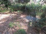
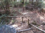
Despite clearing and some conservation work during 1988 for the State's Sesquicentennial, Bilgoman Well
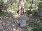
has become over grown again and has all but disappeared. Only the Heritage Trail Plaque identifies the site
amongst the undergrowth and swampy ground making investigation of the site a little hazardous. Timber
bench seats located nearby, and the path to the well are also being consumed by the bush.
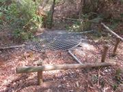
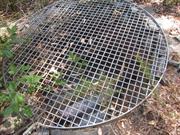
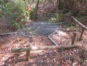
The well is a roughly circular stone construction at ground level. Within the well are steel poles bracing the
sides of the well. Over the top of the well is a circular stainless steel mesh cover which is held in place by
circular stainless steel tubes which have been driven into the ground. Several timber post fence structures
have been placed around the well. Timber bench seats are located near well and a plaque is fixed to a
concrete block near the well.
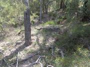
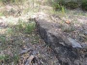
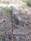
The convict ruins comprise the remnants if the base of some stone walls and hearths that roughly outline
several small buildings. The ruins are on a site that has been levelled and which roughly cuts into the slope of
the surrounding bush land. The ability to easily identify the site is slowly diminishing particularly as there is very
little remaining. Some archaeological work and interpretation of the site may better define its significance.
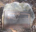
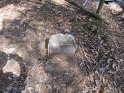
A nearby heritage Trail Plaque on a pedestal above the ruins has been vandalised and only the pedestal
remains.
In March 1846 "Bilgomen", the aboriginal name of a watering place, on Greenmount Hill was recorded in
Phillip La Mothe Snell Chauncy's field book, when he, on behalf of the State Government, surveyed the York
Road, now Great Eastern Highway. Near traces of a small encampment, he dug a 14 foot (4.2m) well,
which in his field book is shown as near tea tree thickets, in a dense "mahogany" forest and close to the 43
mile mark (ie. 43 mile form York).
For the purposes of maintaining the York Road, a convict depot was built in the vicinity of Bilgomen Well in
the 1850's. In 1856, Royal Engineer and Superintendent of works Lieutentant Du Cane described the depot
as being 2 miles east of a larger one at Greenmount (ie near Stirling Street), and with 25 men living in
substantial "vee" huts. These were slab huts for the overseer and stores.
In 1881, Government Surveyor CD Price, mentions the "Old depot and a clearing at the old depot". From
1882 until 1899, the area was a watering reserve. After 1899, it was a public park reserve from which 1915,
was the responsibility of the Greenmount Road Board.
According to MHHS records, there were ruins of mud huts, with 5ft walls, in existence in c. 1929 and these,
and the well, were a popular picnic site up to the 1940's. In more recent times, although its existence was
well known, vegetation and vandalism had overcome the site.
After extensive searches, local residents, Peter Fischer, Ron Mitchell and Chris Durrant re-discovered the well
and ruins in the early 1980's. Its authenticity was confirmed by Shire historian, Ian Elliot. After extensive work,
the site was officially opened on 26th January 1988, as part of the Australia wide Bicentennial celebrations.
Integrity:
Ruins
| Ref ID No | Ref Name | Ref Source | Ref Date |
|---|---|---|---|
| I Elliot; ibid. pp 25-26, 192 | |||
| HCWA Heritage Trail brochure | |||
| Betty Wylie, Oral Interview | 1995 | ||
| MHHS Files "Old York Road", | |||
| MHHS Files "Greenmount", |
| Ref Number | Description |
|---|---|
| 83 | MI Number |
| Library Id | Title | Medium | Year Of Publication |
|---|---|---|---|
| 6426 | A preliminary study of convict sites in Western Australia (draft). | Heritage Study {Other} | 1997 |
Historic site
| Epoch | General | Specific |
|---|---|---|
| Present Use | OTHER | Other |
| Original Use | OTHER | Other |
| Original Use | GOVERNMENTAL | Gaol |
| Style |
|---|
| Vernacular |
| Type | General | Specific |
|---|---|---|
| Wall | STONE | Other Stone |
| General | Specific |
|---|---|
| TRANSPORT & COMMUNICATIONS | Droving |
This information is provided voluntarily as a public service. The information provided is made available in good faith and is derived from sources believed to be reliable and accurate. However, the information is provided solely on the basis that readers will be responsible for making their own assessment of the matters discussed herein and are advised to verify all relevant representations, statements and information.